My thanks go to RTPI and especially to Judy Woollett who ... · My thanks go to RTPI and especially...
27
1 1
-
Upload
trinhnguyet -
Category
Documents
-
view
213 -
download
0
Transcript of My thanks go to RTPI and especially to Judy Woollett who ... · My thanks go to RTPI and especially...

1 1

My thanks go to RTPI and especially to Judy Woollett who looks after the Pepler award. I would also like to thank Ethan, Fred, Thor, Waykon and all of the people at PPS who helped me during my study trip. Thanks also to Rob Moore at Melbourne City council who was an unwitting contributor, for the time he spent in taking me through the story of change in Melbourne.
2

Evaluating a successful public realm (Beyond a physical pattern book)
1 Introduction
Big ambitions
The original prompt for this work was the report ‘Towards a fine city for people’ which Gehl architects were commissioned to do on behalf
of TFL and Central London Partnerships. The process of analysis and documentation as the basis of strategies for change interests me
generally and the Gehl process with examples of success in Copenhagen and Melbourne are of particular interest as a model. (Method and
success). In reading the report I was struck by two things- the immense complexity of the challenge facing London in aiming for a city for
people and the difficulty of reflecting the needs and aspirations of ‘the people’ in the study. In terms of capturing the aspirations of people
in processes of change I have long been interested in the work of Richard H. Whyte and Project for Public pace- the organisation most
closely associated with the work of Whyte. I proposed to explore the overlap between Gehlian and Whytean analysis and to examine how
their theories have been delivered upon. I wanted to somehow combine these strands to come up with a method of analysis that might
underpin strategies for change which address street and public space issues on a strategic basis without overlooking community values and
aspirations.
The report reflects these interests; it begins by setting out established theories and methodologies that have informed my thinking. It
develops some clarity about my distinct set of interests and explores standard UD tasks as opportunities to embed these in daily practice. In
conclusion it restates my personal position in terms of philosophies of public space and outlines how I see this philosophy informing my
professional practice. It also identifies tensions in my approach between the ‘documenter’ and the ‘representer’ in me and flags up that
these impulses need to be recorded and reported in a way that makes a clear distinction between the two.
3

2.0 Ways of thinking and looking
Broadly speaking Whyte and Gehl believe that successful public spaces support thriving communities and vibrant neighbourhoods towns and
cities. They both also believe that understanding the way that spaces are used is a good way of understanding what makes them work.
Focussing on commonalities my original proposal identified the challenges of embedding people focussed analysis into daily urban design
practice. In preparing for the trip I began to identify fundamental differences in the way that they set about achieving these common goals.
The detail of what originally motivated them; the skills and training each brought to their enquiries and how they translated their theories
into practice all influence the methodologies through which their ideals began to be used to deliver.
2.1 Whyte
Richard Whyte, mentor and friend to Jane Jacobs was at the centre of the reaction towards big planning – personified in NYC by the late
work of Robert Moses. In Whyte’s opinion the fundamental aim of planning and design was to create physical spaces that facilitate
community interaction. He also believed that cities were inherently messy places and that this was their advantage; by accommodating
things that invest public space with hustle and bustle, we create inviting environments for people and the city as a whole benefits.
While working with the New York City Planning Commission, Whyte initiated the "Street Life Project," in which Whyte and his students took
to the streets to observe film and document what was happening in under-used city plazas and on crowded pavements. His direct
observation techniques documented and described public life in an objective measurable repeatable way. Whyte believed that this
documentation should inform policy and design proposals. Engaging directly with NYC planning Commission his work was the basis of the
1875 overhaul of New York City zoning code. His work also fundamentally reframed the way that many planners practiced- referring back to
the user behaviour as the legitimate source for identification and analysis of need.
4
2.2 Project for Public Space
Project for Public Space (PPS) also connect successful places and successful communities. PPS was founded on the principles of Whyte,
planning and design for them, as for Whyte, is rooted in the community. Their placemaking model takes account of the conditions and
elements that help create successful places, but critically it embraces a whole methodological approach to engaging with change. In
contrast with what they call the project/discipline approach, placemaking focuses on the shared aim of creating successful places and
thriving communities. PPS use this model to structure engagement with communities helping people to engage with issues beyond the
individual. Through this process PPS aim to generate more compelling and rooted strategies for improvement or change.
Fig 1 Place diagram
“If you plan and design for cars and traffic you get more cars and traffic. If you plan and design for people and places place you get people and places”
5

2.3 Gehl
Jan Gehl, a practising architect and (recently retired) academic, has long been interested in the interaction between psychology, sociology
architecture and planning. In the mid sixties he was awarded a research grant by the Royal Danish school of Architecture to pursue this line
of enquiry. In 1971 Life between buildings was published, in it Gehl began to look at places, behaviours and needs as a framework for
analysing and designing.
Gehl identifies shifts in society that impact upon the role of public space and that the need to take these shifts into account when planning
and designing public space. Where in the 19th century much essential activity took place in public space and as a result many social/optional
functions also happened there. Today much of those essential activities have moved indoors. In tandem with this shift of activities into
buildings, increasing levels of car ownership has had an impact on the way that we think about and design public space, or in some cases
our abandonment of it.
Fig 2 Necessary and optional activities over time
6

Public life in these conditions is a fragile thing. If we want it we need to
analyse and design to support it. Gehl’s thesis is that optional activities by
their nature involve value judgements and that people will inevitably choose
good quality spaces over poor. Through his work Gehl finds that whenever
quality is provided people come, he writes: “Access to other people, to
possibilities for experience and recreation among others are in high demand,
and these opportunities have important roles for upholding or strengthening
the overall policies for friendly, humane, open, democratic and safe
societies.” So Gehl, in common with Whyte, thinks of public space as the
supporting infrastructure for public life.
Building on the work in Life between buildings Gehl identifies the key elements
of successful public space which combine physical and user aspects and eschew
the usual emphasis on aesthetics without disregarding them. Engaging with
established survey and analysis Gehl realised that professionals focussed on
cars and traffic not people and public life. The approach he developed over the
years responds to this mismatch by recording systematically how people use
the city- making them visible and embedding their needs in strategies for
change.
Fig 3 12 Key quality criteria
7
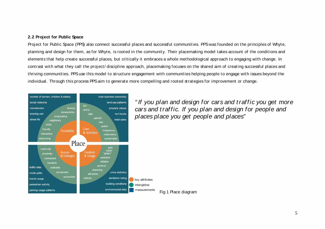
At the strategic scale evaluation of key spaces is combined with the process of systematically recording public life at intervals to test the
success of strategies in fostering public life. Towards a fine city for people is the first such study for London, other cities have been engaging
this two pronged approach to rewire themselves for life in the 21st century.
Fig 4 Numbers of dwellings in central Melbourne 1983- 2002
8

2.3 A statement of intent
Like Whyte and Gehl, I’m convinced that public space has the potential to make significant contribution to society beyond simply
connecting destinations. Looking across UK and international practice -after almost a century of planning and designing for movement there
seems to be a growing appreciation of the need to rewire cities for dwelling. I want to engage with this agenda and to ensure that through
my work I help to deliver humane, democratic places.
If we accept that public spaces are physical and social spaces then processes and strategies for change must take account of each in a
meaningful way. Just as public space needs reconfiguring to support public life so to do the systems- social and professional- that deliver
public space. The community in all of its configurations has a valid and important role to play in the development of solutions and strategies
for change. In the UK current government thinking identifies local authorities as ‘placeshapers’ and underlines their role managing and
delivering change. Within this context Professionals from a variety of disciplines (from the facilitators of PPS to the practitioners of Gehl
and beyond) play a role in inspiring challenging and enabling these solutions and strategies to be delivered through their expertise and the
tools of analysis and communication.
No one person can bring all of these skills and knowledge to the table. Embracing these views of public space and the roles of the various
stakeholders I want to contribute to these processes effectively by mastering the tools of my trade. As an urban designer understanding how
places work (spatially and socially) and interact at different scales, processes of delivery and the organisational structures behind those
spaces are my core skills. In my work I will always have to engage with both civic and community structures and processes. While
community engagement is not a core skill it is certainly an incredibly important one. Mapping my skills and interests over the work of Whyte
and Gehl and over the current context for my work I find that my interest rests on local authority systems of change. Focussing on these
systems will enable me to contribute more effectively to a shift in thinking nationally that is beginning to see public space as more than link
9

between destinations. Embedding people into my analysis and understanding of successful space acknowledges that public life needs to be
supported and nurtured through any process of change.
Fig 5 Places for people © S McLaren
10

3.0 Restating the problem
There are physical characteristics at various scales that influence the ability of public space to support public life. There are social issues
too- so that a space that succeeded for some time can be brought to its knees because of a shift in the way that people use it. How can I
embed a consideration of both in my analysis? (and development of strategies for change?)
3.1 Trip preparation
In preparation for the trip I made contact with PPS to discuss potential projects for cross comparison. At this stage it became clear that
their projects in the New York area were less advanced than I had understood when writing the original proposal. However just as my
knowledge of the work of Whyte had developed in the interim, my interest in how PPS were delivering on his original principles and
engaging with current agendas of change, from a campaigning transportation and community perspective to their growing ‘context sensitive
solutions’ approach, had also grown. Touching base with PPS also helped me to come up with a final short list and informed my outsiders’
analysis with some local knowledge.
3.3 Refining the study structure
To be able to analyse effectively and to generate robust strategies for change I need to have a good understanding of the tools available
and the particular problem that each tool uniquely addresses. This includes methods of analysis as well as the role of the professional in
understanding and representing the link between social and spatial characteristics at different scales and potential strategies for change.
The focus of the fieldwork is therefore on the neighbourhood context of particular streets and spaces and how each informs the other.
The study trip was structured to incorporate street studies in three different neighbourhoods. The fieldwork combines user observation and
detailed documentation and measurement of the spatial characteristics of the neighbourhood context, the local high street and key spaces
along the street. The balance between provision for the car and the social functions is used as an indicator for whether it’s planned and
11

designed for movement or for public life. The analysis engages with different scales at increasing levels of detail so that macro and micro
issues inform the conclusions.
Fig 6 Case study locations
4. Fieldwork
For each study I carried out specific tasks to provide a cross reference with the other spaces:
• The neighbourhood analysis is based on an estimated 10 min pedshed and aims to establish an understanding and impression of the
physical and social context of a street. The pedshed is walked; the physical and use characteristics are documented through
photography maps and written notes.
12

• The street analysis aims to identify where the street begins to support neighbourhood functions (such as meeting space social space
local service hub etc). For this stage the street is walked a number of times, intersections are recorded in detail through
photography, measurement and observation; ‘gateways’ or points where the physical and social context and range of observable
activities begin to intensify are fixed.
• At the final scale the street level observation informs the identification of the point where the balance flips and the street begins to
function as a neighbourhood social space. Detailed measurements, photographic documentation and observation are the basis for
the analysis at this scale.
Inevitably I used the space myself walking it having coffee and lunch in it doing simple errands getting a feel for how everyday activities
were accommodated.
Fig 7 study scales
13

4.1 Analysis
Collecting the data there was time for reflection and to test some hunches. The challenge was always going to be in deciding what not to
record or note down or to spend time exploring. Reviewing the data and shaping up the way that that it could be organised to document
and communicate the character of the places that I had visited and to tell me more on examination than the one off visit had. I organised
the images reviewed the video clips and reworked the descriptive notes. I referred through the three scales to inform the feeling and the
functioning of the study streets and spaces.
Transcribing, beginning to construct initial maps and diagrams this stage began to identify obvious commonalities and quirks. The process
felt as much an exploration as the fieldwork. It took me down blind alleys. I had to step back from it. With distance I began to pick up key
threads and understand which tasks that were telling me something and which were acting as active distraction. Writing, looking and
drawing, each activity helped me to unearth different aspects of the spaces I scrutinised. The activities helped me to think through the
spaces in very different ways.
The richness of the analysis I find is not only in comparing across scales but across case studies. Impressions and experience of Gansevoort
as well as conversations about the community agenda there prompt me to think about the breakdown in the Manhattan grid that this
neighbourhood has grown out of and the inevitability of that particular space. These have not entirely left me when I visit Austin St with its
own particularities of urban structure and again I wonder about the influence of the context on the street and the inevitability of the spaces
that I examine in detail. The community or people there when I’m there also give me cause to reflect and wonder synagogue goers and old
ladies at lunch in Austin St give a distinct impression that’s forever attached to the place for me. In Myrtle Ave the general ease of one side
of the neighbourhood contrasts with the hostile/hard up feeling of the other. The street itself polarises too and in focussing on the gate way
spaces I feel exposed and observed when I’m doing my thing outside Whitman projects.
14

5. Conclusion
Systematically working through the thinking of Gehl and Whyte and speaking with colleagues in PPS made clear to me that not only the
original motivations, skills and training of each influenced the development and delivery of their principles but that the wider social context
did too. While Gehl operating in the Danish context has been able to work with the city authorities of Copenhagen thereby testing the
delivery of his principles strategically and systematically, Whyte and PPS have a much tougher challenge in the US in getting the links
between placemaking and quality of life onto the radar of national, state or city government. Combined with their origin in the reaction to
big planning grassroots activism and community rather than institutional engagement has proved the most effective way to push the agenda
in the US. However it is interesting to note that this work seems to be paying dividends and shifting the work of PPS into a more
institutional framework as more and more state Departments of Transport begin to engage with the placemaking agenda thorough their
emerging Context Sensitive Solutions work.
This research has also convinced me that a range of professionals in conjunction with the community bring the requisite skills experience
and knowledge to the table, ad that the common goal needs to be creating places for people and communities to thrive in. I am also
convinced that proposals to keep things as they are will never work. Better to embrace the simple fact that change (physical and social) is
constant and that places and people need to be equipped to face the future with confidence rather than retreating into to some idealised
past or future where everything is perfect or somehow ‘finished’.
These conclusions underline for me the importance of clarity around the role/ overlap of each contributor to the process. Personally I am
interested in understanding what and how other experts operate and complimenting that rather than claiming too much for my own
expertise or disregarding another’s. To my mind the act of community engagement is as specialised as the urban designer or landscape
architect. Each role has the potential to bring with it established ways of thinking and doing. Better to acknowledge this and to harness the
experience and knowledge than to claim that one group uniquely does not bring personal or professional socialisation to their work.
15
Moving from theory to analysis highlighted underlying tensions in my work. On the one hand I’m drawn to processes that allow me to record
and document places in a representative replicable way. On the other I am interested in the humane aspect of place and how personal
impressions can bring this to the process. Objectively the process has begun to establish a foundation for future work, the movement
through scales certainly worked and the tools for analysis seem to support original hunches, while clearly needing further testing and
refinement. But critically the regimented documentation is complimented by personal impressionistic notes and images. I bring both
professional and the personal to the process. It helps me to build a more rounded picture or story of a place and enriches the analysis. It
compliments and maybe challenges existing community stories but it in no way replaces or negates them. This was the surprise and perhaps
most challenging conclusion for me.
“The Street is the river of life of the city, the place where we come together, the
pathway to the center.”
William H. Whyte.
16
Study sheets
01 Greene Point – Myrtle Avenue
02 Forrest Hills – Austin Street
03 Meatpacking District – Geansevoort
17
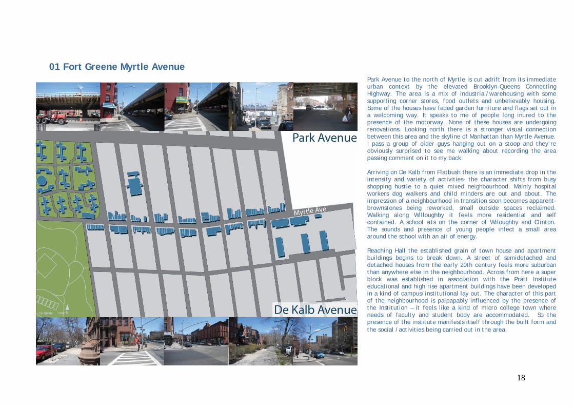
01 Fort Greene Myrtle Avenue Park Avenue to the north of Myrtle is cut adrift from its immediate urban context by the elevated Brooklyn-Queens Connecting Highway. The area is a mix of industrial/warehousing with some supporting corner stores, food outlets and unbelievably housing. Some of the houses have faded garden furniture and flags set out in a welcoming way. It speaks to me of people long inured to the presence of the motorway. None of these houses are undergoing renovations. Looking north there is a stronger visual connection between this area and the skyline of Manhattan than Myrtle Avenue. I pass a group of older guys hanging out on a stoop and they’re obviously surprised to see me walking about recording the area passing comment on it to my back. Arriving on De Kalb from Flatbush there is an immediate drop in the intensity and variety of activities- the character shifts from busy shopping hustle to a quiet mixed neighbourhood. Mainly hospital workers dog walkers and child minders are out and about. The impression of a neighbourhood in transition soon becomes apparent- brownstones being reworked, small outside spaces reclaimed. Walking along Willoughby it feels more residential and self contained. A school sits on the corner of Wiloughby and Clinton. The sounds and presence of young people infect a small area around the school with an air of energy. Reaching Hall the established grain of town house and apartment buildings begins to break down. A street of semidetached and detached houses from the early 20th century feels more suburban than anywhere else in the neighbourhood. Across from here a super block was established in association with the Pratt Institute educational and high rise apartment buildings have been developed in a kind of campus/institutional lay out. The character of this part of the neighbourhood is palpapably influenced by the presence of the Institution – it feels like a kind of micro college town where needs of faculty and student body are accommodated. So the presence of the institute manifests itself through the built form and the social /activities being carried out in the area.
18

19

The edge of Fort Grene Park is very rich the Whitman Projects and brownstone neighbourhood enclose it. They also feel a lot more separate than the distance would suggest. Broadly speaking the Brownstoners use the park and the Whitmanites use the edge of the project as their public forum. Throughout the day numbers of mainly men, almost entirely African American, congregate in this space rising from 6 when I arrive to 21 at 3:30 and dropping off again to around 7. I see three men using the park edge which is wide, lined with seating and trees. The gateway has its gatekeepers. I’m intrigued about why the more accommodating park edge doesn’t appeal. I wonder how the weather affects these patterns and would really like to come again in mid summer. Looking at the edge more obviously designed for people and congregation in detail I feel self conscious pacing and snapping and videoing across the street from lots of people who are about for the duration of my work.
20

02 Forrest Hills – Austin StreetOne block north of Austin Street is an essentially single sided street with regular blocks between Ascan Avenue and Yellowstone Boulevard, one way traffic and parallel parking along both sides. The other edge side of the street exists but I count 19 lanes of traffic between building fronts. Traffic moves slowly- drivers have left the busy Boulevard and are looking for parking. Between 70th Rd and Yellowstone Boulevard is a small park groups of people passing through or sitting and watching life go by. At Yellowstone the grid breaks down and I turn left to find the southern edge of Austin Street. Following the south of Austin Street I walk along a residential terrace lined street that reminds me of British interwar suburbia. A number of these buildings have offices in the ground floor. Moving east there is a shift to 6 storey half timbered apartment blocks. People are mainly running errands or working in their gardens. There are signs telling me that I’m on a private street and that the speed limit is 20mph. I’m in Forest Hills Gardens a privately owned community, planned and laid out in the early 20th century, according to garden city principles. I come to the back of the Westside Tennis club and continue east now on a kind of service lane between the tennis club and a rail embankment. At the end of this lane I join Forrest Hills Garden proper. 5-6 storey apartment blocks and town houses are built to the edge of the plot. It’s a single sided street which faces a rail embankment. There seem to be more people around running errands, walking dogs and seeing visitor to their cars. Pealing off my route I walk a few blocks back and am in an idealised suburban landscape detached houses, gently curving streets and impressive mature trees. I get back on track and continue east along Burns St reaching Station Square where 71st Ave crosses Austin St. The square is an oasis of calm less than 100 meters from the busy shopping street. East of Station Square is more of the same in terms of buildings with some variation of the street alignment and position of buildings back from the front edge of the plot. At Ascan Avenue traffic volume and speed increases significantly. Crossing this street feels like leaving.
21

22

23
Austin St’s relationship to the major routes and the elongated block structure on the south side appear to influence the way that drivers and pedestrians behave. It’s a busy Saturday morning when I arrive. The volume of people in cars and on foot builds to a peak at about 2-3 pm. It strikes me that people are crossing mid block. Paying closer attention I see that the Rds and Aves to the north act as feeders and traffic moves along the length of Austin St. looking for parking, which is usually found back on those feeder streets. Speeds of above 20 mph occur but much lower speeds are the norm. So Austin St is one of those places where the impact of traffic is limited by lower average speeds. The lower speeds seem to result from a mix of volume (shoppers and drivers) and space scanning. At 71st Avenue the critical mass of activity make it an almost shared intersection- drivers carefully nose around corners. Forrest Hills station and the connection through to Austin St would suggest Station Square to be a bustling place. Instead commercial properties are unlet. I assume that its private status and sensitivities to mixed use bring with it a degree of complexity and a resistance to commercial activities. The behaviour of pedestrians and drivers continues to be an uncharacteristic for the New York area. Again this may be linked to the status of the neighbourhood. Speed limits are set at 20mph and parking is strictly resident only, so speed and spill over volume are limited by regulation. The private status no doubt explains the unusual design of the space. Finished in red brick no lining, limited signing and only one set of traffic lights regulate the space. The design of the surrounding buildings and access to the station creates an unexpectedly animated square even if numbers of people are limited.

03 Meatpacking District - Gansevoort
24
The story of Gansevoort is one of radical change from meatpacking industrial, to industrial clubbing, to ubercool clubland to Designated Historic district. Thor and Waykon from PPS were good enough to take some time out from the office to talk me through the work that they have been doing with the community in rethinking what Gansevoort is. The meatpacking district announces itself on the Manhattan map by colliding with the established grid at a 45 degree angle; this in itself gives rise to all sorts of strange triangular spaces some of which are formalised as parks like Jackson Square others which aren’t (Jane and 8th Avenue). These spaces ameliorate the impact of the huge bounding streets and provide unlikely opportunities for pockets of local shopping and stopping to occur. The edges of this clash zone acted for this study as the natural borderland. I walk the streets between 14th and Bethune. The West Village is clearly well loved and looked after neighbourhood. Mostly residential other activities incorporated in to the neighbourhood in industrial commercial and converted residential buildings. The dog walkers and errand runners mix with workers . The dog walkers act as the gate keepers, the eyes on the street. Our paths crisscross and they begin to eye me curiously. We establish nodding relationships that are sustained for the course of the day. Moving north things get notably hipper, cool even. The meatpackers have all but finished for the day, restaurants are not in full lunch swing and shops are intentionally unbusy- six items of clothing float in several thousand square feet of retail space. I see five separate fashion/music shoots in the course of a day, neighbourhood as the manifestation of cool. To the West the Joe DiMaggio highway separates the area from the Hudson River and its park. East of the highway an elevated freight line, is being transformed into a linear park and is the focus for a mini building boom. This particular part of the neighbourhood has found its own fulcrum and is reconfiguring itself around it.

At the heart of the neighbourhood the dominant triangle is Gansevoort plaza. A wide open space apparently one acre in total I have dinner here late on my first day in town I watch the space begin to fill after 11 and begin to act as glamorous and decaying backdrop to the wider photo shoot that is weekend clubbing in this part of NYC. When I finally carryout the study I watch visitors arrive in the space orientate themselves and locals passing through with ease and purpose. Drivers approach at low speeds and, uniquely in my experience of Manhattan, seem tolerant of pedestrian misbehaviour. There are no markings or traffic lights signs at the edge of the space spell out rules of engagement. Bringing with me all the debate around signs, lines and regulation that is current in the UK and Europe I marvel at the space and how it works. I stand with Thor in the centre of the space; I film, he talks me through the issues identified through their work with the community which ranges from workshops, observation, and time-lapse photography to initial proposals for rewiring this key neighbourhood space. I point out the lack of conflict and the unintentional elegance of the space. He points out the absence of opportunities to occupy the space and the clashes that emerge when the taxis, clubbers and meatpackers try to use the space together. There are issues in the wider context with street widths and traffic movement there is a desire to create a flexible public space- a plaza in the plaza. I’m made aware that I’m romanticising the space. PPS engagement has essentially enabled the community to set the project brief. The Department of Transport has now commissioned transportation and planning consultants to develop proposals further. Officials have committed to community engagement throughout development of proposals. It seems to me to be a case study in how the experience of PPS can be brought to bear on a key space in their own home town. The wider engagement of New York Streets renaissance and the Open Planning Project signify to me the power of grassroots allegiances in influencing citywide debates.
25

26

27 27