MRGO – A Brief Review of Impacts Post-Katrina Progress · MRGO – A Brief Review of Impacts &...
40
MRGO – A Brief Review of Impacts & Post-Katrina Progress By John Lopez, Ph.D. Executive Director Lake Pontchartrain Basin Foundation Presented to Restore Americas Estuaries October 2012 See SaveOurLake.org
Transcript of MRGO – A Brief Review of Impacts Post-Katrina Progress · MRGO – A Brief Review of Impacts &...

MRGO – A Brief Review of Impacts &
Post-Katrina Progress
By
John Lopez, Ph.D.
Executive Director Lake Pontchartrain Basin Foundation
Presented to Restore Americas Estuaries
October 2012 See SaveOurLake.org
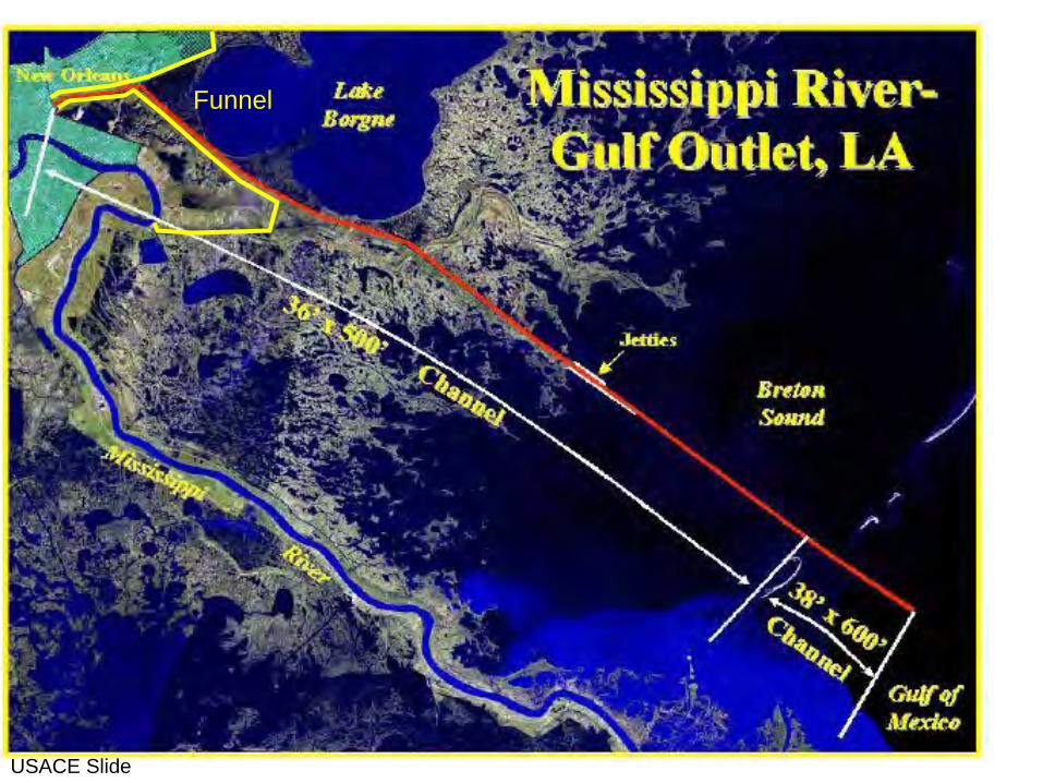
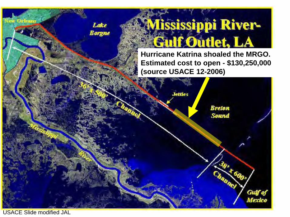
USACE Slide
Funnel

1965 Hurricane Betsy
USACE Slide modified JAL


Quantified Habitat Impacts of MRGO in Louisiana
Marsh loss 27,600 acres
Wetland habitat conversion 38,000 acres & Salinity shift of lakes 488,400 acres
Dead zone of Lake Pontchartrain 64,000 acres
Total 618,000 acres
Lake Borgne
Biloxi Marsh
Wetland loss in color representing various time periods of loss due to MRGO

Bayou la Loutre
1 mile
MRGO spoil bank
MRGO spoil bank


Quantified Habitat Impacts of MRGO in Louisiana
Total 618,000 acres
Marsh loss 27,600 acres
Wetland habitat conversion 38,000 acres & Salinity shift of lakes 488,400 acres
Dead zone of Lake Pontchartrain 64,000 acres
10,000 acres of cypress swamp lost
10 PPT
15 PPT
Salinity lines 3 years after MRGO completion (LA DWF, 1971)
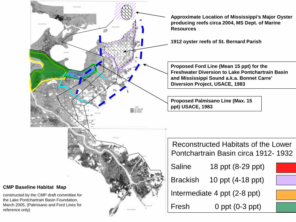
Proposed Ford Line (Mean 15 ppt) for the Freshwater Diversion to Lake Pontchartrain Basin and Mississippi Sound a.k.a. Bonnet Carre’ Diversion Project, USACE, 1983
Proposed Palmisano Line (Max. 15 ppt) USACE, 1983
Approximate Location of Mississippi’s Major Oyster producing reefs circa 2004, MS Dept. of Marine Resources
1912 oyster reefs of St. Bernard Parish
Reconstructed Habitats of the Lower Pontchartrain Basin circa 1912- 1932
Saline 18 ppt (8-29 ppt)
Brackish 10 ppt (4-18 ppt)
Intermediate 4 ppt (2-8 ppt)
Fresh 0 ppt (0-3 ppt)
CMP Baseline Habitat Map
constructed by the CMP draft committee for the Lake Pontchartrain Basin Foundation, March 2005, (Palmisano and Ford Lines for reference only)

Lake Borgne
19th century
Fort Proctor
Shell Beach
Bank Erosion 35 feet / year average
Shoreline Erosion
15 feet / year average
1 mile
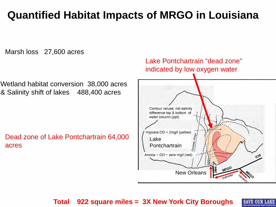
Quantified Habitat Impacts of MRGO in Louisiana
Total 922 square miles = 3X New York City Boroughs
Lake Pontchartrain “dead zone” indicated by low oxygen water
Marsh loss 27,600 acres
Wetland habitat conversion 38,000 acres & Salinity shift of lakes 488,400 acres
Dead zone of Lake Pontchartrain 64,000 acres
Lake Pontchartrain
New Orleans

“St. Bernard Parish has long requested the closure of the channel because, in addition to the environmental damage, they believe that the channel serves as a funnel for hurricane surges to enter the parish.”

Hurricane Katrina: A Watershed Event in American History MRGO’s Legacy of Destruction Widespread Levee Failures Inadequate Emergency Response 1,400 lives lost in Louisiana 200,000+ homes flooded or destroyed in New Orleans 60% of New Orleans & St. Bernard Parish residents are still displaced Over $100 Billion in assets lost
Post Katrina: Historic Institutional Issues
2
USACE Slide modified JAL
Hurricane Katrina shoaled the MRGO. Estimated cost to open - $130,250,000 (source USACE 12-2006)

CITY OF NEW ORLEANS C RAY NAGIN, MAYOR
MAYOR’S OFFICE OF PLANNING AND DEVELOPMENT
Mayor’s Office of Planning and Development STATEMENT ON CLOSURE OF THE MRGO
__________________________________________ In service to the City of New Orleans as Chief Development Officer, I am writing you to offer the support and assistance of our staff and me to your staff and you as well as to those in Congress who are working to advance legislation that addresses the de-authorization of the Mississippi River Gulf Outlet. Recognizing that the outlet should be closed, we are suggesting shallow draft navigation be allowed to continue. To facilitate a smooth transition, we are asking Congress to secure an appropriate level of resources to relocate businesses presently dependent upon the outlet to suitable locations within the Port of New Orleans. Your support of this request would be greatly appreciated. Discussion of the closing of this outlet has continued for too long. Now is the time to act. Protection of our coastline and wetland restoration is paramount if we are to avoid further catastrophic losses in Southeast Louisiana. We urge action immediately to protect our homes and businesses in the New Orleans area, and we look forward to working with you to achieve this outcome. Donna Addkison Chief Development Officer Contact: David Robinson-Morris (504) 329-1250

Comprehensive Habitat Management Plan
2006 Coastal Sustainability Program
Lake Pontchartrain Basin Foundation
SaveOurLake.org

Mister Go Must Go
A GUIDE FOR THE ARMY CORPS’ CONGRESSIONALLY-DIRECTED CLOSURE OF THE MISSISSIPPI RIVER GULF OUTLET (MRGO)
Briefing December 5, 2006
AUTHORS
Dr. John Day, Professor Emeritus, LSU Department of Oceanography and Coastal Sciences / School of the Coast & Environment
Dr. Mark Ford, Coalition to Restore Coastal Louisiana Dr. Paul Kemp, LSU – Hurricane Center
Dr. John Lopez, Lake Pontchartrain Basin Foundation
ENDORSED BY St. Bernard Parish
Lake Pontchartrain Basin Foundation Coalition to Restore Coastal Louisiana
Environmental Defense Gulf Restoration Network
Louisiana Wildlife Federation American Rivers
National Wildlife Federation
1

Lake Pontchartrain
Lake Borgne
Reach 1 Surge highway into New Orleans
100 sq. mile dead zone in Lake Pontchartrain
Reach 2 Incompatibility of a large channel directly in front of the hurricane protection levee
MRGO breached the Bayou la Loutre ridge severely altering the estuarine hydrology
Saltwater intrusion causing habitat loss and change, including loss of cypress forest to buffer levees
Ship wakes cause further wetland loss & loss of buffer
Hydraulic barrier to freshwater diversion for Biloxi marsh & Mississippi Sound
Reach 3 High dredge maintenance due to infilling in Breton Sound
Breach of the barrier and disruption of sediment transport
Biloxi Marsh IH
NC
Reach 1 New Orleans
Flooded communities in Orleans and St. Bernard Parishes
Lake Pontchartrain
Reach 1 Surge highway into New Orleans
100 sq. mile dead zone in Lake Pontchartrain
Reach 2 Incompatibility of a large channel directly in front of the hurricane protection levee
MRGO breached the Bayou la Loutre ridge severely altering the estuarine hydrology
Saltwater intrusion causing habitat loss and change, including loss of cypress forest to buffer levees
Ship wakes cause further wetland loss & loss of buffer
Hydraulic barrier to freshwater diversion for Biloxi marsh & Mississippi Sound
Reach 3 High dredge maintenance due to infilling in Breton Sound
Breach of the barrier islands and disruption of sediment transport
Flooded communities in Orleans and St. Bernard Parishes
IHN
C New
Orleans Biloxi Marsh
Base map U.S. Army Corps of Engineers, 1985
Surge “funnel”
Former Cypress Swamp

Reach 1 Reach 3 Reach 2
Environmental Damage
Post-Katrina status in 2005 Three Reaches & Three Issues

20
The “Funnel” Seaward
Lake Borgne
5

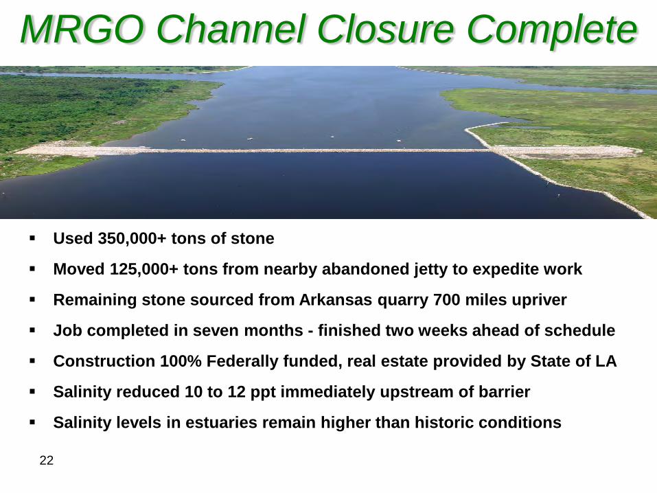
Used 350,000+ tons of stone
Moved 125,000+ tons from nearby abandoned jetty to expedite work
Remaining stone sourced from Arkansas quarry 700 miles upriver
Job completed in seven months - finished two weeks ahead of schedule
Construction 100% Federally funded, real estate provided by State of LA
Salinity reduced 10 to 12 ppt immediately upstream of barrier
Salinity levels in estuaries remain higher than historic conditions
MRGO Channel Closure Complete
22

0.0
2.0
4.0
6.0
8.0
10.0
12.0
14.0
16.0
18.0
20.01
110
219
328
437
546
655
764
873
982
1091
1200
1309
1418
1527
1636
1745
1854
1963
2072
2181
2290
2399
2508
2617
2726
2835
2944
3053
3162
3271
3380
3489
3598
3707
3816
3925
4034
4143
4252
4361
4470
4579
4688
4797
4906
5015
5124
5233
5342
5451
5560
5669
MRGO Salinity Near Shell Beach
June 2009- Date of Bayou la Loutre Closure dam completed
December 2008
August 2009
Source – USGS preliminary data

Reach 1 Reach 3 Reach 2
Environmental Damage
Post-Katrina status in 2005 Three Reaches & Three Issues
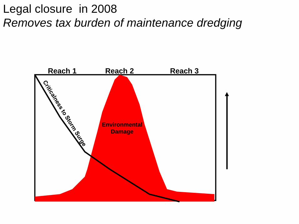
Reach 1 Reach 3 Reach 2
Environmental Damage
Legal closure in 2008 Removes tax burden of maintenance dredging

Reach 1 Reach 3 Reach 2
Residual
Environmental Damage
Physical Closures in 2009 - Rock Dam & Surge Barrier Reduced the dead zone in Lake Pontchartrain

Reach 1 Reach 3 Reach 2
Residual
Environmental Damage
Completion T- walls on MRGO levee in 2011

Detached Peak Surge
Multiple Lines of Defense and Hydrologic Habitat Restoration Without surge
With surge
Source: Lake Pontchartrain Basin Foundation & Coalition to Restore Coastal Louisiana, 2008)

Study Area: 3.86 million acres (6,023 miles2) of land and open water
Lake Borgne ecosystem and areas potentially affected by the channel
GIS by John Defraites
29

TYPE DIRECT LOSS (-)
INDIRECT LOSS (-)
INDIRECT GAIN (+) NET
FRESH / INTERMEDIATE -3,400 -3,400 -6,800 BRACKISH -10,300 -19,200 11,400 -18,100 SALINE -4,200 19,200 +15,000 CYPRESS -1,500 -8,000 -9,500 SHALLOWS -4,800 4,800 0+ ADDITIONAL* -500 -3,400 -3,900 TOTAL -24,700 -34,000 -23,300
Habitat Impacts
*Direct impacts due to additional erosion between 1990 and 2008. Indirect impacts due to increased salinity.
30

31
Central Wetlands Habitat Change 1956 Habitat
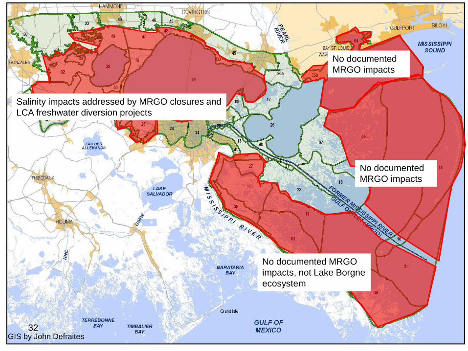
Salinity impacts addressed by MRGO closures and LCA freshwater diversion projects
No documented MRGO impacts, not Lake Borgne ecosystem
No documented MRGO impacts
No documented MRGO impacts
GIS by John Defraites 32
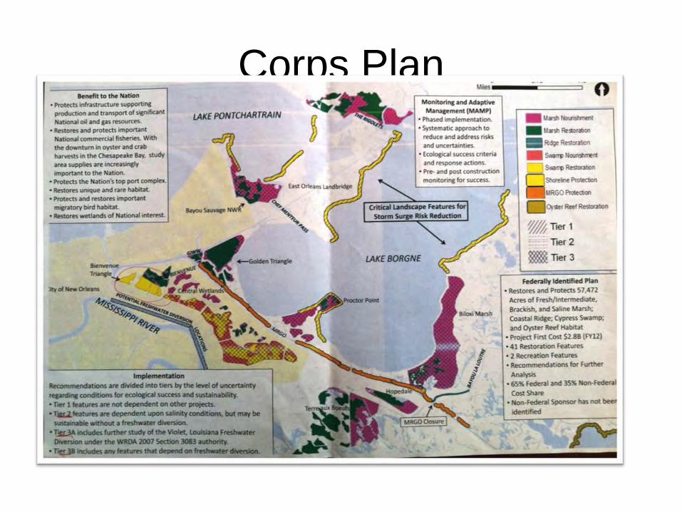
Corps Plan

State Master Plan

State Master Plan
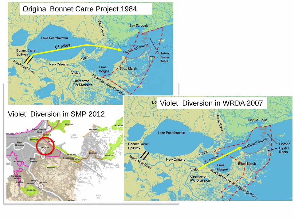
Original Bonnet Carre Project 1984
Violet Diversion in WRDA 2007 Violet Diversion in SMP 2012

37
Lake Borgne Dredging Volumes
• 157 million cubic yards of material.
Public Comments related to:
• Potential for increasing storm surge by deepening the lake.
• Potential impacts to fisheries.
• Objection to “internal borrow” i.e. not introducing new sediment.
• Gulf sturgeon critical habitat.
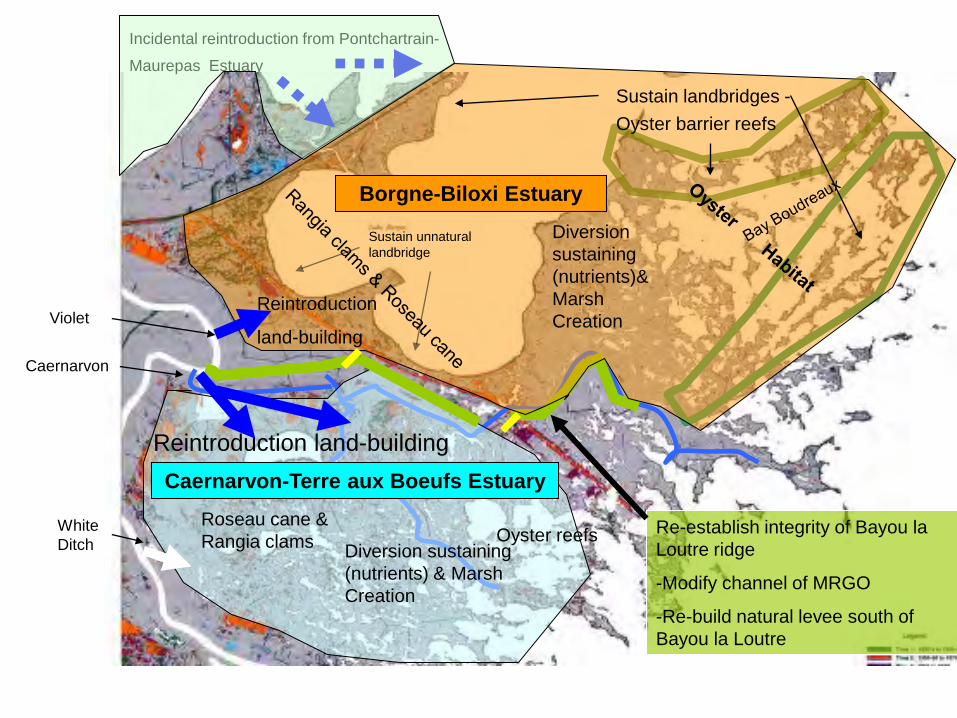
Reintroduction land-building
Diversion sustaining (nutrients)& Marsh Creation
Reintroduction
land-building
Diversion sustaining (nutrients) & Marsh Creation
Re-establish integrity of Bayou la Loutre ridge
-Modify channel of MRGO
-Re-build natural levee south of Bayou la Loutre
Roseau cane & Rangia clams Oyster reefs
Sustain landbridges - Oyster barrier reefs
Incidental reintroduction from Pontchartrain-
Maurepas Estuary
Borgne-Biloxi Estuary
Caernarvon-Terre aux Boeufs Estuary
Sustain unnatural landbridge
Caernarvon
White Ditch
Violet

Post Katrina MRGO Milestones
2005 Hurricane Katrina
2006 Suspension of Dredging of MRGO
2007 WRDA -MRGO closure & restoration plan by 2008
2008 Closure report triggering the Legal de-authorization
2009 Rock dam on MRGO at Bayou la Loutre Ridge
2009 Surge barrier on MRGO at the “Funnel”
2011 T-Wall levee completed along the MRGO
2009 -2012 minor restoration projects by Corps and state
2012 State Mater Plan with MRGO restoration
2012 Completion of Corps Feasibility Report
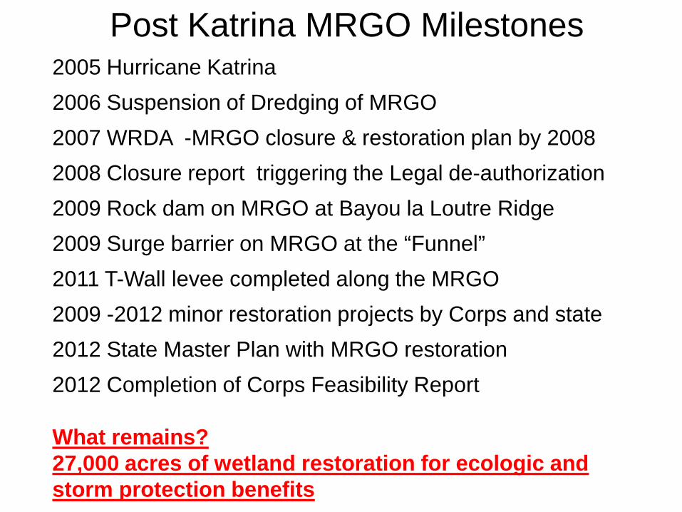
Post Katrina MRGO Milestones
2005 Hurricane Katrina
2006 Suspension of Dredging of MRGO
2007 WRDA -MRGO closure & restoration plan by 2008
2008 Closure report triggering the Legal de-authorization
2009 Rock dam on MRGO at Bayou la Loutre Ridge
2009 Surge barrier on MRGO at the “Funnel”
2011 T-Wall levee completed along the MRGO
2009 -2012 minor restoration projects by Corps and state
2012 State Master Plan with MRGO restoration
2012 Completion of Corps Feasibility Report What remains? 27,000 acres of wetland restoration for ecologic and storm protection benefits