Moray and Caithness - scottishgeology.com and Caithness: A landscape fashioned by geology The far...
80
Moray and Caithness: A landscape fashioned by geology The far north-east of Scotland encompasses a wide range of landscapes, from the rolling hills of Moray and the coastal flagstone cliffs of Caithness, to the blanket peat bogs of the Flow Country and the ancient rugged mountains of eastern Sutherland. These landscapes have all formed during a long and complex geological history, from rocks that were buckled and warped by continental collisions that occurred many hundreds of millions of years ago, to the sculpting of the hills and valleys by glaciers just a few thousand years ago. Since Neolithic times, the inhabitants of the region have made use of its geological resources and also changed its appearance irrevocably. This book describes the whole of that geological and human history, laying bare the events that have shaped the landscape of this remote but intriguing corner of Scotland. About the Authors Clive Auton has worked as a field geologist in Scotland for almost thirty years on many aspects of the rocks and landscape, particularly in the Highlands and Northern Isles, but also around the Moray and Solway firths. He is particularly interested in the glacial history of Moray and Caithness and also in the Old Red Sandstone rocks of the Orcadian Basin. Clive is an active member of the Quaternary Research Association and has led many geological field excursions to the Caithness and Moray area. Jon Merritt has worked as a field geologist on various aspects of the superficial deposits and glacial landforms of Scotland for over thirty years, particularly in the Highlands and Islands. He is an enthusiastic devotee of the Quaternary Period, the last two million years or so of the geological record, when glaciers, melt-waters and cold climate processes fashioned and created so much of the landscape we see today. Jon is also an active member of the Quaternary Research Association and has published widely. Kathryn Goodenough has studied the geology of Scotland for some fifteen years. She is particularly interested in the ancient rocks found in the Northern Highlands, which provide a record of the earliest part of Scotland’s history. She has studied rocks of similar ages in many other countries, but still thinks that some of the most fascinating geology in the world is to be found in Scotland. ISBN 978 1 85397 609 4 Price £7.95 Scottish Natural Heritage www.snh.gov.uk MORAY AND CAITHNESS: A LANDSCAPE FASHIONED BY GEOLOGY Moray and Caithness A Landscape Fashioned by Geology Clive Auton, Jon Merritt and Kathryn Goodenough
Transcript of Moray and Caithness - scottishgeology.com and Caithness: A landscape fashioned by geology The far...

Moray and Caithness: A landscape fashioned by geology
The far north-east of Scotland encompasses a wide range of landscapes, from the rolling hills of Moray and the coastal flagstone cliffs of Caithness, to the blanket peat bogs of the Flow Country and the ancient rugged mountains of eastern Sutherland. These landscapes have all formed during a long and complex geological history, from rocks that were buckled and warped by continental collisions that occurred many hundreds of millions of years ago, to the sculpting of the hills and valleys by glaciers just a few thousand years ago. Since Neolithic times, the inhabitants of the region have made use of its geological resources and also changed its appearance irrevocably. This book describes the whole of that geological and human history, laying bare the events that have shaped the landscape of this remote but intriguing corner of Scotland.
About the Authors
Clive Auton has worked as a field geologist in Scotland for almost thirty years on many aspects of the rocks and landscape, particularly in the Highlands and Northern Isles, but also around the Moray and Solway firths. He is particularly interested in the glacial history of Moray and Caithness and also in the Old Red Sandstone rocks of the Orcadian Basin. Clive is an active member of the Quaternary Research Association and has led many geological field excursions to the Caithness and Moray area.
Jon Merritt has worked as a field geologist on various aspects of the superficial deposits and glacial landforms of Scotland for over thirty years, particularly in the Highlands and Islands. He is an enthusiastic devotee of the Quaternary Period, the last two million years or so of the geological record, when glaciers, melt-waters and cold climate processes fashioned and created so much of the landscape we see today. Jon is also an active member of the Quaternary Research Association and has published widely.
Kathryn Goodenough has studied the geology of Scotland for some fifteen years. She is particularly interested in the ancient rocks found in the Northern Highlands, which provide a record of the earliest part of Scotland’s history. She has studied rocks of similar ages in many other countries, but still thinks that some of the most fascinating geology in the world is to be found in Scotland.
ISBN 978 1 85397 609 4
Price £7.95Scottish Natural Heritage
www.snh.gov.uk
Mo
rAy
AN
D C
Aith
Ne
ss
: A lA
ND
sC
AP
e fA
sh
ioN
eD
by
Ge
olo
Gy
Moray and CaithnessA Landscape Fashioned by Geology
Clive Auton, Jon Merritt and Kathryn Goodenough

Moray and CaithnessA Landscape Fashioned by Geology

Front cover image and Frontispiece:Coastline between Dunbeath and Lybster. Back cover image:Gravel beach, Postglacial raised beach and old sea cliff at Portgower, Helmsdale.
www.snh.gov.uk
© Scottish Natural Heritage 2011
AcknowledgmentsAuthors: Clive Auton, Jon Merritt and Kathryn GoodenoughSeries editor: Alan McKirdy (SNH)Design and production: SNH Publishing
Photography: BGS 18&19, 28 bottom, 36&37, 46 top, 47 top, 47 bottom, 57 top;Laurie Campbell/SNH 65 bottom; Lorne Gill/SNH front cover, frontispiece, opposite contents, 6&7, 14&15, 16 bottom, 16&17, 20 bottom right, 21, 24 bottom, 24&25, 26&27, 27 top, 28&29, 30 left, 30&31, 33, 34&35, 42, 43, 44&45, 50, 51, 55 top, 55 bottom, 56&57, 58&59, 60&61, 62 top, 62&63, 65 top, 67 top, 67 bottom, 68 top, 68&69, 72&73; Vincent Lowe/Alamy 38&39; George Logan 22&23;Pat & Angus Macdonald 48&49, 52&53, 64&65; NERC 40&41; Iain Sargeant 4&5, 9, 10&11, 11;Scottish Viewpoint 27 bottom; Timespan Museum and Arts Centre 12 bottom left, 12 bottom right; The Johnston Collection/The Wick Society 13, 66.
Illustrations: Richard Bonson 8; Craig Ellery 2&3, 20 top, 32; Iain McIntosh 1.
ISBN: 978 1 85397 609 4
Print Code AP1.5K0311
Further copies are available from: Publications, Scottish Natural Heritage, Battleby, Redgorton, Perth PH1 3EWTel 01738 458530 Fax 01738 458613 [email protected]

Moray and CaithnessA Landscape Fashioned by Geology
by
Clive Auton, Jon Merritt and Kathryn Goodenough

1

Contents
1 Introduction
2 Moray and Caithness Through Time
3 Geological Map of Moray and Caithness
4 The Ancient Rocks
8 Colliding Continents and Mountain Building
12 The Helmsdale Gold Rush
16 Raging Rivers and Shallow Lakes
24 Burying the Dead and Paving the World
28 The New Red Sandstone Desert
32 Swamps and Shallow Seas
36 The Ice Age
40 The Glacial Legacy
46 The Moray Firth Glacier
1Eroding coastline near Strathy Point, Caithness.
50 Flemington Eskers
54 Ancient Shorelines
58 After the Ice: the Flow Country
60 The Present Coastline
66 The Landscape Today
72 Scottish Natural Heritage and the British Geological Survey
73 Also in the Landscape Fashioned by Geology Series


1
Introduction
The landscape of the north-eastern corner of the Scottish Highlands ranges from the coastal cliffs of Caithness and the peat-covered wilderness of the Flow Country, to the mountains of Sutherland and the gently rolling farmland of Moray. Inverness, the capital of the Highlands, lies at the head of the Moray Firth. More than five hundred million years of geological history are recorded in the rocks of this area, which range from soft red sandstone to hard intractable granite and gneiss. Collision and splitting apart of huge continents, the closure of a long-lost ocean, a lake that extended between Scotland and Greenland, arid deserts and tropical forests, have all played their part in shaping the landscape. However, the most profound landscape changes are due to the relatively recent scouring by a vast ice sheet. Humans moved in as the glaciers retreated and have continued the modification, by farming, quarrying, and building. All these influences have produced the wild rugged mountains of the west, as well as the smooth gently rolling agricultural plains of the east. The coast of Caithness and Sutherland is marked by sheer rocky cliffs and sheltered coves, whilst extensive dunes and wide beaches flank the extensive arable land and pasture of Cromarty, the Black Isle and Moray. Much of our knowledge of the world famous fish fossils found in Caithness comes from the pioneering work of Hugh Miller, one of Scotland’s premier 19th century palaeontologists, who lived in Cromarty. He wrote “Life itself is a school, and Nature always a fresh study”; the landscape and geology of the Caithness and Moray area continues to provide an exceptional classroom.
2
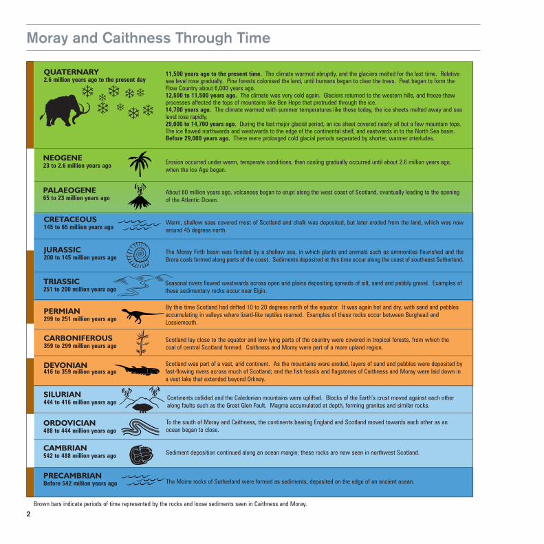
Moray and Caithness Through Time
CRETACEOUS145 to 65 million years ago
JURASSIC200 to 145 million years ago
PERMIAN299 to 251 million years ago
CARBONIFEROUS359 to 299 million years ago
About 60 million years ago, volcanoes began to erupt along the west coast of Scotland, eventually leading to the openingof the Atlantic Ocean.
Warm, shallow seas covered most of Scotland and chalk was deposited, but later eroded from the land, which was nowaround 45 degrees north.
The Moray Firth basin was flooded by a shallow sea, in which plants and animals such as ammonites flourished and theBrora coals formed along parts of the coast. Sediments deposited at this time occur along the coast of southeast Sutherland.
By this time Scotland had drifted 10 to 20 degrees north of the equator. It was again hot and dry, with sand and pebblesaccumulating in valleys where lizard-like reptiles roamed. Examples of these rocks occur between Burghead andLossiemouth.
Scotland lay close to the equator and low-lying parts of the country were covered in tropical forests, from which thecoal of central Scotland formed. Caithness and Moray were part of a more upland region.
TRIASSIC251 to 200 million years ago
Seasonal rivers flowed westwards across open arid plains depositing spreads of silt, sand and pebbly gravel. Examples ofthese sedimentary rocks occur near Elgin.
SILURIAN444 to 416 million years ago
DEVONIAN416 to 359 million years ago
ORDOVICIAN488 to 444 million years ago
Scotland was part of a vast, arid continent. As the mountains were eroded, layers of sand and pebbles were deposited byfast-flowing rivers across much of Scotland; and the fish fossils and flagstones of Caithness and Moray were laid down ina vast lake that extended beyond Orkney.
Continents collided and the Caledonian mountains were uplifted. Blocks of the Earth’s crust moved against each otheralong faults such as the Great Glen Fault. Magma accumulated at depth, forming granites and similar rocks.
To the south of Moray and Caithness, the continents bearing England and Scotland moved towards each other as anocean began to close.
11,500 years ago to the present time. The climate warmed abruptly, and the glaciers melted for the last time. Relativesea level rose gradually. Pine forests colonised the land, until humans began to clear the trees. Peat began to form theFlow Country about 6,000 years ago.12,500 to 11,500 years ago. The climate was very cold again. Glaciers returned to the western hills, and freeze-thawprocesses affected the tops of mountains like Ben Hope that protruded through the ice.14,700 years ago. The climate warmed with summer temperatures like those today, the ice sheets melted away and sealevel rose rapidly.29,000 to 14,700 years ago. During the last major glacial period, an ice sheet covered nearly all but a few mountain tops.The ice flowed northwards and westwards to the edge of the continental shelf, and eastwards in to the North Sea basin.Before 29,000 years ago. There were prolonged cold glacial periods separated by shorter, warmer interludes.
��
���
�
�
QUATERNARY2.6 million years ago to the present day
CAITHNESS AND MORAY THROUGH TIME
PALAEOGENE65 to 23 million years ago
CAMBRIAN542 to 488 million years ago Sediment deposition continued along an ocean margin; these rocks are now seen in northwest Scotland.
PRECAMBRIANBefore 542 million years ago The Moine rocks of Sutherland were formed as sediments, deposited on the edge of an ancient ocean.
Erosion occurred under warm, temperate conditions, then cooling gradually occurred until about 2.6 million years ago,when the Ice Age began.
NEOGENE23 to 2.6 million years ago
�
�
Brown bars indicate periods of time represented by the rocks and loose sediments seen in Caithness and Moray.

3
Geological Map of Moray and Caithness
PENTLAND FIRTH
Strathy Point
Bettyhill
Thurso
Duncansby Head
Wick
Morven Ben Klibreck
Helmsdale
MORAY FIRTH
Golspie
Dornoch
Dornoch Firth
Cromarty Cromart
y
Firth
Nairn
Elgin
20 Kilometres10 5 0
Jurassic sedimentaryrocks
Permian to Triassicsedimentary rocks
Devonian sedimentary rocks
Granite and otherigneous rocks
Dalradian meta-sedimentary rocks
Moine schists and gneisses
Older gneisses

4
The Ancient Rocks
The landscape of East Sutherland and Easter Ross is dominated by remote, rolling heather moorland, rising to broad mountain ridges such as Ben Hope, Ben Klibreck and Ben Wyvis. This landscape has barely changed since the ice age. Geologists working here in the early 20th century named the rocks of the area the Moine Schists, after the A’Mhoine peninsula on Sutherland’s north coast.
The Moine rocks formed almost 1,000 million years ago, when Scotland was part of an ancient continent that included Canada and Greenland. Sand and mud were eroded from a mountain range in Canada, then carried eastwards by fast-flowing rivers. Some sand and pebbles were deposited on the floodplains of these rivers as they approached the shore, whilst finer sand and mud were washed out to sea and deposited as sediment on the sea floor. Thick piles of these sea-floor sediments slowly accumulated and, over millions of years, turned into rocks under the pressure of burial. Eventually the supply of material eroded from the mountains dwindled, and deposition ceased.
The Moine rocks, though, are not the oldest rocks in Sutherland. In cliffs and crags along the coast around Bettyhill, it is possible to see slices of the rocks that made up the ancient continent upon which the Moine sediments were deposited. These are very ancient gneisses, possibly as much as 3,000 million years old. The gneisses are composed of distinctive, alternating dark- and pale-coloured bands, and this shows that they had a very complex history even before they were covered by the Moine sediments. Some particularly enigmatic gneisses can be seen in the crags around the Strathy Point lighthouse. At first glance they appear similar to the continental gneisses, but detailed study suggests that these rocks may actually represent a fragment of ancient ocean floor.
1The ridge of Ben Klibreck is formed of Moine rocks. 1

5

6
2The enigmatic rocks of the Strathy Complex form the cliffs around Strathy Point.
Following the formation of the Moine rocks, the next major geological event to affect this part of Scotland occurred around 600 million years ago, when a major ocean (the Iapetus Ocean) opened to the south of Scotland. A few isolated volcanoes may have erupted in Sutherland at that time. This ocean existed for over one hundred million years, and separated the continent that contained Scotland, Greenland and North America from another that included southern Europe, Africa and South America.

7
2

8
Colliding Continents and Mountain Building
Eventually, the Iapetus Ocean began to close, as the continent to the south moved steadily northwards. Some 470 million years ago, a chain of volcanic islands collided with the margin of the continent that contained Scotland, and this was followed 40 million years later by the collision of another continental mass that included England. These collisions thickened the Earth’s crust, forcing up the Caledonian mountain chain. The Moine rocks and the underlying gneisses were buried deep beneath the surface, where they were crumpled and folded. In places, huge masses of rock were thrust westwards over one another, bringing the older gneisses on top of the younger Moine rocks. Spectacular examples of Moine rocks twisted into complicated folds can be seen along the coast around Port Vasgo and Melness, on the west side of the Kyle of Tongue.
Deep beneath the mountains, the Moine rocks were heated and compressed. This led to the growth of new minerals within the rocks through the process of metamorphism. Some rocks were heated so much that they began to melt. However, because some minerals melt at lower temperatures than others, only some parts of the rock actually melted whilst other parts remained solid – just as, if you heated a Fruit and Nut bar in a saucepan, you would end up with solid nuts and raisins surrounded by melted chocolate. Some of these small amounts of molten rock (magma) simply cooled and crystallised again to produce veins of pale-coloured igneous rock within the metamorphosed Moine rocks. Rocks of this type are known as migmatites (from the Greek word for mixture), and they can be easily seen on the upper slopes of Ben Klibreck.
In some areas, molten rock flowed and collected to form progressively larger magma bodies. These bodies moved upwards through the crust, mixing along the way with other molten rock rising from greater depths in the Earth. Eventually these larger magma bodies began to cool again, and crystallised to form large masses of granite within the Moine rocks. Granites of this type are found in Helmsdale, on the northern side of Strath Fleet, and on the eastern side of Strath Halladale. These granites generally form low hills, and they contrast with the spectacular peak of Ben Loyal, which is formed of a different type of granitic rock derived solely from magma that rose up from deep within the Earth. All these bodies of igneous rock (rock formed from magma) are together known as Caledonian granites.
Laurentia
Scotland
Baltica
Gondwana
Volcanic Arc
Iapetus Ocean
Avalonia
500 million years agoAn ocean called Iapetus separated
Laurentia from the continents of Avalonia (including England and Wales) and Baltica (including Norway, Sweden and Finland). Slowly the continents converged and the ocean closed.
1The peaks of Ben Loyal, formed from an igneous rock called syenite, tower over the Kyle of Tongue.

9
1

10
2

11
2Layered Moine rocks at Port Vasgo. 3Folded layers of Moine rocks at Port Vasgo.
3

12
The Helmsdale Gold Rush
Gold was first discovered in the alluvium of Helmsdale in 1818, but it was not until 50 years later that Robert Gilchrist, a local man who had returned from the Australian gold fields, gained permission from the Duke of Sutherland to pan for gold in the River Helmsdale and its tributaries, the Kildonan and Suisgill burns. Within a year, there were some 600 prospectors in the area. They established the temporary settlement of Baile an Or, the ‘Town of Gold’, on the banks of the Kildonan Burn. The number of prospectors dwindled to some 200 after the Duke of Sutherland introduced a prospecting licence costing one pound. The gold rush ceased at the end of 1869, due to a combination of falling gold prices and complaints from local farmers, fishermen and sportsmen about the disturbance caused by the prospectors.
1Two metal pans used for retrieving gold from Kildonan Burn - pan on left 19th century, pan on right early 20th century. 2One Troy ounce (32 grams) of Kildonan Gold. 3Prospectors village at Baile an Or, Strath of Kildonan, around 1868.
21

13
3

14
3Baile an Or, Strath of Kildonan, site of the Helmsdale Gold Rush in the 1800s. This is how the site looks today, just like any other burn in the Highlands.
The original sources of the gold are thought to be veins cutting the Moine rocks and the Helmsdale granite. During the last ice age, erosion removed the gold from the veins and it became concentrated in the glacial sediments that mantle the Strath of Kildonan. Much of this gold was subsequently washed out of the glacial debris by rivers and streams and deposited as part of their alluvium, allowing the precious metal to accumulate in economic amounts.
The position of Baile an Or (Gaelic for the ‘Town of Gold’) is marked by an information board at the side of the A897 road at Kildonan. The board gives regulations governing panning for gold in the area today; recreational panning, within strict rules, is permitted free of charge along a stretch of the Kildonan Burn.

15
3

16
1Close-up of the course boulder conglomerate at Glen Loth. 2Glen Loth, showing a cliff composed of coarse boulder conglomerate laid down by raging rivers around 400 million years ago.
1
Raging Rivers and Shallow Lakes
After emplacement of the Caledonian granites, about 400 million years ago, much of northern Scotland was mountainous, hot and arid. Occasional torrential rainstorms battered the desert hills and ephemeral rivers deposited thick gravels and sands, often during flash floods like those that occur in North Africa today. These gravelly deposits now form rocks, known as conglomerates, which can be seen in the Old Red Sandstone mountains of Morven and Maidens Pap in the southern corner of Caithness.
Further downstream, the rivers laid down sand and silt and, as time passed, much of the river water accumulated to form Lake Orcadie, which extended from Moray across Caithness and Orkney to reach Greenland. The position of the shoreline of the lake fluctuated as the amount of rainfall varied, and as the lower-lying land sagged beneath the weight of the lake sediments as they accumulated. These lake sediments now form the Caithness flagstones and the rhythmic fluctuations
of the lake level and sediment supply are reflected in their finely-layered appearance. These Devonian flagstones are characteristic of much of the coastal scenery of the county.
17
2

18
3Fossils of fish that swam in Devonian Lake Orcadie in Caithness.
Algae bloomed in Lake Orcadie, providing an abundant source of food for primitive bony fish which swam up the rivers that drained from the lake into the sea. Many of the best fish fossils, for which Caithness is world famous, are found in beds of finely laminated limey mudstone or limestone, known as fish beds. These fish beds were laid down when the lake was at its deepest and most extensive. Many can be seen in the flagstone quarries that are a widespread feature of the Caithness landscape. The fish bed exposed in Achanarras quarry, south of the village of Halkirk, is the most famous; more than fifteen different types of fish have been found there, including predators that fed on those that grazed on the algae.
3

19
44

20
Silty Caithness flagstonesand fish beds
Crystalline rocks
Arid landscape of ancient gneisses
Alluvial plains with seasonal drainage
Sandy and siltyCaithness flagstones
Hills and mountains of granite and gneiss
Bouldery alluvial fans
LAKE ORCADIE
4The Orcadian Basin, where ancient fish swam in Lake Orcadie when it was at its deepest and most extensive. 5Cromarty, the former home of Hugh Miller and famous sea area on the BBC’s shipping forecast. 6Amber Hall from Cromarty Primary School holds a fossil of Diplacanthus Crassisimus which was found on Cromarty beach by Hugh Miller in around 1839.
4
Hugh Miller, one of Scotland’s most pre-eminent geologists, was born in 1802 in the village of Cromarty on the Black Isle, where his cottage is now a museum. He began his working life as an apprentice stone mason, and his appreciation of the local sandstones eventually led to his famous studies of the fossil fish of the Old Red Sandstone (a name he first coined for these rocks that is still used across the world today).
5

21
6

22
7

23
7Port à Chait, Tarbet Ness. The Devonian rocks can contain small fossilised fish remains.

24
Burying the Dead and Paving the World
Caithness flagstone has been used as building material since prehistoric times, when Neolithic man used it to construct brochs and burial mounds, such as the 5,500 year-old Camster Cairns near Watten. The layered structure of the flagstone allows it to be easily split, like slate, into thinner and thinner sheets. This means that it can be used for roofing and paving stones, as well as for the construction of buildings and walls; vertical slabs of flagstone are still used to produce the thin stone walls typical of the Caithness countryside. However, it is as paving-stone that the Caithness flagstone gained its world-wide importance.
During the 19th century, flagstone was quarried and shipped to all corners of the world, paving the far-off cities of Montevideo in South America and Sydney in Australia, as well as those of Britain and Europe. Much of the stone was dressed and exported from Castlehill, near Thurso, where the industry was begun by Sheriff James Traill and where
a flagstone Heritage Centre has now been set up. Flagstone is still actively quarried for high quality paving stones and polished Caithness flagstone has been used in the new Scottish Parliament building in Edinburgh.
1
1 and 2The neolithic Camster Cairns near Watten, Caithness.

25
2

26
2

27
2Caithness flagstone wall at Spittal, Caithness. 3The Atrium at Great Glen House, Inverness, the headquarters of Scottish Natural Heritage. The floor of the Atrium has been laid with Caithness flagstones. 4The Garden Lobby at the Scottish Parliament, Edinburgh, an informal meeting area for MSPs and their guests. The floor is constructed of Caithness flagstone interleaved with oak flooring areas.
4
3

28
The New Red Sandstone Desert
Between about 200 and 300 million years ago Scotland lay within the tropics. The climate was hot and dry, with ephemeral rivers depositing silt and sand on the arid plains and sand blown across the land to form huge sand dunes. The landscape probably resembled the present Sahara desert. In the Caithness and Moray area, sedimentary rocks of this ‘New Red Sandstone’ time are present beneath the waters of the Moray Firth, but onshore they occur only on the southern side of the firth near Elgin and on the northern side of the firth near Golspie.
Fossils and the walking tracks of reptiles are preserved in the dune sands that form the Hopeman and Lossiemouth Sandstones near Elgin. Bedding structures within these sandstones suggest that crescentic, star-shaped and ridge-like dunes, all typical of modern deserts, were present in the landscape. A great variety of reptiles inhabited the desert. They included crocodile-like and lizard-like animals that ate plants
and grubs, a kangaroo-like insect eater, and Britain’s oldest dinosaur, Saltopus elginensis, a small carnivore.
A fossil soil that formed under semi-arid conditions occurs on top of the New Red Sandstone rocks on both sides of the Moray Firth. The age of the reptile fossils found in the sandstones below the soil suggests that the hot desert conditions ended some 206 million years ago.
1The head of Elginia, a fossil reptile that stalked the Permian desert sands near Elgin. 2Layered sandstone at Clashach.
1

29
2

30
1Fossilised dinosaur tracks in sandstone blocks from Clashach Quarry near Hopeman. 2Layered sandstone and cave at Clashach near Hopeman.
1
2

31

32
Delta with vegetation
SW
Old Red Sandstoneconglomeratesand sandstones
Helmsdale granite
HELMSDALE FAULT
Shallow sea
Shallow sea
Jurassicshales
Caithness flagstones
Submarine scarp
NE
Swamps and Shallow Seas
The landscape of the New Red Sandstone desert disappeared beneath the waves when the Moray Firth basin was flooded by a shallow sea 200 million years ago. The more humid climate enabled woods and forests to cover the uplands to the west of the basin, whilst subsidence along the seaward side of large faults, such as the Helmsdale and Great Glen Faults, produced steep cliffs in older rocks along the basin margins. The sea cut away much of the lower lying ground, and shallow lagoons and vegetated swamps developed along the coast during this time, known as the Jurassic period. The coals of the Brora coalfield were formed when the decaying vegetation from these coastal swamps was buried beneath sands and silts of coastal rivers. The coal was first worked in 1598, when a pit was opened by the Countess of Sutherland; the last workings at Brora were abandoned in 1975.
1The boulder beds formed debris-fans at the mouths of submarine canyons, cut into cliffs of Devonian Old Red Sandstone during the Jurassic. 2Slump folding within the boulder bed at Kintradwell.
1

33
2
As the basin continued to subside, the cliffs themselves became submerged. Large submarine canyons formed beyond the mouths of rivers that drained the upland. Huge boulder fans were laid down into the deeper water at the canyon mouths. Typical of these fan deposits are
the Helmsdale Boulder Beds that occur along the coast between Kintradwell and Ord Point. These Boulder Beds commonly contain blocks of rock many metres in size. Most blocks are of Old Red Sandstone and some contain fish fossils. Finer-grained beds of silt and
sand, between the boulders, contain fragments of sea shells, ammonites and corals washed down into the canyons from the bed of the shallow warm sea that drowned the coastline.

34
3Remnant of the Helmsdale boulder beds at Kintradwell, deposited by an alluvial fan 200 million years ago. 3
Similar rocks to those of the Brora coalfield form the reservoir of the offshore Beatrice oilfield, whose production platforms can, on a clear day, be seen from the shore between Brora and Wick. The source of oil is thought to be bituminous rocks within the Caithness Flagstones, whereas, in other North Sea oilfields, both the source and reservoir rocks are of Jurassic age.
By about 145 million years ago, the Jurassic rocks were buried beneath sediments laid down in the warm tropical seas of the Cretaceous period. No Cretaceous rocks are seen in the onshore area, but their presence beneath the waters of the Moray Firth is known from small fragments of flint and chalk in sediments that were dragged onshore by ice from the Moray Firth during the Ice Age.

35

36
The Ice Age
The climate of Northern Europe cooled from about 7 million years ago, when the Greenland ice sheet began to form. Major ice sheets first advanced across the mid-latitude continents about 2.6 million years ago, but most onshore evidence of these early glaciations has been destroyed by subsequent glacial erosion. However, the presence of glacial sediments off the coast of northern Scotland shows that extensive ice sheets covered the mainland and reached out to sea several times.
The Ice Age has witnessed numerous cold, ‘glacial’ periods separated by much shorter, warmer ‘interglacials’ every 100,000 years or so, when the ice retreated and the climate of Scotland was broadly similar to the present day. Warmer intervals also occurred regularly during the glacial periods as a result of subtle changes in the Earth’s orbit and axis of tilt relative to the sun. The last
major glaciation of Scotland was at its peak about 22,000 years ago, when only the highest mountain tops, such as Ben Hope, Ben Hee and Ben Klibreck may have protruded above the ice surface. A high ice divide stretched along the mountains of the western seaboard from which ice generally flowed eastwards towards the Moray Firth, where it coalesced into a gigantic lobe.
1The margin of a present day glacier.

37
1

38
A sudden climatic warming occurred 14,700 years ago when summer temperatures rose to those of the present day, if not warmer. Glaciers retreated rapidly, and freshly exposed stony soils were soon colonised by pioneer vegetation (grasses, sedges, club mosses, ‘alpine’ herbs and dwarf willow), before a mosaic of juniper scrub, crowberry, heather, grassland and birch wood became established. However, it was a false dawn, for the climate soon cooled again, and by 12,650 years ago ice had begun to accumulate again in the western Highlands and small corrie glaciers developed in some of the highest mountains of Sutherland such as Ben Hope and Ben Loyal. The rest of northern Scotland had a dry, arctic climate similar to that of the tundra of Siberia and northern Canada today. This caused freeze-thaw, ‘periglacial’ processes such as frost-heaving and frost-shattering to occur. Boulders and soil crept down steep slopes to form distinctive lobes, and screes formed as frost-shattered rocks tumbled down cliffs.
2The glaciated mountain of Ben Loyal at the head of the Kyle of Tongue, viewed from Ben Hope, Sutherland. 2

39

40
The Glacial Legacy
The Ice Age has left an indelible imprint on the landscape of the district. It created the rugged and desolate beauty of Sutherland and Caithness. It has contributed immensely to the richness and diversity of the landscape, exemplified around Beauly, where the yellow and golden autumn hues of the birch and larch growing on gravelly glacial deposits can be breathtaking.
in the direction of final ice flow. These ice-moulded, ‘streamlined’ features are best observed when the sun is low in the sky. The source of the ice can also be determined from glacial erratics. These include large perched boulders of ‘foreign’ rock types, as well as stones within glacial deposits that have been carried by the ice from distant sources.
The direction that the ice flowed can be established from the orientation of ‘whale back’ shaped crags. Many have smooth, grooved, ice-abraded surfaces on one side and jagged, plucked surfaces on the other, which point towards where the ice was flowing. On lower ground, ridges and mounds of glacial debris deposited beneath the ice are commonly elongated
1Earth pillars at Fairy Glen Rosemarkie. These have formed where soft glacial sediments have been protected from erosion by the rain, by capstones of large perched boulders.

41
1

42
2Glacial meltwater channel in Strath Rory, Easter Ross. 3Glacial valley at Strath Cuil near Berriedale, Caithness.
The ice flowed over watersheds, scoured away loose and weathered rocks, and over-deepened, widened and straightened pre-existing valleys. The northern end of the Great Glen is a classic U-shaped glacial valley, as are Glen Urquhart and Strathglass. In northern Sutherland numerous ice-scoured hollows are now filled with water or peat, surrounded by ice-moulded crags. This ‘cnoc-and-lochan’ type of landscape is best developed between Bettyhill and Reay. Many arcuate,
boulder-strewn ridges occur within the corries and glaciated valleys of the Sutherland mountains. These formed when sediment was deposited at the glacier front to form moraines.
On the lower ground, the ice laid down smooth, very gently undulating sheets of rubbly glacial material called ‘till’. The extensive blankets of peat in Caithness and the Flow Country have formed largely on extremely compressed, clayey, poorly drained till. In contrast, the tills of Easter
Ross and around the Moray Firth tend to be more sandy and friable because they overlie sandstone, conglomerate and siltstone bedrock. Consequently, the soils developed on these sandy substrates provide relatively good agricultural land.
2

43
3

44
4Mounds of glacial gravel, and Glacial and Postglacial terraces near Drynachan, in the Findhorn Valley.
4

45

46
The Moray Firth Glacier
During the last major glaciation ice flowed into the Moray Firth from the mountains to the west and south-west via the Dornoch and Beauly Firths, and via the Great Glen. At an early stage, from about 28,000 to 22,000 years ago, Scottish ice was diverted across eastern Caithness and Buchan by Scandinavian ice that had flowed across the North Sea. This helps to explain why some of the tills of eastern Caithness and coastal Morayshire contain shells and large exotic masses of calcareous mud, rock and sand that had been ripped up by the Moray Firth glacier from the seabed. These ‘glacial rafts’ include fossil-bearing black mudstone, coaly material, white sand and shelly ‘greensand’. A very large raft of Cretaceous sandstone was formerly quarried at Leavad in eastern Caithness, and a large mass of highly fossiliferous Jurassic mudstone and limestone was worked for lime and brick-making at Linksfield, Elgin.
Later in the glaciation, after 22,000 years ago, Scandinavian ice yielded sufficiently to allow Scottish ice to flow out of the Moray Firth towards the Bosies Bank, an important fishing ground that represents the submerged terminal moraine of the glacier. By about 16,000 years ago ice in the Moray Firth had retreated to the vicinity of Elgin, before it shrank further into the inner firths to form separate glaciers. One of these glaciers occupied the Beauly Firth, from which it re-advanced towards Fort George, bulldozing sediments in front of it, to form a large ‘push moraine’ at its snout. It buckled some deposits of white, sandy silt that can be seen in abandoned cliffs behind Ardersier village. The silt is made of ‘rock flour’ that was derived from the grinding action of ice on hard, crystalline rock. It was released into the sea in
pulses of milky, glacial meltwater from the glacier snout. Individual beds of sand and silt in the Ardersier cliff sequence were first convoluted as the sediment settled, compacted and dewatered, and later the whole sequence was contorted into folds when it was pushed by the advancing glacier. The delicate lamination in the silt has been distorted into some remarkable shapes and structures like tear drops, balls and pillows.
The glacial re-advance at Ardersier occurred about 15,000 years ago. Whether it was a result of a global change in climate and sea level, or a local glacier surge is not known. However, on its retreat, the snout of the Beauly glacier clearly halted at Alturlie Point, where a large delta of outwash sand and gravel was deposited in the sea.
1

47
1Folding and ‘ball and pillow’ structures in the contorted silts of Ardersier. 2The Ardersier area from the air, showing the Lateglacial cliffline and the Flemington braided esker (bottom right). 3The Late Glacial cliff line and Holocene raised shoreline at Ardersier.
2
3

48
4The promontories of Chanonry Ness and Fort George, in the Moray Firth, have built up on top of push moraines of the Moray Firth Glacier.
4

49

50
Flemington Eskers
Vast quantities of water issued from retreating glaciers towards the end of the Ice Age. The source of the water included rainfall and seasonal snowmelt as well as thawing ice. Glacial debris was rolled, washed, sorted and transported in the water before being dumped in spreads of gravel, sand and silt. Such deposits are particularly widespread to the east of Inverness, towards Elgin, where they include networks of gravelly ridges called ‘eskers’ that wind around oddly-shaped, boggy hollows (‘kettle holes’). Kettle holes form when detached masses of glacier ice that were buried within, or beneath, the outwash deposits melted out, causing the gravels to collapse.
1Loch Flemington, a kettle loch near Nairn. 2The end of a meandering esker ridge at Flemington.
As the ice margin receded towards the Great Glen, meltwater flowed north-eastwards within a system of subglacial tunnels and ice-walled chasms, where it dumped deposits of sand and gravel. When the supporting ice eventually melted, networks of branching gravel
ridges were created. The Flemington Eskers, which are 5-10 metres high and stretch for about 8 kilometres to the east of Inverness airport towards Nairn, are an excellent example of such features. Loch Flemington occupies a large kettle hole within the ridges.
1

51
2

52
2Aerial view over the Kessock Bridge towards Inverness showing the delta at the mouth of the River Ness. 2
Eskers commonly interconnect with a chaotic assemblage of irregularly-shaped hummocks, winding ridges and mounds of sand and gravel. Many that have not been cultivated heavily support a rich diversity of herbs, birds, insects and small mammals. Sadly, eskers have often been quarried away to provide us with aggregate and building sand. The city of Inverness is largely built upon sand and gravel deposited at the snout of a glacier that occupied the Great Glen, but only the remnants of a 40 metres high esker that formed within the glacier can be seen beside the Caledonian Canal at Torvean and at Tomnahurich.

53
54
Ancient Shorelines
Global sea levels gradually rose when the continental ice sheets of the world began to melt towards the end of the Ice Age. This rise in sea level helped destabilise the ice sheet and, by about 16,000 years ago, the Moray Firth glacier had rapidly calved back to the coastline, as parts of the Antarctic ice shelves are doing today. Large deltas of sand and gravel formed where meltwater streams entered the sea and shingly beaches developed in favourable positions, particularly where the waves could easily erode gravelly glacial sediments. This happened while the surface of the land was still greatly depressed from the weight of the ice sheet and when sea level was 30 metres or more above the level of the sea today.
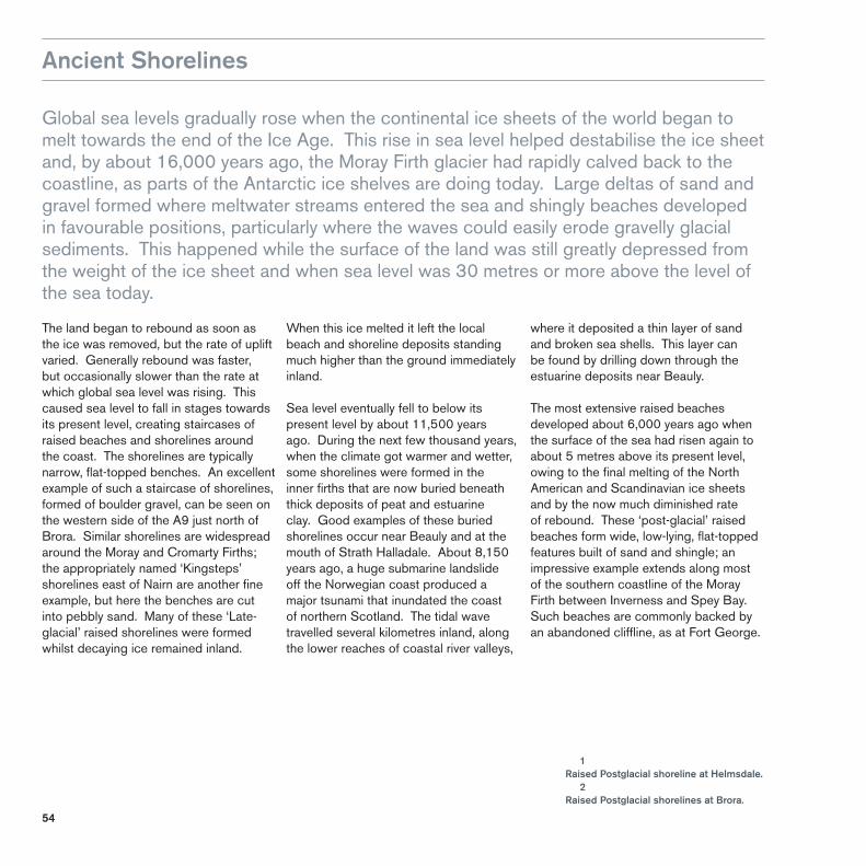
The land began to rebound as soon as the ice was removed, but the rate of uplift varied. Generally rebound was faster, but occasionally slower than the rate at which global sea level was rising. This caused sea level to fall in stages towards its present level, creating staircases of raised beaches and shorelines around the coast. The shorelines are typically narrow, flat-topped benches. An excellent example of such a staircase of shorelines, formed of boulder gravel, can be seen on the western side of the A9 just north of Brora. Similar shorelines are widespread around the Moray and Cromarty Firths; the appropriately named ‘Kingsteps’ shorelines east of Nairn are another fine example, but here the benches are cut into pebbly sand. Many of these ‘Late-glacial’ raised shorelines were formed whilst decaying ice remained inland.
1Raised Postglacial shoreline at Helmsdale. 2Raised Postglacial shorelines at Brora.
When this ice melted it left the local beach and shoreline deposits standing much higher than the ground immediately inland.
Sea level eventually fell to below its present level by about 11,500 years ago. During the next few thousand years, when the climate got warmer and wetter, some shorelines were formed in the inner firths that are now buried beneath thick deposits of peat and estuarine clay. Good examples of these buried shorelines occur near Beauly and at the mouth of Strath Halladale. About 8,150 years ago, a huge submarine landslide off the Norwegian coast produced a major tsunami that inundated the coast of northern Scotland. The tidal wave travelled several kilometres inland, along the lower reaches of coastal river valleys,
where it deposited a thin layer of sand and broken sea shells. This layer can be found by drilling down through the estuarine deposits near Beauly.
The most extensive raised beaches developed about 6,000 years ago when the surface of the sea had risen again to about 5 metres above its present level, owing to the final melting of the North American and Scandinavian ice sheets and by the now much diminished rate of rebound. These ‘post-glacial’ raised beaches form wide, low-lying, flat-topped features built of sand and shingle; an impressive example extends along most of the southern coastline of the Moray Firth between Inverness and Spey Bay. Such beaches are commonly backed by an abandoned cliffline, as at Fort George.

55
1
2

56

57
1Shingle spit at Spey Bay. 2Tsunami deposit in peat core from Barnyards, Black Isle. 1
2

58
After the Ice: the Flow Country
Profound changes in the landscape were brought about 11,500 years ago when the Ice Age came to an abrupt end and the present relatively warm, wet climate of northern Scotland dominated, by the Gulf Stream, became established. As the ground became freed from its icy burden, thin stony soils developed on the sediments laid down by the glaciers. These were first colonised by herbaceous plants, such as grasses and sedges, and then by shrubs such as heather, dwarf birch and juniper. Eventually, by about 8,000 years ago, birch scrubland was replaced by mixed woodland of birch, hazel, pine and oak.
Evidence for these changes in vegetation is found as pollen grains, seeds and plant fossils preserved in peat bogs that blanket much of the upland, and also in ancient lake sediments that accumulated in waterlogged depressions in the land surface. Thin layers of volcanic ash from volcanic eruptions in Iceland are also found in the peat in places, such as the Borrobol Forest, west of Helmsdale. The ashes were carried south-eastwards by the wind and, because the ashes form time-lines, their presence allows precise comparisons to be made between the types of vegetation that were growing at different places at the same time.
The Flow Country of Caithness and Sutherland owes its unique character to the accumulation of the largest expanse of blanket bogs in Europe that give the area its wild and apparently timeless solitude. In fact, the scenery is far from pristine, as much of the moorland was once wooded, as shown by the fossilised stumps of pine trees that are common in the peat. Much of this ancient forest cover was reduced by the activities of Mesolithic man who cleared the forests for agriculture and fuel. These clearances, together with a cooler and damper climate 6,000 years ago, led to the widespread development of the peat mosses.
1Blanket bog, of the Flow Country. 1

59

60
The Present Coastline
The remote coastline of Sutherland and Caithness has suffered relentless attack by the open sea ever since the last ice sheet melted. Little fishing villages such as Lybster and Dunbeath nestle within natural havens in long stretches of high, rugged cliffs, whereas the larger commercial ports of Wick and Scrabster have grown up around larger sheltered bays.
Dunnet Head, the northernmost headland facing the notoriously rough Pentland Firth, has a spectacular coastline of towering cliffs and treacherous reefs of Devonian flagstone and sandstone. Further west, at Strathy Point, the lighthouse warns sailors of sheer cliffs cut into more resistant metamorphic rocks.
The awesome power of waves has carved out deep caves and sea stacks, especially where cracks in the rock face the on-coming waves. A wave entering a crevice compresses air tightly. When the wave recedes, the compressed air expands violently, loosening rocks in the cliff wall and blowing out fragments until eventually a cave is formed. When two caves on opposite sides of a headland unite, a natural arch may be created, until it collapses and the seaward portion of
the headland becomes a sea stack. All of these features are widespread where cliffs of Caithness flagstone reach the sea. Fractures and crevices are common within the flagstones, and their layered structure is ideal for undermining by the sea to produce sheer cliffs, stacks and gently sloping wave-cut platforms. In some circumstances, the combined bombardment and blasting along fault planes in the flagstones has resulted in the creation of long, narrow tidal inlets called ‘geos’. More rarely, a vertical chimney or blowhole forms in the roof of a cave at the landward end of a geo, and during storms, sea spray is ejected forcibly through it. In some more sheltered spots, the near-horizontal layers have been etched out by the elements to provide resting places for important colonies of cliff-nesting seabirds.
1Old Red Sandstone sea cliffs at Whaligoe, Caithness. 1

61

62
2Sea stack in Devonian sandstones at Duncansby head, Caithess. 3Sea stacks and a natural arch at Duncansby Head, Caithness. 3
The coastline of the Moray Firth to the south of Helmsdale is more indented and varied. Intertidal mud flats and salt marshes have formed in the more tranquil environments at the heads of the inner firths, providing food for vast flocks of visiting wading birds, especially redshank, whooper swan and greylag and pink-footed geese. Sandy and pebbly beaches are developed on the less resistant Jurassic rocks between Helmsdale and Golspie, while steep cliffs follow the Great Glen Fault Zone north-east of Inverness.
2

63

64
4

65
4Culbin Bar. 5 Redshank. 6Greylang goose and goslings.
The southern shore of the Moray Firth, between Inverness and Burghead, is fringed by wide, raised beaches of shingle locally capped by blown sand. The River Findhorn carries unusually large quantities of sand and shingle to the coast. This is redistributed westwards by the waves before the sand is picked up by the prevailing wind to form a vast area of sand dunes up to 30 metres high at Culbin. These dunes, which overwhelmed the once fertile farmland and village of Culbin 300 years ago, have now been stabilised by the pine trees of Culbin Forest.
5
6

66
The Landscape Today
The landscape of northern Scotland today is a result of the presence of man in an area of very diverse geology and scenery, though the degree of man’s influence varies greatly. In the rugged uplands of Sutherland, for example, the effects of glaciation on the mountains dominate the form of the present landscape and, since prehistory, human influence has been largely limited to clearing the land for grazing, hunting and fishing. In more recent times, the growth of small crofting communities, the planting of forestry and the establishment of sporting estates have produced the tableau that we see now.
On the softer rocks that form much of Caithness and the coastal lowlands of Moray, human intervention is much more apparent. The better soils and more favourable climate have led to large-scale pastoral and arable farming, and natural harbours around the coast have provided
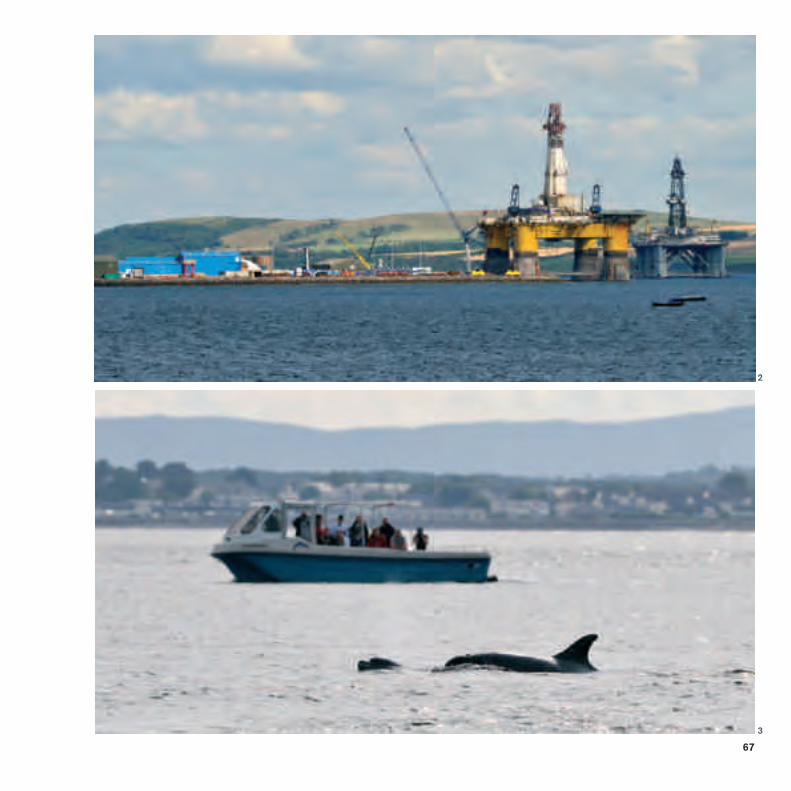
the sites for the growth of small towns and villages that began as fishing ports. In the 19th century, Wick was Europe’s largest herring fishing port. In its heyday, 1,000 fishing boats set sail every summer’s evening.
1Wick Harbour, showing the size of the 19th century fishing fleet. Fish-curing stations can be seen in the foreground. 2Oil rigs, Moray Firth. 3Dolphin watching, Moray Firth.
1
67
2
3

68
3The neolithic Clava Cairns, near Inverness. 4Commercial peat cutting near Spittal, Caithness. 4
The coastal areas have been the focus of human settlement since Neolithic times, as indicated by the numerous prehistoric sites such as the standing stone and chambered cairn at Cnoc na Maranaich, near Dunbeath, and the Bronze age Clava Cairns, near Culloden battlefield. For almost 400 years, between 800 and 1266 AD, Caithness was ruled by the Vikings, and many place names reflect this Norse heritage. The town of Thurso or ‘Thosa’ lies at the mouth of ‘Thor’s River’, whilst Wick, the county town, is derived from the Norse word for bay.
The mountainous interior of the region is now one of the most sparsely populated parts of Britain. The migration of the population from the hills to the coastal areas, and beyond, was hastened by the Highland Clearances; piles of stones and ancient peat cuttings are all that remains of many crofts and testify to the more numerous inland settlements of the past. In contrast, the city of Inverness and its dormitory towns such as Beauly and Nairn at the head of the Moray Firth, are a centre of population growth. The ‘Capital of the Highlands’ is the fastest growing city in Europe, and, with good road, rail and air links, it is becoming a major hub for tourism in the Highlands.
3

69

70
6Windfarm on peatland near Spittal, Caithness. 6
In the more rural areas, traditional whisky distilleries are still a prominent feature of the landscape. The industry is dependent on the pure water that percolates from the rocks and flows into the clear Highland burns. Newer industrial developments, such as wind farms, are now springing up. These take advantage of the windy climate to produce more energy than was gained by burning the peat from the moors on which many of the turbines are constructed. The influence of nearby offshore energy production from North Sea oil and gas is also evident, from the former rig building yards at Ardersier and Nigg to the presence of oil rigs moored in the Cromarty Firth.
All of these facets of modern and ancient development have produced the fascinating tapestry of cultural and natural landscapes of Caithness and Moray that are as varied as the rocks on which they are built.

71

72
Scottish Natural Heritage and the British Geological Survey
Scottish Natural Heritage is a government body. Its aim is to help people enjoy Scotland’s natural heritage responsibly, understand it more fully and use it wisely so it can be sustained for future generations.
Scottish Natural HeritageGreat Glen House, Leachkin Road,Inverness IV3 8NWt: 01463 725000e: [email protected]
The British Geological Survey maintains up-to-date knowledge of the geology of the UK and its continental shelf. It carries out surveys and geological research.
The Scottish Office of BGS is sited in Edinburgh. The office runs an advisory and information service, a geological library and a well-stocked geological bookshop.
British Geological Survey Murchison House West Mains Road Edinburgh EH9 3LAt : 0131 667 1000f : 0131 668 2683

73
Also in the Landscape Fashioned by Geology series...
Argyll and the IslandsDavid Stephenson & Jon MerrittISBN 1 978 85397 608 7Pbk 68pp £7.95
Arran and the Clyde IslandsDavid McAdam & Steve RobertsonISBN 1 85397 287 8Pbk 24pp £3.00
Ben Nevis and GlencoeKathryn Goodenough & David StephensonISBN 1 85397 506 6Pbk 44pp £4.95
CairngormsJohn Gordon, Rachel Wignall, Ness Brazier& Patricia BruneauISBN 1 85397 455 2Pbk 52pp £4.95
East Lothian and the BordersDavid McAdam & Phil StoneISBN 1 85397 242 8Pbk 26pp £3.00
Edinburgh and West LothianDavid McAdamISBN 1 85397 327 0Pbk 44pp £4.95
Fife and TaysideMike Browne, Alan McKirdy & David McAdamISBN 1 85397 110 3Pbk 36pp £3.95
Glasgow and AyrshireColin MacFadyen & John GordonISBN 1 85397 451 XPbk 52pp £4.95
Glen RoyDouglas Peacock, John Gordon & Frank MayISBN 1 85397 360 2Pbk 36pp £4.95
Loch Lomond to StirlingMike Browne & John MendumISBN 1 85397 119 7Pbk 26pp £2.00
Mull and IonaDavid StephensonISBN 1 85397 423 4Pbk 44pp £4.95
Northeast ScotlandJon Merritt & Graham LeslieISBN 978 1 85397 521 9Pbk 64pp £7.95
Northwest HighlandsJohn Mendum, Jon Merritt & Alan McKirdyISBN 1 85397 139 1Pbk 52pp £6.95
Orkney and ShetlandAlan McKirdyISBN 978 1 85397 602 5Pbk 68pp £7.95
The Outer HebridesKathryn Goodenough & Jon MerrittISBN 1 978 85397 507 3Pbk 36pp £4.95
Rum and the Small IslesKathryn Goodenough & Tom BradwellISBN 1 85397 370 2Pbk 48pp £5.95
Scotland: the creation of itsnatural landscapeAlan McKirdy & Roger CroftsISBN 1 85397 004 2Pbk 64pp £7.50
SkyeDavid Stephenson & Jon MerrittISBN 1 85397 026 3Pbk 24pp £3.95
Southwest ScotlandAndrew McMilland & Phil StoneISBN 978 1 85397 520 2Pbk 48pp £4.95
Series Editor: Alan McKirdy (SNH)
To order these and other publications, visit: www.snh.gov.uk