County Council's Report: Truancy in Montgomery County, Maryland

GEOTECHNICAL SUBSURFACE INVESTIGATION REPORT
Montgomery County Task Order #13 Montgomery County, Maryland
PREPARED FOR:
McCormick Taylor 509 South Exeter Street, 4th Floor
Baltimore, Maryland 21202
PREPARED BY:
AB CONSULTANTS, INC. 9450 ANNAPOLIS ROAD LANHAM, MARYLAND 20706
June 24, 2011
1500 So. Edgewood Street, #1600, Baltimore, Maryland 21227, Ph: (443) 524-2891; Fax: (443) 524-2897 3 La Grange Avenue,P.O. Box 1387, La Plata, Maryland 20646, Ph: (301) 538-4088; Fax: (301) 539-4950
Ph: (301) 306-3091 Fax: (301) 306-3092
www.abconsultantsinc.com Engineers Planners Surveyors Contractors
AB CONSULTANTS, INC. 9450 Annapolis Road Lanham, Maryland 20706
June 24, 2011 Attn: Ms. Kimi Schmidt McCormick Taylor 509 South Exeter Street, 4th Floor Baltimore, Maryland 21202 REF: Report of Subsurface Investigation and Studies Montgomery County Task Order #13 Roadway LID – Forest Estates & Four Corners Area Montgomery County, Maryland AB Job No. 10-368 Dear Ms. Schmidt: AB Consultants, Inc. (ABC) is pleased to submit this soil report containing the results of geotechnical investigation for the above referenced site. To obtain information of the subsurface condition, twenty-five (25) 10-ft deep soil borings were drilled and twenty-five (25) on-site infiltration tests were performed at the sites. The purpose of this study was to explore the subsurface conditions of this storm water management (SWM) improvement project. The following report sections discuss the results of field and laboratory studies, design recommendations and construction methods for the proposed structures. All samples obtained from soil test borings will be retained in our laboratory for a period of thirty (30) days from the date of this report. They will be available for inspection during this period. After that time, the samples will be discarded. It has been a pleasure serving you on this project. If you have any questions regarding this report, or if we can be of further service in any way, please contact us. Very truly yours, AB Consultants, Inc.
Kim-Hou Chan, P.E. Director, Geotechnical & Field Services
Geotechnical Report June 24, 2011 AB Job No.: 10-368 Page 1
AB CONSULTANTS, INC.
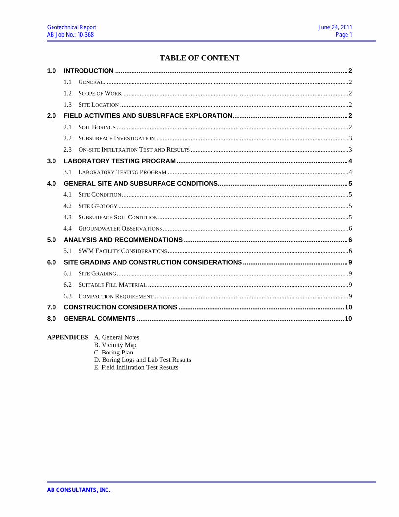
TABLE OF CONTENT 1.0 INTRODUCTION .................................................................................................................................2
1.1 GENERAL.....................................................................................................................................................2 1.2 SCOPE OF WORK .........................................................................................................................................2 1.3 SITE LOCATION ...........................................................................................................................................2
2.0 FIELD ACTIVITIES AND SUBSURFACE EXPLORATION................................................................2 2.1 SOIL BORINGS .............................................................................................................................................2 2.2 SUBSURFACE INVESTIGATION .....................................................................................................................3 2.3 ON-SITE INFILTRATION TEST AND RESULTS ................................................................................................3
3.0 LABORATORY TESTING PROGRAM...............................................................................................4 3.1 LABORATORY TESTING PROGRAM ..............................................................................................................4
4.0 GENERAL SITE AND SUBSURFACE CONDITIONS........................................................................5 4.1 SITE CONDITION..........................................................................................................................................5 4.2 SITE GEOLOGY ............................................................................................................................................5 4.3 SUBSURFACE SOIL CONDITION....................................................................................................................5 4.4 GROUNDWATER OBSERVATIONS.................................................................................................................6
5.0 ANALYSIS AND RECOMMENDATIONS ...........................................................................................6 5.1 SWM FACILITY CONSIDERATIONS..............................................................................................................6
6.0 SITE GRADING AND CONSTRUCTION CONSIDERATIONS ..........................................................9 6.1 SITE GRADING.............................................................................................................................................9 6.2 SUITABLE FILL MATERIAL ..........................................................................................................................9 6.3 COMPACTION REQUIREMENT ......................................................................................................................9
7.0 CONSTRUCTION CONSIDERATIONS ............................................................................................10 8.0 GENERAL COMMENTS ...................................................................................................................10 APPENDICES A. General Notes
B. Vicinity Map C. Boring Plan D. Boring Logs and Lab Test Results E. Field Infiltration Test Results

Geotechnical Report June 24, 2011 AB Job No.: 10-368 Page 2
AB CONSULTANTS, INC.
1.0 INTRODUCTION
1.1 General
This report summarizes the findings from subsurface soil investigations
conducted by ABC for the storm water management (SWM) improvement project located
in Montgomery County, Maryland. Per information provide to us, multiple Low Impact
Design SWM facilities are proposed on various streets in Montgomery County,
Maryland. The objective was accomplished by conducting field and laboratory tests.
The results of these tests constitute the bases for determining pertinent design parameters
for the proposed improvement. This study was conducted for McCormick Taylor and has
been performed in general accordance with our letter proposal dated on December, 2010
and subsequence conversations.
1.2 Scope of Work
The investigation of existing subsurface soil conditions at the site consisted of the
following:
• Planning and executing subsurface exploration programs to evaluate soil and
ground conditions for SWM improvements.
• Conducting on-site infiltration tests.
• Performing laboratory tests on soil samples obtained from the borings.
• Providing geotechnical report that includes results of field and laboratory studies.
1.3 Site Location
The field study was performed at various locations in Silver Spring, Montgomery
County, Maryland. Soil borings and infiltration test holes are located on Imperial Drive,
Woodman Avenue, Folk Street, Julep Avenue, Julep Court and Inwood Avenue.
2.0 FIELD ACTIVITIES AND SUBSURFACE EXPLORATION
2.1 Soil Borings
A total of twenty-five (25) soil borings were drilled for subsurface study on this
project site. Several more borings were canceled due to utilities conflicts or changes in
the scope of the project. Borings were drilled at the referenced site to depth of 10-ft
below the existing ground surface on May 31, June 11 to June 14, 2011. Soil borings

Geotechnical Report June 24, 2011 AB Job No.: 10-368 Page 3
AB CONSULTANTS, INC.
were staked out in the field by ABC. Site locations and boring plans are included in the
Appendix.
2.2 Subsurface Investigation
Borings were drilled using ATV-mounted drill rig, CME-55. Test borings were
advanced by using hollow-stem augers and soil samples were obtained using the Standard
Penetration Tests (SPT) in accordance with ASTM D1586. SPT samples were obtained
for each boring at depth intervals of every 2.5 feet. A representative portion of each split
spoon sample was placed in a glass jar and was transported to our laboratory.
In the split-barrel sampling procedure, a 2.0-inch O.D. split-barrel sampling spoon
is driven into the ground with a 140-pound hammer, free falling a distance of 30 inches.
The blows required to advance the sampling spoon to a specified distance are reported as
the penetration resistance values. The values are shown on boring logs at the depths of
their occurrence. The N-value is the sum of standard penetration resistance values that
advanced through the last 12-inches of sampling. The N-value is an indication of the
relative density of in-place granular soils and, to a lesser degree of accuracy, the
consistency of cohesive soils.
Groundwater level was monitored in the boring. Samples obtained from the
boring were inspected by a geotechnical engineer and the field logs were edited
accordingly. The final logs that indicate the subsurface conditions encountered are
included in the Appendix.
2.3 On-site Infiltration Test and Results
A total of twenty-five (25) infiltration tests were performed in auger borings
drilled at a 5-ft offset from the soil sample boring. Test holes were drilled with 8-inch
diameter auger to a depth of 2.5- to 6-ft below existing ground. 5-inch diameter solid
PVC casings were inserted and water was then introduced for an overnight presoak
period. Infiltration tests were performed the next day by refilling PVC casings with
water to the presoak level and then monitoring water levels at one hour intervals for four
hours. Field in-situ infiltration test data are included in the Appendix and results are
summarized as follows:

Geotechnical Report June 24, 2011 AB Job No.: 10-368 Page 4
AB CONSULTANTS, INC.
SUMMARY OF IN-SITU INFILTRATION TEST RESULTS Boring
No. Test Hole
Depth Existing
Elevation Sample Description at Bottom
of Test Hole Suggested Average
Infiltration Rate (in./hr) B-1 5.5 309.5 Silty fine sand 0.4 B-2 6 305 Silty fine sand 1.3 B-3 5.5 302 Silty fine sand 0.9 B-4 4.5 297.5 Silty fine sand 0.4 B-5 5 300 Silty fine sand 0.6 B-6 6 302 Clayey fine sand 0.1 B-7 2.5 302 Silty fine sand 0.55 B-8 5 297.5 Silty fine sand 1.0 B-9 - - Canceled* -
B-10 4.5 290.5 Clayey fine sand 0.4 B-11 6 293 Silty fine sand 2.45 B-12 - - Canceled* - B-13 - - Canceled* - B-14 4.5 317 Silty fine sand 0.95 B-15 2.5 301.5 Clayey fine sand 0.1 B-16 6.5 306 Clayey fine sand 0.3 B-17 6 313 Fine sandy clay 0.0 B-18 6 325 Fine sandy silt 0.95 B-19 5 320 Silty fine sand 7.1 B-20 5.5 333.5 Silty fine sand 0.5 B-21 5.5 333 Silty fine sand 1.3 B-22 2.5 330 Fine sandy silt 0.75 B-23 5.5 318.5 Silty fine sand 6.45 B-24 5.5 314.5 Silty fine sand 0.9 B-25 2.5 321 Silty fine sand 0.55 B-26 4.5 319 Silty fine sand 0.55 B-27 6 334 Silty fine sand 1.4 B-28 5.5 338.5 Silty fine sand 2.3
* Canceled due to utilities conflicts or change in the scope of the project.
3.0 LABORATORY TESTING PROGRAM
3.1 Laboratory Testing Program
Laboratory tests were performed on selected representative samples. Natural
moisture contents were performed on all soil samples, and results are included in boring
logs. Atterberg limits and sieve analysis were conducted on selected samples. Atterberg

Geotechnical Report June 24, 2011 AB Job No.: 10-368 Page 5
AB CONSULTANTS, INC.
limits results are shown in boring logs in correspondence with the sample depths and
results of sieve analyses are presented in the Appendix.
4.0 GENERAL SITE AND SUBSURFACE CONDITIONS
4.1 Site Condition
The SWM facilities are proposed on various streets in the Forest Estates
community in Silver Spring, Maryland. Borings on this project site are located in the
vicinity of single residential homes. Utilities in the vicinity of boring holes include
underground water, sewer and gas, cable and overhead power.
4.2 Site Geology
Geologically, the project site is in the Lower Pelitic Schist of the Eastern
Piedmont Metasedimentary Rocks Series of the Piedmont Plateau Province, which is
composed of hard, crystalline igneous and metamorphic rock. The major soils in this
association consist of medium- to coarse-grained biotite-oligoclase-muscovite-quartz
schist with garnet, staurolite, and kyanite; fine- to medium-grained semipelitic schist; and
fine-grained granular to weakly schistose psammitic granulite. Differential erosion of
these contrasting rock types has produced a distinctive topography in this part of the
Piedmont.
4.3 Subsurface Soil Condition
Various soil types were grouped into the major zones noted on the boring logs. A
brief explanation of the terms and notes used in the logs is included with this report. The
stratification lines designating the interfaces between earth materials on the boring logs are
approximate; in situ, the transitions may be gradual. Detailed soil description and depth of
various soil strata are given in boring logs, together with SPT blow counts with depth. In
general, the encountered soils are grouped and summarized as follows:
Topsoil: Topsoil was encountered in all boring. Topsoil is defined as the more high-
organic, weathered surficial soils horizon capable of supporting vegetation.
Type A Silty Fine Sand: Brown sandy soil with mica and trace of rock fragments
was encountered in most of boring and extended to completion depth of
borings. N-values in this layer were ranging from 4 to more than 50 blows

Geotechnical Report June 24, 2011 AB Job No.: 10-368 Page 6
AB CONSULTANTS, INC.
per foot. Some of the higher blow counts were due to the presence of rock
fragments in the layer.
Type B Clayey Fine sand to Fine Sandy Clay: Brown and gray clayey and sandy
soils with mica was encountered in borings B-6, B-15, B-16 and B-17 and
extended to completion depth of some borings. N-values in these soils
were ranging from 9 to more than 50 blows per foot. This clayey soil
exhibited low to moderate plasticity.
Type C Fine Sandy Silt: Reddish brown silty soil with mica was encountered in
boring B-10, B-18 and B-22 and extended to completion depth of some
borings. N-values in these soils were ranging from 6 to 30 blows per foot.
4.4 Groundwater Observations
Groundwater observations were made in every borehole during drilling, and after
completion of drilling operations. As noted on boring logs, groundwater was not
encountered in most borings during and after drilling. Water level observations are
presented at the lower left hand corner of boring logs. Fluctuations in the level and
quantity of ground water will occur due to variations in rainfall, temperature, soil
permeability and other factors not evident at the time of the water level measurements
recorded on boring logs.
5.0 ANALYSIS AND RECOMMENDATIONS
5.1 SWM Facility Considerations
Proposed plan or structural detail of the proposed SWM facilities were not
provided by the date of this report. Based upon the information provided from
McCormick Taylor, infiltration structures are considered in this project for storm water
management. Based on information revealed from borings, laboratory results, and our
visual classification of the recovered soil samples, the encountered subsoils are classified
per the USDA classification system and are summarized in the following table.

Geotechnical Report June 24, 2011 AB Job No.: 10-368 Page 7
AB CONSULTANTS, INC.
SUMMARY OF SOIL PROPERTIES PER USDA CLASSIFICATION
Boring No. Sample Depth (ft)
USDA Textural Classification
Minimum Infiltration Rate
(in/hr)
Hydrologic Soil Grouping
B-1 0.5 to 10 Loam 0.52 B B-2 0.5 to 10 Sandy loam 1.02 A B-3 0.5 to10 Sandy loam 1.02 A B-4 0.5 to10 Loam 0.52 B B-5 0.5 to 8 Loam 0.52 B B-6 0.5 to 4.5 Loam 0.52 B
4.5 to 10 Sandy clay loam 0.17 C B-7 0.5 to 5 Loam 0.52 B B-8 0.5 to 5 Sandy loam 1.02 A B-10 0.5 to 4 Loam 0.52 B
4 to 6.5 Sandy clay loam 0.17 C 6.5 to 10 Loam 0.52 B
B-11 0.5 to 6.5 Loamy sand 2.41 A 6.5 to 10 Sandy loam 1.02 A
B-14 0.5 to 10 Loam 0.52 B B-15 0.5 to 10 Sandy clay loam 0.17 C B-16 0.5 to 7.5 Sandy clay loam 0.17 C
7.5 to 10 Loam 0.52 B B-17 0.5 to 10 Sandy clay 0.05 D B-18 0.5 to 10 Loam 0.52 B B-19 0.5 to 7.5 Loamy sand 2.41 A
7.5 to 10 Loamy sand 2.41 A B-20 0.5 to 8 Loam 0.52 B
8 to 10 Loam 0.52 B B-21 0.5 to 10 Sandy loam 1.02 A B-22 0.5 to 10 Loam 0.52 B B-23 0.5 to 7.5 Loamy sand 2.41 A
7.5 to 10 Sandy loam 1.02 A B-24 0.5 to 10 Loam 0.52 B B-25 0.5 to 10 Loam 0.52 B B-26 0.5 to 10 Loam 0.52 B B-27 0.5 to 10 Sandy loam 1.02 A B-28 0.5 to 10 Sandy loam 1.02 A
The infiltration design criteria established by the Maryland Department of the
Environment (MDE) Water Management Administration advises that infiltration

Geotechnical Report June 24, 2011 AB Job No.: 10-368 Page 8
AB CONSULTANTS, INC.
practices are not recommended to be utilized: (a) in regions where the bottom of the
infiltration facility is in existing or newly placed fill, or (b) in materials that exhibit an
infiltration rates less than 0.52 inches per hour, or (c) where the groundwater table or
bedrock is within 4 feet of the bottom of the infiltration facility.
Considering the USDA classification, boring information, on-site infiltration tests
and groundwater observation, most of the proposed SWM areas are considered suitable
for infiltration design in accordance with general design criteria. Results of our findings
are summarized in the following table.
SUMMARY OF SWM CONSIDERATIONS AT 2.5- to 6-ft BELOW GROUND
Boring No.
Existing Elevation
Facility Bottom
Elevation
On-site Infiltration Rate (in/hr)
Infiltration Rate per
USDA (in/hr) Infiltration SWM Facility
B-1 309.5 304.2 0.4 0.52 Marginal* B-2 305 299.2 1.3 1.02 Acceptable B-3 302 296.5 0.9 1.02 Acceptable B-4 297.5 293.2 0.4 0.52 Marginal* B-5 300 294.9 0.6 0.52 Acceptable B-6 302 296.1 0.1 0.17 Not acceptable B-7 302 299.5 0.55 0.52 Acceptable B-8 297.5 292.4 1.0 1.02 Acceptable
B-10 290.5 285.8 0.4 0.17 Not acceptable B-11 293 287.0 2.45 2.41 Acceptable B-14 317 312.3 0.95 0.52 Acceptable B-15 301.5 299.0 0.1 0.17 Not acceptable B-16 306 299.7 0.3 0.17 Not acceptable B-17 313 307.1 0.0 0.05 Not acceptable B-18 325 318.9 0.95 0.52 Acceptable B-19 320 314.8 7.1 2.41 Acceptable B-20 333.5 327.9 0.5 0.52 Acceptable B-21 333 327.3 1.3 1.02 Acceptable B-22 330 327.5 0.75 0.52 Acceptable B-23 318.5 308.9 6.45 2.41 Acceptable B-24 314.5 308.9 0.9 0.52 Acceptable B-25 321 318.5 0.55 0.52 Acceptable B-26 319 314.6 0.55 0.52 Acceptable B-27 334 328.0 1.4 1.02 Acceptable B-28 338.5 332.8 2.3 1.02 Acceptable

Geotechnical Report June 24, 2011 AB Job No.: 10-368 Page 9
AB CONSULTANTS, INC.
It is recommended that during construction of the SWM facility, the soil
encountered at and below the planned elevation, to be verified along with their infiltration
characteristics.
6.0 SITE GRADING AND CONSTRUCTION CONSIDERATIONS
6.1 Site Grading
Grading preparation should include clearing within the limits of construction,
grubbing and removal of the organic surficial soils. The potential thickness of material
subject to stripping will vary from zero inches in grades areas without topsoil to six (6)
inches in other grass and wooded areas. Design and construction should include
provisions for temporary storage, hauling, and disposal of stripped materials at an
approved off-site location.
Following stripping, cutting, the subgrade should be verified prior to the
installation of SWM structures. Areas identified during the verification process as soft or
exhibiting “pumping” tendencies should be undercut, processed and recompacted or
removed and replaced with suitable fill, whichever is appropriate.
6.2 Suitable Fill Material
Fill and backfill for general areas should be free of organics and debris and rock
fragments in excess of 3-in. in any dimension. In the upper 18 inches of fill, maximum
particle size should be limited to about 1.5 inches. As per ASTM D2478 classification,
imported select fill should consist of sandy gravel (GM), clayey gravel (GC), gravelly
sand (SP), silty sand (SM), clayey sand (SC), or low-plasticity sandy clay (CL) with a
liquid limit and plasticity index of less than 40 and 15 respectively, or an approved
alternate.
6.3 Compaction Requirement
Fill soils should be compacted to a minimum of 95 percent of maximum Standard
Proctor dry density (ASTM D698), with a moisture content range of minus to plus 2
percent of optimum. Fill should be placed in a nominal 10-inch-thick loose lifts. Each
lift of fill should be properly compacted, tested and approved prior to placing subsequent
lifts.

Geotechnical Report June 24, 2011 AB Job No.: 10-368 Page 10
AB CONSULTANTS, INC.
7.0 CONSTRUCTION CONSIDERATIONS
Positive surface drainage should be established at the start of work, be maintained
during construction and following completion of the project to prevent surface water
ponding and subsequent saturation of subgrade soils. Prolonged exposure or saturation of
subgrade soils by ponding or runoff water may result in significant changes in strength
and compressibility characteristics. Saturated subgrade soils should be excavated and
replaced with suitable materials.
Depending upon weather conditions during and prior to construction, groundwater
may be encountered in the excavation areas. Any seepage into the construction
excavation could be controlled by pumping from sump pits. During site preparation,
surface runoff should be directed away from the construction areas.
8.0 GENERAL COMMENTS
The soil classifications presented in this report are based upon the data obtained
from the soil borings performed at indicated locations and from any other information
discussed in this report. This report does not reflect any variations that may occur across
the site. The nature and extent of such variations may not become evident until
construction. If variations appear evident, the conclusion and recommendations of this
report should then be reviewed by ABC geotechnical engineer in light of the new
information.
This report has been prepared for the exclusive use of our client for specific
application to the project discussed and has been prepared in accordance with generally
accepted geotechnical engineering practices. No other warranties, either expressed or
implied, are intended or made. In the event that any changes in the nature, design or
location of the project as outlined in this report are planned, the conclusions and
recommendations contained in this report shall not be considered valid unless the changes
are reviewed and the conclusions of this report modified or verified in writing by ABC
geotechnical engineer of record.
AB CONSULTANTS, INC.
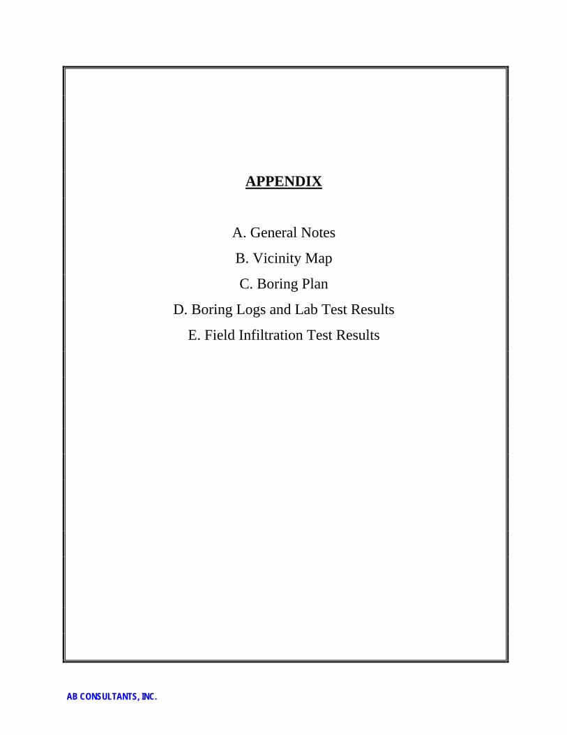
APPENDIX
A. General Notes
B. Vicinity Map
C. Boring Plan
D. Boring Logs and Lab Test Results
E. Field Infiltration Test Results
AB CONSULTANTS, INC.
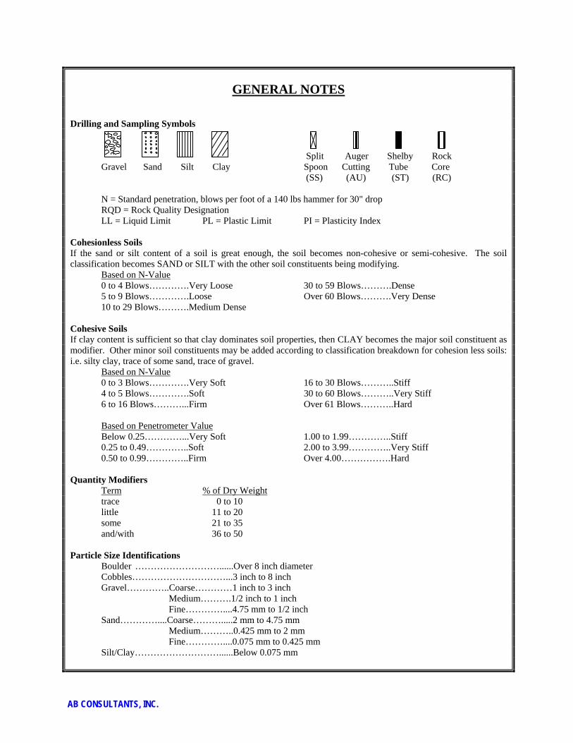
GENERAL NOTES Drilling and Sampling Symbols Split Auger Shelby Rock Gravel Sand Silt Clay Spoon Cutting Tube Core (SS) (AU) (ST) (RC) N = Standard penetration, blows per foot of a 140 lbs hammer for 30" drop RQD = Rock Quality Designation LL = Liquid Limit PL = Plastic Limit PI = Plasticity Index Cohesionless Soils If the sand or silt content of a soil is great enough, the soil becomes non-cohesive or semi-cohesive. The soil classification becomes SAND or SILT with the other soil constituents being modifying. Based on N-Value 0 to 4 Blows………….Very Loose 30 to 59 Blows……….Dense 5 to 9 Blows………….Loose Over 60 Blows……….Very Dense 10 to 29 Blows……….Medium Dense Cohesive Soils If clay content is sufficient so that clay dominates soil properties, then CLAY becomes the major soil constituent as modifier. Other minor soil constituents may be added according to classification breakdown for cohesion less soils: i.e. silty clay, trace of some sand, trace of gravel. Based on N-Value 0 to 3 Blows………….Very Soft 16 to 30 Blows………..Stiff 4 to 5 Blows………….Soft 30 to 60 Blows………..Very Stiff 6 to 16 Blows………...Firm Over 61 Blows………..Hard Based on Penetrometer Value Below 0.25…………...Very Soft 1.00 to 1.99…………..Stiff 0.25 to 0.49…………..Soft 2.00 to 3.99…………..Very Stiff 0.50 to 0.99…………..Firm Over 4.00…………….Hard Quantity Modifiers Term % of Dry Weight trace 0 to 10 little 11 to 20 some 21 to 35 and/with 36 to 50 Particle Size Identifications Boulder ………………………......Over 8 inch diameter Cobbles…………………………...3 inch to 8 inch Gravel…………..Coarse…………1 inch to 3 inch Medium……….1/2 inch to 1 inch Fine…………....4.75 mm to 1/2 inch Sand…………....Coarse……….....2 mm to 4.75 mm Medium………..0.425 mm to 2 mm Fine…………....0.075 mm to 0.425 mm Silt/Clay………………………......Below 0.075 mm
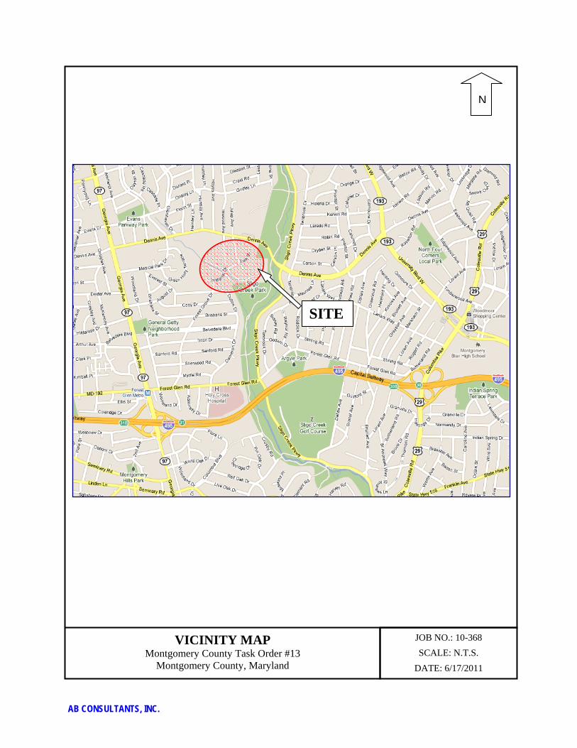
AB CONSULTANTS, INC.
VICINITY MAP Montgomery County Task Order #13
Montgomery County, Maryland
JOB NO.: 10-368
SCALE: N.T.S.
DATE: 6/17/2011
N
SITE
AB CONSULTANTS, INC.
BORING PLAN

!
!
!
!
!
!
!
!
!
!
!
!!
!
!
!
!
!
!
!
!
!
!
!
!
!!
!
!
!
!
WOODMAN AVE
INW
OO
D A
VE
FOLK ST
IMPERIAL DR
JU
LEP C
T
FOLK ST
DENNIS AVE
D
D
D
B-7
B-9
B-13B-12
B-25
B-22
B-8
B-4
B-6
B-5
B-3
B-2
B-1
B-19
B-28
B-11
B-16
B-20
B-21
B-15
B-17
B-18
B-24 B-26
B-27
B-23
B-10
B-14
B-19
B-11
B-17
0 50 100Feet
4Legend
! BMP Boring Locations
! Sidewalk Boring Locations

AB CONSULTANTS, INC.
BORING LOGS and LAB TEST RESULTS

5" TopsoilMedium dense brown SILTY FINE SAND (SM)with mica and rock fragments
-become loose between 5 to 7.5 ft
End of Boring @ 10 ft
Upon completion, borehole was backfilled.
6
15
19
13
0.4
10.0
6/1833%
12/1867%
15/1883%
12/1867%
SS
SS
SS
SS
1
2
3
4
38
309.1
299.5
4-8-8N=16
6-9-6N=15
2-2-2N=4
5-6-9N=15
5/31/11
B61
SURFACE ELEV.: 309.5 ft.
WATER LEVEL OBSERVATIONS
WL
WL
5/31/11
ABC
PS
AB Consultants, Inc.9450 Annapolis RoadLanham, MD 20706
Qu
(TS
F)%
PA
SS
ING
#200
SIE
VE
FINISHED:
DRILL RIG:
ASS'T DRILLER:
APPROVED:
SAMPLES
BLO
WS
/6"
N -
VA
LUE
RQ
D
TESTS
DR
Y D
EN
SIT
Y(P
CF)
NU
MB
ER
TYP
E
MO
ISTU
RE
(%)
Phone: 301-306-3091
McCormick Taylor
Project No. 10-368CLIENT:
ARCHITECT/ENGINEER:
Sheet 1 of 1
Dry
Dry, caved in 8 ft
STARTED:
DRILL CO.:
DRILLER:
LOGGED BY:Fax: 301-306-3092
LOG OF BOREHOLE B-01
RE
MA
RK
S/
AD
DIT
ION
AL
DA
TA
@ Drilling
@ 0 hr
IN. R
EC
OV
ER
ED
IN. D
RIV
EN
PROJECT:MO County Task #13
MO County, MarylandSITE:
DE
PTH
(FT)
GR
AP
HIC
LO
G
5
10
BO
RIN
G L
OG
AB
09 1
0-36
8 M
O C
OU
NTY
TA
SK
#13
.GP
J A
B_C
ON
S.G
DT
6/2
4/11
3" TopsoilMedium dense brown SILTY FINE SAND (SM)with mica
End of Boring @ 10 ft
Upon completion, borehole was backfilled.
7
13
29
11
0.2
10.0
18/18100%
18/18100%
18/18100%
18/18100%
SS
SS
SS
SS
1
2
3
4
13
304.8
295.0
6-7-9N=16
4-4-8N=12
3-3-8N=11
6-8-12N=20
6/11/11
CME 55
SURFACE ELEV.: 305.0 ft.
WATER LEVEL OBSERVATIONS
WL
WL
6/11/11
ABC
AR
AB Consultants, Inc.9450 Annapolis RoadLanham, MD 20706
Qu
(TS
F)%
PA
SS
ING
#200
SIE
VE
FINISHED:
DRILL RIG:
ASS'T DRILLER:
APPROVED:
SAMPLES
BLO
WS
/6"
N -
VA
LUE
RQ
D
TESTS
DR
Y D
EN
SIT
Y(P
CF)
NU
MB
ER
TYP
E
MO
ISTU
RE
(%)
Phone: 301-306-3091
McCormick Taylor
Project No. 10-368CLIENT:
ARCHITECT/ENGINEER:
Sheet 1 of 1
Dry
Dry, caved in 4 ft
STARTED:
DRILL CO.:
DRILLER:
LOGGED BY:Fax: 301-306-3092
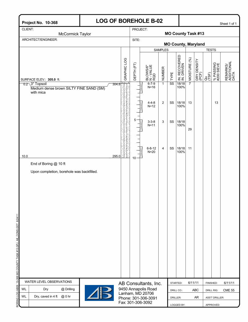
LOG OF BOREHOLE B-02
RE
MA
RK
S/
AD
DIT
ION
AL
DA
TA
@ Drilling
@ 0 hr
IN. R
EC
OV
ER
ED
IN. D
RIV
EN
PROJECT:MO County Task #13
MO County, MarylandSITE:
DE
PTH
(FT)
GR
AP
HIC
LO
G
5
10
BO
RIN
G L
OG
AB
09 1
0-36
8 M
O C
OU
NTY
TA
SK
#13
.GP
J A
B_C
ON
S.G
DT
6/2
4/11

2" TopsoilDense to very dense brown SILTY FINE SAND(SM) with rock fragments and mica
End of Boring @ 10 ft
Upon completion, borehole was backfilled.
4
9
13
7
0.1
10.0
18/18100%
12/12100%
12/1675%
8/1267%
SS
SS
SS
SS
1
2
3
4
15
301.9
292.0
10-18-21N=39
25-50/6"
25-36-50/4"
27-50/5"
6/11/11
CME 55
SURFACE ELEV.: 302.0 ft.
WATER LEVEL OBSERVATIONS
WL
WL
6/11/11
ABC
AR
AB Consultants, Inc.9450 Annapolis RoadLanham, MD 20706
Qu
(TS
F)%
PA
SS
ING
#200
SIE
VE
FINISHED:
DRILL RIG:
ASS'T DRILLER:
APPROVED:
SAMPLES
BLO
WS
/6"
N -
VA
LUE
RQ
D
TESTS
DR
Y D
EN
SIT
Y(P
CF)
NU
MB
ER
TYP
E
MO
ISTU
RE
(%)
Phone: 301-306-3091
McCormick Taylor
Project No. 10-368CLIENT:
ARCHITECT/ENGINEER:
Sheet 1 of 1
Dry
Dry, caved in 4 ft
STARTED:
DRILL CO.:
DRILLER:
LOGGED BY:Fax: 301-306-3092
LOG OF BOREHOLE B-03
RE
MA
RK
S/
AD
DIT
ION
AL
DA
TA
@ Drilling
@ 0 hr
IN. R
EC
OV
ER
ED
IN. D
RIV
EN
PROJECT:MO County Task #13
MO County, MarylandSITE:
DE
PTH
(FT)
GR
AP
HIC
LO
G
5
10
BO
RIN
G L
OG
AB
09 1
0-36
8 M
O C
OU
NTY
TA
SK
#13
.GP
J A
B_C
ON
S.G
DT
6/2
4/11

2" TopsoilDense to medium dense brown SILTY FINESAND (SM) with mica
-become loose between 2.5 to 5 ft
End of Boring @ 10 ft
Upon completion, borehole was backfilled.
4
6
24
5
0.1
10.0
14/1878%
18/18100%
12/1867%
12/1867%
SS
SS
SS
SS
1
2
3
4
46
297.4
287.5
6-15-35N=50
3-5-2N=7
5-6-8N=14
26-16-11N=27
6/11/11
CME 55
SURFACE ELEV.: 297.5 ft.
WATER LEVEL OBSERVATIONS
WL
WL
6/11/11
ABC
AR
AB Consultants, Inc.9450 Annapolis RoadLanham, MD 20706
Qu
(TS
F)%
PA
SS
ING
#200
SIE
VE
FINISHED:
DRILL RIG:
ASS'T DRILLER:
APPROVED:
SAMPLES
BLO
WS
/6"
N -
VA
LUE
RQ
D
TESTS
DR
Y D
EN
SIT
Y(P
CF)
NU
MB
ER
TYP
E
MO
ISTU
RE
(%)
Phone: 301-306-3091
McCormick Taylor
Project No. 10-368CLIENT:
ARCHITECT/ENGINEER:
Sheet 1 of 1
Dry
Dry, caved in 5.5 ft
STARTED:
DRILL CO.:
DRILLER:
LOGGED BY:Fax: 301-306-3092
LOG OF BOREHOLE B-04
RE
MA
RK
S/
AD
DIT
ION
AL
DA
TA
@ Drilling
@ 0 hr
IN. R
EC
OV
ER
ED
IN. D
RIV
EN
PROJECT:MO County Task #13
MO County, MarylandSITE:
DE
PTH
(FT)
GR
AP
HIC
LO
G
5
10
BO
RIN
G L
OG
AB
09 1
0-36
8 M
O C
OU
NTY
TA
SK
#13
.GP
J A
B_C
ON
S.G
DT
6/2
4/11

3" TopsoilMedium dense brown and gray SILTY FINESAND (SM) with mica
End of Boring @ 10 ft
Upon completion, borehole was backfilled.
8
16
22
28
0.2
10.0
8/1844%
12/1867%
8/1844%
18/18100%
SS
SS
SS
SS
1
2
3
4
41
299.8
290.0
15-8-6N=14
12-10-11N=21
6-7-12N=19
2-3-4N=7
6/11/11
CME 55
SURFACE ELEV.: 300.0 ft.
WATER LEVEL OBSERVATIONS
WL
WL
6/11/11
ABC
AR
AB Consultants, Inc.9450 Annapolis RoadLanham, MD 20706
Qu
(TS
F)%
PA
SS
ING
#200
SIE
VE
FINISHED:
DRILL RIG:
ASS'T DRILLER:
APPROVED:
SAMPLES
BLO
WS
/6"
N -
VA
LUE
RQ
D
TESTS
DR
Y D
EN
SIT
Y(P
CF)
NU
MB
ER
TYP
E
MO
ISTU
RE
(%)
Phone: 301-306-3091
McCormick Taylor
Project No. 10-368CLIENT:
ARCHITECT/ENGINEER:
Sheet 1 of 1
Dry
Dry, caved in 5 ft
STARTED:
DRILL CO.:
DRILLER:
LOGGED BY:Fax: 301-306-3092
LOG OF BOREHOLE B-05
RE
MA
RK
S/
AD
DIT
ION
AL
DA
TA
@ Drilling
@ 0 hr
IN. R
EC
OV
ER
ED
IN. D
RIV
EN
PROJECT:MO County Task #13
MO County, MarylandSITE:
DE
PTH
(FT)
GR
AP
HIC
LO
G
5
10
BO
RIN
G L
OG
AB
09 1
0-36
8 M
O C
OU
NTY
TA
SK
#13
.GP
J A
B_C
ON
S.G
DT
6/2
4/11

2" TopsoilMedium dense brown SILTY FINE SAND (SM)with mica
Medium dense gray and tan CLAYEY FINESAND (SC) with mica
End of Boring @ 10 ft
Upon completion, borehole was backfilled.
11
18
33
22
0.1
4.5
10.0
6/1833%
18/18100%
12/1867%
12/1867%
SS
SS
SS
SS
1
2
3
4 LL = 37PL = 25PI = 12
47
301.9
297.5
292.0
8-6-5N=11
8-10-12N=22
4-4-13N=17
4-4-8N=12
6/11/11
CME 55
SURFACE ELEV.: 302.0 ft.
WATER LEVEL OBSERVATIONS
WL
WL
6/11/11
ABC
AR
AB Consultants, Inc.9450 Annapolis RoadLanham, MD 20706
Qu
(TS
F)%
PA
SS
ING
#200
SIE
VE
FINISHED:
DRILL RIG:
ASS'T DRILLER:
APPROVED:
SAMPLES
BLO
WS
/6"
N -
VA
LUE
RQ
D
TESTS
DR
Y D
EN
SIT
Y(P
CF)
NU
MB
ER
TYP
E
MO
ISTU
RE
(%)
Phone: 301-306-3091
McCormick Taylor
Project No. 10-368CLIENT:
ARCHITECT/ENGINEER:
Sheet 1 of 1
Dry
Dry, caved in 5 ft
STARTED:
DRILL CO.:
DRILLER:
LOGGED BY:Fax: 301-306-3092
LOG OF BOREHOLE B-06
RE
MA
RK
S/
AD
DIT
ION
AL
DA
TA
@ Drilling
@ 0 hr
IN. R
EC
OV
ER
ED
IN. D
RIV
EN
PROJECT:MO County Task #13
MO County, MarylandSITE:
DE
PTH
(FT)
GR
AP
HIC
LO
G
5
10
BO
RIN
G L
OG
AB
09 1
0-36
8 M
O C
OU
NTY
TA
SK
#13
.GP
J A
B_C
ON
S.G
DT
6/2
4/11

2" TopsoilMedium dense brown SILTY FINE SAND (SM)
End of Boring @ 5 ft
Upon completion, borehole was backfilled.
21
10
3
0.1
5.0
12/1867%
18/18100%
4/1822%
SS
SS
SS
1
2
3
43
301.9
297.0
6-6-7N=13
7-7-11N=18
11-6-6N=12
6/11/11
CME 55
SURFACE ELEV.: 302.0 ft.
WATER LEVEL OBSERVATIONS
WL
WL
6/11/11
ABC
AR
AB Consultants, Inc.9450 Annapolis RoadLanham, MD 20706
Qu
(TS
F)%
PA
SS
ING
#200
SIE
VE
FINISHED:
DRILL RIG:
ASS'T DRILLER:
APPROVED:
SAMPLES
BLO
WS
/6"
N -
VA
LUE
RQ
D
TESTS
DR
Y D
EN
SIT
Y(P
CF)
NU
MB
ER
TYP
E
MO
ISTU
RE
(%)
Phone: 301-306-3091
McCormick Taylor
Project No. 10-368CLIENT:
ARCHITECT/ENGINEER:
Sheet 1 of 1
Dry
Dry, caved in 2.5 ft
STARTED:
DRILL CO.:
DRILLER:
LOGGED BY:Fax: 301-306-3092
LOG OF BOREHOLE B-07
RE
MA
RK
S/
AD
DIT
ION
AL
DA
TA
@ Drilling
@ 0 hr
IN. R
EC
OV
ER
ED
IN. D
RIV
EN
PROJECT:MO County Task #13
MO County, MarylandSITE:
DE
PTH
(FT)
GR
AP
HIC
LO
G
5
BO
RIN
G L
OG
AB
09 1
0-36
8 M
O C
OU
NTY
TA
SK
#13
.GP
J A
B_C
ON
S.G
DT
6/2
4/11

1" TopsoilMedium dense brown SILTY FINE SAND (SM)
End of Boring @ 10 ft
Upon completion, borehole was backfilled.
19
14
17
25
0.1
10.0
12/1867%
12/1867%
10/1856%
8/1844%
SS
SS
SS
SS
1
2
3
4
25
297.4
287.5
6-6-8N=14
6-8-8N=16
14-10-12N=22
6-6-8N=14
6/11/11
CME 55
SURFACE ELEV.: 297.5 ft.
WATER LEVEL OBSERVATIONS
WL
WL
6/11/11
ABC
AR
AB Consultants, Inc.9450 Annapolis RoadLanham, MD 20706
Qu
(TS
F)%
PA
SS
ING
#200
SIE
VE
FINISHED:
DRILL RIG:
ASS'T DRILLER:
APPROVED:
SAMPLES
BLO
WS
/6"
N -
VA
LUE
RQ
D
TESTS
DR
Y D
EN
SIT
Y(P
CF)
NU
MB
ER
TYP
E
MO
ISTU
RE
(%)
Phone: 301-306-3091
McCormick Taylor
Project No. 10-368CLIENT:
ARCHITECT/ENGINEER:
Sheet 1 of 1
Dry
Dry, caved in 5 ft
STARTED:
DRILL CO.:
DRILLER:
LOGGED BY:Fax: 301-306-3092
LOG OF BOREHOLE B-08
RE
MA
RK
S/
AD
DIT
ION
AL
DA
TA
@ Drilling
@ 0 hr
IN. R
EC
OV
ER
ED
IN. D
RIV
EN
PROJECT:MO County Task #13
MO County, MarylandSITE:
DE
PTH
(FT)
GR
AP
HIC
LO
G
5
10
BO
RIN
G L
OG
AB
09 1
0-36
8 M
O C
OU
NTY
TA
SK
#13
.GP
J A
B_C
ON
S.G
DT
6/2
4/11
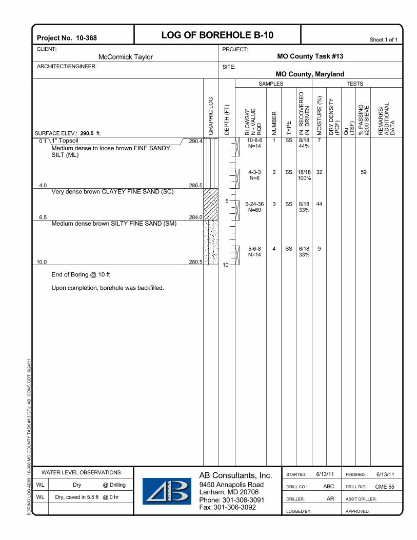
1" TopsoilMedium dense to loose brown FINE SANDYSILT (ML)
Very dense brown CLAYEY FINE SAND (SC)
Medium dense brown SILTY FINE SAND (SM)
End of Boring @ 10 ft
Upon completion, borehole was backfilled.
7
32
44
9
0.1
4.0
6.5
10.0
8/1844%
18/18100%
6/1833%
6/1833%
SS
SS
SS
SS
1
2
3
4
59
290.4
286.5
284.0
280.5
10-8-6N=14
4-3-3N=6
6-24-36N=60
5-6-8N=14
6/13/11
CME 55
SURFACE ELEV.: 290.5 ft.
WATER LEVEL OBSERVATIONS
WL
WL
6/13/11
ABC
AR
AB Consultants, Inc.9450 Annapolis RoadLanham, MD 20706
Qu
(TS
F)%
PA
SS
ING
#200
SIE
VE
FINISHED:
DRILL RIG:
ASS'T DRILLER:
APPROVED:
SAMPLES
BLO
WS
/6"
N -
VA
LUE
RQ
D
TESTS
DR
Y D
EN
SIT
Y(P
CF)
NU
MB
ER
TYP
E
MO
ISTU
RE
(%)
Phone: 301-306-3091
McCormick Taylor
Project No. 10-368CLIENT:
ARCHITECT/ENGINEER:
Sheet 1 of 1
Dry
Dry, caved in 5.5 ft
STARTED:
DRILL CO.:
DRILLER:
LOGGED BY:Fax: 301-306-3092
LOG OF BOREHOLE B-10
RE
MA
RK
S/
AD
DIT
ION
AL
DA
TA
@ Drilling
@ 0 hr
IN. R
EC
OV
ER
ED
IN. D
RIV
EN
PROJECT:MO County Task #13
MO County, MarylandSITE:
DE
PTH
(FT)
GR
AP
HIC
LO
G
5
10
BO
RIN
G L
OG
AB
09 1
0-36
8 M
O C
OU
NTY
TA
SK
#13
.GP
J A
B_C
ON
S.G
DT
6/2
4/11
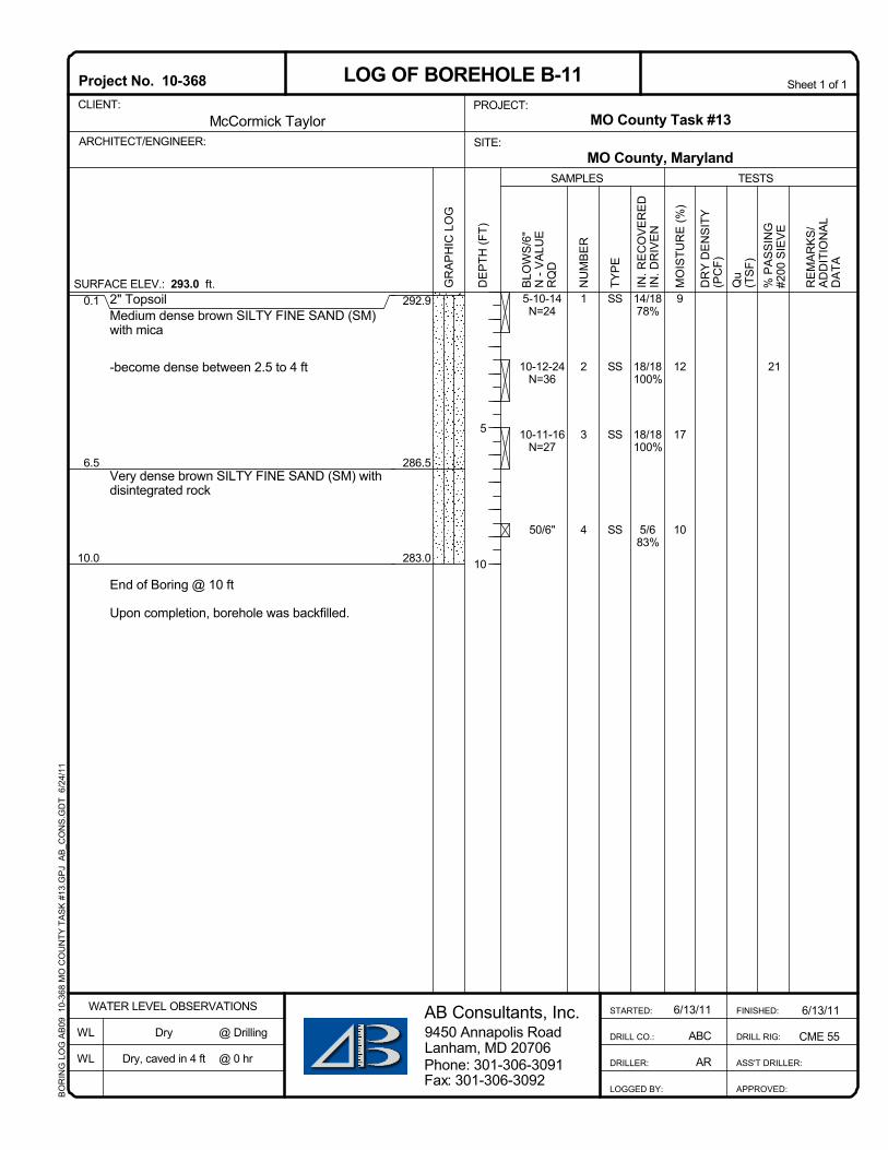
2" TopsoilMedium dense brown SILTY FINE SAND (SM)with mica
-become dense between 2.5 to 4 ft
Very dense brown SILTY FINE SAND (SM) withdisintegrated rock
End of Boring @ 10 ft
Upon completion, borehole was backfilled.
9
12
17
10
0.1
6.5
10.0
14/1878%
18/18100%
18/18100%
5/683%
SS
SS
SS
SS
1
2
3
4
21
292.9
286.5
283.0
5-10-14N=24
10-12-24N=36
10-11-16N=27
50/6"
6/13/11
CME 55
SURFACE ELEV.: 293.0 ft.
WATER LEVEL OBSERVATIONS
WL
WL
6/13/11
ABC
AR
AB Consultants, Inc.9450 Annapolis RoadLanham, MD 20706
Qu
(TS
F)%
PA
SS
ING
#200
SIE
VE
FINISHED:
DRILL RIG:
ASS'T DRILLER:
APPROVED:
SAMPLES
BLO
WS
/6"
N -
VA
LUE
RQ
D
TESTS
DR
Y D
EN
SIT
Y(P
CF)
NU
MB
ER
TYP
E
MO
ISTU
RE
(%)
Phone: 301-306-3091
McCormick Taylor
Project No. 10-368CLIENT:
ARCHITECT/ENGINEER:
Sheet 1 of 1
Dry
Dry, caved in 4 ft
STARTED:
DRILL CO.:
DRILLER:
LOGGED BY:Fax: 301-306-3092
LOG OF BOREHOLE B-11
RE
MA
RK
S/
AD
DIT
ION
AL
DA
TA
@ Drilling
@ 0 hr
IN. R
EC
OV
ER
ED
IN. D
RIV
EN
PROJECT:MO County Task #13
MO County, MarylandSITE:
DE
PTH
(FT)
GR
AP
HIC
LO
G
5
10
BO
RIN
G L
OG
AB
09 1
0-36
8 M
O C
OU
NTY
TA
SK
#13
.GP
J A
B_C
ON
S.G
DT
6/2
4/11

1" TopsoilMedium dense brown SILTY FINE SAND (SM)
End of Boring @ 10 ft
Upon completion, borehole was backfilled.
6
9
15
16
0.1
10.0
12/1867%
12/1867%
10/1856%
8/1844%
SS
SS
SS
SS
1
2
3
4
32
316.9
307.0
6-7-10N=17
4-10-11N=21
9-9-13N=22
4-5-8N=13
6/13/11
CME 55
SURFACE ELEV.: 317.0 ft.
WATER LEVEL OBSERVATIONS
WL
WL
6/13/11
ABC
AR
AB Consultants, Inc.9450 Annapolis RoadLanham, MD 20706
Qu
(TS
F)%
PA
SS
ING
#200
SIE
VE
FINISHED:
DRILL RIG:
ASS'T DRILLER:
APPROVED:
SAMPLES
BLO
WS
/6"
N -
VA
LUE
RQ
D
TESTS
DR
Y D
EN
SIT
Y(P
CF)
NU
MB
ER
TYP
E
MO
ISTU
RE
(%)
Phone: 301-306-3091
McCormick Taylor
Project No. 10-368CLIENT:
ARCHITECT/ENGINEER:
Sheet 1 of 1
Dry
Dry, caved in 4 ft
STARTED:
DRILL CO.:
DRILLER:
LOGGED BY:Fax: 301-306-3092
LOG OF BOREHOLE B-14
RE
MA
RK
S/
AD
DIT
ION
AL
DA
TA
@ Drilling
@ 0 hr
IN. R
EC
OV
ER
ED
IN. D
RIV
EN
PROJECT:MO County Task #13
MO County, MarylandSITE:
DE
PTH
(FT)
GR
AP
HIC
LO
G
5
10
BO
RIN
G L
OG
AB
09 1
0-36
8 M
O C
OU
NTY
TA
SK
#13
.GP
J A
B_C
ON
S.G
DT
6/2
4/11

2" TopsoilMedium dense to dense brown CLAYEY FINESAND (SC) with trace of organic
-with more gravel below 8 ft
End of Boring @ 10 ft
Upon completion, borehole was backfilled.
17
16
25
11
0.1
10.0
8/1844%
12/1867%
1/186%
18/18100%
SS
SS
SS
SS
1
2
3
4
43
301.4
291.5
4-5-6N=11
6-5-8N=13
3-4-5N=9
18-21-16N=37
6/13/11
CME 55
SURFACE ELEV.: 301.5 ft.
WATER LEVEL OBSERVATIONS
WL
WL
6/13/11
ABC
AR
AB Consultants, Inc.9450 Annapolis RoadLanham, MD 20706
Qu
(TS
F)%
PA
SS
ING
#200
SIE
VE
FINISHED:
DRILL RIG:
ASS'T DRILLER:
APPROVED:
SAMPLES
BLO
WS
/6"
N -
VA
LUE
RQ
D
TESTS
DR
Y D
EN
SIT
Y(P
CF)
NU
MB
ER
TYP
E
MO
ISTU
RE
(%)
Phone: 301-306-3091
McCormick Taylor
Project No. 10-368CLIENT:
ARCHITECT/ENGINEER:
Sheet 1 of 1
Dry
Dry, caved in 5 ft
STARTED:
DRILL CO.:
DRILLER:
LOGGED BY:Fax: 301-306-3092
LOG OF BOREHOLE B-15
RE
MA
RK
S/
AD
DIT
ION
AL
DA
TA
@ Drilling
@ 0 hr
IN. R
EC
OV
ER
ED
IN. D
RIV
EN
PROJECT:MO County Task #13
MO County, MarylandSITE:
DE
PTH
(FT)
GR
AP
HIC
LO
G
5
10
BO
RIN
G L
OG
AB
09 1
0-36
8 M
O C
OU
NTY
TA
SK
#13
.GP
J A
B_C
ON
S.G
DT
6/2
4/11
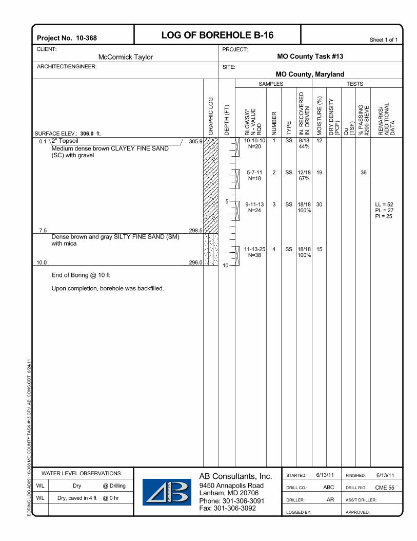
2" TopsoilMedium dense brown CLAYEY FINE SAND(SC) with gravel
Dense brown and gray SILTY FINE SAND (SM)with mica
End of Boring @ 10 ft
Upon completion, borehole was backfilled.
12
19
30
15
0.1
7.5
10.0
8/1844%
12/1867%
18/18100%
18/18100%
SS
SS
SS
SS
1
2
3
4
LL = 52PL = 27PI = 25
36
305.9
298.5
296.0
10-10-10N=20
5-7-11N=18
9-11-13N=24
11-13-25N=38
6/13/11
CME 55
SURFACE ELEV.: 306.0 ft.
WATER LEVEL OBSERVATIONS
WL
WL
6/13/11
ABC
AR
AB Consultants, Inc.9450 Annapolis RoadLanham, MD 20706
Qu
(TS
F)%
PA
SS
ING
#200
SIE
VE
FINISHED:
DRILL RIG:
ASS'T DRILLER:
APPROVED:
SAMPLES
BLO
WS
/6"
N -
VA
LUE
RQ
D
TESTS
DR
Y D
EN
SIT
Y(P
CF)
NU
MB
ER
TYP
E
MO
ISTU
RE
(%)
Phone: 301-306-3091
McCormick Taylor
Project No. 10-368CLIENT:
ARCHITECT/ENGINEER:
Sheet 1 of 1
Dry
Dry, caved in 4 ft
STARTED:
DRILL CO.:
DRILLER:
LOGGED BY:Fax: 301-306-3092
LOG OF BOREHOLE B-16
RE
MA
RK
S/
AD
DIT
ION
AL
DA
TA
@ Drilling
@ 0 hr
IN. R
EC
OV
ER
ED
IN. D
RIV
EN
PROJECT:MO County Task #13
MO County, MarylandSITE:
DE
PTH
(FT)
GR
AP
HIC
LO
G
5
10
BO
RIN
G L
OG
AB
09 1
0-36
8 M
O C
OU
NTY
TA
SK
#13
.GP
J A
B_C
ON
S.G
DT
6/2
4/11
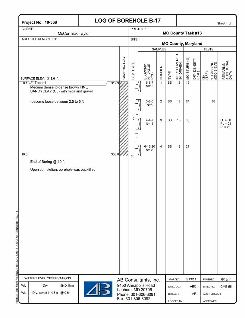
2" TopsoilMedium dense to dense brown FINESANDYCLAY (CL) with mica and gravel
-become loose between 2.5 to 5 ft
End of Boring @ 10 ft
Upon completion, borehole was backfilled.
16
24
30
21
0.1
10.0
18
18
18
18
SS
SS
SS
SS
1
2
3
4
LL = 50PL = 25PI = 25
68
312.9
303.0
6-8-7N=15
3-3-5N=8
4-4-7N=11
6-16-20N=36
6/13/11
CME 55
SURFACE ELEV.: 313.0 ft.
WATER LEVEL OBSERVATIONS
WL
WL
6/13/11
ABC
AR
AB Consultants, Inc.9450 Annapolis RoadLanham, MD 20706
Qu
(TS
F)%
PA
SS
ING
#200
SIE
VE
FINISHED:
DRILL RIG:
ASS'T DRILLER:
APPROVED:
SAMPLES
BLO
WS
/6"
N -
VA
LUE
RQ
D
TESTS
DR
Y D
EN
SIT
Y(P
CF)
NU
MB
ER
TYP
E
MO
ISTU
RE
(%)
Phone: 301-306-3091
McCormick Taylor
Project No. 10-368CLIENT:
ARCHITECT/ENGINEER:
Sheet 1 of 1
Dry
Dry, caved in 4.5 ft
STARTED:
DRILL CO.:
DRILLER:
LOGGED BY:Fax: 301-306-3092
LOG OF BOREHOLE B-17
RE
MA
RK
S/
AD
DIT
ION
AL
DA
TA
@ Drilling
@ 0 hr
IN. R
EC
OV
ER
ED
IN. D
RIV
EN
PROJECT:MO County Task #13
MO County, MarylandSITE:
DE
PTH
(FT)
GR
AP
HIC
LO
G
5
10
BO
RIN
G L
OG
AB
09 1
0-36
8 M
O C
OU
NTY
TA
SK
#13
.GP
J A
B_C
ON
S.G
DT
6/2
4/11

2" TopsoilMedium dense brown FINE SANDY SILT (ML)with mica and gravel
End of Boring @ 10 ft
Upon completion, borehole was backfilled.
15
19
19
21
0.1
10.0
18/18100%
6/1833%
18/18100%
18/18100%
SS
SS
SS
SS
1
2
3
4
55
324.9
315.0
6-6-6N=12
3-5-5N=10
6-6-5N=11
4-6-7N=13
6/14/11
CME 55
SURFACE ELEV.: 325.0 ft.
WATER LEVEL OBSERVATIONS
WL
WL
6/14/11
ABC
AR
AB Consultants, Inc.9450 Annapolis RoadLanham, MD 20706
Qu
(TS
F)%
PA
SS
ING
#200
SIE
VE
FINISHED:
DRILL RIG:
ASS'T DRILLER:
APPROVED:
SAMPLES
BLO
WS
/6"
N -
VA
LUE
RQ
D
TESTS
DR
Y D
EN
SIT
Y(P
CF)
NU
MB
ER
TYP
E
MO
ISTU
RE
(%)
Phone: 301-306-3091
McCormick Taylor
Project No. 10-368CLIENT:
ARCHITECT/ENGINEER:
Sheet 1 of 1
Dry
Dry, caved in 5 ft
STARTED:
DRILL CO.:
DRILLER:
LOGGED BY:Fax: 301-306-3092
LOG OF BOREHOLE B-18
RE
MA
RK
S/
AD
DIT
ION
AL
DA
TA
@ Drilling
@ 0 hr
IN. R
EC
OV
ER
ED
IN. D
RIV
EN
PROJECT:MO County Task #13
MO County, MarylandSITE:
DE
PTH
(FT)
GR
AP
HIC
LO
G
5
10
BO
RIN
G L
OG
AB
09 1
0-36
8 M
O C
OU
NTY
TA
SK
#13
.GP
J A
B_C
ON
S.G
DT
6/2
4/11

2" TopsoilLoose to medium dense brown SILTY FINESAND (SM)
Dense brown SILTY FINE SAND (SM) with rockfragments
End of Boring @ 10 ft
Upon completion, borehole was backfilled.
13
11
11
12
0.1
7.5
10.0
18/18100%
18/18100%
18/18100%
18/18100%
SS
SS
SS
SS
1
2
3
4
23
319.9
312.5
310.0
3-3-3N=6
5-6-7N=13
6-9-7N=16
6-16-21N=37
6/14/11
CME 55
SURFACE ELEV.: 320.0 ft.
WATER LEVEL OBSERVATIONS
WL
WL
6/14/11
ABC
AR
AB Consultants, Inc.9450 Annapolis RoadLanham, MD 20706
Qu
(TS
F)%
PA
SS
ING
#200
SIE
VE
FINISHED:
DRILL RIG:
ASS'T DRILLER:
APPROVED:
SAMPLES
BLO
WS
/6"
N -
VA
LUE
RQ
D
TESTS
DR
Y D
EN
SIT
Y(P
CF)
NU
MB
ER
TYP
E
MO
ISTU
RE
(%)
Phone: 301-306-3091
McCormick Taylor
Project No. 10-368CLIENT:
ARCHITECT/ENGINEER:
Sheet 1 of 1
Dry
Dry, caved in 4 ft
STARTED:
DRILL CO.:
DRILLER:
LOGGED BY:Fax: 301-306-3092
LOG OF BOREHOLE B-19
RE
MA
RK
S/
AD
DIT
ION
AL
DA
TA
@ Drilling
@ 0 hr
IN. R
EC
OV
ER
ED
IN. D
RIV
EN
PROJECT:MO County Task #13
MO County, MarylandSITE:
DE
PTH
(FT)
GR
AP
HIC
LO
G
5
10
BO
RIN
G L
OG
AB
09 1
0-36
8 M
O C
OU
NTY
TA
SK
#13
.GP
J A
B_C
ON
S.G
DT
6/2
4/11
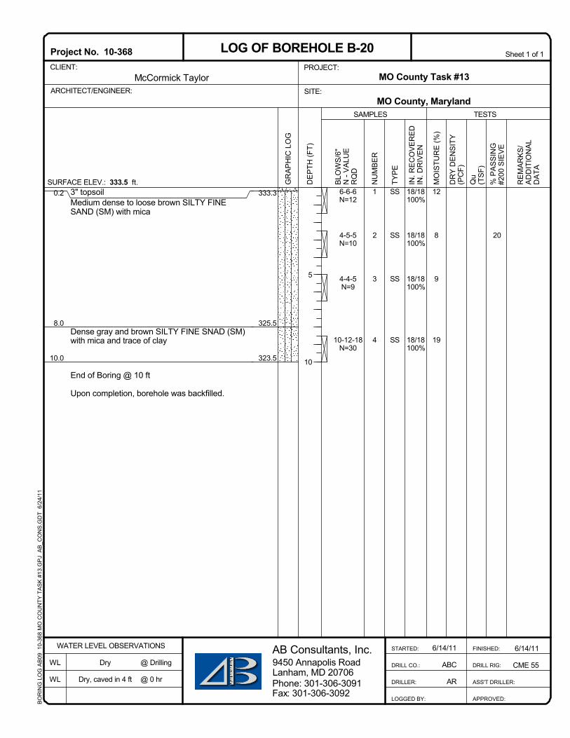
3" topsoilMedium dense to loose brown SILTY FINESAND (SM) with mica
Dense gray and brown SILTY FINE SNAD (SM)with mica and trace of clay
End of Boring @ 10 ft
Upon completion, borehole was backfilled.
12
8
9
19
0.2
8.0
10.0
18/18100%
18/18100%
18/18100%
18/18100%
SS
SS
SS
SS
1
2
3
4
20
333.3
325.5
323.5
6-6-6N=12
4-5-5N=10
4-4-5N=9
10-12-18N=30
6/14/11
CME 55
SURFACE ELEV.: 333.5 ft.
WATER LEVEL OBSERVATIONS
WL
WL
6/14/11
ABC
AR
AB Consultants, Inc.9450 Annapolis RoadLanham, MD 20706
Qu
(TS
F)%
PA
SS
ING
#200
SIE
VE
FINISHED:
DRILL RIG:
ASS'T DRILLER:
APPROVED:
SAMPLES
BLO
WS
/6"
N -
VA
LUE
RQ
D
TESTS
DR
Y D
EN
SIT
Y(P
CF)
NU
MB
ER
TYP
E
MO
ISTU
RE
(%)
Phone: 301-306-3091
McCormick Taylor
Project No. 10-368CLIENT:
ARCHITECT/ENGINEER:
Sheet 1 of 1
Dry
Dry, caved in 4 ft
STARTED:
DRILL CO.:
DRILLER:
LOGGED BY:Fax: 301-306-3092
LOG OF BOREHOLE B-20
RE
MA
RK
S/
AD
DIT
ION
AL
DA
TA
@ Drilling
@ 0 hr
IN. R
EC
OV
ER
ED
IN. D
RIV
EN
PROJECT:MO County Task #13
MO County, MarylandSITE:
DE
PTH
(FT)
GR
AP
HIC
LO
G
5
10
BO
RIN
G L
OG
AB
09 1
0-36
8 M
O C
OU
NTY
TA
SK
#13
.GP
J A
B_C
ON
S.G
DT
6/2
4/11

2" TopsoilLoose to medium dense brown SILTY FINESAND (SM) with mica
End of Boring @ 10 ft
Upon completion, borehole was backfilled.
11
13
12
11
0.1
10.0
18/18100%
18/18100%
14/1878%
18/18100%
SS
SS
SS
SS
1
2
3
4
26
332.9
323.0
4-4-5N=9
2-3-3N=6
2-2-2N=4
4-5-6N=11
6/14/11
CME 55
SURFACE ELEV.: 333.0 ft.
WATER LEVEL OBSERVATIONS
WL
WL
6/14/11
ABC
AR
AB Consultants, Inc.9450 Annapolis RoadLanham, MD 20706
Qu
(TS
F)%
PA
SS
ING
#200
SIE
VE
FINISHED:
DRILL RIG:
ASS'T DRILLER:
APPROVED:
SAMPLES
BLO
WS
/6"
N -
VA
LUE
RQ
D
TESTS
DR
Y D
EN
SIT
Y(P
CF)
NU
MB
ER
TYP
E
MO
ISTU
RE
(%)
Phone: 301-306-3091
McCormick Taylor
Project No. 10-368CLIENT:
ARCHITECT/ENGINEER:
Sheet 1 of 1
Dry
Dry, caved in 5 ft
STARTED:
DRILL CO.:
DRILLER:
LOGGED BY:Fax: 301-306-3092
LOG OF BOREHOLE B-21
RE
MA
RK
S/
AD
DIT
ION
AL
DA
TA
@ Drilling
@ 0 hr
IN. R
EC
OV
ER
ED
IN. D
RIV
EN
PROJECT:MO County Task #13
MO County, MarylandSITE:
DE
PTH
(FT)
GR
AP
HIC
LO
G
5
10
BO
RIN
G L
OG
AB
09 1
0-36
8 M
O C
OU
NTY
TA
SK
#13
.GP
J A
B_C
ON
S.G
DT
6/2
4/11

2" TopsoilMedium dense brown FINE SANDY SILTY (ML)with mica
End of Boring @ 10 ft
Upon completion, borehole was backfilled.
14
23
17
11
0.1
10.0
14/1878%
18/18100%
18/18100%
18/18100%
SS
SS
SS
SS
1
2
3
4
63
329.9
320.0
6-7-8N=15
6-8-11N=19
6-8-8N=16
8-14-16N=30
6/14/11
CME 55
SURFACE ELEV.: 330.0 ft.
WATER LEVEL OBSERVATIONS
WL
WL
6/14/11
ABC
AR
AB Consultants, Inc.9450 Annapolis RoadLanham, MD 20706
Qu
(TS
F)%
PA
SS
ING
#200
SIE
VE
FINISHED:
DRILL RIG:
ASS'T DRILLER:
APPROVED:
SAMPLES
BLO
WS
/6"
N -
VA
LUE
RQ
D
TESTS
DR
Y D
EN
SIT
Y(P
CF)
NU
MB
ER
TYP
E
MO
ISTU
RE
(%)
Phone: 301-306-3091
McCormick Taylor
Project No. 10-368CLIENT:
ARCHITECT/ENGINEER:
Sheet 1 of 1
Dry
Dry, caved in 4.5 ft
STARTED:
DRILL CO.:
DRILLER:
LOGGED BY:Fax: 301-306-3092
LOG OF BOREHOLE B-22
RE
MA
RK
S/
AD
DIT
ION
AL
DA
TA
@ Drilling
@ 0 hr
IN. R
EC
OV
ER
ED
IN. D
RIV
EN
PROJECT:MO County Task #13
MO County, MarylandSITE:
DE
PTH
(FT)
GR
AP
HIC
LO
G
5
10
BO
RIN
G L
OG
AB
09 1
0-36
8 M
O C
OU
NTY
TA
SK
#13
.GP
J A
B_C
ON
S.G
DT
6/2
4/11

3" TopsoilMedium dense brown SILTY FINE SAND (SM)with mica
Very dense brown SILTY FINE SAND (SM) withmica and disintegrated rock
End of Boring @ 10 ft
Upon completion, borehole was backfilled.
7
12
11
28
0.2
7.5
10.0
18/18100%
18/18100%
18/18100%
18/18100%
SS
SS
SS
SS
1
2
3
4
22
318.3
311.0
308.5
6-7-8N=15
7-9-11N=20
6-7-8N=15
26-27-50N=77
6/14/11
CME 55
SURFACE ELEV.: 318.5 ft.
WATER LEVEL OBSERVATIONS
WL
WL
6/14/11
ABC
AR
AB Consultants, Inc.9450 Annapolis RoadLanham, MD 20706
Qu
(TS
F)%
PA
SS
ING
#200
SIE
VE
FINISHED:
DRILL RIG:
ASS'T DRILLER:
APPROVED:
SAMPLES
BLO
WS
/6"
N -
VA
LUE
RQ
D
TESTS
DR
Y D
EN
SIT
Y(P
CF)
NU
MB
ER
TYP
E
MO
ISTU
RE
(%)
Phone: 301-306-3091
McCormick Taylor
Project No. 10-368CLIENT:
ARCHITECT/ENGINEER:
Sheet 1 of 1
Dry
Dry, caved in 4 ft
STARTED:
DRILL CO.:
DRILLER:
LOGGED BY:Fax: 301-306-3092
LOG OF BOREHOLE B-23
RE
MA
RK
S/
AD
DIT
ION
AL
DA
TA
@ Drilling
@ 0 hr
IN. R
EC
OV
ER
ED
IN. D
RIV
EN
PROJECT:MO County Task #13
MO County, MarylandSITE:
DE
PTH
(FT)
GR
AP
HIC
LO
G
5
10
BO
RIN
G L
OG
AB
09 1
0-36
8 M
O C
OU
NTY
TA
SK
#13
.GP
J A
B_C
ON
S.G
DT
6/2
4/11

3" TopsoilMedium dense brown SILTY FINE SAND (SM)with mica
-become dense between 2.5 to 4 ft
End of Boring @ 10 ft
Upon completion, borehole was backfilled.
12
11
21
19
0.2
10.0
12/1867%
18/18100%
18/18100%
18/18100%
SS
SS
SS
SS
1
2
3
4
44
314.3
304.5
6-8-9N=17
16-17-18N=35
5-6-9N=15
10-11-18N=29
6/15/11
CME 55
SURFACE ELEV.: 314.5 ft.
WATER LEVEL OBSERVATIONS
WL
WL
6/15/11
ABC
AR
AB Consultants, Inc.9450 Annapolis RoadLanham, MD 20706
Qu
(TS
F)%
PA
SS
ING
#200
SIE
VE
FINISHED:
DRILL RIG:
ASS'T DRILLER:
APPROVED:
SAMPLES
BLO
WS
/6"
N -
VA
LUE
RQ
D
TESTS
DR
Y D
EN
SIT
Y(P
CF)
NU
MB
ER
TYP
E
MO
ISTU
RE
(%)
Phone: 301-306-3091
McCormick Taylor
Project No. 10-368CLIENT:
ARCHITECT/ENGINEER:
Sheet 1 of 1
Dry
Dry, caved in 3 ft
STARTED:
DRILL CO.:
DRILLER:
LOGGED BY:Fax: 301-306-3092
LOG OF BOREHOLE B-24
RE
MA
RK
S/
AD
DIT
ION
AL
DA
TA
@ Drilling
@ 0 hr
IN. R
EC
OV
ER
ED
IN. D
RIV
EN
PROJECT:MO County Task #13
MO County, MarylandSITE:
DE
PTH
(FT)
GR
AP
HIC
LO
G
5
10
BO
RIN
G L
OG
AB
09 1
0-36
8 M
O C
OU
NTY
TA
SK
#13
.GP
J A
B_C
ON
S.G
DT
6/2
4/11

3" TopsoilMedium dense to loose brown SILTY FINESAND (SM) with mica
-become dense below 8.5 ft
End of Boring @ 10 ft
Upon completion, borehole was backfilled.
10
17
17
6
0.2
10.0
16/1889%
18/18100%
18/18100%
18/18100%
SS
SS
SS
SS
1
2
3
4
43
320.8
311.0
5-6-7N=13
6-6-9N=15
3-4-4N=8
16-18-20N=38
6/15/11
CME 55
SURFACE ELEV.: 321.0 ft.
WATER LEVEL OBSERVATIONS
WL
WL
6/15/11
ABC
AR
AB Consultants, Inc.9450 Annapolis RoadLanham, MD 20706
Qu
(TS
F)%
PA
SS
ING
#200
SIE
VE
FINISHED:
DRILL RIG:
ASS'T DRILLER:
APPROVED:
SAMPLES
BLO
WS
/6"
N -
VA
LUE
RQ
D
TESTS
DR
Y D
EN
SIT
Y(P
CF)
NU
MB
ER
TYP
E
MO
ISTU
RE
(%)
Phone: 301-306-3091
McCormick Taylor
Project No. 10-368CLIENT:
ARCHITECT/ENGINEER:
Sheet 1 of 1
Dry
Dry, caved in 4 ft
STARTED:
DRILL CO.:
DRILLER:
LOGGED BY:Fax: 301-306-3092
LOG OF BOREHOLE B-25
RE
MA
RK
S/
AD
DIT
ION
AL
DA
TA
@ Drilling
@ 0 hr
IN. R
EC
OV
ER
ED
IN. D
RIV
EN
PROJECT:MO County Task #13
MO County, MarylandSITE:
DE
PTH
(FT)
GR
AP
HIC
LO
G
5
10
BO
RIN
G L
OG
AB
09 1
0-36
8 M
O C
OU
NTY
TA
SK
#13
.GP
J A
B_C
ON
S.G
DT
6/2
4/11

3" TopsoilMedium dense brown SILTY FINE SAND (SM)with mica
End of Boring @ 10 ft
Upon completion, borehole was backfilled.
14
10
13
15
0.2
10.0
18/18100%
18/18100%
18/18100%
18/18100%
SS
SS
SS
SS
1
2
3
4
24
318.8
309.0
4-6-9N=15
6-9-11N=20
6-10-11N=21
8-12-15N=27
6/15/11
CME 55
SURFACE ELEV.: 319.0 ft.
WATER LEVEL OBSERVATIONS
WL
WL
6/15/11
ABC
AR
AB Consultants, Inc.9450 Annapolis RoadLanham, MD 20706
Qu
(TS
F)%
PA
SS
ING
#200
SIE
VE
FINISHED:
DRILL RIG:
ASS'T DRILLER:
APPROVED:
SAMPLES
BLO
WS
/6"
N -
VA
LUE
RQ
D
TESTS
DR
Y D
EN
SIT
Y(P
CF)
NU
MB
ER
TYP
E
MO
ISTU
RE
(%)
Phone: 301-306-3091
McCormick Taylor
Project No. 10-368CLIENT:
ARCHITECT/ENGINEER:
Sheet 1 of 1
Dry
Dry, caved in 4 ft
STARTED:
DRILL CO.:
DRILLER:
LOGGED BY:Fax: 301-306-3092
LOG OF BOREHOLE B-26
RE
MA
RK
S/
AD
DIT
ION
AL
DA
TA
@ Drilling
@ 0 hr
IN. R
EC
OV
ER
ED
IN. D
RIV
EN
PROJECT:MO County Task #13
MO County, MarylandSITE:
DE
PTH
(FT)
GR
AP
HIC
LO
G
5
10
BO
RIN
G L
OG
AB
09 1
0-36
8 M
O C
OU
NTY
TA
SK
#13
.GP
J A
B_C
ON
S.G
DT
6/2
4/11

2" TopsoilMedium dense brown SILTY FINE SAND (SM)with mica
-become loose between 5 to 6.5 ft
End of Boring @ 10 ft
Upon completion, borehole was backfilled.
26
8
13
11
0.1
10.0
18/18100%
18/18100%
18/18100%
18/18100%
SS
SS
SS
SS
1
2
3
4
19
333.9
324.0
4-6-6N=12
3-5-6N=11
2-2-3N=5
5-6-6N=12
6/15/11
CME 55
SURFACE ELEV.: 334.0 ft.
WATER LEVEL OBSERVATIONS
WL
WL
6/15/11
ABC
AR
AB Consultants, Inc.9450 Annapolis RoadLanham, MD 20706
Qu
(TS
F)%
PA
SS
ING
#200
SIE
VE
FINISHED:
DRILL RIG:
ASS'T DRILLER:
APPROVED:
SAMPLES
BLO
WS
/6"
N -
VA
LUE
RQ
D
TESTS
DR
Y D
EN
SIT
Y(P
CF)
NU
MB
ER
TYP
E
MO
ISTU
RE
(%)
Phone: 301-306-3091
McCormick Taylor
Project No. 10-368CLIENT:
ARCHITECT/ENGINEER:
Sheet 1 of 1
Dry
Dry, caved in 4 ft
STARTED:
DRILL CO.:
DRILLER:
LOGGED BY:Fax: 301-306-3092
LOG OF BOREHOLE B-27
RE
MA
RK
S/
AD
DIT
ION
AL
DA
TA
@ Drilling
@ 0 hr
IN. R
EC
OV
ER
ED
IN. D
RIV
EN
PROJECT:MO County Task #13
MO County, MarylandSITE:
DE
PTH
(FT)
GR
AP
HIC
LO
G
5
10
BO
RIN
G L
OG
AB
09 1
0-36
8 M
O C
OU
NTY
TA
SK
#13
.GP
J A
B_C
ON
S.G
DT
6/2
4/11

1" TopsoilMedium dense brown SILTY FINE SAND (SM)with mica
End of Boring @ 10 ft
Upon completion, borehole was backfilled.
7
13
14
11
0.1
10.0
18/18100%
18/18100%
14/1878%
18/18100%
SS
SS
SS
SS
1
2
3
4
25
338.4
328.5
6-6-6N=12
5-5-5N=10
2-9-17N=26
5-5-7N=12
6/15/11
CME 55
SURFACE ELEV.: 338.5 ft.
WATER LEVEL OBSERVATIONS
WL
WL
6/15/11
ABC
AR
AB Consultants, Inc.9450 Annapolis RoadLanham, MD 20706
Qu
(TS
F)%
PA
SS
ING
#200
SIE
VE
FINISHED:
DRILL RIG:
ASS'T DRILLER:
APPROVED:
SAMPLES
BLO
WS
/6"
N -
VA
LUE
RQ
D
TESTS
DR
Y D
EN
SIT
Y(P
CF)
NU
MB
ER
TYP
E
MO
ISTU
RE
(%)
Phone: 301-306-3091
McCormick Taylor
Project No. 10-368CLIENT:
ARCHITECT/ENGINEER:
Sheet 1 of 1
Dry
Dry, caved in 4 ft
STARTED:
DRILL CO.:
DRILLER:
LOGGED BY:Fax: 301-306-3092
LOG OF BOREHOLE B-28
RE
MA
RK
S/
AD
DIT
ION
AL
DA
TA
@ Drilling
@ 0 hr
IN. R
EC
OV
ER
ED
IN. D
RIV
EN
PROJECT:MO County Task #13
MO County, MarylandSITE:
DE
PTH
(FT)
GR
AP
HIC
LO
G
5
10
BO
RIN
G L
OG
AB
09 1
0-36
8 M
O C
OU
NTY
TA
SK
#13
.GP
J A
B_C
ON
S.G
DT
6/2
4/11

0
10
20
30
40
50
60
70
80
90
100
0.0010.010.11101000
10
20
30
40
50
60
70
80
90
100DEPTH
Cobbles Gravel
Particle size (mm)
Percent
Passing
Sand Silt Claycoarse fine coarse medium fine
B-01 2.5BOREHOLE NO.
GRAIN SIZE DISTRIBUTION9450 Annapolis RoadLanham, Maryland 20706Phone: 301-306-3091Fax: 301-306-3092
AB Consultants, Inc.CLIENT: McCormick TaylorPROJECT NO.: 10-368PROJECT: MO County Task #13SITE:
MO County, Maryland
US
_GS
D_D
OU
BLE
10-
368
MO
CO
UN
TY T
AS
K #
13.G
PJ
AB
_CO
NS
.GD
T 6
/24/
11
0
10
20
30
40
50
60
70
80
90
100
0.0010.010.11101000
10
20
30
40
50
60
70
80
90
100DEPTH
Cobbles Gravel
Particle size (mm)
Percent
Passing
Sand Silt Claycoarse fine coarse medium fine
B-02 2.5BOREHOLE NO.

0
10
20
30
40
50
60
70
80
90
100
0.0010.010.11101000
10
20
30
40
50
60
70
80
90
100DEPTH
Cobbles Gravel
Particle size (mm)
Percent
Passing
Sand Silt Claycoarse fine coarse medium fine
B-03 2.5BOREHOLE NO.
GRAIN SIZE DISTRIBUTION9450 Annapolis RoadLanham, Maryland 20706Phone: 301-306-3091Fax: 301-306-3092
AB Consultants, Inc.CLIENT: McCormick TaylorPROJECT NO.: 10-368PROJECT: MO County Task #13SITE:
MO County, Maryland
US
_GS
D_D
OU
BLE
10-
368
MO
CO
UN
TY T
AS
K #
13.G
PJ
AB
_CO
NS
.GD
T 6
/24/
11
0
10
20
30
40
50
60
70
80
90
100
0.0010.010.11101000
10
20
30
40
50
60
70
80
90
100DEPTH
Cobbles Gravel
Particle size (mm)
Percent
Passing
Sand Silt Claycoarse fine coarse medium fine
B-04 5.0BOREHOLE NO.

0
10
20
30
40
50
60
70
80
90
100
0.0010.010.11101000
10
20
30
40
50
60
70
80
90
100DEPTH
Cobbles Gravel
Particle size (mm)
Percent
Passing
Sand Silt Claycoarse fine coarse medium fine
B-05 2.5BOREHOLE NO.
GRAIN SIZE DISTRIBUTION9450 Annapolis RoadLanham, Maryland 20706Phone: 301-306-3091Fax: 301-306-3092
AB Consultants, Inc.CLIENT: McCormick TaylorPROJECT NO.: 10-368PROJECT: MO County Task #13SITE:
MO County, Maryland
US
_GS
D_D
OU
BLE
10-
368
MO
CO
UN
TY T
AS
K #
13.G
PJ
AB
_CO
NS
.GD
T 6
/24/
11
0
10
20
30
40
50
60
70
80
90
100
0.0010.010.11101000
10
20
30
40
50
60
70
80
90
100DEPTH
Cobbles Gravel
Particle size (mm)
Percent
Passing
Sand Silt Claycoarse fine coarse medium fine
B-06 5.0BOREHOLE NO.
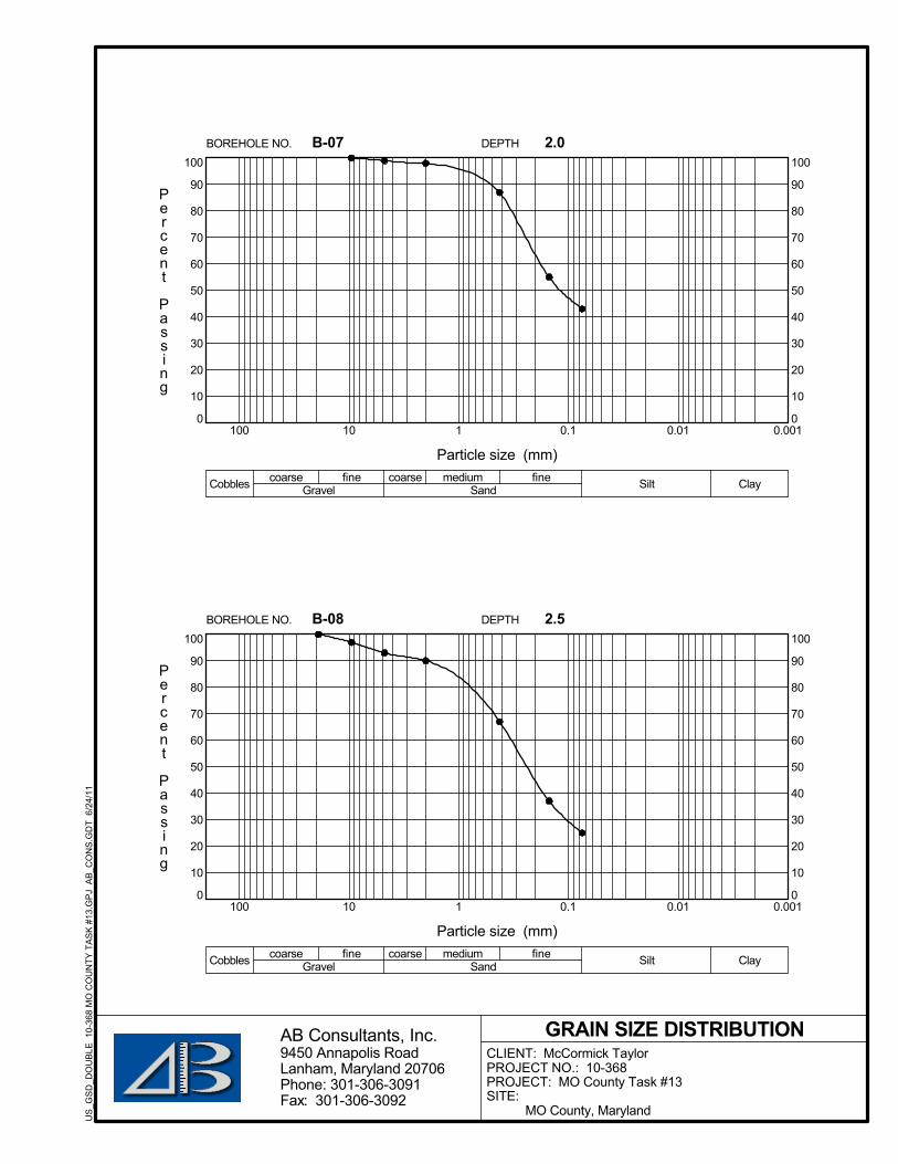
0
10
20
30
40
50
60
70
80
90
100
0.0010.010.11101000
10
20
30
40
50
60
70
80
90
100DEPTH
Cobbles Gravel
Particle size (mm)
Percent
Passing
Sand Silt Claycoarse fine coarse medium fine
B-07 2.0BOREHOLE NO.
GRAIN SIZE DISTRIBUTION9450 Annapolis RoadLanham, Maryland 20706Phone: 301-306-3091Fax: 301-306-3092
AB Consultants, Inc.CLIENT: McCormick TaylorPROJECT NO.: 10-368PROJECT: MO County Task #13SITE:
MO County, Maryland
US
_GS
D_D
OU
BLE
10-
368
MO
CO
UN
TY T
AS
K #
13.G
PJ
AB
_CO
NS
.GD
T 6
/24/
11
0
10
20
30
40
50
60
70
80
90
100
0.0010.010.11101000
10
20
30
40
50
60
70
80
90
100DEPTH
Cobbles Gravel
Particle size (mm)
Percent
Passing
Sand Silt Claycoarse fine coarse medium fine
B-08 2.5BOREHOLE NO.

0
10
20
30
40
50
60
70
80
90
100
0.0010.010.11101000
10
20
30
40
50
60
70
80
90
100DEPTH
Cobbles Gravel
Particle size (mm)
Percent
Passing
Sand Silt Claycoarse fine coarse medium fine
B-10 2.5BOREHOLE NO.
GRAIN SIZE DISTRIBUTION9450 Annapolis RoadLanham, Maryland 20706Phone: 301-306-3091Fax: 301-306-3092
AB Consultants, Inc.CLIENT: McCormick TaylorPROJECT NO.: 10-368PROJECT: MO County Task #13SITE:
MO County, Maryland
US
_GS
D_D
OU
BLE
10-
368
MO
CO
UN
TY T
AS
K #
13.G
PJ
AB
_CO
NS
.GD
T 6
/24/
11
0
10
20
30
40
50
60
70
80
90
100
0.0010.010.11101000
10
20
30
40
50
60
70
80
90
100DEPTH
Cobbles Gravel
Particle size (mm)
Percent
Passing
Sand Silt Claycoarse fine coarse medium fine
B-11 2.5BOREHOLE NO.

0
10
20
30
40
50
60
70
80
90
100
0.0010.010.11101000
10
20
30
40
50
60
70
80
90
100DEPTH
Cobbles Gravel
Particle size (mm)
Percent
Passing
Sand Silt Claycoarse fine coarse medium fine
B-14 2.5BOREHOLE NO.
GRAIN SIZE DISTRIBUTION9450 Annapolis RoadLanham, Maryland 20706Phone: 301-306-3091Fax: 301-306-3092
AB Consultants, Inc.CLIENT: McCormick TaylorPROJECT NO.: 10-368PROJECT: MO County Task #13SITE:
MO County, Maryland
US
_GS
D_D
OU
BLE
10-
368
MO
CO
UN
TY T
AS
K #
13.G
PJ
AB
_CO
NS
.GD
T 6
/24/
11
0
10
20
30
40
50
60
70
80
90
100
0.0010.010.11101000
10
20
30
40
50
60
70
80
90
100DEPTH
Cobbles Gravel
Particle size (mm)
Percent
Passing
Sand Silt Claycoarse fine coarse medium fine
B-15 2.5BOREHOLE NO.

0
10
20
30
40
50
60
70
80
90
100
0.0010.010.11101000
10
20
30
40
50
60
70
80
90
100DEPTH
Cobbles Gravel
Particle size (mm)
Percent
Passing
Sand Silt Claycoarse fine coarse medium fine
B-16 2.5BOREHOLE NO.
GRAIN SIZE DISTRIBUTION9450 Annapolis RoadLanham, Maryland 20706Phone: 301-306-3091Fax: 301-306-3092
AB Consultants, Inc.CLIENT: McCormick TaylorPROJECT NO.: 10-368PROJECT: MO County Task #13SITE:
MO County, Maryland
US
_GS
D_D
OU
BLE
10-
368
MO
CO
UN
TY T
AS
K #
13.G
PJ
AB
_CO
NS
.GD
T 6
/24/
11
0
10
20
30
40
50
60
70
80
90
100
0.0010.010.11101000
10
20
30
40
50
60
70
80
90
100DEPTH
Cobbles Gravel
Particle size (mm)
Percent
Passing
Sand Silt Claycoarse fine coarse medium fine
B-17 2.5BOREHOLE NO.

0
10
20
30
40
50
60
70
80
90
100
0.0010.010.11101000
10
20
30
40
50
60
70
80
90
100DEPTH
Cobbles Gravel
Particle size (mm)
Percent
Passing
Sand Silt Claycoarse fine coarse medium fine
B-18 2.5BOREHOLE NO.
GRAIN SIZE DISTRIBUTION9450 Annapolis RoadLanham, Maryland 20706Phone: 301-306-3091Fax: 301-306-3092
AB Consultants, Inc.CLIENT: McCormick TaylorPROJECT NO.: 10-368PROJECT: MO County Task #13SITE:
MO County, Maryland
US
_GS
D_D
OU
BLE
10-
368
MO
CO
UN
TY T
AS
K #
13.G
PJ
AB
_CO
NS
.GD
T 6
/24/
11
0
10
20
30
40
50
60
70
80
90
100
0.0010.010.11101000
10
20
30
40
50
60
70
80
90
100DEPTH
Cobbles Gravel
Particle size (mm)
Percent
Passing
Sand Silt Claycoarse fine coarse medium fine
B-19 2.5BOREHOLE NO.

0
10
20
30
40
50
60
70
80
90
100
0.0010.010.11101000
10
20
30
40
50
60
70
80
90
100DEPTH
Cobbles Gravel
Particle size (mm)
Percent
Passing
Sand Silt Claycoarse fine coarse medium fine
B-20 2.5BOREHOLE NO.
GRAIN SIZE DISTRIBUTION9450 Annapolis RoadLanham, Maryland 20706Phone: 301-306-3091Fax: 301-306-3092
AB Consultants, Inc.CLIENT: McCormick TaylorPROJECT NO.: 10-368PROJECT: MO County Task #13SITE:
MO County, Maryland
US
_GS
D_D
OU
BLE
10-
368
MO
CO
UN
TY T
AS
K #
13.G
PJ
AB
_CO
NS
.GD
T 6
/24/
11
0
10
20
30
40
50
60
70
80
90
100
0.0010.010.11101000
10
20
30
40
50
60
70
80
90
100DEPTH
Cobbles Gravel
Particle size (mm)
Percent
Passing
Sand Silt Claycoarse fine coarse medium fine
B-21 5.0BOREHOLE NO.

0
10
20
30
40
50
60
70
80
90
100
0.0010.010.11101000
10
20
30
40
50
60
70
80
90
100DEPTH
Cobbles Gravel
Particle size (mm)
Percent
Passing
Sand Silt Claycoarse fine coarse medium fine
B-22 2.5BOREHOLE NO.
GRAIN SIZE DISTRIBUTION9450 Annapolis RoadLanham, Maryland 20706Phone: 301-306-3091Fax: 301-306-3092
AB Consultants, Inc.CLIENT: McCormick TaylorPROJECT NO.: 10-368PROJECT: MO County Task #13SITE:
MO County, Maryland
US
_GS
D_D
OU
BLE
10-
368
MO
CO
UN
TY T
AS
K #
13.G
PJ
AB
_CO
NS
.GD
T 6
/24/
11
0
10
20
30
40
50
60
70
80
90
100
0.0010.010.11101000
10
20
30
40
50
60
70
80
90
100DEPTH
Cobbles Gravel
Particle size (mm)
Percent
Passing
Sand Silt Claycoarse fine coarse medium fine
B-23 2.5BOREHOLE NO.

0
10
20
30
40
50
60
70
80
90
100
0.0010.010.11101000
10
20
30
40
50
60
70
80
90
100DEPTH
Cobbles Gravel
Particle size (mm)
Percent
Passing
Sand Silt Claycoarse fine coarse medium fine
B-24 2.5BOREHOLE NO.
GRAIN SIZE DISTRIBUTION9450 Annapolis RoadLanham, Maryland 20706Phone: 301-306-3091Fax: 301-306-3092
AB Consultants, Inc.CLIENT: McCormick TaylorPROJECT NO.: 10-368PROJECT: MO County Task #13SITE:
MO County, Maryland
US
_GS
D_D
OU
BLE
10-
368
MO
CO
UN
TY T
AS
K #
13.G
PJ
AB
_CO
NS
.GD
T 6
/24/
11
0
10
20
30
40
50
60
70
80
90
100
0.0010.010.11101000
10
20
30
40
50
60
70
80
90
100DEPTH
Cobbles Gravel
Particle size (mm)
Percent
Passing
Sand Silt Claycoarse fine coarse medium fine
B-25 2.5BOREHOLE NO.

0
10
20
30
40
50
60
70
80
90
100
0.0010.010.11101000
10
20
30
40
50
60
70
80
90
100DEPTH
Cobbles Gravel
Particle size (mm)
Percent
Passing
Sand Silt Claycoarse fine coarse medium fine
B-26 2.5BOREHOLE NO.
GRAIN SIZE DISTRIBUTION9450 Annapolis RoadLanham, Maryland 20706Phone: 301-306-3091Fax: 301-306-3092
AB Consultants, Inc.CLIENT: McCormick TaylorPROJECT NO.: 10-368PROJECT: MO County Task #13SITE:
MO County, Maryland
US
_GS
D_D
OU
BLE
10-
368
MO
CO
UN
TY T
AS
K #
13.G
PJ
AB
_CO
NS
.GD
T 6
/24/
11
0
10
20
30
40
50
60
70
80
90
100
0.0010.010.11101000
10
20
30
40
50
60
70
80
90
100DEPTH
Cobbles Gravel
Particle size (mm)
Percent
Passing
Sand Silt Claycoarse fine coarse medium fine
B-27 2.5BOREHOLE NO.

0
10
20
30
40
50
60
70
80
90
100
0.0010.010.11101000
10
20
30
40
50
60
70
80
90
100DEPTH
Cobbles Gravel
Particle size (mm)
Percent
Passing
Sand Silt Claycoarse fine coarse medium fine
B-28 2.5BOREHOLE NO.
GRAIN SIZE DISTRIBUTION9450 Annapolis RoadLanham, Maryland 20706Phone: 301-306-3091Fax: 301-306-3092
AB Consultants, Inc.CLIENT: McCormick TaylorPROJECT NO.: 10-368PROJECT: MO County Task #13SITE:
MO County, Maryland
US
_GS
D_D
OU
BLE
10-
368
MO
CO
UN
TY T
AS
K #
13.G
PJ
AB
_CO
NS
.GD
T 6
/24/
11

AB CONSULTANTS, INC.
FIELD INFILTRATION TEST RESULTS

ON-SITE INFILTRATION TESTJOB NO.: 10-368 DRILLED BY:
PROJECT: MO County Task # 13 DATE: 6/11/2011
LOCATION:
Measurements (in.)HOLE NO.: B-1 d1 4
HOLE DEPTH: 79
HOLE DIAMETER: 8
PRE-SOAK DATE: 5/31/2011
d2 47
PIPE DIAMETER: 5
PIPE MATERIAL: PVC
TESTED BY: SP
TESTED DATE: 6/1/2011 d3 70 1/2
Pre-soak water remaining in the hole: Yes / No Depth: (from bottom) 23 1/2
Time Time Escaped Water Level* (Below Reference) Drop in Level Infiltration Rate
(min) (in.) (in.) (in./hr)
9:30 36 3/16 --- ---
10:30 60 36 8/16 5/16 0.31
11:30 60 37 8/16 0.50
12:30 60 37 6/16 6/16 0.38
1:30 60 37 12/16 6/16 0.38
NOTE: * Reading accuracy to 1/16"
Average of 4-hr Monitoring Period: 0.39 in./hr
Recommended Infiltration Rate: 0.40 in./hr
Report Reviewed and Prepared By: KC
REMARKS:
AB Consultants, Inc. Rev. 12/01/07

ON-SITE INFILTRATION TESTJOB NO.: 10-368 DRILLED BY:
PROJECT: MO County Task # 13 DATE: 6/11/2011
LOCATION:
Measurements (in.)HOLE NO.: B-2 d1 7
HOLE DEPTH: 71
HOLE DIAMETER: 8
PRE-SOAK DATE: 6/11/2011
d2 72 1/2
PIPE DIAMETER: 6
PIPE MATERIAL: PVC
TESTED BY: SP/AP
TESTED DATE: 6/12/2011 d3 78
Pre-soak water remaining in the hole: Yes / No Depth: (from bottom) 5 1/2
Time Time Escaped Water Level* (Below Reference) Drop in Level Infiltration Rate
(min) (in.) (in.) (in./hr)
8:45 51 7/16 --- ---
9:45 60 52 13/16 1 6/16 1.38
10:45 60 54 3/16 1 6/16 1.38
11:45 60 55 7/16 1 4/16 1.25
12:45 60 56 11/16 1 4/16 1.25
NOTE: * Reading accuracy to 1/16"
Average of 4-hr Monitoring Period: 1.31 in./hr
Recommended Infiltration Rate: 1.30 in./hr
Report Reviewed and Prepared By: KC
REMARKS:
AB Consultants, Inc. Rev. 12/01/07

ON-SITE INFILTRATION TESTJOB NO.: 10-368 DRILLED BY:
PROJECT: MO County Task # 13 DATE: 6/11/2011
LOCATION:
Measurements (in.)HOLE NO.: B-3 d1 12
HOLE DEPTH: 66
HOLE DIAMETER: 8
PRE-SOAK DATE: 6/11/2011
d2 66 7/8
PIPE DIAMETER: 6
PIPE MATERIAL: PVC
TESTED BY: SP/AP
TESTED DATE: 6/12/2011 d3 78
Pre-soak water remaining in the hole: Yes / No Depth: (from bottom) 11 1/8
Time Time Escaped Water Level* (Below Reference) Drop in Level Infiltration Rate
(min) (in.) (in.) (in./hr)
8:30 50 4/16 --- ---
9:30 60 51 7/16 1 3/16 1.19
10:30 60 52 6/16 15/16 0.94
11:30 60 53 2/16 12/16 0.75
12:30 60 53 14/16 12/16 0.75
NOTE: * Reading accuracy to 1/16"
Average of 4-hr Monitoring Period: 0.91 in./hr
Recommended Infiltration Rate: 0.90 in./hr
Report Reviewed and Prepared By: KC
REMARKS:
AB Consultants, Inc. Rev. 12/01/07

ON-SITE INFILTRATION TESTJOB NO.: 10-368 DRILLED BY:
PROJECT: MO County Task # 13 DATE: 6/11/2011
LOCATION:
Measurements (in.)HOLE NO.: B-4 d1 9
HOLE DEPTH: 79
HOLE DIAMETER: 8
PRE-SOAK DATE: 6/11/2011
d2 58 1/2
PIPE DIAMETER: 6
PIPE MATERIAL: PVC
TESTED BY: SP/AP
TESTED DATE: 6/12/2011 d3 70
Pre-soak water remaining in the hole: Yes / No Depth: (from bottom) 11 1/2
Time Time Escaped Water Level* (Below Reference) Drop in Level Infiltration Rate
(min) (in.) (in.) (in./hr)
9:00 46 --- ---
10:00 60 46 6/16 6/16 0.38
11:00 60 46 12/16 6/16 0.38
12:00 60 47 2/16 6/16 0.38
1:00 60 47 9/16 7/16 0.44
NOTE: * Reading accuracy to 1/16"
Average of 4-hr Monitoring Period: 0.39 in./hr
Recommended Infiltration Rate: 0.40 in./hr
Report Reviewed and Prepared By: KC
REMARKS:
AB Consultants, Inc. Rev. 12/01/07

ON-SITE INFILTRATION TESTJOB NO.: 10-368 DRILLED BY:
PROJECT: MO County Task # 13 DATE: 6/11/2011
LOCATION:
Measurements (in.)HOLE NO.: B-5 d1 14
HOLE DEPTH: 59
HOLE DIAMETER: 8
PRE-SOAK DATE: 6/11/2011
d2 64 3/4
PIPE DIAMETER: 6
PIPE MATERIAL: PVC
TESTED BY: SP/AP
TESTED DATE: 6/12/2011 d3 73
Pre-soak water remaining in the hole: Yes / No Depth: (from bottom) 8 1/4
Time Time Escaped Water Level* (Below Reference) Drop in Level Infiltration Rate
(min) (in.) (in.) (in./hr)
9:00 46 15/16 --- ---
10:00 60 47 8/16 9/16 0.56
11:00 60 48 1/16 9/16 0.56
12:00 60 48 14/16 13/16 0.81
1:00 60 49 6/16 8/16 0.50
NOTE: * Reading accuracy to 1/16"
Average of 4-hr Monitoring Period: 0.61 in./hr
Recommended Infiltration Rate: 0.60 in./hr
Report Reviewed and Prepared By: KC
REMARKS:
AB Consultants, Inc. Rev. 12/01/07

ON-SITE INFILTRATION TESTJOB NO.: 10-368 DRILLED BY:
PROJECT: MO County Task # 13 DATE: 6/11/2011
LOCATION:
Measurements (in.)HOLE NO.: B-6 d1 14
HOLE DEPTH: 68
HOLE DIAMETER: 8
PRE-SOAK DATE: 6/11/2011
d2 59 7/8
PIPE DIAMETER: 6
PIPE MATERIAL: PVC
TESTED BY: SP/AP
TESTED DATE: 6/12/2011 d3 82
Pre-soak water remaining in the hole: Yes / No Depth: (from bottom) 22 1/8
Time Time Escaped Water Level* (Below Reference) Drop in Level Infiltration Rate
(min) (in.) (in.) (in./hr)
10:20 58 8/16 --- ---
11:20 60 58 10/16 2/16 0.13
12:20 60 58 12/16 2/16 0.13
13:20 60 58 13/16 1/16 0.06
14:20 60 58 14/16 1/16 0.06
NOTE: * Reading accuracy to 1/16"
Average of 4-hr Monitoring Period: 0.09 in./hr
Recommended Infiltration Rate: 0.10 in./hr
Report Reviewed and Prepared By: KC
REMARKS:
AB Consultants, Inc. Rev. 12/01/07

ON-SITE INFILTRATION TESTJOB NO.: 10-368 DRILLED BY:
PROJECT: MO County Task # 13 DATE: 6/11/2011
LOCATION:
Measurements (in.)HOLE NO.: B-7 d1 2
HOLE DEPTH: 38
HOLE DIAMETER: 8
PRE-SOAK DATE: 6/11/2011
d2 23 4/7
PIPE DIAMETER: 6
PIPE MATERIAL: PVC
TESTED BY: SP/AP
TESTED DATE: 6/12/2011 d3 40
Pre-soak water remaining in the hole: Yes / No Depth: (from bottom) 16 4/9
Time Time Escaped Water Level* (Below Reference) Drop in Level Infiltration Rate
(min) (in.) (in.) (in./hr)
10:55 15 15/16 --- ---
11:55 60 16 7/16 8/16 0.50
12:55 60 17 1/16 10/16 0.63
13:55 60 17 9/16 8/16 0.50
14:55 60 18 2/16 9/16 0.56
NOTE: * Reading accuracy to 1/16"
Average of 4-hr Monitoring Period: 0.55 in./hr
Recommended Infiltration Rate: 0.55 in./hr
Report Reviewed and Prepared By:
REMARKS:
AB Consultants, Inc. Rev. 12/01/07

ON-SITE INFILTRATION TESTJOB NO.: 10-368 DRILLED BY:
PROJECT: MO County Task # 13 DATE: 6/11/2011
LOCATION:
Measurements (in.)HOLE NO.: B-8 d1 32 1/2
HOLE DEPTH: 69.5
HOLE DIAMETER: 8
PRE-SOAK DATE: 6/11/2011
d2 95 1/4
PIPE DIAMETER: 6
PIPE MATERIAL: PVC
TESTED BY: SP/AP
TESTED DATE: 6/12/2011 d3 102
Pre-soak water remaining in the hole: Yes / No Depth: (from bottom) 6 3/4
Time Time Escaped Water Level* (Below Reference) Drop in Level Infiltration Rate
(min) (in.) (in.) (in./hr)
10:40 74 1/16 --- ---
11:40 60 75 15/16 0.94
12:40 60 75 15/16 15/16 0.94
13:40 60 77 1/16 1 2/16 1.13
14:40 60 78 7/16 1 6/16 1.38
NOTE: * Reading accuracy to 1/16"
Average of 4-hr Monitoring Period: 1.09 in./hr
Recommended Infiltration Rate: 1.00 in./hr
Report Reviewed and Prepared By: KC
REMARKS:
AB Consultants, Inc. Rev. 12/01/07

ON-SITE INFILTRATION TESTJOB NO.: 10-368 DRILLED BY:
PROJECT: MO County Task # 13 DATE: 6/11/2011
LOCATION:
Measurements (in.)HOLE NO.: B-10 d1 9
HOLE DEPTH: 53
HOLE DIAMETER: 8
PRE-SOAK DATE: 6/11/2011
d2 48 5/8
PIPE DIAMETER: 6
PIPE MATERIAL: PVC
TESTED BY: SP/AP
TESTED DATE: 6/12/2011 d3 62
Pre-soak water remaining in the hole: Yes / No Depth: (from bottom) 13 3/8
Time Time Escaped Water Level* (Below Reference) Drop in Level Infiltration Rate
(min) (in.) (in.) (in./hr)
9:45 36 12/16 --- ---
10:45 60 37 2/16 6/16 0.38
11:45 60 37 7/16 5/16 0.31
12:45 60 37 14/16 7/16 0.44
13:45 60 38 5/16 7/16 0.44
NOTE: * Reading accuracy to 1/16"
Average of 4-hr Monitoring Period: 0.39 in./hr
Recommended Infiltration Rate: 0.40 in./hr
Report Reviewed and Prepared By: KC
REMARKS:
AB Consultants, Inc. Rev. 12/01/07

ON-SITE INFILTRATION TESTJOB NO.: 10-368 DRILLED BY:
PROJECT: MO County Task # 13 DATE: 6/11/2011
LOCATION:
Measurements (in.)HOLE NO.: B-11 d1 9
HOLE DEPTH: 72
HOLE DIAMETER: 8
PRE-SOAK DATE: 6/11/2011
d2 0
PIPE DIAMETER: 6
PIPE MATERIAL: PVC
TESTED BY: SP/AP
TESTED DATE: 6/12/2011 d3 81
Pre-soak water remaining in the hole: Yes / No Depth: (from bottom) 81
Time Time Escaped Water Level* (Below Reference) Drop in Level Infiltration Rate
(min) (in.) (in.) (in./hr)
9:50 49 1/16 --- ---
10:50 60 51 15/16 2 14/16 2.88
11:50 60 54 8/16 2 9/16 2.56
12:50 60 56 11/16 2 3/16 2.19
13:50 60 58 14/16 2 3/16 2.19
NOTE: * Reading accuracy to 1/16"
Average of 4-hr Monitoring Period: 2.45 in./hr
Recommended Infiltration Rate: 2.45 in./hr
Report Reviewed and Prepared By: KC
REMARKS:
AB Consultants, Inc. Rev. 12/01/07

ON-SITE INFILTRATION TESTJOB NO.: 10-368 DRILLED BY:
PROJECT: MO County Task # 13 DATE: 6/11/2011
LOCATION:
Measurements (in.)HOLE NO.: B-14 d1 13
HOLE DEPTH: 55
HOLE DIAMETER: 8
PRE-SOAK DATE: 6/11/2011
d2 59 1/2
PIPE DIAMETER: 6
PIPE MATERIAL: PVC
TESTED BY: SP/AP
TESTED DATE: 6/12/2011 d3 68
Pre-soak water remaining in the hole: Yes / No Depth: (from bottom) 8 1/2
Time Time Escaped Water Level* (Below Reference) Drop in Level Infiltration Rate
(min) (in.) (in.) (in./hr)
10:10 43 14/16 --- ---
11:10 60 44 12/16 14/16 0.88
12:10 60 45 10/16 14/16 0.88
13:10 60 46 11/16 1 1/16 1.06
14:10 60 47 12/16 1 1/16 1.06
NOTE: * Reading accuracy to 1/16"
Average of 4-hr Monitoring Period: 0.97 in./hr
Recommended Infiltration Rate: 0.95 in./hr
Report Reviewed and Prepared By: KC
REMARKS:
AB Consultants, Inc. Rev. 12/01/07

ON-SITE INFILTRATION TESTJOB NO.: 10-368 DRILLED BY:
PROJECT: MO County Task # 13 DATE: 6/11/2011
LOCATION:
Measurements (in.)HOLE NO.: B-15 d1 20
HOLE DEPTH: 16.5
HOLE DIAMETER: 8
PRE-SOAK DATE: 6/11/2011
d2 28 1/2
PIPE DIAMETER: 6
PIPE MATERIAL: PVC
TESTED BY: SP/AP
TESTED DATE: 6/12/2011 d3 45
Pre-soak water remaining in the hole: Yes / No Depth: (from bottom) 16 1/2
Time Time Escaped Water Level* (Below Reference) Drop in Level Infiltration Rate
(min) (in.) (in.) (in./hr)
10:40 19 6/16 --- ---
11:40 60 19 8/16 2/16 0.13
12:40 60 19 10/16 2/16 0.13
13:40 60 19 11/16 1/16 0.06
14:40 60 19 12/16 1/16 0.06
NOTE: * Reading accuracy to 1/16"
Average of 4-hr Monitoring Period: 0.09 in./hr
Recommended Infiltration Rate: 0.10 in./hr
Report Reviewed and Prepared By: KC
REMARKS:
AB Consultants, Inc. Rev. 12/01/07

ON-SITE INFILTRATION TESTJOB NO.: 10-368 DRILLED BY:
PROJECT: MO County Task # 13 DATE: 6/13/2011
LOCATION:
Measurements (in.)HOLE NO.: B-16 d1 12
HOLE DEPTH: 79
HOLE DIAMETER: 8
PRE-SOAK DATE: 6/13/2011
d2 74 1/4
PIPE DIAMETER: 6
PIPE MATERIAL: PVC
TESTED BY: SP/AP/FB
TESTED DATE: 6/14/2011 d3 91
Pre-soak water remaining in the hole: Yes / No Depth: (from bottom) 16 3/4
Time Time Escaped Water Level* (Below Reference) Drop in Level Infiltration Rate
(min) (in.) (in.) (in./hr)
9:30 59 14/16 --- ---
10:30 60 60 3/16 5/16 0.31
11:30 60 60 8/16 5/16 0.31
12:30 60 60 13/16 5/16 0.31
13:30 60 61 1/16 4/16 0.25
NOTE: * Reading accuracy to 1/16"
Average of 4-hr Monitoring Period: 0.30 in./hr
Recommended Infiltration Rate: 0.30 in./hr
Report Reviewed and Prepared By: KC
REMARKS:
AB Consultants, Inc. Rev. 12/01/07

ON-SITE INFILTRATION TESTJOB NO.: 10-368 DRILLED BY:
PROJECT: MO County Task # 13 DATE: 6/13/2011
LOCATION:
Measurements (in.)HOLE NO.: B-17 d1 1
HOLE DEPTH: 78
HOLE DIAMETER: 8
PRE-SOAK DATE: 6/13/2011
d2 37 7/8
PIPE DIAMETER: 6
PIPE MATERIAL: PVC
TESTED BY: SP/AP/FB
TESTED DATE: 6/14/2011 d3 79
Pre-soak water remaining in the hole: Yes / No Depth: (from bottom) 41 1/8
Time Time Escaped Water Level* (Below Reference) Drop in Level Infiltration Rate
(min) (in.) (in.) (in./hr)
9:00 37 14/16 --- ---
10:00 60 37 14/16 0 0.00
11:00 60 37 14/16 0 0.00
12:00 60 37 14/16 0 0.00
13:00 60 37 14/16 0 0.00
NOTE: * Reading accuracy to 1/16"
Average of 4-hr Monitoring Period: 0.00 in./hr
Recommended Infiltration Rate: 0.00 in./hr
Report Reviewed and Prepared By: KC
REMARKS:
AB Consultants, Inc. Rev. 12/01/07

ON-SITE INFILTRATION TESTJOB NO.: 10-368 DRILLED BY:
PROJECT: MO County Task # 13 DATE: 6/14/2011
LOCATION:
Measurements (in.)HOLE NO.: B-18 d1 6
HOLE DEPTH: 72
HOLE DIAMETER: 8
PRE-SOAK DATE: 6/14/2011
d2 67 1/4
PIPE DIAMETER: 6
PIPE MATERIAL: PVC
TESTED BY: SP/AP/FB
TESTED DATE: 6/15/2011 d3 78
Pre-soak water remaining in the hole: Yes / No Depth: (from bottom) 10 3/4
Time Time Escaped Water Level* (Below Reference) Drop in Level Infiltration Rate
(min) (in.) (in.) (in./hr)
8:30 55 1/16 --- ---
9:30 60 56 9/16 1 8/16 1.50
10:30 60 58 1/16 1 8/16 1.50
11:30 60 58 7/16 6/16 0.38
12:30 60 58 14/16 7/16 0.44
NOTE: * Reading accuracy to 1/16"
Average of 4-hr Monitoring Period: 0.95 in./hr
Recommended Infiltration Rate: 0.95 in./hr
Report Reviewed and Prepared By: KC
REMARKS:
AB Consultants, Inc. Rev. 12/01/07
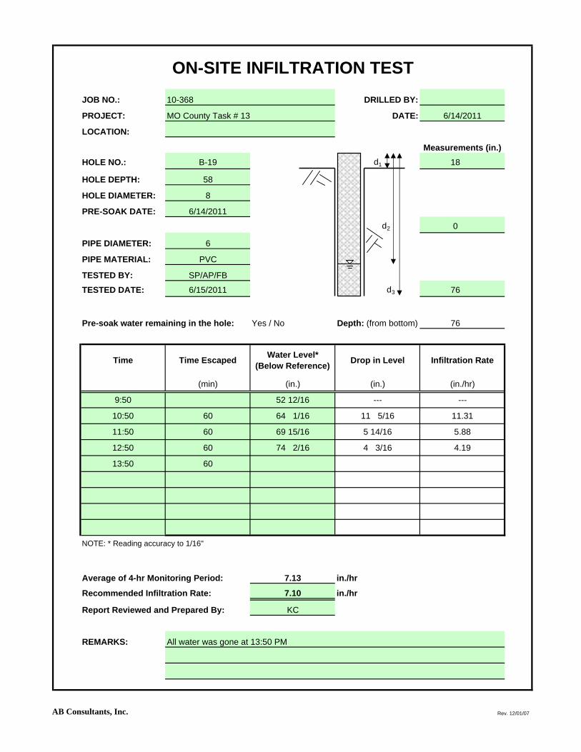
ON-SITE INFILTRATION TESTJOB NO.: 10-368 DRILLED BY:
PROJECT: MO County Task # 13 DATE: 6/14/2011
LOCATION:
Measurements (in.)HOLE NO.: B-19 d1 18
HOLE DEPTH: 58
HOLE DIAMETER: 8
PRE-SOAK DATE: 6/14/2011
d2 0
PIPE DIAMETER: 6
PIPE MATERIAL: PVC
TESTED BY: SP/AP/FB
TESTED DATE: 6/15/2011 d3 76
Pre-soak water remaining in the hole: Yes / No Depth: (from bottom) 76
Time Time Escaped Water Level* (Below Reference) Drop in Level Infiltration Rate
(min) (in.) (in.) (in./hr)
9:50 52 12/16 --- ---
10:50 60 64 1/16 11 5/16 11.31
11:50 60 69 15/16 5 14/16 5.88
12:50 60 74 2/16 4 3/16 4.19
13:50 60
NOTE: * Reading accuracy to 1/16"
Average of 4-hr Monitoring Period: 7.13 in./hr
Recommended Infiltration Rate: 7.10 in./hr
Report Reviewed and Prepared By: KC
REMARKS: All water was gone at 13:50 PM
AB Consultants, Inc. Rev. 12/01/07

ON-SITE INFILTRATION TESTJOB NO.: 10-368 DRILLED BY:
PROJECT: MO County Task # 13 DATE: 6/14/2011
LOCATION:
Measurements (in.)HOLE NO.: B-20 d1 7
HOLE DEPTH: 69
HOLE DIAMETER: 8
PRE-SOAK DATE: 6/14/2011
d2 55 7/8
PIPE DIAMETER: 6
PIPE MATERIAL: PVC
TESTED BY: SP/AP/FB
TESTED DATE: 6/15/2011 d3 76
Pre-soak water remaining in the hole: Yes / No Depth: (from bottom) 20 1/8
Time Time Escaped Water Level* (Below Reference) Drop in Level Infiltration Rate
(min) (in.) (in.) (in./hr)
9:00 50 8/16 --- ---
10:00 60 50 15/16 7/16 0.44
11:00 60 51 8/16 9/16 0.56
12:00 60 52 1/16 9/16 0.56
13:00 60 52 8/16 7/16 0.44
NOTE: * Reading accuracy to 1/16"
Average of 4-hr Monitoring Period: 0.50 in./hr
Recommended Infiltration Rate: 0.50 in./hr
Report Reviewed and Prepared By: KC
REMARKS:
AB Consultants, Inc. Rev. 12/01/07

ON-SITE INFILTRATION TESTJOB NO.: 10-368 DRILLED BY:
PROJECT: MO County Task # 13 DATE: 6/14/2011
LOCATION:
Measurements (in.)HOLE NO.: B-21 d1 24
HOLE DEPTH: 72
HOLE DIAMETER: 8
PRE-SOAK DATE: 6/14/2011
d2 91 5/8
PIPE DIAMETER: 6
PIPE MATERIAL: PVC
TESTED BY: SP/AP/FB
TESTED DATE: 6/15/2011 d3 96
Pre-soak water remaining in the hole: Yes / No Depth: (from bottom) 4 3/8
Time Time Escaped Water Level* (Below Reference) Drop in Level Infiltration Rate
(min) (in.) (in.) (in./hr)
9:10 70 14/16 --- ---
10:10 60 72 8/16 1 10/16 1.63
11:10 60 74 1 8/16 1.50
12:10 60 75 2/16 1 2/16 1.13
13:10 60 76 1/16 15/16 0.94
NOTE: * Reading accuracy to 1/16"
Average of 4-hr Monitoring Period: 1.30 in./hr
Recommended Infiltration Rate: 1.30 in./hr
Report Reviewed and Prepared By: KC
REMARKS:
AB Consultants, Inc. Rev. 12/01/07

ON-SITE INFILTRATION TESTJOB NO.: 10-368 DRILLED BY:
PROJECT: MO County Task # 13 DATE: 6/14/2011
LOCATION:
Measurements (in.)HOLE NO.: B-22 d1 12
HOLE DEPTH: 36
HOLE DIAMETER: 8
PRE-SOAK DATE: 6/14/2011
d2 37 1/8
PIPE DIAMETER: 6
PIPE MATERIAL: PVC
TESTED BY: SP/AP/FB
TESTED DATE: 6/15/2011 d3 48
Pre-soak water remaining in the hole: Yes / No Depth: (from bottom) 10 7/8
Time Time Escaped Water Level* (Below Reference) Drop in Level Infiltration Rate
(min) (in.) (in.) (in./hr)
9:10 23 --- ---
10:10 60 23 11/16 11/16 0.69
11:10 60 24 7/16 12/16 0.75
12:10 60 25 4/16 13/16 0.81
13:10 60 26 12/16 0.75
NOTE: * Reading accuracy to 1/16"
Average of 4-hr Monitoring Period: 0.75 in./hr
Recommended Infiltration Rate: 0.75 in./hr
Report Reviewed and Prepared By: KC
REMARKS:
AB Consultants, Inc. Rev. 12/01/07

ON-SITE INFILTRATION TESTJOB NO.: 10-368 DRILLED BY:
PROJECT: MO County Task # 13 DATE: 6/14/2011
LOCATION:
Measurements (in.)HOLE NO.: B-23 d1 24
HOLE DEPTH: 64
HOLE DIAMETER: 8
PRE-SOAK DATE: 6/14/2011
d2 0
PIPE DIAMETER: 6
PIPE MATERIAL: PVC
TESTED BY: SP/AP/FB
TESTED DATE: 6/15/2011 d3 88
Pre-soak water remaining in the hole: Yes / No Depth: (from bottom) 88
Time Time Escaped Water Level* (Below Reference) Drop in Level Infiltration Rate
(min) (in.) (in.) (in./hr)
9:40 59 7/16 --- ---
10:40 60 78 4/16 18 13/16 18.81
11:40 60 83 4/16 5 5.00
12:40 60 84 5/16 1 1/16 1.06
13:40 60 85 3/16 14/16 0.88
NOTE: * Reading accuracy to 1/16"
Average of 4-hr Monitoring Period: 6.44 in./hr
Recommended Infiltration Rate: 6.45 in./hr
Report Reviewed and Prepared By: KC
REMARKS: Water became muddy at the last three readings
AB Consultants, Inc. Rev. 12/01/07

ON-SITE INFILTRATION TESTJOB NO.: 10-368 DRILLED BY:
PROJECT: MO County Task # 13 DATE: 6/15/2011
LOCATION:
Measurements (in.)HOLE NO.: B-24 d1 13
HOLE DEPTH: 68
HOLE DIAMETER: 8
PRE-SOAK DATE: 6/15/2011
d2 67 4/9
PIPE DIAMETER: 6
PIPE MATERIAL: PVC
TESTED BY: SP/FB
TESTED DATE: 6/16/2011 d3 81
Pre-soak water remaining in the hole: Yes / No Depth: (from bottom) 13 4/7
Time Time Escaped Water Level* (Below Reference) Drop in Level Infiltration Rate
(min) (in.) (in.) (in./hr)
8:40 56 2/16 --- ---
9:40 60 57 12/16 1 10/16 1.63
10:40 60 59 1/16 1 5/16 1.31
11:40 60 59 9/16 8/16 0.50
12:40 60 59 12/16 3/16 0.19
NOTE: * Reading accuracy to 1/16"
Average of 4-hr Monitoring Period: 0.91 in./hr
Recommended Infiltration Rate: 0.90 in./hr
Report Reviewed and Prepared By: KC
REMARKS:
AB Consultants, Inc. Rev. 12/01/07
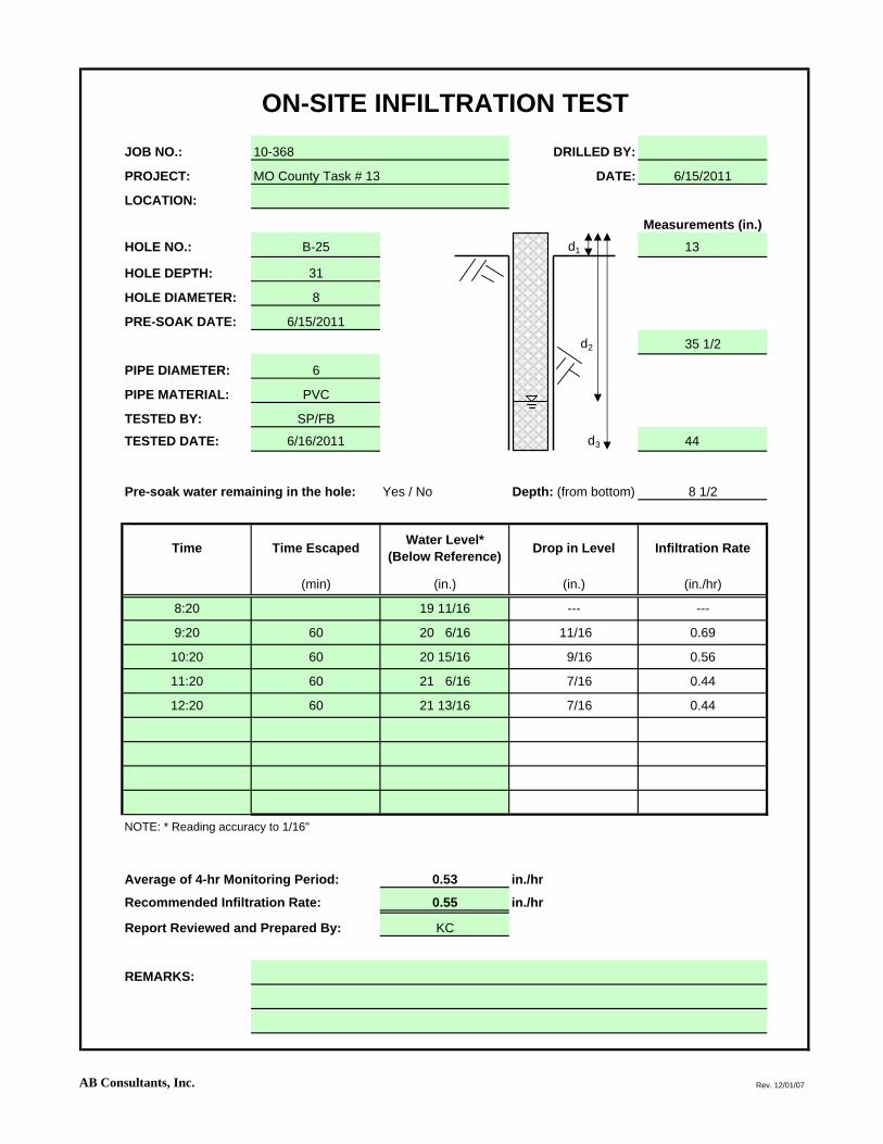
ON-SITE INFILTRATION TESTJOB NO.: 10-368 DRILLED BY:
PROJECT: MO County Task # 13 DATE: 6/15/2011
LOCATION:
Measurements (in.)HOLE NO.: B-25 d1 13
HOLE DEPTH: 31
HOLE DIAMETER: 8
PRE-SOAK DATE: 6/15/2011
d2 35 1/2
PIPE DIAMETER: 6
PIPE MATERIAL: PVC
TESTED BY: SP/FB
TESTED DATE: 6/16/2011 d3 44
Pre-soak water remaining in the hole: Yes / No Depth: (from bottom) 8 1/2
Time Time Escaped Water Level* (Below Reference) Drop in Level Infiltration Rate
(min) (in.) (in.) (in./hr)
8:20 19 11/16 --- ---
9:20 60 20 6/16 11/16 0.69
10:20 60 20 15/16 9/16 0.56
11:20 60 21 6/16 7/16 0.44
12:20 60 21 13/16 7/16 0.44
NOTE: * Reading accuracy to 1/16"
Average of 4-hr Monitoring Period: 0.53 in./hr
Recommended Infiltration Rate: 0.55 in./hr
Report Reviewed and Prepared By: KC
REMARKS:
AB Consultants, Inc. Rev. 12/01/07

ON-SITE INFILTRATION TESTJOB NO.: 10-368 DRILLED BY:
PROJECT: MO County Task # 13 DATE: 6/15/2011
LOCATION:
Measurements (in.)HOLE NO.: B-26 d1 12
HOLE DEPTH: 54
HOLE DIAMETER: 8
PRE-SOAK DATE: 6/15/2011
d2 0
PIPE DIAMETER: 6
PIPE MATERIAL: PVC
TESTED BY: SP/FB
TESTED DATE: 6/16/2011 d3 66
Pre-soak water remaining in the hole: Yes / No Depth: (from bottom) 66
Time Time Escaped Water Level* (Below Reference) Drop in Level Infiltration Rate
(min) (in.) (in.) (in./hr)
8:30 19 11/16 --- ---
9:30 60 20 6/16 11/16 0.69
10:30 60 20 15/16 9/16 0.56
11:30 60 21 6/16 7/16 0.44
12:30 60 21 13/16 7/16 0.44
NOTE: * Reading accuracy to 1/16"
Average of 4-hr Monitoring Period: 0.53 in./hr
Recommended Infiltration Rate: 0.55 in./hr
Report Reviewed and Prepared By: KC
REMARKS:
AB Consultants, Inc. Rev. 12/01/07

ON-SITE INFILTRATION TESTJOB NO.: 10-368 DRILLED BY:
PROJECT: MO County Task # 13 DATE: 6/15/2011
LOCATION:
Measurements (in.)HOLE NO.: B-27 d1 20
HOLE DEPTH: 67
HOLE DIAMETER: 8
PRE-SOAK DATE: 6/15/2011
d2 0
PIPE DIAMETER: 6
PIPE MATERIAL: PVC
TESTED BY: SP/FB
TESTED DATE: 6/16/2011 d3 87
Pre-soak water remaining in the hole: Yes / No Depth: (from bottom) 87
Time Time Escaped Water Level* (Below Reference) Drop in Level Infiltration Rate
(min) (in.) (in.) (in./hr)
8:50 57 9/16 --- ---
9:50 60 59 9/16 2 2.00
10:50 60 61 1 7/16 1.44
11:50 60 62 1/16 1 1/16 1.06
12:50 60 63 3/16 1 2/16 1.10
NOTE: * Reading accuracy to 1/16"
Average of 4-hr Monitoring Period: 1.40 in./hr
Recommended Infiltration Rate: 1.40 in./hr
Report Reviewed and Prepared By: KC
REMARKS:
AB Consultants, Inc. Rev. 12/01/07

ON-SITE INFILTRATION TESTJOB NO.: 10-368 DRILLED BY:
PROJECT: MO County Task # 13 DATE: 6/15/2011
LOCATION:
Measurements (in.)HOLE NO.: B-28 d1 22
HOLE DEPTH: 60
HOLE DIAMETER: 8
PRE-SOAK DATE: 6/15/2011
d2 0
PIPE DIAMETER: 6
PIPE MATERIAL: PVC
TESTED BY: SP/FB
TESTED DATE: 6/16/2011 d3 82
Pre-soak water remaining in the hole: Yes / No Depth: (from bottom) 82
Time Time Escaped Water Level* (Below Reference) Drop in Level Infiltration Rate
(min) (in.) (in.) (in./hr)
9:00 54 7/16 --- ---
10:00 60 56 15/16 2 8/16 2.50
11:00 60 59 4/16 2 5/16 2.31
12:00 60 62 2 12/16 2.75
13:00 60 63 12/16 1 12/16 1.75
NOTE: * Reading accuracy to 1/16"
Average of 4-hr Monitoring Period: 2.33 in./hr
Recommended Infiltration Rate: 2.30 in./hr
Report Reviewed and Prepared By: KC
REMARKS:
AB Consultants, Inc. Rev. 12/01/07