Geo-informatics of Multi-scale Solutions in Navier-Stokes ...
Monitoring Shoreline Change Using Geo-Informatics: A Case Study at Chalatat Beach in Songkhla Province, Thailand
Aekkarak FAIBOONa Siriporn PRADITa and Sompratana RITPHRINGb
a Marine and Coastal Resources Institute, Prince of Songkhla University, Hatyai, Songkhla, Thailand; Tel: +66(0)-7421-2800; Fax. +66(0)-7421-2782;
E-mail :[email protected] E-mail :[email protected]
b Department of Water Resources Engineering, Kasetsart University, Jatujak, Bangkok, Thailand; Tel: +66(0)-2579-1567; Fax. +66(0)-2579-1567; E-mail: [email protected]
Abstract Thailand has 2,614 kilometers of coastline. Over 12 million people who live along the coast are facing the erosion of shore. Coastal erosion is hot an issue in Thailand. The shoreline is confronting severe coast erosion. Erosion rate in some area is critical. Songkhla province has been facing coastal erosion problem at every districts near coast. This research aims to monitor the shoreline change by using Geo-informatics and collect shoreline change database for planer decision support system. This research studied about the information of shoreline changing by using the 7 datasets of aerial photographs and satellite images had taken in 1967, 1974, 1989, 1995, 2002, 2007 and 2011. The Image process; geometric correction and image enchantment by Erdas Imagine Version 9.1 program, the shoreline change analysis using GIS overlay technique, Especially, In the results, Net shoreline change after construct hard structure on the coastal area. The northward of the T-groin on the Songkhla Naval Base front beach area approximately 2.3 kilometers of shore, erosion rate in moderately level (1- 5 meter/year). On the other hand, on the downdrift of the jetty on the Songkhla lake mouth at Son On cape on Samila beach area is accretion of sand. The causes of coastal erosion come from human activities. Using high-resolution image data several times able to monitor coastal effectively. Therefore, Coastal erosion problems should not obscure landscape view. Consequently, Soft solution such as beach nourishment and sand bypass is the right choice. To reduce the wave energy action on the shore, Because, Chalatat beach is popular attraction place for the tourists who come and visit Songkhla province. This process can be should sustainable solution approach for coastal zone management. Keywords: Shoreline Change, Coastal Erosion, Geo-Informatics, Remote Sensing, High
Resolution Image, Songkhla

1. Introduction 1.1 Situation of Coastal area in Thailand Thailand has 2,614 kilometers of coastline. Over 12 million people who live along the coast are facing the erosion of shore.
Coastal erosion is a hot issue in Thailand, Along the Coasts nearly 600 kilometers (22.50 % of total shoreline of Thailand) of shoreline is confronting severe coastal erosion. Erosion rates in some area more than 25 meter/year. Coastal erosion causes land lost and Coastal Resource deterioration. (Department of Marine and Coastal Resources, 2010) As the World Bank in 2007 estimated that Thai coastal land has been lost 2 kilometer2 per year with the damage of 6 Billion Baht. (Siripong, 2010) and The loss of economic value, especially the Gulf of Thailand Provinces approximately 28,317 Baht (Sirisup, 2010). The current government has given priority coastal erosion is a problem that disaster a National Agenda. (Vejjajiva &
Kunkitti, 2010) 1.2 Situation of Coastal Change in Songkhla
Songkhla province has 158 kilometers of coastline. Coastal erosion is a problem with the length of approximately 54.5 kilometers. (Department of Marine and Coastal Resources, 2010)
Erosion along Songkhla beach has been reporting since 1995, with the beach retreating from 0.5-8 meters/year. During 1968-1989, the width of Ban Koa Seng beach, south of Songkhla. After constructing the oil-tanker pier, the coastal erosion has become more serious and half at the beach lost in 6 years, during 1989-1995. The latest work by Ritphring (2002). indicates that the coastal engineering structures causes severe erosion along the coastline (Pornpinatepong, Tanaka & Chittrakarn 2005). 1.3 Coastal processes
Coastal process is a change of physical characteristic of coastline that function is different into geological process. The coastal erosion in Thailand can be divided into three types: erosion, deposition and stable shoreline.
These coastlines are developed and change in both physical and biological aspects that have two major causes natural processes and human activities (Arunrat, 2009).
The coastline changes occur along 162 kilometers of Songkhla coast. The 7 areas 23.4 kilometers in length are erosional and areas are severely erosional. In addition, 3 areas (4.7 kilometers in length) are depositional and the rest 133.9 kilometers are stable (Bennui, Rattanamanee, Limjirakhajorn, Phutmongkhon, & Yongsathitsak, 2010). The study of coastline changes by Department of Mineral Resources in 2002 show the decrease of coastal erosion and deposition and the increase of stable coast (Sinsakul et al. 2003)
The Longshore sediment transport of the Southern Eastcoast Gulf of Thailand, the net sediment moves from northward to Leam Talumpuk. The estimation of longshore sediment transportation rate in Songkhla shoreline is about 200,000 m3/year (Pornpinatepong, Tanaka & Chittrakarn, 2005). 1.4 What is Geo-Informatics?
Geo-Informatics or 3S technology is the science and the technology which develops and uses information science infrastructure to ad- dress the problems of geography, geosciences and related branches of engineering. (figure 1).
Remote Sensing (RS) is the science of deriving information about an object from measurements made at a distance from the object without coming into contact with it Global. Global Positioning System (GPS) is the only fully functional Global Navigation Satellite System (GNSS). The GPS uses a constellation of between 24 and 32 Medium Earth Orbit satellites that transmit precise microwave signals, that enable GPS receivers to determine their location, speed, direction, and time. http://en.wikipedia.org/wiki/Geo informatics) Geographic Information System (GIS) is a integrates hardware, software, and data for capturing, managing, analyzing, and displaying all forms of geographically referenced

information.(http://www.gis.com/content/what-gis)
Figure 1: Geo-Informatics. Adapted from GISTDA(2009)
1.5 Geo-Informatics for shoreline change monitoring.
Remote Sensing data can be used in environmental monitoring. Khaldoun and Irmgard (2009). Studied title Coastal Monitoring Using Remote Sensing and Geoinformation Systems: to estimate theerosion and accretion rates along Gaza Coastline. The study used three different sets of images: LANDSAT- ETM images, LANDSAT-TM-5 and SPOT-5. The accuracy between these different methods were investigated by manually digitized and automatically extracted of coastlines from all images. The rate of change was calculated between 1986 and 2008. The result indicates accretion rate and rate erosion rate in the area.
Using high-resolution satellite image data to monitor the shoreline change, Zhang et al.(2008) studied the remote sensing on coastal zone and island in China by Using IKONOS Sattellite images. detected coastline and coastal zone construction.
Chalabi et al. (2006) studied shoreline change using IKONOS Image and Aerial Photographs: in Kuala Terengganu Area, Malaysia, and proposed segmentation method
to extract the shoreline. The results revealed that there is a greatest value of accretion over 38 years.
In 2011, Wandao investigated the shoreline change and monitored the coastal erosion solving using Geo-informatics in Pak Phanang Basin, Nakhon Si Thammarat Province. the aerial photograph in 1974, 1995, and 2002. The images of SPOT-5 in 2005 and the images of THEOS in 2009. Were used the shoreline change has been studies during 1974-1995. It was found that the coastal erosion area was 478,121.09 meters2. In 1995-2002, the coastal erosion area was 326,839.36 meters2. In 2002-2005, the coastal erosion area was 158,838.43 meters2. In 2005-2009, the coastal erosion area was 335,958.42 meters2. The findings show that the shoreline change is likely to occur more erosional than depositional and the solution of coastal erosion.
The problem in this regard requires accurate information as tools for decision-making. The monitoring of Coastal Change using Geo-Informatics is very important, for spatial area information timely and can be use in the management plan to solve the problem
and most effectively. 1.6 Objectives
The objective this research, aim to monitoring shoreline change by using Geo-informatics and collect shoreline change database for planer decision support system.
2. Study area and Methodology 2.1 Study area Chalatat beach coastal system located in Songkla City Municipal, Muang District, Songkhla Province. The coastline starts from jetty at Son On Cape on Samila beach to Chalatat beach and Hua Nai Rang rock. The beach length is approximately 8 Kilometers. (figure 2).
Figure 2: The study area
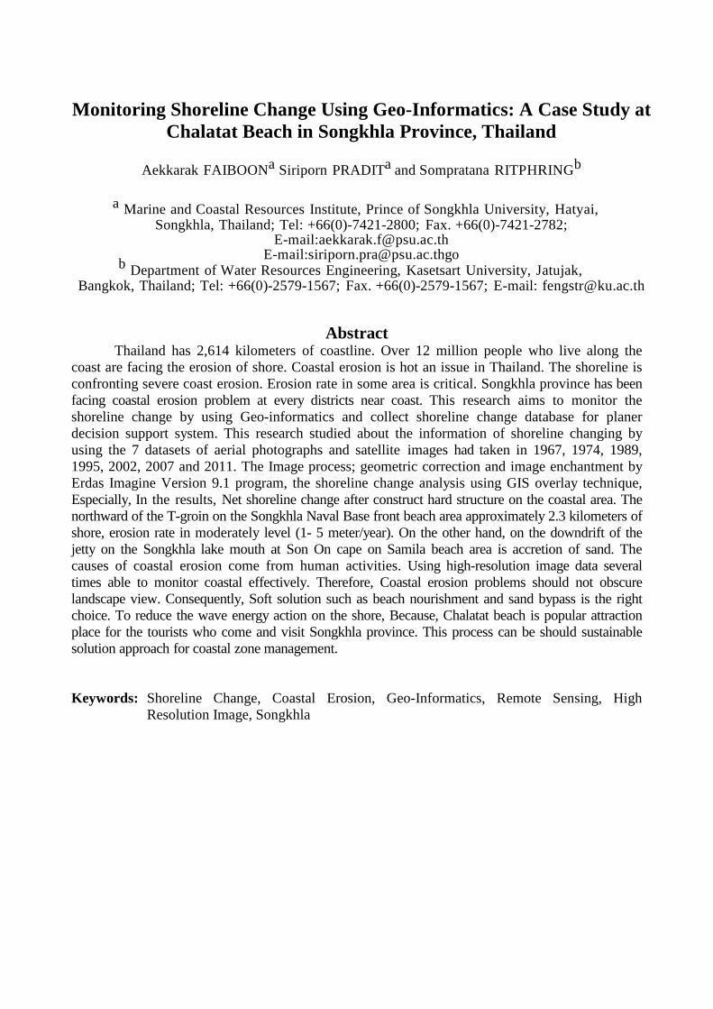
2.2 Method This research used the 6 data sets of aerial photographs and satellite images taken before and after the construction of the reclaimed land during 1967 and 2011 and interpreted the coastline change by image difference method.
Data used in this study was acquired from different sources covering Chalatat beach coastal system area such as
• Aerial Photographs data scale of 1:15,000 and 1:4,000 acquired on 1967, 1974, 1989, 1995 and 2002
• Satellite Images data from SPOT-5 and THEOS resolution 2.0-2.5 meters taken during 2007, 2009 and 2011 The Image process; Geometric
Correction of Aerial Photographs and Satellite Images data was carried out using ERDAS IMAGINE Version 9.1 with WGS84 projection system. The geometric correction was image to image technique. The rectified image, which has been through Ortho-
Rectification process, has been used as the reference image. Ground control points were set for at least 16 points per image, and these points need to be spread all over the image. The image was rectified with an equation of polynomial level 2. RMS Error was set to be not more than 1 pixel. Nearest Neighbor was used as a resampling method. The output image was set to have a resolution of 1x1 meter.(Sangrawee & Rungsipanich, 2010)
Digitization of shoreline on screen Shorelines were digitized using Arcview GIS Version 3.3 program. The defined shoreline perimeter of the coast was digitized on screen from the aerial photo and satellite images (Khaldoun & Irmgard, 2009)
In this study, the shoreline change were detected by using GIS overlay technique. The aerial photograph from the years 1966, 1974, 1989 and 1995 and Satellite Image SPOT-5, THEOS from the years 2007, 2009 and 2011 were used for detecting the shoreline change. (figure 3.)
Figure3: The procedure of Geo-informatics analysis.
Aerial photograph
Geometric Correction
Image Enhancement
Data Analysis
Image Interpretation (Digitize on Screen)
Result in Erosion & Accretion Map
Overlay Vector Layer
Satellite Images
Songkhla
Study area
Gulf of Thailand

The GIS process, calculate the change in the coastal areas has been divided into sub-areas and the rate of the shoreline change was calculated. (figure 4)
Figure4: Showing sub-areas for calculate rate of the shoreline change.
Shoreline changes during 45 years
period can be identified by the overlaying the shoreline aerial photographs taken in 1966 with THEOS PAN Sharpened satellite images taken during 2011. The erosion rate is determined by overlaying the distance perpendicular with a shoreline divided by the number of years used in the comparison (e.g. 1995-2002 = 7 years). The overlaying distance perpendicular with the shoreline can be established by calculation from the division of the eroded areas with the eroded distance in each area. (figure 5.) The outcome of the calculation can be used to classify coastal changes in accordance with the criteria specified by the Department of Mineral Resources (Sinsakul et al., 2002) as following.
- Severely erosional coasts with an erosion rate of > 5 meters/year;
- Moderately erosional coast with an erosion rate of 1-5 meters/year;
- Accretional coast with a deposition rate of 1-5 meters/year;
- Stable coast with a change rate of ± 1 meter/year
Figure5: Calculation for rates of coastal
change. Adapted from Bennui, et al,. (2008).
3. Results and Discussions The analysis of the shoreline changes in Chalathat Beach and adjacent area were investigate, 7 dataset aerial photos and satellite images from 1966 - 2011 as a period of 45 years were used. (figure 6-8) 3.1 Samila Beach(Son On Cape-Mermaid).
The Samila beach area start from jetty southward of songkhla lake moth to natural headland (Mermaid Sculpture). The beach length is approximately 2.8 Kilometers. the coastal area has been changing as following. 1966-1974 The analysis on the shoreline change between 1966 and 1974 is shown in figure 6. There was less accretion area 41,904.60 meters2. The effect of the 640 meters jetty construction at Son On Cape, mouth of Songkhla Lake in 1968 by Port Authority of Thailand is blocking the sediments transport and causes sediment deposition along southward of the jetty. Because of longshore sediment transport of the Southern Eastcoast Gulf of Thailand, the net sediment moves to

northward (Padchawee, 2010). Sediment movement against the structure perpendicular to the shoreline sands will be detained, consistent with the report of Kawamura and Tanaka(2005) reporting direction of longshore sediment transport is southward, Is in the same direction and sediment is strapped drowndrift jetty. Benui, Ratanamanee and Kampeera(2009) report that this area has increased from continuous deposition of sediments. 1974-1989 The accretion area was increasing to 380,404.92 meters2. due to extended to 940 meters in 1985. Consistent with the report of Pornpinatepong, Tanaka and Chittrakarn (2005). The jetty affected the longshore transport of sand in such a way that the beach south of it gained and moved seawards due to accretion. 1989-1995
Figure 6 also shows the shoreline change between 1989 and 1995. The accretion area reaches 122,106.90 meters2 of sand at the lower side of the jetty on Songkhla Lake mouth. However, the accretion is constantly expanding with sand trap 940 meters out of the jetty, resulting in a sand trap. Consistent with the report of Benui, Ratanamanee and Kampeera(2009) The coastal area is becoming steadily. 1995-2007
From SPOT PAN Sharpened data analysis, about more than 5 sq.km./year of change rate were accretion area of 114,366.21 meters2. 2007-2009
From THEOS PAN Sharpened data analysis, during 2007-2009 about more than 5 sq.km./year of change rate were accretion area 108,102.10 meters2.
2009-2011
From THEOS PAN Sharpened data analysis, during 2009-2011about more than 5 sq.km./year of change rate were accretion area 43,319.08 meters2.
3.2 Chalatat Beach (Mermaid- Hua Nai Rang rock)
The Chalatat beach area start from natural head land southward of Mermaid Sculpture to natural head land (Hua Nai Reng rock), The beach length is approximately 5 Kilometers. This study found that the coastal area change is as follows. 1966-1974
Aerial photographs data analysis during 1966-1974 shown net of shoreline change has accretion area 128,942.52 meters2. 1974-1989
The data analysis during 1974 and 1989 shown accretion in this area 23,566.73 meters2 1989-1995
During 1989 and 1995, erosion in this area was 11,615.409 meters2. It is not eroded from man-made, but, it caused by natural phenomena. Due to the nationality of Panama ran aground on the north side of the Khao Seng community area, the causing erosion downstream and accretion upstream. However, the ship which ran aground perpendicular to the coast in the south-east monsoon season (Oct. - Mar) the wave to that hit the ship causes with sediment deposition along the upstream and downstream and the erosion occurs. According to the report of Benui, Ratanamanee and Kampeera(2009) found that there is sediment deposition southward and erosion northward of the vessel. 1995-2007 There was considerable shoreline change in this area from 1995 to 2007. There was less eroded in area 69,531.60 meters2 (rate of change 1.65 kilometers2./year). the major is anthropogenic sewage pumping station structure on the coastal area at Khao Seang Community in 2001 and the construction of the T-Groin in 2002 and other structures order to control shoreline erosion at Chalatat beach. However, due to the hard structure located perpendicular to the shore on the waves will cause diffraction detained at the upstream and downstream and cause the erosion.

Figure 6: Shoreline change 1967-2011
Shoreline Shoreline Shoreline Shoreline Shoreline Shoreline Shoreline Shoreline

Figure 7: Rates of shoreline changes 1967- 2011.
Figure 8: History of coastal change and coastal protection in study area. (www.oknation.net and Faiboon,A.)
2007-2009
From THEOS PAN Sharpened data analysis, during 2007-2009 approximate erosion was 8,632.15 meters2 (3.73 kilometers2/year). This is due to several agencies did some solutions with hard structure i.e Riprap, Gabion Seawall and Sand Bag However, the beach still deteriorate by wave and current. According to the report of Ritphring and Tanaka (2010) and Wandao(2011) found that there sediment is
trapped font of hard structure on coastal area. 2009-2011
From THEOS PAN Sharpened data analysis, during 2009-2011 about more than 5 sq.km./year of change rate were eroded 17,435.12 meters2. Because, the agency still solved the problem by hard structure, therefore have continuous erosion. Consistent with the report of Muslim, Ismail, Khalil, Razman and Zain(2008) the main reason of erosion due to interruption of sediment transport. 4. Conclusions and Recommendation
In Conclusion, high-resolution image data is able to monitor shoreline change effectively. In addition, The tide data shown be included to make it more accurate and more complete data analysis. The frequent data images are need for more detail of shoreline
1995 2002
2004
2011
2011
2012
2012 2012

change. Obviously, the major cause of the erosion is anthropogenic hard structure construction. Coastal erosion cause by lack of equilibrium of sediments. Sediment transport out of the area by waves and longshore current. While, the sediment is insufficient to renew the beach. Consequently, solution should be the right choice. Soft solution such as beach nourishment and sand bypass are the right way in this area to reduce the wave energy action on the shore the most important, Chalatat beach is popular attraction place for the tourists who come and visit Songkhla province. The appropriate solution of coastal zone management for sustain the beach is need. 5. Acknowledgement
We appreciate the Prince of Songkla University Graduate School to support funding research and Geo-Informatics and Space Technology Development Agency (Public Organization) (GISTDA), Ministry of Science and Technology, Thailand to support the aerial photograph and satellite images data.
Committee on Marine and Coastal Resources Management thesis and Marine and Coastal Resources Institute (MACORIN), Prince of Songkla University give advises knowledge.
6. References Arunrat, N. (2008). Coastal Erosion Related to Hydro-Metrological Regimes at Pak Phanang Bay, Nakhon Sri Thammarat Province. Thesis. Thammasat Univer- sity. Bennui, A., et al,. (2008). Coastal Change Application of Geo-Informatics on Monitoring of the East Coast of the Thailand Peninsular. Exclusive Sum- mary Report. GISTDA. Bennui, A., Rattanamanee, & Anan. K. (2009). Coastal Change Monitoring in Smila Beach Songkhla Province via the use of Application of Geo-Informatics. GISTDA Seminar. Songkhla. Thailand. Bennui, A., Rattanamanee, P; Limjirakhajorn, Phutmongkhon, Y, P; & Yongsa- thitsak. T. (2010). Application of Geo-
Informatics System on Coastal Erosion Monitoring of East Coast of the Thai Southern Peninsular. The 8th Interna- tional Symposium on Southeast Asian Water Environment. Phuket. Thailand. Department of Marine and Coastal Resources. (2010). Management strategies to pre- vent and solve the problems of coastal erosion. Proceedings of International Symposium on Sea Level Rise and Coastal Erosion. Bangkok. Thailand. GISTDA(Geo-Informatics and Space Techno- logy Development Agency (Public Or- ganization)). (2009). Geo-Informatics. Bangkok. Kawamura A. & Hatochi.T (2005). Asian and Pacific Coast 2005, Jeju, Korea. Khaldoun, A. A. & Irmgard, N. (2009). Coastal Monitoring Using Remote Sensing and Geoinformation Systems: Estimation of Erosion and Accretion Rates Along Gaza Coastline. IEEE. International Geoscience Remote Sensing. Sypo- sium (IGRASS) 2009. Muslim. A.M, Ismai. K.I, Khalil. I., Razman. N. and Zain. K. 2008. Dection of Shoreline Change at Kuala Terngganu, Malaysia from Multi- temporal Sattlelite Sensor Imagery. International Society for Photo- grammetry and Remote Sensing. Ritphring, S. (2002). Shoreline Changes at Pak Phanang River Basin. (master’s thesis) Chulalongkorn University, Thailand. (In Thai). Ritphring, S. & Hatochi.T. (2010). Morpho- Variability in the Vicinity of Coastal Structures. Proceedings of 32nd Conference on Coastal Engineering, Shanghai, China Sinsakul, S. et al. (2002). Coastal Changes on the East Coast of Thailand. Geology Division, Department of Mineral Re- sources. (In Thai).

Siripong, A. (2010). Detect the Coastline Change in Thailand by Remote Sensing. International Archives of the Photogrammetry, Remote Sensing and Spatial Information Science, Volume XXXVIII, Part 8, Kyoto, Japan. Sirisup, S. (2009). Simulation of Coast Change in Thailand. (online). Available at http:// goc.pragma-grid.net. [accessed on 20 September 2010]. Sirisup, S. (2009). Simulation of Coast Change in Thailand( Phase I). (online). Availa- ble at http://service.nectec.or.th/ project0/pgShowPrj.php? chrFlg01= 1&chvCodPrj=LM5201&color=brow [accessed on 20 September 2010]. (In Thai). Pornpinatepong, S., Tanaka, H., & Chittra- karn. T. (December, 2005). Coastal Dynamics and Shore Erosion in Song- khla. The Fourth OMISAR Workshop on Ocean Model. Faculty of Engineer- ing Prince of Songkhla University. Songkhla, Thailand. Sangrawee, P; & Rungsipanich. A. (November, 2010). Application of Remote Sensing for Monitoring Land Use Change in Songkhla Lake at Songkhla province, Thailand. The 31st Asian Conference on Remote Sensing 2010. Hanoi, Vietnam. Vejjajiva, A. & Kunkitti S.. (2010). Environ- mental treatment held in a bid to hand- le critical coastal erosion. Journal. 8 (35),25-33. (In Thai). Wandao, S. (2011). Study on Shoreline Chan- ge and Monitoring of Coastal Erosion Solving Using Geo-informatics in Pak Phanang Basin, Nakhon Si Thammarat Province. (master’s thesis) Prince of Songkla University, Thailand. (In Thai). Zhang et al.(2008). The Remote Sensing Studies on Coastal Zone and Island in China by Using IKONOS Satellite images. http://www.gis.com/content/what-gis http://en.wikipedia.org/wiki/Geo informatics