Molluscan Shellfish Production Areas, Sample Points … · Molluscan Shellfish Production Areas,...
169
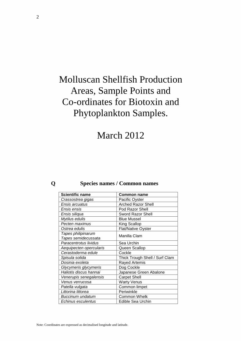
2 Note: Coordinates are expressed as decimalised longitude and latitude. Molluscan Shellfish Production Areas, Sample Points and Co-ordinates for Biotoxin and Phytoplankton Samples. March 2012 Q Species names / Common names Scientific name Common name Crassostrea gigas Pacific Oyster Ensis arcuatus Arched Razor Shell Ensis ensis Pod Razor Shell Ensis siliqua Sword Razor Shell Mytilus edulis Blue Mussel Pecten maximus King Scallop Ostrea edulis Flat/Native Oyster Tapes philipinarum Tapes semidecussata Manilla Clam Paracentrotus lividus Sea Urchin Aequipecten opercularis Queen Scallop Cerastoderma edule Cockle Spisula solida Thick Trough Shell / Surf Clam Dosinia exoleta Rayed Artemis Glycymeris glycymeris Dog Cockle Haliotis discus hannai Japanese Green Abalone Venerupis senegalensis Carpet Shell Venus verrucosa Warty Venus Patella vulgata Common limpet Littorina littorea Periwinkle Buccinum undatum Common Whelk Echinus esculentus Edible Sea Urchin
Transcript of Molluscan Shellfish Production Areas, Sample Points … · Molluscan Shellfish Production Areas,...
2
Note: Coordinates are expressed as decimalised longitude and latitude.
Molluscan Shellfish Production Areas, Sample Points and
Co-ordinates for Biotoxin and Phytoplankton Samples.
March 2012
Q Species names / Common names
Scientific name Common name Crassostrea gigas Pacific Oyster Ensis arcuatus Arched Razor Shell Ensis ensis Pod Razor Shell Ensis siliqua Sword Razor Shell Mytilus edulis Blue Mussel Pecten maximus King Scallop Ostrea edulis Flat/Native Oyster Tapes philipinarum Tapes semidecussata Manilla Clam
Paracentrotus lividus Sea Urchin Aequipecten opercularis Queen Scallop Cerastoderma edule Cockle Spisula solida Thick Trough Shell / Surf Clam Dosinia exoleta Rayed Artemis Glycymeris glycymeris Dog Cockle Haliotis discus hannai Japanese Green Abalone Venerupis senegalensis Carpet Shell Venus verrucosa Warty Venus Patella vulgata Common limpet Littorina littorea Periwinkle Buccinum undatum Common Whelk Echinus esculentus Edible Sea Urchin
3
Note: Coordinates are expressed as decimalised longitude and latitude.
Production Area Maps Table of Content Lough Foyle ................................................................................................................... 7 Tra Breaga ...................................................................................................................... 8 Lough Swilly .................................................................................................................. 9 Mulroy Bay .................................................................................................................. 10 Sheephaven .................................................................................................................. 11 Ballyness Harbour ........................................................................................................ 12 Burtonport .................................................................................................................... 14 Arranmore .................................................................................................................... 15 Dungloe ........................................................................................................................ 16 Tra Eananch ................................................................................................................. 17 Gweebarra .................................................................................................................... 18 Loughras More ............................................................................................................. 19 Loughras Beag ............................................................................................................. 20 Teelin ........................................................................................................................... 21 Bruckless ...................................................................................................................... 22 Inver ............................................................................................................................. 23 Donegal Harbour .......................................................................................................... 24 Drumcliff Bay .............................................................................................................. 25 Sligo Harbour ............................................................................................................... 26 Ballysadare Bay ........................................................................................................... 27 Killala Bay ................................................................................................................... 28 Broadhaven North ........................................................................................................ 29 Broadhaven South ........................................................................................................ 30 Blacksod Bay ............................................................................................................... 31 Achill North ................................................................................................................. 32 Achill South ................................................................................................................. 33 Clew Bay North ........................................................................................................... 34 Clew Bay South ........................................................................................................... 35 Killary Harbour Inner .................................................................................................. 36 Killary Harbour Mid .................................................................................................... 37 Killary Harbour Outer .................................................................................................. 38 Ballinakill ..................................................................................................................... 39 Cleggan ........................................................................................................................ 40 Streamstown Bay ......................................................................................................... 41 Clifden .......................................................................................................................... 42 Mannin Bay .................................................................................................................. 43 Ballyconneely .............................................................................................................. 44 Bertraghboy .................................................................................................................. 45 Kilkieran North ............................................................................................................ 46 Kilkieran South ............................................................................................................ 47 Galway Bay North ....................................................................................................... 48 Mweeloon Bay ............................................................................................................. 49 Clarinbridge ................................................................................................................. 50 Kinvarra ....................................................................................................................... 51 Aughinish ..................................................................................................................... 52 Ballyvaughan ............................................................................................................... 53 Aran Islands ................................................................................................................. 54

4
Note: Coordinates are expressed as decimalised longitude and latitude.
Carrigaholt ................................................................................................................... 55 Poulnasherry ................................................................................................................ 56 Shannon Estuary .......................................................................................................... 57 Shannon Inner .............................................................................................................. 58 Ballylongford ............................................................................................................... 59 Tralee Bay .................................................................................................................... 60 Blasket Islands ............................................................................................................. 61 Ventry .......................................................................................................................... 62 Dingle ........................................................................................................................... 63 Castlemaine Harbour ................................................................................................... 64 Valentia River .............................................................................................................. 65 Kilmakilloge ................................................................................................................ 66 Kenmare Outer ............................................................................................................. 67 Tahilla .......................................................................................................................... 68 Kenmare Inner ............................................................................................................. 69 Ardgroom ..................................................................................................................... 70 Gouleenacoush ............................................................................................................. 71 Cleandra ....................................................................................................................... 72 Bantry Outer ................................................................................................................. 73 Castletownbere ............................................................................................................. 74 Adrigole ....................................................................................................................... 75 Gearhies ....................................................................................................................... 76 Glengarriff .................................................................................................................... 77 Newtown ...................................................................................................................... 78 Bantry South ................................................................................................................ 79 Bantry Middle .............................................................................................................. 80 Bantry North ................................................................................................................ 81 Dunmanus Bay ............................................................................................................. 82 Crookhaven .................................................................................................................. 83 Schull ........................................................................................................................... 84 Roaringwater Bay ........................................................................................................ 85 Sherkin West ................................................................................................................ 86 Sherkin North ............................................................................................................... 87 Baltimore ...................................................................................................................... 88 Rosscarberry ................................................................................................................ 89 Kinsale ......................................................................................................................... 90 Oysterhaven ................................................................................................................. 91 Cork Harbour ............................................................................................................... 92 Youghal Bay ................................................................................................................ 93 Dungarvan Bay ............................................................................................................ 94 Waterford Harbour ....................................................................................................... 95 Bannow Bay ................................................................................................................. 96 Ballyteigue Bay ............................................................................................................ 97 Rosslare ........................................................................................................................ 98 Wexford Harbour ......................................................................................................... 99 Wexford Bay .............................................................................................................. 100 Malahide .................................................................................................................... 101 Skerries ...................................................................................................................... 102 Gormanstown ............................................................................................................. 103 Duneany ..................................................................................................................... 104
5
Note: Coordinates are expressed as decimalised longitude and latitude.
Dundalk Bay .............................................................................................................. 105 Carlingford Lough ..................................................................................................... 106 West of Donegal Ground; ICES Rectangle (39-D9) .................................................. 107 Donegal Ground; ICES Rectangle (39-E0) ................................................................ 108 Tory Island Ground; ICES Rectangle (39-E1) ........................................................... 109 Malin Head; ICES Rectangle (39-E2) ....................................................................... 110 Middle Ground; ICES Rectangle (39-E3) .................................................................. 111 Mermaid Shoal Ground; ICES Rectangle (39-E4) .................................................... 112 West of Killybegs Ground; ICES Rectangle (38-E0) ................................................ 113 Killybegs Ground; ICES Rectangle (38-E1) .............................................................. 114 Riggs Bank ; ICES Rectangle (38-E4) ....................................................................... 115 Port William Ground; ICES Rectangle (38-E5) ........................................................ 116 Belmullet; ICES Rectangle (37-D9) .......................................................................... 117 North of Killalla Bay; ICES Rectangle (37-E0) ........................................................ 118 Sligo Ground; ICES Rectangle (37-E1) ..................................................................... 119 Ardglass bank; ICES Rectangle (37-E4) ................................................................... 120 Isle of Man Ground; ICES Rectangle (37-E5) ........................................................... 121 East of Isle of Man; ICES Rectangle (37-E6) ............................................................ 122 West of Clew Bay; ICES Rectangle (36-D9) ............................................................ 123 Clogherhead Ground; ICES Rectangle (36-E3) ......................................................... 124 East of Clogherhead Groun; ICES Rectangle (36-E4) .............................................. 125 South of Isle of Man; ICES Rectangle (36-E5) ......................................................... 126 Morecambe Bay; ICES Rectangle (36-E6) ................................................................ 127 West of Galway Bay; ICES Rectangle (35-D9) ........................................................ 128 Galway Bay Ground; ICES Rectangle (35-E0) ......................................................... 129 Dunlaoghaire Ground; ICES Rectangle (35-E3) ....................................................... 130 East of Dunlaoghaire Ground; ICES Rectangle (35-E4) ........................................... 131 Anglesey Ground; ICES Rectangle (35-E5) .............................................................. 132 Liverpool Bay; ICES Rectangle (35-E6) ................................................................... 133 West of Loop Head; ICES Rectangle (34-D9) .......................................................... 134 Loop Head Ground; ICES Rectangle (34-E0) ........................................................... 135 Arklow Ground; ICES Rectangle (34-E3) ................................................................. 136 East of Arklow Ground; ICES Rectangle (34-E4) ..................................................... 137 Devil's Tail Ground; ICES Rectangle (34-E5)........................................................... 138 Dingle Ground; ICES Rectangle (33-D9) .................................................................. 139 Helvic Ground; ICES Rectangle (33-E2) .................................................................. 140 Wexford Ground; ICES Rectangle (33-E3) ............................................................... 141 East of Wexford Ground; ICES Rectangle (33-E4) ................................................... 142 New Quay Bay; ICES Rectangle (33-E5) .................................................................. 143 Valentia Ground; ICES Rectangle (32-D9) ............................................................... 144 Kinsale Ground; ICES Rectangle (32-E1) ................................................................. 145 Mine Head Ground; ICES Rectangle (32-E2) ........................................................... 146 Saltees Ground; ICES Rectangle (32-E3) .................................................................. 147 Smalls Ground; ICES Rectangle (32-E4) .................................................................. 148 Hurd bank; ICES Rectangle (31-D9) ......................................................................... 149 Fastnet Ground; ICES Rectangle (31-E0) .................................................................. 150 South of Kinsale Ground; ICES Rectangle (31-E1) .................................................. 151 South of Mine Head Ground; ICES Rectangle (31-E2) ............................................. 152 South of Smalls Ground; ICES Rectangle (31-E3) .................................................... 153 Stanley Bay; ICES Rectangle (31-E4) ....................................................................... 154
6
Note: Coordinates are expressed as decimalised longitude and latitude.
Lundy Island; ICES Rectangle (31-E5) ..................................................................... 155 Labadie Bank; ICES Rectangle (30-E1) .................................................................... 156 East of Labadie Bank; ICES Rectangle (30-E2) ........................................................ 157 Northwest of Newlyn; ICES Rectangle (30-E3) ........................................................ 158 North of Newlyn; ICES Rectangle (30-E4) ............................................................... 159 West Bank; ICES Rectangle (29-E1) ......................................................................... 160 Northwest Bank; ICES Rectangle (29-E2) ................................................................ 161 West of Newlyn; ICES Rectangle (29-E3) ................................................................ 162 Newlyn; ICES Rectangle (29-E4) .............................................................................. 163 Cockburn Bank; ICES Rectangle (28-E0) ................................................................. 164 Western Jones Bank; ICES Rectangle (28-E1) .......................................................... 165 Eastern Jones Bank; ICES Rectangle (28-E2) ........................................................... 166 Isles of Scilly; ICES Rectangle (28-E3) .................................................................... 167 South of Newlyn ICES Rectangle (28-E4) ................................................................ 168 Additional Scallop Offshore Sites ............................................................................. 169
7
Note: Coordinates are expressed as decimalised longitude and latitude.
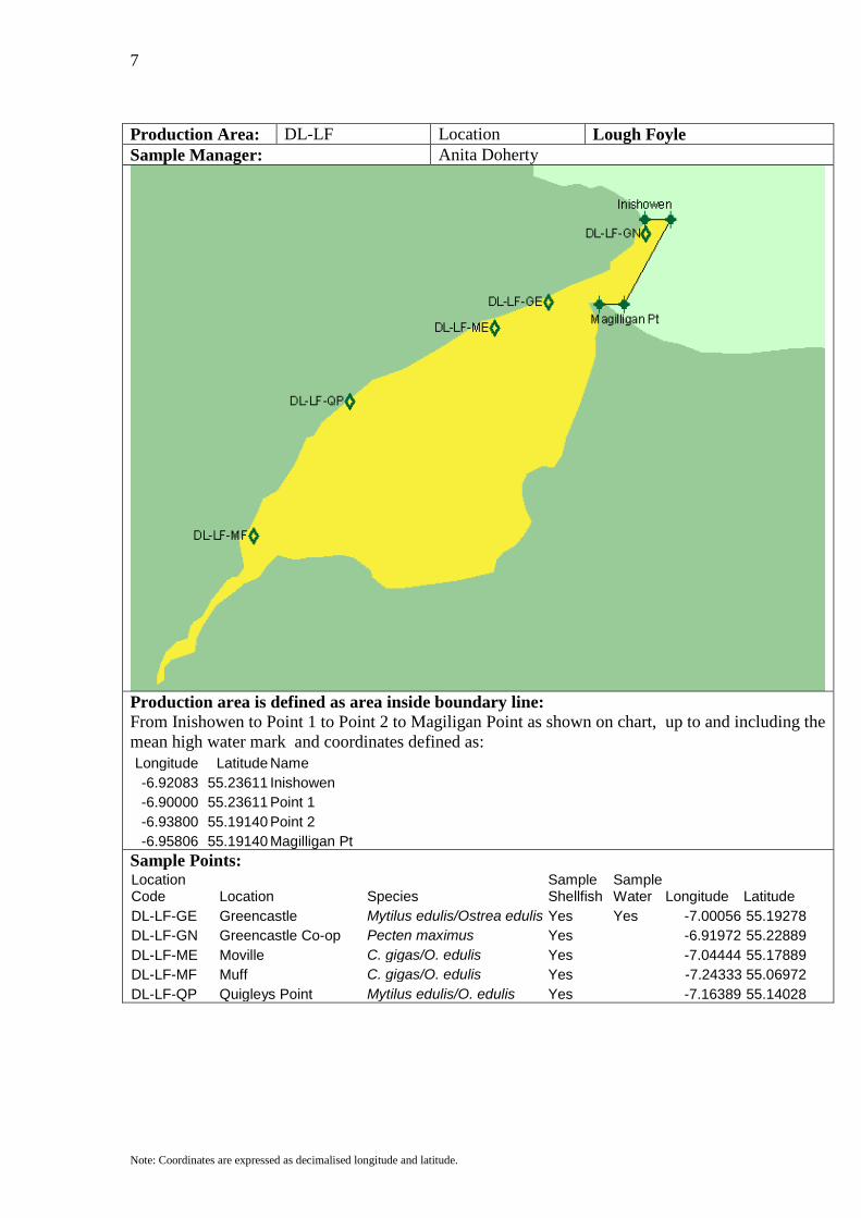
Production Area: DL-LF Location Lough Foyle Sample Manager: Anita Doherty
Production area is defined as area inside boundary line: From Inishowen to Point 1 to Point 2 to Magiligan Point as shown on chart, up to and including the mean high water mark and coordinates defined as: Longitude Latitude Name -6.92083 55.23611 Inishowen -6.90000 55.23611 Point 1 -6.93800 55.19140 Point 2 -6.95806 55.19140 Magilligan Pt
Sample Points: Location Code Location Species
Sample Shellfish
Sample Water Longitude Latitude
DL-LF-GE Greencastle Mytilus edulis/Ostrea edulis Yes Yes -7.00056 55.19278 DL-LF-GN Greencastle Co-op Pecten maximus Yes -6.91972 55.22889 DL-LF-ME Moville C. gigas/O. edulis Yes -7.04444 55.17889 DL-LF-MF Muff C. gigas/O. edulis Yes -7.24333 55.06972 DL-LF-QP Quigleys Point Mytilus edulis/O. edulis Yes -7.16389 55.14028
8
Note: Coordinates are expressed as decimalised longitude and latitude.
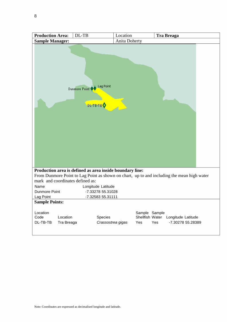
Production Area: DL-TB Location Tra Breaga Sample Manager: Anita Doherty
Production area is defined as area inside boundary line: From Dunmore Point to Lag Point as shown on chart, up to and including the mean high water mark and coordinates defined as: Name Longitude Latitude Dunmore Point -7.33278 55.31028 Lag Point -7.32583 55.31111
Sample Points:
Location Code Location Species
Sample Shellfish
Sample Water Longitude Latitude
DL-TB-TB Tra Breaga Crassostrea gigas Yes Yes -7.30278 55.28389
9
Note: Coordinates are expressed as decimalised longitude and latitude.
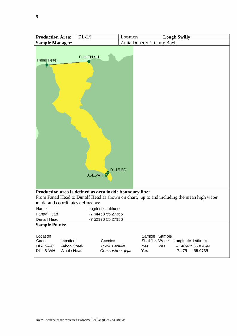
Production Area: DL-LS Location Lough Swilly Sample Manager: Anita Doherty / Jimmy Boyle
Production area is defined as area inside boundary line: From Fanad Head to Dunaff Head as shown on chart, up to and including the mean high water mark and coordinates defined as: Name Longitude Latitude Fanad Head -7.64458 55.27365 Dunaff Head -7.52370 55.27956
Sample Points:
Location Code Location Species
Sample Shellfish
Sample Water Longitude Latitude
DL-LS-FC Fahon Creek Mytilus edulis Yes Yes -7.46972 55.07694 DL-LS-WH Whale Head Crassostrea gigas Yes -7.475 55.0735
10
Note: Coordinates are expressed as decimalised longitude and latitude.
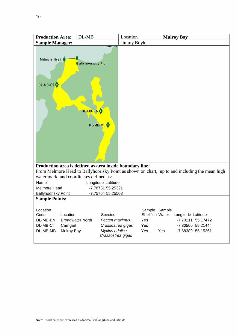
Production Area: DL-MB Location Mulroy Bay Sample Manager: Jimmy Boyle
Production area is defined as area inside boundary line: From Melmore Head to Ballyhoorisky Point as shown on chart, up to and including the mean high water mark and coordinates defined as: Name Longitude Latitude Melmore Head -7.78751 55.25321 Ballyhoorisky Point -7.75764 55.25503
Sample Points:
Location Code Location Species
Sample Shellfish
Sample Water Longitude Latitude
DL-MB-BN Broadwater North Pecten maximus Yes -7.70111 55.17472 DL-MB-CT Carrigart Crassostrea gigas Yes -7.80500 55.21444 DL-MB-MB Mulroy Bay Mytilus edulis / Yes Yes -7.68389 55.15361 Crassostrea gigas

11
Note: Coordinates are expressed as decimalised longitude and latitude.
Production Area: DL-SN Location Sheephaven Sample Manager: Jimmy Boyle
Production area is defined as area inside boundary line: From Horn Head to Rinnfaghla Point as shown on chart, up to and including the mean high water mark and coordinates defined as: Name Longitude Latitude Horn Head -7.98163 55.22686 Rinnfaghla Point -7.86715 55.22322
Sample Points:
Location Code Location Species
Sample Shellfish
Sample Water Longitude Latitude
DL-SN-SN Sheephaven Crassostrea gigas Yes Yes -7.87139 55.14778 DL-SN-DC Doe Castle Mytilus edulis Yes Yes -7.86672 55.13867
12
Note: Coordinates are expressed as decimalised longitude and latitude.
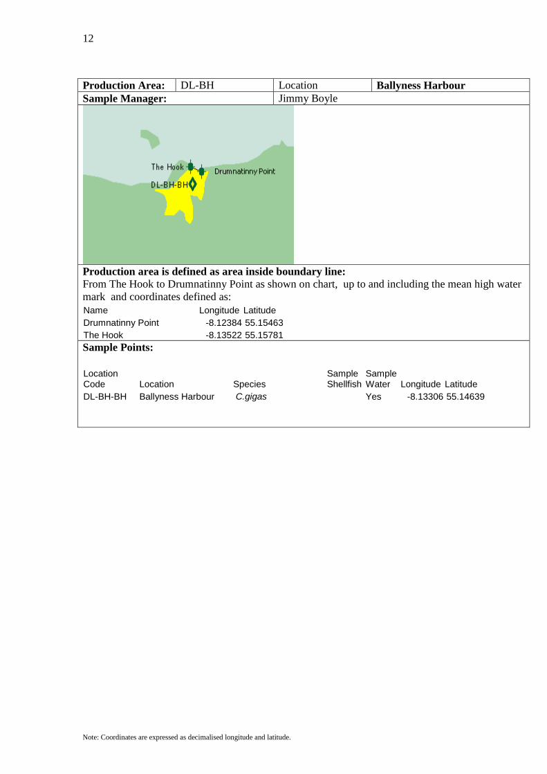
Production Area: DL-BH Location Ballyness Harbour Sample Manager: Jimmy Boyle
Production area is defined as area inside boundary line: From The Hook to Drumnatinny Point as shown on chart, up to and including the mean high water mark and coordinates defined as: Name Longitude Latitude Drumnatinny Point -8.12384 55.15463 The Hook -8.13522 55.15781
Sample Points:
Location Code Location Species
Sample Shellfish
Sample Water Longitude Latitude
DL-BH-BH Ballyness Harbour C.gigas Yes -8.13306 55.14639
13
Note: Coordinates are expressed as decimalised longitude and latitude.
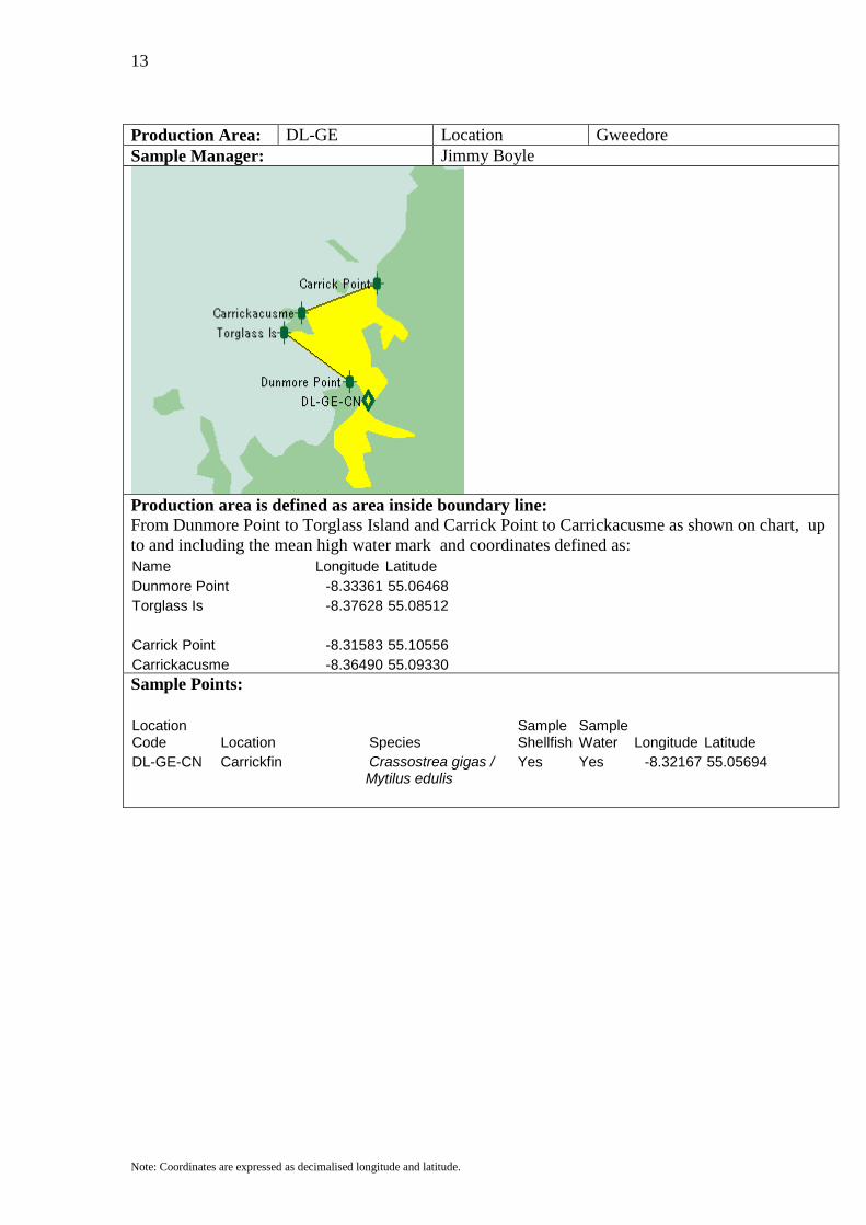
Production Area: DL-GE Location Gweedore Sample Manager: Jimmy Boyle
Production area is defined as area inside boundary line: From Dunmore Point to Torglass Island and Carrick Point to Carrickacusme as shown on chart, up to and including the mean high water mark and coordinates defined as: Name Longitude Latitude Dunmore Point -8.33361 55.06468 Torglass Is -8.37628 55.08512 Carrick Point -8.31583 55.10556 Carrickacusme -8.36490 55.09330
Sample Points:
Location Code Location Species
Sample Shellfish
Sample Water Longitude Latitude
DL-GE-CN Carrickfin Crassostrea gigas / Yes Yes -8.32167 55.05694 Mytilus edulis
14
Note: Coordinates are expressed as decimalised longitude and latitude.
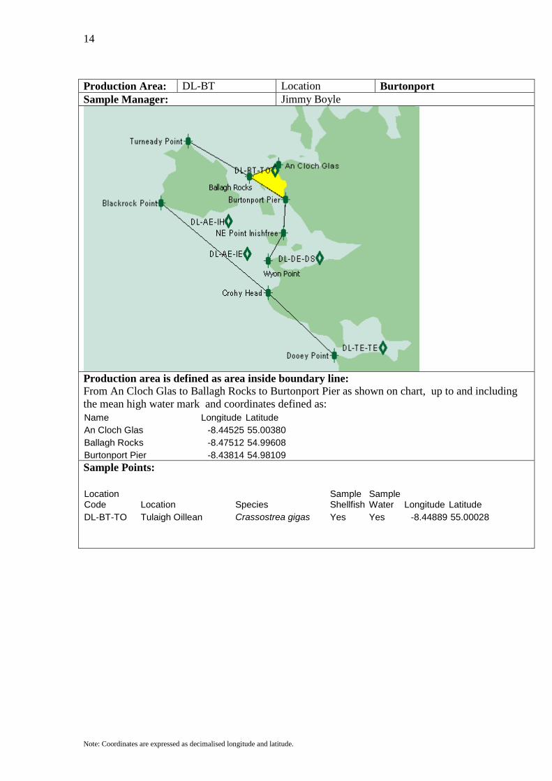
Production Area: DL-BT Location Burtonport Sample Manager: Jimmy Boyle
Production area is defined as area inside boundary line: From An Cloch Glas to Ballagh Rocks to Burtonport Pier as shown on chart, up to and including the mean high water mark and coordinates defined as: Name Longitude Latitude An Cloch Glas -8.44525 55.00380 Ballagh Rocks -8.47512 54.99608 Burtonport Pier -8.43814 54.98109
Sample Points:
Location Code Location Species
Sample Shellfish
Sample Water Longitude Latitude
DL-BT-TO Tulaigh Oillean Crassostrea gigas Yes Yes -8.44889 55.00028
15
Note: Coordinates are expressed as decimalised longitude and latitude.
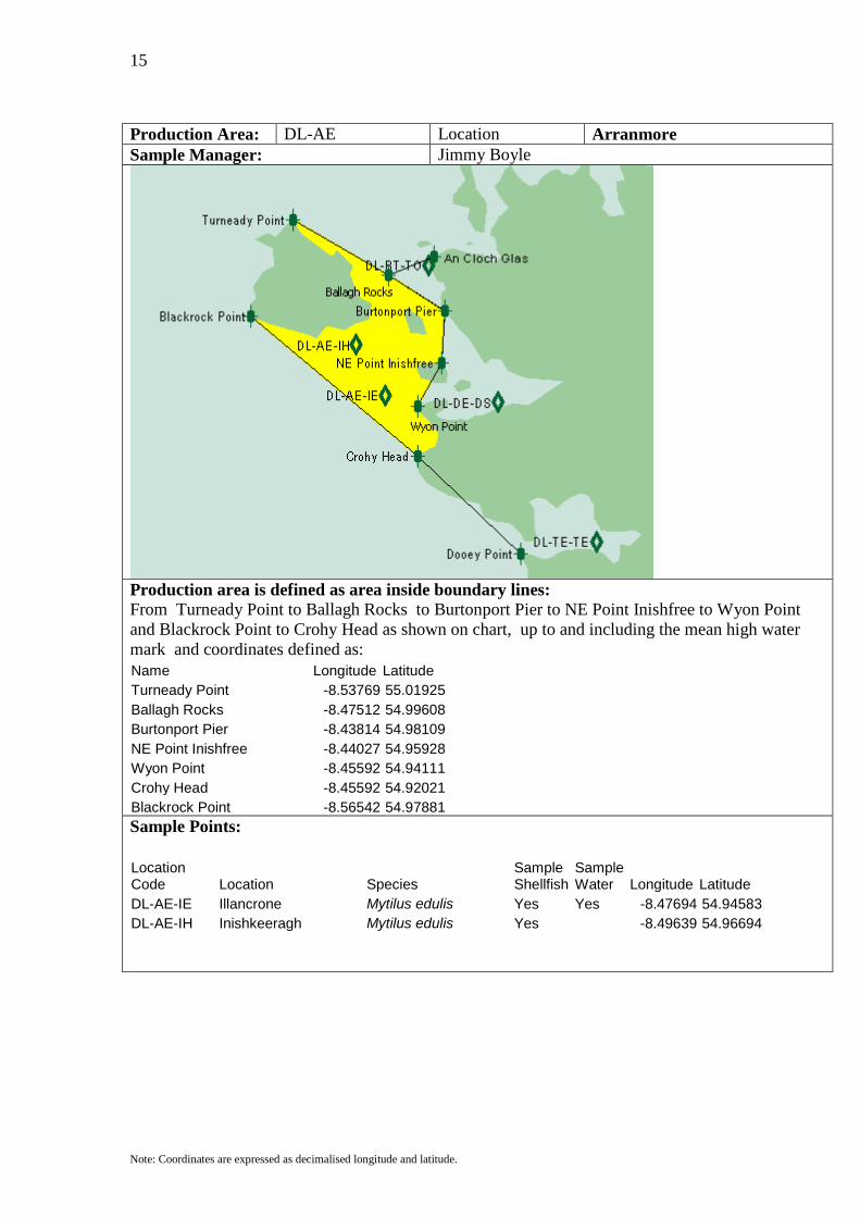
Production Area: DL-AE Location Arranmore Sample Manager: Jimmy Boyle
Production area is defined as area inside boundary lines: From Turneady Point to Ballagh Rocks to Burtonport Pier to NE Point Inishfree to Wyon Point and Blackrock Point to Crohy Head as shown on chart, up to and including the mean high water mark and coordinates defined as: Name Longitude Latitude Turneady Point -8.53769 55.01925 Ballagh Rocks -8.47512 54.99608 Burtonport Pier -8.43814 54.98109 NE Point Inishfree -8.44027 54.95928 Wyon Point -8.45592 54.94111 Crohy Head -8.45592 54.92021 Blackrock Point -8.56542 54.97881
Sample Points:
Location Code Location Species
Sample Shellfish
Sample Water Longitude Latitude
DL-AE-IE Illancrone Mytilus edulis Yes Yes -8.47694 54.94583 DL-AE-IH Inishkeeragh Mytilus edulis Yes -8.49639 54.96694
16
Note: Coordinates are expressed as decimalised longitude and latitude.
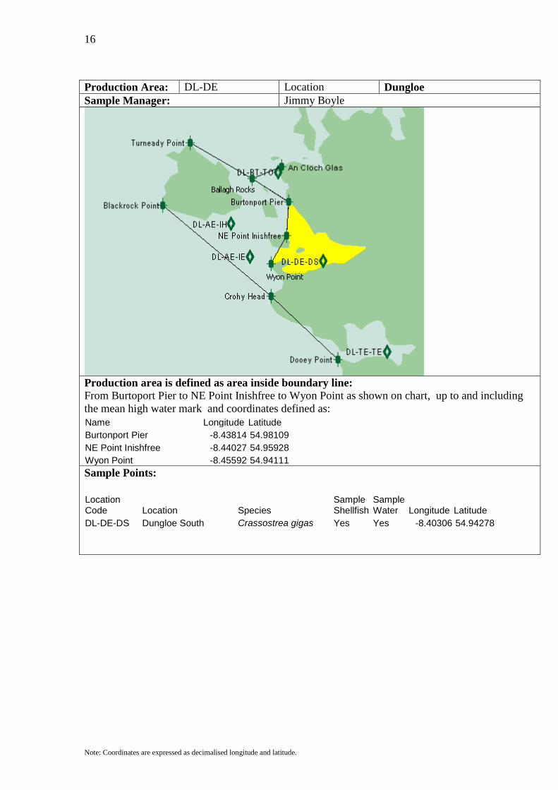
Production Area: DL-DE Location Dungloe Sample Manager: Jimmy Boyle
Production area is defined as area inside boundary line: From Burtoport Pier to NE Point Inishfree to Wyon Point as shown on chart, up to and including the mean high water mark and coordinates defined as: Name Longitude Latitude Burtonport Pier -8.43814 54.98109 NE Point Inishfree -8.44027 54.95928 Wyon Point -8.45592 54.94111
Sample Points:
Location Code Location Species
Sample Shellfish
Sample Water Longitude Latitude
DL-DE-DS Dungloe South Crassostrea gigas Yes Yes -8.40306 54.94278
17
Note: Coordinates are expressed as decimalised longitude and latitude.
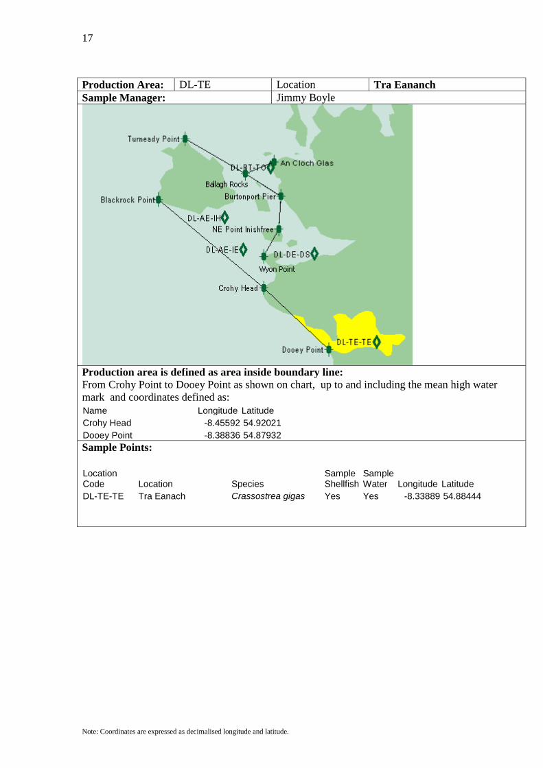
Production Area: DL-TE Location Tra Eananch Sample Manager: Jimmy Boyle
Production area is defined as area inside boundary line: From Crohy Point to Dooey Point as shown on chart, up to and including the mean high water mark and coordinates defined as: Name Longitude Latitude Crohy Head -8.45592 54.92021 Dooey Point -8.38836 54.87932
Sample Points:
Location Code Location Species
Sample Shellfish
Sample Water Longitude Latitude
DL-TE-TE Tra Eanach Crassostrea gigas Yes Yes -8.33889 54.88444
18
Note: Coordinates are expressed as decimalised longitude and latitude.
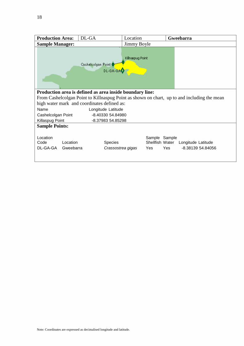
Production Area: DL-GA Location Gweebarra Sample Manager: Jimmy Boyle
Production area is defined as area inside boundary line: From Cashelcolgan Point to Killnaspug Point as shown on chart, up to and including the mean high water mark and coordinates defined as: Name Longitude Latitude Cashelcolgan Point -8.40330 54.84980 Killaspug Point -8.37983 54.85298
Sample Points:
Location Code Location Species
Sample Shellfish
Sample Water Longitude Latitude
DL-GA-GA Gweebarra Crassostrea gigas Yes Yes -8.38139 54.84056

19
Note: Coordinates are expressed as decimalised longitude and latitude.
Production Area: DL-LM Location Loughras More Sample Manager: Jimmy Boyle
Production area is defined as area inside boundary line: From Rossbeg Point to Loughras Point as shown on chart, up to and including the mean high water mark and coordinates defined as: Name Longitude Latitude Rossbeg -8.52489 54.81073 Loughras Point -8.55049 54.78619
Sample Points:
Location Code Location Species
Sample Shellfish
Sample Water Longitude Latitude
DL-LM-LM Loughras Mor Crassostrea gigas Yes Yes -8.43194 54.76889

20
Note: Coordinates are expressed as decimalised longitude and latitude.
Production Area: DL-LB Location Loughras Beag Sample Manager: Jimmy Boyle
Production area is defined as area inside boundary line: From Loughras Point to Gull Island as shown on chart, up to and including the mean high water mark and coordinates defined as: Name Longitude Latitude Loughras Point -8.55049 54.78619 Gull Island -8.60311 54.78120
Sample Points:
Location Code Location Species
Sample Shellfish
Sample Water Longitude Latitude
DL-LB-LB Loughras Beg Crassostrea gigas Yes Yes -8.47750 54.76083

21
Note: Coordinates are expressed as decimalised longitude and latitude.
Production Area: DL-TN Location Teelin Sample Manager: Paddy Gallagher
Production area is defined as area inside boundary line: From Teelin Point to Dundawoona Point as shown on chart, up to and including the mean high water mark and coordinates defined as: Name Longitude Latitude Teelin Point -8.63582 54.62129 Dundawoona Point -8.61377 54.61856
Sample Points:
Location Code Location Species
Sample Shellfish
Sample Water Longitude Latitude
DL-TN-TN Teelin Crassostrea gigas Yes Yes -8.63667 54.63806
22
Note: Coordinates are expressed as decimalised longitude and latitude.
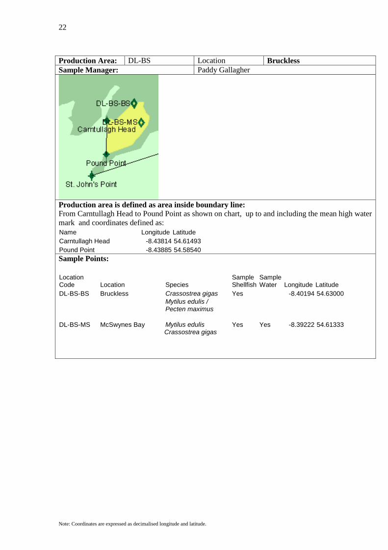
Production Area: DL-BS Location Bruckless Sample Manager: Paddy Gallagher
Production area is defined as area inside boundary line: From Carntullagh Head to Pound Point as shown on chart, up to and including the mean high water mark and coordinates defined as: Name Longitude Latitude Carntullagh Head -8.43814 54.61493 Pound Point -8.43885 54.58540
Sample Points:
Location Code Location Species
Sample Shellfish
Sample Water Longitude Latitude
DL-BS-BS Bruckless Crassostrea gigas Yes -8.40194 54.63000
Mytilus edulis / Pecten maximus
DL-BS-MS McSwynes Bay Mytilus edulis Yes Yes -8.39222 54.61333 Crassostrea gigas
23
Note: Coordinates are expressed as decimalised longitude and latitude.
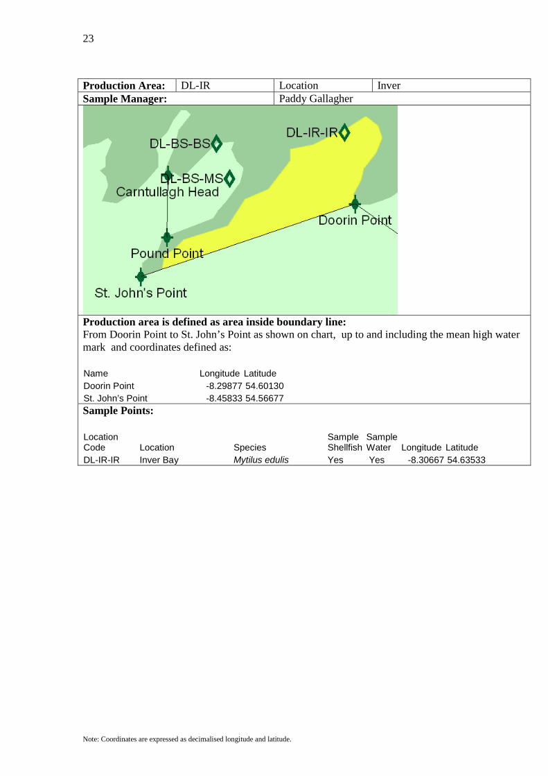
Production Area: DL-IR Location Inver Sample Manager: Paddy Gallagher
Production area is defined as area inside boundary line: From Doorin Point to St. John’s Point as shown on chart, up to and including the mean high water mark and coordinates defined as: Name Longitude Latitude Doorin Point -8.29877 54.60130 St. John’s Point -8.45833 54.56677
Sample Points:
Location Code Location Species
Sample Shellfish
Sample Water Longitude Latitude
DL-IR-IR Inver Bay Mytilus edulis Yes Yes -8.30667 54.63533

24
Note: Coordinates are expressed as decimalised longitude and latitude.
Production Area: DL-DH Location Donegal Harbour Sample Manager: Paddy Gallagher
Production area is defined as area inside boundary line: From Doorin Point to Rossnowlagh Point as shown on chart, up to and including the mean high water mark and coordinates defined as: Name Longitude Latitude Doorin Point -8.29877 54.60130 Rossnowlagh Point -8.22126 54.56677
Sample Points:
Location Code Location Species
Sample Shellfish
Sample Water Longitude Latitude
DL-DH-DH Donegal Harbour Pecten maximus Yes -8.19917 54.62194 DL-DH-LC Laghy Channel Crassostrea gigas Yes -8.13583 54.62083 DL-DH-MS Mountcharles Crassostrea gigas / Yes Yes -8.17528 54.63222 Mytilus edulis
25
Note: Coordinates are expressed as decimalised longitude and latitude.
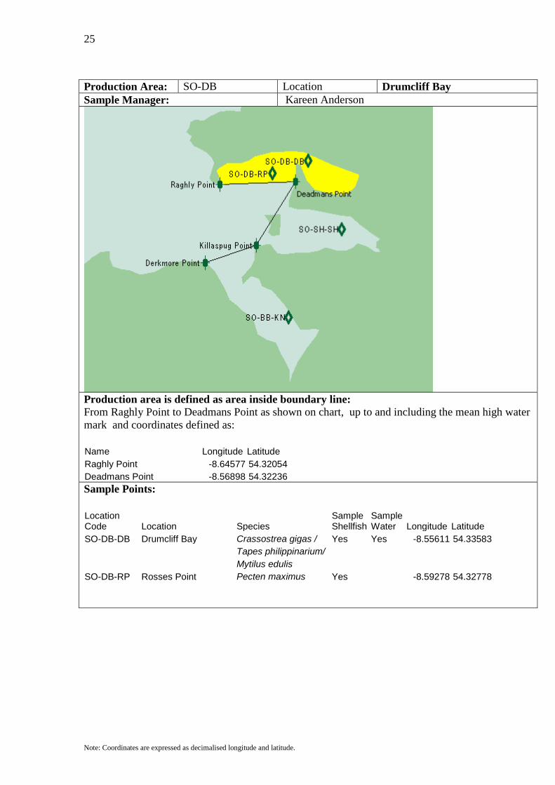
Production Area: SO-DB Location Drumcliff Bay Sample Manager: Kareen Anderson
Production area is defined as area inside boundary line: From Raghly Point to Deadmans Point as shown on chart, up to and including the mean high water mark and coordinates defined as: Name Longitude Latitude Raghly Point -8.64577 54.32054 Deadmans Point -8.56898 54.32236
Sample Points:
Location Code Location Species
Sample Shellfish
Sample Water Longitude Latitude
SO-DB-DB Drumcliff Bay Crassostrea gigas / Yes Yes -8.55611 54.33583 Tapes philippinarium/ Mytilus edulis SO-DB-RP Rosses Point Pecten maximus Yes -8.59278 54.32778
26
Note: Coordinates are expressed as decimalised longitude and latitude.
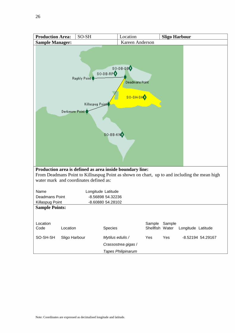
Production Area: SO-SH Location Sligo Harbour Sample Manager: Kareen Anderson
Production area is defined as area inside boundary line: From Deadmans Point to Killnaspug Point as shown on chart, up to and including the mean high water mark and coordinates defined as: Name Longitude Latitude Deadmans Point -8.56898 54.32236 Killaspug Point -8.60880 54.28102
Sample Points:
Location Code Location Species
Sample Shellfish
Sample Water Longitude Latitude
SO-SH-SH Sligo Harbour Mytilus edulis / Yes Yes -8.52194 54.29167
Crassostrea gigas /
Tapes Philipinarum
27
Note: Coordinates are expressed as decimalised longitude and latitude.
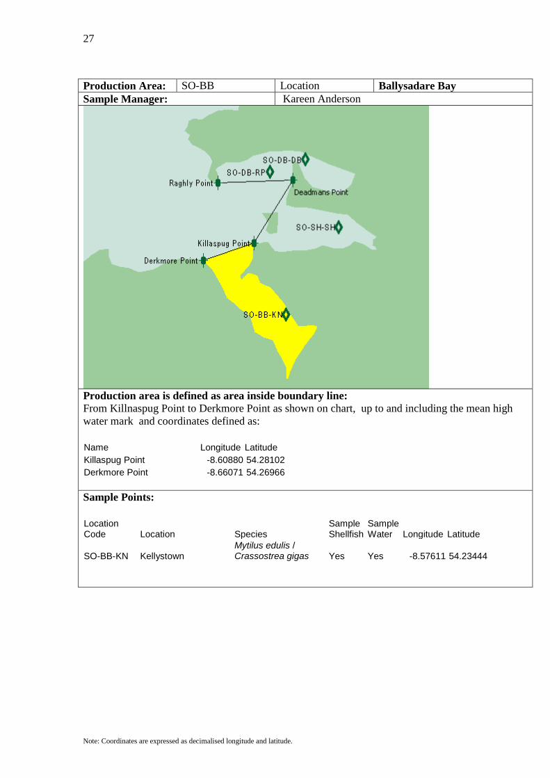
Production Area: SO-BB Location Ballysadare Bay Sample Manager: Kareen Anderson
Production area is defined as area inside boundary line: From Killnaspug Point to Derkmore Point as shown on chart, up to and including the mean high water mark and coordinates defined as: Name Longitude Latitude Killaspug Point -8.60880 54.28102 Derkmore Point -8.66071 54.26966
Sample Points:
Location Code Location Species
Sample Shellfish
Sample Water Longitude Latitude
SO-BB-KN Kellystown Mytilus edulis / Crassostrea gigas Yes Yes -8.57611 54.23444
28
Note: Coordinates are expressed as decimalised longitude and latitude.
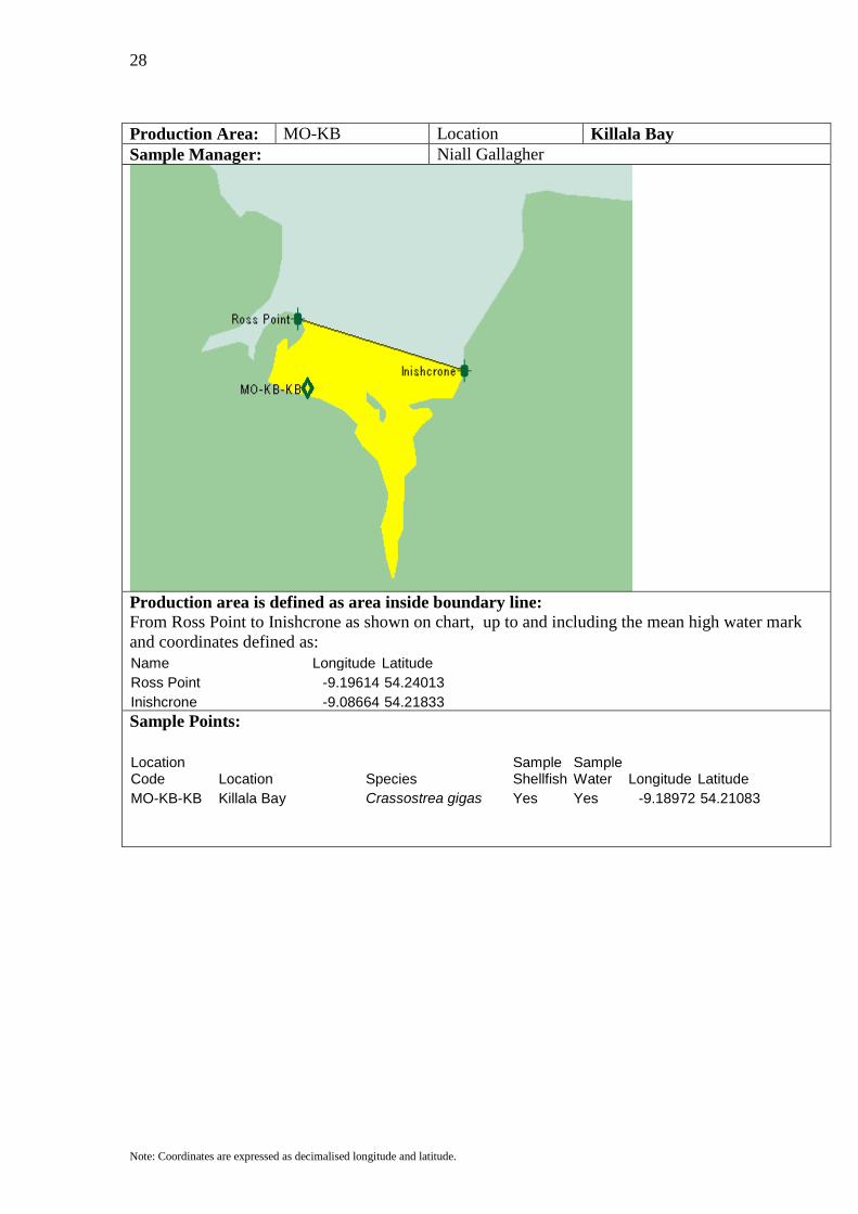
Production Area: MO-KB Location Killala Bay Sample Manager: Niall Gallagher
Production area is defined as area inside boundary line: From Ross Point to Inishcrone as shown on chart, up to and including the mean high water mark and coordinates defined as: Name Longitude Latitude Ross Point -9.19614 54.24013 Inishcrone -9.08664 54.21833
Sample Points:
Location Code Location Species
Sample Shellfish
Sample Water Longitude Latitude
MO-KB-KB Killala Bay Crassostrea gigas Yes Yes -9.18972 54.21083
29
Note: Coordinates are expressed as decimalised longitude and latitude.
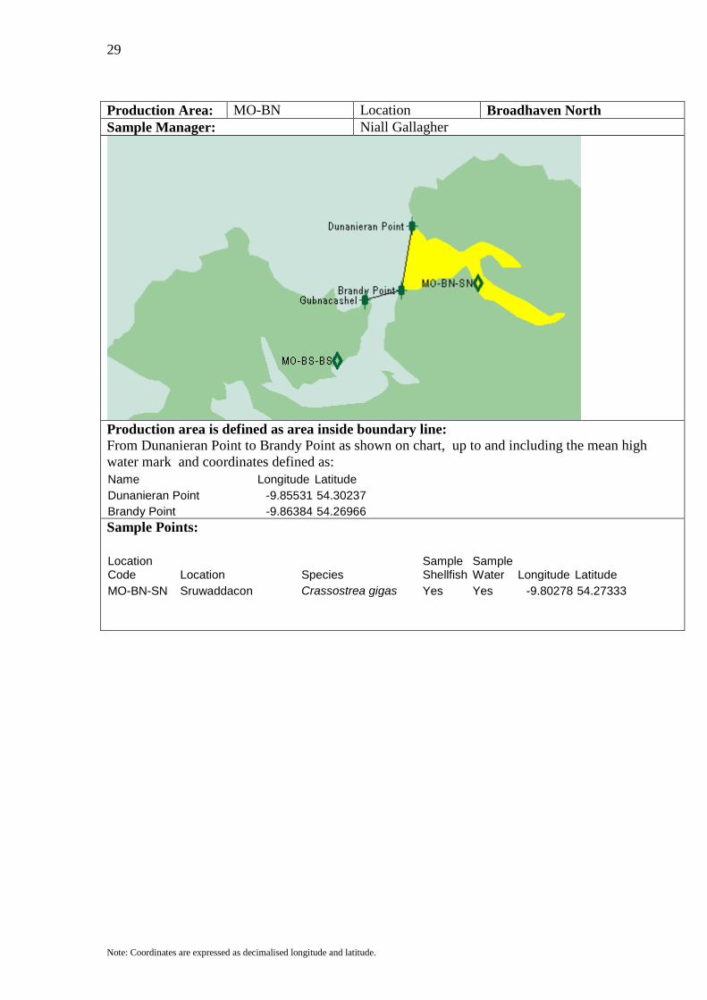
Production Area: MO-BN Location Broadhaven North Sample Manager: Niall Gallagher
Production area is defined as area inside boundary line: From Dunanieran Point to Brandy Point as shown on chart, up to and including the mean high water mark and coordinates defined as: Name Longitude Latitude Dunanieran Point -9.85531 54.30237 Brandy Point -9.86384 54.26966
Sample Points:
Location Code Location Species
Sample Shellfish
Sample Water Longitude Latitude
MO-BN-SN Sruwaddacon Crassostrea gigas Yes Yes -9.80278 54.27333
30
Note: Coordinates are expressed as decimalised longitude and latitude.
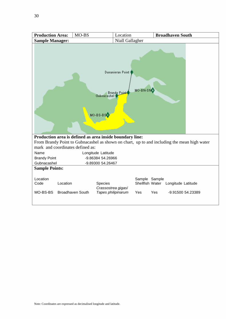
Production Area: MO-BS Location Broadhaven South Sample Manager: Niall Gallagher
Production area is defined as area inside boundary line: From Brandy Point to Gubnacashel as shown on chart, up to and including the mean high water mark and coordinates defined as: Name Longitude Latitude Brandy Point -9.86384 54.26966 Gubnacashel -9.89300 54.26467
Sample Points:
Location Code Location Species
Sample Shellfish
Sample Water Longitude Latitude
MO-BS-BS Broadhaven South Crassostrea gigas/ Tapes philipinarum Yes Yes -9.91500 54.23389
31
Note: Coordinates are expressed as decimalised longitude and latitude.
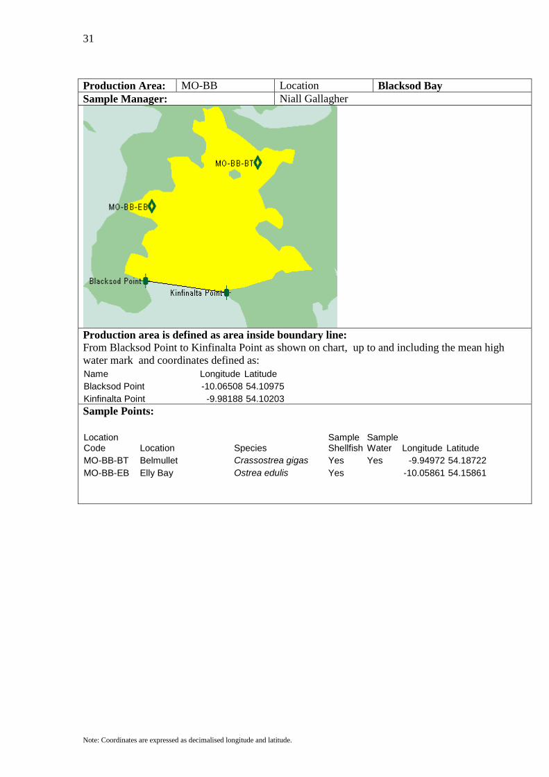
Production Area: MO-BB Location Blacksod Bay Sample Manager: Niall Gallagher
Production area is defined as area inside boundary line: From Blacksod Point to Kinfinalta Point as shown on chart, up to and including the mean high water mark and coordinates defined as: Name Longitude Latitude Blacksod Point -10.06508 54.10975 Kinfinalta Point -9.98188 54.10203
Sample Points:
Location Code Location Species
Sample Shellfish
Sample Water Longitude Latitude
MO-BB-BT Belmullet Crassostrea gigas Yes Yes -9.94972 54.18722 MO-BB-EB Elly Bay Ostrea edulis Yes -10.05861 54.15861

32
Note: Coordinates are expressed as decimalised longitude and latitude.
Production Area: MO-AN Location Achill North Sample Manager: John Falvey
Production area is defined as area inside boundary lines: From Kinrover Point to Ridge Point and Achill Bridge East to Achill Bridge West as shown on chart, up to and including the mean high water mark and coordinates defined as: Name Longitude Latitude Kinrover Point -9.96553 54.06114 Ridge Point -9.97406 54.02980 Achill Bridge E -9.91220 53.93439 Achill Bridge W -9.92428 53.93031
Sample Points:
Location Code Location Species
Sample Shellfish
Sample Water Longitude Latitude
MO-AN-AN Achill North Ostrea edulis Yes -9.88722 53.96639 MO-AN-BR Bealacragher Mytilus edulis Yes -9.80139 53.92361 MO-AN-BY Bunacurry Crassostrea gigas Yes Yes -9.94500 53.97417 Littorina littorea MO-AN-DC Dooriel Creek Crassostrea gigas / Yes -9.87889 54.00194 Ostrea edulis

33
Note: Coordinates are expressed as decimalised longitude and latitude.
Production Area: MO-AS Location Achill South Sample Manager: John Falvey
Production area is defined as area inside boundary line: From Achill Bridge East to Achill Bridge West and Bollinglanna to Southernmost Pt Achillbeg as shown on chart, up to and including the mean high water mark and coordinates defined as: Name Longitude Latitude Achill Bridge E -9.91220 53.93439 Achill Bridge W -9.92428 53.93031 Bollinglanna -9.90153 53.86352 Southernmost Pt Achillbeg -9.94917 53.85944
Sample Points:
Location Code Location Species
Sample Shellfish
Sample Water Longitude Latitude
MO-AS-CN Corraun Crassostrea gigas Yes Yes -9.93722 53.87972 Littorina littorea

34
Note: Coordinates are expressed as decimalised longitude and latitude.
Production Area: MO-CN Location Clew Bay North Sample Manager: John Falvey
Production area is defined as area inside boundary line: From Mulranny Point due south to a point due west of Cooshalogort and then east to Cooshalogort as shown on chart, up to and including the mean high water mark and coordinates defined as: Name Longitude Latitude Mulranny -9.74296 53.89351 Point west of Cooshalogort -9.74296 53.84944 Cooshalogort -9.56732 53.84944
Sample Points:
Location Code Location Species
Sample Shellfish
Sample Water Longitude Latitude
MO-CN-CN Clew Bay North Pecten maximus Yes -9.66944 53.85500 MO-CN-DH Derrinish Ostrea edulis Yes -9.64111 53.85028 MO-CN-IK Inisquirk Crassostrea gigas Yes -9.67750 53.88556 MO-CN-IL Inishlaughill Mytilus edulis Yes Yes -9.63500 53.86444
35
Note: Coordinates are expressed as decimalised longitude and latitude.
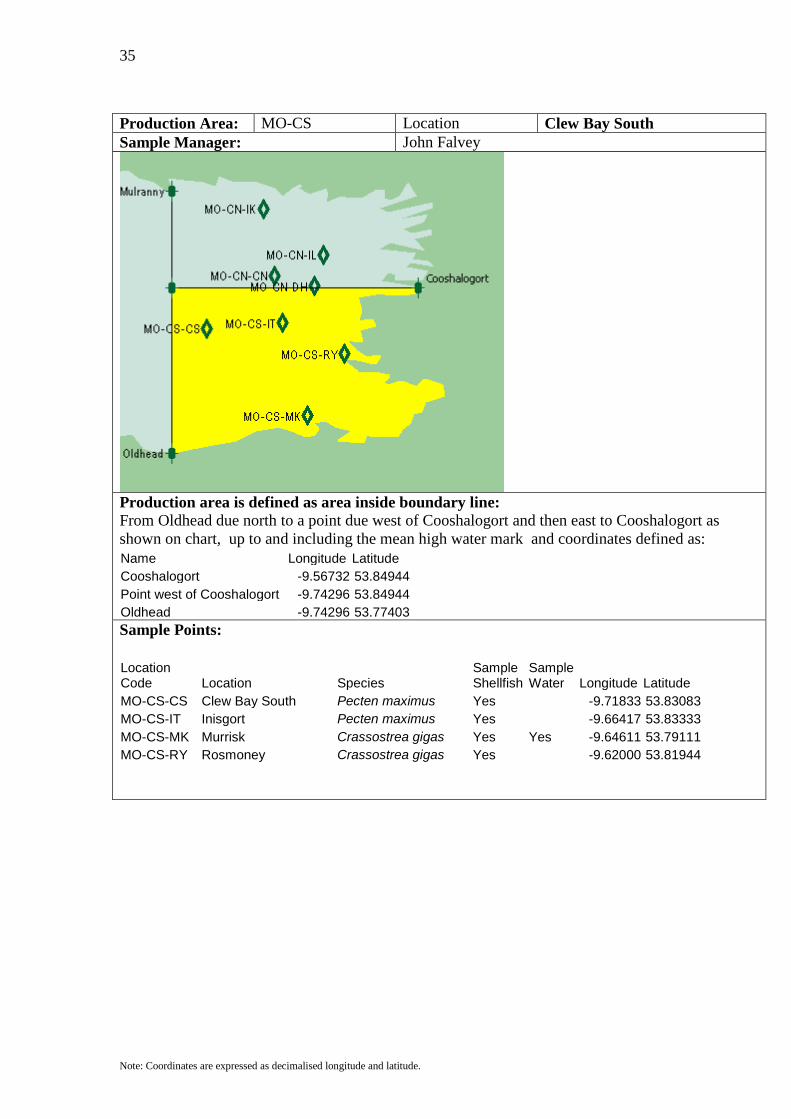
Production Area: MO-CS Location Clew Bay South Sample Manager: John Falvey
Production area is defined as area inside boundary line: From Oldhead due north to a point due west of Cooshalogort and then east to Cooshalogort as shown on chart, up to and including the mean high water mark and coordinates defined as: Name Longitude Latitude Cooshalogort -9.56732 53.84944 Point west of Cooshalogort -9.74296 53.84944 Oldhead -9.74296 53.77403
Sample Points:
Location Code Location Species
Sample Shellfish
Sample Water Longitude Latitude
MO-CS-CS Clew Bay South Pecten maximus Yes -9.71833 53.83083 MO-CS-IT Inisgort Pecten maximus Yes -9.66417 53.83333 MO-CS-MK Murrisk Crassostrea gigas Yes Yes -9.64611 53.79111 MO-CS-RY Rosmoney Crassostrea gigas Yes -9.62000 53.81944

36
Note: Coordinates are expressed as decimalised longitude and latitude.
Production Area: GY-KI Location Killary Harbour Inner Sample Manager: Stiofan De Burca
Production area is defined as area inside boundary line: From points at the bend in Killary Harbour as shown on chart, east, up to and including the mean high water mark and coordinates defined as: Name Longitude Latitude Bend North -9.79273 53.60776 Bend South -9.79558 53.60003
Sample Points:
Location Code Location Species
Sample Shellfish
Sample Water Longitude Latitude
GY-KI-KI Killary Harbour Inner Mytilus edulis Yes -9.75528 53.60000

37
Note: Coordinates are expressed as decimalised longitude and latitude.
Production Area: GY-KM Location Killary Harbour Mid Sample Manager: Stiofan De Burca
Production area is defined as area inside boundary line: From points at the bend in Killary Harbour to a line defined by points further west as shown on chart, up to and including the mean high water mark and coordinates defined as: Name Longitude Latitude Bend North -9.79273 53.60776 Bend South -9.79558 53.60003 Killary North -9.81407 53.61503 Killary South -9.81691 53.60867
Sample Points:
Location Code Location Species
Sample Shellfish
Sample Water Longitude Latitude
GY-KM-KM Killary Harbour Middle Mytilus edulis Yes -9.80278 53.60389
38
Note: Coordinates are expressed as decimalised longitude and latitude.
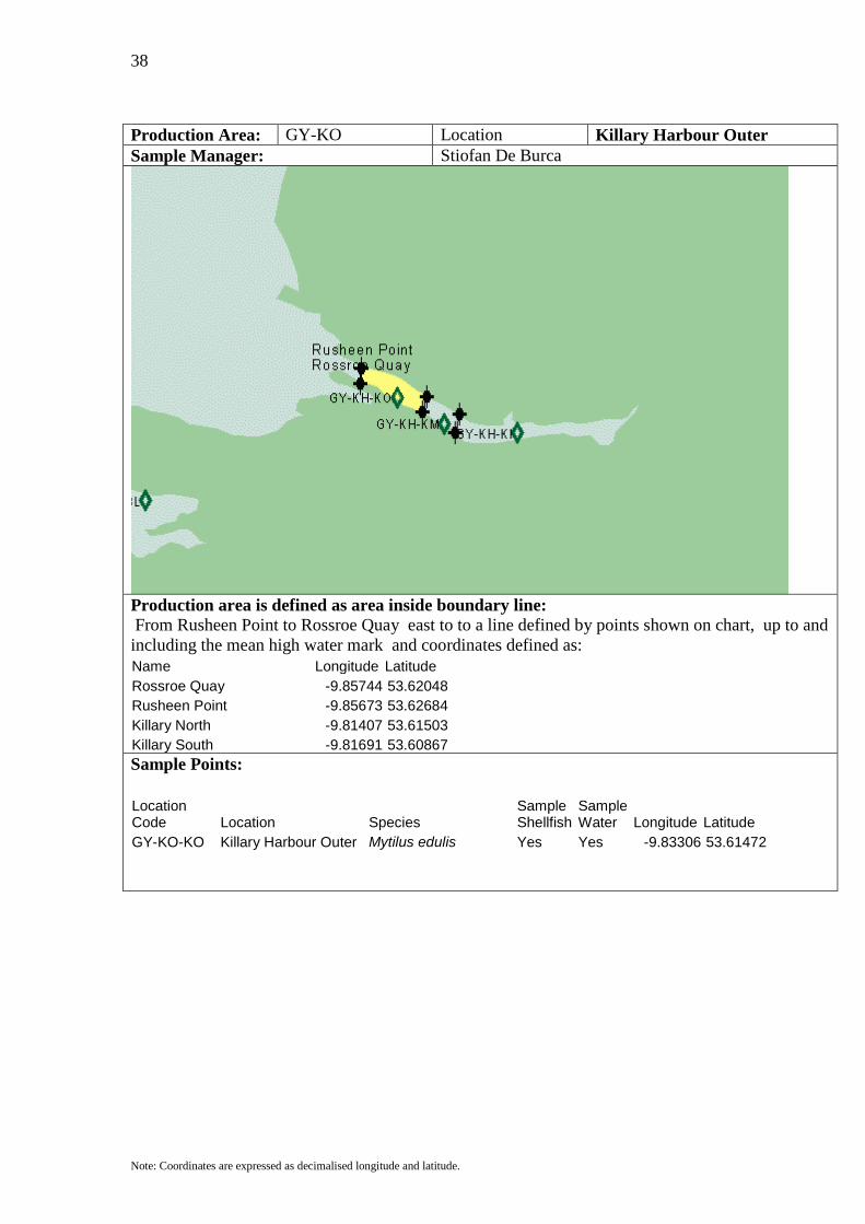
Production Area: GY-KO Location Killary Harbour Outer Sample Manager: Stiofan De Burca
Production area is defined as area inside boundary line: From Rusheen Point to Rossroe Quay east to to a line defined by points shown on chart, up to and including the mean high water mark and coordinates defined as: Name Longitude Latitude Rossroe Quay -9.85744 53.62048 Rusheen Point -9.85673 53.62684 Killary North -9.81407 53.61503 Killary South -9.81691 53.60867
Sample Points:
Location Code Location Species
Sample Shellfish
Sample Water Longitude Latitude
GY-KO-KO Killary Harbour Outer Mytilus edulis Yes Yes -9.83306 53.61472
39
Note: Coordinates are expressed as decimalised longitude and latitude.
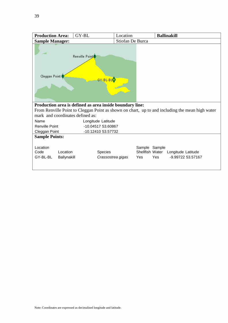
Production Area: GY-BL Location Ballinakill Sample Manager: Stiofan De Burca
Production area is defined as area inside boundary line: From Renville Point to Cleggan Point as shown on chart, up to and including the mean high water mark and coordinates defined as: Name Longitude Latitude Renville Point -10.04517 53.60867 Cleggan Point -10.12410 53.57732
Sample Points:
Location Code Location Species
Sample Shellfish
Sample Water Longitude Latitude
GY-BL-BL Ballynakill Crassostrea gigas Yes Yes -9.99722 53.57167
40
Note: Coordinates are expressed as decimalised longitude and latitude.
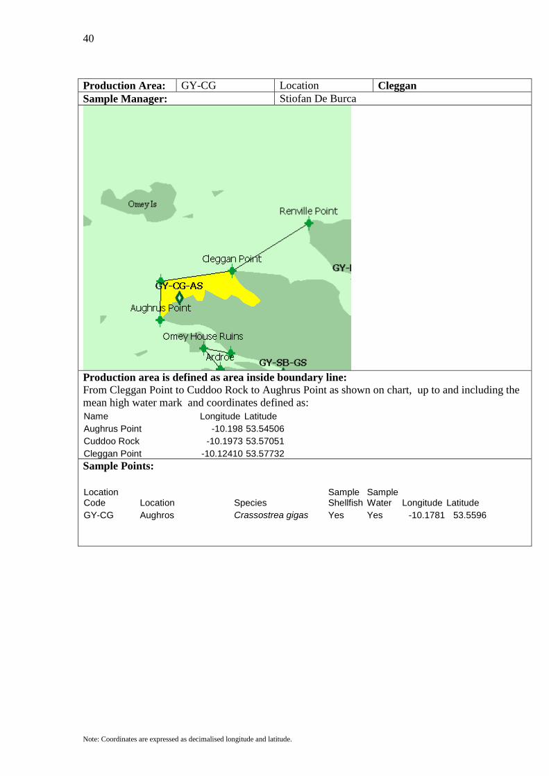
Production Area: GY-CG Location Cleggan Sample Manager: Stiofan De Burca
Production area is defined as area inside boundary line: From Cleggan Point to Cuddoo Rock to Aughrus Point as shown on chart, up to and including the mean high water mark and coordinates defined as: Name Longitude Latitude Aughrus Point -10.198 53.54506 Cuddoo Rock -10.1973 53.57051 Cleggan Point -10.12410 53.57732
Sample Points:
Location Code Location Species
Sample Shellfish
Sample Water Longitude Latitude
GY-CG Aughros Crassostrea gigas Yes Yes -10.1781 53.5596
41
Note: Coordinates are expressed as decimalised longitude and latitude.
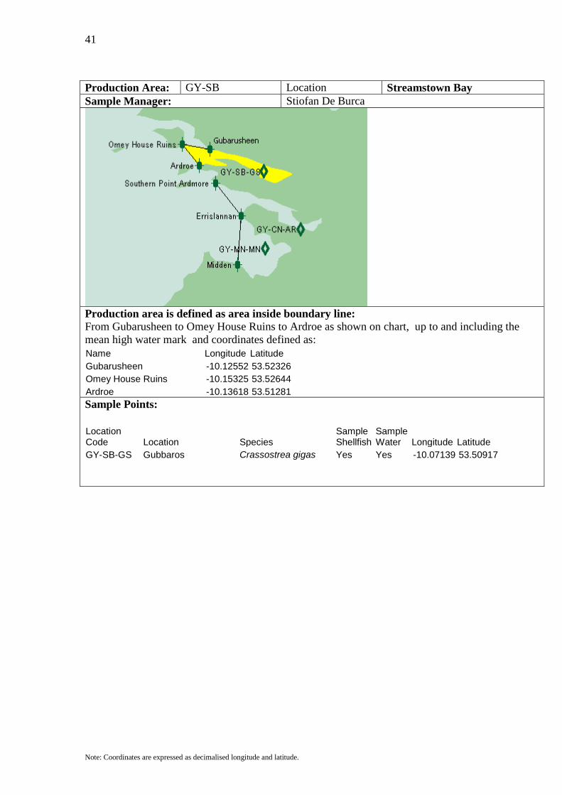
Production Area: GY-SB Location Streamstown Bay Sample Manager: Stiofan De Burca
Production area is defined as area inside boundary line: From Gubarusheen to Omey House Ruins to Ardroe as shown on chart, up to and including the mean high water mark and coordinates defined as: Name Longitude Latitude Gubarusheen -10.12552 53.52326 Omey House Ruins -10.15325 53.52644 Ardroe -10.13618 53.51281
Sample Points:
Location Code Location Species
Sample Shellfish
Sample Water Longitude Latitude
GY-SB-GS Gubbaros Crassostrea gigas Yes Yes -10.07139 53.50917

42
Note: Coordinates are expressed as decimalised longitude and latitude.
Production Area: GY-CN Location Clifden Sample Manager: Stiofan De Burca
Production area is defined as area inside boundary line: From Turbot Island West to Errislannan, and from Turbot Island East to Southern Point Ardmore as shown on chart, up to and including the mean high water mark and coordinates defined as: Name Longitude Latitude Turbot Island West -10.16009 53.49843 Turbot Island East -10.14096 53.50018 Southern Point Ardmore -10.11983 53.50145 Errislannan -10.09423 53.48055
Sample Points:
Location Code Location Species
Sample Shellfish
Sample Water Longitude Latitude
GY-CN-AR Ardbear Mytilus edulis / Yes Yes -10.03472 53.47194
Spisula solida / Dosina exoleta / Ensis arcuatus / Crassostrea gigas / Glycymeris glycymeris
GY-CN-CO Cliffden Outer Spisula solida / Yes Yes -10.03472 53.47194
Ensis arcuatus
43
Note: Coordinates are expressed as decimalised longitude and latitude.
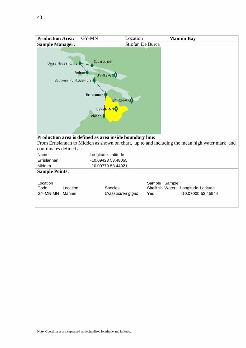
Production Area: GY-MN Location Mannin Bay Sample Manager: Stiofan De Burca
Production area is defined as area inside boundary line: From Errislannan to Midden as shown on chart, up to and including the mean high water mark and coordinates defined as: Name Longitude Latitude Errislannan -10.09423 53.48055 Midden -10.09779 53.44921
Sample Points:
Location Code Location Species
Sample Shellfish
Sample Water Longitude Latitude
GY-MN-MN Mannin Crassostrea gigas Yes -10.07000 53.45944
44
Note: Coordinates are expressed as decimalised longitude and latitude.
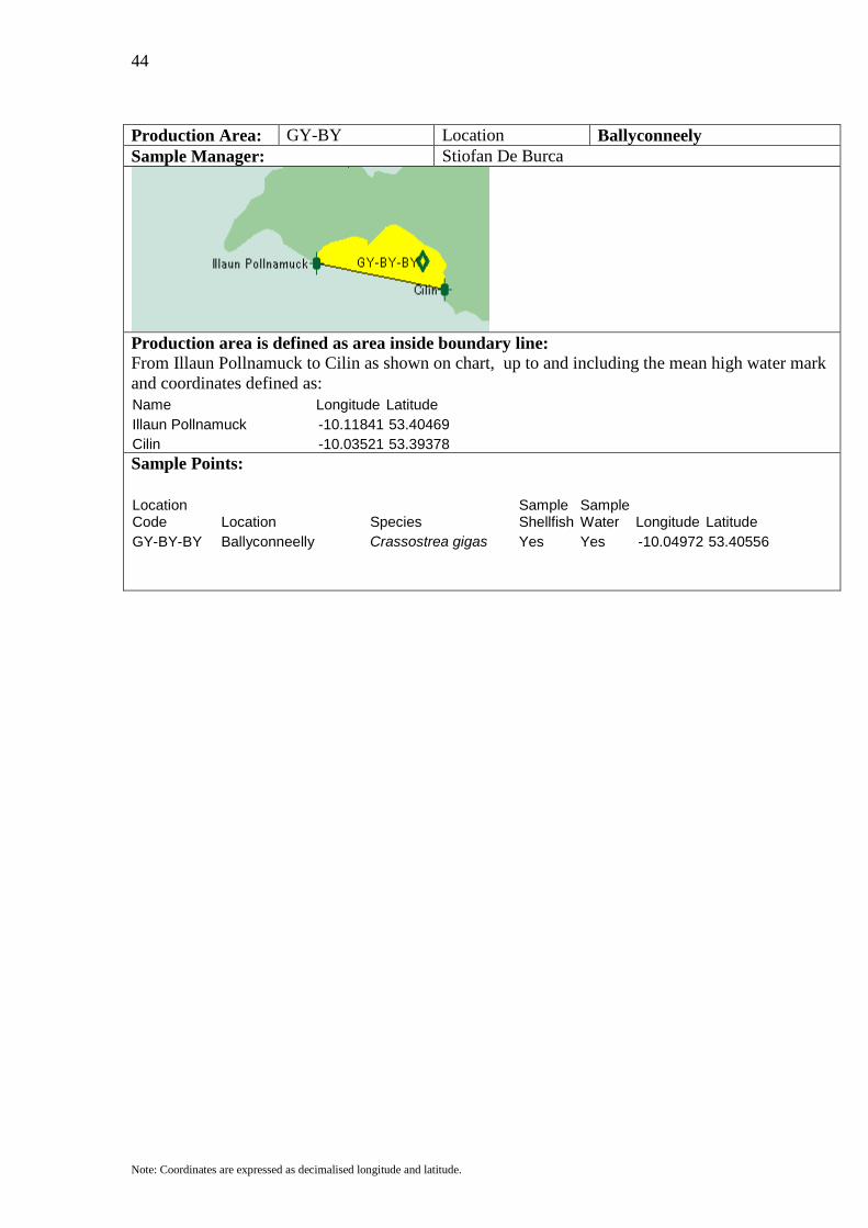
Production Area: GY-BY Location Ballyconneely Sample Manager: Stiofan De Burca
Production area is defined as area inside boundary line: From Illaun Pollnamuck to Cilin as shown on chart, up to and including the mean high water mark and coordinates defined as: Name Longitude Latitude Illaun Pollnamuck -10.11841 53.40469 Cilin -10.03521 53.39378
Sample Points:
Location Code Location Species
Sample Shellfish
Sample Water Longitude Latitude
GY-BY-BY Ballyconneelly Crassostrea gigas Yes Yes -10.04972 53.40556

45
Note: Coordinates are expressed as decimalised longitude and latitude.
Production Area: GY-BB Location Bertraghboy Sample Manager: Stiofan De Burca
Production area is defined as area inside boundary line: From as shown on chart, up to and including the mean high water mark and coordinates defined as: Name Longitude Latitude Ervallagh -9.92713 53.38152 Letterard -9.88731 53.35971
Sample Points:
Location Code Location Species
Sample Shellfish
Sample Water Longitude Latitude
GY-BB-BB Bertraghaboy Bay Pecten maximus Yes -9.87306 53.37806 GY-BB-IM Illaungorm Ostrea edulis Oyster Yes Yes -9.85556 53.38111 GY-BB-LD Letterard Crassostrea gigas Yes -9.89111 53.36861 GY-BB-RE Roundstone Crassostrea gigas Yes -9.91667 53.39833

46
Note: Coordinates are expressed as decimalised longitude and latitude.
Production Area: GY-KN Location Kilkieran North Sample Manager: Stiofan De Burca
Production area is defined as area inside boundary line: From Ardmore Point to Lettermore as shown on chart, up to and including the mean high water mark and coordinates defined as: Name Longitude Latitude Ardmore Point -9.77140 53.29384 Lettermore -9.70456 53.29747
Sample Points:
Location Code Location Species
Sample Shellfish
Sample Water Longitude Latitude
GY-KN-KP Kilkieran Point Pecten maximus Yes -9.73194 53.30556 Ensis siliqua GY-KN-RC Rosmuc Ostrea edulis Yes Yes -9.59861 53.33194

47
Note: Coordinates are expressed as decimalised longitude and latitude.
Production Area: GY-KS Location Kilkieran South Sample Manager: Stiofan De Burca
Production area is defined as area inside boundary line: From Ardmore Point to Lettermore and from Mulroa Point to Golam to Cloghmore Pointas shown on chart, up to and including the mean high water mark and coordinates defined as: Name Longitude Latitude Ardmore Point -9.77140 53.29384 Lettermore -9.70456 53.29747 Mulroa Pt -9.83469 53.29248 Golam -9.74367 53.23206 Cloghmore Point -9.52039 53.22660
Sample Points:
Location Code Location Species
Sample Shellfish
Sample Water Longitude Latitude
GY-KS-IH Illauneragh Pecten maximus / Yes -9.74806 53.27833 Mytilus edulis GY-KS-CA Cashla Crassostrea gigas / Yes Yes -9.55083 53.24698 Haliotis discus hannai

48
Note: Coordinates are expressed as decimalised longitude and latitude.
Production Area: GY-GN Location Galway Bay North Sample Manager: Paul Connery
Production area is defined as area inside boundary line: From Ardmore Point to Lettermore and from Mulroa Point to Golam to Cloghmore Pointas shown on chart, up to and including the mean high water mark and coordinates defined as: Name Longitude Latitude Cloghmore Point -9.52039 53.22660 Golam -9.74367 53.23206 Inishmore North -9.81335 53.14892 Kilronan -9.6718 53.11712 Kilcolgan Point -9.0432 53.2188 Roscam -8.9835 53.2624
Sample Points:
Location Code Location Species
Sample Shellfish
Sample Water Longitude Latitude
GY-GN-IN Inverin Mytilus edulis Yes 9.43 53.21
49
Note: Coordinates are expressed as decimalised longitude and latitude.
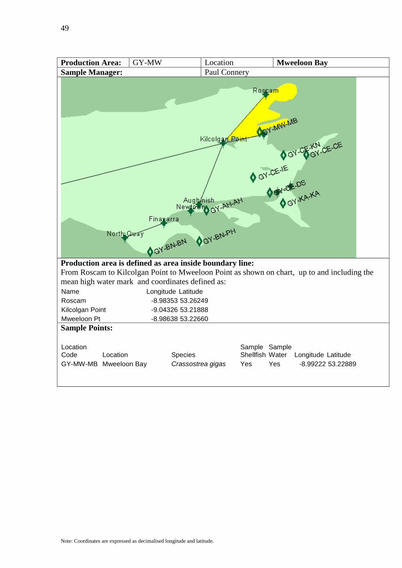
Production Area: GY-MW Location Mweeloon Bay Sample Manager: Paul Connery
Production area is defined as area inside boundary line: From Roscam to Kilcolgan Point to Mweeloon Point as shown on chart, up to and including the mean high water mark and coordinates defined as: Name Longitude Latitude Roscam -8.98353 53.26249 Kilcolgan Point -9.04326 53.21888 Mweeloon Pt -8.98638 53.22660
Sample Points:
Location Code Location Species
Sample Shellfish
Sample Water Longitude Latitude
GY-MW-MB Mweeloon Bay Crassostrea gigas Yes Yes -8.99222 53.22889
50
Note: Coordinates are expressed as decimalised longitude and latitude.
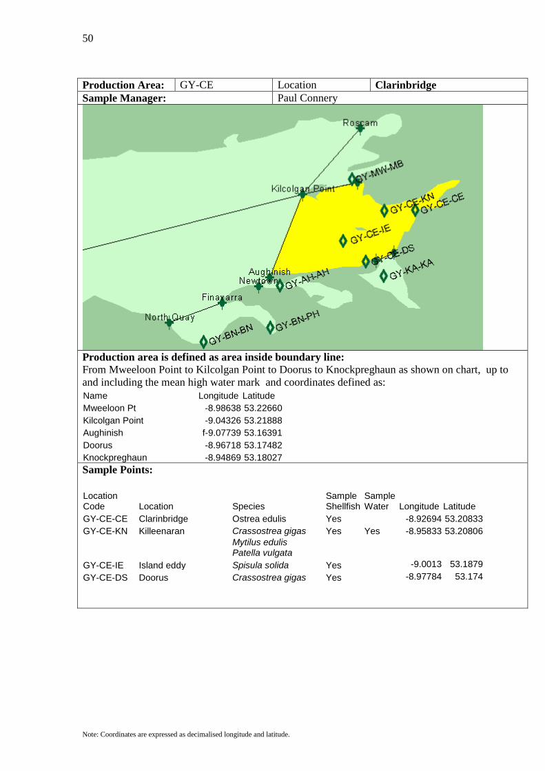
Production Area: GY-CE Location Clarinbridge Sample Manager: Paul Connery
Production area is defined as area inside boundary line: From Mweeloon Point to Kilcolgan Point to Doorus to Knockpreghaun as shown on chart, up to and including the mean high water mark and coordinates defined as: Name Longitude Latitude Mweeloon Pt -8.98638 53.22660 Kilcolgan Point -9.04326 53.21888 Aughinish f-9.07739 53.16391 Doorus -8.96718 53.17482 Knockpreghaun -8.94869 53.18027
Sample Points:
Location Code Location Species
Sample Shellfish
Sample Water Longitude Latitude
GY-CE-CE Clarinbridge Ostrea edulis Yes -8.92694 53.20833 GY-CE-KN Killeenaran Crassostrea gigas Yes Yes -8.95833 53.20806
Mytilus edulis Patella vulgata
GY-CE-IE Island eddy Spisula solida Yes -9.0013 53.1879 GY-CE-DS Doorus Crassostrea gigas Yes -8.97784 53.174
51
Note: Coordinates are expressed as decimalised longitude and latitude.
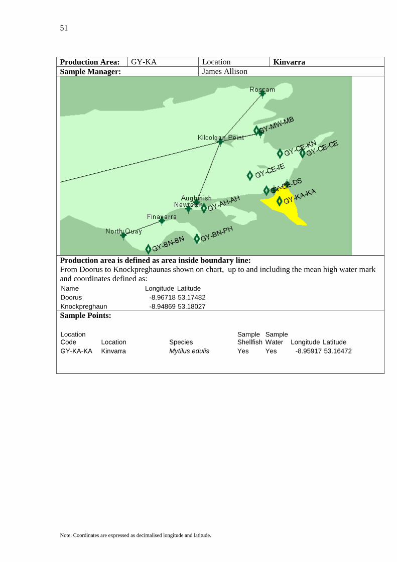
Production Area: GY-KA Location Kinvarra Sample Manager: James Allison
Production area is defined as area inside boundary line: From Doorus to Knockpreghaunas shown on chart, up to and including the mean high water mark and coordinates defined as: Name Longitude Latitude Doorus -8.96718 53.17482 Knockpreghaun -8.94869 53.18027
Sample Points:
Location Code Location Species
Sample Shellfish
Sample Water Longitude Latitude
GY-KA-KA Kinvarra Mytilus edulis Yes Yes -8.95917 53.16472
52
Note: Coordinates are expressed as decimalised longitude and latitude.
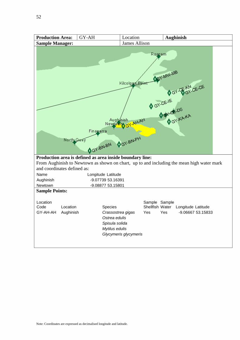
Production Area: GY-AH Location Aughinish Sample Manager: James Allison
Production area is defined as area inside boundary line: From Aughinish to Newtown as shown on chart, up to and including the mean high water mark and coordinates defined as: Name Longitude Latitude Aughinish -9.07739 53.16391 Newtown -9.08877 53.15801
Sample Points:
Location Code Location Species
Sample Shellfish
Sample Water Longitude Latitude
GY-AH-AH Aughinish Crassostrea gigas Yes Yes -9.06667 53.15833 Ostrea edulis Spisula solida Mytilus edulis Glycymeris glycymeris
53
Note: Coordinates are expressed as decimalised longitude and latitude.
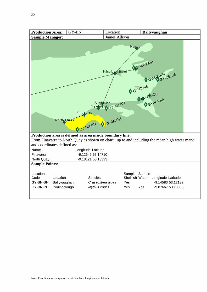
Production Area: GY-BN Location Ballyvaughan Sample Manager: James Allison
Production area is defined as area inside boundary line: From Finavarra to North Quay as shown on chart, up to and including the mean high water mark and coordinates defined as: Name Longitude Latitude Finavarra -9.12646 53.14710 North Quay -9.18121 53.13393
Sample Points:
Location Code Location Species
Sample Shellfish
Sample Water Longitude Latitude
GY-BN-BN Ballyvaughan Crassostrea gigas Yes -9.14583 53.12139 GY-BN-PH Poulnaclough Mytilus edulis Yes Yes -9.07667 53.13056
54
Note: Coordinates are expressed as decimalised longitude and latitude.
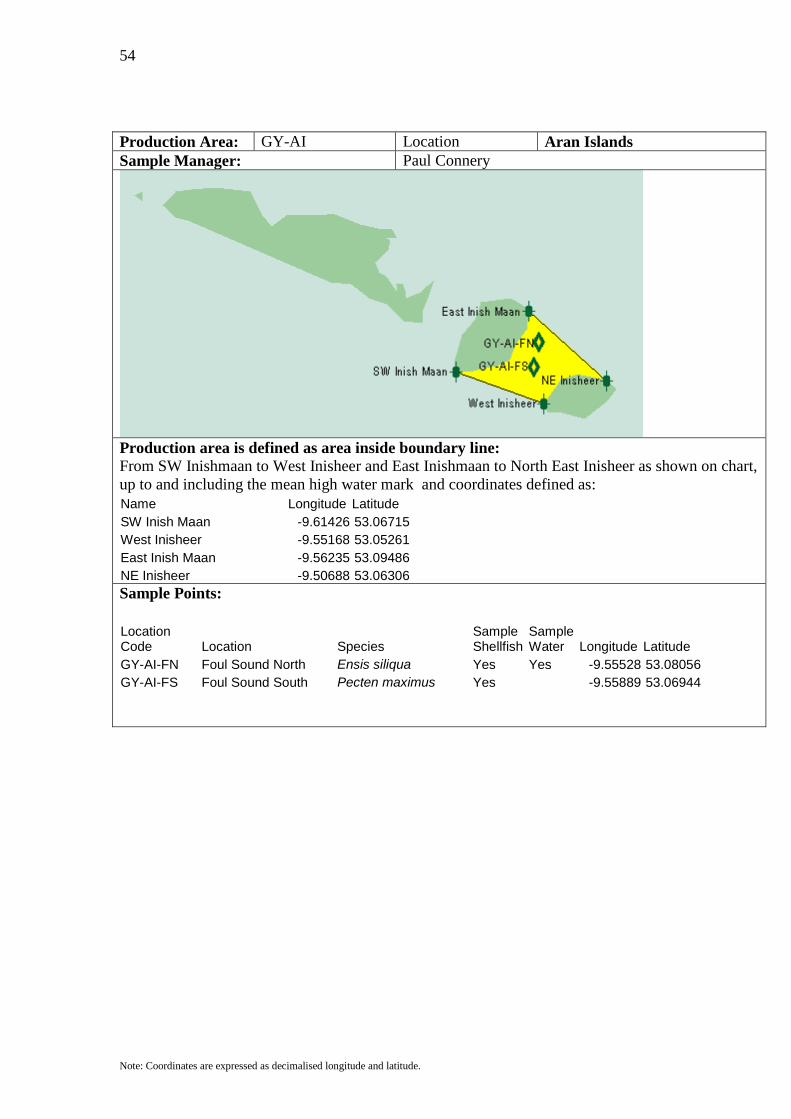
Production Area: GY-AI Location Aran Islands Sample Manager: Paul Connery
Production area is defined as area inside boundary line: From SW Inishmaan to West Inisheer and East Inishmaan to North East Inisheer as shown on chart, up to and including the mean high water mark and coordinates defined as: Name Longitude Latitude SW Inish Maan -9.61426 53.06715 West Inisheer -9.55168 53.05261 East Inish Maan -9.56235 53.09486 NE Inisheer -9.50688 53.06306
Sample Points:
Location Code Location Species
Sample Shellfish
Sample Water Longitude Latitude
GY-AI-FN Foul Sound North Ensis siliqua Yes Yes -9.55528 53.08056 GY-AI-FS Foul Sound South Pecten maximus Yes -9.55889 53.06944
55
Note: Coordinates are expressed as decimalised longitude and latitude.
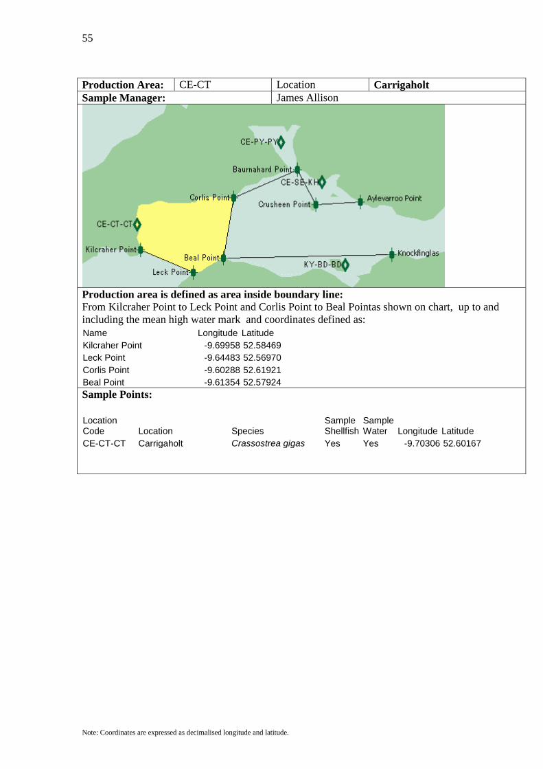
Production Area: CE-CT Location Carrigaholt Sample Manager: James Allison
Production area is defined as area inside boundary line: From Kilcraher Point to Leck Point and Corlis Point to Beal Pointas shown on chart, up to and including the mean high water mark and coordinates defined as: Name Longitude Latitude Kilcraher Point -9.69958 52.58469 Leck Point -9.64483 52.56970 Corlis Point -9.60288 52.61921 Beal Point -9.61354 52.57924
Sample Points:
Location Code Location Species
Sample Shellfish
Sample Water Longitude Latitude
CE-CT-CT Carrigaholt Crassostrea gigas Yes Yes -9.70306 52.60167
56
Note: Coordinates are expressed as decimalised longitude and latitude.
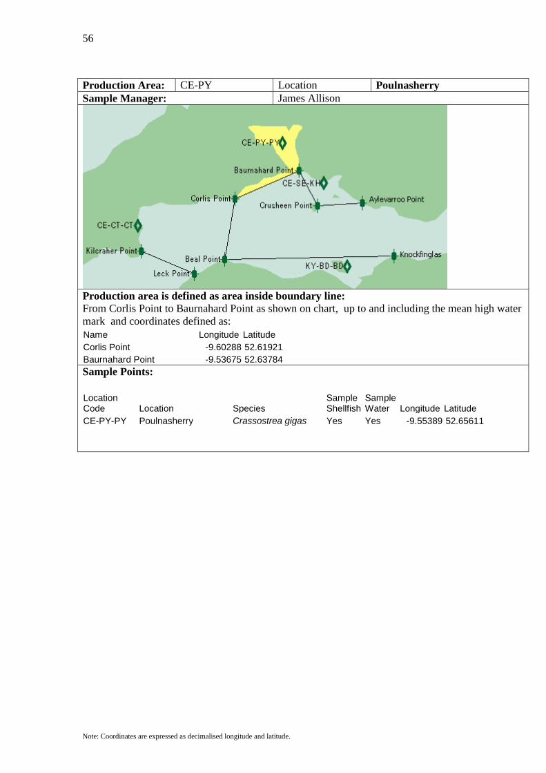
Production Area: CE-PY Location Poulnasherry Sample Manager: James Allison
Production area is defined as area inside boundary line: From Corlis Point to Baurnahard Point as shown on chart, up to and including the mean high water mark and coordinates defined as: Name Longitude Latitude Corlis Point -9.60288 52.61921 Baurnahard Point -9.53675 52.63784
Sample Points:
Location Code Location Species
Sample Shellfish
Sample Water Longitude Latitude
CE-PY-PY Poulnasherry Crassostrea gigas Yes Yes -9.55389 52.65611

57
Note: Coordinates are expressed as decimalised longitude and latitude.
Production Area: CE-SH Location Shannon Estuary Sample Manager: James Allison
Production area is defined as area inside boundary line: From Baurnahard Point to Crusheen Point to Aylevaroo Point as shown on chart, up to and including the mean high water mark and coordinates defined as: Name Longitude Latitude Baurnahard Point -9.53675 52.63784 Crusheen Point -9.51755 52.61467 Aylevaroo Point -9.47133 52.61649
Sample Points:
Location Code Location Species
Sample Shellfish
Sample Water Longitude Latitude
CE-SE-KH Kilrush Crassostrea gigas Yes Yes -9.51083 52.62944
58
Note: Coordinates are expressed as decimalised longitude and latitude.
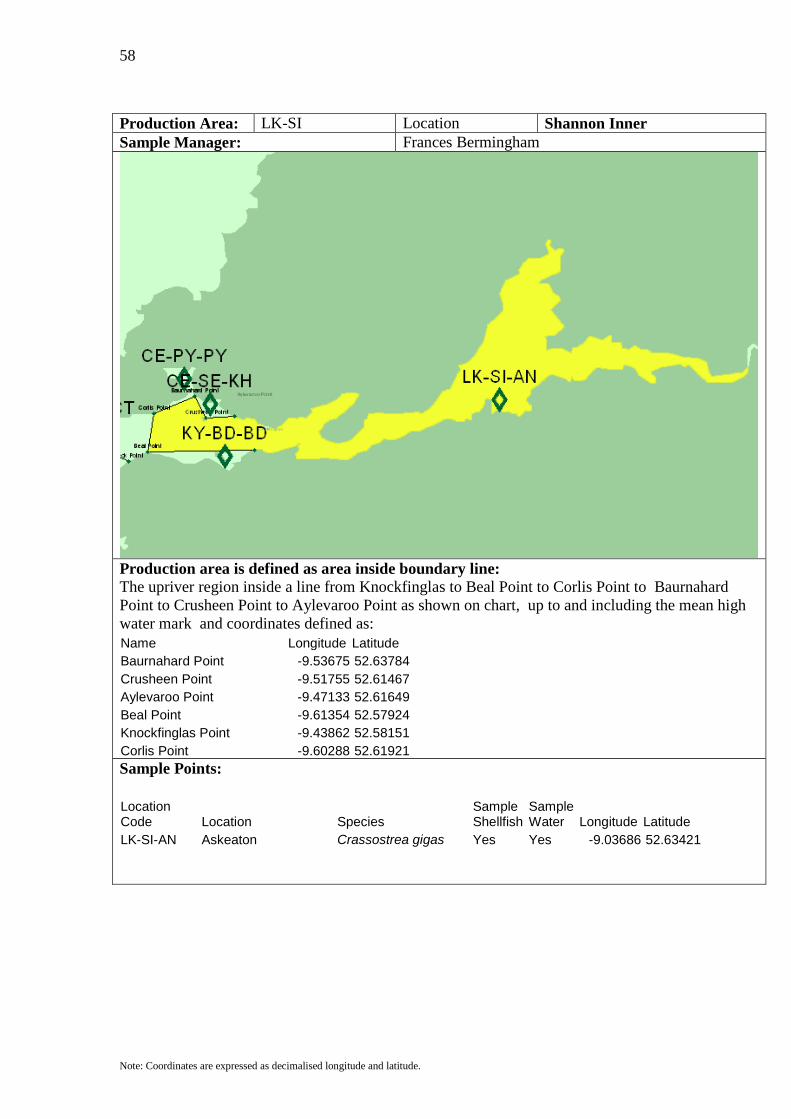
Production Area: LK-SI Location Shannon Inner Sample Manager: Frances Bermingham
Production area is defined as area inside boundary line: The upriver region inside a line from Knockfinglas to Beal Point to Corlis Point to Baurnahard Point to Crusheen Point to Aylevaroo Point as shown on chart, up to and including the mean high water mark and coordinates defined as: Name Longitude Latitude Baurnahard Point -9.53675 52.63784 Crusheen Point -9.51755 52.61467 Aylevaroo Point -9.47133 52.61649 Beal Point -9.61354 52.57924 Knockfinglas Point -9.43862 52.58151 Corlis Point -9.60288 52.61921
Sample Points:
Location Code Location Species
Sample Shellfish
Sample Water Longitude Latitude
LK-SI-AN Askeaton Crassostrea gigas Yes Yes -9.03686 52.63421
59
Note: Coordinates are expressed as decimalised longitude and latitude.
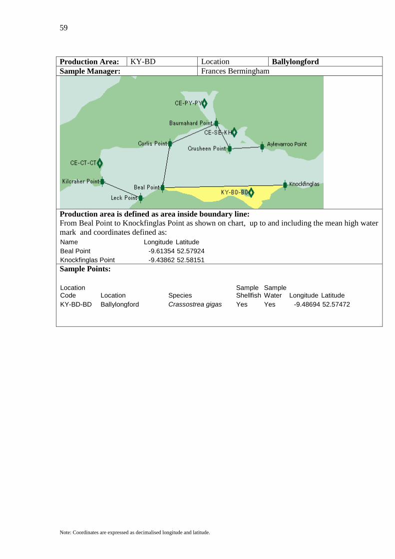
Production Area: KY-BD Location Ballylongford Sample Manager: Frances Bermingham
Production area is defined as area inside boundary line: From Beal Point to Knockfinglas Point as shown on chart, up to and including the mean high water mark and coordinates defined as: Name Longitude Latitude Beal Point -9.61354 52.57924 Knockfinglas Point -9.43862 52.58151
Sample Points:
Location Code Location Species
Sample Shellfish
Sample Water Longitude Latitude
KY-BD-BD Ballylongford Crassostrea gigas Yes Yes -9.48694 52.57472
60
Note: Coordinates are expressed as decimalised longitude and latitude.
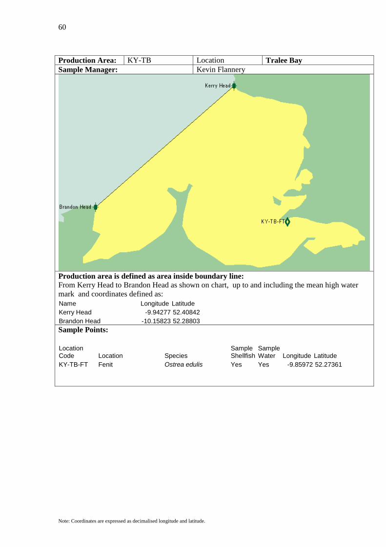
Production Area: KY-TB Location Tralee Bay Sample Manager: Kevin Flannery
Production area is defined as area inside boundary line: From Kerry Head to Brandon Head as shown on chart, up to and including the mean high water mark and coordinates defined as: Name Longitude Latitude Kerry Head -9.94277 52.40842 Brandon Head -10.15823 52.28803
Sample Points:
Location Code Location Species
Sample Shellfish
Sample Water Longitude Latitude
KY-TB-FT Fenit Ostrea edulis Yes Yes -9.85972 52.27361
61
Note: Coordinates are expressed as decimalised longitude and latitude.
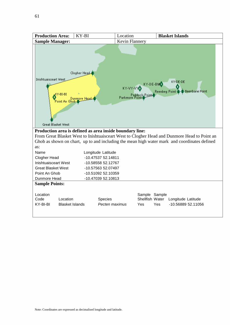
Production Area: KY-BI Location Blasket Islands Sample Manager: Kevin Flannery
Production area is defined as area inside boundary line: From Great Blasket West to Inishtuaisceart West to Clogher Head and Dunmore Head to Point an Ghob as shown on chart, up to and including the mean high water mark and coordinates defined as: Name Longitude Latitude Clogher Head -10.47537 52.14811 Inishtuaisceart West -10.58558 52.12767 Great Blasket West -10.57563 52.07497 Point An Ghob -10.51092 52.10359 Dunmore Head -10.47039 52.10813
Sample Points:
Location Code Location Species
Sample Shellfish
Sample Water Longitude Latitude
KY-BI-BI Blasket Islands Pecten maximus Yes Yes -10.56889 52.11056
62
Note: Coordinates are expressed as decimalised longitude and latitude.
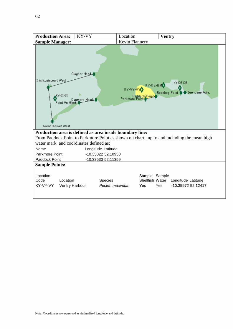
Production Area: KY-VY Location Ventry Sample Manager: Kevin Flannery
Production area is defined as area inside boundary line: From Paddock Point to Parkmore Point as shown on chart, up to and including the mean high water mark and coordinates defined as: Name Longitude Latitude Parkmore Point -10.35022 52.10950 Paddock Point -10.32533 52.11359
Sample Points:
Location Code Location Species
Sample Shellfish
Sample Water Longitude Latitude
KY-VY-VY Ventry Harbour Pecten maximus Yes Yes -10.35972 52.12417
63
Note: Coordinates are expressed as decimalised longitude and latitude.
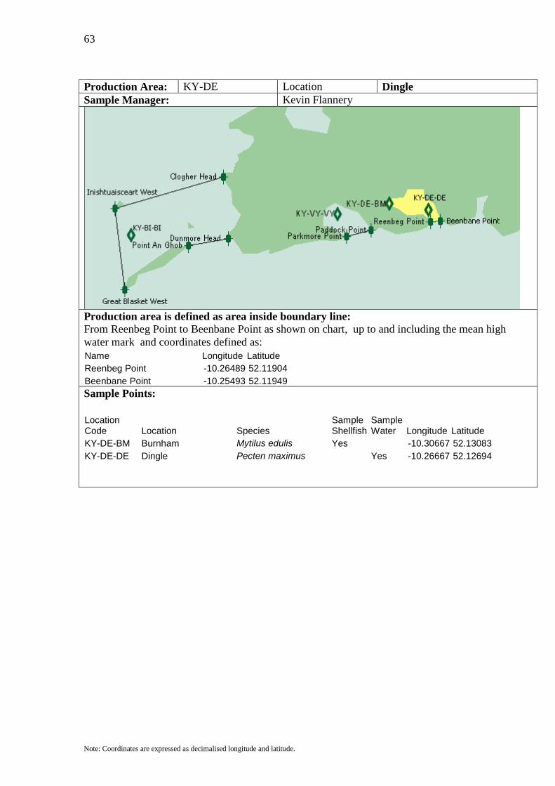
Production Area: KY-DE Location Dingle Sample Manager: Kevin Flannery
Production area is defined as area inside boundary line: From Reenbeg Point to Beenbane Point as shown on chart, up to and including the mean high water mark and coordinates defined as: Name Longitude Latitude Reenbeg Point -10.26489 52.11904 Beenbane Point -10.25493 52.11949
Sample Points:
Location Code Location Species
Sample Shellfish
Sample Water Longitude Latitude
KY-DE-BM Burnham Mytilus edulis Yes -10.30667 52.13083 KY-DE-DE Dingle Pecten maximus Yes -10.26667 52.12694
64
Note: Coordinates are expressed as decimalised longitude and latitude.
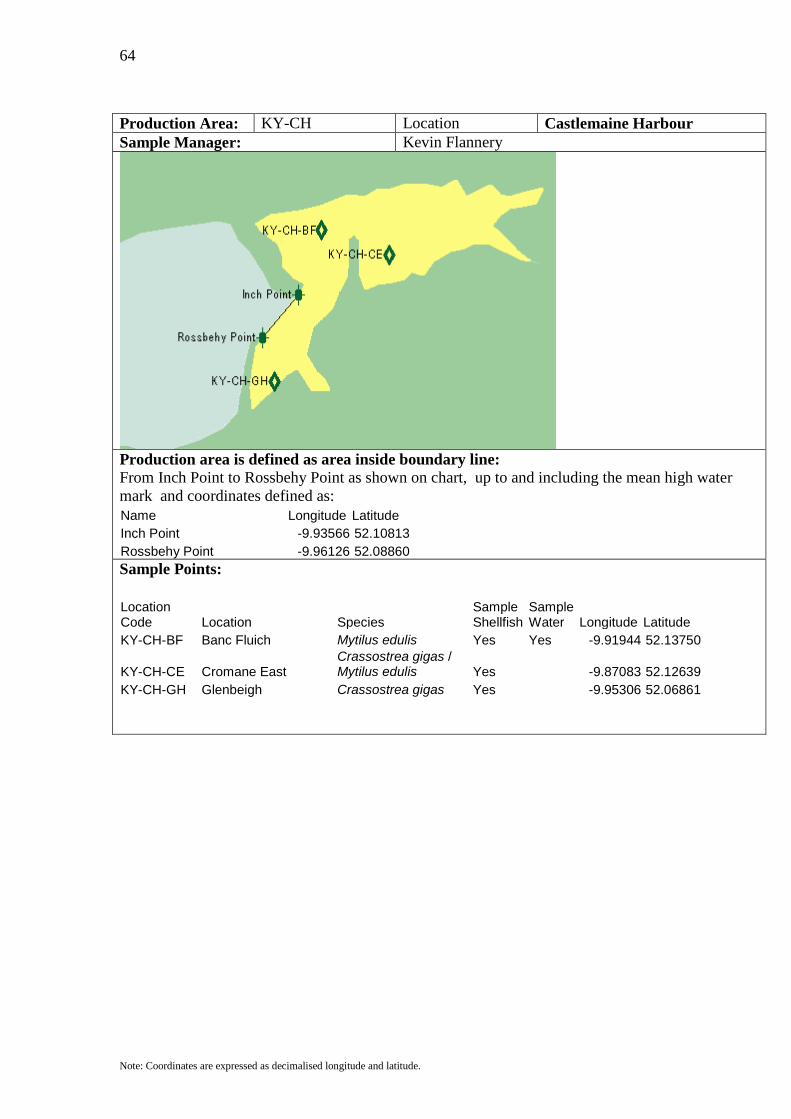
Production Area: KY-CH Location Castlemaine Harbour Sample Manager: Kevin Flannery
Production area is defined as area inside boundary line: From Inch Point to Rossbehy Point as shown on chart, up to and including the mean high water mark and coordinates defined as: Name Longitude Latitude Inch Point -9.93566 52.10813 Rossbehy Point -9.96126 52.08860
Sample Points:
Location Code Location Species
Sample Shellfish
Sample Water Longitude Latitude
KY-CH-BF Banc Fluich Mytilus edulis Yes Yes -9.91944 52.13750
KY-CH-CE Cromane East Crassostrea gigas / Mytilus edulis Yes -9.87083 52.12639
KY-CH-GH Glenbeigh Crassostrea gigas Yes -9.95306 52.06861
65
Note: Coordinates are expressed as decimalised longitude and latitude.
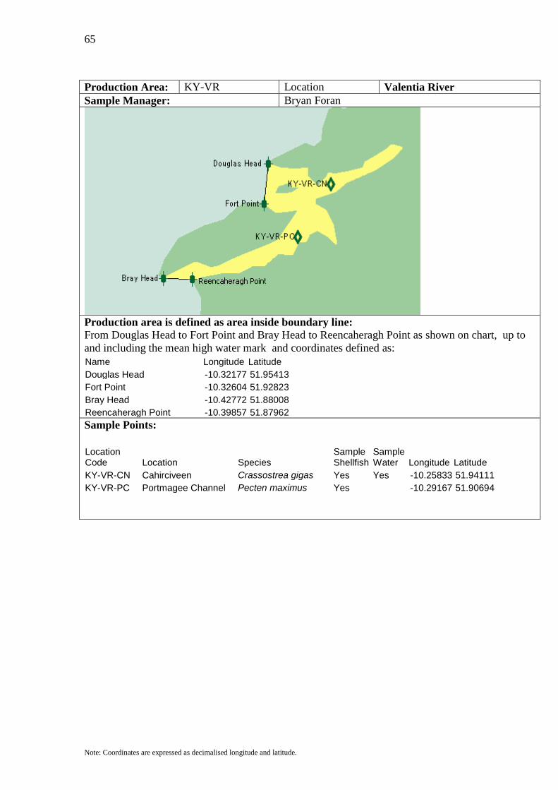
Production Area: KY-VR Location Valentia River Sample Manager: Bryan Foran
Production area is defined as area inside boundary line: From Douglas Head to Fort Point and Bray Head to Reencaheragh Point as shown on chart, up to and including the mean high water mark and coordinates defined as: Name Longitude Latitude Douglas Head -10.32177 51.95413 Fort Point -10.32604 51.92823 Bray Head -10.42772 51.88008 Reencaheragh Point -10.39857 51.87962
Sample Points:
Location Code Location Species
Sample Shellfish
Sample Water Longitude Latitude
KY-VR-CN Cahirciveen Crassostrea gigas Yes Yes -10.25833 51.94111 KY-VR-PC Portmagee Channel Pecten maximus Yes -10.29167 51.90694

66
Note: Coordinates are expressed as decimalised longitude and latitude.
Production Area: KY-KE Location Kilmakilloge Sample Manager: Cliona O’Shea
Production area is defined as area inside boundary line: From Laughanacreen to Laughran Point as shown on chart, up to and including the mean high water mark and coordinates defined as: Name Longitude Latitude Laughaunacreen -9.82473 51.78195 Laughran Point -9.84607 51.77196
Sample Points:
Location Code Location Species
Sample Shellfish
Sample Water Longitude Latitude
KY-KE-KE Kilmakilloge Mytilus edulis Yes Yes -9.81194 51.77194 Littorina littorea

67
Note: Coordinates are expressed as decimalised longitude and latitude.
Production Area: KY-KO Location Kenmare Outer Sample Manager: Kevin Flannery/Grant Fulton
Production area is defined as area inside boundary line: From Lambs Head to Cods Head and Shamrock Cliff to Dog Point to Laughran Point to Laughanacreen and Lackeen to Derrynid and Carrigfada to Rossmorebullig as shown on chart, up to and including the mean high water mark and coordinates defined as: Name Longitude Latitude Lackeen -9.73585 51.84782 Derrynid -9.72305 51.83783 Laughaunacreen -9.82473 51.78195 Laughran Point -9.84607 51.77196 Dog Point -9.88162 51.76196 Shamrock Cliff -9.95842 51.73834 Cods Head -10.10205 51.66974 Lambs Head -10.12978 51.74061 Carrigfada -9.83398 51.81557 Rossmorebullig -9.80838 51.82102
Sample Points:
Location Code Location Species
Sample Shellfish
Sample Water Longitude Latitude
KY-KO-KR Kenmare River Pecten maximus/ Yes Yes -9.88750 51.77694 Mytilus edulis KY-KO-CE Coosmore Mytilus edulis Yes Yes -9.91461 51.76219 KY-KO-GK Gleesk Mytilus edulis Yes Yes -9.93959 51.79127
68
Note: Coordinates are expressed as decimalised longitude and latitude.
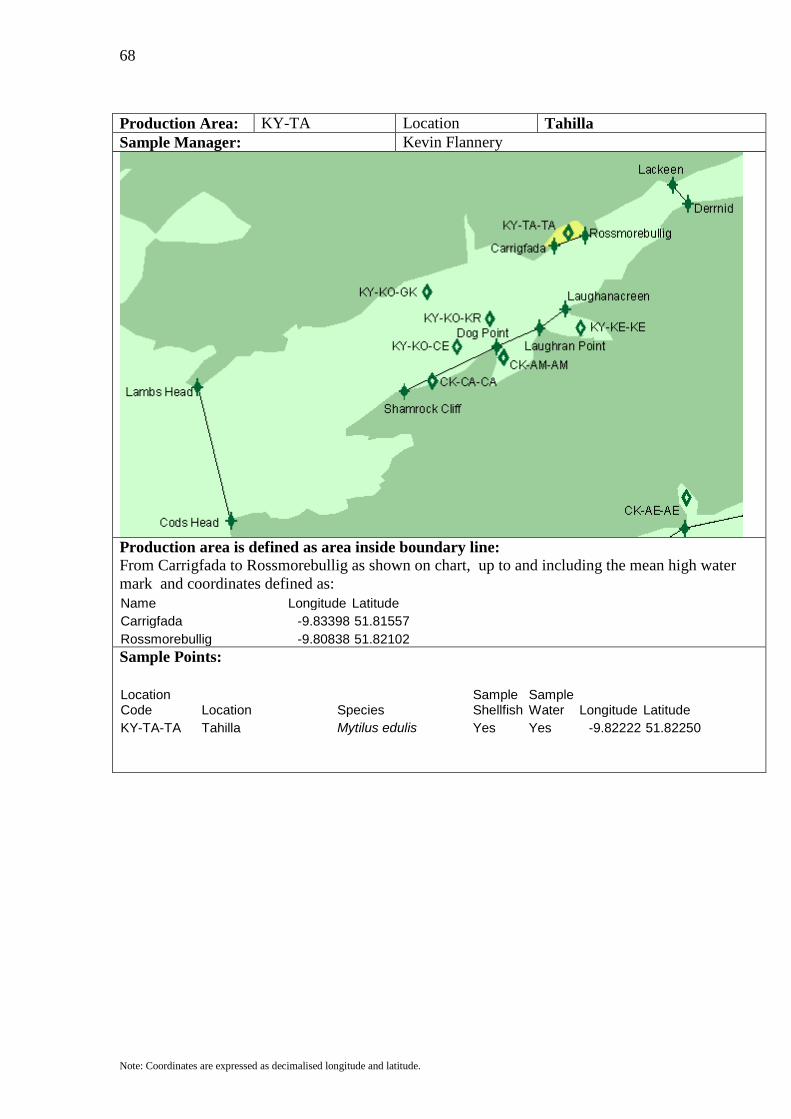
Production Area: KY-TA Location Tahilla Sample Manager: Kevin Flannery
Production area is defined as area inside boundary line: From Carrigfada to Rossmorebullig as shown on chart, up to and including the mean high water mark and coordinates defined as: Name Longitude Latitude Carrigfada -9.83398 51.81557 Rossmorebullig -9.80838 51.82102
Sample Points:
Location Code Location Species
Sample Shellfish
Sample Water Longitude Latitude
KY-TA-TA Tahilla Mytilus edulis Yes Yes -9.82222 51.82250
69
Note: Coordinates are expressed as decimalised longitude and latitude.
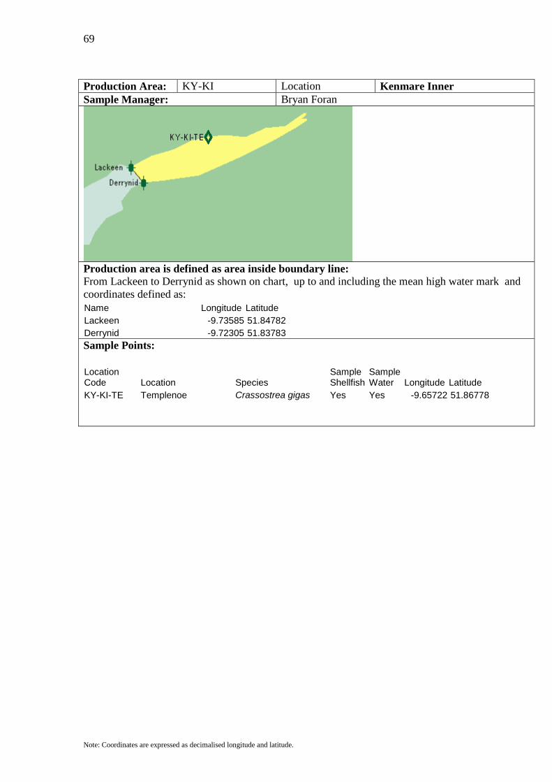
Production Area: KY-KI Location Kenmare Inner Sample Manager: Bryan Foran
Production area is defined as area inside boundary line: From Lackeen to Derrynid as shown on chart, up to and including the mean high water mark and coordinates defined as: Name Longitude Latitude Lackeen -9.73585 51.84782 Derrynid -9.72305 51.83783
Sample Points:
Location Code Location Species
Sample Shellfish
Sample Water Longitude Latitude
KY-KI-TE Templenoe Crassostrea gigas Yes Yes -9.65722 51.86778
70
Note: Coordinates are expressed as decimalised longitude and latitude.
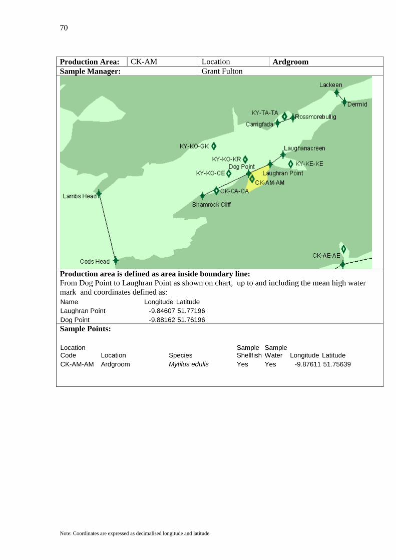
Production Area: CK-AM Location Ardgroom Sample Manager: Grant Fulton
Production area is defined as area inside boundary line: From Dog Point to Laughran Point as shown on chart, up to and including the mean high water mark and coordinates defined as: Name Longitude Latitude Laughran Point -9.84607 51.77196 Dog Point -9.88162 51.76196
Sample Points:
Location Code Location Species
Sample Shellfish
Sample Water Longitude Latitude
CK-AM-AM Ardgroom Mytilus edulis Yes Yes -9.87611 51.75639
71
Note: Coordinates are expressed as decimalised longitude and latitude.
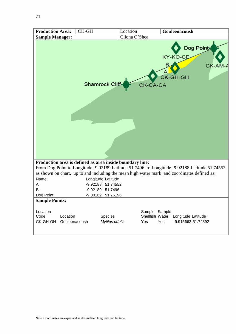
Production Area: CK-GH Location Gouleenacoush Sample Manager: Cliona O’Shea
Production area is defined as area inside boundary line: From Dog Point to Longitude -9.92189 Latitude 51.7496 to Longitude -9.92188 Latitude 51.74552 as shown on chart, up to and including the mean high water mark and coordinates defined as: Name Longitude Latitude A -9.92188 51.74552 B -9.92189 51.7496 Dog Point -9.88162 51.76196
Sample Points:
Location Code Location Species
Sample Shellfish
Sample Water Longitude Latitude
CK-GH-GH Gouleenacoush Mytilus edulis Yes Yes -9.915662 51.74892

72
Note: Coordinates are expressed as decimalised longitude and latitude.
Production Area: CK-CA Location Cleandra Sample Manager: Cliona O’Shea
Production area is defined as area inside boundary line: From Shamrock Cliff to Longitude -9.92189 Latitude 51.7496 to Longitude -9.92188 Latitude 51.74552 as shown on chart, up to and including the mean high water mark and coordinates defined as: Name Longitude Latitude A -9.92188 51.74552 B -9.92189 51.7496 Shamrock Cliff -9.95842 51.7383
Sample Points:
Location Code Location Species
Sample Shellfish
Sample Water Longitude Latitude
CK-CA-CA Cleandra Mytilus edulis Yes Yes -9.93495 51.74379
73
Note: Coordinates are expressed as decimalised longitude and latitude.
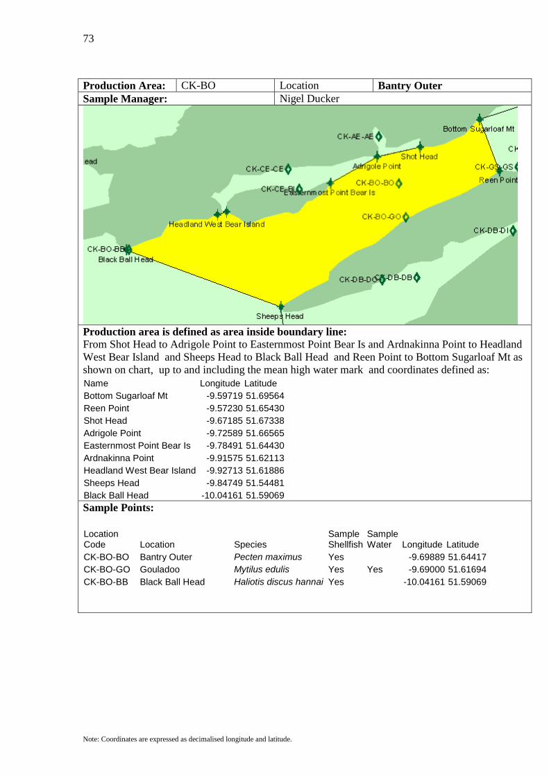
Production Area: CK-BO Location Bantry Outer Sample Manager: Nigel Ducker
Production area is defined as area inside boundary line: From Shot Head to Adrigole Point to Easternmost Point Bear Is and Ardnakinna Point to Headland West Bear Island and Sheeps Head to Black Ball Head and Reen Point to Bottom Sugarloaf Mt as shown on chart, up to and including the mean high water mark and coordinates defined as: Name Longitude Latitude Bottom Sugarloaf Mt -9.59719 51.69564 Reen Point -9.57230 51.65430 Shot Head -9.67185 51.67338 Adrigole Point -9.72589 51.66565 Easternmost Point Bear Is -9.78491 51.64430 Ardnakinna Point -9.91575 51.62113 Headland West Bear Island -9.92713 51.61886 Sheeps Head -9.84749 51.54481 Black Ball Head -10.04161 51.59069
Sample Points:
Location Code Location Species
Sample Shellfish
Sample Water Longitude Latitude
CK-BO-BO Bantry Outer Pecten maximus Yes -9.69889 51.64417 CK-BO-GO Gouladoo Mytilus edulis Yes Yes -9.69000 51.61694 CK-BO-BB Black Ball Head Haliotis discus hannai Yes -10.04161 51.59069
74
Note: Coordinates are expressed as decimalised longitude and latitude.
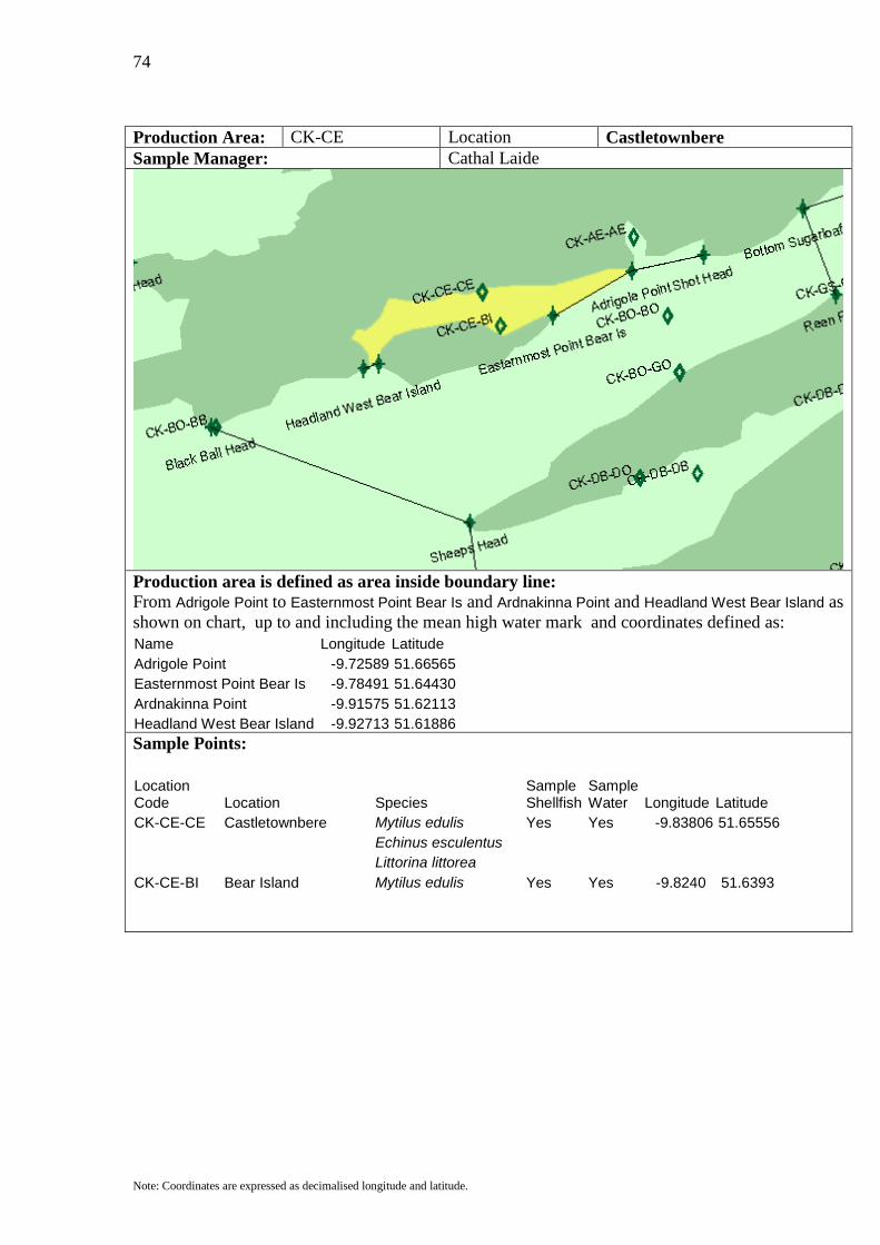
Production Area: CK-CE Location Castletownbere Sample Manager: Cathal Laide
Production area is defined as area inside boundary line: From Adrigole Point to Easternmost Point Bear Is and Ardnakinna Point and Headland West Bear Island as shown on chart, up to and including the mean high water mark and coordinates defined as: Name Longitude Latitude Adrigole Point -9.72589 51.66565 Easternmost Point Bear Is -9.78491 51.64430 Ardnakinna Point -9.91575 51.62113 Headland West Bear Island -9.92713 51.61886
Sample Points:
Location Code Location Species
Sample Shellfish
Sample Water Longitude Latitude
CK-CE-CE Castletownbere Mytilus edulis Yes Yes -9.83806 51.65556 Echinus esculentus Littorina littorea CK-CE-BI Bear Island Mytilus edulis Yes Yes -9.8240 51.6393
75
Note: Coordinates are expressed as decimalised longitude and latitude.
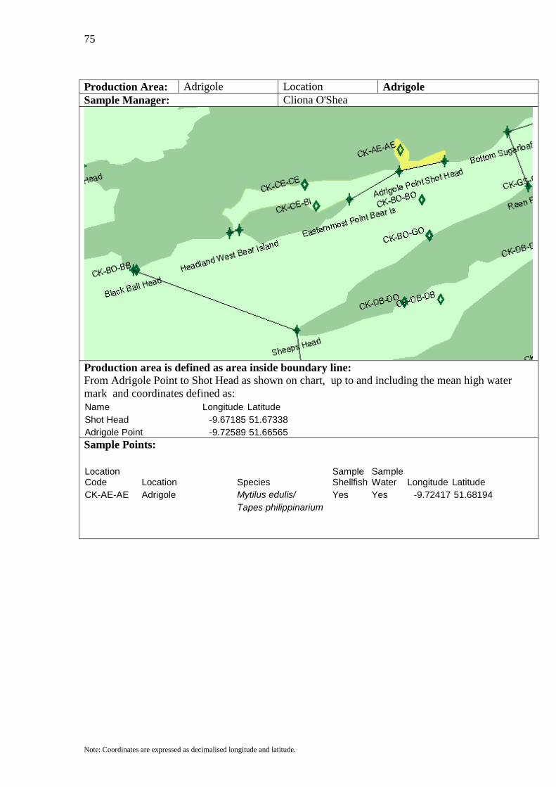
Production Area: Adrigole Location Adrigole Sample Manager: Cliona O'Shea
Production area is defined as area inside boundary line: From Adrigole Point to Shot Head as shown on chart, up to and including the mean high water mark and coordinates defined as: Name Longitude Latitude Shot Head -9.67185 51.67338 Adrigole Point -9.72589 51.66565
Sample Points:
Location Code Location Species
Sample Shellfish
Sample Water Longitude Latitude
CK-AE-AE Adrigole Mytilus edulis/ Yes Yes -9.72417 51.68194 Tapes philippinarium

76
Note: Coordinates are expressed as decimalised longitude and latitude.
Production Area: CK-GS Location Gearhies Sample Manager: Nigel Ducker
Production area is defined as area inside boundary line: From Whiddy Point to Reenagough Point to Bottom Sugarloaf Mt to Reen Point andSouth Beach to North Beach as shown on chart, up to and including the mean high water mark and coordinates defined as: Name Longitude Latitude Whiddy Point -9.48342 51.70381 Reenagough Point -9.49835 51.71608 Bottom Sugarloaf Mt -9.59719 51.69564 Reen Point -9.57230 51.65430
Sample Points:
Location Code Location Species
Sample Shellfish
Sample Water Longitude Latitude
CK-GS-BH Beach Paracentrotus lividus Yes -9.50722 51.67167 CK-GS-GS Gearhies Mytilus edulis Yes Yes -9.54889 51.65750
77
Note: Coordinates are expressed as decimalised longitude and latitude.
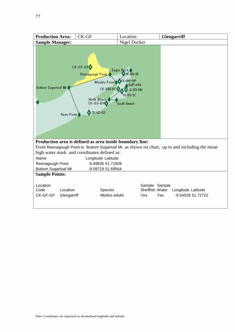
Production Area: CK-GF Location Glengarriff Sample Manager: Nigel Ducker
Production area is defined as area inside boundary line: From Reenagough Point to Bottom Sugarloaf Mt as shown on chart, up to and including the mean high water mark and coordinates defined as: Name Longitude Latitude Reenagough Point -9.49835 51.71608 Bottom Sugarloaf Mt -9.59719 51.69564
Sample Points:
Location Code Location Species
Sample Shellfish
Sample Water Longitude Latitude
CK-GF-GF Glengarriff Mytilus edulis Yes Yes -9.54528 51.72722
78
Note: Coordinates are expressed as decimalised longitude and latitude.
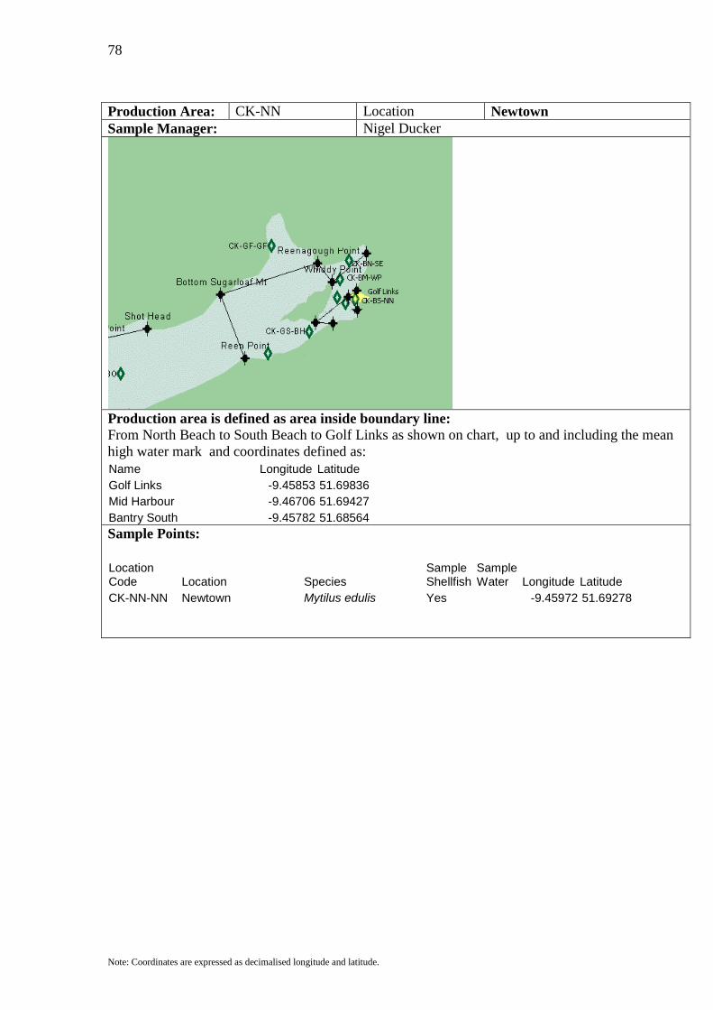
Production Area: CK-NN Location Newtown Sample Manager: Nigel Ducker
Production area is defined as area inside boundary line: From North Beach to South Beach to Golf Links as shown on chart, up to and including the mean high water mark and coordinates defined as: Name Longitude Latitude Golf Links -9.45853 51.69836 Mid Harbour -9.46706 51.69427 Bantry South -9.45782 51.68564
Sample Points:
Location Code Location Species
Sample Shellfish
Sample Water Longitude Latitude
CK-NN-NN Newtown Mytilus edulis Yes -9.45972 51.69278
79
Note: Coordinates are expressed as decimalised longitude and latitude.
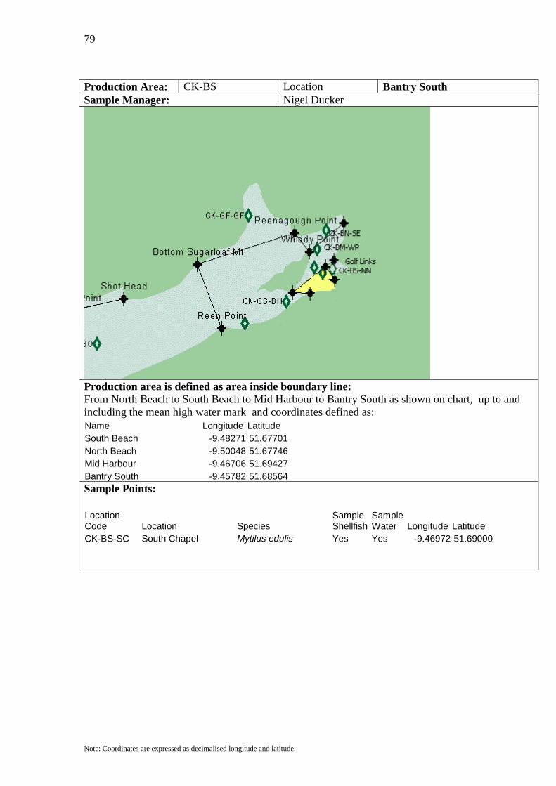
Production Area: CK-BS Location Bantry South Sample Manager: Nigel Ducker
Production area is defined as area inside boundary line: From North Beach to South Beach to Mid Harbour to Bantry South as shown on chart, up to and including the mean high water mark and coordinates defined as: Name Longitude Latitude South Beach -9.48271 51.67701 North Beach -9.50048 51.67746 Mid Harbour -9.46706 51.69427 Bantry South -9.45782 51.68564
Sample Points:
Location Code Location Species
Sample Shellfish
Sample Water Longitude Latitude
CK-BS-SC South Chapel Mytilus edulis Yes Yes -9.46972 51.69000

80
Note: Coordinates are expressed as decimalised longitude and latitude.
Production Area: CK-BM Location Bantry Middle Sample Manager: Nigel Ducker
Production area is defined as area inside boundary line: From North Beach to Golf Links and Whiddy Point to Eagle Rock as shown on chart, up to and including the mean high water mark and coordinates defined as: Name Longitude Latitude North Beach -9.50048 51.67746 Golf Links -9.45853 51.69836 Whiddy Point -9.48342 51.70381 Eagle Rock -9.44858 51.72244
Sample Points:
Location Code Location Species
Sample Shellfish
Sample Water Longitude Latitude
CK-BM-NC North Chapel Mytilus edulis Yes Yes -9.47833 51.69361 CK-BM-WP Whiddy Point Mytilus edulis Yes -9.47556 51.70556
81
Note: Coordinates are expressed as decimalised longitude and latitude.
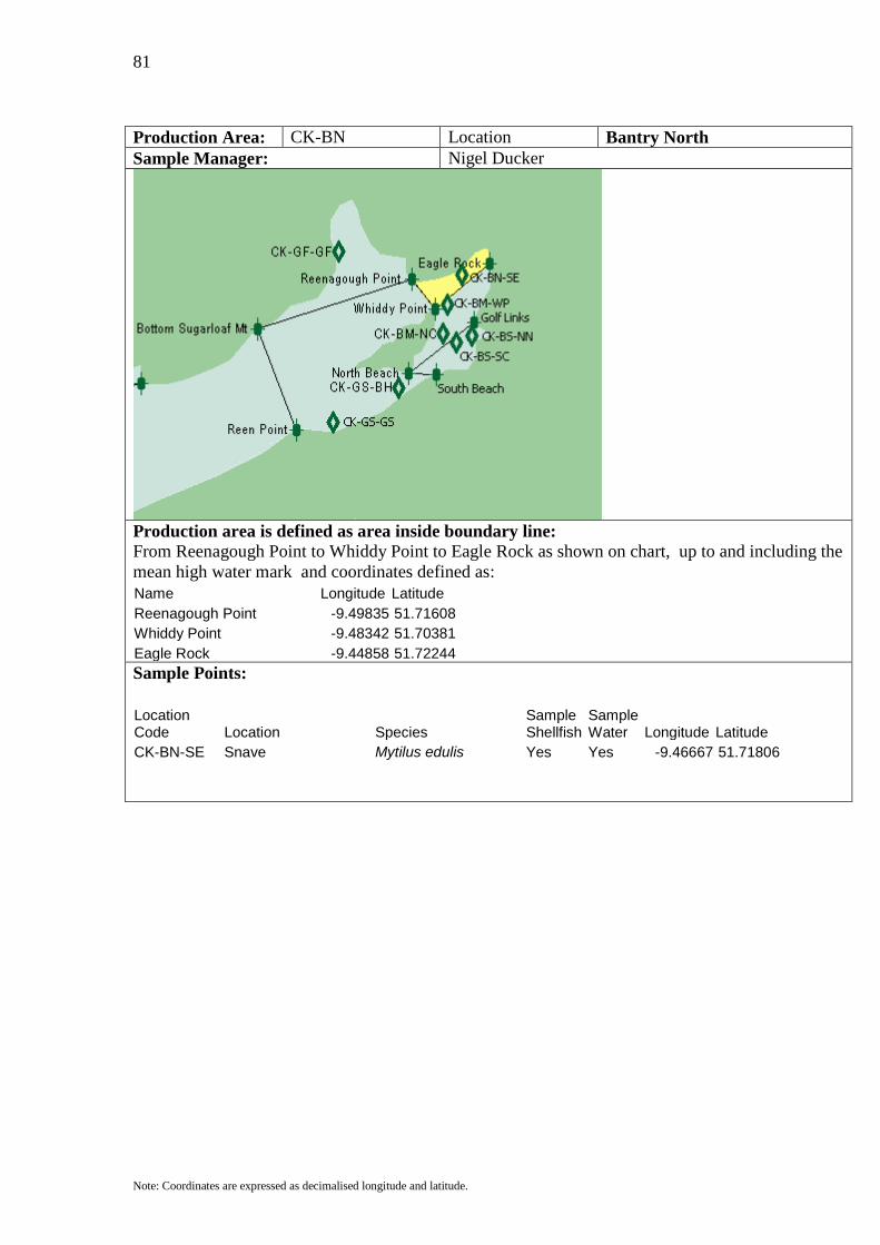
Production Area: CK-BN Location Bantry North Sample Manager: Nigel Ducker
Production area is defined as area inside boundary line: From Reenagough Point to Whiddy Point to Eagle Rock as shown on chart, up to and including the mean high water mark and coordinates defined as: Name Longitude Latitude Reenagough Point -9.49835 51.71608 Whiddy Point -9.48342 51.70381 Eagle Rock -9.44858 51.72244
Sample Points:
Location Code Location Species
Sample Shellfish
Sample Water Longitude Latitude
CK-BN-SE Snave Mytilus edulis Yes Yes -9.46667 51.71806

82
Note: Coordinates are expressed as decimalised longitude and latitude.
Production Area: CK-DB Location Dunmanus Bay Sample Manager: Nigel Ducker
Production area is defined as area inside boundary line: From Sheeps Head to Three Castle Head as shown on chart, up to and including the mean high water mark and coordinates defined as: Name Longitude Latitude Sheeps Head -9.84749 51.54481 Three Castle Head -9.83398 51.48303 Sample Points:
Location Code Location Species
Sample Shellfish
Sample Water Longitude Latitude
CK-DB-DB Dunmanus Bay Pecten maximus Yes -9.67639 51.56833 Mytilus edulis CK-DB-DI Dunmanus Inner Paracentrotus lividus Yes Yes -9.55528 51.60611 Mytilus edulis CK-DB-DO Dunmanus Outer Mytilus edulis Yes -9.71972 51.56639
83
Note: Coordinates are expressed as decimalised longitude and latitude.
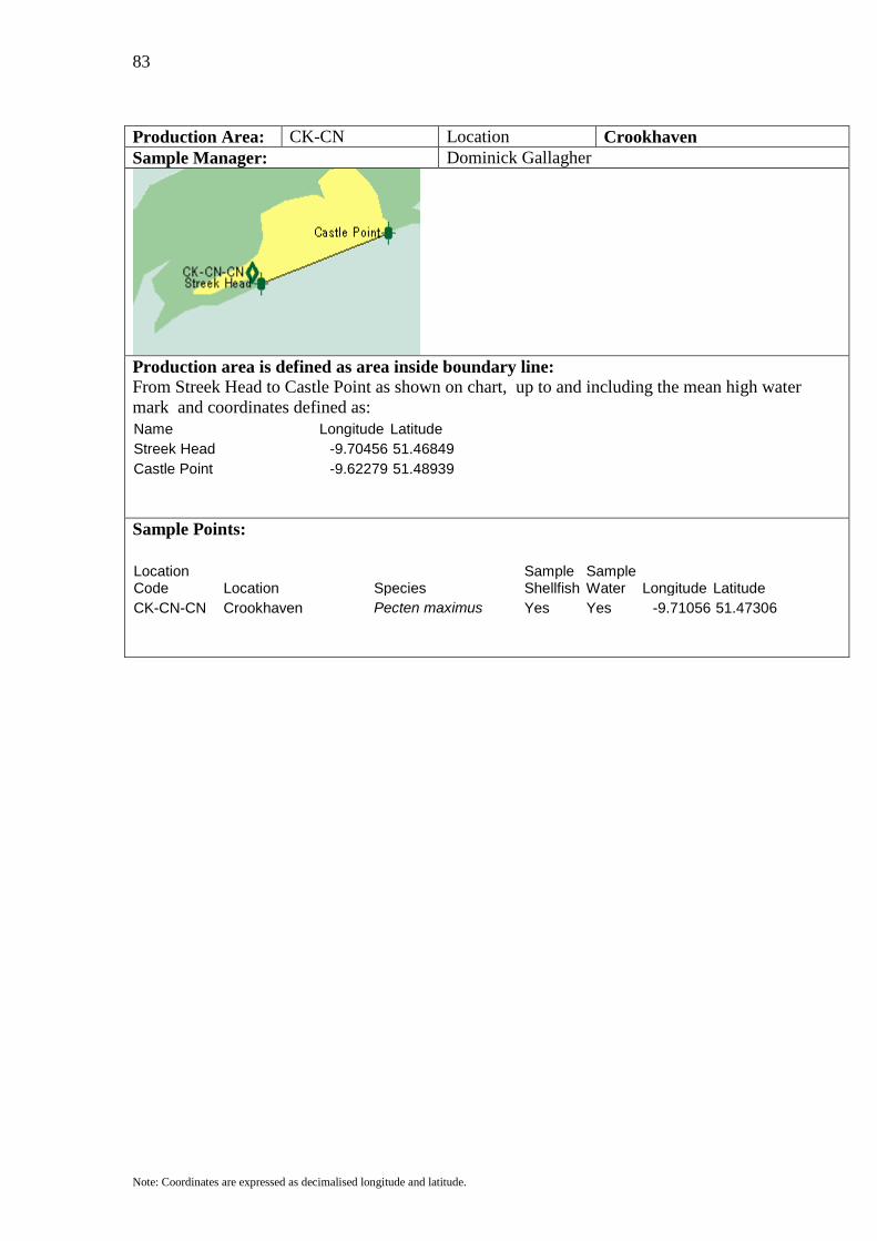
Production Area: CK-CN Location Crookhaven Sample Manager: Dominick Gallagher
Production area is defined as area inside boundary line: From Streek Head to Castle Point as shown on chart, up to and including the mean high water mark and coordinates defined as: Name Longitude Latitude Streek Head -9.70456 51.46849 Castle Point -9.62279 51.48939 Sample Points:
Location Code Location Species
Sample Shellfish
Sample Water Longitude Latitude
CK-CN-CN Crookhaven Pecten maximus Yes Yes -9.71056 51.47306
84
Note: Coordinates are expressed as decimalised longitude and latitude.
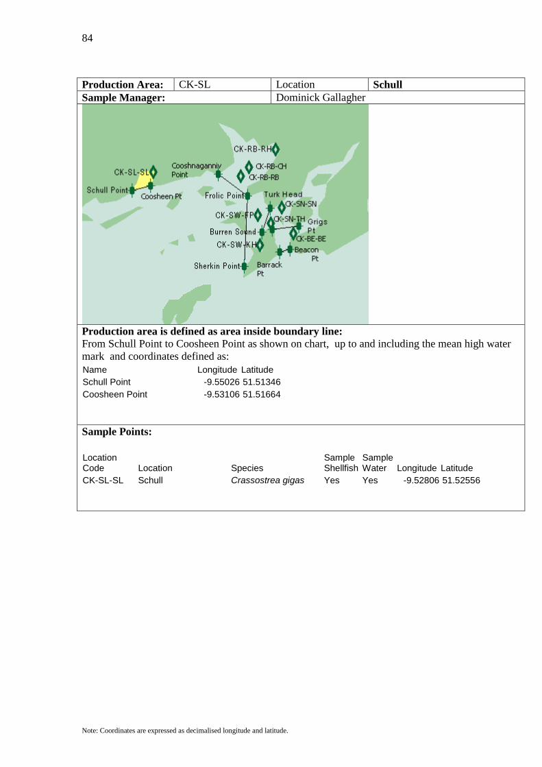
Production Area: CK-SL Location Schull Sample Manager: Dominick Gallagher
Production area is defined as area inside boundary line: From Schull Point to Coosheen Point as shown on chart, up to and including the mean high water mark and coordinates defined as: Name Longitude Latitude Schull Point -9.55026 51.51346 Coosheen Point -9.53106 51.51664 Sample Points:
Location Code Location Species
Sample Shellfish
Sample Water Longitude Latitude
CK-SL-SL Schull Crassostrea gigas Yes Yes -9.52806 51.52556

85
Note: Coordinates are expressed as decimalised longitude and latitude.
Production Area: CK-RB Location Roaringwater Bay Sample Manager: Grant Fulton
Production area is defined as area inside boundary line: From Cooshaganniv Point to Frolic Point as shown on chart, up to and including the mean high water mark and coordinates defined as: Name Longitude Latitude Coosnaganniv Point -9.46066 51.52437 Frolic Point -9.43009 51.50983
Sample Points:
Location Code Location Species
Sample Shellfish
Sample Water Longitude Latitude
CK-RB-CH Carrigviglash Mytilus edulis Yes Yes -9.42861 51.52889 CK-RB-RB Roaringwater Bay Pecten maximus / Yes -9.43694 51.52306 Mytilus edulis CK-RB-RH Reenmurrish Mytilus edulis Yes -9.40111 51.54083
86
Note: Coordinates are expressed as decimalised longitude and latitude.
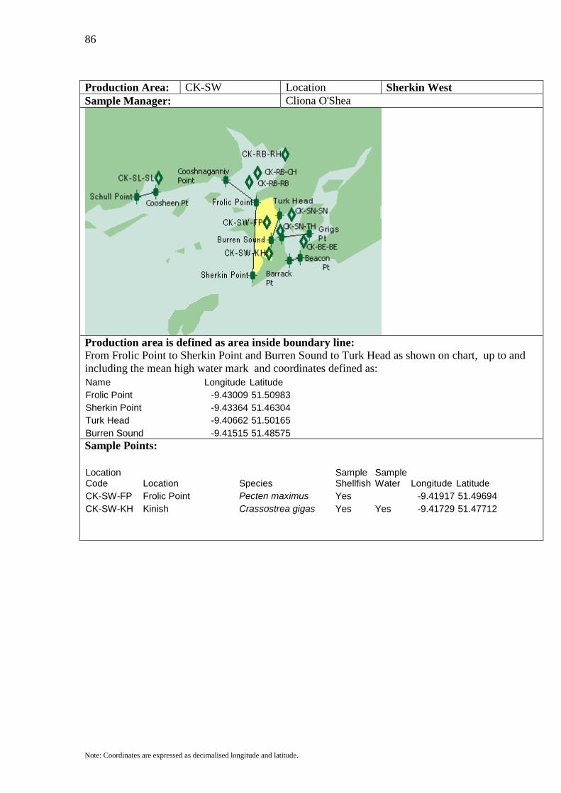
Production Area: CK-SW Location Sherkin West Sample Manager: Cliona O'Shea
Production area is defined as area inside boundary line: From Frolic Point to Sherkin Point and Burren Sound to Turk Head as shown on chart, up to and including the mean high water mark and coordinates defined as: Name Longitude Latitude Frolic Point -9.43009 51.50983 Sherkin Point -9.43364 51.46304 Turk Head -9.40662 51.50165 Burren Sound -9.41515 51.48575
Sample Points:
Location Code Location Species
Sample Shellfish
Sample Water Longitude Latitude
CK-SW-FP Frolic Point Pecten maximus Yes -9.41917 51.49694 CK-SW-KH Kinish Crassostrea gigas Yes Yes -9.41729 51.47712

87
Note: Coordinates are expressed as decimalised longitude and latitude.
Production Area: CK-SN Location Sherkin North Sample Manager: Cliona O'Shea
Production area is defined as area inside boundary line: From Burren Sound to Turk Head and Grigs Point to East Farranacoush as shown on chart, up to and including the mean high water mark and coordinates defined as: Name Longitude Latitude Turk Head -9.40662 51.50165 Burren Sound -9.41515 51.48575 East Farranacoush -9.40449 51.48757 Grigs Point -9.37676 51.48984 Sample Points:
Location Code Location Species
Sample Shellfish
Sample Water Longitude Latitude
CK-SN-SN Sherkin North Crassostrea gigas Yes Yes -9.39444 51.50194 CK-SN-TH Turk Head Crassostrea gigas Yes -9.40583 51.49167

88
Note: Coordinates are expressed as decimalised longitude and latitude.
Production Area: CK-BE Location Baltimore Sample Manager: Cathal laide
Production area is defined as area inside boundary line: From Grigs Point to East Farranacoush and Beacon Point to Barrack Point as shown on chart, up to and including the mean high water mark and coordinates defined as: Name Longitude Latitude East Farranacoush -9.40449 51.48757 Grigs Point -9.37676 51.48984 Barrack Point -9.39667 51.47258 Beacon Point -9.38600 51.47440
Sample Points:
Location Code Location Species
Sample Shellfish
Sample Water Longitude Latitude
CK-BE-BE Baltimore Crassostrea gigas Yes Yes -9.38245 51.48484
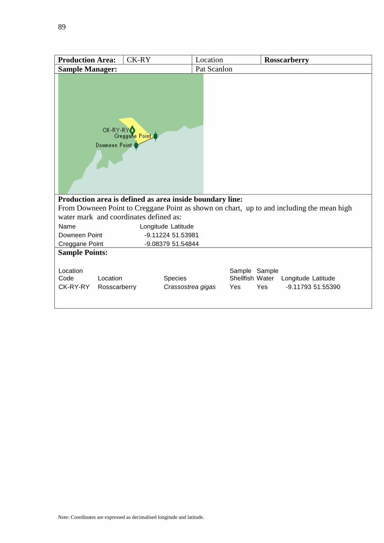
89
Note: Coordinates are expressed as decimalised longitude and latitude.
Production Area: CK-RY Location Rosscarberry Sample Manager: Pat Scanlon
Production area is defined as area inside boundary line: From Downeen Point to Creggane Point as shown on chart, up to and including the mean high water mark and coordinates defined as: Name Longitude Latitude Downeen Point -9.11224 51.53981 Creggane Point -9.08379 51.54844
Sample Points:
Location Code Location Species
Sample Shellfish
Sample Water Longitude Latitude
CK-RY-RY Rosscarberry Crassostrea gigas Yes Yes -9.11793 51.55390
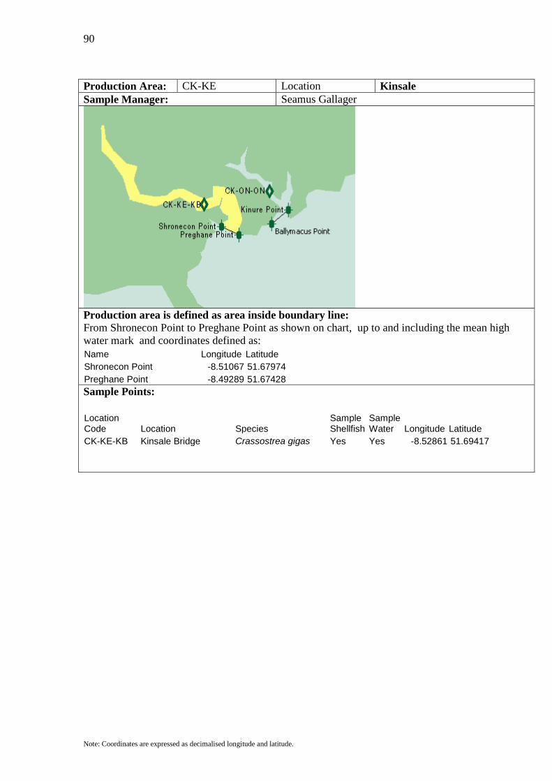
90
Note: Coordinates are expressed as decimalised longitude and latitude.
Production Area: CK-KE Location Kinsale Sample Manager: Seamus Gallager
Production area is defined as area inside boundary line: From Shronecon Point to Preghane Point as shown on chart, up to and including the mean high water mark and coordinates defined as: Name Longitude Latitude Shronecon Point -8.51067 51.67974 Preghane Point -8.49289 51.67428
Sample Points:
Location Code Location Species
Sample Shellfish
Sample Water Longitude Latitude
CK-KE-KB Kinsale Bridge Crassostrea gigas Yes Yes -8.52861 51.69417

91
Note: Coordinates are expressed as decimalised longitude and latitude.
Production Area: CK-ON Location Oysterhaven Sample Manager: Seamus Gallagher
Production area is defined as area inside boundary line: From Kinure Point to Ballymacus Point as shown on chart, up to and including the mean high water mark and coordinates defined as: Name Longitude Latitude Ballymacus Point -8.45947 51.68155 Kinure Point -8.44241 51.69064
Sample Points:
Location Code Location Species
Sample Shellfish
Sample Water Longitude Latitude
CK-ON-ON Oysterhaven Crassostrea gigas Yes Yes -8.46194 51.70306
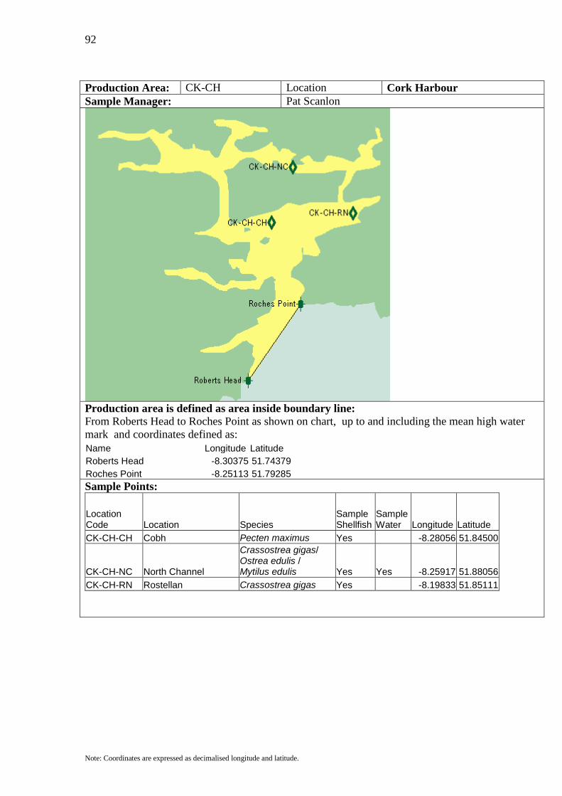
92
Note: Coordinates are expressed as decimalised longitude and latitude.
Production Area: CK-CH Location Cork Harbour Sample Manager: Pat Scanlon
Production area is defined as area inside boundary line: From Roberts Head to Roches Point as shown on chart, up to and including the mean high water mark and coordinates defined as: Name Longitude Latitude Roberts Head -8.30375 51.74379 Roches Point -8.25113 51.79285
Sample Points:
Location Code Location Species
Sample Shellfish
Sample Water Longitude Latitude
CK-CH-CH Cobh Pecten maximus Yes -8.28056 51.84500
CK-CH-NC North Channel
Crassostrea gigas/ Ostrea edulis / Mytilus edulis Yes Yes -8.25917 51.88056
CK-CH-RN Rostellan Crassostrea gigas Yes -8.19833 51.85111
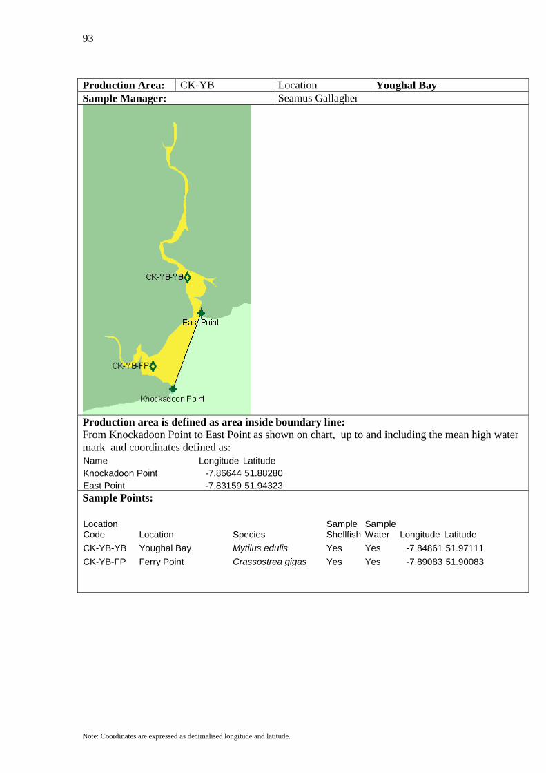
93
Note: Coordinates are expressed as decimalised longitude and latitude.
Production Area: CK-YB Location Youghal Bay Sample Manager: Seamus Gallagher
Production area is defined as area inside boundary line: From Knockadoon Point to East Point as shown on chart, up to and including the mean high water mark and coordinates defined as: Name Longitude Latitude Knockadoon Point -7.86644 51.88280 East Point -7.83159 51.94323
Sample Points:
Location Code Location Species
Sample Shellfish
Sample Water Longitude Latitude
CK-YB-YB Youghal Bay Mytilus edulis Yes Yes -7.84861 51.97111 CK-YB-FP Ferry Point Crassostrea gigas Yes Yes -7.89083 51.90083

94
Note: Coordinates are expressed as decimalised longitude and latitude.
Production Area: WD-DB Location Dungarvan Bay Sample Manager: Kevin Hewson
Production area is defined as area inside boundary line: From Ballnacourty Point to Helvick Head as shown on chart, up to and including the mean high water mark and coordinates defined as: Name Longitude Latitude Helvick Head -7.53721 52.05226 Ballnacourty Point -7.55143 52.07861
Sample Points:
Location Code Location Species
Sample Shellfish
Sample Water Longitude Latitude
WD-DB-DN Dungarvan North Crassostrea gigas Yes Yes -7.58722 52.07472 WD-DB-DS Dungarvan South Crassostrea gigas Yes -7.58250 52.05861
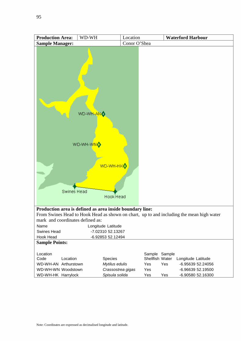
95
Note: Coordinates are expressed as decimalised longitude and latitude.
Production Area: WD-WH Location Waterford Harbour Sample Manager: Conor O’Shea
Production area is defined as area inside boundary line: From Swines Head to Hook Head as shown on chart, up to and including the mean high water mark and coordinates defined as: Name Longitude Latitude Swines Head -7.02310 52.13267 Hook Head -6.92853 52.12494
Sample Points:
Location Code Location Species
Sample Shellfish
Sample Water Longitude Latitude
WD-WH-AN Arthurstown Mytilus edulis Yes Yes -6.95639 52.24056 WD-WH-WN Woodstown Crassostrea gigas Yes -6.96639 52.19500 WD-WH-HK Harrylock Spisula solida Yes Yes -6.90580 52.16300
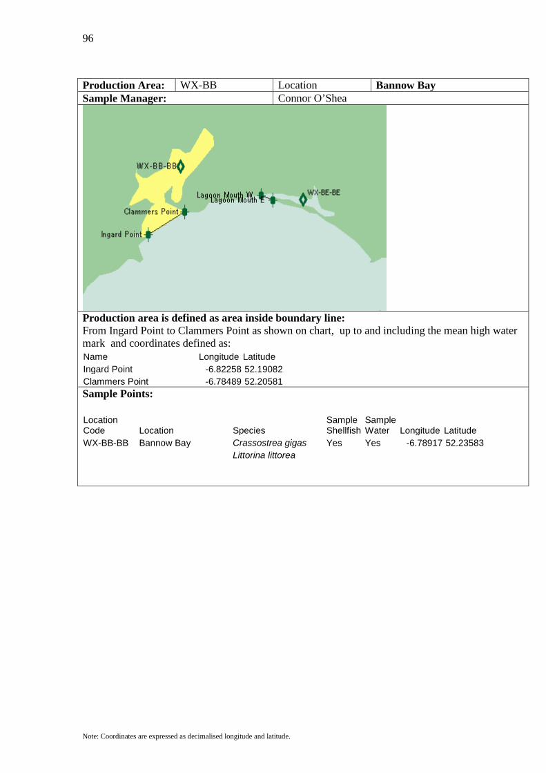
96
Note: Coordinates are expressed as decimalised longitude and latitude.
Production Area: WX-BB Location Bannow Bay Sample Manager: Connor O’Shea
Production area is defined as area inside boundary line: From Ingard Point to Clammers Point as shown on chart, up to and including the mean high water mark and coordinates defined as: Name Longitude Latitude Ingard Point -6.82258 52.19082 Clammers Point -6.78489 52.20581
Sample Points:
Location Code Location Species
Sample Shellfish
Sample Water Longitude Latitude
WX-BB-BB Bannow Bay Crassostrea gigas Yes Yes -6.78917 52.23583 Littorina littorea
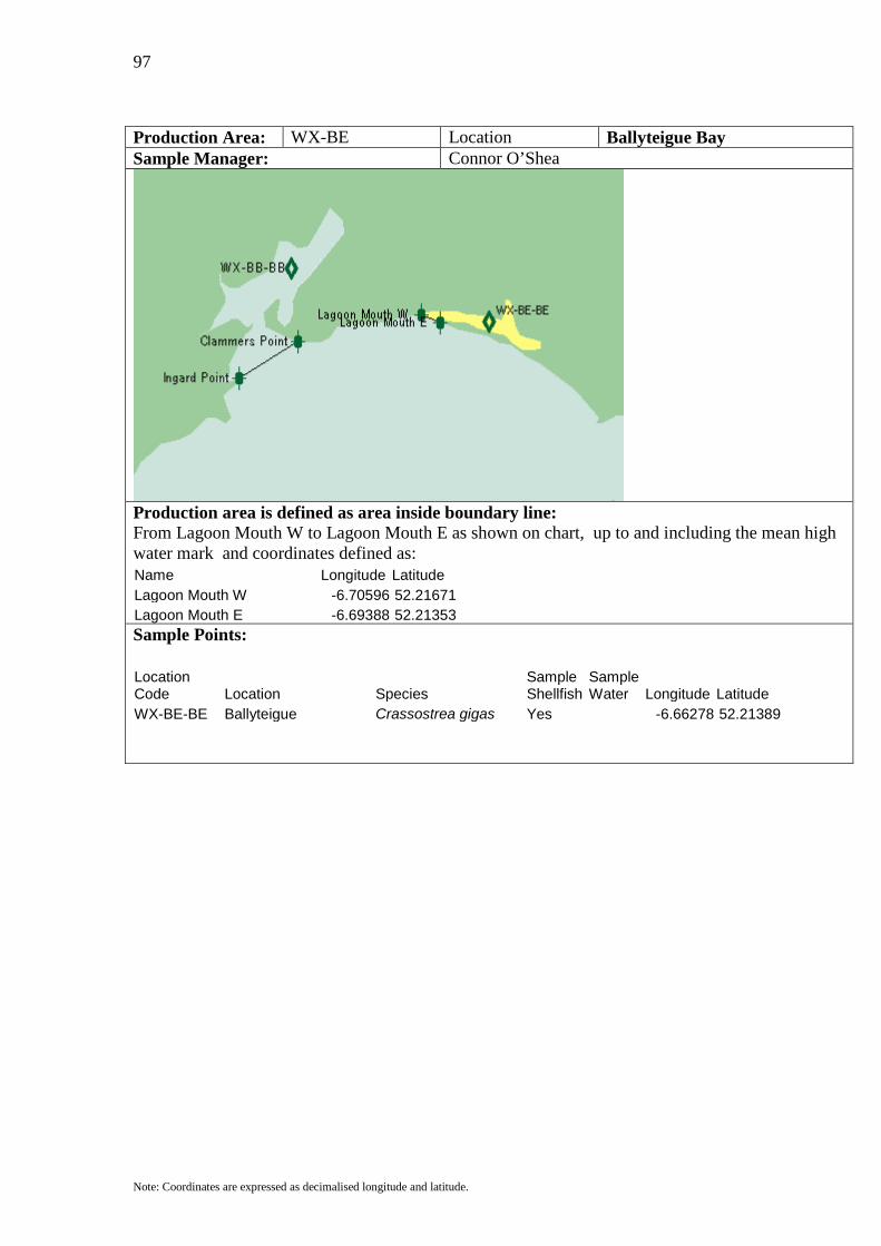
97
Note: Coordinates are expressed as decimalised longitude and latitude.
Production Area: WX-BE Location Ballyteigue Bay Sample Manager: Connor O’Shea
Production area is defined as area inside boundary line: From Lagoon Mouth W to Lagoon Mouth E as shown on chart, up to and including the mean high water mark and coordinates defined as: Name Longitude Latitude Lagoon Mouth W -6.70596 52.21671 Lagoon Mouth E -6.69388 52.21353
Sample Points:
Location Code Location Species
Sample Shellfish
Sample Water Longitude Latitude
WX-BE-BE Ballyteigue Crassostrea gigas Yes -6.66278 52.21389

98
Note: Coordinates are expressed as decimalised longitude and latitude.
Production Area: WX-RE Location Rosslare Sample Manager: Eugene Wallace
Production area is defined as area inside boundary line: From Rosslare Point to Latitude 52.30575 N / Longitude 6.34 W to Rosslare Harbour as shown on chart, up to and including the mean high water mark and coordinates defined as: Name Longitude Latitude Rosslare Point -6.38954 52.30575 A -6.34 52.30575 Rosslare Harbour -6.34 52.255
Sample Points:
Location Code Location Species
Sample Shellfish
Sample Water Longitude Latitude
WX-RE-RE Rosslare Ensis siliqua Yes Yes -6.35667 52.27 Buccinum undatum
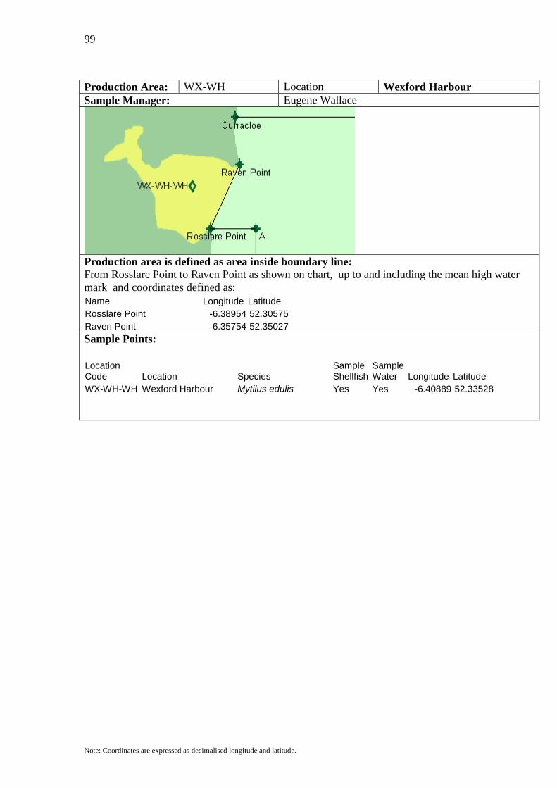
99
Note: Coordinates are expressed as decimalised longitude and latitude.
Production Area: WX-WH Location Wexford Harbour Sample Manager: Eugene Wallace
Production area is defined as area inside boundary line: From Rosslare Point to Raven Point as shown on chart, up to and including the mean high water mark and coordinates defined as: Name Longitude Latitude Rosslare Point -6.38954 52.30575 Raven Point -6.35754 52.35027
Sample Points:
Location Code Location Species
Sample Shellfish
Sample Water Longitude Latitude
WX-WH-WH Wexford Harbour Mytilus edulis Yes Yes -6.40889 52.33528
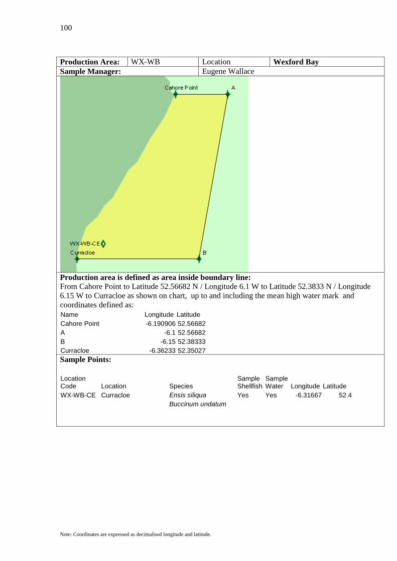
100
Note: Coordinates are expressed as decimalised longitude and latitude.
Production Area: WX-WB Location Wexford Bay Sample Manager: Eugene Wallace
Production area is defined as area inside boundary line: From Cahore Point to Latitude 52.56682 N / Longitude 6.1 W to Latitude 52.3833 N / Longitude 6.15 W to Curracloe as shown on chart, up to and including the mean high water mark and coordinates defined as: Name Longitude Latitude Cahore Point -6.190906 52.56682 A -6.1 52.56682 B -6.15 52.38333 Curracloe -6.36233 52.35027
Sample Points:
Location Code Location Species
Sample Shellfish
Sample Water Longitude Latitude
WX-WB-CE Curracloe Ensis siliqua Yes Yes -6.31667 52.4 Buccinum undatum

101
Note: Coordinates are expressed as decimalised longitude and latitude.
Production Area: DN-ME Location Malahide Sample Manager: Anne Marie Carberry
Production area is defined as area inside boundary line: From Latitude 53.423 N to Latitude 53.49 N and From Longitude 6 W as shown on chart, up to and including the mean high water mark and coordinates defined as: Name Longitude Latitude A -6.12 53.423 B -6 53.423 C -6 53.49 D -6.104 53.49
Sample Points:
Location Code Location Species
Sample Shellfish
Sample Water Longitude Latitude
DN-ME-ME Malahide Ensis siliqua Yes Yes -6.02972 53.44833 Buccinum undatum
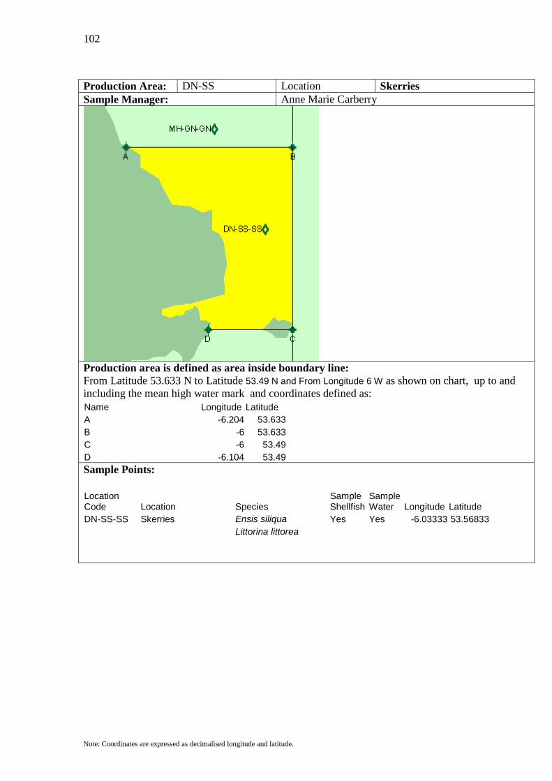
102
Note: Coordinates are expressed as decimalised longitude and latitude.
Production Area: DN-SS Location Skerries Sample Manager: Anne Marie Carberry
Production area is defined as area inside boundary line: From Latitude 53.633 N to Latitude 53.49 N and From Longitude 6 W as shown on chart, up to and including the mean high water mark and coordinates defined as: Name Longitude Latitude A -6.204 53.633 B -6 53.633 C -6 53.49 D -6.104 53.49
Sample Points:
Location Code Location Species
Sample Shellfish
Sample Water Longitude Latitude
DN-SS-SS Skerries Ensis siliqua Yes Yes -6.03333 53.56833 Littorina littorea
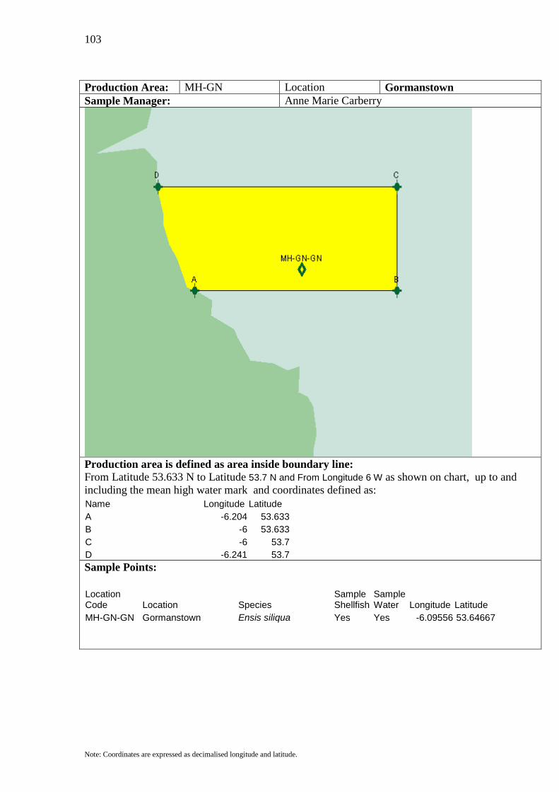
103
Note: Coordinates are expressed as decimalised longitude and latitude.
Production Area: MH-GN Location Gormanstown Sample Manager: Anne Marie Carberry
Production area is defined as area inside boundary line: From Latitude 53.633 N to Latitude 53.7 N and From Longitude 6 W as shown on chart, up to and including the mean high water mark and coordinates defined as: Name Longitude Latitude A -6.204 53.633 B -6 53.633 C -6 53.7 D -6.241 53.7
Sample Points:
Location Code Location Species
Sample Shellfish
Sample Water Longitude Latitude
MH-GN-GN Gormanstown Ensis siliqua Yes Yes -6.09556 53.64667
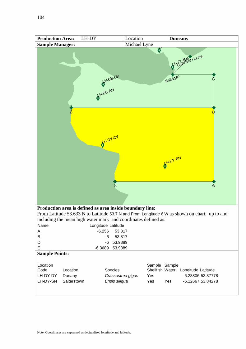
104
Note: Coordinates are expressed as decimalised longitude and latitude.
Production Area: LH-DY Location Duneany Sample Manager: Michael Lyne
Production area is defined as area inside boundary line: From Latitude 53.633 N to Latitude 53.7 N and From Longitude 6 W as shown on chart, up to and including the mean high water mark and coordinates defined as: Name Longitude Latitude A -6.256 53.817 B -6 53.817 D -6 53.9389 E -6.3689 53.9389
Sample Points:
Location Code Location Species
Sample Shellfish
Sample Water Longitude Latitude
LH-DY-DY Dunany Crassostrea gigas Yes -6.28806 53.87778 LH-DY-SN Salterstown Ensis siliqua Yes Yes -6.12667 53.84278
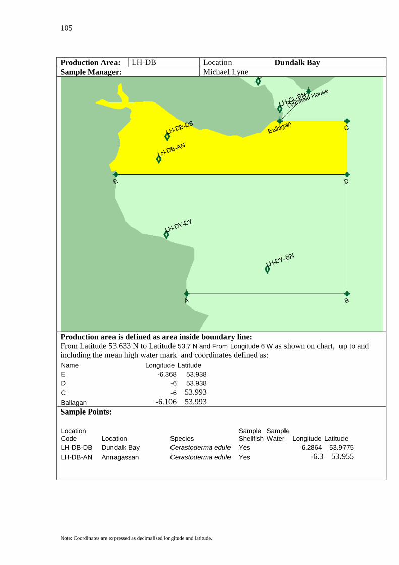
105
Note: Coordinates are expressed as decimalised longitude and latitude.
Production Area: LH-DB Location Dundalk Bay Sample Manager: Michael Lyne
Production area is defined as area inside boundary line: From Latitude 53.633 N to Latitude 53.7 N and From Longitude 6 W as shown on chart, up to and including the mean high water mark and coordinates defined as: Name Longitude Latitude E -6.368 53.938 D -6 53.938 C -6 53.993 Ballagan -6.106 53.993
Sample Points:
Location Code Location Species
Sample Shellfish
Sample Water Longitude Latitude
LH-DB-DB Dundalk Bay Cerastoderma edule Yes -6.2864 53.9775 LH-DB-AN Annagassan Cerastoderma edule Yes -6.3 53.955
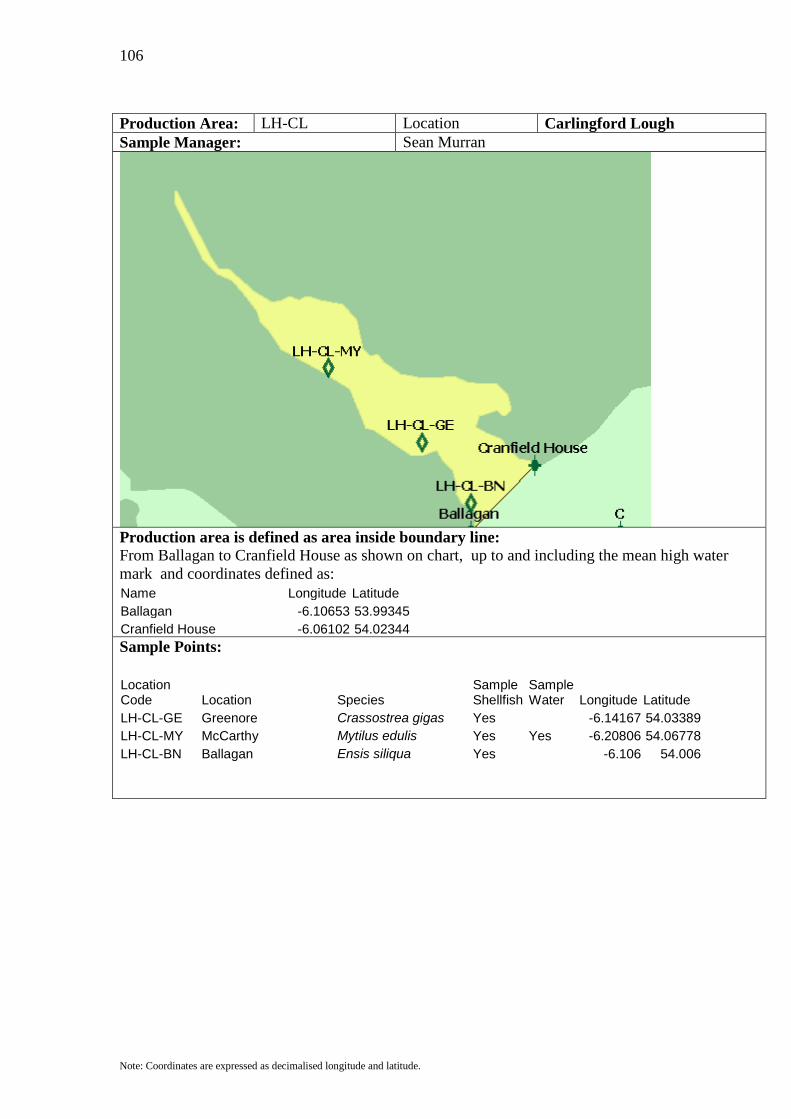
106
Note: Coordinates are expressed as decimalised longitude and latitude.
Production Area: LH-CL Location Carlingford Lough Sample Manager: Sean Murran
Production area is defined as area inside boundary line: From Ballagan to Cranfield House as shown on chart, up to and including the mean high water mark and coordinates defined as: Name Longitude Latitude Ballagan -6.10653 53.99345 Cranfield House -6.06102 54.02344
Sample Points:
Location Code Location Species
Sample Shellfish
Sample Water Longitude Latitude
LH-CL-GE Greenore Crassostrea gigas Yes -6.14167 54.03389 LH-CL-MY McCarthy Mytilus edulis Yes Yes -6.20806 54.06778 LH-CL-BN Ballagan Ensis siliqua Yes -6.106 54.006
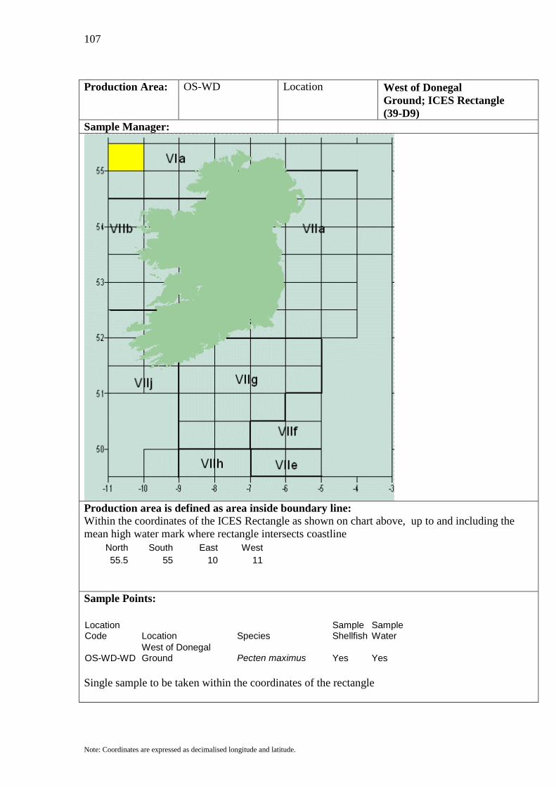
107
Note: Coordinates are expressed as decimalised longitude and latitude.
Production Area: OS-WD Location West of Donegal
Ground; ICES Rectangle (39-D9)
Sample Manager:
Production area is defined as area inside boundary line: Within the coordinates of the ICES Rectangle as shown on chart above, up to and including the mean high water mark where rectangle intersects coastline
North South East West 55.5 55 10 11
Sample Points:
Location Code Location Species
Sample Shellfish
Sample Water
OS-WD-WD West of Donegal Ground Pecten maximus Yes Yes
Single sample to be taken within the coordinates of the rectangle

108
Note: Coordinates are expressed as decimalised longitude and latitude.
Production Area: OS-DG Location Donegal Ground; ICES
Rectangle (39-E0) Sample Manager:
Production area is defined as area inside boundary line: Within the coordinates of the ICES Rectangle as shown on chart above, up to and including the mean high water mark where rectangle intersects coastline
North South East West 55.5 55 9 10
Sample Points:
Location Code Location Species
Sample Shellfish
Sample Water
OS-DG-DG Donegal Ground Pecten maximus Yes Yes Single sample to be taken within the coordinates of the rectangle

109
Note: Coordinates are expressed as decimalised longitude and latitude.
Production Area: OS-TI Location Tory Island Ground; ICES
Rectangle (39-E1) Sample Manager:
Production area is defined as area inside boundary line: Within the coordinates of the ICES Rectangle as shown on chart above, up to and including the mean high water mark where rectangle intersects coastline
North South East West 55.5 55 8 9
Sample Points:
Location Code Location Species
Sample Shellfish
Sample Water
OS-TI-TI Tory Island Ground Pecten maximus Yes Yes Single sample to be taken within the coordinates of the rectangle

110
Note: Coordinates are expressed as decimalised longitude and latitude.
Production Area: OS-MN Location Malin Head; ICES Rectangle
(39-E2) Sample Manager:
Production area is defined as area inside boundary line: Within the coordinates of the ICES Rectangle as shown on chart above, up to and including the mean high water mark where rectangle intersects coastline
North South East West 55.5 55 7 8
Sample Points:
Location Code Location Species
Sample Shellfish
Sample Water
OS-MN-MN Malin Head Pecten maximus Yes Yes Single sample to be taken within the coordinates of the rectangle

111
Note: Coordinates are expressed as decimalised longitude and latitude.
Production Area: OS-MG Location Middle Ground; ICES
Rectangle (39-E3) Sample Manager:
Production area is defined as area inside boundary line: Within the coordinates of the ICES Rectangle as shown on chart above, up to and including the mean high water mark where rectangle intersects coastline
North South East West 55.5 55 6 7
Sample Points:
Location Code Location Species
Sample Shellfish
Sample Water
OS-MG-MG Middle Ground Pecten maximus Yes Yes Single sample to be taken within the coordinates of the rectangle
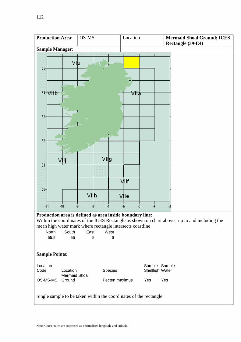
112
Note: Coordinates are expressed as decimalised longitude and latitude.
Production Area: OS-MS Location Mermaid Shoal Ground; ICES
Rectangle (39-E4) Sample Manager:
Production area is defined as area inside boundary line: Within the coordinates of the ICES Rectangle as shown on chart above, up to and including the mean high water mark where rectangle intersects coastline
North South East West 55.5 55 5 6
Sample Points:
Location Code Location Species
Sample Shellfish
Sample Water
OS-MS-MS Mermaid Shoal Ground Pecten maximus Yes Yes
Single sample to be taken within the coordinates of the rectangle
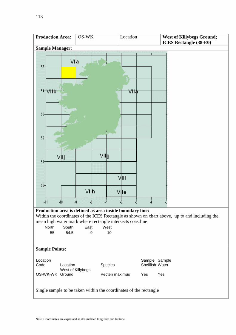
113
Note: Coordinates are expressed as decimalised longitude and latitude.
Production Area: OS-WK Location West of Killybegs Ground;
ICES Rectangle (38-E0) Sample Manager:
Production area is defined as area inside boundary line: Within the coordinates of the ICES Rectangle as shown on chart above, up to and including the mean high water mark where rectangle intersects coastline
North South East West 55 54.5 9 10
Sample Points:
Location Code Location Species
Sample Shellfish
Sample Water
OS-WK-WK West of Killybegs Ground Pecten maximus Yes Yes
Single sample to be taken within the coordinates of the rectangle

114
Note: Coordinates are expressed as decimalised longitude and latitude.
Production Area: OS-KG Location Killybegs Ground; ICES
Rectangle (38-E1) Sample Manager:
Production area is defined as area inside boundary line: Within the coordinates of the ICES Rectangle as shown on chart above, up to and including the mean high water mark where rectangle intersects coastline
North South East West 55 54.5 8 9
Sample Points:
Location Code Location Species
Sample Shellfish
Sample Water
OS-KG-KG Killybegs Ground Pecten maximus Yes Yes Single sample to be taken within the coordinates of the rectangle

115
Note: Coordinates are expressed as decimalised longitude and latitude.
Production Area: OS-RB Location Riggs Bank ; ICES Rectangle
(38-E4) Sample Manager:
Production area is defined as area inside boundary line: Within the coordinates of the ICES Rectangle as shown on chart above, up to and including the mean high water mark where rectangle intersects coastline
North South East West 55 54.5 5 6
Sample Points:
Location Code Location Species
Sample Shellfish
Sample Water
OS-RB-RB Riggs Bank Pecten maximus Yes Yes Single sample to be taken within the coordinates of the rectangle
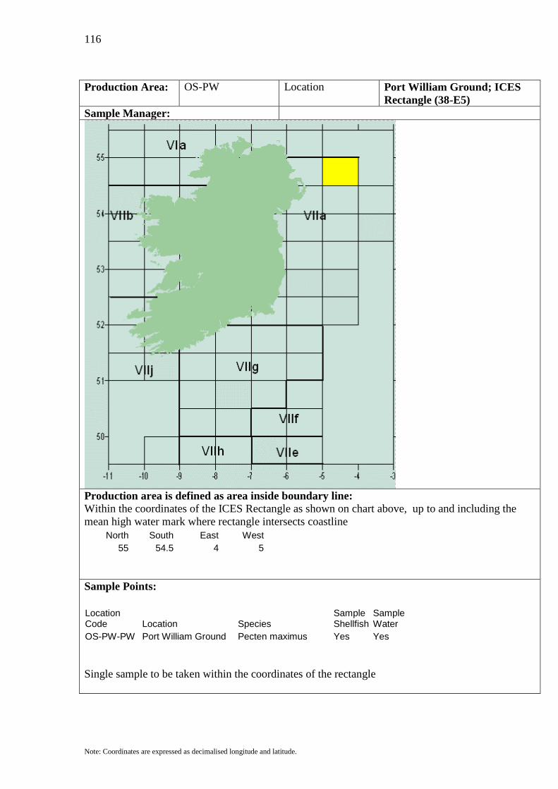
116
Note: Coordinates are expressed as decimalised longitude and latitude.
Production Area: OS-PW Location Port William Ground; ICES
Rectangle (38-E5) Sample Manager:
Production area is defined as area inside boundary line: Within the coordinates of the ICES Rectangle as shown on chart above, up to and including the mean high water mark where rectangle intersects coastline
North South East West 55 54.5 4 5
Sample Points:
Location Code Location Species
Sample Shellfish
Sample Water
OS-PW-PW Port William Ground Pecten maximus Yes Yes Single sample to be taken within the coordinates of the rectangle

117
Note: Coordinates are expressed as decimalised longitude and latitude.
Production Area: OS-BT Location Belmullet; ICES Rectangle (37-
D9) Sample Manager:
Production area is defined as area inside boundary line: Within the coordinates of the ICES Rectangle as shown on chart above, up to and including the mean high water mark where rectangle intersects coastline
North South East West 54.5 54 10 11
Sample Points:
Location Code Location Species
Sample Shellfish
Sample Water
OS-BT-BT Belmullet Pecten maximus Yes Yes Single sample to be taken within the coordinates of the rectangle

118
Note: Coordinates are expressed as decimalised longitude and latitude.
Production Area: OS-NK Location North of Killalla Bay; ICES
Rectangle (37-E0) Sample Manager:
Production area is defined as area inside boundary line: Within the coordinates of the ICES Rectangle as shown on chart above, up to and including the mean high water mark where rectangle intersects coastline
North South East West 54.5 54 9 10
Sample Points:
Location Code Location Species
Sample Shellfish
Sample Water
OS-NK-NK North of Killalla Bay Pecten maximus Yes Yes Single sample to be taken within the coordinates of the rectangle
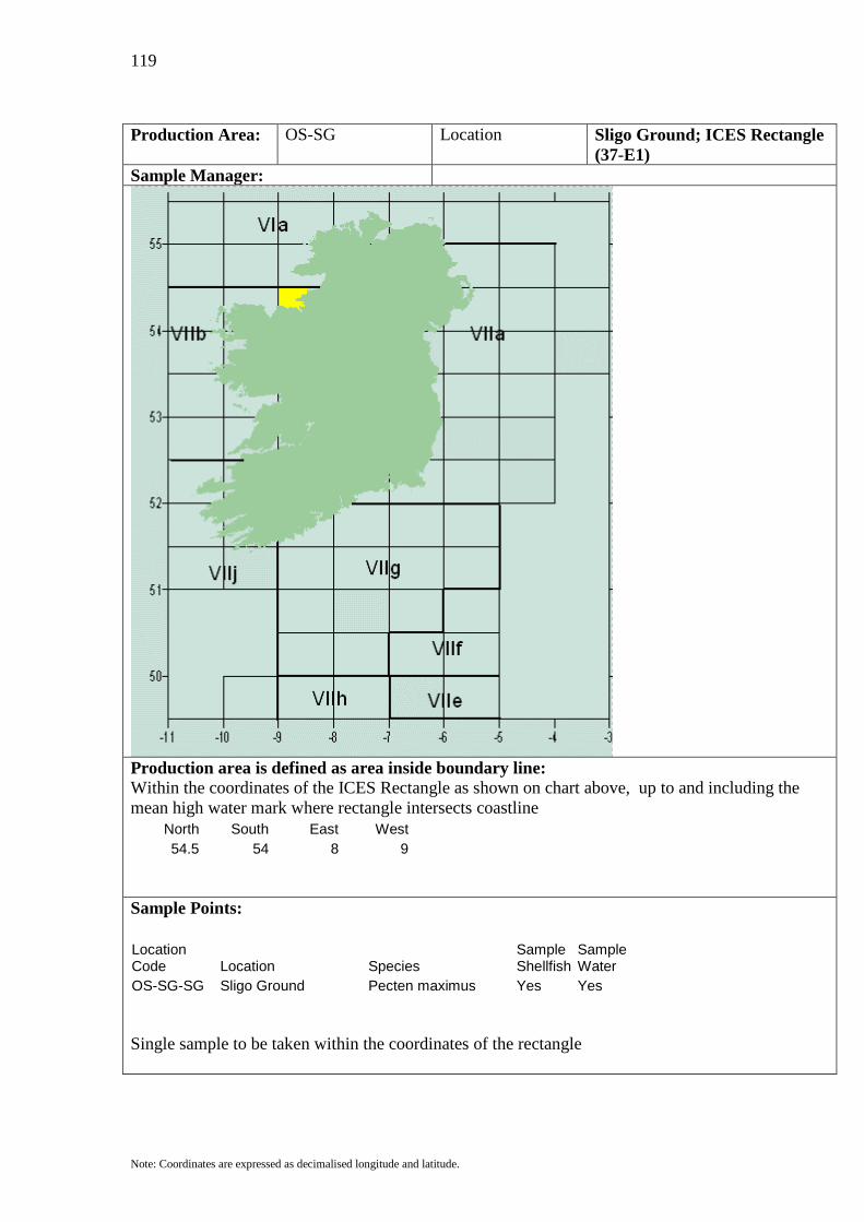
119
Note: Coordinates are expressed as decimalised longitude and latitude.
Production Area: OS-SG Location Sligo Ground; ICES Rectangle
(37-E1) Sample Manager:
Production area is defined as area inside boundary line: Within the coordinates of the ICES Rectangle as shown on chart above, up to and including the mean high water mark where rectangle intersects coastline
North South East West 54.5 54 8 9
Sample Points:
Location Code Location Species
Sample Shellfish
Sample Water
OS-SG-SG Sligo Ground Pecten maximus Yes Yes Single sample to be taken within the coordinates of the rectangle

120
Note: Coordinates are expressed as decimalised longitude and latitude.
Production Area: OS-AB Location Ardglass bank; ICES
Rectangle (37-E4) Sample Manager:
Production area is defined as area inside boundary line: Within the coordinates of the ICES Rectangle as shown on chart above, up to and including the mean high water mark where rectangle intersects coastline
North South East West 54.5 54 5 6
Sample Points:
Location Code Location Species
Sample Shellfish
Sample Water
OS-AB-AB Ardglass bank Pecten maximus Yes Yes Single sample to be taken within the coordinates of the rectangle

121
Note: Coordinates are expressed as decimalised longitude and latitude.
Production Area: OS-IM Location Isle of Man Ground; ICES
Rectangle (37-E5) Sample Manager:
Production area is defined as area inside boundary line: Within the coordinates of the ICES Rectangle as shown on chart above, up to and including the mean high water mark where rectangle intersects coastline
North South East West 54.5 54 4 5
Sample Points:
Location Code Location Species
Sample Shellfish
Sample Water
OS-IM-IM Isle of Man Ground Pecten maximus Yes Yes Single sample to be taken within the coordinates of the rectangle

122
Note: Coordinates are expressed as decimalised longitude and latitude.
Production Area: OS-EI Location East of Isle of Man; ICES
Rectangle (37-E6) Sample Manager:
Production area is defined as area inside boundary line: Within the coordinates of the ICES Rectangle as shown on chart above, up to and including the mean high water mark where rectangle intersects coastline
North South East West 54.5 54 3 4
Sample Points:
Location Code Location Species
Sample Shellfish
Sample Water
OS-EI-EI East of Isle of Man Pecten maximus Yes Yes Single sample to be taken within the coordinates of the rectangle

123
Note: Coordinates are expressed as decimalised longitude and latitude.
Production Area: OS-WC Location West of Clew Bay; ICES
Rectangle (36-D9) Sample Manager:
Production area is defined as area inside boundary line: Within the coordinates of the ICES Rectangle as shown on chart above, up to and including the mean high water mark where rectangle intersects coastline
North South East West 54 53.5 10 11
Sample Points:
Location Code Location Species
Sample Shellfish
Sample Water
OS-WC-WC West of Clew Bay Pecten maximus Yes Yes Single sample to be taken within the coordinates of the rectangle

124
Note: Coordinates are expressed as decimalised longitude and latitude.
Production Area: OS-CG Location Clogherhead Ground; ICES
Rectangle (36-E3) Sample Manager:
Production area is defined as area inside boundary line: Within the coordinates of the ICES Rectangle as shown on chart above, up to and including the mean high water mark where rectangle intersects coastline
North South East West 54 53.5 6 7
Sample Points:
Location Code Location Species
Sample Shellfish
Sample Water
OS-CG-CG Clogherhead Ground Pecten maximus Yes Yes Single sample to be taken within the coordinates of the rectangle

125
Note: Coordinates are expressed as decimalised longitude and latitude.
Production Area: OS-EC Location East of Clogherhead Groun;
ICES Rectangle (36-E4) Sample Manager:
Production area is defined as area inside boundary line: Within the coordinates of the ICES Rectangle as shown on chart above, up to and including the mean high water mark where rectangle intersects coastline
North South East West 54 53.5 5 6
Sample Points:
Location Code Location Species
Sample Shellfish
Sample Water
OS-EC-EC East of Clogherhead Ground Pecten maximus Yes Yes
Single sample to be taken within the coordinates of the rectangle

126
Note: Coordinates are expressed as decimalised longitude and latitude.
Production Area: OS-SI Location South of Isle of Man; ICES
Rectangle (36-E5) Sample Manager:
Production area is defined as area inside boundary line: Within the coordinates of the ICES Rectangle as shown on chart above, up to and including the mean high water mark where rectangle intersects coastline
North South East West 54 53.5 4 5
Sample Points:
Location Code Location Species
Sample Shellfish
Sample Water
OS-SI-SI South of Isle of Man Pecten maximus Yes Yes Single sample to be taken within the coordinates of the rectangle

127
Note: Coordinates are expressed as decimalised longitude and latitude.
Production Area: OS-MB Location Morecambe Bay; ICES
Rectangle (36-E6) Sample Manager:
Production area is defined as area inside boundary line: Within the coordinates of the ICES Rectangle as shown on chart above, up to and including the mean high water mark where rectangle intersects coastline
North South East West 54 53.5 3 4
Sample Points:
Location Code Location Species
Sample Shellfish
Sample Water
OS-MB-MB Morecambe Bay Pecten maximus Yes Yes Single sample to be taken within the coordinates of the rectangle

128
Note: Coordinates are expressed as decimalised longitude and latitude.
Production Area: OS-WG Location West of Galway Bay; ICES
Rectangle (35-D9) Sample Manager:
Production area is defined as area inside boundary line: Within the coordinates of the ICES Rectangle as shown on chart above, up to and including the mean high water mark where rectangle intersects coastline
North South East West 52.5 53 10 11
Sample Points:
Location Code Location Species
Sample Shellfish
Sample Water
OS-WG-WG West of Galway Bay Pecten maximus Yes Yes Single sample to be taken within the coordinates of the rectangle

129
Note: Coordinates are expressed as decimalised longitude and latitude.
Production Area: OS-GB Location Galway Bay Ground; ICES
Rectangle (35-E0) Sample Manager:
Production area is defined as area inside boundary line: Within the coordinates of the ICES Rectangle as shown on chart above, up to and including the mean high water mark where rectangle intersects coastline
North South East West 53.5 53 9 10
Sample Points:
Location Code Location Species
Sample Shellfish
Sample Water
OS-GB-GB Galway Bay Ground Pecten maximus Yes Yes Single sample to be taken within the coordinates of the rectangle

130
Note: Coordinates are expressed as decimalised longitude and latitude.
Production Area: OS-DE Location Dunlaoghaire Ground; ICES
Rectangle (35-E3) Sample Manager:
Production area is defined as area inside boundary line: Within the coordinates of the ICES Rectangle as shown on chart above, up to and including the mean high water mark where rectangle intersects coastline
North South East West 53.5 53 6 7
Sample Points:
Location Code Location Species
Sample Shellfish
Sample Water
OS-DE-DE Dunlaoghaire Ground Pecten maximus Yes Yes Single sample to be taken within the coordinates of the rectangle

131
Note: Coordinates are expressed as decimalised longitude and latitude.
Production Area: OS-ED Location East of Dunlaoghaire Ground;
ICES Rectangle (35-E4) Sample Manager:
Production area is defined as area inside boundary line: Within the coordinates of the ICES Rectangle as shown on chart above, up to and including the mean high water mark where rectangle intersects coastline
North South East West 53.5 53 5 6
Sample Points:
Location Code Location Species
Sample Shellfish
Sample Water
OS-ED-ED East of Dunlaoghaire Ground Pecten maximus Yes Yes
Single sample to be taken within the coordinates of the rectangle

132
Note: Coordinates are expressed as decimalised longitude and latitude.
Production Area: OS-AG Location Anglesey Ground; ICES
Rectangle (35-E5) Sample Manager:
Production area is defined as area inside boundary line: Within the coordinates of the ICES Rectangle as shown on chart above, up to and including the mean high water mark where rectangle intersects coastline
North South East West 53.5 53 4 5
Sample Points:
Location Code Location Species
Sample Shellfish
Sample Water
OS-AG-AG Anglesey Ground Pecten maximus Yes Yes Single sample to be taken within the coordinates of the rectangle
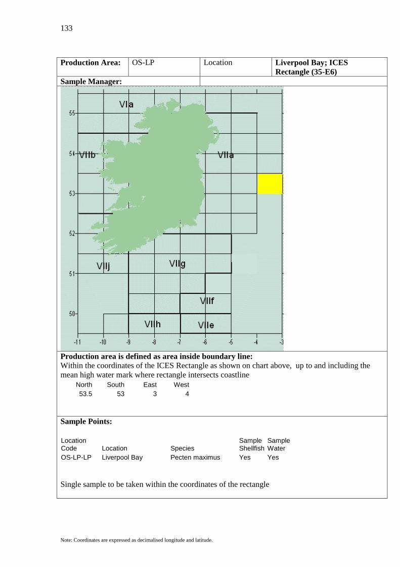
133
Note: Coordinates are expressed as decimalised longitude and latitude.
Production Area: OS-LP Location Liverpool Bay; ICES
Rectangle (35-E6) Sample Manager:
Production area is defined as area inside boundary line: Within the coordinates of the ICES Rectangle as shown on chart above, up to and including the mean high water mark where rectangle intersects coastline
North South East West 53.5 53 3 4
Sample Points:
Location Code Location Species
Sample Shellfish
Sample Water
OS-LP-LP Liverpool Bay Pecten maximus Yes Yes Single sample to be taken within the coordinates of the rectangle

134
Note: Coordinates are expressed as decimalised longitude and latitude.
Production Area: OS-WL Location West of Loop Head; ICES
Rectangle (34-D9) Sample Manager:
Production area is defined as area inside boundary line: Within the coordinates of the ICES Rectangle as shown on chart above, up to and including the mean high water mark where rectangle intersects coastline
North South East West 53 52.5 10 11
Sample Points:
Location Code Location Species
Sample Shellfish
Sample Water
OS-WL-WL West of Loop Head Pecten maximus Yes Yes Single sample to be taken within the coordinates of the rectangle

135
Note: Coordinates are expressed as decimalised longitude and latitude.
Production Area: OS-LH Location Loop Head Ground; ICES
Rectangle (34-E0) Sample Manager:
Production area is defined as area inside boundary line: Within the coordinates of the ICES Rectangle as shown on chart above, up to and including the mean high water mark where rectangle intersects coastline
North South East West 53 52.5 9 10
Sample Points:
Location Code Location Species
Sample Shellfish
Sample Water
OS-LH-LH Loop Head Ground Pecten maximus Yes Yes Single sample to be taken within the coordinates of the rectangle

136
Note: Coordinates are expressed as decimalised longitude and latitude.
Production Area: OS-AW Location Arklow Ground; ICES
Rectangle (34-E3) Sample Manager:
Production area is defined as area inside boundary line: Within the coordinates of the ICES Rectangle as shown on chart above, up to and including the mean high water mark where rectangle intersects coastline
North South East West 53 52.5 6 7
Sample Points:
Location Code Location Species
Sample Shellfish
Sample Water
OS-AW-AW Arklow Ground Pecten maximus Yes Yes Single sample to be taken within the coordinates of the rectangle
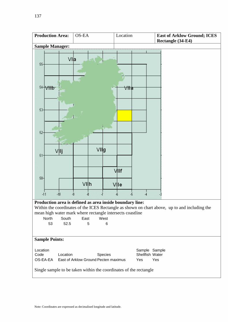
137
Note: Coordinates are expressed as decimalised longitude and latitude.
Production Area: OS-EA Location East of Arklow Ground; ICES
Rectangle (34-E4) Sample Manager:
Production area is defined as area inside boundary line: Within the coordinates of the ICES Rectangle as shown on chart above, up to and including the mean high water mark where rectangle intersects coastline
North South East West 53 52.5 5 6
Sample Points:
Location Code Location Species
Sample Shellfish
Sample Water
OS-EA-EA East of Arklow Ground Pecten maximus Yes Yes Single sample to be taken within the coordinates of the rectangle

138
Note: Coordinates are expressed as decimalised longitude and latitude.
Production Area: OS-DT Location Devil's Tail Ground; ICES
Rectangle (34-E5) Sample Manager:
Production area is defined as area inside boundary line: Within the coordinates of the ICES Rectangle as shown on chart above, up to and including the mean high water mark where rectangle intersects coastline
North South East West 53 52.5 4 5
Sample Points:
Location Code Location Species
Sample Shellfish
Sample Water
OS-DT-DT Devil's Tail Ground Pecten maximus Yes Yes Single sample to be taken within the coordinates of the rectangle
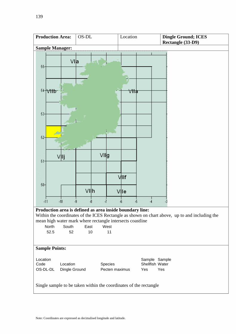
139
Note: Coordinates are expressed as decimalised longitude and latitude.
Production Area: OS-DL Location Dingle Ground; ICES
Rectangle (33-D9) Sample Manager:
Production area is defined as area inside boundary line: Within the coordinates of the ICES Rectangle as shown on chart above, up to and including the mean high water mark where rectangle intersects coastline
North South East West 52.5 52 10 11
Sample Points:
Location Code Location Species
Sample Shellfish
Sample Water
OS-DL-DL Dingle Ground Pecten maximus Yes Yes Single sample to be taken within the coordinates of the rectangle
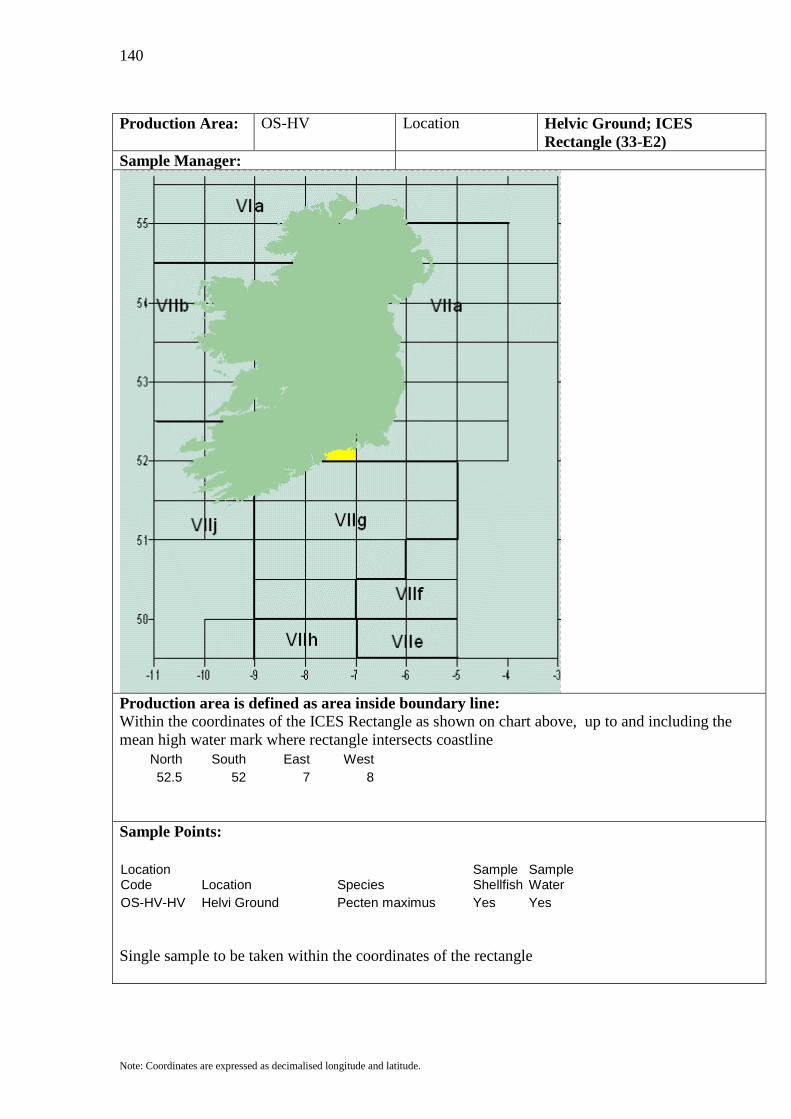
140
Note: Coordinates are expressed as decimalised longitude and latitude.
Production Area: OS-HV Location Helvic Ground; ICES
Rectangle (33-E2) Sample Manager:
Production area is defined as area inside boundary line: Within the coordinates of the ICES Rectangle as shown on chart above, up to and including the mean high water mark where rectangle intersects coastline
North South East West 52.5 52 7 8
Sample Points:
Location Code Location Species
Sample Shellfish
Sample Water
OS-HV-HV Helvi Ground Pecten maximus Yes Yes Single sample to be taken within the coordinates of the rectangle
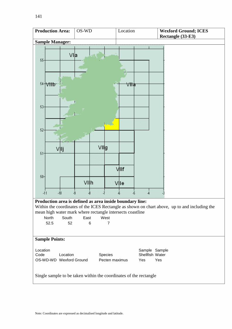
141
Note: Coordinates are expressed as decimalised longitude and latitude.
Production Area: OS-WD Location Wexford Ground; ICES Rectangle (33-E3)
Sample Manager:
Production area is defined as area inside boundary line: Within the coordinates of the ICES Rectangle as shown on chart above, up to and including the mean high water mark where rectangle intersects coastline
North South East West 52.5 52 6 7
Sample Points:
Location Code Location Species
Sample Shellfish
Sample Water
OS-WD-WD Wexford Ground Pecten maximus Yes Yes Single sample to be taken within the coordinates of the rectangle
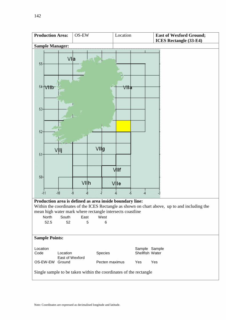
142
Note: Coordinates are expressed as decimalised longitude and latitude.
Production Area: OS-EW Location East of Wexford Ground;
ICES Rectangle (33-E4) Sample Manager:
Production area is defined as area inside boundary line: Within the coordinates of the ICES Rectangle as shown on chart above, up to and including the mean high water mark where rectangle intersects coastline
North South East West 52.5 52 5 6
Sample Points:
Location Code Location Species
Sample Shellfish
Sample Water
OS-EW-EW East of Wexford Ground Pecten maximus Yes Yes
Single sample to be taken within the coordinates of the rectangle

143
Note: Coordinates are expressed as decimalised longitude and latitude.
Production Area: OS-NQ Location New Quay Bay; ICES
Rectangle (33-E5) Sample Manager:
Production area is defined as area inside boundary line: Within the coordinates of the ICES Rectangle as shown on chart above, up to and including the mean high water mark where rectangle intersects coastline
North South East West 52.5 52 4 5
Sample Points:
Location Code Location Species
Sample Shellfish
Sample Water
OS-NQ-NQ New Quay Bay Pecten maximus Yes Yes Single sample to be taken within the coordinates of the rectangle

144
Note: Coordinates are expressed as decimalised longitude and latitude.
Production Area: OS-VG Location Valentia Ground; ICES
Rectangle (32-D9) Sample Manager:
Production area is defined as area inside boundary line: Within the coordinates of the ICES Rectangle as shown on chart above, up to and including the mean high water mark where rectangle intersects coastline
North South East West 52 51.5 10 11
Sample Points:
Location Code Location Species
Sample Shellfish
Sample Water
OS-VG-VG Valentia Ground Pecten maximus Yes Yes Single sample to be taken within the coordinates of the rectangle

145
Note: Coordinates are expressed as decimalised longitude and latitude.
Production Area: OS-KE Location Kinsale Ground; ICES
Rectangle (32-E1) Sample Manager:
Production area is defined as area inside boundary line: Within the coordinates of the ICES Rectangle as shown on chart above, up to and including the mean high water mark where rectangle intersects coastline
North South East West 52 51.5 8 9
Sample Points:
Location Code Location Species
Sample Shellfish
Sample Water
OS-KE-KE Kinsale Ground Pecten maximus Yes Yes Single sample to be taken within the coordinates of the rectangle

146
Note: Coordinates are expressed as decimalised longitude and latitude.
Production Area: OS-MH Location Mine Head Ground; ICES
Rectangle (32-E2) Sample Manager:
Production area is defined as area inside boundary line: Within the coordinates of the ICES Rectangle as shown on chart above, up to and including the mean high water mark where rectangle intersects coastline
North South East West 52 51.5 7 8
Sample Points:
Location Code Location Species
Sample Shellfish
Sample Water
OS-MH-MH Mine Head Ground Pecten maximus Yes Yes Single sample to be taken within the coordinates of the rectangle

147
Note: Coordinates are expressed as decimalised longitude and latitude.
Production Area: OS-SS Location Saltees Ground; ICES
Rectangle (32-E3) Sample Manager:
Production area is defined as area inside boundary line: Within the coordinates of the ICES Rectangle as shown on chart above, up to and including the mean high water mark where rectangle intersects coastline
North South East West 52 51.5 6 7
Sample Points:
Location Code Location Species
Sample Shellfish
Sample Water
OS-SS-SS Saltees Ground Pecten maximus Yes Yes Single sample to be taken within the coordinates of the rectangle

148
Note: Coordinates are expressed as decimalised longitude and latitude.
Production Area: OS-SD Location Smalls Ground; ICES
Rectangle (32-E4) Sample Manager:
Production area is defined as area inside boundary line: Within the coordinates of the ICES Rectangle as shown on chart above, up to and including the mean high water mark where rectangle intersects coastline
North South East West 52 51.5 5 6
Sample Points:
Location Code Location Species
Sample Shellfish
Sample Water
OS-SD-SS Smalls Ground Pecten maximus Yes Yes Single sample to be taken within the coordinates of the rectangle
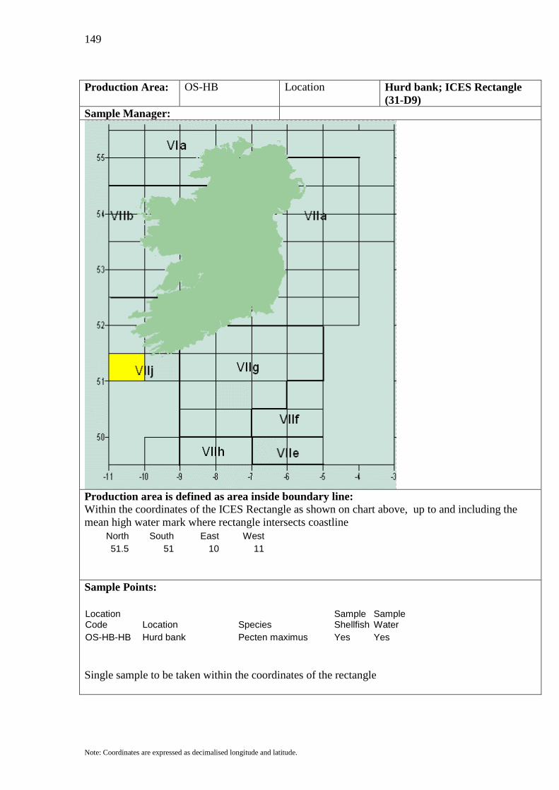
149
Note: Coordinates are expressed as decimalised longitude and latitude.
Production Area: OS-HB Location Hurd bank; ICES Rectangle
(31-D9) Sample Manager:
Production area is defined as area inside boundary line: Within the coordinates of the ICES Rectangle as shown on chart above, up to and including the mean high water mark where rectangle intersects coastline
North South East West 51.5 51 10 11
Sample Points:
Location Code Location Species
Sample Shellfish
Sample Water
OS-HB-HB Hurd bank Pecten maximus Yes Yes Single sample to be taken within the coordinates of the rectangle

150
Note: Coordinates are expressed as decimalised longitude and latitude.
Production Area: OS-FG Location Fastnet Ground; ICES
Rectangle (31-E0) Sample Manager:
Production area is defined as area inside boundary line: Within the coordinates of the ICES Rectangle as shown on chart above, up to and including the mean high water mark where rectangle intersects coastline
North South East West 51.5 51 9 10
Sample Points:
Location Code Location Species
Sample Shellfish
Sample Water
OS-FG-FG Fastnet Ground Pecten maximus Yes Yes Single sample to be taken within the coordinates of the rectangle

151
Note: Coordinates are expressed as decimalised longitude and latitude.
Production Area: OS-SK Location South of Kinsale Ground;
ICES Rectangle (31-E1) Sample Manager:
Production area is defined as area inside boundary line: Within the coordinates of the ICES Rectangle as shown on chart above, up to and including the mean high water mark where rectangle intersects coastline
North South East West 51.5 51 8 9
Sample Points:
Location Code Location Species
Sample Shellfish
Sample Water
OS-SK-SK South of Kinsale Ground Pecten maximus Yes Yes
Single sample to be taken within the coordinates of the rectangle

152
Note: Coordinates are expressed as decimalised longitude and latitude.
Production Area: OS-SM Location South of Mine Head Ground;
ICES Rectangle (31-E2) Sample Manager:
Production area is defined as area inside boundary line: Within the coordinates of the ICES Rectangle as shown on chart above, up to and including the mean high water mark where rectangle intersects coastline
North South East West 51.5 51 7 8
Sample Points:
Location Code Location Species
Sample Shellfish
Sample Water
OS-SM-SM South of Mine Head Ground Pecten maximus Yes Yes
Single sample to be taken within the coordinates of the rectangle

153
Note: Coordinates are expressed as decimalised longitude and latitude.
Production Area: OS-SL Location South of Smalls Ground; ICES
Rectangle (31-E3) Sample Manager:
Production area is defined as area inside boundary line: Within the coordinates of the ICES Rectangle as shown on chart above, up to and including the mean high water mark where rectangle intersects coastline
North South East West 51.5 51 6 7
Sample Points:
Location Code Location Species
Sample Shellfish
Sample Water
OS-SL-SL South of Smalls Ground Pecten maximus Yes Yes
Single sample to be taken within the coordinates of the rectangle

154
Note: Coordinates are expressed as decimalised longitude and latitude.
Production Area: OS-SB Location Stanley Bay; ICES Rectangle
(31-E4) Sample Manager:
Production area is defined as area inside boundary line: Within the coordinates of the ICES Rectangle as shown on chart above, up to and including the mean high water mark where rectangle intersects coastline
North South East West 51.5 51 5 6
Sample Points:
Location Code Location Species
Sample Shellfish
Sample Water
OS-SB-SB Stanley Bay Pecten maximus Yes Yes Single sample to be taken within the coordinates of the rectangle
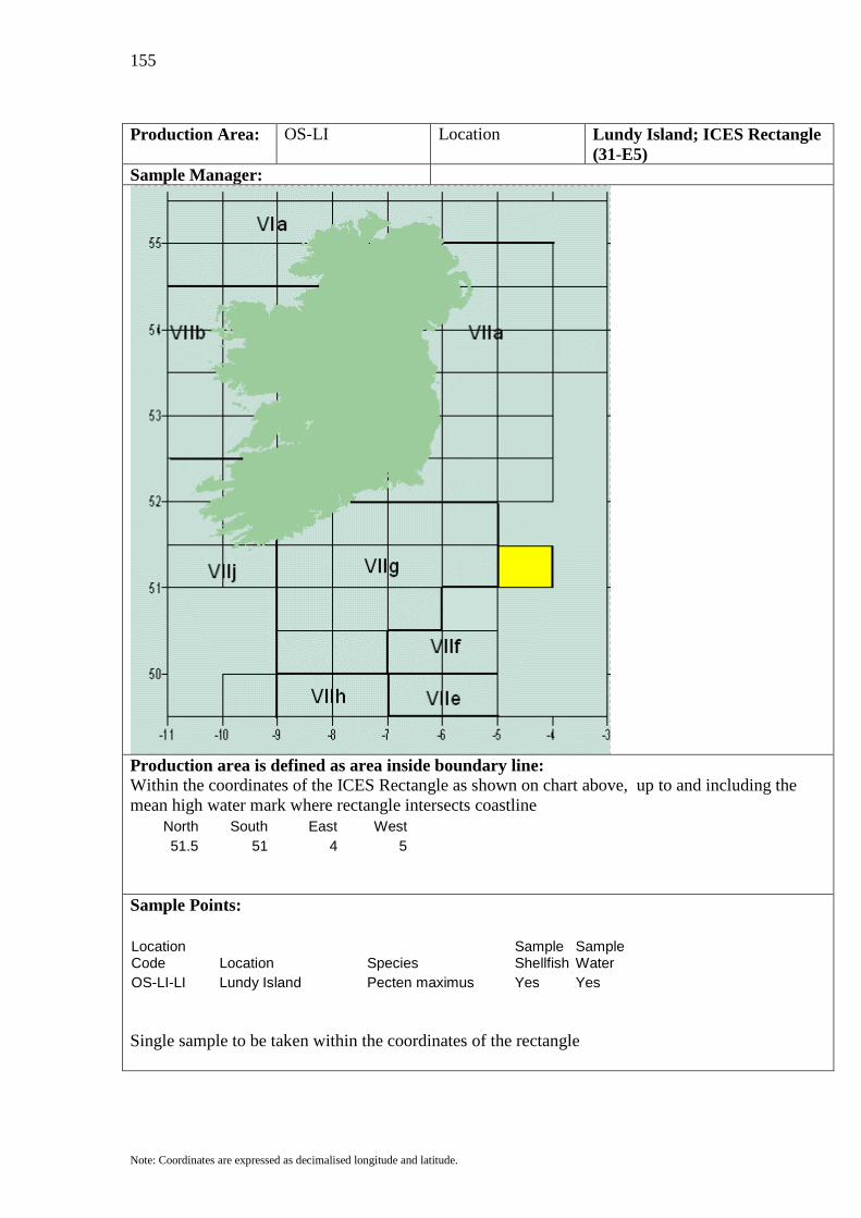
155
Note: Coordinates are expressed as decimalised longitude and latitude.
Production Area: OS-LI Location Lundy Island; ICES Rectangle
(31-E5) Sample Manager:
Production area is defined as area inside boundary line: Within the coordinates of the ICES Rectangle as shown on chart above, up to and including the mean high water mark where rectangle intersects coastline
North South East West 51.5 51 4 5
Sample Points:
Location Code Location Species
Sample Shellfish
Sample Water
OS-LI-LI Lundy Island Pecten maximus Yes Yes Single sample to be taken within the coordinates of the rectangle
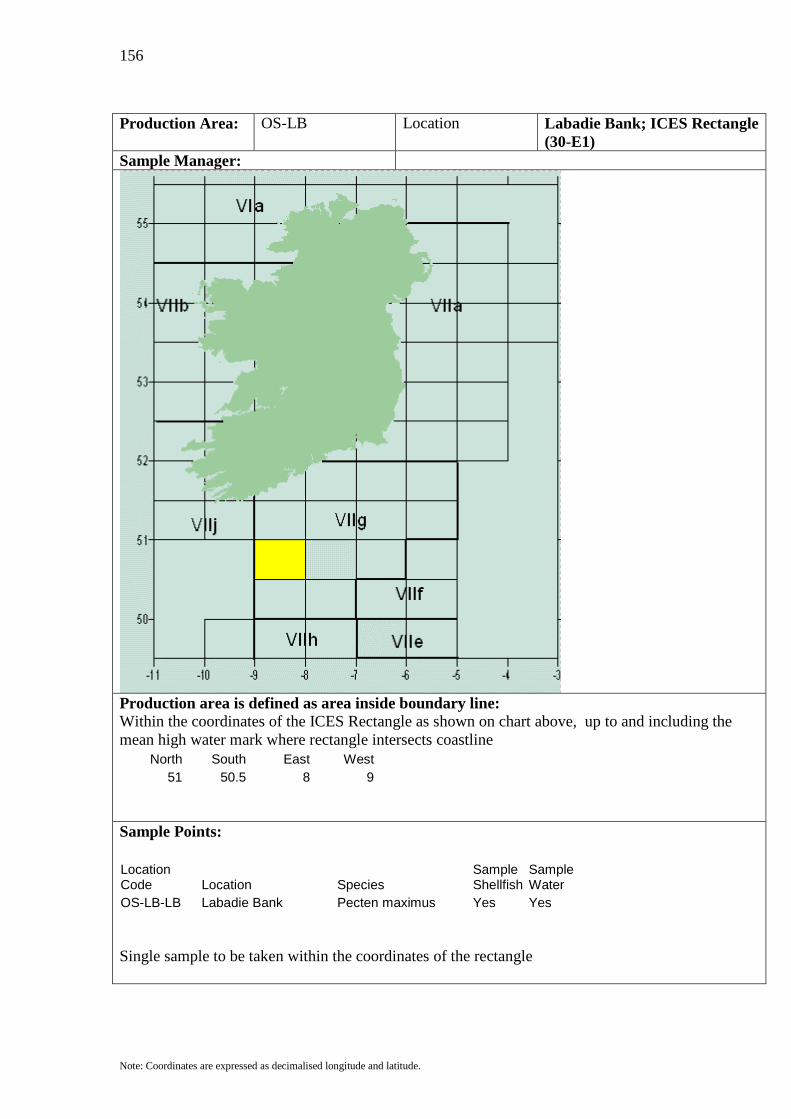
156
Note: Coordinates are expressed as decimalised longitude and latitude.
Production Area: OS-LB Location Labadie Bank; ICES Rectangle
(30-E1) Sample Manager:
Production area is defined as area inside boundary line: Within the coordinates of the ICES Rectangle as shown on chart above, up to and including the mean high water mark where rectangle intersects coastline
North South East West 51 50.5 8 9
Sample Points:
Location Code Location Species
Sample Shellfish
Sample Water
OS-LB-LB Labadie Bank Pecten maximus Yes Yes Single sample to be taken within the coordinates of the rectangle

157
Note: Coordinates are expressed as decimalised longitude and latitude.
Production Area: OS-EL Location East of Labadie Bank; ICES
Rectangle (30-E2) Sample Manager:
Production area is defined as area inside boundary line: Within the coordinates of the ICES Rectangle as shown on chart above, up to and including the mean high water mark where rectangle intersects coastline
North South East West 51 50.5 7 8
Sample Points:
Location Code Location Species
Sample Shellfish
Sample Water
OS-EL-EL East of Labadie Bank Pecten maximus Yes Yes Single sample to be taken within the coordinates of the rectangle

158
Note: Coordinates are expressed as decimalised longitude and latitude.
Production Area: OS-NN Location Northwest of Newlyn; ICES
Rectangle (30-E3) Sample Manager:
Production area is defined as area inside boundary line: Within the coordinates of the ICES Rectangle as shown on chart above, up to and including the mean high water mark where rectangle intersects coastline
North South East West 51 50.5 6 7
Sample Points:
Location Code Location Species
Sample Shellfish
Sample Water
OS-NN-NN Northwest of Newlyn Pecten maximus Yes Yes Single sample to be taken within the coordinates of the rectangle

159
Note: Coordinates are expressed as decimalised longitude and latitude.
Production Area: OS-NT Location North of Newlyn; ICES
Rectangle (30-E4) Sample Manager:
Production area is defined as area inside boundary line: Within the coordinates of the ICES Rectangle as shown on chart above, up to and including the mean high water mark where rectangle intersects coastline
North South East West 51 50.5 5 6
Sample Points:
Location Code Location Species
Sample Shellfish
Sample Water
OS-NT-NT North of Newlyn Pecten maximus Yes Yes Single sample to be taken within the coordinates of the rectangle

160
Note: Coordinates are expressed as decimalised longitude and latitude.
Production Area: OS-WB Location West Bank; ICES Rectangle
(29-E1) Sample Manager:
Production area is defined as area inside boundary line: Within the coordinates of the ICES Rectangle as shown on chart above, up to and including the mean high water mark where rectangle intersects coastline
North South East West 50.5 50 8 9
Sample Points:
Location Code Location Species
Sample Shellfish
Sample Water
OS-WB-WB West Bank Pecten maximus Yes Yes Single sample to be taken within the coordinates of the rectangle

161
Note: Coordinates are expressed as decimalised longitude and latitude.
Production Area: OS-NB Location Northwest Bank; ICES
Rectangle (29-E2) Sample Manager:
Production area is defined as area inside boundary line: Within the coordinates of the ICES Rectangle as shown on chart above, up to and including the mean high water mark where rectangle intersects coastline
North South East West 50.5 50 7 8
Sample Points:
Location Code Location Species
Sample Shellfish
Sample Water
OS-NB-NB Northwest Bank Pecten maximus Yes Yes Single sample to be taken within the coordinates of the rectangle

162
Note: Coordinates are expressed as decimalised longitude and latitude.
Production Area: OS-WN Location West of Newlyn; ICES
Rectangle (29-E3) Sample Manager:
Production area is defined as area inside boundary line: Within the coordinates of the ICES Rectangle as shown on chart above, up to and including the mean high water mark where rectangle intersects coastline
North South East West 50.5 50 6 7
Sample Points:
Location Code Location Species
Sample Shellfish
Sample Water
OS-WN-WN West of Newlyn Pecten maximus Yes Yes Single sample to be taken within the coordinates of the rectangle

163
Note: Coordinates are expressed as decimalised longitude and latitude.
Production Area: OS-NL Location Newlyn; ICES Rectangle (29-
E4) Sample Manager:
Production area is defined as area inside boundary line: Within the coordinates of the ICES Rectangle as shown on chart above, up to and including the mean high water mark where rectangle intersects coastline
North South East West 50.5 50 5 6
Sample Points:
Location Code Location Species
Sample Shellfish
Sample Water
OS-NL-NL Newlyn Pecten maximus Yes Yes Single sample to be taken within the coordinates of the rectangle

164
Note: Coordinates are expressed as decimalised longitude and latitude.
Production Area: OS-CB Location Cockburn Bank; ICES
Rectangle (28-E0) Sample Manager:
Production area is defined as area inside boundary line: Within the coordinates of the ICES Rectangle as shown on chart above, up to and including the mean high water mark where rectangle intersects coastline
North South East West 50 49.5 9 10
Sample Points:
Location Code Location Species
Sample Shellfish
Sample Water
OS-CB-CB Cockburn Bank Pecten maximus Yes Yes Single sample to be taken within the coordinates of the rectangle

165
Note: Coordinates are expressed as decimalised longitude and latitude.
Production Area: OS-WJ Location Western Jones Bank; ICES
Rectangle (28-E1) Sample Manager:
Production area is defined as area inside boundary line: Within the coordinates of the ICES Rectangle as shown on chart above, up to and including the mean high water mark where rectangle intersects coastline
North South East West 50 49.5 8 9
Sample Points:
Location Code Location Species
Sample Shellfish
Sample Water
OS-WJ-WJ Western Jones Bank Pecten maximus Yes Yes Single sample to be taken within the coordinates of the rectangle

166
Note: Coordinates are expressed as decimalised longitude and latitude.
Production Area: OS-EJ Location Eastern Jones Bank; ICES
Rectangle (28-E2) Sample Manager:
Production area is defined as area inside boundary line: Within the coordinates of the ICES Rectangle as shown on chart above, up to and including the mean high water mark where rectangle intersects coastline
North South East West 50 49.5 7 8
Sample Points:
Location Code Location Species
Sample Shellfish
Sample Water
OS-EJ-EJ Eastern Jones Bank Pecten maximus Yes Yes Single sample to be taken within the coordinates of the rectangle
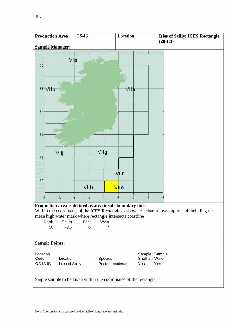
167
Note: Coordinates are expressed as decimalised longitude and latitude.
Production Area: OS-IS Location Isles of Scilly; ICES Rectangle
(28-E3) Sample Manager:
Production area is defined as area inside boundary line: Within the coordinates of the ICES Rectangle as shown on chart above, up to and including the mean high water mark where rectangle intersects coastline
North South East West 50 49.5 6 7
Sample Points:
Location Code Location Species
Sample Shellfish
Sample Water
OS-IS-IS Isles of Scilly Pecten maximus Yes Yes Single sample to be taken within the coordinates of the rectangle

168
Note: Coordinates are expressed as decimalised longitude and latitude.
Production Area: OS-SN Location South of Newlyn ICES
Rectangle (28-E4) Sample Manager:
Production area is defined as area inside boundary line: Within the coordinates of the ICES Rectangle as shown on chart above, up to and including the mean high water mark where rectangle intersects coastline
North South East West 50 49.5 5 6
Sample Points:
Location Code Location Species
Sample Shellfish
Sample Water
OS-SN-SN South of Newlyn Pecten maximus Yes Yes Single sample to be taken within the coordinates of the rectangle
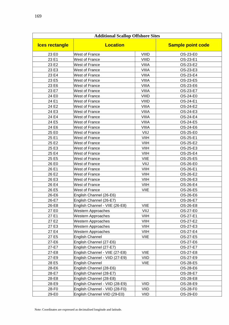
169
Note: Coordinates are expressed as decimalised longitude and latitude.
Additional Scallop Offshore Sites
Ices rectangle Location Sample point code
23 E0 West of France VIIID OS-23-E0 23 E1 West of France VIIID OS-23-E1 23 E2 West of France VIIIA OS-23-E2 23 E3 West of France VIIIA OS-23-E3 23 E4 West of France VIIIA OS-23-E4 23 E5 West of France VIIIA OS-23-E5 23 E6 West of France VIIIA OS-23-E6 23 E7 West of France VIIIA OS-23-E7 24 E0 West of France VIIID OS-24-E0 24 E1 West of France VIIID OS-24-E1 24 E2 West of France VIIIA OS-24-E2 24 E3 West of France VIIIA OS-24-E3 24 E4 West of France VIIIA OS-24-E4 24 E5 West of France VIIIA OS-24-E5 24 E6 West of France VIIIA OS-24-E6 25 E0 West of France VIIJ OS-25-E0 25 E1 West of France VIIH OS-25-E1 25 E2 West of France VIIH OS-25-E2 25 E3 West of France VIIH OS-25-E3 25 E4 West of France VIIH OS-25-E4 25 E5 West of France VIIE OS-25-E5 26 E0 West of France VIIJ OS-26-E0 26 E1 West of France VIIH OS-26-E1 26 E2 West of France VIIH OS-26-E2 26 E3 West of France VIIH OS-26-E3 26 E4 West of France VIIH OS-26-E4 26 E5 West of France VIIE OS-26-E5 26-E6 English Channel (26-E6) OS-26-E6 26-E7 English Channel (26-E7) OS-26-E7 26-E8 English Channel - VIIE (26-E8) VIIE OS-26-E8 27 E0 Western Approaches VIIJ OS-27-E0 27 E1 Western Approaches VIIH OS-27-E1 27 E2 Western Approaches VIIH OS-27-E2 27 E3 Western Approaches VIIH OS-27-E3 27 E4 Western Approaches VIIH OS-27-E4 27 E5 English Channel VIIE OS-27-E5 27-E6 English Channel (27-E6) OS-27-E6 27-E7 English Channel (27-E7) OS-27-E7 27-E8 English Channel - VIIE (27-E8) VIIE OS-27-E8 27-E9 English Channel - VIID (27-E9) VIID OS-27-E9 28 E5 English Channel VIIE OS-28-E5 28-E6 English Channel (28-E6) OS-28-E6 28-E7 English Channel (28-E7) OS-28-E7 28-E8 English Channel (28-E8) OS-28-E8 28-E9 English Channel - VIID (28-E9) VIID OS-28-E9 28-F0 English Channel - VIID (28-F0) VIID OS-28-F0 29-E0 English Channel VIID (29-E0) VIID OS-29-E0
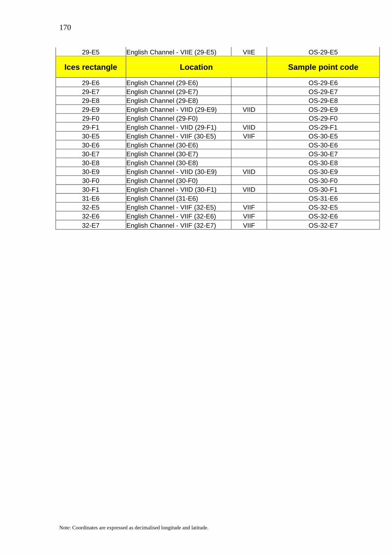
170
Note: Coordinates are expressed as decimalised longitude and latitude.
29-E5 English Channel - VIIE (29-E5) VIIE OS-29-E5
Ices rectangle Location Sample point code
29-E6 English Channel (29-E6) OS-29-E6 29-E7 English Channel (29-E7) OS-29-E7 29-E8 English Channel (29-E8) OS-29-E8 29-E9 English Channel - VIID (29-E9) VIID OS-29-E9 29-F0 English Channel (29-F0) OS-29-F0 29-F1 English Channel - VIID (29-F1) VIID OS-29-F1 30-E5 English Channel - VIIF (30-E5) VIIF OS-30-E5 30-E6 English Channel (30-E6) OS-30-E6 30-E7 English Channel (30-E7) OS-30-E7 30-E8 English Channel (30-E8) OS-30-E8 30-E9 English Channel - VIID (30-E9) VIID OS-30-E9 30-F0 English Channel (30-F0) OS-30-F0 30-F1 English Channel - VIID (30-F1) VIID OS-30-F1 31-E6 English Channel (31-E6) OS-31-E6 32-E5 English Channel - VIIF (32-E5) VIIF OS-32-E5 32-E6 English Channel - VIIF (32-E6) VIIF OS-32-E6 32-E7 English Channel - VIIF (32-E7) VIIF OS-32-E7