Mobile Phones as Ubiquitous Social and … Phones as Ubiquitous Social and Environmental Geo-Sensors...
20
1 Mobile Phones as Ubiquitous Social and Environmental Geo-Sensors Günther Sagl, Bernd Resch Chair of Geoinformatics, Department of Geography, Heidelberg University, Germany ABSTRACT Mobile and sensor-rich devices such as today’s smartphones are increasingly leveraged as ubiquitous mobile sensors that are able to sense their immediate surroundings on site in high spatial and temporal detail. Using those devices, the activity or mobility behavior of mobile phone users is being “sensed” since they leave behind digital traces of their whereabouts when using the mobile network – voluntarily or not. Additionally, people themselves can act as human sensors by providing subjective, geo-referenced “observations” in the form of individual perceptions of, e.g., the weather, thereby complementing calibrated measurements from technical geo-sensor networks. Together with other user-generated and increasingly geo-referenced data and information from a variety of Web 2.0 and social media platforms, this results in vast volumes of data that digitally reflect the dynamics of human behavior (e.g., mobility in urban spaces) and environmental phenomena (e.g., the weather). In this chapter we provide an overview of recent literature, influencing scholars, and future research directions in the context of investigating human and environmental dynamics using mobile phones as ubiquitous sensors. INTRODUCTION Mobile communication networks have been designed to allow people to communicate wirelessly almost everywhere at all times. Particularly in urban environments such networks are ubiquitous, and thus the mobile communication services they offer. Moreover, communication networks can be seen as higher-level large-scale human behavior sensors (Shoval, 2007), which include in fact hundreds of thousands of mobile in situ geo-sensing components, i.e., the mobile phones carried by their users. The term “in situ”, in contrast to “remote”, means that the sensor is very close to, or in direct contact with the phenomenon being sensed, for instance data from a sensor at a weather station sensing the air temperature is an example of environmental in situ sensor data, or a mobile phone carried by a person “sensing” their activity and mobility. In other words, the user- generated traffic within mobile networks, as well as the geo-referenced social media data published by individuals, can serve as a proxy for the collective human behavior; such data are referred herein to as social in situ sensor data. Today, smartphones are sensor-rich devices, which are increasingly leveraged as ubiquitous mobile sensors (Khan et al., 2013; Lane et al., 2010) that are able to sense their immediate surroundings on site in high spatial and temporal detail. In fact, people themselves can act as human sensors and provide subjective “observations” in the form of individual perceptions. Such perceptions are increasingly shared by people voluntarily as geographic information on diverse Web 2.0 and social media platforms (e.g., geo-tagged pictures and text on Twitter, Instagram, etc.) via their mobile phones and a mobile network. Such human sensor data can complement calibrated electronic sensor measurements from geo-sensor networks, e.g., for environmental monitoring.
Transcript of Mobile Phones as Ubiquitous Social and … Phones as Ubiquitous Social and Environmental Geo-Sensors...
1
Mobile Phones as Ubiquitous Social
and Environmental Geo-Sensors Günther Sagl, Bernd Resch
Chair of Geoinformatics, Department of Geography, Heidelberg University, Germany
ABSTRACT Mobile and sensor-rich devices such as today’s smartphones are increasingly leveraged as
ubiquitous mobile sensors that are able to sense their immediate surroundings on site in high
spatial and temporal detail. Using those devices, the activity or mobility behavior of mobile
phone users is being “sensed” since they leave behind digital traces of their whereabouts when
using the mobile network – voluntarily or not. Additionally, people themselves can act as human
sensors by providing subjective, geo-referenced “observations” in the form of individual
perceptions of, e.g., the weather, thereby complementing calibrated measurements from technical
geo-sensor networks. Together with other user-generated and increasingly geo-referenced data
and information from a variety of Web 2.0 and social media platforms, this results in vast
volumes of data that digitally reflect the dynamics of human behavior (e.g., mobility in urban
spaces) and environmental phenomena (e.g., the weather). In this chapter we provide an overview
of recent literature, influencing scholars, and future research directions in the context of
investigating human and environmental dynamics using mobile phones as ubiquitous sensors.
INTRODUCTION
Mobile communication networks have been designed to allow people to communicate wirelessly
almost everywhere at all times. Particularly in urban environments such networks are ubiquitous,
and thus the mobile communication services they offer. Moreover, communication networks can
be seen as higher-level large-scale human behavior sensors (Shoval, 2007), which include in fact
hundreds of thousands of mobile in situ geo-sensing components, i.e., the mobile phones carried
by their users. The term “in situ”, in contrast to “remote”, means that the sensor is very close to,
or in direct contact with the phenomenon being sensed, for instance data from a sensor at a
weather station sensing the air temperature is an example of environmental in situ sensor data, or
a mobile phone carried by a person “sensing” their activity and mobility. In other words, the user-
generated traffic within mobile networks, as well as the geo-referenced social media data
published by individuals, can serve as a proxy for the collective human behavior; such data are
referred herein to as social in situ sensor data.
Today, smartphones are sensor-rich devices, which are increasingly leveraged as ubiquitous
mobile sensors (Khan et al., 2013; Lane et al., 2010) that are able to sense their immediate
surroundings on site in high spatial and temporal detail. In fact, people themselves can act as
human sensors and provide subjective “observations” in the form of individual perceptions. Such
perceptions are increasingly shared by people voluntarily as geographic information on diverse
Web 2.0 and social media platforms (e.g., geo-tagged pictures and text on Twitter, Instagram, etc.)
via their mobile phones and a mobile network. Such human sensor data can complement
calibrated electronic sensor measurements from geo-sensor networks, e.g., for environmental
monitoring.
2
The resulting vast volumes of such social and environmental in situ sensor data digitally reflect,
to some degree, the spatial and temporal dynamics of human behavior (e.g., large-scale activity
and mobility in urban spaces) and environmental phenomena (e.g., objective measures or
subjective perceptions of weather conditions). Furthermore, the consolidation of these data, which
are highly diverse by nature, on a common space-time basis enables further analyses. The results
of such analyses can potentially shed new light on local and short-term environment-human
interface aspects, for instance, the relationships between weather conditions and collective human
behavior.
In this chapter, we make an attempt to demonstrate the use of mobile phones as ubiquitous mobile
in situ geo-sensors for investigating human and environmental dynamics and potential human-
environmental relationships. Since such dynamics inherently comprise both a temporal and a geo-
spatial component, we herein underpin the added value of integrating interdisciplinary methods
linked with Geographic Information Science theory and Applied Geoinformatics.
In the following sections we start with providing a brief overview of the intellectual history in
that research area including influencing scholars and institutions. In the main part we elaborate
on the current scientific knowledge of three concrete research areas: human-centered data
acquisition, space-time patterns of human behavior, and relationships of human behavior in the
environmental context. Finally, we provide a conclusion and future research directions related to
the overarching context of investigating human and environmental dynamics based on diverse
human and technical sensor data.
OVERVIEW OF THE INTELLECTUAL HISTORY
In this chapter, we put emphasis on the geo-spatial and temporal components of mobile phone
data acquisition and data analysis. We focus on the following three concrete research areas:
- Human-centered data acquisition using mobile phones
- Space-time patterns of human behavior derived from mobile phone data
- Exploring human behavior in the environmental context
As a result from deficient data availability and the fast rise of smartphone penetration, new
human-centered approaches for data acquisition are currently investigated. The interaction
with social media such as Twitter, Instagram, Facebook, etc. is increasingly happening on mobile
devices (Perreault & Ruths, 2011), thereby generating vast amounts of Volunteered Geographic
Information (VGI) (Goodchild, 2009; Goodchild, 2007a). Data from mobile networks and social
media thus reflect, to some degree, the dynamics in social environments. Additionally, the
concept of “People as Sensors” (Resch, 2013) allows people to share their individual perceptions
as subjective “measurements” of, e.g., air quality, the weather, or even their situational emotional
feeling via their mobile phones. Like this, the gathered observations complement measurements
from technical sensor networks. This is also underpinned by Sarah Elwood, who discusses
societal implications of neogeography and the “geo-spatial web” and tries to define future
research avenues through an extensive review of early literature in the field (Elwood, 2008a,
2008b, 2010).
Research in the field of urban social dynamics and human behavior patterns based on mobile
phone data has been intensively conducted by the MIT’s SENSEable City Lab, Boston (USA),
and partner institutions, with several pioneering and currently leading scholars (Calabrese et al.,
2013; Calabrese et al., 2011c; Di Lorenzo & Calabrese, 2011; Krings et al., 2009; Quercia, 2010;
Ratti et al., 2006; Ratti et al., 2007; Ratti et al., 2010). Recent examples of urban social dynamics
3
and human behavior patterns are shown in Real-Time Rome (Calabrese et al., 2011a) or LIVE
Singapore! (Kloeckl et al., 2012). In the domain of formal mathematical modeling, i.e., deriving
general laws of human behavior from vast volumes of mobile phone data, the most influencing
scholars are, e.g., Barabasi (2005), González and Barabási (2007), Onnela et al. (2007), González
et al. (2008), Candia et al. (2008), Simini et al. (2012). One important geographic location for that
pioneering research is the Center for Complex Network Research (CCNR), Northeastern
University, Boston (USA).
Understanding the complex interface between the environment and humans and the
interactions’ inherent dynamics is a multidisciplinary challenge. Herein we summarize recent
approaches that explore human-environment interactions based on social and environmental
sensor data. We focus on the spatial and temporal components of the underlying, typically
geographic phenomenon. Since such approaches are rarely documented in scientific literature yet,
it is difficult to name influencing scholars or institutions. From a more global and long-term
perspective, the environmental and climatic context has certain associations to large-scale human
behavior. For instance, researchers have explored the association of El Niño/Southern Oscillation
(ENSO) with civil conflicts (Hsiang et al., 2011), or climate change with large-scale mobility and
migration (McLeman & Hunter, 2010; Tacoli, 2009). In contrast to these temporal and spatial
scale levels, we focus on the operational scale of a city. We demonstrate how ubiquitous
technologies such as the mobile phone network and advanced sensing methods, which are needed
for information extraction (Hancke et al., 2013), can support this purpose. Furthermore, based
such human and technical sensor data, we show examples on how novel analysis methods can be
used explore the collective behavior of people in diverse contexts such as the weather.
CURRENT SCIENTIFIC KNOWLEDGE
Following the brief overview of intellectual history, we highlight the use of mobile phones as
ubiquitous sensors for investigating human and environmental dynamics. We start with
innovative concepts and methods for human-centered data acquisition using mobile phones. Then,
we illustrate several spatio-temporal human behavior patterns derived from mobile phone usage.
The final sub-section focuses on exploring some aspects of the environment-human interface and
its interactions in both space and time based on mobile phone data and weather data. These three
areas are addressed from a Geographic Information Science / Geoinformatics perspective.
Human-centered Data Acquisition using Mobile Phones
It has been widely proven that ubiquitous sensor networks can assist in taking decisions in near
real-time in a variety of application areas such as public safety, traffic management,
environmental monitoring or in public health (Resch et al., 2010a; Sneha & Varshney, 2009) Yet,
analyzing and monitoring our surroundings in near real-time is still a major challenge due to
sparsely available data sources. As a result from this deficiency, coupled with the fast rise of
mobile phones, a number of researchers have started to investigate alternative methods for
generating real-time data relevant for decision-making processes. Recent efforts have been taken
by OpenSignal (Overeem et al., 2013). On Line Disaster Response Community (Laituri &
Kodrich, 2008), CenceMe (Miluzzo et al., 2008) or Near Future Laboratory (Girardin et al., 2008).
In scientific literature, we see a number of human-centered sensing approaches that can be
summarized in three main concepts: People as Sensors, Collective Sensing and Citizen Science.
This sub-section presents a clear disambiguation between these concepts.
People as Sensors defines a sensing model, in which measurements are not only taken by
calibrated hardware sensors, but in which also humans can contribute their subjective
“measurements” such as their individual sensations, current perceptions or personal observations.
4
That way, people act as non-technical sensors with contextual intelligence and comprehensive
knowledge. Measurements are not created absolutely reproducibly by calibrated sensors, but
through personal and subjective observations. Such observations could be air quality impressions,
street damages, weather observations, or statements on public safety, submitted via dedicated
mobile or web applications. A vibrant real-world example is WAZE (WAZE 2014), a smartphone
app allowing people to send their personal traffic reports, which are directly used in other
persons’ routing requests. These human sensors can thus complement – or in some cases even
replace – specialized and expensive sensor networks. Throughout recent literature, the term
“People as Sensors” is used interchangeably with “Citizens as Sensors” (Goodchild, 2007a,
2007b) or “Humans as Sensors” (Forrest, 2010).
The central advantage of such human-centered data acquisition approaches is that no cost-
intensive physical sensor networks have to be deployed, but people can use their every day’s
devices (smartphones, desktop computers, tablet PCs etc.) to enter their observations into a
specialized (mobile) application or data warehouse. The essential drawbacks of the People of
Sensors concept are limited comparability and interpretability of the “sensed” data. As semantics
research has shown, academic solutions cannot be imposed on specific communities. Hence,
other semantic models have to be found to extract information from human observations.
One example, in which this kind of volunteered data was of invaluable importance, was the
earthquake including the following tsunami in Japan in March 2011. In this case, the Tweet-o-
Meter (UCL Centre For Advanced Spatial Analysis, 2012) application has been used to find
anomalies in Twitter activity. Right after the earthquake, people started to post status reports,
video streams, and conditions of destroyed houses and cities, which could be interpreted in near
real-time as an indicator for an extraordinary event. Furthermore, information could be
semantically extracted from personal comments and posts. Similar approaches have been used
during the typhoon Haiyan (Cranmer & Biddinger, 2014; Merin et al., 2014; Reimer et al., 2014).
A concept related to People as Sensors is Participatory Sensing, in which a number of persons
with a common goal in a geographically limited area contribute geo-referenced data via their end
user devices such as smartphones (Zacharias, 2012). From this definition it is evident that the
term Participatory Sensing is highly similar to People as Sensors, but its definition is a little bit
more restricted in terms of input devices, data acquisition and information processing.
Second, we are currently witnessing a fast rise of Collective Sensing approaches. This
methodology tries not to exploit a single person’s measurements and data. Thus, it is similar to
User-generated Content (UGC) based and crowd-sourcing approaches. However, Collective
Sensing analyses aggregated and anonymized data coming from collective networks, such as
Flickr, Twitter, Foursquare or the mobile phone network. Like this, we can gain a coarse picture
of the situation in our environment without involving personal data of single persons.
In contrast to People as Sensors, Collective Sensing is an infrastructure-based approach, which
tries to leverage existing Information and Communications Technology (ICT) networks to
generate contextual information. Unlike smartphone-based or specialized web apps, which
examine single input data sets, Collective Sensing holistically analyses events and processes in a
network. For instance, increased traffic in the mobile phone network might be an indicator for the
presence of a dense crowd of people (Reades et al., 2007). This information is generated without
having to use a single person’s data and their personal details.
Finally, the term Citizen Science plays a key role in the context of People as Sensors. Citizen
Science basically states that “through the use of sensors paired with personal mobile phones,
everyday people are invited to participate in collecting and sharing measurements of their
everyday environment that matter to them” (Paulos et al., 2008). In other words, citizens augment
5
their role, becoming agents of change by uncovering, visualizing, and sharing near real-time
measurements from their own everyday environment by exploiting and elevating their expertise
and their personal, local experiences. An example for promoting the Citizen Science concept is
the “Citizen Science – Community Involvement Today and in the Future” grant program by the
US Environmental Protection Agency (EPA) (US EPA, 2014). This program aims to encourage
individuals and community groups in New York City to collect information on air and water
pollution in their communities, and seek solutions to environmental and public health problems.
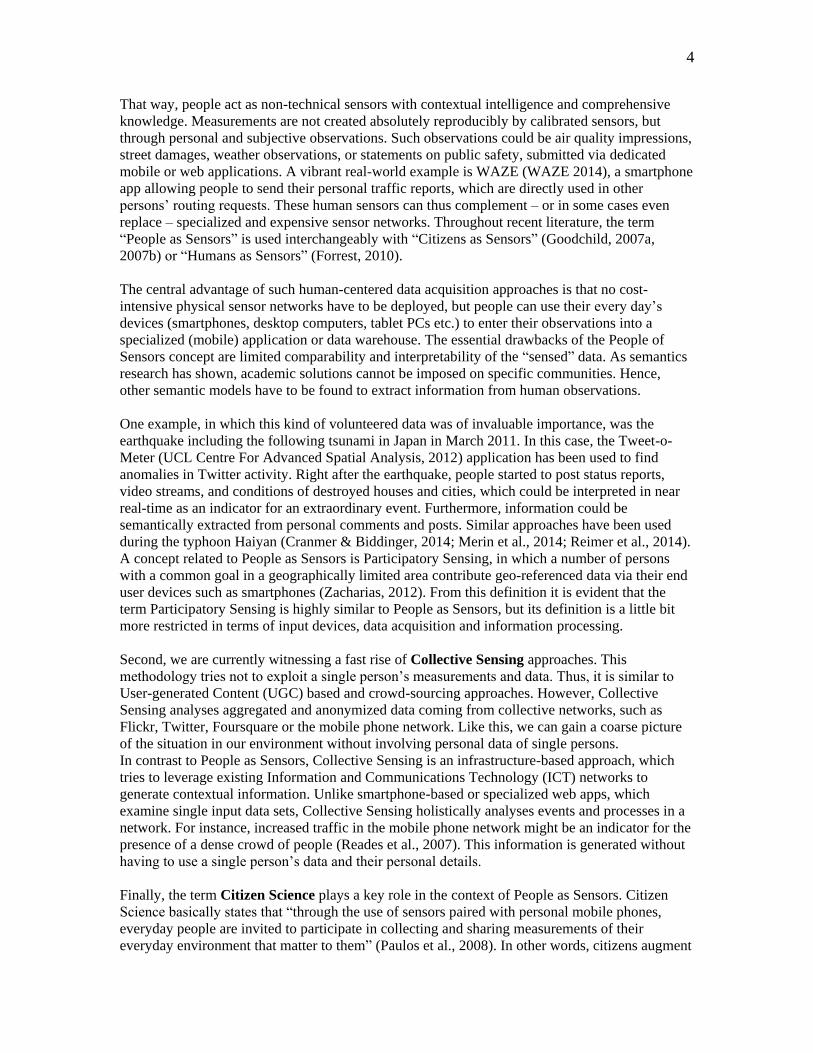
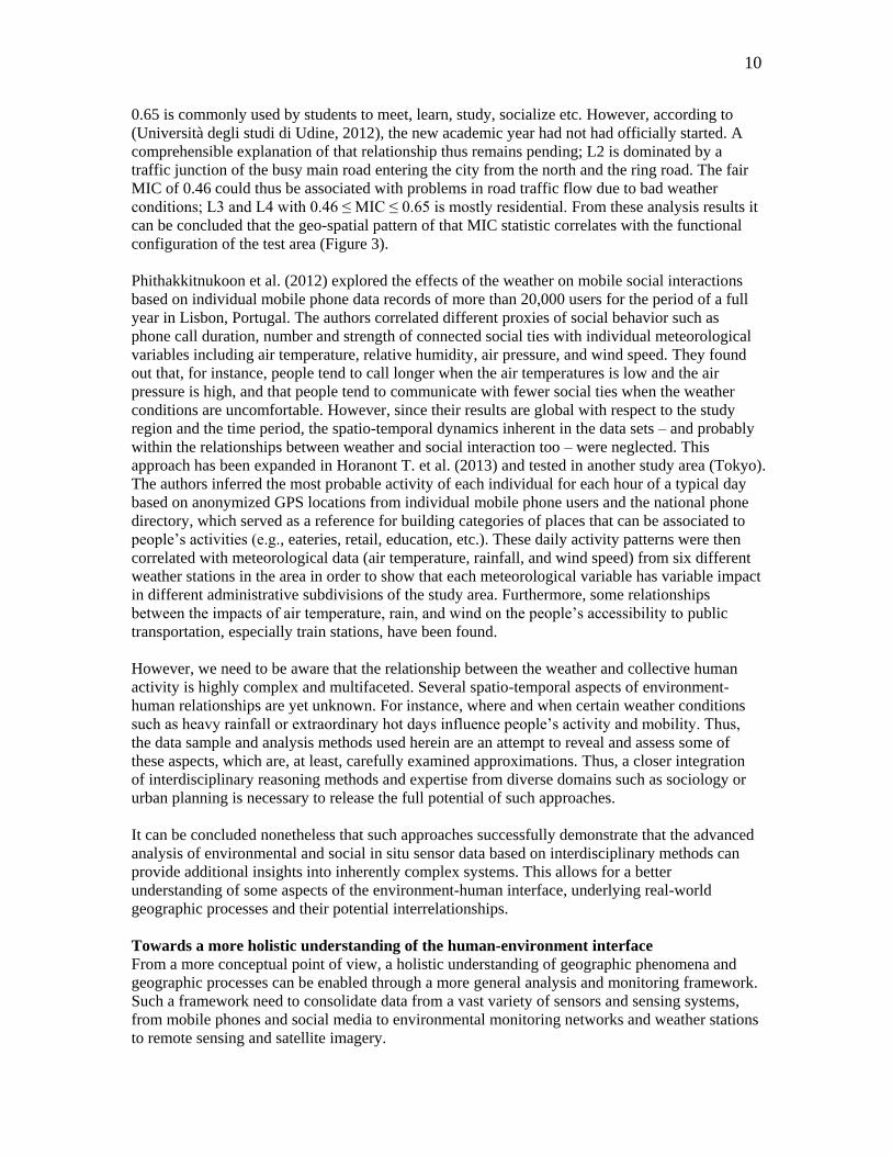
Figure 1: Redwood Watch Application for Forest Monitoring. (Save the Redwoods League, 2014)
In consequence, researchers hope that public understandings of science and environmental issues
will be improved and can have access to larger and more detailed data sets coupled with local
knowledge. This access to environmental data of the city also becomes a tool to raise the citizen
awareness of the state of their environment. Figure 1 shows the “Redwood Watch” location-based
application, which exploits Citizen Science to predict the growth of redwood forests (Save the
Redwoods League, 2014).
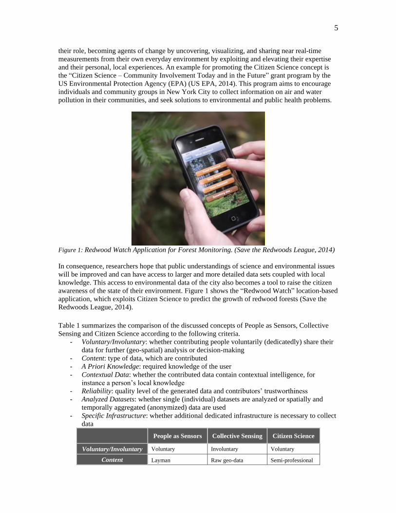
Table 1 summarizes the comparison of the discussed concepts of People as Sensors, Collective
Sensing and Citizen Science according to the following criteria.
- Voluntary/Involuntary: whether contributing people voluntarily (dedicatedly) share their
data for further (geo-spatial) analysis or decision-making
- Content: type of data, which are contributed
- A Priori Knowledge: required knowledge of the user
- Contextual Data: whether the contributed data contain contextual intelligence, for
instance a person’s local knowledge
- Reliability: quality level of the generated data and contributors’ trustworthiness
- Analyzed Datasets: whether single (individual) datasets are analyzed or spatially and
temporally aggregated (anonymized) data are used
- Specific Infrastructure: whether additional dedicated infrastructure is necessary to collect
data
People as Sensors Collective Sensing Citizen Science
Voluntary/Involuntary Voluntary Involuntary Voluntary
Content Layman Raw geo-data Semi-professional
6
Observations (images, tags, ...) Observations
A Priori Knowledge Medium Low/None High
Contextual Data Yes Yes Yes
Reliability Medium Mediocre Good
Analysed Datasets Individual Aggregated Individual
Specific Infrastructure No No No
Table 1: Comparison of Human-Centric Concepts.
Space-time patterns of human behavior derived from mobile phone data
Ubiquitous mobile communication technologies such as the mobile phone network are able to
directly or indirectly “sense” some aspects of the human behavior. The digital traces that people
continuously leave behind while using the mobile network reflect their behavior in great detail.
These traces can be seen as social sensor data (Sagl et al., 2012c) and can serve as proxy for
human activity and mobility. This has already proved successful in several investigations and is
documented in a huge body of scientific literature (Calabrese et al., 2013; Candia et al., 2008;
Farrahi & Gatica-Perez, 2011, 2012; González et al., 2008; Hidalgo & Rodriguez-Sickert, 2008;
Järv et al., 2014; Khan et al., 2013; Krygsman et al., 2007; Louail et al., 2014; Noulas et al., 2012;
Onnela et al., 2007; Ratti et al., 2006; Reades et al., 2009; Rose, 2006; Sagl et al., 2014; Shoval,
2007; Trasarti et al., in press). A spatial and temporal analysis of such proxy-data can provide
additional insights into the social dimension of inherently complex urban systems. For instance,
the analysis results in Sagl et al. (2012b) show that characteristic and exceptional urban mobility
patterns can be derived from handovers (i.e., the transfer of mobile communications sessions
from one radio cell to another while the mobile phone user is on the move) using a Visual
Analytics approach. Such patterns are potentially important for applications such as real-time
monitoring of events since the absolute net migration flow between pairs of radio cells can be
used for a rough estimation of the number of people on the move.
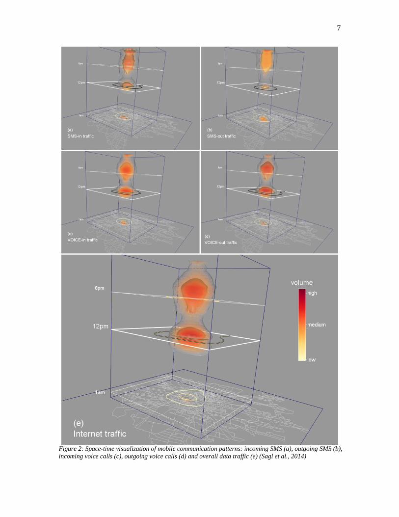
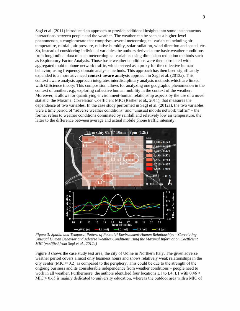
Recent research has shown that mobile communication profiles including incoming and outgoing
voice, text and data communication can be used as proxy for different collective human activity
patterns (Sagl et al., 2014). For this, the authors focused on the variations in intensity and
similarity of collective human activity by analyzing vast volumes of user-generated mobile
network traffic data with Geo-visual Analytics (Geo-VA), Self-Organizing Maps (SOM) and
Local Indicators of Spatial Association (LISA). Figure 2 shows the space-time patterns of typical
mobile communication in the city of Udine, Northern Italy, of a three month period in 2009. The
five different variables tend to exhibit similar patterns: a larger cluster of cells in the center of
town is particularly active around noon and after 6 pm again. The second temporal cluster is more
elongated for SMSs than phone calls, probably owing to the fact that several public companies or
office close their business at night. Such insights can help to better understand the daily “pulse”
of urban movements in the city (Sevtsuk & Ratti, 2010), thereby providing additional information
for a variety of application domains, e.g., public transportation, event management, urban
planning, etc. In sum, the results show that variations in intensity and similarity of collective
human activity patterns correlate with the functional configuration of a city.
7
Figure 2: Space-time visualization of mobile communication patterns: incoming SMS (a), outgoing SMS (b),
incoming voice calls (c), outgoing voice calls (d) and overall data traffic (e) (Sagl et al., 2014)
8
However, several limitations of such approaches exist. Although mobile phones as ubiquitous in
situ sensors can help us understand the spatio-temporal behavior pattern of humans and of groups,
they cannot tell us the underlying semantics – the “why” behind that patterns. Nonetheless, such
patterns can be the starting point of further interdisciplinary reasoning to disclose underlying
processes.
Exploring Human Behavior in the Environmental Context
As discussed in the previous section, human behavior patterns can be derived on the basis of data
from ubiquitous mobile in situ sensors – the mobile phones – and the user-generated mobile
network traffic. On the other hand, peoples’ living environments are monitored and assessed by a
variety of geo-spatial technologies such as remote sensing and especially in situ geo-sensor
networks (Blaschke et al., 2011; Hart & Martinez, 2006; Nittel, 2009; Nittel et al., 2008; Resch et
al., 2010a). The consolidation of environmental and social sensor data, which are inherently
different by nature, on a common space-time basis enables the analysis of potential relationships
and associations among such different data sets. This also requires the consideration of potential
influencing context factors.
The Role of Context in Human Behavior Analysis
A variety of diverse context factors influence the human behavior, the environmental context
factor is only one of them. Other contexts include mobility (e.g. Calabrese et al., 2011a; Traag et
al., 2011), activity (Girardin et al., 2009; Järv et al., 2014; Reades et al., 2009), and social
interactivity ( e.g. Calabrese et al., 2011b; Ratti et al., 2010). Human activity patterns of both
individuals (Phithakkitnukoon et al., 2010) and communities (Sevtsuk & Ratti, 2010) have been
evaluated in the context of urban planning (Becker et al., 2011; Reades et al., 2009), or
transportation (Di Lorenzo & Calabrese, 2011). In the context of scale, the human-city interaction
system developed by Martino et al. (Martino et al., 2010) provides an interactive visualization of
human movements across multiple temporal and spatial scales. Calabrese et al. (2010) consider
the context of social events and demonstrate that residents are more attracted to events if the
events take place close to the residents’ home location. Phithakkitnukoon et al. (2010) found out
that specific daily patterns of human activity strongly correlate with certain geographic areas that
share a common characteristic context, for instance shopping or eating. From such examples, it
can be concluded that the respective context should be taken into account when analyzing human
behavior. However, the environmental context has rarely been considered when analyzing human
and social dynamics.
Correlating Weather and Human Behavior based on Social and Environmental Sensor Data
The relationships between the weather and humans behavior are multifaceted. For instance, the
combination of some meteorological variables such as air temperature, solar radiation, relative
humidity, or a combination of these can effect peoples’ comfort conditions in outdoor urban
spaces (Stathopoulos et al., 2004), poor or extreme weather conditions influence peoples physical
activity (Tucker & Gilliland, 2007), etc. Vice versa, significant changes in the collective human
mobility behavior can be linked with changes in the intensity of use and the choice of the
transport vehicle (e.g. car, bus, train etc.). The vehicles’ emissions influence, e.g., the air quality
along streets at different times (Nicolopoulou-Stamati et al., 2005). Further, as we experience in
our daily live, certain weather conditions such as low pressure systems with heavy rainfall
obviously have a certain impact on our behavior. Only a few approaches exist that explicitly
address weather as the environmental context and explore potential relationships and interaction
between the weather and the human behavior on an urban scale in both space and time. Moreover,
some kind of methodology that allows for quantifying such potential relationships can hardly be
found in scientific literature.
9
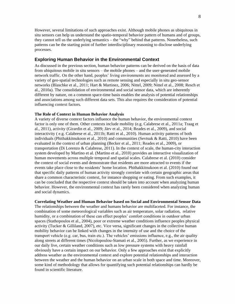
Sagl et al. (2011) introduced an approach to provide additional insights into some instantaneous
interactions between people and the weather. The weather can be seen as a higher-level
phenomenon, a conglomerate that comprises several meteorological variables including air
temperature, rainfall, air pressure, relative humidity, solar radiation, wind direction and speed, etc.
So, instead of considering individual variables the authors derived some basic weather conditions
from longitudinal data of such meteorological variables using dimension reduction methods such
as Exploratory Factor Analysis. Those basic weather conditions were then correlated with
aggregated mobile phone network traffic, which served as a proxy for the collective human
behavior, using frequency domain analysis methods. This approach has then been significantly
expanded to a more advanced context-aware analysis approach in Sagl et al. (2012a). This
context-aware analysis approach integrates interdisciplinary analysis methods which are linked
with GIScience theory. This composition allows for analyzing one geographic phenomenon in the
context of another, e.g., exploring collective human mobility in the context of the weather.
Moreover, it allows for quantifying environment-human relationship aspects by the use of a novel
statistic, the Maximal Correlation Coefficient MIC (Reshef et al., 2011), that measures the
dependence of two variables. In the case study performed in Sagl et al. (2012a), the two variables
were a time period of “adverse weather conditions” and “unusual mobile network traffic” – the
former refers to weather conditions dominated by rainfall and relatively low air temperature, the
latter to the difference between average and actual mobile phone traffic intensity.
Figure 3: Spatial and Temporal Pattern of Potential Environment-Human Relationships – Correlating
Unusual Human Behavior and Adverse Weather Conditions using the Maximal Information Coefficient
MIC (modified from Sagl et al., 2012a)
Figure 3 shows the case study test area, the city of Udine in Northern Italy. The given adverse
weather period covers almost only business hours and shows relatively weak relationships in the
city center (MIC ≈ 0.2) as compared to the periphery. This could be due to the strength of the
ongoing business and its considerable independence from weather conditions – people need to
work in all weather. Furthermore, the authors identified four locations L1 to L4: L1 with 0.46 ≤
MIC ≤ 0.65 is mainly dedicated to university education, whereas the outdoor area with a MIC of
10
0.65 is commonly used by students to meet, learn, study, socialize etc. However, according to
(Università degli studi di Udine, 2012), the new academic year had not had officially started. A
comprehensible explanation of that relationship thus remains pending; L2 is dominated by a
traffic junction of the busy main road entering the city from the north and the ring road. The fair
MIC of 0.46 could thus be associated with problems in road traffic flow due to bad weather
conditions; L3 and L4 with 0.46 ≤ MIC ≤ 0.65 is mostly residential. From these analysis results it
can be concluded that the geo-spatial pattern of that MIC statistic correlates with the functional
configuration of the test area (Figure 3).
Phithakkitnukoon et al. (2012) explored the effects of the weather on mobile social interactions
based on individual mobile phone data records of more than 20,000 users for the period of a full
year in Lisbon, Portugal. The authors correlated different proxies of social behavior such as
phone call duration, number and strength of connected social ties with individual meteorological
variables including air temperature, relative humidity, air pressure, and wind speed. They found
out that, for instance, people tend to call longer when the air temperatures is low and the air
pressure is high, and that people tend to communicate with fewer social ties when the weather
conditions are uncomfortable. However, since their results are global with respect to the study
region and the time period, the spatio-temporal dynamics inherent in the data sets – and probably
within the relationships between weather and social interaction too – were neglected. This
approach has been expanded in Horanont T. et al. (2013) and tested in another study area (Tokyo).
The authors inferred the most probable activity of each individual for each hour of a typical day
based on anonymized GPS locations from individual mobile phone users and the national phone
directory, which served as a reference for building categories of places that can be associated to
people’s activities (e.g., eateries, retail, education, etc.). These daily activity patterns were then
correlated with meteorological data (air temperature, rainfall, and wind speed) from six different
weather stations in the area in order to show that each meteorological variable has variable impact
in different administrative subdivisions of the study area. Furthermore, some relationships
between the impacts of air temperature, rain, and wind on the people’s accessibility to public
transportation, especially train stations, have been found.
However, we need to be aware that the relationship between the weather and collective human
activity is highly complex and multifaceted. Several spatio-temporal aspects of environment-
human relationships are yet unknown. For instance, where and when certain weather conditions
such as heavy rainfall or extraordinary hot days influence people’s activity and mobility. Thus,
the data sample and analysis methods used herein are an attempt to reveal and assess some of
these aspects, which are, at least, carefully examined approximations. Thus, a closer integration
of interdisciplinary reasoning methods and expertise from diverse domains such as sociology or
urban planning is necessary to release the full potential of such approaches.
It can be concluded nonetheless that such approaches successfully demonstrate that the advanced
analysis of environmental and social in situ sensor data based on interdisciplinary methods can
provide additional insights into inherently complex systems. This allows for a better
understanding of some aspects of the environment-human interface, underlying real-world
geographic processes and their potential interrelationships.
Towards a more holistic understanding of the human-environment interface
From a more conceptual point of view, a holistic understanding of geographic phenomena and
geographic processes can be enabled through a more general analysis and monitoring framework.
Such a framework need to consolidate data from a vast variety of sensors and sensing systems,
from mobile phones and social media to environmental monitoring networks and weather stations
to remote sensing and satellite imagery.
11
Montgomery and Mundt (2010) describe a comprehensive but rather technical framework of how
to combine and integrate various sensor data into a common platform on an almost global level.
At a regional or even local level, Blaschke et al. (2011, p1762) claim: “What is really needed is a
better understanding of human-environmental processes, i.e., direct measures of the impact of
human activities on the environment and direct measures of environmental stressors on human
functions.”
The adaptive geo-monitoring framework (Sagl, 2012), which extends the adaptive monitoring
approach (Lindenmayer & Likens, 2009) by adding the geo-spatial dimension, introduces one
possibility to consider the mutual context-awareness when analyzing and monitoring dynamic
geographic phenomena. Therefore, such a framework potentially provides novel capabilities for
investigating the spatio-temporal behavior of physical and social phenomena through ubiquitous
sensing and context-aware analysis, thereby enabling a more holistic understanding of the human-
environment interface.
CONCLUSION AND FUTURE RESEARCH DIRECTIONS
In this chapter we provided a brief overview of the field of using mobile phones as ubiquitous
geo-sensors in the overarching context of investigating human and environmental dynamics. We
presented several influencing scholars and institutions in the context of that field. Further, we
elaborated on three related research areas: human-centered data acquisition using mobile phones,
space-time patterns of human behavior derived from mobile phone data, and exploring human
behavior in the environmental context. Within these three areas, we emphasized the inherent
spatial and temporal characteristics from a GIScience / Geoinformatics perspective. From a
broader view point, the approaches and research outcomes presented herein thus facilitates the
concept of a “Digital Earth” (Goodchild et al., 2012; Gore, 1998) and the metaphor of an
“Electronic Skin” of planet earth (Gross, 1999), which both emphasize the technological
innovations that provide unprecedented amount of digital data and information reflecting real-
world phenomena and processes in exceptional spatial and temporal detail.
However, we are aware that we had only investigated isolated aspects of social and
environmental dynamics, specifically in the sub-section on exploring the human behavior in the
environmental context. Without venturing into a debate of environmental determinism, we state
that many factors influence the collective human behavior, and the weather is certainly only one
of these factors. The case studies described demonstrate that human-environmental relationships
can be investigated, in principal, based on diverse “sensor data”. We need to be reminded that
such data, although increasingly vast in volumes and available even in real-time, are still “just”
digital samples, and thus proxies of the phenomena or processes of interest – which are typically
much more complex. Further, to what degree the results explain causalities will depend on
interdisciplinary expert knowledge, as well as on the field of application.
Hence, a number of challenges remain for future research and deeper investigations of human and
environmental dynamics – several of them go beyond the use of mobile phones as ubiquitous
mobile geo-sensors:
The different nature of user-generated data results in differences in terms of
representativeness and semantic expressiveness: the, from a user’s perspective,
“involuntary” generated mobile network traffic data represent a relatively large
proportion of the population across social classes, however, these data are typically
lacking in content. For instance, the number of text messages sent or received is known
but not the text itself, or the number and duration of voice calls is known but not the topic
12
of the talk itself, or the number and duration of data connection is known but not the
content of the data and information transferred. This is in contrast to social media data
and VGI, which is typically generated by a rather specific sub group of the population,
and explicitly contain content of some semantic value.
Some phenomena are sensed directly and for a predefined reason while others are sensed
indirectly or possibly not even intended to be sensed. For instance, certain quality criteria
of an air temperature sensor ought to be documented in its technical specification. So, the
sensor’s measurement accuracy is to that degree reliable. On the other hand, the user-
generated traffic in mobile networks is managed by the network’s backend in order to
enable mobile people to communicate wirelessly everywhere at any time. Just as a by-
product, the log files from such a backend can reflect the human behavior patterns of
millions of mobile users. In other words, the spatio-temporal dynamics of the phenomena
of interest can either be “guaranteed” (in the case of the air temperature) or fairly be
assumed (in the case of human behavior) to be reflected in the sensor data. As a result,
the sensor data’s context and purpose can vary considerably. Thus, an interdisciplinary
challenge is the extraction of significant spatio-temporal information from such diverse
sensor data that are different by nature and comprise differences in semantic
expressiveness.
A connected methodological issue in the field of semantics is representativeness in VGI.
This has to be tackled by a combined bottom-up/top-down approach. In bottom-up
approaches, user groups and communities define their own semantic objects and
interrelations between these in separate taxonomies. In contrast, top-down approaches try
to define semantic rules and ontological relations as generically as possible – mostly
before actual applications exist and decoupled from real-world use cases. Only the
combination of those approaches can result in trans-domain semantic models, which are
linked via object relations.
The requirement of high-quality information seems to be self-evident, but has not been
tackled thoroughly for real-time geo-sensor networks and People as Sensors based
approaches. Subjective human “measurements” naturally raises the question of
trustworthiness of these data in terms of data quality. As discussed above, this result in
uncertainty in the observed phenomenon. Thus, automated quality assurance mechanisms
have to be developed for uncertainty estimation, dynamic error detection, correction and
prevention. Different approaches are in development, e.g., Complex Event Processing
(CEP) (Resch et al., 2010b) for error detection, standardization efforts for representing
uncertainty in sensor data (e.g. Uncertainty Markup Language - UncertML) (Williams,
2008), or proprietary profiles to define validity ranges for particular observations. Such
issues need to be solved in order to ensure reliability of both technical and human sensor
data.
Furthermore, how can we preserve people’s privacy is a crucial question when dealing with
user-generated data and information and partly personal data, and thus sensitive data in the
context of mobile phones as ubiquitous in situ geo-sensors. In terms of privacy, the claim might
arise that we need to be aware of our personal and private data before we share them. This also
raises the need to discuss the concept of U-VGI, i.e. Un-Volunteered Geographic Information, in
contrast to VGI. For instance, collective sensing approaches exploit anonymized data from digital
networks (e.g. by deducing crowd movements from traffic distribution in the cell phone network)
even though people have not intended to share their data in this way.
13
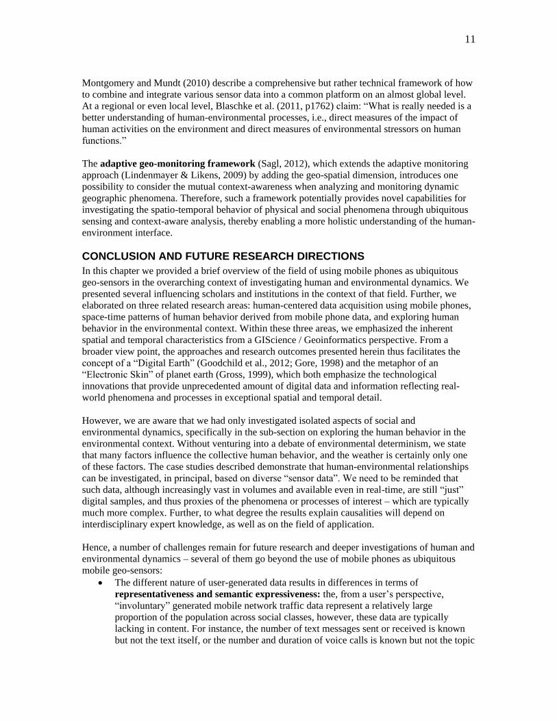
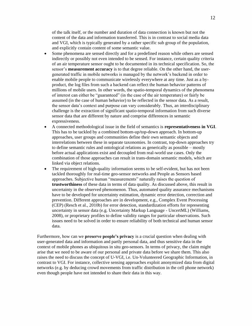
Figure 4: Understanding of Privacy vs. the Government’s Role in Regulation.
As mobile phone data and human sensor data are individual oftentimes sensitive, legal
frameworks have to be developed on national, trans-national and global levels to protect those
personal data. The largest limiting factor in this regard is the varying interpretation of ‘privacy’ in
different parts of the world. For instance, privacy can be traded like an economic good by its
owner in the USA, whereas it is protected by law in the European Union. This means that supra-
national legislation bodies and initiatives are called upon to set up appropriate world-wide
regulations. As shown in Figure 4, legislation and governments play a highly different role in
these two settings.
This also includes the critical question of data ownership – who owns the data? Is it the data
producers, i.e., the citizens or a mobile phone network operator? Is it the institutions that host a
system in order to collect data? Is it the data providers? Furthermore, if sensitive data is analyzed
to produce anonymized information layers, who is responsible if decisions that are based on this
information are wrong due to lacking quality of the base data? In conclusion, the issues of privacy,
data ownership, accessibility, integrity and liability have to be tackled thoroughly all at once and
not separately from each other.
REFERENCES
Barabasi, A.-L. (2005). The origin of bursts and heavy tails in human dynamics. Nature,
435(7039), 207-211. doi:
http://www.nature.com/nature/journal/v435/n7039/suppinfo/nature03459_S1.html
Becker, R. A., Caceres, R., Hanson, K., Loh, J. M., Urbanek, S., Varshavsky, A., & Volinsky, C.
(2011). A Tale of One City: Using Cellular Network Data for Urban Planning. IEEE PERVASIVE
computing, 10(4), 18-26. doi: 10.1109/mprv.2007.27
Blaschke, T., Hay, G. J., Weng, Q., & Resch, B. (2011). Collective Sensing: Integrating
Geospatial Technologies to Understand Urban Systems—An Overview. Remote Sensing, 3(8),
1743-1776.
14
Calabrese, F., Colonna, M., Lovisolo, P., Parata, D., & Ratti, C. (2011a). Real-Time Urban
Monitoring Using Cell Phones: A Case Study in Rome. IEEE Transactions on Intelligent
Transportation Systems, 12(1), 141-151.
Calabrese, F., Dahlem, D., Gerber, A., Paul, D., Chen, X., Rowland, J., Rath, C., & Ratti, C.
(2011b). The Connected States of America: Quantifying Social Radii of Influence. Paper
presented at the The Third IEEE International Conference on Social Computing (SocialCom),
Boston, USA.
Calabrese, F., Diao, M., Di Lorenzo, G., Ferreira Jr, J., & Ratti, C. (2013). Understanding
individual mobility patterns from urban sensing data: A mobile phone trace example.
Transportation Research Part C: Emerging Technologies, 26(0), 301-313. doi:
http://dx.doi.org/10.1016/j.trc.2012.09.009
Calabrese, F., Pereira, F. C., Lorenzo, G. D., Liu, L., & Ratti, C. (2010). The geography of taste:
analyzing cell-phone mobility and social events Pervasive Computing (Lecture Notes in
Computer Science) (Vol. 6030/2010, pp. 22-37). Berlin / Heidelberg: Springer.
Calabrese, F., Smoreda, Z., Blondel, V., & Ratti, C. (2011c). The interplay between
telecommunications and face-to-face interactions - an initial study using mobile phone data.
Physics and Society [physics.soc-ph]. doi: citeulike-article-id:8691602
Candia, J., González, M. C., PuWang, Schoenharl, T., Madey, G., & Barabási, A.-L. (2008).
Uncovering individual and collective human dynamics from mobile phone records. Journal of
Physics A: Mathematical and Theoretical, 41(22), 224015.
Cranmer, H. H., & Biddinger, P. D. (2014). Typhoon Haiyan and the Professionalization of
Disaster Response. New England Journal of Medicine, 370(13), 1185-1187. doi:
doi:10.1056/NEJMp1401820
Di Lorenzo, G., & Calabrese, F. (2011). Identifying human spatio-temporal activity patterns from
mobile-phone traces. Paper presented at the Intelligent Transportation Systems (ITSC), 2011 14th
International IEEE Conference on Washington, DC, USA.
Elwood, S. (2008a). Volunteered geographic information: future research directions motivated by
critical, participatory, and feminist GIS. GeoJournal, 72(3-4), 173-183.
Elwood, S. (2008b). Volunteered geographic information: key questions, concepts and methods
to guide emerging research and practice. GeoJournal, 72(3), 133-135.
Elwood, S. (2010). Geographic information science: emerging research on the societal
implications of the geospatial web. Progress in Human Geography, 34(3), 349-357. doi:
10.1177/0309132509340711
Farrahi, K., & Gatica-Perez, D. (2011). Discovering routines from large-scale human locations
using probabilistic topic models. ACM Trans. Intell. Syst. Technol., 2(1), 1-27. doi:
10.1145/1889681.1889684
Farrahi, K., & Gatica-Perez, D. (2012, June 29 - July 1). Extracting Mobile Behavioral Patterns
with the Distant N-Gram Topic Model. Paper presented at the International Symposium on
Wearable Computers ISWC, Newcastle, UK.
15
Forrest, B. (2010). Humans as sensors. LBX Journal. http://www.lbxjournal.com/articles/humans-
sensors/260057
Girardin, F., Blat, J., Calabrese, F., Fiore, F. D., & Ratti, C. (2008). Digital Footprinting:
Uncovering Tourists with User-Generated Content. IEEE PERVASIVE computing, 7(4), 36-43.
Girardin, F., Vaccari, A., Gerber, A., Biderman, A., & Ratti, C. (2009). Quantifying urban
attractiveness from the distribution and density of digital footprints. International Journal of
Spatial Data Infrastructures Research, 4, 175-200.
González, M. C., & Barabási, A.-L. (2007). Complex Networks from Data to Models. Nature
Physics, 3, 224-225.
González, M. C., Hidalgo, C. A., & Barabási, A.-L. (2008). Understanding individual human
mobility patterns. Nature, 453(5), 779-782.
Goodchild, M. (2009). NeoGeography and the nature of geographic expertise. Journal of
Location Based Services, 3(2), 82-96.
Goodchild, M. F. (2007a). Citizens as sensors: the world of volunteered geography. GeoJournal,
69(4), 211-221.
Goodchild, M. F. (2007b). Citizens as Voluntary Sensors: Spatial Data Infrastructure in the
World of Web 2.0. International Journal of Spatial Data Infrastructure Research, 2, 24-32.
Goodchild, M. F., Guo, H., Annoni, A., Bian, L., de Bie, K., Campbell, F., Craglia, M., Ehlers,
M., van Genderen, J., Jackson, D., Lewis, A. J., Pesaresi, M., Remetey-Fülöpp, G., Simpson, R.,
Skidmore, A., Wang, C., & Woodgate, P. (2012). Next-generation Digital Earth. Proceedings of
the National Academy of Sciences, 109(28), 11088-11094. doi: 10.1073/pnas.1202383109
Gore, A. (1998). The Digital Earth: Understanding our planet in the 21st Century. Retrieved
2011/10/08, from http://portal.opengeospatial.org/files/?artifact_id=6210
Gross, N. (1999). The Earth Will Don an Electronic Skin. BusinessWeek Online.
http://www.businessweek.com/1999/99_35/b3644024.htm
Hancke, G., Silva, B., & Hancke, J., Gerhard. (2013). The Role of Advanced Sensing in Smart
Cities. Sensors, 13(1), 393-425.
Hart, J. K., & Martinez, K. (2006). Environmental Sensor Networks: A revolution in the earth
system science? Earth-Science Reviews, 78, 177-191.
Hidalgo, C. A., & Rodriguez-Sickert, C. (2008). The dynamics of a mobile phone network.
Physica A: Statistical Mechanics and its Applications, 387(12), 3017-3024.
Horanont T., Phithakkitnukoon S., Leong T.W., Sekimoto Y., & Shibasaki R. (2013). Weather
Effects on the Patterns of People's Everyday Activities: A Study Using GPS Traces of Mobile
Phone Users. PLoS One, 8(12), e81153. doi: doi:10.1371/journal.pone.0081153
Hsiang, S. M., Meng, K. C., & Cane, M. A. (2011). Civil conflicts are associated with the global
climate. Nature, 476(7361), 438-441. doi:
16
http://www.nature.com/nature/journal/v476/n7361/abs/nature10311.html#supplementary-
information
Järv, O., Ahas, R., & Witlox, F. (2014). Understanding monthly variability in human activity
spaces: A twelve-month study using mobile phone call detail records. Transportation Research
Part C: Emerging Technologies, 38(0), 122-135. doi: http://dx.doi.org/10.1016/j.trc.2013.11.003
Khan, W. Z., Yang, X., Aalsalem, M. Y., & Arshad, Q. (2013). Mobile Phone Sensing Systems:
A Survey. Communications Surveys & Tutorials, IEEE, 15(1), 402-427. doi:
10.1109/SURV.2012.031412.00077
Kloeckl, K., Senn, O., & Ratti, C. (2012). Enabling the Real-Time City: LIVE Singapore!
Journal of Urban Technology, 19(2), 89-112. doi: 10.1080/10630732.2012.698068
Krings, G., Calabrese, F., Ratti, C., & Blondel, V. D. (2009). Urban gravity: a model for inter-city
telecommunication flows. Journal of Statistical Mechanics: Theory and Experiment, 2009(7).
Krygsman, S., de Jong, T., & Schmitz, P. (2007). Capturing daily urban rhythms: The use of
location aware technologies. Paper presented at the Computers in Urban Planning and Urban
Management, 10th International Conference, Iguassu Falls, Brazil.
Laituri, M., & Kodrich, K. (2008). On Line Disaster Response Community: People as Sensors of
High Magnitude Disasters Using Internet GIS. Sensors, 8(5), 3037-3055.
Lane, N. D., Miluzzo, E., Lu, H., Peebles, D., Choudhury, T., & Campbell, A. T. (2010). A
survey of mobile phone sensing. IEEE Communications Magazine, 48(9), 140-150.
Lindenmayer, D. B., & Likens, G. E. (2009). Adaptive monitoring: a new paradigm for long-term
research and monitoring. Trends in Ecology & Evolution, 24(9), 482-486. doi:
10.1016/j.tree.2009.03.005
Louail, T., Lenormand, M., Cantú, O. G., Picornell, M., Herranz, R., Frias-Martinez, E., Ramasco,
J. J., & Barthelemy, M. (2014). From mobile phone data to the spatial structure of cities. arXiv
preprint arXiv:1401.4540.
Martino, M., Calabrese, F., Lorenzo, G. D., Andris, C., Liu, L., & Ratti, C. (2010). Ocean of
Information: Fusing Aggregate & Individual Dynamics for Metropolitan Analysis. Paper
presented at the 15th international Conference on Intelligent User Interfaces, Hong Kong, China
McLeman, R. A., & Hunter, L. M. (2010). Migration in the context of vulnerability and
adaptation to climate change: insights from analogues. Wiley Interdisciplinary Reviews: Climate
Change, 1(3), 450-461. doi: 10.1002/wcc.51
Merin, O., Kreiss, Y., Lin, G., Pras, E., & Dagan, D. (2014). Collaboration in Response to
Disaster — Typhoon Yolanda and an Integrative Model. New England Journal of Medicine,
370(13), 1183-1184. doi: doi:10.1056/NEJMp1315960
Miluzzo, E., Lane, N. D., Krist, #243, Fodor, f., Peterson, R., Lu, H., Musolesi, M., Eisenman, S.
B., Zheng, X., & Campbell, A. T. (2008). Sensing meets mobile social networks: the design,
implementation and evaluation of the CenceMe application. Paper presented at the Proceedings
of the 6th ACM conference on Embedded network sensor systems, Raleigh, NC, USA.
17
Montgomery, K., & Mundt, C. (2010). A new paradigm for integrated environmental monitoring.
Paper presented at the Proceedings of the 1st International Conference and Exhibition on
Computing for Geospatial Research, Washington, D.C.
Nicolopoulou-Stamati, P., Hens, L., & Howard, V. (2005). Environmental health impacts of
transport and mobility (Vol. 21): Springer Verlag Dordrecht, The Netherlands.
Nittel, S. (2009). A Survey of Geosensor Networks: Advances in Dynamic Environmental
Monitoring. Sensors, 9(7), 5664-5678.
Nittel, S., Labrinidis, A., & Stefanidis, A. (2008). Introduction to Advances in Geosensor
Networks. In N. Silvia, L. Alexandros & S. Anthony (Eds.), GeoSensor Networks (pp. 1-6):
Springer-Verlag.
Noulas, A., Scellato, S., Lambiotte, R., Pontil, M., & Mascolo, C. (2012). A Tale of Many Cities:
Universal Patterns in Human Urban Mobility. PLoS One, 7(5), e37027. doi:
10.1371/journal.pone.0037027
Onnela, J. P., Saramäki, J., Hyvönen, J., Szabó, G., Lazer, D., Kaski, K., Kertész, J., & Barabási,
A. L. (2007). Structure and tie strengths in mobile communication networks. Proceedings of the
National Academy of Sciences, 104(18), 7332-7336. doi: citeulike-article-id:1675671
Overeem, A., R. Robinson, J. C., Leijnse, H., Steeneveld, G. J., P. Horn, B. K., & Uijlenhoet, R.
(2013). Crowdsourcing urban air temperatures from smartphone battery temperatures.
Geophysical Research Letters, 40(15), 4081-4085. doi: 10.1002/grl.50786
Paulos, E., Honicky, R., & Hooker, B. (2008). Citizen science: Enabling participatory urbanism.
Handbook of Research on Urban Informatics, 414-436.
Perreault, M., & Ruths, D. (2011). The effect of mobile platforms on Twitter content generation.
Paper presented at the Proceedings of the Fifth International Conference on Weblogs and Social
Media., Barcelona (Spain).
Phithakkitnukoon, S., Horanont, T., Di Lorenzo, G., Shibasaki, R., & Ratti, C. (2010). Activity-
Aware Map: Identifying Human Daily Activity Pattern Using Mobile Phone Data. In A. Salah, T.
Gevers, N. Sebe & A. Vinciarelli (Eds.), Human Behavior Understanding (Vol. 6219, pp. 14-25):
Springer Berlin / Heidelberg.
Phithakkitnukoon, S., Leong, T. W., Smoreda, Z., & Olivier, P. (2012). Weather effects on
mobile social interactions: a case study of mobile phone users in Lisbon, Portugal. PLoS One,
7(10), e45745.
Quercia, D. L., N.; Calabrese, F.; Di Lorenzo, G.; Crowcroft, J.;. (2010, December 13-17).
Recommending Social Events from Mobile Phone Location Data. Paper presented at the 10th
IEEE International Conference on Data Mining (ICDM2010), Sydney, Australia.
Ratti, C., Pulselli, R. M., Williams, S., & Frenchman, D. (2006). Mobile Landscapes: using
location data from cell phones for urban analysis. Environment and Planning B: Planning and
Design, 33(5), 727-748.
18
Ratti, C., Sevtsuk, A., Huang, S., & Pailer, R. (2007). Mobile Landscapes: Graz in Real Time. In
G. Gartner, W. Cartwright & M. P. Peterson (Eds.), Location Based Services and
TeleCartography (pp. 433-444): Springer Berlin Heidelberg.
Ratti, C., Sobolevsky, S., Calabrese, F., Andris, C., Reades, J., Martino, M., Claxton, R., &
Strogatz, S. H. (2010). Redrawing the Map of Great Britain from a Network of Human
Interactions. PLoS One, 5(12), e14248. doi: doi:10.1371/journal.pone.0014248
Reades, J., Calabrese, F., & Ratti, C. (2009). Eigenplaces: analysing cities using the space-time
structure of the mobile phone network. Environment and Planning B: Planning and Design, 36(5),
824-836.
Reades, J., Calabrese, F., Sevtsuk, A., & Ratti, C. (2007). Cellular Census: Explorations in Urban
Data Collection. IEEE PERVASIVE computing, 6(3), 30-38.
Reimer, A., Neis, P., Rylov, M., Schellhorn, S., Sagl, G., Resch, B., Porto, J., & Zipf, A. (2014,
March 26 - 28). Erfahrungsbericht Crisis Mapping zum Taifun Haiyan. Paper presented at the
Geoinformatik 2014, Hamburg, Germany.
Resch, B. (2013). People as Sensors and Collective Sensing-Contextual Observations
Complementing Geo-Sensor Network Measurements. In J. M. Krisp (Ed.), Progress in Location-
Based Services (pp. 391-406): Springer Berlin Heidelberg.
Resch, B., Blaschke, T., & Mittlboeck, M. (2010a). Live Geography: Interoperable Geo-Sensor
Webs Facilitating the Vision of Digital Earth. International Journal on Advances in Networks and
Service, Volume 3(Numbers 3 & 4), 323-332.
Resch, B., Mittlboeck, M., & Lippautz, M. (2010b). Pervasive Monitoring—An Intelligent
Sensor Pod Approach for Standardised Measurement Infrastructures. Sensors, 10, 11440-11467.
Reshef, D. N., Reshef, Y. A., Finucane, H. K., Grossman, S. R., McVean, G., Turnbaugh, P. J.,
Lander, E. S., Mitzenmacher, M., & Sabeti, P. C. (2011). Detecting novel associations in large
data sets. Science, 334(6062), 1518-1524.
Rose, G. (2006). Mobile Phones as Traffic Probes: Practices, Prospects and Issues. Transport
Reviews: A Transnational Transdisciplinary Journal, 26(3), 275 - 291.
Sagl, G. (2012, September 18 - 21). Towards Adaptive Geo-Monitoring: Examining
Environmental and Social Dynamics and their Relationships for Holistic Process Understanding.
Paper presented at the 7th International Conference on Geographic Information Science
(GIScience2012), Columbus, Ohio (USA).
Sagl, G., Beinat, E., Resch, B., & Blaschke, T. (2011, June 29 - July 1). Integrated Geo-Sensing:
a Case Study on the Relationships between Weather Conditions and Mobile Phone Usage in
Northern Italy. Paper presented at the First IEEE International Conference on Spatial Data
Mining and Geographical Knowledge Services (ICSDM 2011), Fuzhou, China.
Sagl, G., Blaschke, T., Beinat, E., & Resch, B. (2012a). Ubiquitous Geo-Sensing for Context-
Aware Analysis: Exploring Relationships between Environmental and Human Dynamics. Sensors,
12(7), 9835-9857.
19
Sagl, G., Delmelle, E., & Delmelle, E. (2014). Mapping collective human activity in an urban
environment based on mobile phone data. Cartography and Geographic Information Science, 1-
14. doi: 10.1080/15230406.2014.888958
Sagl, G., Loidl, M., & Beinat, E. (2012b). A Visual Analytics Approach for Extracting Spatio-
Temporal Urban Mobility Information from Mobile Network Traffic. ISPRS International
Journal of Geo-Information, 1(3), 256-271.
Sagl, G., Resch, B., Hawelka, B., & Beinat, E. (2012c). From Social Sensor Data to Collective
Human Behaviour Patterns: Analysing and Visualising Spatio-Temporal Dynamics in Urban
Environments. In T. Jekel, A. Car, J. Strobl & G. Griesebner (Eds.), GI-Forum 2012:
Geovisualization, Society and Learning (pp. 54-63): Wichmann Verlag, Berlin.
Save the Redwoods League. (2014). Redwoods & Climate Change Initiative. Retrieved
2014/03/22, from http://rcci.savetheredwoods.org/action
Sevtsuk, A., & Ratti, C. (2010). Does Urban Mobility Have a Daily Routine? Learning from the
Aggregate Data of Mobile Networks. Journal of Urban Technology, 17(1), 41-60.
Shoval, N. (2007). Sensing human society. Environment and Planning B: Planning and Design,
34(2), 191-195.
Simini, F., Gonzalez, M. C., Maritan, A., & Barabasi, A.-L. (2012). A universal model for
mobility and migration patterns. Nature, 484(7392), 96-100. doi:
http://www.nature.com/nature/journal/v484/n7392/abs/nature10856.html#supplementary-
information
Sneha, S., & Varshney, U. (2009). Enabling ubiquitous patient monitoring: Model, decision
protocols, opportunities and challenges. Decision Support Systems, 46(3), 606-619. doi:
http://dx.doi.org/10.1016/j.dss.2008.11.014
Stathopoulos, T., Wu, H., & Zacharias, J. (2004). Outdoor human comfort in an urban climate.
Building and Environment, 39(3), 297-305. doi: 10.1016/j.buildenv.2003.09.001
Tacoli, C. (2009). Crisis or adaptation? Migration and climate change in a context of high
mobility. Environment and Urbanization, 21(2), 513-525. doi: 10.1177/0956247809342182
Traag, V. A., Browet, A., Calabrese, F., & Morlot, F. (2011). Social Event Detection in Massive
Mobile Phone Data Using Probabilistic Location Inference. Paper presented at the The Third
IEEE International Conference on Social Computing (SocialCom), Boston, USA.
Trasarti, R., Olteanu-Raimond, A.-M., Nanni, M., Couronné, T., Furletti, B., Giannotti, F.,
Smoreda, Z., & Ziemlicki, C. (in press). Discovering urban and country dynamics from mobile
phone data with spatial correlation patterns. Telecommunications Policy(0), pending. doi:
http://dx.doi.org/10.1016/j.telpol.2013.12.002
Tucker, P., & Gilliland, J. (2007). The effect of season and weather on physical activity: A
systematic review. Public Health, 121(12), 909-922. doi: 10.1016/j.puhe.2007.04.009
20
UCL Centre For Advanced Spatial Analysis. (2012). Tweet-o-Meter - Giving You an Insight into
Twitter Activity from Around the World! Retrieved 2014/03/24, from
http://www.casa.ucl.ac.uk/tom
Università degli studi di Udine. (2012). Official website. Retrieved 2012/06/11, from
http://www.uniud.it/didattica/facolta/interfacolta/biotecnologie/info_dida/calendario_accademico
US EPA. (2014). Citizen Science – community involvement today and in the future. Retrieved
2014/03/22, from http://www.epa.gov/region02/grants/CITIZEN-SCIENCE-RFA-2012-v6a.pdf
Williams, M., Cornford, D., Bastin, L. , Pebesma, E. . (2008). Uncertainty Markup Language
(UncertML). OGC Discussion Paper 08-122r2, Version 0.6, 8 April 2009. Retrieved 2014/03/24,
from http://www.opengeospatial.org
Zacharias, V., de Melo Borges, J., Abecker, A. . (2012, March 28 - 30). Anforderungen an eine
Technologie für Participatory Sensing Anwendungen. Paper presented at the Geoinformatik 2012,
Braunschweig, Germany.
RECOMMENDED READINGS
Goodchild, M. F. (2007). Citizens as sensors: the world of volunteered geography. Geo-Journal,
69(4), 211-221.
Goodchild, M. F. (2010). Twenty years of progress: GIScience in 2010. Journal of Spatial
Information Science, 1, 3-20.
Paulos, E., Honicky, R. & Hooker, B. (2009). Citizen Science: enabling participatory urbanism.
In Foth, M. (Ed.), Handbook of Research on Urban Informatics: The Practice and Promise of the
Real-Time City. 506 pp., ISBN 9781605661520, IGI Global, Hershey PA, USA, 2009.
Resch, B. (2013). People as Sensors and Collective Sensing-Contextual Observations
Complementing Geo-Sensor Network Measurements. In J. M. Krisp (Ed.), Progress in Location-
Based Services (pp. 391-406): Springer Berlin Heidelberg.
Sui, D.Z., Elwood, S. and M.F. Goodchild (eds.), 2012. Crowdsourcing Geographic Knowledge:
Volunteered geographic information in theory and practice. Berlin: Springer
KEY TERMS
Ubiquitous Sensing; Mobile Networks; Spatio-Temporal Analysis; People as Sensors;
Volunteered Geographic Information; Environment-Human Interface; Context-
Awareness; Urban Dynamics; Human Behavior Patterns; Geographic Information
Science; Geoinformatics