Mitcham Village
28
Mitcham Village Historical Walk Mitcham Village
Transcript of Mitcham Village

Mitcham Village Historical Walk
Mitcham Village
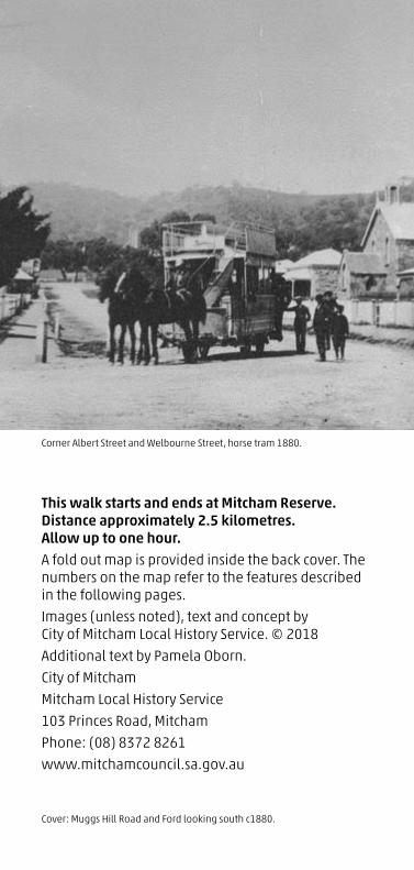
Corner Albert Street and Welbourne Street, horse tram 1880.
This walk starts and ends at Mitcham Reserve. Distance approximately 2.5 kilometres. Allow up to one hour. A fold out map is provided inside the back cover. The numbers on the map refer to the features described in the following pages.
Images (unless noted), text and concept by City of Mitcham Local History Service. © 2018
Additional text by Pamela Oborn.
City of Mitcham
Mitcham Local History Service
103 Princes Road, Mitcham
Phone: (08) 8372 8261
www.mitchamcouncil.sa.gov.au
Cover: Muggs Hill Road and Ford looking south c1880.

1
Before the first European colonists settled in 1836, Brownhill Creek Reserve was a culturally significant territory for Kaurna people. It functioned as a seasonal camping and corroboree ground, an important water resource, a hunting and fishing ground, a rock painting site, and as a supply for crafting materials. Mitcham Reserve was called ‘Wirraparinga’ meaning creek and scrub place. The traditional owners of Brownhill Creek also might have applied firestick farming methods on their land to refresh the vegetation and invite more wild animals. Several accounts of the early colonists state that the Brownhill Creek area was home for about 150 Aboriginal people.
The first contact between Aboriginal and European people in the Brownhill Creek area occurred in 1831 when Captain Collet Barker and his group crossed the district during their journey to Mount Lofty. However, it might have happened even earlier as there is an unconfirmed account of a previous contact.
In 1840 the South Australian Company laid out Section 248 as a village, naming it Mitcham after the manager’s home town in Surrey, England. The 134 acres (54 hectares) of foothills land was divided into 103 lots and offered for sale with the boundaries extending from today’s Carrick Hill Drive to west of Muggs Hill Road, and from Blythewood Road to Princes Road. An area of common land straddling Brownhill Creek was set aside as a village green, the Mitcham Reserve.
Around it developed many shops, hotels, coaching stables, churches and schools. Most shopkeepers lived in dwellings attached to their premises, while labourers occupied simple two or three roomed bluestone cottages. The gentry built gracious villas on the slopes around St Michael’s Church, and rich pastoralists and government officials established huge mansions on large estates in the foothills surrounding the village.

Despite suburban expansion around Adelaide in the early 1880s, Mitcham still remained a compact village until after World War 1 when the population and building boom of the 1920s saw surrounding fields and paddocks subdivided and the village gradually absorbed into the greater Adelaide suburban sprawl. Until the advent of large regional shopping centres in the 1950s and 60s the Village remained the main commercial area for the district. It is no longer a village environment as no corner shops still exist.
Since 1975 the village’s simple colonial architecture has been acknowledged by leading heritage bodies, with many of the buildings being individually listed on National Trust, Federal, State and Local Government Heritage Registers.
This walk begins at the Mitcham Memorial Reserve next to the old Keystone Bridge.
2
Mitcham Reserve Keystone Bridge c1890.

3
1 Mitcham Memorial Reserve
This was the original village green, the centre of colonial life in the Village. There have been several bandstands on the Reserve, the earliest dating from the latter part of the 19th century. The present rotunda was built in 1995 and bears a plaque (facing the creek) explaining its relevance as a War Memorial.
2 Keystone Bridge
The Keystone Bridge over Brownhill Creek is probably the district’s best-known landmark. It was built in 1875 by John Prince Jr. It was washed away in a flood during construction and rebuilt and opened in the following year. A new road / bridge (alongside) was built in 1988 and the original ford crossing is between the two. The bridge is on the State Heritage Register.
Proceed north through the reserve to the large monument.
Keystone Bridge Brownhill Creek crossing Mitcham Reserve c1915. (Charles Petts)

4
3 Mitcham Reserve Monument
This monument is the site of the Union Chapel used by all Christian denominations and as a schoolhouse. In 1847 Thomas Mugg, a carpenter with a cockney twang began the school which is now the Mitcham Primary School teaching reading writing and arithmetic. This site was also where the decision was made in 1853 to form the District Council of Mitcham, the first local governing body outside of the City of Adelaide.
4 The Soldiers Memorial Arch
The Memorial Arch at the entrance of the Mitcham Reserve along with the original Memorial bandstand was built in 1929 after WW1 to commemorate those who served in the war. The reserve was also where ANZAC day celebrations were held. The original Memorial bandstand has since been demolished and replaced.
Cross over Norman Walk, north into Sutton Gardens.
Mitcham Reserve memorials, arch, monument and bandstand 1953.

5
5 Sutton Gardens
This small park opposite High Street was named after Charles Sutton a former Mayor of Mitcham. It was originally the site of ‘Jerusalem’, a large stone house built in 1844 for the Reverend Thomas Playford - namesake and forebear of two South Australian premiers. Extensive gardens, a large well, stables, coach-house and a stone winery occupied the acre block, while a horse paddock and vineyard extended westwards down to the Baptist Church in Albert Street.
Continue on to the bus stop ahead of you on Albert Street (see horse tram interpretive sign). Trams began in Mitcham in 1879 first by horse and then electric in 1911. The tram line closed in 1958 and was replaced by buses. The Terminus was about where the present bus stop is currently located.
Albert Street
This, the main street of the Village, was named for Queen Victoria’s consort, Prince Albert. They married in 1840, the year the Village was laid out.
Playford’s house - Jerusalem c1840s. (SLSA B35304)

6
6 41 Albert Street - Old Mitcham Hotel
Looking across Albert Street to the north east is The Old Mitcham Hotel, built in 1869 originally with a single storey, a second was added in 1879. It operated as a licensed hotel until 1909 when its liquor license was not renewed due to the influence of the Temperance Movement. The building reopened as a Temperance Hotel selling light refreshments, general goods and accommodation, but no alcohol. The hotel was reputed to be a most popular resort with visitors to the Brownhill Creek Park. It had 15 rooms, including three guest rooms. In later years it was a betting shop, boarding house and flats. During restoration in 2012 the original sign writing was discovered on the façade. It is now a private residence. The Old Mitcham Hotel has often been confused with The Brownhill Creek Inn owned by Henry Taylor, which was situated next door to the east of the present building from 1850-1864.
Old Mitcham Hotel c1883.

7
7 35 Albert Street - Harris Greengrocer
On the corner of Albert and High Streets, three generations of the Harris family lived and worked in this former greengrocery store. The door on the corner led into the small shop, while the door to the right was the entrance to the family home. The Harris family grew vegetables in a paddock at the rear of the shop.
Cross over Albert Street and walk north up to the corner of High and Maitland Streets.
8 Corner High Street and Maitland Street - Newey’s Stables
Thomas Newey ran a horse coach service to Adelaide seven times a day and these former stables were built in 1872 to accommodate his team of horses and wagons. When horse-drawn trams were introduced to Mitcham in 1879 private coach services like his were no longer needed. In 1955 the building became the home of the 1st Torrens Park Scout Group.
Now walk back down High Street towards Albert Street and stop at the Edinburgh Hotel.
Newey’s Stables, 1st Torrens Scouts c1950.

8
9 7 High Street - Edinburgh Hotel
The Edinburgh Hotel has had a continuous license since 1869. It was originally just the small centre section with the southern wing added sometime during the next ten years and the mirror-image northern wing added in 1914. Early hotels were used as community meeting places and even to hold inquests.
10 Western corner Albert Street and High Street - Edinburgh Cellars
For 120 years this old shop, built for James and Janet Gardiner c1853, served the needs of the community as a general store selling groceries, sweets, crockery and all sorts of kitchen utensils. Like others in the Village, the shop consisted of one small room, with the rest of the building being used as a residence. During the 1950s some of the interior walls were removed and alterations made to the doors and windows. The Mitcham Village Art and Crafts centre occupied the building for 17 years until a disastrous arson attack in February 1991 reduced the building to a burnt out shell. It was rebuilt and opened the following December as the Edinburgh Hotel’s bottle shop.
Walk west down along Albert Street.
Original Edinburgh Inn c1800s.
9
11 27 Albert Street - House
This house was owned and built by quarry owner Mr Anderson from local stone and is held in high regard architecturally being on both the State Heritage Register and the National Estate Register. Quarrying was an important early industry in the nearby hills employing hundreds of people.
12 23 Albert Street - Cobbler’s Cottage
It is believed that this cottage dates back to the 1860s making it one of the oldest cottages in the whole district. Mr Watters a bootmaker ran his business here in the early 1900s and his shoes and boots would have all been made by hand.
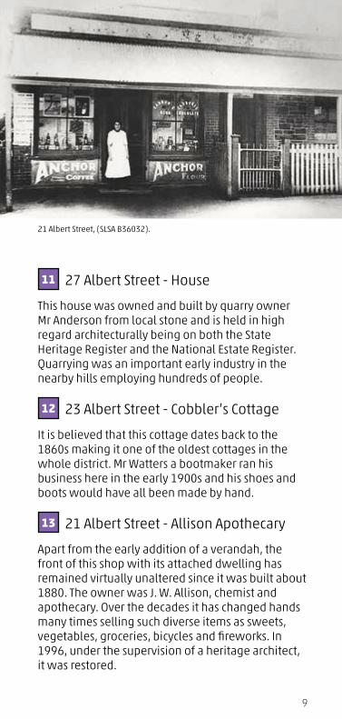
13 21 Albert Street - Allison Apothecary
Apart from the early addition of a verandah, the front of this shop with its attached dwelling has remained virtually unaltered since it was built about 1880. The owner was J. W. Allison, chemist and apothecary. Over the decades it has changed hands many times selling such diverse items as sweets, vegetables, groceries, bicycles and fireworks. In 1996, under the supervision of a heritage architect, it was restored.
21 Albert Street, (SLSA B36032).

10
Mitcham Baptist Church c1900s.
14 18 and 10-16 Albert Street - Baptist Church and Cottages
Looking across the road is a small Baptist church built in 1858 and extended in 1908. The original structure is now hidden behind the later additions. The front porch was demolished and a new façade built in 1973. The simple bluestone modest workers cottage next door presently used as the Church Office dates back to the 1860s. Note the multi-paned windows, common in early Victorian cottages as glass wasn’t strong enough to be manufactured in large panes.
Continue down Albert Street and turn right into Welbourne Street heading north.
15 13 Welbourne Street - Old Bakery
While this shop served as a general store, a thriving bakery operated from the rear of these premises for over 60 years. Bread was delivered all over Adelaide, under government contract to the military barracks, the Goal and Adelaide Hospital. Remnants of the old brick ovens are still there. During 1997-1998 the old shop was restored to its former appearance. The extra residential accommodation on the southern side of the shop was probably added early in the twentieth century.

11
Welbourne Street
Named after Thomas Welbourne, a cooper making wooden wine and beer barrels, who lived in the street. It has two previous names, Institute Road and The Road to Unley. It was originally half its width and became Welbourne Street when it was extended and widen with the introduction of the electric trams. None of the first timber and corrugated iron buildings on the eastern side remain today.
16 7 Welbourne Street - Tram Pole
This is the last remaining steel and cast iron tram pole that was used to carry the wires and electricity which powered the trams operating between Adelaide and Mitcham from 1911-1958.
Continue along Welbourne Street and turn right into Princes Road.
17 90 Princes Road - First Supermarket
This small shop was the first supermarket in South Australia established by the Robins Brothers in the early 1950s. Their father operated a grocer shop at 107 Princes Road behind you across on the corner.
Welbourne Street, electric tram and poles 1900.

12

13

14
18 115 Princes Road - Old Conquest Butcher
Cross Princes Road heading east to the old Conquest Butcher Shop. This was a very busy shop, previously operated by Fritz Conquest, married to one of the Playfords and subsequently operated by the Manuel family.
Walk back west along Princes Road to the corner of Torrens Road.
19 107 Princes Road, corner Torrens Road - Shop and House
Many different shop owners have run small businesses here whilst living with their families in the attached residence. It is believed that local stone mason John Bradley built this around 1895. Although the shopfront and veranda over the footpath have been altered over time, the building retains much of the character of a late nineteenth century shop.
Cross over Torrens Road to the Mitcham Cultural Village.
Conquest Butcher Shop c1893.

15
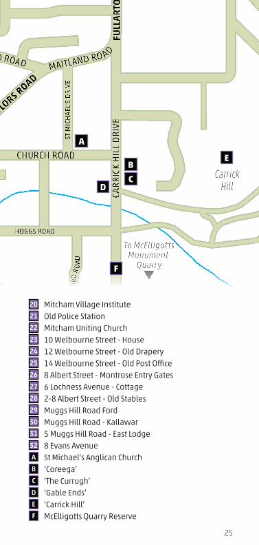
20 Mitcham Village Institute
Built in 1870 the Mitcham Village Institute functioned as school and community hall until 1879. After the school was relocated to Lower Mitcham, Council used it for offices for the next thirty years and as a local library until 1966. It was the centre of the social life of the district with numerous balls, fetes, bridge parties, concerts and patriotic celebrations held there. It was also used as a picture theatre in the 1950s. Money to maintain the Institute was always a problem and in 1960 it was finally transferred to the Mitcham Council. The decision to restore rather than demolish the building was taken in 1993 and the unsightly additions that were made to the front facade in the 1970s were demolished and the building restored. This fine old heritage building is now part of the Mitcham Cultural Village.
Mitcham Village Institute c1880.

16
21 Old Police Station
Next door is the former Mitcham Police Station, built in 1892 and operated until 1967. It contained a charge room, living room, bedroom and kitchen. The freestanding double police cells at the back of the building were short term holding cells. The State Emergency Services operated here from 1973 – 2003 and is now the Mitcham Heritage Research Centre, part of Mitcham Council’s community facilities.
22 Mitcham Uniting Church
Next door and to the rear is the old Mitcham Methodist Church built in 1882, (now part of the Uniting Church) the first Methodist Church in the village area, reflecting the diversity and expansion of religious denominations in the district.
Cross over Princes Road and walk up the western side of Welbourne Street.
23 10 Welbourne Street - House
This fine bluestone house built in the 1870s was once the manse (Minister’s residence) for the Baptist Church in Albert Street.
Old Mitcham Police Station c1900.

17
24 12 Welbourne Street - Old Drapery
For over a hundred years this typical shop and attached residence was the local drapery store where Thwaite’s Menswear began business in 1894. From 1919 -1938 Enoch Jeanes sold drapery, clothing and shoes here, followed by Colin Friend till the early 1970s. It also severed as a small Post Office agency. It is now Stamps Restaurant.
25 14 Welbourne Street, corner Lochness Avenue - Old Post Office
Built in 1883 as the Mitcham Post Office with a front postal office, telegraph lobby and living accommodation for the postmaster. Post Offices were a very important part of the community as they were the only way of staying in touch with family back home in the UK. Telegrams were received and delivered around the district by local lads on bikes from here. The Post Office closed in 1965 and moved to larger premises on Belair Road, Kingswood. A small Post Office agency was transferred to the shop next door to serve the locals. It is now a private home.
Old Mitcham Post Office c1900.

18
Look south across Albert Street to the large gates.
26 8 Albert Street - Montrose Entry Gates
The gates at the end of Welbourne Street are the original front entrance to the Prince family estate (now part of Scotch College). George Prince was a wealthy crockery merchant and the original house behind these gates ‘Montrose’ was built in 1849. It was badly damaged by flood in 1897 and an earthquake 1902 and was demolished in 1908. A new house ‘Kallawar’ was built a year later. Between the gates and the Baptist Church in Albert Street are four attached cottages built by George for his servants. They, like the main house, are all now part of Scotch College Junior School Campus.
Walk west down the right side of Lochness Avenue.
27 6 Lochness Avenue - Cottage
One of the earliest cottages in Mitcham built by Seth Fisher in 1860 with two single front brick wall rooms on land purchased from Elizabeth Bailey who owned all the land bounded by Princes Road, Welbourne Street, Albert Street and Ballogie Road. The next owner Hannah Gilpin built the higher section behind it.
Montrose c1900 (SLSA B36179).

19
Cross over to the corner of Muggs Hill Road.
28 2-8 Albert Street - Old Stables
The old building on the corner of Muggs Hill Road built in the late 1840s, was the Coach House and Stables for both the ‘Montrose’ and ‘Kallawar’ houses, owned by the Prince family on their estate.
Walk south up Muggs Hill Road to the Ford.
29 Muggs Hill Road Ford
Muggs Hill Road was the only road out of Mitcham heading south to the government farm at Belair. In the early days of the Colony this ford provided one of the few points where the Brownhill Creek could be crossed by travellers going up into the hills, particularly timber cutters with their cumbersome bullock teams. Flash floods have led to several people drowning whilst attempting to cross the ford following heavy rain in the catchment areas around Crafers. The road was named after Thomas Mugg, the first school teacher, who lived in a cottage which once stood at the top of the hill.
Albert Street looking east c1910. (SLSA B28348)

20
30 Muggs Hill Road - Kallawar
Next pass the ford is ‘Kallawar’ a federation style mansion built in 1908 for Lloyd Prince after the original house ‘Montrose’ owned by his father George was demolished. There was a beautiful garden, fruit trees and stone outbuildings for stables, carriages, laundry and a dairy. Some of the outbuildings can still be seen. It is now part of Scotch College Junior School Campus.
Continue south along Muggs Hill Road to the corner of Evans Avenue and look across the road.
31 5 Muggs Hill Road - East Lodge
East Lodge was formerly the gatehouse leading into the vast ‘Torrens Park Estate’ (now Scotch College). The northern rooms date from the 1860s and the others were added in the 1880s. The Lodge was home of the head gardener Charles Evans for nearly 30 years from the early 1880s during the ownership of Robert Barr Smith. Evans Avenue is named after him.
Torrens Park Estate (at the rear of East lodge) was built for Robert Torrens in 1853 and home of prominent South Australian men and women including Sir Walter Hughes and Robert Barr Smith. The Barr Smith family, wealthy pastoralists
East Lodge, Torrens Park Estate entrance 1880s.

21
were well known for their entertaining and gala functions. A theatre was added to the mansion in 1884. The Barr Smiths allowed their home to be used as a convalescent home for soldiers during WW1. The now Scotch College was founded in 1919.
Walk down Evans Avenue towards your walk starting point at the Mitcham Memorial Reserve.
32 8 Evans Avenue
This is the site of the first hotel in Mitcham, The Black Swan, built and opened in 1846 opposite the Village Green. It was run by William Dawbiney until it closed in 1850.
You have now finished you walking tour of Mitcham Village.While you are in this area you may like to visit some other places of interest to the east of the Mitcham Village Reserve in Upper Mitcham, either by walking or by car as it is a fairly steep incline up Carrick Hill Drive.
Corner Church Road and St Michael’s Road
A St Michael’s Anglican Church
This historic Anglican Church was built in 1852, one of the oldest in Adelaide. Constructed of local stone, with an imposing tower, it is set in large grounds amidst towering River Red Gums in a quiet leafy suburb and is on the National Estate Register. Within twelve years of its opening the building was extended some seven metres further south, thus creating an almost square church. The priest’s vestry was added in 1871, and a choir vestry in 1899. The Church features many beautiful stained glass windows and an historic Bishop & Son organ.

22
Carrick Hill Drive
B ‘Coreega’
Almost opposite Church Road on Carrick Hill Drive are the gates leading into ‘Coreega’ (now mostly hidden from view by houses built in its former garden). This was the childhood home of Nobel Prize winner Lord Florey, the co-discoverer of penicillin.
C ‘The Currugh’
Three doors further south at number 26 is a large bluestone home originally named ‘The Currugh’. In 1910 it was purchased by the Orphan Home, Adelaide, Inc. founded in 1860 by Mrs Julia Farr and ladies of the Church of England. For over 70 years ‘Farr House’ was home for up to 30 girls who were either orphans or from broken homes.
D ‘Gable Ends’
On the opposite side of the road at number 27 is another charming old colonial home, believed to have been built in the 1850s.
Carrick Hill.

23
E ‘Carrick Hill’
This grand Tudor manor house set in I00 acres (40 hectares) of gardens and bushland, was built in the late 1930s for Sir Edward Hayward and his first wife, the former Ursula Barr Smith. Following their deaths the property, together with its priceless art and sculpture collection, was bequeathed to the people of South Australia. It is on the State Heritage Register. For Carrick Hill opening times and tours visit. www.carrickhill.sa.gov.au
F McElligotts Quarry Reserve
The car park at the top of Carrick Hill Drive offers magnificent views over the City and suburbs of Adelaide. McElligotts Quarry was one of the major quarry sites in the district and operated from 1850 -1934. It produced crushed rocks for road construction in the district and large stone blocks for the outer harbour breakwater. It was later used as a rubbish dump by Mitcham Council from 1957 -1985, before being transformed into the current reserve.
McElligotts Quarry c1926.

24
CARR
ICK
HIL
L D
RIVE
MU
GG
S H
ILL
ROAD NORMAN WALK
BRADY STREET
ALBERT STREETLOCHNESS AVENUE
WEL
BOU
RNE
STRE
ET
MAITLAND ROAD
HIG
H S
TREE
T
BLYTHEWOOD ROAD
OLD
BEL
AIR R
OAD
TAYLORS ROAD
BR
OW
NH
ILL
CREE
K R
OA
DLEONARD TE RRACE
FULL
AR
TON
RO
AD
ST M
ICH
AEL’
S D
RIVE
PRINCES ROAD
EVANS AVENUE
CHURCH ROAD
MAITLAND RO AD
OLD BELAIR ROAD
GIL
PIN
LAN
E
ROSE
LAN
E
CUTH
BERT
PLAY
FORD
RO
AD
HOGGS ROAD
To McElligottsMonument
Quarry
CarrickHill
SuttonGarden
MitchamReserve
Legend1 Mitcham Memorial Reserve2 Keystone Bridge3 Mitcham Reserve Monument4 The Soldiers Memorial Arch5 Sutton Gardens6 41 Albert Street - Old Mitcham Hotel7 35 Albert Street - Harris Greengrocer8 Corner High and Maitland Streets - Newey’s Stables9 7 High Street - Edinburgh Hotel
10 Corner Albert and High Streets - Edinburgh Cellars11 27 Albert Street - House12 23 Albert Street - Cobbler’s Cottage13 21 Albert Street - Allison Apothecary14 18 & 10-16 Albert Street - Baptist Church and Cottages15 13 Welbourne Street - Old Bakery16 7 Welbourne Street - Tram Pole17 90 Princes Road - First Supermarket18 115 Princes Road - Old Conquest Butcher19 107 Princes Road - Shop and House
3 4
5
2
1
7
8
610111213
1524
25
26
27
28
30
31
32
29
23
14
16
17
1819202122
9
25
CARR
ICK
HIL
L D
RIVE
MU
GG
S H
ILL
ROAD NORMAN WALK
BRADY STREET
ALBERT STREETLOCHNESS AVENUE
WEL
BOU
RNE
STRE
ET
MAITLAND ROAD
HIG
H S
TREE
T
BLYTHEWOOD ROAD
OLD
BEL
AIR R
OAD
TAYLORS ROAD
BR
OW
NH
ILL
CREE
K R
OA
DLEONARD TE RRACE
FULL
AR
TON
RO
AD
ST M
ICH
AEL’
S D
RIVE
PRINCES ROAD
EVANS AVENUE
CHURCH ROAD
MAITLAND RO AD
OLD BELAIR ROAD
GIL
PIN
LAN
E
ROSE
LAN
E
CUTH
BERT
PLAY
FORD
RO
AD
HOGGS ROAD
To McElligottsMonument
Quarry
CarrickHill
SuttonGarden
MitchamReserve
20 Mitcham Village Institute21 Old Police Station22 Mitcham Uniting Church23 10 Welbourne Street - House24 12 Welbourne Street - Old Drapery25 14 Welbourne Street - Old Post Office26 8 Albert Street - Montrose Entry Gates27 6 Lochness Avenue - Cottage28 2-8 Albert Street - Old Stables29 Muggs Hill Road Ford30 Muggs Hill Road - Kallawar31 5 Muggs Hill Road - East Lodge32 8 Evans AvenueA St Michael’s Anglican ChurchB ‘Coreega’C ‘The Currugh’D ‘Gable Ends’E ‘Carrick Hill’F McElligotts Quarry Reserve
A
CD
E
F
B

Mitcham Village Historical Walk
Mitcham Village