Mitcham Sub Area Neighbourhoods
25
Mitcham Sub Area Neighbourhoods 1 7 Church Road DRAFT
Transcript of Mitcham Sub Area Neighbourhoods

Mitcham Sub Area Neighbourhoods
1
7 Church RoadDRAFT

2
Origins and General CharacterChurch Road is a residential neighbourhood located to the south of Merantun Way on either side of Church Road. The southern boundary is delineated by the Tramlink and the west by the Wandle River. The area is characterised by pockets of early 20th century interspersed amongst predominantly post-war medium intensity suburban development.Historically land use was industrial with associated residential however it is now almost entirely residential. To the west beyond Phipps Bridge Road there is a green corridor which is designated as part of The Wandle Valley conservation area adjacent to which there are some locally and statutory listed buildings. This linear park forms part of a link between Colliers Wood to Morden Hall. Obtrusive features are the pylons which run through the neighbourhood.
The area had long been a marshy uninhabited location, it first became a site for industry due to its proximity to the River Wandle. There is evidence of water milling around the river as early as the 13th century. However there was little development until the late 18th century. Textile and printing
Church Road Local Neighbourhood
Merton borough character study: 7 Church Road Local Neighbourhood
industry was attracted by the river which was a useful resource for these industries in the powering of machinery and the manufacture process. Earliest development focused on industrial activity with the industrial sites interspersed with large houses such as Wandle House and small terraces of cottages of which there is a remnant on Phipps Bridge Road namely Everetts Terrace. These cottages and the nearby Wandle Villa represent a rare insight into the rural character of the area after the disappearance of the milling industries. The green corridor to the west was once locally known as Bunce’s Meadow, there had been a concentration of industry in this area however the land was acquired by Gilliat Hatfeild. He removed defunct industrial buildings from his estate in the 1870s which enhanced the rural setting to the west of the neighbourhood.
By the 1860s there was a transition into paint and varnish manufacture which continued until the middle of the 20th century. There was a concentration of japan and varnish works to the north and east of the neighbourhood. In addition there were a number of gravel pits which were excavated until the 1920s and which would later become uncontrolled
landfill sites. Streets of small terraced houses began to appear. Houses were developed along Church Road, Belgrave Road and streets which no longer exist today namely Queen’s and Bath Road. This area was known locally as ‘Rocky’ it was later to gain a notorious reputation for crime and slum conditions. In 1926 as a philanthropic gesture Gilliat Hatfeild donated land to the Urban District Council of Mitcham to provide a recreation ground, children’s playground and additional allotments to the north of this cluster of terraced houses.
During the inter-war years the fumes from factories created an unpleasant environment as a result Phipps Bridge became an undesirable place in which to live. In addition a large refuse incinerator was built on Homewood Road known locally as ‘The Dust’ as it was said to blow a fine dust overhouses down wind. When the incinerator was demolished in the 1940s, Bunce’s meadow was used by Mitcham Corporation as a site to deposit the waste. Bunce’s Meadow area was bequeathed to the National Trust in 1941 following the death of Gilliat Hatfeild; it was later to become an open wildlife habitat of scrubland and today is a popular green route for
Mock ruin folly adjacent to Everetts Terrace on Phipps Bridge Road
3
Church Road Local Neighbourhood
Merton borough character study: 7 Church Road Local Neighbourhood
walkers and cyclists between Colliers Wood and Morden.
In the 1930s new residential development intensified to the south east as grid iron terraces appeared such as Collingwood Road and Bank Avenue. Housing development also began around Haslemere Avenue and New Close which was completed post WWII. The large houses gradually partitioned off land to provide extensive areas of allotment gardens between two world wars.
A major incident was the explosion at W J Bush’s distillery works in 1933 which caused the roofs to be stripped from dozens of houses around Belgrave Road, some houses were repaired while others were demolished and their sites were either left vacant or redeveloped for industry. By 1939 much of the remaining housing in the surrounding area was in disrepair and had already been identified for slum clearance. In the post war period there was a huge demand for housing. There was clearance of slum housing and landfill sites, in addition large houses such Homefield House were redeveloped.
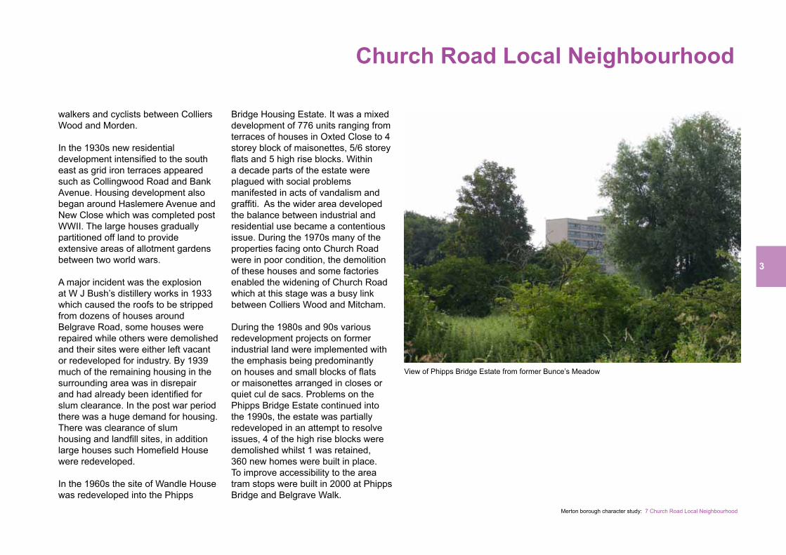
In the 1960s the site of Wandle House was redeveloped into the Phipps
Bridge Housing Estate. It was a mixed development of 776 units ranging from terraces of houses in Oxted Close to 4 storey block of maisonettes, 5/6 storey flats and 5 high rise blocks. Within a decade parts of the estate were plagued with social problems manifested in acts of vandalism and graffiti. As the wider area developed the balance between industrial and residential use became a contentious issue. During the 1970s many of the properties facing onto Church Road were in poor condition, the demolition of these houses and some factories enabled the widening of Church Road which at this stage was a busy link between Colliers Wood and Mitcham.
During the 1980s and 90s variousredevelopment projects on former industrial land were implemented with the emphasis being predominantly on houses and small blocks of flats or maisonettes arranged in closes or quiet cul de sacs. Problems on the Phipps Bridge Estate continued into the 1990s, the estate was partially redeveloped in an attempt to resolve issues, 4 of the high rise blocks were demolished whilst 1 was retained, 360 new homes were built in place. To improve accessibility to the area tram stops were built in 2000 at Phipps Bridge and Belgrave Walk.
View of Phipps Bridge Estate from former Bunce’s Meadow
4
Church Road Local Neighbourhood
Merton borough character study: 7 Church Road Local Neighbourhood
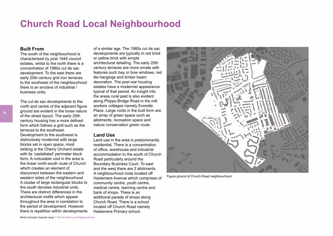
Built FromThe south of the neighbourhood is characterised by post 1945 council estates, whilst to the north there is a concentration of 1980s cul de sac development. To the east there are early 20th century grid iron terraces.to the southeast of the neighbourhood there is an enclave of industrial / business units.
The cul de sac developments to the north and centre of the adjacent figure ground are evident in the loose nature of the street layout. The early 20th century housing has a more defined form which follows a grid such as the terraces to the southeast. Development to the southwest is distinctively modernist with large blocks set in open space, most striking is the Cherry Orchard estate with its ‘castellated’ perimeter block form. A noticeable void in the area is the linear north-south route of Church which creates an element of disconnect between the eastern and western sides of the neighbourhood. A cluster of large rectangular blocks to the south denotes industrial units.There are distinct differences in the architectural motifs which appear throughout the area in correlation to the period of development. However there is repetition within developments
of a similar age. The 1980s cul de sac developments are typically in red brick or yellow brick with simple architectural detailing. The early 20th century terraces are more ornate with features such bay or bow windows, red tile hangings and timber beam decoration. The post war housing estates have a modernist appearance typical of that period. An insight into the areas rural past is also evident along Phipps Bridge Road in the mill workers cottages namely Everetts Place. Large voids in the built form are an array of green space such as allotments, recreation space and nature conservation green route.
Land UseLand use in the area is predominantly residential. There is a concentration of office, warehouse and industrial accommodation to the south of Church Road particularly around the Boundary Business Court. To east and the west there are 2 allotments. A neighbourhood node located off Haslemere Avenue which comprises of community centre, youth centre, medical centre, learning centre and bank of shops. There is an additional parade of shops along Church Road. There is a school located off Church Road namely Haslemere Primary school.
Figure ground of Church Road neighbourhood

5
Church Road Local Neighbourhood
Merton borough character study: 7 Church Road Local Neighbourhood
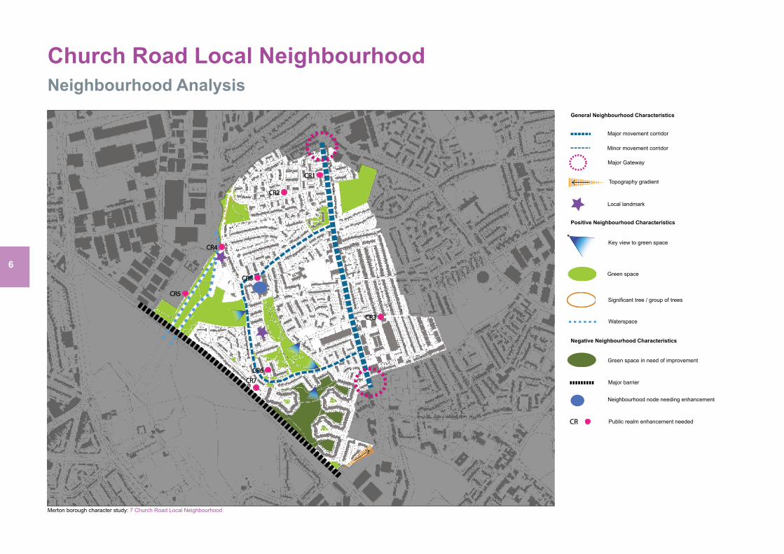
MovementThe main route through the neighbourhood is a London distributor road namely Church Road, it is a busy traffic corridor which links Colliers Wood to Mitcham. Haslemere Avenue running into Phipps Bridge Road is local distributor road which feeds into the residential areas to the west of the neighbourhood. Permeability is hindered in places, for example a pocket of housing to the north west can only be accessed via Liberty Avenue, in addition the cul de sac layout of houses make legibility difficult. The tramlink runs along the southern boundary with stops at Phipps Bridge and Belgrave Road which connects the area to Wimbledon and Croydon. A cycle route runs along Phipps Bridge Road and parts of Church Road, there are future plans to extend the route along Church Road to link into the Cycle Superhighway (CS7). A number of bus routes also run through the neighbourhood.
Open SpaceTo the west of the neighbourhood there is a green corridor which runs alongside the River Wandle linking Colliers Wood to Morden Hall Park. The natural landscaping and ecological diversity of the area
combine to make it an important passive recreational resource. Adjacent to which are Phipps Bridge allotments and the surrounding wooded areas which gives the west edge of the neighbourhood a leafy characteristic. In proximity to Reynolds Close are the Western Road allotments. Central to the Phipps Bridge Estate is Rock Terrace Recreation Ground which includes toddler play area and teen recreation area. Enclosed by the Cherry Tree Estate is another open space.
River Wandle
6
Church Road Local Neighbourhood
Merton borough character study: 7 Church Road Local Neighbourhood
Neighbourhood Analysis
CR3
CR1
CR2
CR4
CR5
CR6CR7
CR8
General Neighbourhood Characteristics
Major Gateway
Key view to green space
Green space
Major barrier
Significant tree / group of trees
Public realm enhancement neededCR
Major movement corridor
Minor movement corridor
Waterspace
Local landmark
Green space in need of improvement
Neighbourhood node needing enhancement
Topography gradient
Positive Neighbourhood Characteristics
Negative Neighbourhood Characteristics

7
Church Road Local Neighbourhood
Merton borough character study: 7 Church Road Local Neighbourhood
Heritage Assets
Heritage map to be added at later stage
8
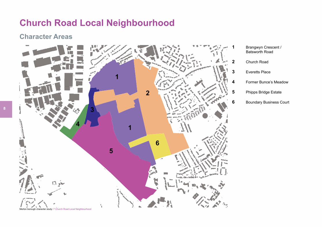
Church Road Local NeighbourhoodCharacter Areas
Merton borough character study: 7 Church Road Local Neighbourhood
1
1
2
3
4
56
1 Brangwyn Crescent / Batsworth Road
2 Church Road
3 Everetts Place
4 Former Bunce’s Meadow
5 Phipps Bridge Estate
6 Boundary Business Court

9
Church Road Local Neighbourhood
Merton borough character study: 7 Church Road Local Neighbourhood
Character Areas Assessment, Issues and Guidance
10
Merton borough character study: 7 Church Road Local Neighbourhood
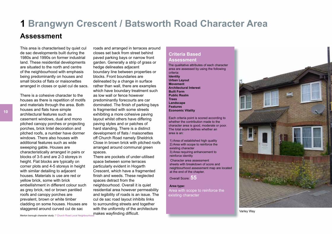
1 Brangwyn Crescent / Batsworth Road Character AreaAssessment This area is characterised by quiet cul de sac developments built during the 1980s and 1990s on former industrial land. These residential developments are situated to the north and centre of the neighbourhood with emphasis being predominantly on houses and small blocks of flats or maisonettes arranged in closes or quiet cul de sacs.
There is a cohesive character to the houses as there is repetition of motifs and materials through the area. Both houses and flats have simple architectural features such as casement windows, dual and mono pitched canopy porches or projecting porches, brick lintel decoration and pitched roofs, a number have dormer windows. There also houses with additional features such as wide sweeping gable. Houses are characteristically arranged in pairs or blocks of 3-5 and are 2-3 storeys in height. Flat blocks are typically on corner plots and 4-5 storeys in height with similar detailing to adjacent houses. Materials is use are red or yellow brick, some with brick embellishment in different colour such as grey brick, red or brown pantiled roofs and canopy porches are prevalent, brown or white timber cladding on some houses. Houses are staggered around curved cul de sac
roads and arranged in terraces around closes set back from street behind paved parking bays or narrow front garden. Generally a strip of grass or hedge delineates adjacent boundary line between properties or blocks. Front boundaries are delineated by a change in surface rather than wall, there are examples which have boundary treatment such as low wall or fence however predominantly forecourts are car dominated. The finish of parking bays is fragmented with some streets exhibiting a more cohesive paving layout whilst others have differing paving styles and or patches of hard standing. There is a distinct development of flats / maisonettes off Church Road namely Sheldrick Close in brown brick with pitched roofs arranged around communal green spaces.There are pockets of under-utilised space between some terraces particularly evident in Hogarth Crescent, which have a fragmented finish and weeds. These neglected spaces detract from the neighbourhood. Overall it is quiet residential area however permeability and legibility of roads is an issue. The cul de sac road layout inhibits links to surrounding streets and together with the uniformity of the architecture makes wayfinding difficult.
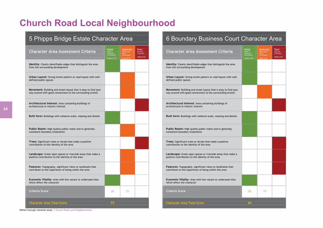
Criteria Based Assessment The qualitative attributes of each character area are assessed by using the following criteria: Identity Urban Layout Movement Architectural Interest Built Form Public Realm Trees Landscape Features Economic Vitality Each criteria point is scored according to whether the contribution made to the character area is good, moderate or poor. The total score defines whether an area is an: 1) Area of established high quality 2) Area with scope to reinforce the existing character 3) Area requiring enhancement to reinforce identity Character area assessment sheets with breakdown of score and neighbourhood assessment map are located at the end of the chapter.
Overall Score: 55 Area type: Area with scope to reinforce the existing character
Varley Way
11
Merton borough character study: 7 Church Road Local Neighbourhood
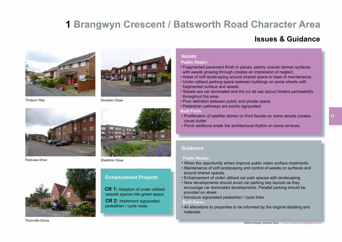
1 Brangwyn Crescent / Batsworth Road Character Area Issues & Guidance
Issues Public Realm: • Fragmented pavement finish in places, patchy uneven tarmac surfaces with weeds growing through creates an impression of neglect. • Areas of soft landscaping around shared space in need of maintenance. • Under utilised parking space between buildings on some streets with fragmented surface and weeds. • Streets are car dominated and the cul de sac layout hinders permeability throughout the area. • Poor definition between public and private space. • Pedestrian pathways are poorly signposted. Built Form: • Proliferation of satellite dishes on front facade on some streets creates visual clutter. • Porch additions break the architectural rhythm on some terraces.
Guidance Public Realm: • When the opportunity arises improve public realm surface treatments. • Maintenance of soft landscaping and control of weeds on surfaces and around shared spaces. • Enhancement of under utilised car park spaces with landscaping. • New developments should avoid car parking bay layouts as they encourage car dominated developments. Parallel parking should be provided on street. • Introduce signposted pedestrian / cycle links. Built Form: • All alterations to properties to be informed by the original detailing and materials.
Goodwin CloseThoburn Way
Sheldrick CloseParkview Drive
Thornville Grove
Enhancement Projects CR 1: Adaption of under utilised carpark spaces into green space
CR 2: Implement signposted pedestrian / cycle route.
12
Merton borough character study: 7 Church Road Local Neighbourhood
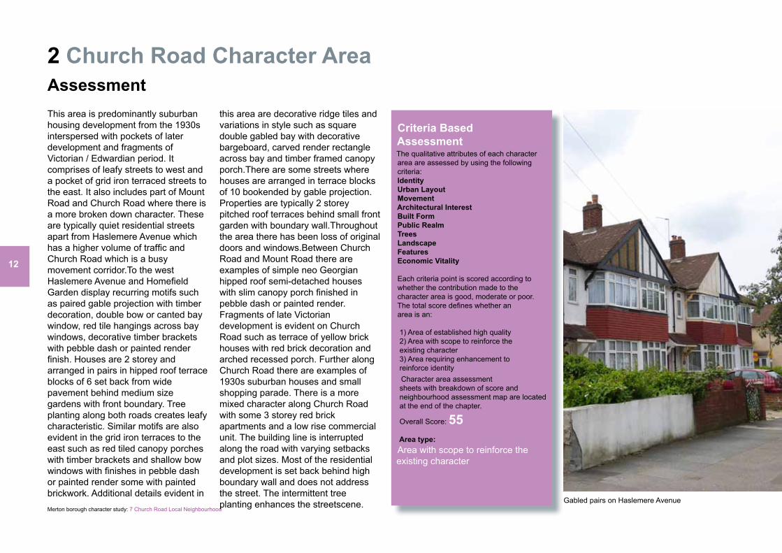
2 Church Road Character AreaAssessment
Criteria Based Assessment The qualitative attributes of each character area are assessed by using the following criteria: Identity Urban Layout Movement Architectural Interest Built Form Public Realm Trees Landscape Features Economic Vitality Each criteria point is scored according to whether the contribution made to the character area is good, moderate or poor. The total score defines whether an area is an: 1) Area of established high quality 2) Area with scope to reinforce the existing character 3) Area requiring enhancement to reinforce identity Character area assessment sheets with breakdown of score and neighbourhood assessment map are located at the end of the chapter.
Overall Score: 55 Area type: Area with scope to reinforce the existing character
This area is predominantly suburban housing development from the 1930s interspersed with pockets of later development and fragments of Victorian / Edwardian period. It comprises of leafy streets to west and a pocket of grid iron terraced streets to the east. It also includes part of Mount Road and Church Road where there is a more broken down character. These are typically quiet residential streets apart from Haslemere Avenue which has a higher volume of traffic and Church Road which is a busy movement corridor.To the west Haslemere Avenue and Homefield Garden display recurring motifs such as paired gable projection with timber decoration, double bow or canted bay window, red tile hangings across bay windows, decorative timber brackets with pebble dash or painted render finish. Houses are 2 storey and arranged in pairs in hipped roof terrace blocks of 6 set back from wide pavement behind medium size gardens with front boundary. Tree planting along both roads creates leafy characteristic. Similar motifs are also evident in the grid iron terraces to the east such as red tiled canopy porches with timber brackets and shallow bow windows with finishes in pebble dash or painted render some with painted brickwork. Additional details evident in
this area are decorative ridge tiles and variations in style such as square double gabled bay with decorative bargeboard, carved render rectangle across bay and timber framed canopy porch.There are some streets where houses are arranged in terrace blocks of 10 bookended by gable projection. Properties are typically 2 storey pitched roof terraces behind small front garden with boundary wall.Throughout the area there has been loss of original doors and windows.Between Church Road and Mount Road there are examples of simple neo Georgian hipped roof semi-detached houses with slim canopy porch finished in pebble dash or painted render. Fragments of late Victorian development is evident on Church Road such as terrace of yellow brick houses with red brick decoration and arched recessed porch. Further along Church Road there are examples of 1930s suburban houses and small shopping parade. There is a more mixed character along Church Road with some 3 storey red brick apartments and a low rise commercial unit. The building line is interrupted along the road with varying setbacks and plot sizes. Most of the residential development is set back behind high boundary wall and does not address the street. The intermittent tree planting enhances the streetscene. Gabled pairs on Haslemere Avenue
13
Merton borough character study: 7 Church Road Local Neighbourhood
2 Church Road Character Area Issues & Guidance
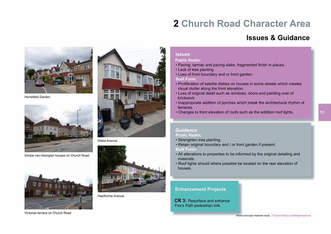
Issues Public Realm: • Paving; tarmac and paving slabs, fragmented finish in places. • Lack of tree planting. • Loss of front boundary and or front garden. Built Form: • Proliferation of satelite dishes on houses in some streets which creates visual clutter along the front elevation. • Loss of original detail such as windows, doors and painting over of brickwork. • Inappropriate addition of porches which break the architectural rhythm of terraces. • Changes to front elevation of roofs such as the addition roof lights.
Guidance Public Realm: • Strenghten tree planting. • Retain original boundary and / or front garden if present. Built Form: • All alterations to properties to be informed by the original detailing and materials. • Roof lights should where possible be located on the rear elevation of houses.
Homefield Garden
Simple neo-Georgian houses on Church Road
Glebe Avenue
Hawthorne Avenue
Victorian terrace on Church Road
Enhancement Projects CR 3: Resurface and enhance Fox’s Path pedestrian link.
14
Merton borough character study: 7 Church Road Local Neighbourhood
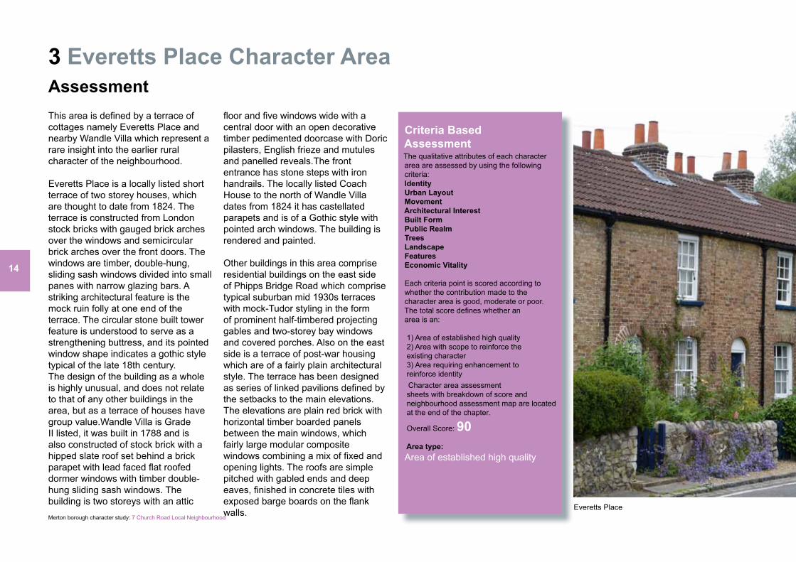
3 Everetts Place Character AreaAssessment
Criteria Based Assessment The qualitative attributes of each character area are assessed by using the following criteria: Identity Urban Layout Movement Architectural Interest Built Form Public Realm Trees Landscape Features Economic Vitality Each criteria point is scored according to whether the contribution made to the character area is good, moderate or poor. The total score defines whether an area is an: 1) Area of established high quality 2) Area with scope to reinforce the existing character 3) Area requiring enhancement to reinforce identity Character area assessment sheets with breakdown of score and neighbourhood assessment map are located at the end of the chapter.
Overall Score: 90 Area type: Area of established high quality
Everetts Place
This area is defined by a terrace of cottages namely Everetts Place and nearby Wandle Villa which represent a rare insight into the earlier rural character of the neighbourhood.
Everetts Place is a locally listed short terrace of two storey houses, which are thought to date from 1824. The terrace is constructed from London stock bricks with gauged brick arches over the windows and semicircular brick arches over the front doors. The windows are timber, double-hung, sliding sash windows divided into small panes with narrow glazing bars. A striking architectural feature is the mock ruin folly at one end of the terrace. The circular stone built tower feature is understood to serve as a strengthening buttress, and its pointed window shape indicates a gothic style typical of the late 18th century.The design of the building as a whole is highly unusual, and does not relate to that of any other buildings in the area, but as a terrace of houses have group value.Wandle Villa is Grade II listed, it was built in 1788 and is also constructed of stock brick with a hipped slate roof set behind a brick parapet with lead faced flat roofed dormer windows with timber double-hung sliding sash windows. The building is two storeys with an attic
floor and five windows wide with a central door with an open decorative timber pedimented doorcase with Doric pilasters, English frieze and mutules and panelled reveals.The front entrance has stone steps with iron handrails. The locally listed Coach House to the north of Wandle Villa dates from 1824 it has castellated parapets and is of a Gothic style with pointed arch windows. The building is rendered and painted.
Other buildings in this area comprise residential buildings on the east side of Phipps Bridge Road which comprise typical suburban mid 1930s terraces with mock-Tudor styling in the form of prominent half-timbered projecting gables and two-storey bay windows and covered porches. Also on the east side is a terrace of post-war housing which are of a fairly plain architectural style. The terrace has been designed as series of linked pavilions defined by the setbacks to the main elevations. The elevations are plain red brick with horizontal timber boarded panels between the main windows, which fairly large modular composite windows combining a mix of fixed and opening lights. The roofs are simple pitched with gabled ends and deep eaves, finished in concrete tiles with exposed barge boards on the flank walls.
15
Merton borough character study: 7 Church Road Local Neighbourhood
3 Everetts Place Character Area Issues & Guidance
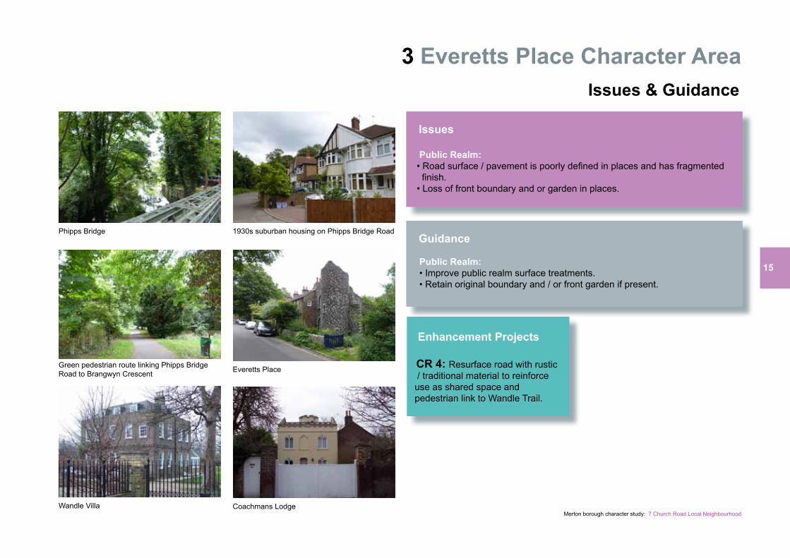
Issues Public Realm: • Road surface / pavement is poorly defined in places and has fragmented finish. • Loss of front boundary and or garden in places.
Guidance Public Realm: • Improve public realm surface treatments. • Retain original boundary and / or front garden if present.
Phipps Bridge
Wandle Villa Coachmans Lodge
Everetts PlaceGreen pedestrian route linking Phipps Bridge Road to Brangwyn Crescent
1930s suburban housing on Phipps Bridge Road
Enhancement Projects CR 4: Resurface road with rustic / traditional material to reinforce use as shared space and pedestrian link to Wandle Trail.
16
Merton borough character study: 7 Church Road Local Neighbourhood
4 Former Bunce’s Meadow Character AreaAssessment
Criteria Based Assessment The qualitative attributes of each character area are assessed by using the following criteria: Identity Urban Layout Movement Architectural Interest Built Form Public Realm Trees Landscape Features Economic Vitality Each criteria point is scored according to whether the contribution made to the character area is good, moderate or poor. The total score defines whether an area is an: 1) Area of established high quality 2) Area with scope to reinforce the existing character 3) Area requiring enhancement to reinforce identity Character area assessment sheets with breakdown of score and neighbourhood assessment map are located at the end of the chapter.
Overall Score: 70 Area type: Area with scope to reinforce the existing character
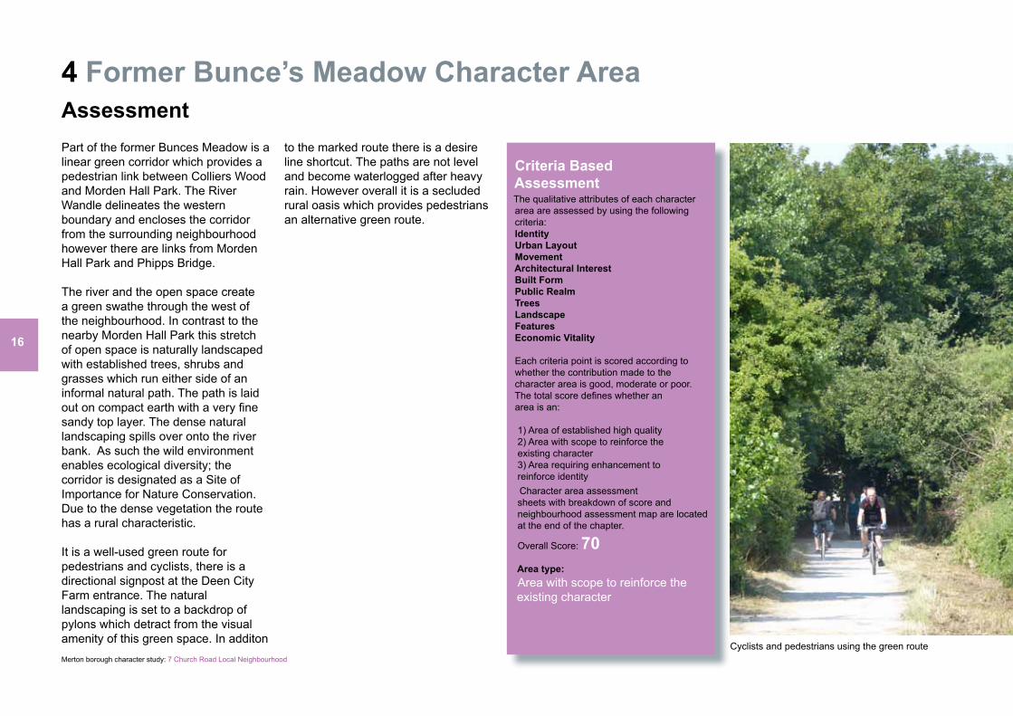
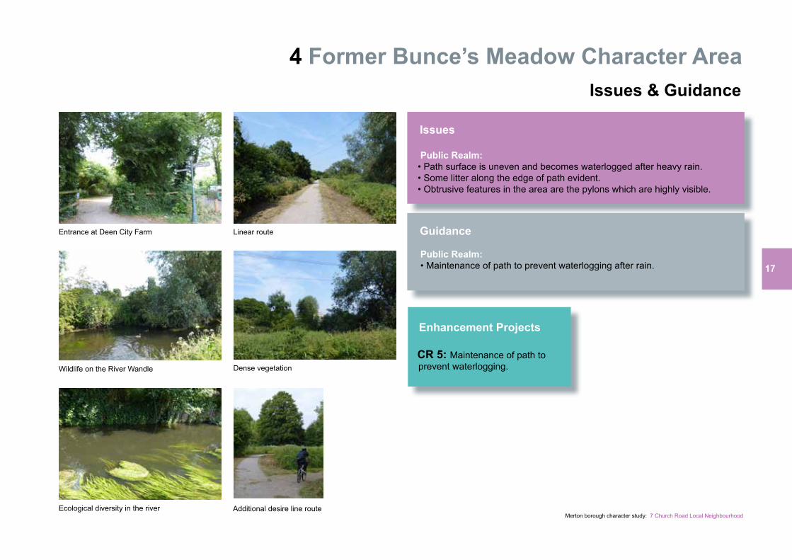
Part of the former Bunces Meadow is a linear green corridor which provides a pedestrian link between Colliers Wood and Morden Hall Park. The River Wandle delineates the western boundary and encloses the corridor from the surrounding neighbourhood however there are links from Morden Hall Park and Phipps Bridge.
The river and the open space create a green swathe through the west of the neighbourhood. In contrast to the nearby Morden Hall Park this stretch of open space is naturally landscaped with established trees, shrubs and grasses which run either side of an informal natural path. The path is laid out on compact earth with a very fine sandy top layer. The dense natural landscaping spills over onto the river bank. As such the wild environment enables ecological diversity; the corridor is designated as a Site of Importance for Nature Conservation. Due to the dense vegetation the route has a rural characteristic.
It is a well-used green route for pedestrians and cyclists, there is a directional signpost at the Deen City Farm entrance. The natural landscaping is set to a backdrop of pylons which detract from the visual amenity of this green space. In additon
to the marked route there is a desire line shortcut. The paths are not level and become waterlogged after heavy rain. However overall it is a secluded rural oasis which provides pedestrians an alternative green route.
Cyclists and pedestrians using the green route
17
Merton borough character study: 7 Church Road Local Neighbourhood
4 Former Bunce’s Meadow Character Area Issues & Guidance
Issues Public Realm: • Path surface is uneven and becomes waterlogged after heavy rain. • Some litter along the edge of path evident. • Obtrusive features in the area are the pylons which are highly visible.
Guidance Public Realm: • Maintenance of path to prevent waterlogging after rain.
Cyclists and pedestrians using the green route
Entrance at Deen City Farm
Wildlife on the River Wandle
Linear route
Dense vegetation
Additional desire line routeEcological diversity in the river
Enhancement Projects CR 5: Maintenance of path to prevent waterlogging.
Merton borough character study: 7 Church Road Local Neighbourhood
5 Phipps Bridge Estate Character AreaAssessment
Criteria Based Assessment The qualitative attributes of each character area are assessed by using the following criteria: Identity Urban Layout Movement Architectural Interest Built Form Public Realm Trees Landscape Features Economic Vitality Each criteria point is scored according to whether the contribution made to the character area is good, moderate or poor. The total score defines whether an area is an: 1) Area of established high quality 2) Area with scope to reinforce the existing character 3) Area requiring enhancement to reinforce identity Character area assessment sheets with breakdown of score and neighbourhood assessment map are located at the end of the chapter.
Overall Score: 55 Area type: Area with scope to reinforce the existing character
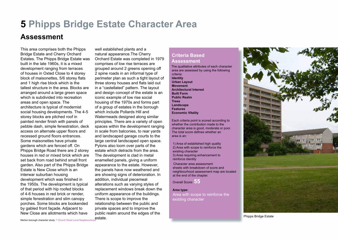
This area comprises both the Phipps Bridge Estate and Cherry Orchard Estates. The Phipps Bridge Estate was built in the late 1960s, it is a mixed development ranging from terraces of houses in Oxted Close to 4 storey block of maisonettes, 5/6 storey flats and 1 high rise block which is the tallest structure in the area. Blocks are arranged around a large green space which is subdivided into recreation areas and open space. The architecture is typical of modernist social housing developments. The 4-5 storey blocks are pitched roof in painted render finish with panels of pebble dash, simple fenestration, deck access on alternate upper floors and recessed ground floors entrances. Some maisonettes have private gardens which are fenced off. On Phipps Bridge Road there are 2 storey houses in red or mixed brick which are set back from road behind small front garden. Also part of the Phipps Bridge Estate is New Close which is an interwar suburban housing development which was finished in the 1950s. The development is typical of that period with hip roofed blocks of 4-6 houses in red brick or render, simple fenestration and slim canopy porches. Some blocks are bookended by gabled front façade. Adjacent to New Close are allotments which have
well established plants and a natural appearance.The Cherry Orchard Estate was completed in 1979 comprises of low rise terraces are grouped around 2 greens opening off 2 spine roads in an informal type of perimeter plan as such a tight layout of three storey houses and flats laid out in a “castellated” pattern. The layout and design concept of the estate is an iconic example of low rise social housing of the 1970s and forms part of a group of estates in the borough which include Pollards Hill and Watermeads designed along similar principles. There are a variety of open spaces within the development ranging in scale from balconies, to rear yards and landscaped garage courts to the large central landscaped open space. Pylons also loom over parts of the estate which detracts from the area. The development is clad in metal enamelled panels, giving a uniform appearance to the estate. However, the panels have now weathered and are showing signs of deterioration. In addition, individual piecemeal alterations such as varying styles of replacement windows break down the uniform appearance of the buildings. There is scope to improve the relationship between the public and private spaces and to improve the public realm around the edges of the estate. Phipps Bridge Estate
Merton borough character study: 7 Church Road Local Neighbourhood
5 Phipps Bridge Estate Character Area Issues & Guidance
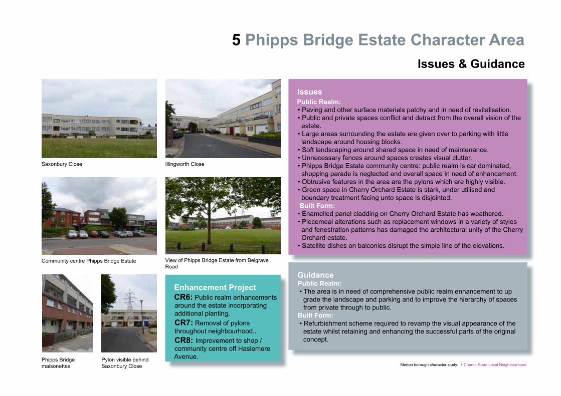
Issues Public Realm: • Paving and other surface materials patchy and in need of revitalisation. • Public and private spaces conflict and detract from the overall vision of the estate. • Large areas surrounding the estate are given over to parking with little landscape around housing blocks. • Soft landscaping around shared space in need of maintenance. • Unnecessary fences around spaces creates visual clutter. • Phipps Bridge Estate community centre: public realm is car dominated, shopping parade is neglected and overall space in need of enhancement. • Obtrusive features in the area are the pylons which are highly visible. • Green space in Cherry Orchard Estate is stark, under utilised and boundary treatment facing unto space is disjointed. Built Form: • Enamelled panel cladding on Cherry Orchard Estate has weathered. • Piecemeal alterations such as replacement windows in a variety of styles and fenestration patterns has damaged the architectural unity of the Cherry Orchard estate. • Satellite dishes on balconies disrupt the simple line of the elevations.
Guidance Public Realm: • The area is in need of comprehensive public realm enhancement to up grade the landscape and parking and to improve the hierarchy of spaces from private through to public. Built Form: • Refurbishment scheme required to revamp the visual appearance of the estate whilst retaining and enhancing the successful parts of the original concept.
Saxonbury Close Illingworth Close
Community centre Phipps Bridge Estate View of Phipps Bridge Estate from Belgrave Road
Phipps Bridge maisonettes
Pylon visible behind Saxonbury Close
Enhancement Project CR6: Public realm enhancements around the estate incorporating additional planting. CR7: Removal of pylons throughout neighbourhood.. CR8: Improvement to shop / community centre off Haslemere Avenue.
Merton borough character study: 7 Church Road Local Neighbourhood
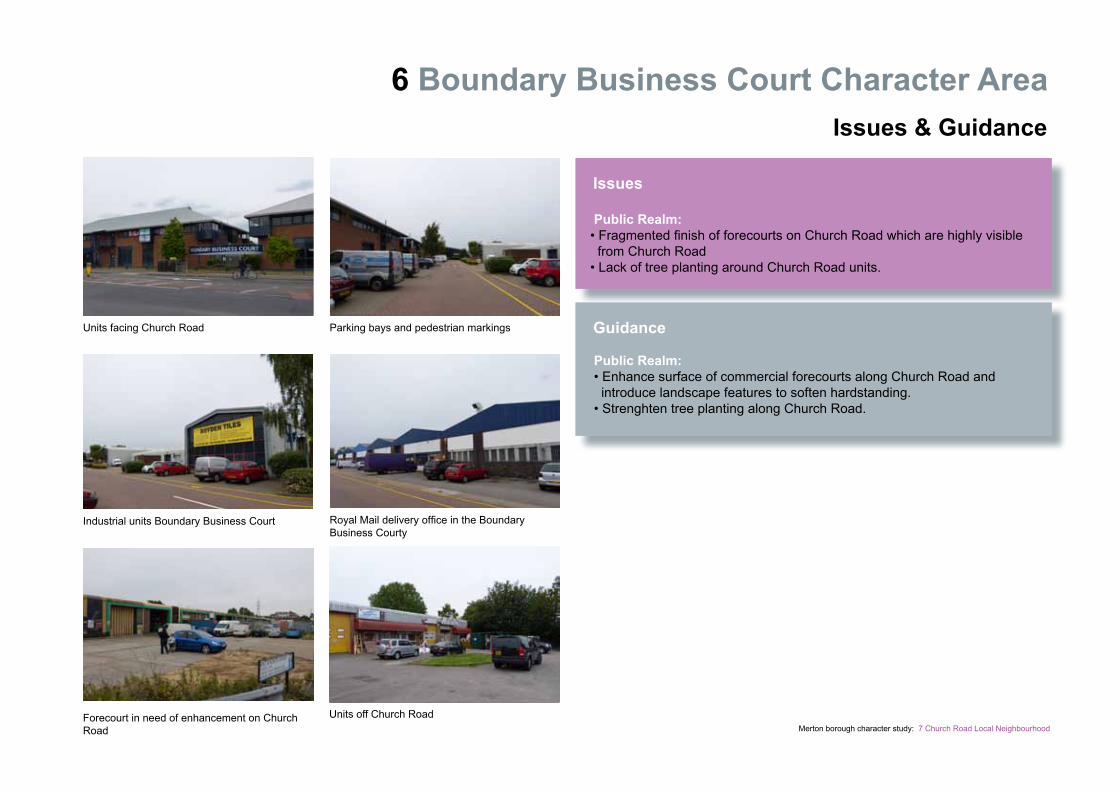
6 Boundary Business Court Character AreaAssessment
Criteria Based Assessment The qualitative attributes of each character area are assessed by using the following criteria: Identity Urban Layout Movement Architectural Interest Built Form Public Realm Trees Landscape Features Economic Vitality Each criteria point is scored according to whether the contribution made to the character area is good, moderate or poor. The total score defines whether an area is an: 1) Area of established high quality 2) Area with scope to reinforce the existing character 3) Area requiring enhancement to reinforce identity Character area assessment sheets with breakdown of score and neighbourhood assessment map are located at the end of the chapter.
Overall Score: 60 Area type: Area with scope to reinforce the existing character
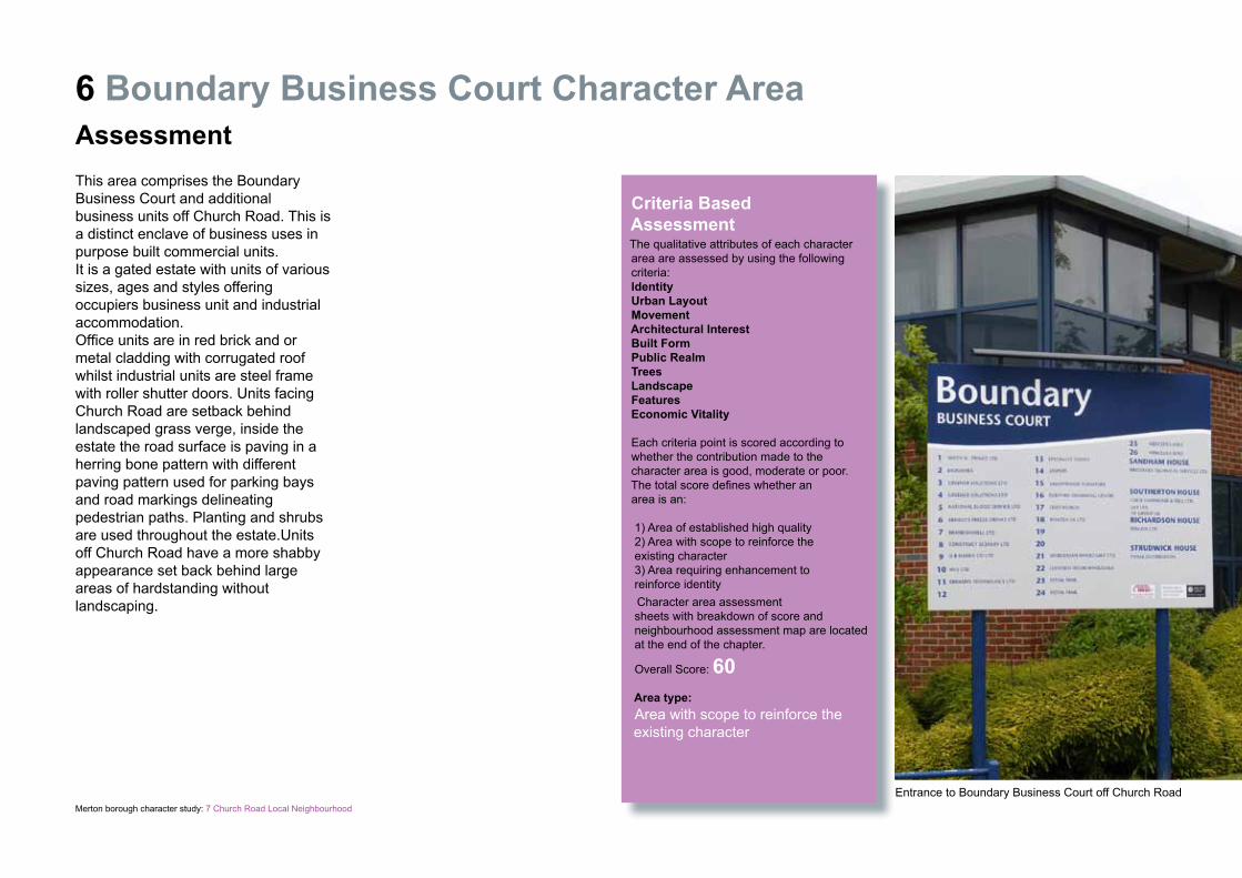
This area comprises the Boundary Business Court and additional business units off Church Road. This is a distinct enclave of business uses in purpose built commercial units.It is a gated estate with units of various sizes, ages and styles offering occupiers business unit and industrial accommodation. Office units are in red brick and or metal cladding with corrugated roof whilst industrial units are steel frame with roller shutter doors. Units facing Church Road are setback behind landscaped grass verge, inside the estate the road surface is paving in a herring bone pattern with different paving pattern used for parking bays and road markings delineating pedestrian paths. Planting and shrubs are used throughout the estate.Units off Church Road have a more shabby appearance set back behind large areas of hardstanding withoutlandscaping.
Entrance to Boundary Business Court off Church Road
Merton borough character study: 7 Church Road Local Neighbourhood
6 Boundary Business Court Character Area Issues & Guidance
Issues Public Realm: • Fragmented finish of forecourts on Church Road which are highly visible from Church Road • Lack of tree planting around Church Road units.
Guidance Public Realm: • Enhance surface of commercial forecourts along Church Road and introduce landscape features to soften hardstanding. • Strenghten tree planting along Church Road.
Units facing Church Road Parking bays and pedestrian markings
Industrial units Boundary Business Court Royal Mail delivery office in the Boundary Business Courty
Forecourt in need of enhancement on Church Road
Units off Church Road

22
Church Road Local Neighbourhood
Merton borough character study: 7 Church Road Local Neighbourhood
1 Brangwyn Crescent / Batsworth Road Character Area
Character Area Assessment Criteria Good:Makes a significant Contribution
(Value of 10)
Moderate:Makes some direct contribution
(Value of 5)
Poor:Does not contribute
(Value of 0)
Identity: Clearly identifiable edges that distinguish the area from the surrounding development
Urban Layout: Strong street pattern or road layout with well defined public spaces
Movement: Building and street layout that is easy to find your way around with good connections to the surrounding streets
Architectural Interest: Area containing buildings of architectural or historic interest
Built form: Buildings with cohesive scale, massing and details
Public Realm: High quality public realm and or generally consistent boundary treatments
Trees: Significant trees or shrubs that make a positive contribution to the identity of the area
Landscape: Green open spaces or riverside areas that make a positive contribution to the identity of the area
Features: Topography, significant views or landmarks that contribute to the experience of being within the area
Economic Vitality: Area with few vacant or underused sites which affect the character
Criteria Score 50 10
Character Area Total Score
1540
55
2 Church Road Character Area
Character Area Assessment Criteria Good:Makes a significant Contribution
(Value of 10)
Moderate:Makes some direct contribution
(Value of 5)
Poor:Does not contribute
(Value of 0)
Identity: Clearly identifiable edges that distinguish the area from the surrounding development
Urban Layout: Strong street pattern or road layout with well defined public spaces
Movement: Building and street layout that is easy to find your way around with good connections to the surrounding streets
Architectural Interest: Area containing buildings of architectural or historic interest
Built form: Buildings with cohesive scale, massing and details
Public Realm: High quality public realm and or generally consistent boundary treatments
Trees: Significant trees or shrubs that make a positive contribution to the identity of the area
Landscape: Green open spaces or riverside areas that make a positive contribution to the identity of the area
Features: Topography, significant views or landmarks that contribute to the experience of being within the area
Economic Vitality: Area with few vacant or underused sites which affect the character
Criteria Score 50 10
Character Area Total Score
2530
55

23
Church Road Local Neighbourhood
Merton borough character study: 7 Church Road Local Neighbourhood
3 Everetts Place Character Area
Character Area Assessment Criteria Good:Makes a significant Contribution
(Value of 10)
Moderate:Makes some direct contribution
(Value of 5)
Poor:Does not contribute
(Value of 0)
Identity: Clearly identifiable edges that distinguish the area from the surrounding development
Urban Layout: Strong street pattern or road layout with well defined public spaces
Movement: Building and street layout that is easy to find your way around with good connections to the surrounding streets
Architectural Interest: Area containing buildings of architectural or historic interest
Built form: Buildings with cohesive scale, massing and details
Public Realm: High quality public realm and or generally consistent boundary treatments
Trees: Significant trees or shrubs that make a positive contribution to the identity of the area
Landscape: Green open spaces or riverside areas that make a positive contribution to the identity of the area
Features: Topography, significant views or landmarks that contribute to the experience of being within the area
Economic Vitality: Area with few vacant or underused sites which affect the character
Criteria Score 50 10
Character Area Total Score
1080
90
4 Former Bunce’s Meadow Character Area
Character Area Assessment Criteria Good:Makes a significant Contribution
(Value of 10)
Moderate:Makes some direct contribution
(Value of 5)
Poor:Does not contribute
(Value of 0)
Identity: Clearly identifiable edges that distinguish the area from the surrounding development
Urban Layout: Strong street pattern or road layout with well defined public spaces
Movement: Building and street layout that is easy to find your way around with good connections to the surrounding streets
Architectural Interest: Area containing buildings of architectural or historic interest
Built form: Buildings with cohesive scale, massing and details
Public Realm: High quality public realm and or generally consistent boundary treatments
Trees: Significant trees or shrubs that make a positive contribution to the identity of the area
Landscape: Green open spaces or riverside areas that make a positive contribution to the identity of the area
Features: Topography, significant views or landmarks that contribute to the experience of being within the area
Economic Vitality: Area with few vacant or underused sites which affect the character
Criteria Score 50 10
Character Area Total Score
1060
70
24
Merton borough character study: 7 Church Road Local Neighbourhood
Church Road Local Neighbourhood5 Phipps Bridge Estate Character Area
Character Area Assessment Criteria Good:Makes a significant Contribution
(Value of 10)
Moderate:Makes some direct contribution
(Value of 5)
Poor:Does not contribute
(Value of 0)
Identity: Clearly identifiable edges that distinguish the area from the surrounding development
Urban Layout: Strong street pattern or road layout with well defined public spaces
Movement: Building and street layout that is easy to find your way around with good connections to the surrounding streets
Architectural Interest: Area containing buildings of architectural or historic interest
Built form: Buildings with cohesive scale, massing and details
Public Realm: High quality public realm and or generally consistent boundary treatments
Trees: Significant trees or shrubs that make a positive contribution to the identity of the area
Landscape: Green open spaces or riverside areas that make a positive contribution to the identity of the area
Features: Topography, significant views or landmarks that contribute to the experience of being within the area
Economic Vitality: Area with few vacant or underused sites which affect the character
Criteria Score 50 10
Character Area Total Score
2530
55
6 Boundary Business Court Character Area
Character Area Assessment Criteria Good:Makes a significant Contribution
(Value of 10)
Moderate:Makes some direct contribution
(Value of 5)
Poor:Does not contribute
(Value of 0)
Identity: Clearly identifiable edges that distinguish the area from the surrounding development
Urban Layout: Strong street pattern or road layout with well defined public spaces
Movement: Building and street layout that is easy to find your way around with good connections to the surrounding streets
Architectural Interest: Area containing buildings of architectural or historic interest
Built form: Buildings with cohesive scale, massing and details
Public Realm: High quality public realm and or generally consistent boundary treatments
Trees: Significant trees or shrubs that make a positive contribution to the identity of the area
Landscape: Green open spaces or riverside areas that make a positive contribution to the identity of the area
Features: Topography, significant views or landmarks that contribute to the experience of being within the area
Economic Vitality: Area with few vacant or underused sites which affect the character
Criteria Score 50 10
Character Area Total Score
1050
60
25
Merton borough character study: 7 Church Road Local Neighbourhood
Church Road Local NeighbourhoodCharacter Area Assessment
1
1
2
3
4
56
Area of established high quality
Area requiring enhancement to reinforce identity
Area with scope to reinforce existing character
1 Brangwyn Crescent / Batsworth Road
2 Church Road
3 Everetts Place
4 Former Bunce’s Meadow
5 Phipps Bridge Estate
6 Boundary Business Court


![W v }vE]PZ No_ 8(5).pdfLinda Halse (Mitcham Council), Melissa Jensen (Mitcham Council) and Karishma Dutta (Mitcham Council). Jill Olifent | Student Counsellor and VET Co-ordinator.](https://static.fdocuments.in/doc/165x107/5ed1477ba225a048a515d207/w-v-vepz-no-85pdf-linda-halse-mitcham-council-melissa-jensen-mitcham-council.jpg)