Micro-Pulse Lidar Network (MPLNET): 10 Years of...
17
Micro-Pulse Lidar Network (MPLNET): 10 Years of Trying to Imitate AERONET Principal Investigator: Judd Welton, NASA GSFC Code 613.1 Instrumentation & Network Management: Sebastian Stewart, SSAI GSFC Code 613.1 Data Processing & Analysis: Larry Belcher, UMBC GSFC Code 613.1 Tim Berkoff, UMBC GSFC Code 613.1 James Campbell, UCAR/Naval Research Lab Administrative Support: Sonia Cyrus, SSAI GSFC Code 613.1 GLAS Validation Activities: Jim Spinhirne, formerly NASA GSFC Code 613.1 Judd Welton, Tim Berkoff CALIPSO Validation Activities: Judd Welton, Tim Berkoff, James Campbell AERONET & Synergy Tool Partnership: Brent Holben, NASA GSFC Code 614.4 Dave Giles, NASA GSFC Code 614.4 NASA SMART-COMMIT Field Deployments: Si-Chee Tsay, NASA GSFC Code 613.2 Jack Ji, UMCP GSFC Code 613.2 Site Operations & Science Investigations …. many network partners around the world MPLNET is funded by the NASA Radiation Sciences Program and the Earth Observing System MPLNET information and results shown here are the result of efforts by all of our network partners!
Transcript of Micro-Pulse Lidar Network (MPLNET): 10 Years of...

Micro-Pulse Lidar Network (MPLNET): 10 Years of Trying to Imitate AERONET
Principal Investigator:Judd Welton, NASA GSFC Code 613.1
Instrumentation & Network Management:Sebastian Stewart, SSAI GSFC Code 613.1
Data Processing & Analysis:Larry Belcher, UMBC GSFC Code 613.1Tim Berkoff, UMBC GSFC Code 613.1
James Campbell, UCAR/Naval Research Lab
Administrative Support:Sonia Cyrus, SSAI GSFC Code 613.1
GLAS Validation Activities:Jim Spinhirne, formerly NASA GSFC Code 613.1
Judd Welton, Tim Berkoff
CALIPSO Validation Activities:Judd Welton, Tim Berkoff, James Campbell
AERONET & Synergy Tool Partnership:Brent Holben, NASA GSFC Code 614.4Dave Giles, NASA GSFC Code 614.4
NASA SMART-COMMIT Field Deployments:Si-Chee Tsay, NASA GSFC Code 613.2
Jack Ji, UMCP GSFC Code 613.2
Site Operations & Science Investigations…. many network partners around the world
MPLNET is funded by the NASA Radiation SciencesProgram and the Earth Observing System
MPLNET information and results shown here are theresult of efforts by all of our network partners!

Micro-Pulse Lidar Network (MPLNET)
http://mplnet.gsfc.nasa.gov
TropopauseCirrus
Transported Aerosol(Asian Dust, Pollution)
Boundary Layer(local aerosol)
Example of MPLNET Level 1 Data: Atmospheric StructureA
ltitu
de (k
m)
Time UTC
MPLNET Sites: 2000 - currentSouth Pole MPLNET Site:1999-current
MPLNET:
• A federated network of micro pulse lidar sites around the world, coordinated and lead from Goddard Space Flight Center
• Co-location with related networks, including NASA AERONET• Local, regional, and global scale contributions to atmospheric
research• Satellite validation• Aerosol climate and air quality model validation• Impact of aerosol & cloud heights on direct and indirect climate
effects• Support for wide variety of field campaigns
What’s New?
• Version 2 products released 2008
• Continue active publication record (+40 papers since 2000)
• Barbados site activated in 2008
• IIT Kanpur and Singapore sites activated in 2009
• Dongsha Island temporary site Feb – March 2010, one or two more temporary sites in SE Asia in support of 7-SEAS campaign
• Other planned sites in 2010: Qatar, Spain, Miami, NYC
Micro Pulse Lidar(GSFC Patent)
The Micro Pulse Lidar Network (MPLNET): Overview
18 Active Sites
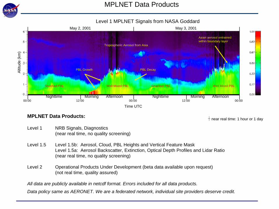
May 2, 2001 May 3, 2001
00:00 12:00 00:00 12:00 00:00Morning AfternoonNighttime Nighttime Morning Afternoon
Time UTC
Altit
ude
(km
)
Tropospheric Aerosol from Asia
Well Mixed PBL Well Mixed PBLStratified PBL Stratified PBL
Asian aerosol entrainedwithin boundary layer
PBL Growth PBL Decay
Level 1 MPLNET Signals from NASA Goddard
Micro-Pulse Lidar Network (MPLNET)MPLNET Data Products
MPLNET Data Products:
Level 1 NRB Signals, Diagnostics(near real time, no quality screening)
Level 1.5 Level 1.5b: Aerosol, Cloud, PBL Heights and Vertical Feature MaskLevel 1.5a: Aerosol Backscatter, Extinction, Optical Depth Profiles and Lidar Ratio(near real time, no quality screening)
Level 2 Operational Products Under Development (beta data available upon request)(not real time, quality assured)
All data are publicly available in netcdf format. Errors included for all data products.
Data policy same as AERONET. We are a federated network, individual site providers deserve credit.
�
near real time: 1 hour or 1 day

Micro-Pulse Lidar Network (MPLNET)Lidar Basics: Level 0 and Level 1 Data
PNRB(r) = C βM (r) + βP (r)( )e−2 σ M ( ′ r )d ′ r 0z∫ e−2 σ P ( ′ r )d ′ r 0
z∫
PRAW(r) =O(r)E
Dr2 Cβ(r)e−2 σ ( ′ r )d ′ r 0z∫⎧
⎨ ⎩
⎫ ⎬ ⎭
+Ns+ Nd
D
Level 0, Raw Lidar Signal (counts/time):
Level 1 Signal:
PMPL(r) =O(r)E
Dr2 Cβ(r)e−2 σ ( ′ r )d ′ r 0z∫⎧
⎨ ⎩
⎫ ⎬ ⎭
+A(r)
D+
Ns+ Nd
D
Overlap often insignificant for airborne and satellite lidar, not for ground-based lidar (especially the MPL)
PABS(r) = βM (r) + βP (r)( )e−2 σ M ( ′ r )d ′ r 0z∫ e−2 σ P ( ′ r )d ′ r 0
z∫
Level 1 data often reported as calibrated Attenuated Backscatter (km sr)-1 for airborne and satellite lidar
It is typically more challenging to calibrate (C) ground-based lidar because initial signal data are not acquired in the upper free trop(MPLNET level 1 data are NRB)
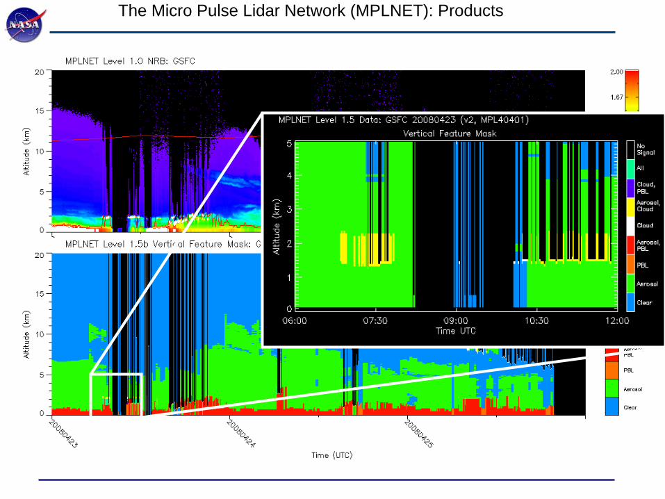
The Micro Pulse Lidar Network (MPLNET): Products
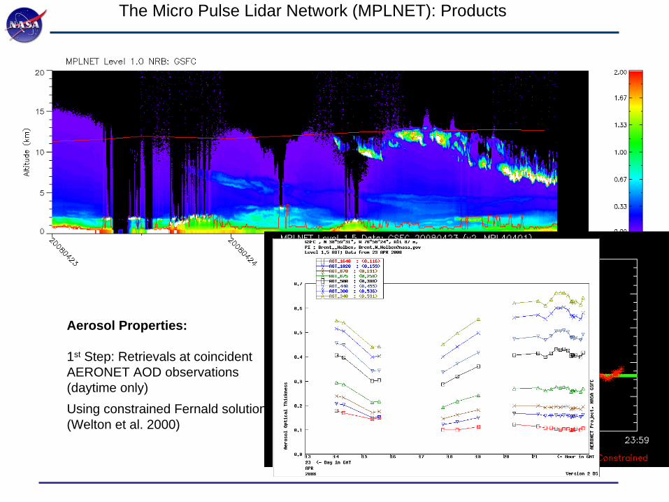
Aerosol Properties:
1st Step: Retrievals at coincident AERONET AOD observations (daytime only)Using constrained Fernald solution(Welton et al. 2000)
The Micro Pulse Lidar Network (MPLNET): Products

The Micro Pulse Lidar Network (MPLNET): Products

The Micro Pulse Lidar Network (MPLNET): Products

Validation of MPLNET Aerosol Products
How well do state-of-the-art techniques measuring the vertical profile of tropospheric aerosol extinction compare?B. Schmid, R. Ferrare, C. Flynn, R. Elleman, D. Covert, A. Strawa, E. Welton, D. Turner, H. Jonsson, J. Redemann, J. Eilers, K. Ricci, A. G. Hallar, M. Clayton, J. Michalsky, A. Smirnov, B. Holben, and J. Barnard, J. Geophys. Res., 111, D05S07, doi:10.1029/2005JD005837, 2006.
Aerosol Extinction & Optical Depth profiles compared in comprehensive study:• MPLNET (column AOT anchored to AERONET)• MPL from ARM• Airborne Ames Sunphotometer (AATS) • Airborne in-situ (nephelometer & absorption photometer)• Airborne cavity ring-down system (Cadenza)• Ground-based Raman lidar (CARL)
AATS used as truth• AATS is most direct measure of AOT profile• AATS Column AOT within 2% of AERONET
AOT
Alti
tude
(km
)
Extinction 1/km
Alti
tude
(km
)
MPLNETMPL ARMNeph/PSAPAATS
Example Comparisons from study (25 Days total).Also surveyed past 7 field campaigns of such work.
Instrument (visible wavelengths, ~520 nm) Bias Error relative to AATS Cadenza - 13% Neph / PSAP - 15% MPLNET + 13% MPL ARM + 24% CARL (Raman) + 54% Neph / PSAP Mean from 7 Campaigns - 17% Size Dist. Derived Mean from 3 Campaigns - 18% MPLNET Mean from 5 Campaigns < + 20% (work in progress)
Summary of Study Results: MPLNET among best performers
Conclusion: state-of-the-art techniques remain 15 - 20% uncertainMPLNET meets or exceeds that target range
AATS-14 shown above
The Micro Pulse Lidar Network (MPLNET): Validation

Micro-Pulse Lidar Network (MPLNET)
Existing MPLNET site
Planned MPLNET site (EZ-Lidar)
Planned Temporary MPLNET Site
SALiNAS Network (possible partner)
EPA-NCU
CRISP/NUS
Indramayu, Java
IIT Kanpur
MPLNET: Future Plans 2010-2012 (AMY, 7-SEAS, and PAC E)3
Dongsha
Kuching
Palawan
Manila
Hanoi
Pimai
SALiNAS: South Asian Lidar Network for Atmospheric Studies
Hong Kong

MPLNET: Website, Browse Tools, and Data Downloads

MPLNET: Website, Browse Tools, and Data Downloads
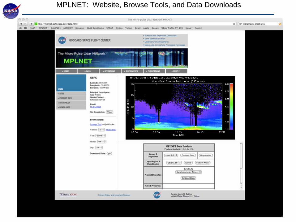
MPLNET: Website, Browse Tools, and Data Downloads

MPLNET: File Formats and Standardization
• All files in netcdf• Daily archive per site• Level 1 data rate: 1 minute, 75 meter vertical, 0 – 30 km• Standard range grid for all data (Level 1 thru Level 2), site altitude provided to construct altitude array• Level 1.5 temporal averaging required for layer heights and retrievals
• clouds: 1 min, PBL: 5 min, aerosols: 20 min• Standard temporal array for Level 1, Level 1.5b VFM, and gridded Level 1.5a data
• all data reported at 1 min regardless of data averaging for retrieval
• Varying temporal array for Level 1.5a sunphotometer constrained retrievals• all data represent 20 min averages about sunphotometer times

MPLNET: Large Data Requests
• Upon request, stage daily archive files on ftp server
• Daily archive files not ideal for large requests• too many files, especially if request data from multiple sites• archive files contain all data products for given level (1, 1.5b, 1.5a) and various diagnostics
• New user file format in development (also netcdf)• Turning point came after NCEP request for routine access to PBL heights, and …..
Paul Ginoux (GFDL) who asked for “everything”• Yearly data file containing one data product from all active sites that year
• file updated daily or weekly (TBD)• e.g. One file containing all aerosol extinction profiles from all sites for 2009
• only pertinent ancillary data and information added to file• all products conform to standard range grid• all products provided at native resolution (e.g. aerosol products at 20 minute intervals)• List of yearly product files in development
• PBL height• aerosol top height• aerosol extinction profiles• aerosol backscatter profiles• aerosol lidar ratio• aerosol column AOD• aerosol PBL AOD

MPLNET: Conclusions
• MPLNET website: http://mplnet.gsfc.nasa.gov
• MPLNET is part of the Synergy Tool, available through AERONET (and MPLNET) website• working to support EZ-Lidar sites in MPLNET framework, and synergy tool• future -> include independent lidar sites in synergy tool (added funding required)• plan to explore merged level 3 product using GEOS-5 aerosols (validation)
• Other Lidar Networks• EARLINET, NIES, AD-NET, CISLiNET, REALM, CORALNet (regional focus), NDACC (global)• ALINE, SALINAS (new, mostly lidar enthusiasts, potential for coordinated operations)• WMO GAW effort to create a coordinated global lidar network of networks/stations
• GAW Aerosol Lidar Observation Network (GALION)
• Common ground based lidar issues for operational support• most sites are run by individuals contributing to a larger effort, coordinated at major center• network rep (ie, me for MPLNET) has difficulty offering network data to operational users unless consent provided by individual network partners
• data policy conflicts… concern is that individual contributions lost in such large efforts• avoid lidar wow factor, define exactly what products/information you need from us (give me “everything” creates burden on us, and will likely create more problems for you then are solved)• do operational users want ground lidar for validation? assimilation? both?
• JMA only presentation yesterday that used ground data for assimilation

Back Up Slides