Metropolitan Pedestrian and Bicycle Planning Handbook
68
Metropolitan Pedestrian and Bicycle Planning Handbook February 2017 DOT- VNTSC-OSTR-17-02 FHWA-HEP-17-037
Transcript of Metropolitan Pedestrian and Bicycle Planning Handbook

Metropolitan Pedestrian and Bicycle
Planning Handbook
February 2017 DOT- VNTSC-OSTR-17-02 FHWA-HEP-17-037
Notice This document is disseminated under the sponsorship of the U.S. Department of Transportation in the interest of information exchange. The U.S. Government assumes no liability for use of the information contained in this document. This report does not constitute a standard, specification, or regulation. The United States Government does not endorse products or manufacturers. Trademarks or manufacturers’ names appear herein only because they are considered essential to the objective of this document.
Quality Assurance Statement The Federal Highway Administration provides high-quality information to serve Government, industry, and the public in a manner that promotes public understanding. Standards and policies are used to ensure and maximize the quality, objectivity, utility, and integrity of its information. FHWA periodically reviews quality issues and adjusts its programs and processes to ensure continuous quality improvement.
REPORT DOCUMENTATION PAGE Form Approved
OMB No. 0704-0188
Public reporting burden for this collection of information is estimated to average 1 hour per response, including the time for reviewing instructions, searching existing data sources, gathering and maintaining the data needed, and completing and reviewing the collection of information. Send comments regarding this burden estimate or any other aspect of this collection of information, including suggestions for reducing this burden, to Washington Headquarters Services, Directorate for Information Operations and Reports, 1215 Jefferson Davis Highway, Suite 1204, Arlington, VA 22202-4302, and to the Office of Management and Budget, Paperwork Reduction Project (0704-0188), Washington, DC 20503.
1. AGENCY USE ONLY (Leave blank)
2. REPORT DATE February 2017
3. REPORT TYPE AND DATES COVERED Final Report
4. TITLE AND SUBTITLE
Metropolitan Pedestrian and Bicycle Planning Handbook
5a. FUNDING NUMBERS HW2LA4/QMG29
6. AUTHOR(S) Anna Biton, James Andrew, and Jessica Baas
5b. CONTRACT NUMBER
7. PERFORMING ORGANIZATION NAME(S) AND ADDRESS(ES) U.S. Department of Transportation John A. Volpe National Transportation Systems Center Transportation Planning Division 55 Broadway Cambridge, MA 02142-1093
8. PERFORMING ORGANIZATION REPORT NUMBER
DOT-VNTSC-OSTR-17-02
9. SPONSORING/MONITORING AGENCY NAME(S) AND ADDRESS(ES) U.S. Department of Transportation Federal Highway Administration Office of Planning 1200 New Jersey Ave SE Washington, DC 20590
10. SPONSORING/MONITORING AGENCY REPORT NUMBER
FHWA-HEP-17-037
11. SUPPLEMENTARY NOTES
Federal Highway Administration: Jody McCullough, Michelle Noch, Jeremy Raw, Jim Thorne, and Jill Stark
12a. DISTRIBUTION/AVAILABILITY STATEMENT This document is available to the public on the FHWA website at: https://www.fhwa.dot.gov/planning/processes/pedestrian_bicycle/publications/mpo_handbook/
12b. DISTRIBUTION CODE
13. ABSTRACT The purpose of this handbook is to provide Metropolitan Planning Organizations (MPOs) with practical information and examples, as they consider pedestrian and bicycle transportation in their regional planning activities. Based on research including interviews with seven MPOs and critical evaluations of plans and associated documents from 11 other MPOs, this handbook covers integration of pedestrian and bicycle information into the metropolitan transportation planning process.
14. SUBJECT TERMS Nonmotorized transportation, metropolitan planning, pedestrian and bicycle planning
15. NUMBER OF PAGES 68
16. PRICE CODE
17. SECURITY CLASSIFICATION OF REPORT
Unclassified
18. SECURITY CLASSIFICATION OF THIS PAGE
Unclassified
19. SECURITY CLASSIFICATION OF ABSTRACT
Unclassified
20. LIMITATION OF ABSTRACT
Unlimited
NSN 7540-01-280-5500 Standard Form 298 (Rev. 2-89) Prescribed by ANSI
Std. 239-18 298-102
Metropolitan Pedestrian and Bicycle Planning Handbook i
Table of Contents Table of Contents ........................................................................................................................................... i
Report Notes and Acknowledgements .......................................................................................................... ii
Executive Summary .............................................................................................................................. 1
Introduction .......................................................................................................................................... 3
2.1 Handbook Organization……………………………………………………………………………………………………………4
2.2 Recommended Approaches for Getting Started or Advancing………………………………………………….5
Engaging the Public and Stakeholders .................................................................................................. 8
Analyzing Walking and Bicycling Conditions and Needs .................................................................... 11
4.1 Collect information on travel patterns, safety, and facilities…………………………………………………..11
4.2 Identify regional priorities to include in the MTP and TIP……………………………………………………….21
Developing Regional Plans, Setting Priorities ..................................................................................... 29
5.1 MTPs and Regional Pedestrian and Bicycle Plans……………………………………………………………………29
Implementing Projects ....................................................................................................................... 35
6.1 Demonstrate local support…………………………………………………………………………………………………….35
6.2 Identify and leverage funding sources……………………………………………………………………………………36
6.3 Establish project selection criteria that further the regional strategy…………………………………….38
6.4 The Transportation Improvement Program……………………………………………………………………………40
6.5 Track and evaluate progress towards achieving goals and objectives…………………………………….41
Keys to Success ................................................................................................................................... 43
Appendix A: Background and Context ........................................................................................................ 47
Federal Planning Requirements and Priorities……………………………………………………………………………………47
U.S. DOT priorities……………………………………………………………………………………………………………………………..48
Appendix B: Metropolitan Plans ................................................................................................................. 52
Appendix C: Conducting Counts ................................................................................................................. 54
Appendix D: Checklist of Possible MPO Actions ......................................................................................... 55
Appendix E: Resources and Tools ............................................................................................................... 57
List of Acronyms and Abbreviations ........................................................................................................... 63
Metropolitan Pedestrian and Bicycle Planning Handbook ii
Report Notes and Acknowledgements The following Metropolitan Planning Organization staff participated in developing this guidebook and shared their time, knowledge, and experience:
• Erick Aune, Mark Tibbetts, and Keith Wilson, Santa Fe MPO (Santa Fe, New Mexico) • Dan Brugh, New River Valley MPO (New River Valley, Virginia) • Linda Culp, San Diego Association of Governments (SANDAG) (San Diego, California) • Paul DeCamp, Augusta-Richmond MPO (Augusta, Georgia) • Dan Jatres, Karen Parsons, New Orleans Regional Planning Commission (NORPC) (New Orleans,
Louisiana) • Leslie Meehan, Nashville MPO (Nashville, Tennessee) • Ben Weiss, Aaron Wilson, Missoula MPO (Missoula, Montana)
Metropolitan Pedestrian and Bicycle Planning Handbook 1
Executive Summary This handbook was created to support Metropolitan Planning Organizations (MPOs) in fulfilling Federal requirements to fully consider pedestrian and bicycle transportation in their regional planning activities.1 Based on interviews with seven MPOs and critical evaluations of plans and associated documents from 11 other MPOs, this handbook covers pedestrian and bicycle information for inclusion in metropolitan transportation plans (MTPs) and regional pedestrian and bicycle plans. Additional information in this handbook can help MPOs:
• Collect and analyze data. • Develop goals, objectives, and strategies. • Engage stakeholders and the general public. • Establish approaches for funding and implementation. • Set regional priorities.
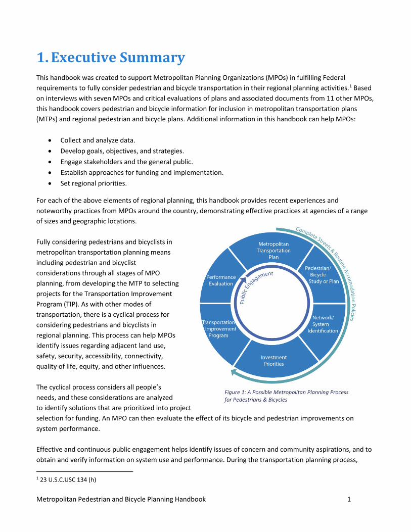
For each of the above elements of regional planning, this handbook provides recent experiences and noteworthy practices from MPOs around the country, demonstrating effective practices at agencies of a range of sizes and geographic locations. Fully considering pedestrians and bicyclists in metropolitan transportation planning means including pedestrian and bicyclist considerations through all stages of MPO planning, from developing the MTP to selecting projects for the Transportation Improvement Program (TIP). As with other modes of transportation, there is a cyclical process for considering pedestrians and bicyclists in regional planning. This process can help MPOs identify issues regarding adjacent land use, safety, security, accessibility, connectivity, quality of life, equity, and other influences. The cyclical process considers all people’s needs, and these considerations are analyzed to identify solutions that are prioritized into project selection for funding. An MPO can then evaluate the effect of its bicycle and pedestrian improvements on system performance. Effective and continuous public engagement helps identify issues of concern and community aspirations, and to obtain and verify information on system use and performance. During the transportation planning process, 1 23 U.S.C.USC 134 (h)
Figure 1: A Possible Metropolitan Planning Process for Pedestrians & Bicycles
Metropolitan Pedestrian and Bicycle Planning Handbook 2
MPOs can enact policies such as Complete Streets or routine accommodations that address pedestrians, bicyclists, and travelers of all ages, abilities, and needs into projects where nonmotorized travel is safe and feasible. The information in this document can help integrate and guide multimodal projects developed and implemented using Federal funds.
Metropolitan Pedestrian and Bicycle Planning Handbook 3
Introduction Transportation planning in metropolitan areas is a collaborative process, led by a Metropolitan Planning Organization (MPO) and other key stakeholders in the regional transportation system. MPOs consider all modes of transportation in order to serve all segments of their communities. Bicycling and walking are important elements of the transportation system that improve quality of life by providing access to jobs, education, health care, transit, and other essential services. Safe, convenient, and attractive pedestrian and bicycling environments are key components of livable communities, and good pedestrian and bicycle networks ensure that there are travel options for those who do not have access to an automobile or choose not to use one. MPO regions vary by size and geography, but all MPOs across the country must consider how to increase safety, security, and accessibility for motorized and nonmotorized users; improve quality of life; ensure consistency with local planned growth; and enhance connectivity across and between modes for pedestrian and bicycle users.2 While local governments make many decisions and investments that affect walking and bicycling, MPOs act as strong leaders in regional planning by convening and coordinating stakeholders. Walking and bicycling are part of regional mobility, and MPOs set the vision, goals, and objectives that guide the investments that support walking and bicycling mobility. The MPO examples in this handbook provide a variety of approaches to regional pedestrian and bicycle planning and represent communities diverse in size, geography, climate, and location. The smallest MPO profiled has a population of less than 100,000 people and the largest MPO profiled has a population of over 3 million people. They provide a variety of perspectives on bicycle and pedestrian planning at a regional level. The handbook examines a range of activities, including the identification and prioritization of walking and bicycling needs; data collection; performance measures; bicycle and pedestrian plans; inclusion of nonmotorized travel in the Metropolitan Transportation Plans (MTP); and programming projects in the Transportation Improvement Program (TIP). Examples provided in this document demonstrate how various planning activities enable MPOs to make effective decisions about bicycle and pedestrian projects that ensure these modes are safe, accessible, and convenient for as much of the served population as possible, through a variety of planning approaches and methods.
2 23 U.S.C.USC 134 (h) For more detailed information on legal requirements and policy priorities, see Appendix A
The term pedestrian refers to a person moving from place to place on foot or with assistance, such as with a wheelchair or guide dog.
Metropolitan Pedestrian and Bicycle Planning Handbook 4
2.1 Handbook Organization The handbook includes the following chapters:
• Engaging the Public and Stakeholders This section discusses ways that MPOs involve the public in pedestrian and bicycle planning. MPOs need to have a plan to engage stakeholders early and throughout the planning process. Engaged pedestrians and bicyclists can help provide valuable information regarding their experiences and perceptions related to walking and bicycling, and can also voice opinions on potential priority corridors or specific types of design treatments.
• Analyzing Walking and Bicycling Conditions and Needs This section suggests technical approaches MPOs can use to identify regional priorities to include in MTPs and TIPs. The discussion includes gathering data on existing travel patterns, facilities, and safety conditions. Count data, facility inventories, and crash analyses help MPOs establish regional priorities for bicycling and walking. This section includes a discussion of pedestrian and bicycling visualization, mapping, and forecasting tools.
• Developing Regional Plans and Setting Priorities This section discusses incorporating walking and bicycling in an MTP and the relationship of the MTP to other regional bicycle and pedestrian plans and studies, land use plans, and public participation. The discussion includes examples of goals and strategies from MTPs that emphasize walking and bicycling, and also how MPOs use the goals and strategies to support project prioritization. This section also describes the importance of stakeholder engagement with regard to walking and bicycle planning, both for specific plans and projects, and ongoing involvement through advisory committees.
• Influencing Funding Decisions and Tracking Progress This section discusses the processes and mechanisms MPOs can use to ensure walking and bicycling are considered in all roadway projects, such as using routine accommodation and Complete Streets policies. The section also discusses how MPOs can use eligibility standards, project selection criteria, TIPs, and annual lists of projects to effectively program projects that support walking and bicycling. Finally, this section discusses funding sources, and how to track and evaluate progress towards bicycling and walking goals for the region.
• Keys to Success This section highlights ways that MPOs go beyond minimum requirements for pedestrian and bicycle planning to build successful programs. While some of these activities are not required to comply with Federal requirements, many MPOs find these strategies and approaches useful for achieving their goals while also advancing pedestrian and bicycle transportation throughout their region. Many of these activities are scalable, meaning that MPOs can approach them with different levels of effort depending on experience and resources.
Metropolitan Pedestrian and Bicycle Planning Handbook 5
2.2 Recommended Approaches for Getting Started or Advancing Whether MPOs are getting started or advancing bicycle and pedestrian planning, their efforts will address common themes. There are also common strategies and approaches many MPOs find useful for advancing pedestrian and bicycle transportation throughout their respective regions. How a particular MPO approaches the practices described in this handbook will depend on regional needs and available resources. This section provides an overview of the themes, strategies and approaches described later.
Engage all members of the community
The fundamental objective of public participation is to ensure concerns of people with a stake in transportation decisions, and the issues they have, are identified and addressed. MPOs use public participation and stakeholder engagement to inform the planning process and engage communities in public planning and decisionmaking processes. Public involvement helps agencies make better-informed decisions and builds mutual understanding and trust between agencies and the public they serve. For pedestrian and bicycle planning, diverse engagement efforts include reaching out to representatives from advocacy groups, communities of people with disabilities, the traditionally underserved, low-income and minority populations, and others who can help provide complete perspectives on system performance and needs. Diverse representation can provide valuable information about current travel conditions, promote equity, and provide insights on the needs of the most vulnerable users of the roadway. A fundamental goal of the Americans with Disabilities Act (ADA) is to provide access to jobs and community services for people with disabilities; input from people with disabilities and their representatives helps regions make their programs and services accessible to all. Key stakeholders and partners may include municipal and community groups, transit, law enforcement, public health, and disability and accessibility commissions, and community interest and advocacy groups representing diverse, minority, and low-income communities, and business groups.
Develop regional pedestrian and bicycle planning processes
Regional pedestrian and bicycle planning processes are a useful way for MPOs to monitor conditions, track trends, and identify ways to address pedestrian and bicycle needs throughout the region. Addressing pedestrian and bicycle transportation needs in the planning process could include the following key elements:
o Building inventories of bicycle and pedestrian networks and facilities o Conducting public outreach o Selecting and evaluating performance measures o Developing goal statements or full pedestrian and bicycle transportation plans o Engaging with bicycle and pedestrian committees o Evaluating bicycle and pedestrian strategies to address plan goals
Metropolitan Pedestrian and Bicycle Planning Handbook 6
o Focusing elements of an MTP on bicycle and pedestrian transportation needs, evaluations, and recommendations
o Identifying system deficiencies o Recommending policies, programs and projects that address the role and needs of bicycle and
pedestrian transportation in a region.
MPOs may address bicycle and pedestrian transportation directly within an MTP, or by referencing a bicycle and pedestrian transportation plan developed in a separate but coordinated planning effort. Developing a regional pedestrian and bicycle plan allows an MPO to fully integrate nonmotorized needs into the MTP update process and inform TIP project selection cycles and project implementation.
Tie objectives for pedestrians and bicyclists to broader regional goals in the MTP
A multimodal transportation system provides people with reliable and affordable connections to employment, education, and other essential services, improving mobility and accessibility throughout a region. MPOs often organize MTPs around community defined visions and goals, including pedestrian and bicycle-related goals, objectives and strategies, and performance measures to focus and track progress on an MPO’s pedestrian and bicycle projects and activities. MPOs may develop project selection and funding criteria that ensure they prioritize and fund projects that reflect regional multimodal priorities and analysis of facilities. Many MPOs have also found ways to leverage other public and private funding for projects to support walking and bicycling.
Make field observations of pedestrian and bicycle activity
Many agencies make field observations of pedestrian and bicycle activity to determine current conditions and needs. Considering pedestrian and bicycle conditions requires data that may be obtained from a variety of sources. Highway Performance Monitoring System (HPMS) data are used for assessing highway system performance. The performance reporting process includes information on roadway facilities relevant to bicyclists and pedestrians including terrain, lane width, speed limit, bicycle lanes, pavement condition, and more. State and local ADA transition plans can inform planning, as these plans account for the role of accessibility in meeting multimodal goals, creating livable communities, and identifying investment needs by providing inventories of facilities and their ADA features. Crash data may be used to identify specific pedestrian and bicycle safety issues. Road safety audits provide unbiased examination and evaluation, and identify concerns related to the safety, access, comfort, and convenience of walking and biking. In addition to identifying problem areas, an audit can identify potential alternatives or solutions—such as engineering treatments, policy changes, or education and enforcement measures. Audits involve a review of all data for a location or travel corridor. A multidisciplinary team will analyze data and provide a fresh look at traffic conditions at a location or along a corridor.3 FHWA offers guidance on conducting these audits through its Office of Safety website. 3 Pedestrian and Bicycle Information Center http://www.pedbikeinfo.org/planning/tools_audits.cfm
Metropolitan Pedestrian and Bicycle Planning Handbook 7
MPOs may conduct counts of pedestrian and bicycle activity in the following ways:
1. Manual counts at key locations. 2. Additional staff and volunteers to provide support in more locations or at more frequent intervals. 3. Automated counting using either moveable or permanently installed equipment.
Whether using local jurisdiction data, advocacy group information, collecting data themselves, or supporting local governments or other agencies with data collection, MPOs increasingly use pedestrian and bicycle count data cooperatively to estimate need, prioritize projects, evaluate successes, and quantify impacts. In developing this handbook, the project team reviewed documents from several MPOs and engaged in structured discussions with staff from the following MPOs:
• Augusta-Richmond MPO (Augusta, Georgia) • Missoula MPO (Missoula, Montana) • Nashville MPO (Nashville, Tennessee) • New Orleans Regional Planning Commission (NORPC) (New Orleans, Louisiana) • New River Valley (NRV) MPO (New River Valley, Virginia) • San Diego Association of Governments (SANDAG) (San Diego, California) • Santa Fe MPO (Santa Fe, New Mexico)
“Conducting a regional bicycle plan for Western North Carolina is not as easy as simply identifying solutions for mountain communities; it’s
about identifying and articulating the best fit solutions to improve safety and increase the potential for people to bicycle around the
region. The manner in which bicyclists are accommodated on routes throughout the area also impacts the region’s attraction as a place for tourists who may want to bike as part or all of their vacation.”
–Land of Sky MPO, Blue Ridge Bike Plan

Metropolitan Pedestrian and Bicycle Planning Handbook 8
Engaging the Public and Stakeholders While public participation is essential to all aspects of transportation and land use planning, it is crucial in pedestrian and bicycle planning. Engaging the public is important because populations that are typically underserved by the transportation system—younger, older, lower income, low-English proficiency, disabled, and minority communities—may rely on walking, bicycling, and transit more than the population as a whole. Public involvement is also critical to good pedestrian and bicycle planning because these modes often lack the robust data available for automobiles and public transit. Engaged pedestrians and bicyclists can provide valuable information about their experiences, and can voice opinions on potential priority corridors or specific types of design treatments. Representatives of people with disabilities can provide insights on accessibility needs, including eliminating structural barriers, to ensure that pedestrian and bicycle improvements are accessible to all people. Supporting successful connections between transit and pedestrian and bicycle facilities requires cooperation and commitment from all relevant transportation agencies, from State to regional to local levels. Collaboration, rather than working alone, is key to building successful projects and networks. The FHWA Public Involvement/Public Participation webpage provides extensive information for involving the public in transportation planning, as well as resources to help agencies develop and tailor their public participation programs.
Include stakeholders to maximize results Engaging stakeholders can help MPOs identify problems and areas to address. User experiences can fill gaps or expand on existing data related to walking and bicycling. Bicyclists and pedestrians can identify areas or crossings where they have observed unsafe infrastructure or behavior, even if those areas do not have high crash statistics. Effective stakeholder engagement can also help build public support for plan implementation. MPOs often find it invaluable to work with advocacy groups because they can provide additional resources or information and staff support. Effective stakeholder engagement can also help build public support for plan
PlanWorks is a tool that supports collaborative decisionmaking in transportation planning and project development. The FHWA tool is built around key decision points in long-range planning, programming, corridor planning, and environmental review. PlanWorks suggests when and how to engage partners and stakeholders at the right time. It includes a bicycle-pedestrian application to help transportation agencies and other partners fully integrate pedestrian and bicycle planning and design into the formal planning process.
Metropolitan Pedestrian and Bicycle Planning Handbook 9
implementation. For walking and bicycling activities at the MPO level, stakeholders may include members from advocacy or special interest groups, local government staff, transit agencies, representatives of persons with disabilities, representatives of educational institutions, and public health professionals.
Use various methods to engage stakeholders The variety of planning activities that MPOs perform require different processes and methods for stakeholder engagement. There may be specific outreach efforts related to discrete plan or study activities, in addition to ongoing advisory committees. Public involvement methods can range from in-person workshops and meetings to virtual comment forms and interactive websites. The appropriate mix of approaches depends on timing, resources, and intended audience. MPOs can use surveys to gather information about current behavior and unmet or latent demand. In addition to telephone surveys, MPOs can use Internet-based or mail-in surveys. MPOs can conduct surveys specific to walking and bicycling, or incorporate specific questions related to walking and bicycling into a broader regional household travel survey. As part of its 2035 Regional Plan, the Nashville MPO conducted a random sample 10-county survey asking residents how they would like to spend transportation dollars. Based on more than 1,100 responses, the survey results indicated that residents first preferred to prioritize mass transit, make communities more walkable and bikeable next, and lastly build new roads. The survey results helped guide funding decisions and demonstrated public support for investments in walking and bicycling. There are many examples of innovations in crowdsourced mapping applications that allow bicyclists to log trips and comment on road conditions. The San Francisco County Transportation Authority developed a Geographic Information System (GIS)-based smart phone app called CycleTracks, and have authorized other MPOs, such as the Metropolitan Council and Puget Sound Regional Council, to use it. The MPOs use the app to learn more about routes that cyclists take in their regions and to verify assumptions about their bicycling networks. Similar bicyclist route data is available from commercial sources as well, and application developers are continuously finding new ways for the public to contribute information about the condition of the transportation system.
Use technical and advisory committees throughout the planning and programming process Many MPOs involve stakeholders through advisory committees that meet regularly throughout the process of developing a plan or participate in reviewing projects for Federal funding. Citizen and technical advisory committees can help to review federally funded projects and provide input on plan and policy developments. The Metropolitan Transportation Commission (MTC) in the San Francisco Bay Area requires that individual county advisory committees review each project submitted for funding to ensure that they accommodate walking and bicycling needs. These advisory committees are also involved in plan development and assessment, and include members representing incorporated and unincorporated parts of the county so that different types of pedestrian and bicycle needs are adequately understood.
Metropolitan Pedestrian and Bicycle Planning Handbook 10
Coordinate with State DOTs Since MPO planning shares many responsibilities with statewide planning conducted by State Transportation Agencies, it is important for MPOs to coordinate and not conflict with statewide plans and policies. While MPOs lead the metropolitan planning process, involving staff and officials from State DOTs allows for early discussion of inconsistencies in priorities and aligns MPO bicycle and pedestrian planning with State efforts. For example, the Blue Ridge Bike Plan in North Carolina centers on five themes that align with State goals.4 These themes are derived from public surveys, community workshops, and steering committee meetings. They also correlate with WalkBikeNC pillars of mobility, economic development, environment, health, and safety.
4Blue Ridge Bike Plan, page 4. http://www.landofsky.org/pdf/LGS/BRBP/BlueRidgeBikePlan_2014_web.pdf
Metropolitan Pedestrian and Bicycle Planning Handbook 11
Analyzing Walking and Bicycling Conditions and Needs
Federal transportation law requires that MPOs give due consideration to the needs of bicyclists and pedestrians in statewide and metropolitan transportation planning. While methods and analyses differ, fully considering walking and bicycling in transportation planning simply means considering walking and bicycling in a similar fashion to any other mode of travel. By accounting for existing conditions and desired future conditions envisioned in the long range planning process, and also taking into account the needs of users of all ages, abilities, income, and race, MPOs can:
• Analyze how well existing facilities meet safety, convenience, comfort, and other needs. • Analyze where people need and want to go such as jobs, essential services, shopping, schools, and parks
and recreation areas. • Develop strategies to improve conditions. • Identify trips for which people currently or would want to travel by foot or by bicycle, such as first and
last mile connections to transit.
This chapter identifies approaches that some leading MPOs have taken to address and understand the current state of walking and bicycling in their regions. These examples can provide ideas and support for MPOs that want to improve planning for pedestrians and bicyclists—but they do not imply a prescription for any MPO. Each MPO should select strategies that reflect their needs and resources. Small MPOs may want to take a bottom-up approach and begin decisionmaking with data from their leading city, while large MPOs may need to spend considerable time coordinating with many jurisdictions in order to develop common priorities for pedestrians and bicyclists. Some MPOs may need to adopt new data collection and analysis techniques to answer questions about where people want to go and how well existing facilities serve those needs. Activities highlighted here can help MPOs make strategic decisions about projects and features during regular MPO planning and programming activities, such as developing MTPs, regional pedestrian and bicycle plans, and TIPs.
4.1 Collect information on travel patterns, safety, and facilities
Analyze existing travel behavior
MPOs often analyze existing conditions as a first step in transportation planning. These analyses establish a baseline and help to track change over time. Some MPOs have identified pedestrian and bicycle travel as requiring unique attention since pedestrians and bicyclists are often the most vulnerable road users. For example, New Orleans RPC states that, “due to decreased visibility, lack of awareness, and simple physical exposure, pedestrians and bicyclists are especially vulnerable to conflicts with automobiles, and safety is a
Metropolitan Pedestrian and Bicycle Planning Handbook 12
critical consideration when designing transportation infrastructure and educating the public.”5 MPOs and local jurisdictions benefit from having robust information on the extent and condition of walking and bicycling facilities, as well as usage patterns and rates, in order to make informed planning decisions. More advanced MPO pedestrian and bicycle planning may include data collection on:
• Connections to transit. • Inventory and condition of existing pedestrian and bicycle facilities, and currently recommended future
pedestrian and bicycle network. • Locations of crashes involving pedestrians and bicyclists, which may require partnerships with public
safety organizations or a State DOT. • Pedestrian and bicycle counts.
Data collected in these areas can lay the groundwork for designating regional pedestrian and bicycle networks, and will help local governments as they develop pedestrian and bicycle plans.
5 Page 91 http://www.norpc.org/assets/pdf-documents/2044%20NO%20MTP%20FINAL%20ADOPTED.pdf
“Like walking, bicycling is an important adjunct to public transit as a transportation option. For many transit users the bicycle is a critical
component of their access to the bus system or commuter rail. Facilities such as bike lanes, urban trails, bike parking, space for bikes
on buses and trains, and even ‘bike share’ systems (or inexpensive bicycle rentals) all contribute to solving transit’s difficulty in helping prospective users take care of the first or last mile(s) of their trips –
the part that is not covered by existing bus or train service. Along with transit and walking, developing infrastructure for bicyclists can also result in saving time and space for motorists. In that they work as motor vehicle ‘congestion mitigation,’ these modes can serve to
reduce road maintenance and construction costs, fuel consumption, and the amount of public and private space dedicated to roadways
and parking.”
-Santa Fe MPO Bicycle Plan
Metropolitan Pedestrian and Bicycle Planning Handbook 13
Identify where people want to walk and bike
People who bicycle and walk need access to the same destinations as people using any other mode. As part of the long range planning process, MPOs identify the primary locations of activity in their respective regions and evaluate accessibility in these regions by any mode, including walking and bicycling. Key activity areas may include destinations such as grocery stores, employment centers, shopping centers and districts, universities, medical facilities, hospitals, entertainment districts, and recreation areas, and first- and last-mile connections to transit. It is helpful to identify these key destinations on pedestrian and bicycle network planning maps. Assessing active transportation networks as a form of transportation rather than as recreational facilities, can create stronger, more efficient outcomes for all users. Furthermore, redefining transit to include bicycling and walking ensures these modes are viewed as transportation rather than leisure activities and can help increase funding for improvements to and expansion of bicycle and pedestrian networks. High-density residential neighborhoods, areas with low rates of car ownership, primary and secondary schools, intermodal public transit hubs including airports, train, ferry, bus, and light rail stations and stops may be a priority for improvement. For example, NORPC notes in its MTP that because New Orleans has, “high rates of people with limited access to a private vehicle and low median household incomes, the provision of safe, affordable, and convenient transportation options such as walking and bicycling is an important component of the overall transportation. Neighborhoods that are predominantly low-income are, therefore, weighted more heavily when selecting locations for new pedestrian and bicycle facilities.”6
Comprehensive plans and nonmotorized transportation
Comprehensive land use plans developed by local and regional planning agencies typically include
6 Page 92 http://www.norpc.org/assets/pdfdocuments/2044%20NO%20MTP%20FINAL%20ADOPTED.pdf
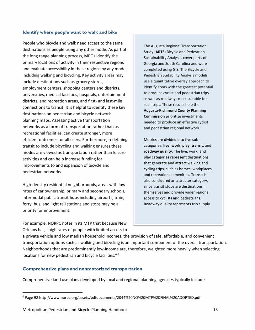
The Augusta Regional Transportation Study (ARTS) Bicycle and Pedestrian Sustainability Analyses cover parts of Georgia and South Carolina and were completed using GIS. The Bicycle and Pedestrian Suitability Analysis models use a quantitative overlay approach to identify areas with the greatest potential to produce cyclist and pedestrian trips, as well as roadways most suitable for such trips. These results help the Augusta-Richmond County Planning Commission prioritize investments needed to produce an effective cyclist and pedestrian regional network. Metrics are divided into five sub-categories: live, work, play, transit, and roadway quality. The live, work, and play categories represent destinations that generate and attract walking and cycling trips, such as homes, workplaces, and recreational amenities. Transit is also considered an attractor category, since transit stops are destinations in themselves and provide wider regional access to cyclists and pedestrians. Roadway quality represents trip supply.
Metropolitan Pedestrian and Bicycle Planning Handbook 14
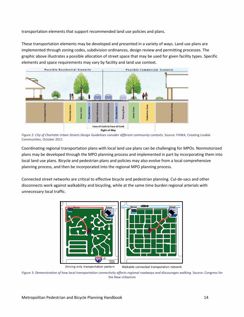
transportation elements that support recommended land use policies and plans. These transportation elements may be developed and presented in a variety of ways. Land use plans are implemented through zoning codes, subdivision ordinances, design review and permitting processes. The graphic above illustrates a possible allocation of street space that may be used for given facility types. Specific elements and space requirements may vary by facility and land use context.
Figure 2: City of Charlotte Urban Streets Design Guidelines consider different community contexts. Source: FHWA, Creating Livable Communities, October 2011
Coordinating regional transportation plans with local land use plans can be challenging for MPOs. Nonmotorized plans may be developed through the MPO planning process and implemented in part by incorporating them into local land use plans. Bicycle and pedestrian plans and policies may also evolve from a local comprehensive planning process, and then be incorporated into the regional MPO planning process. Connected street networks are critical to effective bicycle and pedestrian planning. Cul-de-sacs and other disconnects work against walkability and bicycling, while at the same time burden regional arterials with unnecessary local traffic.
Figure 3: Demonstration of how local transportation connectivity affects regional roadways and discourages walking. Source: Congress for
the New Urbanism
Metropolitan Pedestrian and Bicycle Planning Handbook 15
Create a walking and bicycling facility inventory
An inventory of existing walking and bicycling infrastructure provides a baseline for MPOs that may include sidewalks, curb ramps, pedestrian and bicycle signals, bike lanes, separated bike lanes, wide shoulders, shared-use paths, and bike parking. MPOs use a variety of methods to develop an inventory depending on the size of their region, the level of detail needed on facility type, and how they plan to use the inventory. For some MPOs it is enough to simply catalog the presence of or need for a facility, and go into more depth for specific projects. For others it may be more appropriate to include detailed information such as facility type, width, and condition. Depending on the detail needed for the inventory, MPOs may collect new information by taking pictures and recording data while driving and biking key regional corridors, or compiling existing aerial photos or GIS files. The Greater Buffalo-Niagara MPO maintains an inventory of bike lane miles, and uses a windshield survey to assess road surfaces and conditions. The information feeds into a Bicycle Level of Service calculation, which also includes width of outside travel lane and shoulder, condition of roadway, presence of parking, land use, driveways, conflict points, sewer grates, roadway traffic volumes and truck percentage, and posted speed limits. The Nashville MPO also completed a windshield survey for its 2009 Bicycle and Pedestrian Study, in which it inventoried all sidewalks in the region. For a fairly modest cost, the Nashville MPO hired a consultant who drove all 3,300 miles of roads in the MPO’s jurisdiction. Nashville MPO decided that it was simpler to do the inventory all at once, rather than encounter potential inconsistencies, and to combine GIS files from all of the local agencies in its jurisdiction. The inventory simply notes the presence or absence of sidewalks—if more detail is needed on the condition of the sidewalk in a specific place, the MPO follows up separately. The MPO uses the sidewalk inventory information in its Pedestrian Level of Service analysis, and updates the sidewalk inventory with Google Earth and the Tennessee DOT database. State DOTs also maintain roadway inventories, which are a record of State highway features and may include reliable data on walking and bicycling facilities on State highways. Similarly, many local jurisdictions complete their own sidewalk and bicycle infrastructure inventories. MPOs can build in processes for regular updates and maintenance to the inventory as part of activities such as TIP development or tracking, MTP data collection, and tracking performance measures. MPOs may use Federal metropolitan planning funds for gathering data or coordinating data collection efforts.
ADA and State and local inventories
An ADA transition plan identifies system needs and integrates these needs with the State's planning process. These plans include an inventory, strategies, and schedule for correcting gaps in pedestrian facilities. State and local governments also develop inventories of accessible pedestrian facilities as part of their ADA transition plans. These inventories guide modifications to facilities to make them accessible to individuals with disabilities—see Appendix A for more on ADA requirements. The ADA transition plan is intended to identify system needs and integrate them with the State's planning process. The transition plan and identified needs
Metropolitan Pedestrian and Bicycle Planning Handbook 16
should be fully integrated into an agency's Statewide Transportation Improvement Program and Transportation Improvement Program. Agencies should incorporate accessibility improvements into the transportation program on an ongoing basis in a variety of ways:
• Accessibility improvements identified in the transition plan that are not within the scope of an alteration project should be incorporated into the overall transportation planning process. This can be accomplished by developing stand-alone accessibility projects.
• Construction projects that are programmed must meet accessibility requirements when built. • To identify ADA compliance needs, when scheduling maintenance activities agencies should identify
ADA accessibility needs and incorporate them into the overall transportation planning process.
ADA Transition Plan inventories of facilities by local governments and State DOTs may be a reliable source of inventory data. They can be used as a basis for a full network inventory by the MPO. MPOs not only need to integrate projects that come out of Transition Plans in the Transportation Improvement Program, but should show that the region is making progress against the needs identified in the ADA Transition Plans for their member communities. For these reasons, ADA Transition Plans may be a good place to begin data collection for regional pedestrian planning. The Santa Fe MPO coordinated its pedestrian infrastructure inventory for its Pedestrian Master Plan with the ADA transition plan for the City of Santa Fe. To complete the pedestrian infrastructure inventory, the Santa Fe MPO focused on two prominent types of destinations across the planning area: educational institutions and public transit system stops. The study area buffer spanned a quarter-mile, about a 5-minute walk. The nearly 30 square mile study area includes more than half of the land within Santa Fe, and is the basis for examining existing pedestrian infrastructure where it can best serve pedestrian-oriented populations.
Collect count data
FHWA recognizes the need to support MPOs and State DOTs in advancing bicycle and pedestrian count programs so that MPOs and local governments have up-to-date information on existing and latent demand for various facility treatments. The Transportation Planning Capacity Building Program peer exchange on Bicycle and Pedestrian Count Programs brought together five agencies to learn from each other about approaches to pedestrian and bicycle data collection programs. FHWA also offers an overview of pedestrian and bicycle traffic data collection techniques as part of the Traffic Monitoring Guide. To assist MPOs in implementing count methodologies consistent with the Traffic Monitoring Guide, FHWA announced the Bicycle-Pedestrian Count Technology Pilot Project in April 2015. FHWA selected 10 MPOs without existing pedestrian and bicycle count programs to receive funding and technical assistance to develop a count program, identify and deploy counting technology, and analyze data. See the FHWA Bicycle-Pedestrian Count Technology Pilot Project summary report for details on the project, including lessons learned and key benefits. Sample policies, plans, and more are also available from the
For more information on pedestrian counting methodologies, see the webinar Pedestrians Count! from Portland State University.
Metropolitan Pedestrian and Bicycle Planning Handbook 17
Pedestrian and Bicycle Information Center.
MPO-led counting programs
The San Diego Association of Governments (SANDAG) uses automatic counters for its bicycle counting program. SANDAG has partnered closely with San Diego State University, which has the largest network of counters in the country funded in part through a Centers for Disease Control and Prevention) (CDC) grant called Communities Putting Prevention to Work. This grant funded 54 in-pavement and infrared bike counters installed at various points along the regional bicycle network. Data from the counters are uploaded every 15 minutes. The City of San Diego has also purchased 100 camera counters and the MPO will coordinate all counts to build a robust set of traffic data that can be used in the regional travel demand model. SANDAG also requires any applicant for funding to conduct before and after counts in order for a project to be eligible. The Delaware Valley Regional Planning Commission (DVRPC) began its bicycle and pedestrian data collection program in 2009. The MPO collects 3 types of bicycle and pedestrian count data to support planning decisions: Cyclical, permanent, and project specific projects. DVRPC has 12 permanent counting sites, with 6 new sites pending. The permanent counters are in a range of location—urban, rural, and suburban—and on a variety of facility types, such as trails and on-street facilities. Data from the counters is used to develop seasonal correction factors and to calculate average annual daily pedestrian and bicycle (AADP and AADB) travel, a parallel to average annual daily travel (AADT) for vehicles. In 2014, DVRPC launched its cyclical count program, in which sites are counted for a week-long period on approximately a 3-year rotation. Data from the cyclical counts are adjusted using AADP and AADB calculations based on data from the permanent counters. The counts are used to track mode share trends or activity at a specific location. For the first year of the cyclical program, 150 locations were counted. Going forward, 50 locations will be counted for each cycle. The Nashville Area MPO conducts regional bicycle and pedestrian counts as part of the National Bicycle and Pedestrian Documentation Project. In 2013, counts were conducted at 33 locations throughout the MPO region (Davidson, Rutherford, Sumner, Wilson, and Williamson Counties). The counts were organized by the MPO and staffed by volunteers. The Missoula MPO in Montana started its count program in 2010, following the National Bicycle and Pedestrian Documentation Project guidelines. The MPO conducts counts at 17 locations annually and an additional 16 locations every other year. The MPO installed their first permanent counter on a high-use trail in 2014, and now has 6 permanent counters on 2 major trails. There are plans to install more with other trail and roadway construction projects. The Missoula MPO uses count data when applying for funds, for model inputs, and to make the economic case for investing in trails and other facilities.
Summary Report: DOT Pedestrian and Bicyclist Road Safety Assessments MPOs were important partners in the effort led by US DOT. MPOs convened municipalities, State DOTs, and transit agencies. Assessment teams addressed issues related to pedestrian and bicycle safety, as well as other aspects.
Metropolitan Pedestrian and Bicycle Planning Handbook 18
Safety conditions and concerns
All MPOs have an interest and a role to play in ensuring the safety of all transportation system users. MAP-21 introduced the safety goal of achieving significant reductions in traffic fatalities and serious injuries on all public roads—this goal was reaffirmed in the FAST Act. MPOs can address safety goals, objectives, and measures in MTP and other policy documents, as well as by establishing project selection criteria that address safety. These areas are an opportunity to consider safety needs of all users, including the unique needs and concerns of pedestrians and bicyclists. The Safety Performance Management Final Rule7 supports the Highway Safety Improvement Program (HSIP) in that it establishes safety performance measures to assess serious injuries and fatalities on all public roads. The Safety PM Final Rule establishes five performance measures to carry out the HSIP using five-year rolling averages for:
1. Number of fatalities. 2. Fatality rate per 100 million vehicle miles travelled (VMT). 3. Number of serious injuries. 4. Rate of serious injuries per 100 million VMT. 5. Number of nonmotorized fatalities and serious injuries.
These safety performance measures are applicable to all public roads regardless of ownership or functional classification. The Santa Fe MPO used its road safety improvement study, with crash data from 2006 to 2011, in developing its pedestrian plan. By putting pedestrian planning within a safety framework, the Santa Fe plan connects the goals of increasing walking with reducing injuries and fatalities on its roads.
Collect and analyze crash data
Pedestrian and bicyclist safety can be a starting point for data collection, by identifying current use, facilities that will fit in environmental and land use contexts, and exposure risk to ensure the safety of all users. Crash locations can help identify safety problems throughout the transportation network. Safety data may be available at the State DOT level. MPOs may be able to use their role as convener of multiple jurisdictions to work with State DOTs and safety agencies or local jurisdictions, and can acquire data from sources such as police, emergency responders, and hospitals. Stakeholder and public engagement can also be effective in getting information on opportunities and feedback areas that have been hard to identify.
7 Part 490 to title 23 of the Code of Federal Regulations to implement the performance management requirements in 23 U.S.C. 150.
Applying Safety Data and Analysis to Performance–Based Transportation Planning The guidebook provides State and regional planners with information on how to effectively use safety data and analysis tools in performance-based transportation planning and programming. The guidebook provides examples the types of safety data to inform planning and programming decisions and ways to address these topics.
Metropolitan Pedestrian and Bicycle Planning Handbook 19
New Orleans RPC fostered a strong relationship with the State DOT to maintain up-to-date crash data. The agency began to receive crash data from the Louisiana Department of Transportation and Development (LaDOTD) in 1999. Since then, the MPO has worked with police departments to educate them about traffic laws related to bicycling and walking as well as on good practices for collecting data from traffic incidents. The MPO uses data from police reports submitted to LaDOTD. It was the first MPO in Louisiana to obtain data directly from the State and use this information in its safety analyses. In 2006, New Orleans RPC created a bicycle and pedestrian plan with an extensive bicycle and pedestrian crash analysis. The crash analysis examines many variables such as income, age, race, and characteristics of the built environment at crash locations. This analysis laid the groundwork for the agency’s emphasis on safety, and safety is the first goal area in the current MTP. The plan sets a goal of reducing bicycle and pedestrian crashes by 50 percent by 2030. The Augusta Regional Transportation Study (ARTS) Plan will result in an integrated, seamless framework to facilitate walking and biking as viable transportation choices throughout the entire region. To better understand bicyclist and pedestrian needs, the MPO conducted a detailed analysis investigating current safety, suitability, and demand for bicycling and walking in the ARTS region. This analysis is divided into four parts:
• Bicyclist and pedestrian count results and their implications. • Current bicyclist and pedestrian suitability in the region. • Demand and benefit analysis of bicycling and walking in the region. • Safety analysis including an investigation of crashes involving bicyclists and pedestrians in the region.
Conduct a safety audit or assessment
An assessment is an informal, on-the-ground examination of transportation facilities conducted by a multidisciplinary and multiagency team. MPOs may play a variety of roles regarding assessments, whether leading them or assisting local governments in performing assessments by providing data and education on using assessment tools. Many MPOs use pedestrian and bicycle safety assessments to bring together stakeholders to examine conditions for bicyclists and pedestrians at an intersection or corridor, as well as broader systemic concerns about pedestrian and bicycle safety. An assessment can focus on making recommendations for a specific roadway segment or project, or can have a broader scope by using conditions around the assessment site to help understand issues related to roadway design, policies, and interdisciplinary coordination that may lead to challenging conditions for walking and bicycling.8 To inform its pedestrian plan, the Santa Fe MPO conducted a series of walk audits and identified improvements that could transform the areas into safer walking environments, such as road diets, improving crosswalk visibility and lighting, and adding advance warning signs to mid-block crossings. 8 The FHWA Office of Safety also provides a more comprehensive Road Safety Audit (RSA) program; RSAs are more formal safety performance examinations of existing or future roads or intersections by an independent, multidisciplinary team. RSAs are an important tool, but tend to be more engineering focused rather than planning focused. For more information on RSAs see: http://safety.fhwa.dot.gov/rsa/
Metropolitan Pedestrian and Bicycle Planning Handbook 20
At the project scale, assessments are useful for identifying critical safety concerns to address in project design. At the planning scale, MPOs and local governments can use assessments to better understand safety and accessibility concerns and use the results to highlight the need for future projects or further studies to address those concerns. The results can help make a compelling case in funding applications, establish the need for improvements, and demonstrate support from multiple stakeholders. For example, the Land of Sky Regional Council’s Blue Ridge Bike Plan includes roadway safety audits to inform system performance measures.
Model and forecast travel behavior
Modeling plays is important role in regional transportation planning, particularly for larger MPOs. Travel demand models and integrated land use models help regions explore investment scenarios during planning, and analyze projected regional impacts of investment decisions. However, the scope of such models may not align well with the highly localized character of bicycle and pedestrian activities. Bicycle and pedestrian modeling is still a relatively new research area, and MPOs may benefit initially more from a focus on collecting count and inventory data, as this information can provide immediate feedback on the benefits of facility improvements after they are opened. A well-developed program of counting and facility inventory collection will also be essential to support later modeling efforts of any type. Regional models sometimes have a large margin of error when used for bicycle and pedestrian analysis for these reasons:
• Intrinsic variability of walking and biking. • The sensitivity of these modes to small-scale obstacles and
facilities. • Limited use of such modes, especially bicycling. • Wide variation in existing conditions across most regions.
Other modeling tools apart from traditional regional demand models are available, and may be of more benefit for evaluating the benefits and outcomes of nonmotorized mode improvements. Estimating Bicycling and Walking for Planning and Project Development: A Guidebook is a report from The National Cooperative Highway Research Program (NCHRP) that reviews some of these alternate approaches. For example, using access analysis (sometimes referred to as “accessibility” analysis that is distinct from analysis of accessibility for persons with disabilities) can provide an effective measure of utility. Access measures can address various types of opportunities, such as employment, retail, or health care, which are available at different locations via a given mode. Access is a particularly useful measure because it reflects the interaction of activities available given land use patterns and the ease with which users can reach those activities over the travel network.
Bicycle and pedestrian modeling is still a relatively new. MPOs starting or advancing their program can focus on collecting count and inventory data, as this information can provide immediate feedback on the benefits of the facility.
Metropolitan Pedestrian and Bicycle Planning Handbook 21
The Southeast Michigan Council of Governments (SEMCOG), the MPO for Detroit, MI, recently conducted a regional assessment of barriers residents in the Detroit metropolitan area face reaching key services using different transportation modes. Access to Core Services in Southeast Michigan found that residents of the region generally have moderate to high levels of access to all of the core services in southeastern Michigan by car, although some gaps exist. But residents face significant gaps in accessing core services by transit, walking, and bicycling. Some MPOs use GIS-based access analysis to create a simpler and more intuitive modeling process for nonmotorized modes. For example, estimating walk trip generation and mode split may rely exclusively on GIS tools and data, rather than on extensions to motorized models. This approach uses geospatial overlay and network path-building procedures readily available in GIS software to calculate measures of accessibility to or from any point by any mode and by type of attraction. By comparing modal accessibilities, an MPO can estimate mode split and create walk trip tables by purpose.9 Some MPOs use scenario planning tools that estimate the feasibility of nonmotorized travel and VMT reduction in relationship to alternative land use and transportation investment scenarios. These tools also rely on GIS to depict alternative land use and transportation configurations and estimate their effect on travel behavior, though without detailed network analysis. Such tools may be used independently for local area planning, or in tandem with an existing regional model—even one that does not intrinsically address nonmotorized travel—for larger area assessments. For more information on the current state of the practice of bicycle and pedestrian modelling and forecasting, see this 2015 white paper from the Pedestrian and Bicycle Information Center. Additional resources for bicycle and pedestrian modeling are under development.
4.2 Identify regional priorities to include in the MTP and TIP One way MPOs can bring together analyses of safety, travel demand, and existing conditions to support walking and bicycling is to develop and focus resources on a regional priority network or priority corridors and subareas within the region. Modal elements of Metropolitan Transportation Plans often identify a hierarchy of priority for various systems, like the functional classification of roads.
9 Page 35 http://onlinepubs.trb.org/onlinepubs/nchrp/nchrp_rpt_770.pdf
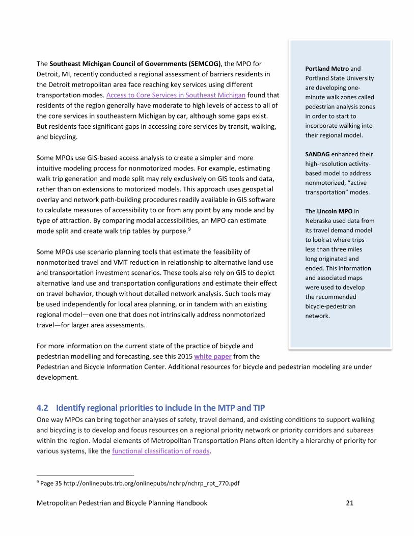
Portland Metro and Portland State University are developing one-minute walk zones called pedestrian analysis zones in order to start to incorporate walking into their regional model. SANDAG enhanced their high-resolution activity-based model to address nonmotorized, “active transportation” modes. The Lincoln MPO in Nebraska used data from its travel demand model to look at where trips less than three miles long originated and ended. This information and associated maps were used to develop the recommended bicycle-pedestrian network.
Metropolitan Pedestrian and Bicycle Planning Handbook 22
While all MPOs have processes or selection criteria to help identify and fund projects and include them in the TIP, going deeper to clearly distinguish regional system priorities and identifying corridors and connections of strategic importance can help prioritize implementation strategies and ensure maintenance in these areas.
Regional priority networks
Priority networks can guide planning by identifying corridors and connections of strategic importance. A network may include a combination of on-road and off-road transportation facilities. FHWA’s Case Studies in Delivering Safe, Comfortable, and Connected Pedestrian and Bicycle Networks identifies several principles of connected bicycle and pedestrian systems and demonstrates strategies local agencies use to support them. At the regional level, a priority network may focus on connectivity to key destinations or sub-areas of regional importance, such as neighborhoods with high-density mixed-use development, a community college, hospital, and major commercial centers, as well as key routes that cross municipal boundaries and multimodal connections. Some MPOs set policies about connecting accessible pedestrian and bicycle facilities to these centers, and also that the centers themselves use pedestrian-friendly designs. Networks may include a range of on-road facilities and the strategic importance of the facility on the priority network, along with its land use context. These factors should guide MPOs in applying the most appropriate design. FHWA supports using multiple design guides such as the NACTO Urban Street Design Guide and AASHTO’s Highway Safety Manual for selecting appropriate facilities, as discussed in the FHWA design flexibility memo. 10 In defining the regional priority network, the MPO can bring together data on existing facilities, existing pedestrian and bicycle activity, and safety, to consider the following questions:
• Are existing conditions adequate: o In places where people currently walk and bicycle? o Leading to important identified destinations? o That allow people to make the connection between public transit and their destinations by foot
or bicycle? • What is the condition of existing pedestrian and bicycle facilities? • What are the appropriate designs for facilities, given current and anticipated future context of road and
adjacent land use patterns? • Where are gaps between existing facilities?
The New River Valley (NRV) Regional Commission based in Radford, VA uses a six-step process to complete the Master Plan and incorporate it into network development. By inventorying existing conditions; measuring the density of jobs and housing; identifying districts with high density and their multimodal centers New River Valley was able to develop the network by identifying an interconnected system of corridors that could support transit,
10 http://www.fhwa.dot.gov/environment/bicycle_pedestrian/guidance/design_flexibility.cfm
Metropolitan Pedestrian and Bicycle Planning Handbook 23
bicycling and walking with both through corridors and placemaking corridors within a multimodal district. Placemaking refers to designing streets that cater to people, not cars; supporting lively neighborhoods and creating inviting public spaces. NRV defined a network that connected each of its cities and then used levels of population and employment to prioritize those routes that needed the most immediate attention. The MPO also used a transect classification to describe the activity or land use that is adjacent to the corridor. The transect is a classification of land use types across a region that defines its essential character and appropriate scale, from rural to urban. This information helps guide NRV in selecting the types of facilities most appropriate for different parts of the network, and led to a design guide for cities to use when considering improvements and competing for funds. It is important that the needs of environmental justice communities, such as minority and low-income populations, are reflected in a regional priority network. This analysis may consider a wide range of perspectives based on age, race, income, and ability, while also ensuring geographic diversity among communities that may be of different sizes or have different levels of engagement with the MPO.
Define regional pedestrian priorities
MPOs and local governments play different roles in defining pedestrian network priorities. There may be a general goal for pedestrian accommodations on most or all roads, but regional pedestrian priorities will likely focus on pedestrian demand gauged by proximity destinations, first mile and last mile connections to transit, key activity centers, the mixed-use development density, and the perception of comfort and accessibility of walking throughout a region. This is an opportunity for MPOs to coordinate with State DOTs and local governments, tying local ADA transition plans to regional pedestrian network planning, adding value to both processes, and moving priority pedestrian projects forward. The Santa Fe MPO Pedestrian Master Plan process identified walksheds around transit stops, schools, and key employment areas, looking at crash data and the sidewalk inventory within the study area. The analysis identified “areas of critical concern,” and associated projects to make improvements in those areas. The MPO also conducted a bus stop assessment to evaluate sidewalk and ADA accessibility conditions around bus stops. Coordinating with the City of Santa Fe Mayor’s Commission on Disabilities and the city transit agency, the MPO is trying to prioritize areas of critical concern, as the city and transit agency make improvements to bus stops and identify areas for improvement in the city’s ADA transition plan. A sidewalk inventory mapping revealed gaps within the network
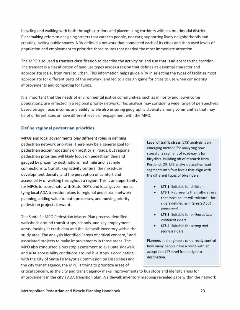
Level of traffic stress (LTS) analysis is an emerging method for analyzing how stressful a segment of roadway is for bicyclists. Building off of research from Portland, OR, LTS analysis classifies road segments into four levels that align with the different types of bike riders:
• LTS 1: Suitable for children. • LTS 2: Represents the traffic stress
that most adults will tolerate—for riders defined as interested but concerned.
• LTS 3: Suitable for enthused and confident riders.
• LTS 4: Suitable for strong and fearless riders.
Planners and engineers can directly control how many people have a route with an acceptable LTS level from origin to destination.
Metropolitan Pedestrian and Bicycle Planning Handbook 24
that impair connectivity and may impact the public’s willingness to walk. A pedestrian survey provided public input. Using data, information, and public input, the MPO developed a Pedestrian Demand Score to identify areas with the greatest walking demand. The MPO also developed a Pedestrian Infrastructure Deficiency Score to identify areas with the lowest walkability. These scores were generated using available GIS data. For the demand and deficiency scores, the MPO identified a series of indicators and weighted them by importance in contributing to a well-designed and usable pedestrian environment. To measure pedestrian demand, the MPO identified a set of 14 indicators that correlate with higher rates of walking. The MPO grouped indicators that showed high potential for walking demand into three categories:
• Neighborhood destination proximity. • Pedestrian-oriented populations. • Use mix, or mix of land uses.
The pedestrian demand potential analysis shows areas that have a density of indicators high enough to encourage and support high volumes of pedestrian traffic.
Define regional bicycle priorities
A regional priority bicycle network should connect critical regional activity centers and destinations. In many cases the network will include routes that cross jurisdictions. MPOs may also consider additional criteria for requirements for being included on the network, such as context-sensitive designs, types of facilities, whether the network is available all the time—for example, through lighting at night and snow removal in the winter—and calculations such as level of service11 and level of traffic stress.12 The regional priority bicycle network may include the range of facilities that bicyclists use, including on-road facilities and off-road trails. Many cyclists use off-road trails for portions of commuting or other transportation trips. However, in order to be included in the priority network, facilities must serve a transportation purpose. This means they should connect to important destinations and be available year-round, day and night. MPOs do not dictate facility design, which is usually set by road and trail agencies, but they can require that projects funded on the regional network meet certain standards.
Policies to incorporate walking and bicycling into all projects
Many MPOs adopt policies to require consideration of pedestrian and bicycle facilities and needs through the transportation planning process. The 2010 U.S. DOT Policy Statement on Bicycle and Pedestrian Accommodation Regulations and Recommendations states that every transportation agency, including MPOs and State DOTs, has the responsibility to improve conditions and opportunities for walking and bicycling and to integrate walking and 11 Bicycle Level of Service (BLOS) is a score that is made up of different road characteristics that influence the safety and comfort of bicycling. The identification of these gaps and barriers can form the basis for prioritizing criteria to favor projects that complete the network. 12 Low Stress Bicycling and Network Connectivity, Mineta Transportation Institute, May 2012. For discussion of the “four types of cyclists”, see: https://www.portlandoregon.gov/transportation/article/237507
Metropolitan Pedestrian and Bicycle Planning Handbook 25
bicycling into their transportation systems. This policy statement also encourages agencies to adopt similar policy statements on bicycle and pedestrian accommodation as an indication of their commitment to making bicyclists and pedestrians needs integral to their transportation system planning. To incorporate safe and convenient walking and bicycling facilities—unless they are deemed inappropriate, illegal, or extraordinarily expensive—MPOs follow routine accommodation policies for all types of transportation projects, including road, transit, and multimodal. Some MPOs use a checklist and build in review from representatives of pedestrian and bicycle interests, such as bicycle and pedestrian advisory committees. For example, the Metropolitan Transportation Commission (MTC) in San Francisco requires that every project submitted for Federal funds complete a checklist to ensure that the needs of all users have been explicitly considered at the earliest stage in the project development process. MTC has also made it easier for member jurisdictions to create a Complete Streets policy by providing sample language for cities and counties to use. Some MPOs go beyond routine accommodation and adopt a comprehensive Complete Streets process to guide how an MPO approaches project identification and definition for regional projects, and to promote broader consideration of Complete Streets throughout the region. The Complete Streets approach focuses on designing and operating the entire roadway system to enable safe access for all users, regardless of age, ability, or mode of transportation. It means that all transportation projects will improve safety and convenience for drivers, transit users, pedestrians, and bicyclists. The purpose of a Complete Streets policy is to ensure consideration of all user needs during project development and to provide some parameters, boundaries, and exceptions for applying flexibility in roadway design and operation. Following this model, the actual final design of a roadway will vary depending on context and function, but the result will be an improved facility for walking and bicycling. As with planning for any mode, MPOs may benefit from extensive coordination with State DOTs to develop Complete Streets policies so that projects implemented by a State DOT accommodate all users to an appropriate degree. Several local governments in the Des Moines Area MPO developed a Complete Streets policy using a template the MPO adopted in 2015.13 Complete Streets policies range widely, from simple resolutions stating support of the concepts, to detailed regulations discussing context, design, users, and exceptions. These policies can be particularly effective in institutionalizing the provision of pedestrian and bicycle facilities, incorporating their consideration into each stage of project development in all roadway activities. The Nashville MPO uses Complete Streets criteria as a baseline for projects, requiring consideration of pedestrians and bicyclists in every project with the expectation that accommodations will go above and beyond when possible. Complete Streets policies influence project development by ensuring accommodations for bicyclists and pedestrians, but they do not necessarily ensure construction of a complete connected system. MPOs ideally pair these policies with a systems approach to pedestrian and bicycle planning, such as with a plan to build the regional network.
13 The National Complete Streets Coalition has identified over 1100 Complete Streets policies that have been passed in the United States, including those adopted by 33 State governments, the Commonwealth of Puerto Rico, and the District of Columbia. This list includes various different types of policy statements as official commitments to a Complete Streets approach, including: legislation, resolutions, executive orders, departmental policies, policies adopted by an elected board, plans and design guidance. For more information on Complete Streets policies and implementation, see: https://smartgrowthamerica.org/program/national-complete-streets-coalition/policy-development/policy-atlas/
Metropolitan Pedestrian and Bicycle Planning Handbook 26
Before jurisdictions within the MPO compete for Federal funds, some MPO Complete Streets policies, such as at the Metropolitan Transportation Commission in San Francisco, require that they demonstrate commitment to applying those principles to locally funded projects by adopting a local Complete Streets policy.
Context-Sensitive Solutions
Context-Sensitive Solutions (CSS) promote a collaborative, multidisciplinary process that involves all stakeholders in planning and designing transportation facilities that:
• Are compatible with their setting and preserve scenic, aesthetic, historic, and environmental resources. • Meet the needs of users and stakeholders. • Integrate community objectives and values around compatibility, livability, sense of place, urban design,
cost, and environmental impacts. • Respect design objectives for safety, efficiency, multimodal mobility, capacity, and maintenance.14
CSS enhances the planning and design process by addressing objectives and considerations not only for transportation facilities but also for surrounding areas and land uses, developments, economic and other activities, and environmental conditions. The Institute of Transportation Engineers report, Designing Walkable Urban Thoroughfares: A Context Sensitive Approach, provides methods for applying the principles of CSS. Principles for effective CSS include the following:
1. Accommodating pedestrians, bicycles, transit, freight, and motor vehicles within a fine-grained urban circulation network where the allocation of right of way on individual thoroughfares is based on an urban context.
2. Providing a compact and mixed-use environment of urban buildings, public spaces and landscapes that support walking directly through the built environment and indirectly by supporting people-centric and economic activities associated with adjacent and surrounding land uses.
3. Achieving system-wide transportation capacity through a high level of multimodal network connectivity. At some level nearly every place in the built environment is walkable. Some places, such as freeways, do not allow for pedestrians. At the other extreme, public spaces such as plazas, parks, and pedestrian malls are primarily for pedestrians and generally exclude vehicles. Thoroughfares that are in between these two extremes require trade-offs between pedestrian and vehicle priority. 15
Visualization and mapping
MPOs use a variety of mapping tools to analyze, support, and share information about bicycling and walking in the region with the public. These analytical tools are useful for overlaying data such as key destinations, existing facilities, and crashes, to identify gaps in the network or other priority locations. There are a number of
14 Designing Walkable Urban Thoroughfares: A Context Sensitive Approach ITE 2010 15 Designing Walkable Urban Thoroughfares: A Context Sensitive Approach ITE 2010
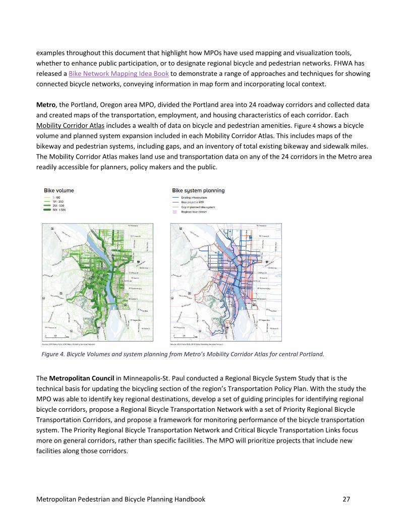
Metropolitan Pedestrian and Bicycle Planning Handbook 27
examples throughout this document that highlight how MPOs have used mapping and visualization tools, whether to enhance public participation, or to designate regional bicycle and pedestrian networks. FHWA has released a Bike Network Mapping Idea Book to demonstrate a range of approaches and techniques for showing connected bicycle networks, conveying information in map form and incorporating local context. Metro, the Portland, Oregon area MPO, divided the Portland area into 24 roadway corridors and collected data and created maps of the transportation, employment, and housing characteristics of each corridor. Each Mobility Corridor Atlas includes a wealth of data on bicycle and pedestrian amenities. Figure 4 shows a bicycle volume and planned system expansion included in each Mobility Corridor Atlas. This includes maps of the bikeway and pedestrian systems, including gaps, and an inventory of total existing bikeway and sidewalk miles. The Mobility Corridor Atlas makes land use and transportation data on any of the 24 corridors in the Metro area readily accessible for planners, policy makers and the public.
The Metropolitan Council in Minneapolis-St. Paul conducted a Regional Bicycle System Study that is the technical basis for updating the bicycling section of the region’s Transportation Policy Plan. With the study the MPO was able to identify key regional destinations, develop a set of guiding principles for identifying regional bicycle corridors, propose a Regional Bicycle Transportation Network with a set of Priority Regional Bicycle Transportation Corridors, and propose a framework for monitoring performance of the bicycle transportation system. The Priority Regional Bicycle Transportation Network and Critical Bicycle Transportation Links focus more on general corridors, rather than specific facilities. The MPO will prioritize projects that include new facilities along those corridors.
Figure 4. Bicycle Volumes and system planning from Metro’s Mobility Corridor Atlas for central Portland.
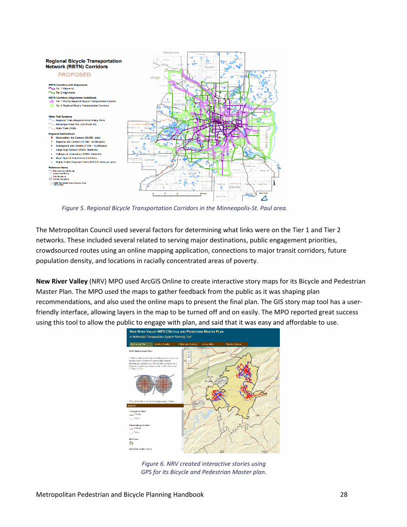
Metropolitan Pedestrian and Bicycle Planning Handbook 28
The Metropolitan Council used several factors for determining what links were on the Tier 1 and Tier 2 networks. These included several related to serving major destinations, public engagement priorities, crowdsourced routes using an online mapping application, connections to major transit corridors, future population density, and locations in racially concentrated areas of poverty. New River Valley (NRV) MPO used ArcGIS Online to create interactive story maps for its Bicycle and Pedestrian Master Plan. The MPO used the maps to gather feedback from the public as it was shaping plan recommendations, and also used the online maps to present the final plan. The GIS story map tool has a user-friendly interface, allowing layers in the map to be turned off and on easily. The MPO reported great success using this tool to allow the public to engage with plan, and said that it was easy and affordable to use.
Figure 6. NRV created interactive stories using GPS for its Bicycle and Pedestrian Master plan.
Figure 5. Regional Bicycle Transportation Corridors in the Minneapolis-St. Paul area.
Metropolitan Pedestrian and Bicycle Planning Handbook 29
Developing Regional Plans, Setting Priorities MPOs conduct a variety of regional planning activities to evaluate priorities and guide investments in infrastructure and programs. The metropolitan transportation plan (MTP) is the key document that establishes goals, objectives, performance measures and targets. It often includes policy decisions, and a strategic investment program to demonstrate how to achieve the goals. However, the continuing, cooperative and comprehensive—or 3C—planning process is ongoing and iterative.16 MPOs may create more focused pedestrian or bicycle plans and studies, which may be aspirational and are not subject to the same requirements as the fiscally constrained MTPs to identify or program funds. This section provides context for addressing walking and bicycling through the MTP process.
5.1 MTPs and Regional Pedestrian and Bicycle Plans The MTP is the foundation for an MPO’s policies and procedures. All MPOs must develop an MTP, and it must address pedestrian and bicycle safety and mobility in a region.17 A key role of the MTP is to identify long-term project needs across the region, which it translates into sets of short-term projects funded through the TIP. Bicyclists and pedestrians must be considered in the MTPs developed by each MPO and both the MTPs and projects must provide due consideration for safety and contiguous routes for bicyclists and pedestrians.18 MPOs use information on the current state of walking and bicycling and the identified needs or issues of concern that arose through public involvement and technical analysis to develop policies and goals, objectives or performance measures. MPOs can use a variety performance measures to evaluate how well the transportation system meets the needs of pedestrians and bicyclists and can measure progress toward meeting targets or benchmarks established in the regional plan to ensure planning processes are data-driven and transparent to the public. Performance measures should be relevant to the MPO as well as practical and feasible in terms of the data that is available or collectable.
16 23 CFR 450. 200 and 300
17 23 U.S.C. 134 Metropolitan Transportation Planning: The plans and TIPs for each metropolitan area shall provide for the development and integrated management and operation of transportation systems and facilities (including accessible pedestrian walkways and bicycle transportation facilities) that will function as an intermodal transportation system for the metropolitan planning area and as an integral part of an intermodal transportation system for the State and the United States.
http://www.fhwa.dot.gov/hep/guidance/ 18 23 U.S.C.217(g)
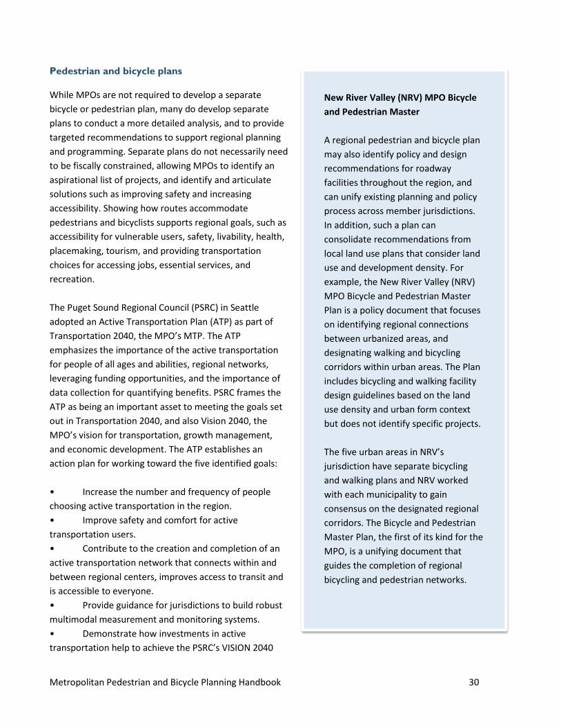
Metropolitan Pedestrian and Bicycle Planning Handbook 30
Pedestrian and bicycle plans
While MPOs are not required to develop a separate bicycle or pedestrian plan, many do develop separate plans to conduct a more detailed analysis, and to provide targeted recommendations to support regional planning and programming. Separate plans do not necessarily need to be fiscally constrained, allowing MPOs to identify an aspirational list of projects, and identify and articulate solutions such as improving safety and increasing accessibility. Showing how routes accommodate pedestrians and bicyclists supports regional goals, such as accessibility for vulnerable users, safety, livability, health, placemaking, tourism, and providing transportation choices for accessing jobs, essential services, and recreation. The Puget Sound Regional Council (PSRC) in Seattle adopted an Active Transportation Plan (ATP) as part of Transportation 2040, the MPO’s MTP. The ATP emphasizes the importance of the active transportation for people of all ages and abilities, regional networks, leveraging funding opportunities, and the importance of data collection for quantifying benefits. PSRC frames the ATP as being an important asset to meeting the goals set out in Transportation 2040, and also Vision 2040, the MPO’s vision for transportation, growth management, and economic development. The ATP establishes an action plan for working toward the five identified goals: • Increase the number and frequency of people choosing active transportation in the region. • Improve safety and comfort for active transportation users. • Contribute to the creation and completion of an active transportation network that connects within and between regional centers, improves access to transit and is accessible to everyone. • Provide guidance for jurisdictions to build robust multimodal measurement and monitoring systems. • Demonstrate how investments in active transportation help to achieve the PSRC’s VISION 2040
New River Valley (NRV) MPO Bicycle and Pedestrian Master A regional pedestrian and bicycle plan may also identify policy and design recommendations for roadway facilities throughout the region, and can unify existing planning and policy process across member jurisdictions. In addition, such a plan can consolidate recommendations from local land use plans that consider land use and development density. For example, the New River Valley (NRV) MPO Bicycle and Pedestrian Master Plan is a policy document that focuses on identifying regional connections between urbanized areas, and designating walking and bicycling corridors within urban areas. The Plan includes bicycling and walking facility design guidelines based on the land use density and urban form context but does not identify specific projects. The five urban areas in NRV’s jurisdiction have separate bicycling and walking plans and NRV worked with each municipality to gain consensus on the designated regional corridors. The Bicycle and Pedestrian Master Plan, the first of its kind for the MPO, is a unifying document that guides the completion of regional bicycling and pedestrian networks.
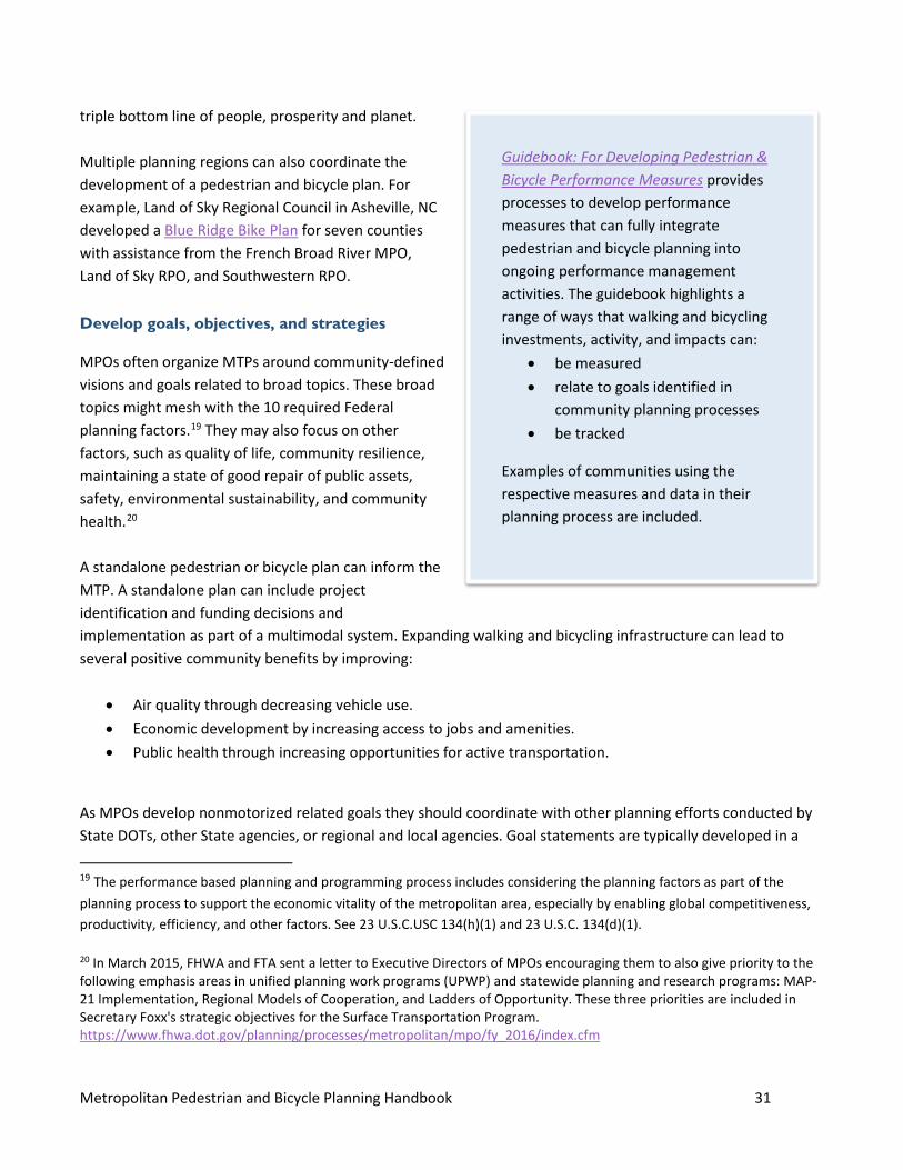
Metropolitan Pedestrian and Bicycle Planning Handbook 31
triple bottom line of people, prosperity and planet. Multiple planning regions can also coordinate the development of a pedestrian and bicycle plan. For example, Land of Sky Regional Council in Asheville, NC developed a Blue Ridge Bike Plan for seven counties with assistance from the French Broad River MPO, Land of Sky RPO, and Southwestern RPO.
Develop goals, objectives, and strategies
MPOs often organize MTPs around community-defined visions and goals related to broad topics. These broad topics might mesh with the 10 required Federal planning factors.19 They may also focus on other factors, such as quality of life, community resilience, maintaining a state of good repair of public assets, safety, environmental sustainability, and community health.20 A standalone pedestrian or bicycle plan can inform the MTP. A standalone plan can include project identification and funding decisions and implementation as part of a multimodal system. Expanding walking and bicycling infrastructure can lead to several positive community benefits by improving:
• Air quality through decreasing vehicle use. • Economic development by increasing access to jobs and amenities. • Public health through increasing opportunities for active transportation.
As MPOs develop nonmotorized related goals they should coordinate with other planning efforts conducted by State DOTs, other State agencies, or regional and local agencies. Goal statements are typically developed in a
19 The performance based planning and programming process includes considering the planning factors as part of the planning process to support the economic vitality of the metropolitan area, especially by enabling global competitiveness, productivity, efficiency, and other factors. See 23 U.S.C.USC 134(h)(1) and 23 U.S.C. 134(d)(1). 20 In March 2015, FHWA and FTA sent a letter to Executive Directors of MPOs encouraging them to also give priority to the following emphasis areas in unified planning work programs (UPWP) and statewide planning and research programs: MAP-21 Implementation, Regional Models of Cooperation, and Ladders of Opportunity. These three priorities are included in Secretary Foxx's strategic objectives for the Surface Transportation Program. https://www.fhwa.dot.gov/planning/processes/metropolitan/mpo/fy_2016/index.cfm
Guidebook: For Developing Pedestrian & Bicycle Performance Measures provides processes to develop performance measures that can fully integrate pedestrian and bicycle planning into ongoing performance management activities. The guidebook highlights a range of ways that walking and bicycling investments, activity, and impacts can:
• be measured • relate to goals identified in
community planning processes • be tracked
Examples of communities using the respective measures and data in their planning process are included.
Metropolitan Pedestrian and Bicycle Planning Handbook 32
public process that also engages interested parties, the public and stakeholders. Objectives and strategies that MPOs identify for working toward the MTP goals provide the framework for regional policy and funding decisions. The NRV MPO Master Bicycle and Pedestrian Plan goals included Mobility Connectivity, and Accessibility; Safety; Cost Efficient Use of Public Dollars, Economic Vitality; Environmental Stewardship and Public Health in their Bicycle and Pedestrian Master Plan. The Missoula MPO developed the Missoula Active Transportation Plan to support and invest in its active transportation system, trail network and public spaces.21 This plan envisions a community where citizens can safely and conveniently reach any destination using active, nonmotorized modes of transportation. Missoula intends to further develop an interconnected, continuous and universally accessible system of sidewalks, bike facilities, and trails throughout the area. Missoula’s plan includes 10 goals directly supporting nonmotorized transportation, based on the guiding principles of livability, connectivity, safety, equity, and accessibility. In Minneapolis-St. Paul, the Metropolitan Council’s plan is organized around overarching goal areas with nonmotorized modal strategies. The Metropolitan Council’s plan goes into extensive detail about how the MPO will use its position to work toward achieving its goals and objectives. These goals include the following strategies related to walking and bicycling:
• Transportation System Stewardship o Include pedestrian and bicycle facilities to support travel demand management in congested
locations. The Council supports the use of these strategies before consideration of building new or expanding highway facilities.
• Access to Destinations o Encourage investments that include provisions for bicycle and pedestrian travel. o Focus investments on completing Priority Regional Bicycle Transportation Corridors and
improving the larger Regional Bicycle Transportation Network. o Fund projects that provide for bicycle and pedestrian travel across or around physical barriers
and improve continuity between jurisdictions. o Provide or encourage reliable, cost-effective, and accessible transportation choices that provide
and enhance access to employment, housing, education and social connections for pedestrians and people with disabilities
• Competitive Economy o Invest in regional transit and bicycle systems that improve connections to jobs and opportunity,
promote economic development, and attract and retain businesses and workers on the established transit corridors.
Showing how goals connect to implementation provides the foundation for project prioritization on which MPOs can analyze all of their decisions.
21 http://www.ci.missoula.mt.us/DocumentCenter/View/23281
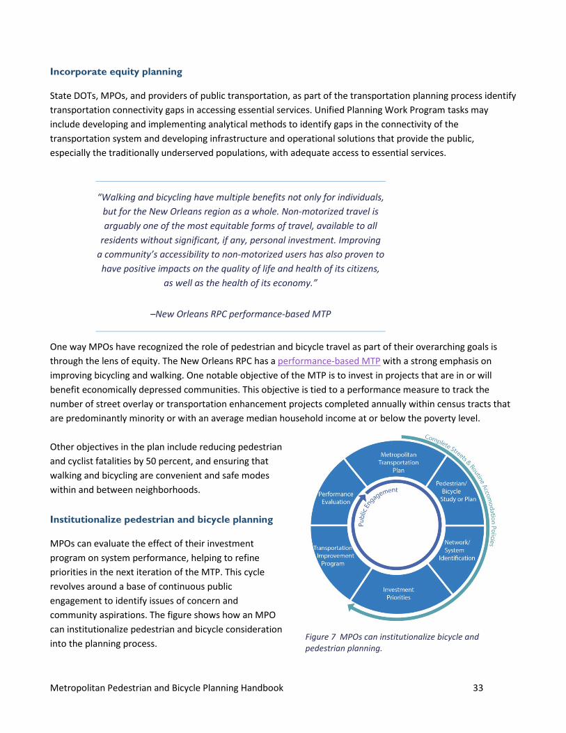
Metropolitan Pedestrian and Bicycle Planning Handbook 33
Incorporate equity planning
State DOTs, MPOs, and providers of public transportation, as part of the transportation planning process identify transportation connectivity gaps in accessing essential services. Unified Planning Work Program tasks may include developing and implementing analytical methods to identify gaps in the connectivity of the transportation system and developing infrastructure and operational solutions that provide the public, especially the traditionally underserved populations, with adequate access to essential services.
One way MPOs have recognized the role of pedestrian and bicycle travel as part of their overarching goals is through the lens of equity. The New Orleans RPC has a performance-based MTP with a strong emphasis on improving bicycling and walking. One notable objective of the MTP is to invest in projects that are in or will benefit economically depressed communities. This objective is tied to a performance measure to track the number of street overlay or transportation enhancement projects completed annually within census tracts that are predominantly minority or with an average median household income at or below the poverty level. Other objectives in the plan include reducing pedestrian and cyclist fatalities by 50 percent, and ensuring that walking and bicycling are convenient and safe modes within and between neighborhoods.
Institutionalize pedestrian and bicycle planning
MPOs can evaluate the effect of their investment program on system performance, helping to refine priorities in the next iteration of the MTP. This cycle revolves around a base of continuous public engagement to identify issues of concern and community aspirations. The figure shows how an MPO can institutionalize pedestrian and bicycle consideration into the planning process.
“Walking and bicycling have multiple benefits not only for individuals, but for the New Orleans region as a whole. Non-motorized travel is arguably one of the most equitable forms of travel, available to all
residents without significant, if any, personal investment. Improving a community’s accessibility to non-motorized users has also proven to have positive impacts on the quality of life and health of its citizens,
as well as the health of its economy.”
–New Orleans RPC performance-based MTP
Figure 7 MPOs can institutionalize bicycle and pedestrian planning.
Metropolitan Pedestrian and Bicycle Planning Handbook 34
Identify networks to improve connectivity
Regional priority networks can help MPOs think broadly about transportation and can guide regional investment strategies. A priority network may be conceptual or may identify specific routes. Using regional priority networks, MPOs analyze how a transportation system functions in communities and facilities within the region, and track progress toward improving pedestrian and bicycle accessibility and mobility to key destinations. A regional pedestrian and bicycle plan can lead to policy recommendations and can refine purpose and need, cost estimates, and funding sources for specific projects. For example, the New River Valley MPO worked with stakeholders to develop its 2014 Bicycle and Pedestrian Master Plan, which identifies a network of interconnected corridors that allow travelers to move within and between key activity centers. Identifying this network helps the MPO follow a strategic and comprehensive approach to building a nonmotorized transportation system, much the way the MPO plans for highway and public transit systems. To determine how the existing built environment influences the likelihood of pedestrian and bicycle use, the New River Valley Plan evaluated and analyzed system characteristics, including existing conditions; activity density; multimodal districts of mixed use and higher density; and the walkable and bike-able areas around multimodal transportation centers to identify a system of corridors. Once the planning process was complete the MPO was able to evaluate different design considerations with different multimodal characteristics. Missoula’s Active Transportation plan includes network attributes such as the system function, barriers to pedestrian and bicycle transportation including natural barriers or design features like difficult intersections or cul-de-sacs; safety hazards or design hazards such as sight obstructions; operational hazards such as design speed limits or high traffic volumes; and high crash rates and transit interface. These data inform project prioritization and help refine purpose and project need. Project lists with reliable cost estimates also help MPOs prioritize and phase their bicycling and walking networks and build key regional connections using a systems approach. For example, by identifying a priority network for the region, MPOs such as the Santa Fe MPO and New Orleans RPC were able to estimate the cost of completing it and identify specific priority projects that jurisdictions could implement quickly. Project prioritization lists allowed the MPO to readily respond to new funding opportunities because they had identified projects and costs. After Hurricane Katrina, the New Orleans RPC leveraged Transportation Enhancement funding from the American Recovery and Reinvestment Act because it had a list of priority projects. In the same way, the Santa Fe MPO leveraged bond funds from Santa Fe for its list of priority projects.
Delivering Safe, Comfortable, and Connected Pedestrian And Bicycle Networks: A Review Of International Practices identifies noteworthy and innovative designs, treatments, and other practices from outside the U.S. that may improve bicycle and pedestrian safety and access, and increase walking and bicycling.

Metropolitan Pedestrian and Bicycle Planning Handbook 35
Implementing Projects MPOs can use different policies and project selection criteria to ensure that nonmotorized projects and features are funded in the TIP and are included in their annual list of projects. This section includes an overview of funding sources for bicycle and pedestrian projects, and examples of performance measures for MPOs to track progress toward improving regional bicycle and pedestrian travel. Pedestrian and Bicycle Plans include policies and priorities and provide a list of proposed projects MPOs can draw from when prioritizing Federal-aid transportation funding for bike and pedestrian infrastructure. Overall, these plans represent a framework for prioritizing, identifying, and selecting bicycle and pedestrian projects for the MTP and TIP. MPOs must develop a four-year investment program called the Transportation Improvement Program (TIP), which details how the MPO will spend Federal transportation funds, including for pedestrian and bicycle investments. All Federal transportation funding programs have eligibility criteria that define the types of projects that can be funded using them, but most Federal funding sources can be used for pedestrian and bicycle projects or facilities. MPOs can develop policies that guide the project selection process. As a strategy that enhances safety and encourages all travel modes, the context-sensitive solution approach may draw upon different funding sources than conventional projects. Using a CSS approach can result in a plan that:
• Encompasses traditional and innovative solutions. • Engenders community ownership and endorsement. • Identifies opportunities to enhance community resources. • Reflects the vision and community values and meets the needs statement.22
6.1 Demonstrate local support Making sure that projects have strong local support is good practice for projects of any mode of transportation, but may be even more important for nonmotorized transportation projects because they can be smaller and not as conceptually developed as more visible large projects. Projects that are programmed into the TIP that were not developed with extensive community support or were developed long ago may encounter problems with timely delivery because of community opposition or changes to project scope. Some funding sources require that local jurisdictions such as cities, counties, and parks agencies, clearly demonstrate local support for projects they submit for Federal funds.23 Proponents should demonstrate that projects have public support and are compatible with local planning. This can be done by encouraging local
22 Designing Walkable Urban Thoroughfares: A Context Sensitive Approach, ITE 2010 23 FHWA Transportation Alternatives http://www.fhwa.dot.gov/environment/transportation_alternatives/
Metropolitan Pedestrian and Bicycle Planning Handbook 36
jurisdictions to participate in the transportation planning process, and by requiring that projects submitted for funding be included in a local plan. Some regions use a project development checklist with supporting documentation showing that the project has passed some milestones. This is good practice for any mode of transportation, but may be even more important for nonmotorized transportation projects because they can be smaller and not as conceptually developed as more visible large projects.
Establish a transportation purpose
Projects funded with Federal-aid highway program funds generally must have a transportation purpose. Off-road projects that serve a transportation purpose may be eligible under a variety of Federal-aid funding sources.24 Trails that only provide a recreational purpose are eligible under the Recreational Trails Program.25 26 Projects involving shared-use paths need to demonstrate a transportation purpose. Many paths maintain transportation and recreational purposes by connecting important destinations, and can be used for commuting, access to services, or other personal travel, making them eligible for Federal-aid funding. Considerations may include that projects meet standard widths and surface types, have continuous lighting, and include assurances that the trail will be maintained year-round, including snow removal.
6.2 Identify and leverage funding sources MPOs are often the only regional body to address funding challenges. Since many regionally important projects include some Federal funding, MPOs can help their regions find creative financing solutions and can be innovators in using Federal funding sources.
Funding set-aside
While not a requirement, some MPOs set aside a certain percentage of funding specifically for pedestrian or bicycle transportation projects. The Nashville MPO has committed 15 percent of its annual Surface Transportation Program funding to standalone pedestrian and bicycle projects. That MPO also requires that all roadway projects include accommodations for pedestrians and bicyclists. These commitments ensure Nashville
24 See Pedestrian and Bicycle Funding Opportunities at https://www.fhwa.dot.gov/environment/bicycle_pedestrian/funding/funding_opportunities.cfm 25 The Recreational Trails Program provides funds to the States to develop and maintain recreational trails and trail-related facilities for both nonmotorized and motorized recreational trail uses. Examples of trail uses include hiking, bicycling, in-line skating, equestrian use, cross-country skiing, snowmobiling, off-road motorcycling, all-terrain vehicle riding, four-wheel driving, or using other off-road motorized vehicles. http://www.fhwa.dot.gov/federalaid/projects.pdf#rtp 26 Section 217(i) of Title 23 requires that bicycle projects be "principally for transportation rather than recreation purposes", with the exception of the RTP under which projects may be for recreational use. MAP-21 revised 23 U.S.C. 133(b) (STP) and added transportation alternatives and recreational trail projects as eligible STP projects and enacted §213(b) (TAP) to allow eligibility for recreational trails projects eligible under the RTP, which conflicts with 23 U.S.C. 217(i). Effective under MAP-21, the requirement in 23 U.S.C. 217(i) does not apply to bicycle facilities using STP or TAP funds. However, Section 217(i) continues to apply to bicycle facilities using other Federal-aid highway program funds (NHPP, HSIP, CMAQ, etc.). Note that Section 217(i) makes the transportation requirement applicable only to bicycle-specific projects; it does not apply to any other trail use or transportation mode.
Metropolitan Pedestrian and Bicycle Planning Handbook 37
is making progress toward improving walking and bicycling conditions.
Funding sources
MPOs can use a variety of Federal funding sources toward projects for bicycling and walking. Tables developed by FHWA and FTA show that existing surface transportation funding sources can be used for a range of pedestrian and bicycle plans, projects, and programs, and also clarify eligible use of transit funding sources. The FHWA Bicycle and Pedestrian Funding, Design, and Environmental Review: Addressing Common Misconceptions document further clarifies the wide variety of Federal funding available for projects related to walking and bicycling. Projects that receive Federal funds must include a local match. For FHWA fund programs described below, local project sponsors usually must contribute at least 20 percent of the total project cost.27 For FTA projects, this amount is 10 percent. MPOs may create a policy that requires a higher match in order to spread Federal funding to more or larger projects. The most common funding sources used for pedestrian and bicycle projects include: Surface Transportation Block Grant Program (STBG): Formerly known as the Surface Transportation Program, this is the most flexible source of Federal funds that MPOs can program. There are no restrictions on modes or primary objectives of projects funded with STBG. MPOs may use STBG funds to preserve and improve conditions and performance on any Federal-aid highway, bridge and tunnel projects on any public road, pedestrian and bicycle infrastructure, and transit capital projects, including intercity bus terminals. This flexibility means MPOs can use STBG to implement projects that support walking and bicycling. See https://www.fhwa.dot.gov/specialfunding/stp/160307.cfm for more information. Transportation Alternatives Set-aside: The TA Set-Aside is the single largest source used to fund improvements for walking and bicycling. The TA Set-Aside is not limited to funding pedestrian and bicycle projects but it is often used this way by MPOs. It can also fund recreational trail facilities and trailheads, safe routes to school projects, viewing areas, historic preservation, and environmental work related to transportation. Congestion Mitigation and Air Quality Improvement Program (CMAQ): The CMAQ program funds projects that will help improve a region’s performance on measures of air pollution from mobile sources: cars and trucks. The program is available in regions that are in either nonattainment or maintenance for air pollution defined by the requirements of the Clean Air Act. Projects can reduce pollution by reducing idling and congestion or by reducing vehicle miles traveled through shifts to public transit, ridesharing, walking, and bicycling. Some
27 An upward sliding scale adjustment is available to States having public lands (23 U.S.C. 120).
San Diego County—served by SANDAG—is a self-help county, meaning it can establish voter-approved sales or other taxes. The county has enacted TransNet, a sales tax that funds roads, transit, active transportation, and smart growth. The county has also instituted a requirement that all road projects funded with the sales tax include provisions for active transportation, which ensures that any new investment in roads also includes some improvements for bicyclists and pedestrians.
Metropolitan Pedestrian and Bicycle Planning Handbook 38
pedestrian and bicycle projects may be eligible for CMAQ funds if they demonstrate a reduction in emissions. MPOs have particularly used CMAQ to fund projects that provide bicycle access to public transit or schools, or that fill critical system gaps.
Innovative Financing
Many regions are successful at leveraging Federal funds by finding new ways to finance the local match for projects. In California, many counties administer a sales tax to fund transportation improvements. MPOs like MTC and SANDAG use these funds to implement pedestrian and bicycle strategies. Some MPOs also enter into funding partnerships with public health authorities, including CDC. Most of these funds have gone toward building planning capacity for active transportation. The Nashville MPO and SANDAG used grants from CDC for pedestrian and bicycle data collection.
6.3 Establish project selection criteria that further the regional strategy States and MPOs establish criteria to select and prioritize projects. For urbanized areas with populations over 200,000, the MPO(s) select(s) Surface Transportation Block Grant and Transportation Alternatives projects in consultation with the State. For small (less than 200,000 population) MPOs the State is responsible for selecting projects (23 U.S.C. 133(h)(4)). The State may make these funds available for projects anywhere within the metropolitan planning area boundaries of an MPO serving an urbanized area with a population less than or equal to 200,000. For small urban areas not within MPOs, the State may make these funds available for projects anywhere within the municipal boundaries of the applicable small urban area, for example, within a town or township. All TA Set-Aside funds must be used for eligible projects that are submitted by eligible entities and chosen through a competitive project selection process.28 States administer funds suballocated to small urban areas and nonurban areas—areas with populations below 200,000—through a competitive process.29 See the TA Set-Aside Guidance for more information on the competitive project selection process. The Transportation Alternatives Program Performance Management Guidebook provides sample performance objectives and measures that States, Metropolitan Planning Organizations (MPOs), and project sponsors may consider as they administer, implement, and evaluate TA projects and program outcomes. Some regions have developed policies like Complete Streets and routine accommodation requiring that projects include pedestrian and bicycle elements, while other policies encourage the provision of nonmotorized facilities through selection criteria. MPOs can use these criteria when scoring projects quantitatively and recognizing safety improvements for walking and bicycling and that help to complete a regional network. DVRPC created a tool called RideScore, which provides input into project prioritization and can identify transit stations that need investments in bicycle facilities. RideScore rates stations on criteria such as transit volume, connectivity,
28 TAP Guidance https://www.fhwa.dot.gov/environment/transportation_alternatives/guidance/guidance_2016.cfm#CompetitiveSelect 29 (23 U.S.C. 133(h)(4))
Metropolitan Pedestrian and Bicycle Planning Handbook 39
population, employment, nearby destinations and existing facilities.
Priority development areas
Small area planning and zoning ordinances achieve land use and transportation objectives at a variety of scales. Transportation planners ensure that pedestrian and bicycle improvements complement land development by coordinating with agencies responsible for land and other types of development and urban design activities. MPOs often focus planning efforts on access to transit or other intermodal connections. Defining priority areas allows the MPO to channel its resources to benefit the most people, and improve their economies and quality of life. The New River Valley MPO Master Bicycle and Pedestrian Plan identified through-corridors connecting activity centers and placemaking corridors in activity centers. Activity centers frequently have transportation challenges related to congestion, parking, and transit connections. Investing in improvements to the pedestrian network within these areas and connecting activity centers to walking and bicycle networks can help relieve transportation challenges. Many regions have adopted form-based code, a land development regulation that includes specific design qualities detailing the how the inclusion of pedestrian and bicycle improvements will be addressed with different types of land use.
Safety
MPOs can use selection criteria to prioritize projects that are expected to improve walking and bicycling safety either by prioritizing areas with documented crashes or other safety concerns, or through projects that incorporate proven safety countermeasures.30 For example, the New Orleans RPC scoring system provides points to projects located in documented crash hotspots.
Priority corridors or network
MPOs that have defined regional priority corridors or networks can use selection criteria to prioritize among pedestrian and bicycle-specific projects, and to help ensure that routine roadway projects that would help build or improve the designated network are more likely to be funded sooner. For example, SANDAG gives weight to projects that provide “local connections of regional importance.” These projects address deficiencies on routes listed on the regional network. The Metropolitan Council in the Minneapolis area has a regional bicycle study that includes a tiered regional bicycle network, which provides extra weight to projects first on the primary network first, then on the secondary network.
Equity
MPOs have a responsibility to ensure that the process and outcomes of the transportation-planning process neither unfairly deprive any person of benefit, nor create undue burden on protected groups, based on race, color, national origin, sex, age, or disability. MPOs can use selection criteria to ensure that transportation
30 FHWA Proven Safety Countermeasures http://safety.fhwa.dot.gov/provencountermeasures/
Metropolitan Pedestrian and Bicycle Planning Handbook 40
investments, including those in walking and bicycling, are distributed to communities traditionally underrepresented in the planning process. For example, the New Orleans RPC recognizes that safe and attractive alternative transportation options are very important because the region has a high number of households that do not have access to a vehicle. The New Orleans MTP gives higher weight during project selection to bicycle and pedestrian projects in low-income communities.
6.4 The Transportation Improvement Program A key responsibility of MPOs is to produce the annual Transportation Improvement Program (TIP). The TIP documents the short-term (4 year) programming plan of the MPO and must show how it is consistent with the priorities identified in the region’s Metropolitan Transportation Plan (MTP).
Connection between the TIP and the plan and programming criteria
The TIP includes capital projects that are generally new, expanded or involve a significantly improved facility or service that may involve planning, environmental studies, design, right-of-way acquisition, construction, or purchasing transit equipment. The TIP reflects the priorities of the MPO as included in the MTP. These priorities must address Federal and State requirements, local government mandates, interests, and concerns, and public travel needs. Guided by these considerations, the TIP represents the implementation of the planning process that MPOs carry out for their regions. A TIP ties the objectives and strategies identified in the region’s MTP to projects being selected to receive Federal funding in the 4-year TIP timeframe. The TIP identifies funding amounts and types of projects included in the 4-year program and also documents recently implemented projects. The TIP should also describe progress toward implementing performance measures.
Annual list of projects
MPOs must produce a list of all projects that received funding during the previous fiscal year. A good practice in accounting for projects is to identify the primary mode served by each project. The annual list of projects can be summarized by tallying the amount spent on different modes of transportation. Providing the public with information about how many projects and how much funding is going toward pedestrian and bicycle projects improves decisionmaking for the expenditure of future funds. It also allows the public a chance to review the region’s progress on implementing strategies identified in its regional plan.
4-year program of projects
The largest part of a TIP is the 4-year program of projects. This is a list of all projects selected to receive any Federal funds, though some MPOs choose to include all projects being programmed in the region. The TIP details which projects are to receive Federal funds and by what funding source. Each entry in the 4-year program includes a project description. This description should include the project’s location and termini, route identification if it is on a roadway, work description, local project sponsor, total project cost, and anticipated Federal funds per fiscal year.
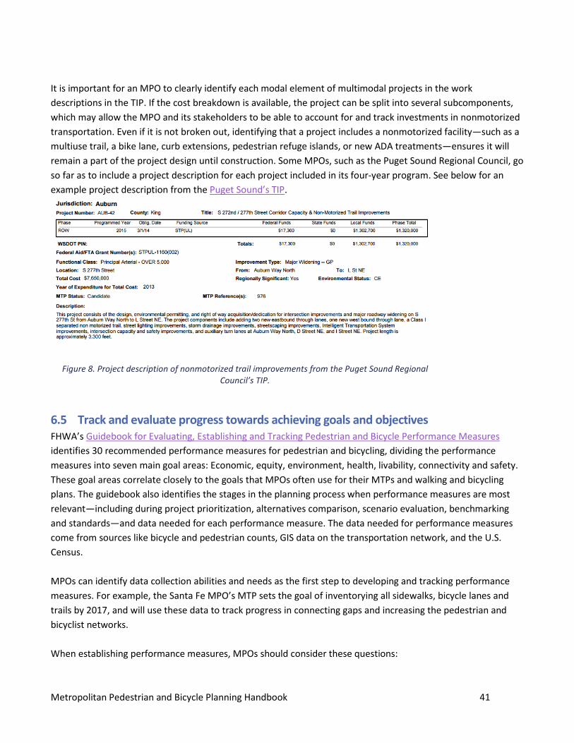
Metropolitan Pedestrian and Bicycle Planning Handbook 41
It is important for an MPO to clearly identify each modal element of multimodal projects in the work descriptions in the TIP. If the cost breakdown is available, the project can be split into several subcomponents, which may allow the MPO and its stakeholders to be able to account for and track investments in nonmotorized transportation. Even if it is not broken out, identifying that a project includes a nonmotorized facility—such as a multiuse trail, a bike lane, curb extensions, pedestrian refuge islands, or new ADA treatments—ensures it will remain a part of the project design until construction. Some MPOs, such as the Puget Sound Regional Council, go so far as to include a project description for each project included in its four-year program. See below for an example project description from the Puget Sound’s TIP.
6.5 Track and evaluate progress towards achieving goals and objectives FHWA’s Guidebook for Evaluating, Establishing and Tracking Pedestrian and Bicycle Performance Measures identifies 30 recommended performance measures for pedestrian and bicycling, dividing the performance measures into seven main goal areas: Economic, equity, environment, health, livability, connectivity and safety. These goal areas correlate closely to the goals that MPOs often use for their MTPs and walking and bicycling plans. The guidebook also identifies the stages in the planning process when performance measures are most relevant—including during project prioritization, alternatives comparison, scenario evaluation, benchmarking and standards—and data needed for each performance measure. The data needed for performance measures come from sources like bicycle and pedestrian counts, GIS data on the transportation network, and the U.S. Census. MPOs can identify data collection abilities and needs as the first step to developing and tracking performance measures. For example, the Santa Fe MPO’s MTP sets the goal of inventorying all sidewalks, bicycle lanes and trails by 2017, and will use these data to track progress in connecting gaps and increasing the pedestrian and bicyclist networks. When establishing performance measures, MPOs should consider these questions:
Figure 8. Project description of nonmotorized trail improvements from the Puget Sound Regional Council’s TIP.
Metropolitan Pedestrian and Bicycle Planning Handbook 42
1. Does the performance measure on its own adequately monitor progress towards an identified objective?
2. Does the MPO or identified partners, such as cities and counties, have the technical capability to measure?
3. How will the MPO or identified partners measure?
MPOs should use performance measures at a scale large enough to characterize the state of bicycling and walking in region. Sample performance measures commonly used by MPOs to track progress on walking and bicycling include:
• Access to destinations and employment centers. • Economic data: Retail impact, sales tax, job creation, and land value. • Facility inventories: Inventory miles of sidewalks and bicycle lanes, track gaps, and track completion
towards network goals or system completion. • Mode split: use combination of counts and U.S. Census data, can track this data at smaller scale on
corridors that are highly used for walking and biking. • Number of crashes: Crash rates, hotspots, and areas that need improvement. • Pedestrian and bicycle volume: Bicycle and pedestrian counts—automated, seasonal, site specific—track
changes in these modes, validate models, and justify investments. • Percent of low-income population served by bicycling, walking, and transit. • Percent of population served by walking and bicycling networks.
For each of the performance areas above, MPOs need to:
1. Gather data to determine the current status of each performance objective. 2. Set targets for improving each area. 3. Continue to track and update progress for each area.
It is particularly important to track before-and-after outcomes for new walking and bicycling projects, in order to demonstrate the positive impacts of improving these modes beyond simply creating better cycling and walking facilities.

Metropolitan Pedestrian and Bicycle Planning Handbook 43
Keys to Success This section highlights ways that MPOs “go above and beyond” minimum requirements for pedestrian and bicycle planning, to build successful programs. Some of these activities are not Federal requirements, but many MPOs interviewed found them useful for achieving their goals while also advancing pedestrian and bicycle transportation throughout their region. Many of these activities are scalable, meaning that there are different ways that MPOs can approach them, depending on experience and resources.
Develop a regional pedestrian and bicycle plan MPOs are not required to develop regional pedestrian and bicycle plans, but these plans are a very useful way to analyze pedestrian and bicycle needs throughout a region and identify projects and strategies to best address them. Conducting a regional pedestrian and bicycle plan allows the MPO to devote more attention to nonmotorized needs than may be available during the MTP update process. An MPO can use the results of the regional pedestrian and bicycle plan to inform future MTP updates and TIP project selection cycles. All MPOs profiled in this handbook indicated that the regional pedestrian and bicycle planning process helped them identify projects and clarify priorities for nonmotorized travel in the region. However, planning is continuous and comprehensive; it does not stop with the creation of a single plan or set of prioritizing criteria for programming funds. Effective MPOs institutionalize the full practice of planning, programming and evaluating multimodal transportation, including nonmotorized transportation. There is no correct starting point for this continuous feedback loop. It may begin with the definition of policies and strategies to support better facilities for walking and bicycling in the MTP, leading to the creation of a regional pedestrian or bicycle plan, which in turn informs selection criteria by which projects are programmed for funding in the TIP. The MPO can evaluate these projects using before-and-after count data and other analysis, which can in turn inform the next iteration of the MTP or planning study, and the development of prioritizing criteria in future years.
7.1 Tie objectives for pedestrians and bicycles to broad regional goals in the MTP MPOs often organize MTPs around community defined visions and goals related to broad topics such as quality of life, economic development, community resilience, maintaining a state of good repair of public assets, safety, environmental sustainability, and community health. These broad goals are typically not specific to any travel mode; there are multiple ways to work toward these goals, including using pedestrian and bicycle related objectives and strategies. It can be effective for MPOs to include pedestrian and bicycle objectives and strategies when determining how to work toward regional goals, for two primary reasons. First, this approach demonstrates how pedestrian and bicycle investments and strategies contribute to the comprehensive approach to improving mobility and accessibility throughout the region. Second, this approach helps to focus the pedestrian and bicycle projects and
Metropolitan Pedestrian and Bicycle Planning Handbook 44
activities that the MPO does undertake, so that they work together with projects for other modes toward a clearly defined purpose. MPOs need to think about how their decisions make the best use of constrained resources, and using broad regional goals is a good way to lead to more focused and strategic pedestrian and bicycle investments.
7.2 Engage stakeholders on an ongoing basis MPOs use robust stakeholder engagement to help shape priorities, verify data collection results and
assumptions, demonstrate public support for investments, and provide valuable information about current travel conditions. While stakeholder engagement is an important component of regional planning in general, it plays a unique role in planning for nonmotorized modes, as some of these users have been traditionally underrepresented in planning processes, and often are the most vulnerable users of the roadway. Key stakeholders and partners may include municipal and community groups, transit, law enforcement, public health, disability/accessibility commissions, community interest and advocacy groups representing diverse/minority/low income communities, and business groups.
7.3 Prioritize data collection Transportation planning decisions in all modes are increasingly based on quantitative data. MPOs are best able to fully consider pedestrian and bicycle transportation when they have information on pedestrian and bicycle activity (e.g., counts of how many and where people walk and bicycle). Many agencies getting started with counts or those with fewer resources will select a few key locations to count manually, using staff or volunteers. More sophisticated programs may include more locations, or more frequent counts, or use of automated counting technologies. Whether the MPOs are collecting data themselves or supporting local governments or other agencies with data collection, they increasingly use pedestrian and bicycle count data to estimate user demand, prioritize projects, evaluate successes, and quantify impacts.
7.4 Define, prioritize, and estimate costs to build out a regional bicycle and pedestrian system
Many MPOs find it useful to identify and plan for priority regional pedestrian and bicycle network, using the process to help focus resources to make sure facilities are accessible; connect key destinations; and support transit. Networks allow the MPO to plan for a system of pedestrian and bicycle routes in much the same way
The Portland Metro’s Regional Transportation Plan includes a goal for equity, with objectives related to environmental justice, coordinated human services transportation needs, housing diversity, and reducing the share of households that spend more than 50 percent of their income on housing and transportation. The MPO will measure progress towards these goals with these targets: • Reducing the average
household combined cost of housing and transportation by 25 percent by 2040.
• Increasing access for vulnerable populations—by 50 percent compared to 2005—to essential places within 30 minutes of bicycling and transit.
Metropolitan Pedestrian and Bicycle Planning Handbook 45
that MPOs plan for transit systems and highway systems. As MPOs shift to a performance-based approach, identifying a priority network can provide the public and decisionmakers a clear objective to work toward. The network identification process can assist MPOs in prioritizing investments to fill gaps in existing facilities, and ensure access to important destinations, such as jobs, schools, healthcare, commercial centers, transit, and important recreation areas. By proactively prioritizing and estimating costs to build network segments, MPOs are well prepared to move projects forward in the TIP, and to take advantage of new or unexpected funding opportunities. See Costs for Pedestrian and Bicycle Infrastructure Improvements at http://www.pedbikeinfo.org/data/library/details.cfm?id=4876.
7.5 Use MPO influence to enhance walking and bicycling throughout the region MPOs play an important role in convening multiple jurisdictions and agencies, and in programming Federal funds. MPOs can use their influence to improve walking and bicycling throughout their regions by defining funding eligibility and priorities, providing a forum for regional coordination on issues—e.g., consistency of facility design and network continuity—and using Federal metropolitan planning funds to improve data collection for pedestrians and bicyclists. MPOs can also make sure that they and other agencies throughout the region consider pedestrians and bicyclists when working to balance multiple needs and priorities, whether by developing and supporting Complete Streets policies, considering roadway resurfacing programs, or approaching studies on other topics such as freight or transit. MPOs can also use their role to coordinate information sharing among the jurisdictions within the MPO, so that neighboring jurisdictions can see how their existing and proposed infrastructure relates to one other. For example, if one jurisdiction is planning a bike lane on a corridor up to the town line, the neighboring jurisdiction might prioritize planning to connect to or extend the facility.
7.6 Establish project selection and funding criteria that reflect regional priorities and analysis
In order to implement pedestrian and bicycle-related goals and strategies from the MTP, many MPOs develop project selection and funding criteria that ensure that they prioritize and fund projects that reflect regional priorities and analysis from the MTP or bicycle and pedestrian planning study. This may include prioritizing among specific pedestrian and bicycle projects, as well as incentives for all projects to include or consider pedestrian and bicycle facilities. MPOs can establish strong TIP project selection and funding criteria by awarding points to projects that include bicycle and pedestrian elements. Specifically, this could mean awarding more points for bicycle and pedestrian projects on the regional network or for projects that improve safety in crash hotspots. MPOs can also use criteria to encourage other priorities, such as awarding points for projects with count data, or awarding points for projects that improve access for low-income communities.
7.7 Identify and use innovative funding strategies The most successful MPOs use a wide range of available funding sources to complete projects that further the regional pedestrian and bicycle objectives. Most Federal funding sources are available for use on pedestrian and
Metropolitan Pedestrian and Bicycle Planning Handbook 46
bicycle projects, beyond the STP set-aside funds—formerly the Transportation Alternative Program. Because STP funds are inherently flexible, some MPOs use them toward standalone pedestrian and bicycle transportation projects, or to build nonmotorized facilities as part of multimodal roadway projects. Many MPOs have also found ways to leverage other public and private funding sources, such as grants from public health agencies interested in active transportation, to stretch their funds for projects to support walking and bicycling.
Metropolitan Pedestrian and Bicycle Planning Handbook 47
Appendix A: Background and Context This section discusses legal requirements for MPOs in planning for walking and bicycling, and the broader relationship of walking and bicycling to U.S. DOT priorities.
Federal Planning Requirements and Priorities Below are some of the Federal requirements that guide MPO activities related to planning for walking and bicycling.
State and metropolitan planning requirements
MPO activities are subject to specific statutory provisions. The two Federal requirements listed below involve the incorporation of pedestrian and bicycle projects and considerations into Statewide and metropolitan long range planning. 23 U.S.C. 217 (g) Planning and Design General: Bicyclists and pedestrians shall be given due consideration in the comprehensive transportation plans developed by each Metropolitan Planning Organization and State in accordance with sections 134 and 135, respectively. Bicycle transportation facilities and pedestrian walkways shall be considered, where appropriate, in conjunction with all new construction and reconstruction of transportation facilities, except where bicycle and pedestrian use are not permitted. Safety considerations: Transportation plans and projects shall provide due consideration for safety and contiguous routes for bicyclists and pedestrians. Safety considerations shall include the installation, where appropriate, and maintenance of audible traffic signals and audible signs at street crossings. 23 U.S.C. 134 Metropolitan Transportation Planning
• General requirements – The plans and TIPs for each metropolitan area shall provide for the development and integrated management and operation of transportation systems and facilities (including accessible pedestrian walkways and bicycle transportation facilities) that will function as an intermodal transportation system for the metropolitan planning area and as an integral part of an intermodal transportation system for the State and the United States.
ADA and Section 504 Title II of the Americans with Disabilities Act (ADA) requires that State and local governments ensure that persons with disabilities have access to the pedestrian routes in the public right of way. As part of this requirement, whenever State or local governments alter streets, roadways, or highways, they must upgrade the pedestrian walkways to be universally accessible (e.g., providing curb ramps that meet the latest accessibility standards). This requirement is intended to ensure the accessibility and usability of the pedestrian walkway for persons with disabilities. An alteration is a change that could affect the usability of all or part of a building or facility. Alterations of streets, roads, or highways include activities such as reconstruction, rehabilitation,
Metropolitan Pedestrian and Bicycle Planning Handbook 48
resurfacing, widening, and projects of similar scale and effect. Because MPOs do not typically own streets and other transportation facilities, they are not directly responsible for providing accessible routes. However, all projects planned and programmed through the MPO process must meet or exceed the requirements of the ADA. It is therefore imperative for MPO staff to understand these requirements and to assist local governments to implement them. By developing pedestrian plans, policies, and strategies that integrate efforts to retrofit the transportation system to become compliant with the ADA, MPOs can accelerate local and State government progress at meeting their obligations under the law. More information on ADA compliance is available on the FHWA Civil Rights program site. State and local governments also develop inventories of accessible pedestrian facilities as part of developing their ADA Transition Plans that guide the implementation of modifications to facilities to make them accessible to individuals with disabilities. The ADA requires public agencies with more than 50 employees to make a transition plan. 28 CFR §35.150(d). The transition plan must include a schedule for providing access features, including curb ramps for walkways. 28 CFR §35.150(d)(2). The schedule should first provide for pedestrian access upgrades to State and local government offices and facilities, transportation, places of public accommodation, and employers, followed by walkways serving other areas. 28 CFR §35.150(d)(2). The transition plan should accomplish the following four tasks:
1. identify physical obstacles in the public agency's facilities that limit the accessibility of its programs or activities to individuals with disabilities;
2. describe in detail the methods that will be used to make the facilities accessible; 3. specify the schedule for taking the steps necessary to upgrade pedestrian access to meet ADA and
Section 504 requirements in each year following the transition plan; and 4. indicate the official responsible for implementation of the plan. 28 CFR §35.150(d)(3). (9-12-06)
U.S. DOT priorities Planning for walking and bicycling supports many U.S. DOT goals. This section briefly discusses several current U.S. DOT priorities that relate to walking and bicycling, including improving safety, routine accommodation, network completion, equity, health, and the environment.
Routine accommodation
The 2010 U.S. DOT Policy Statement on Bicycle and Pedestrian Accommodation Regulations and Recommendations states: The DOT policy is to incorporate safe and convenient walking and bicycling facilities into transportation projects. Every transportation agency, including DOT, has the responsibility to improve conditions and opportunities for walking and bicycling and to integrate walking and bicycling into their transportation systems. Because of the numerous individual and community benefits that walking and bicycling provide — including health, safety, environmental, transportation, and quality of life — transportation agencies are encouraged to go beyond minimum standards to provide safe and convenient facilities for these modes.
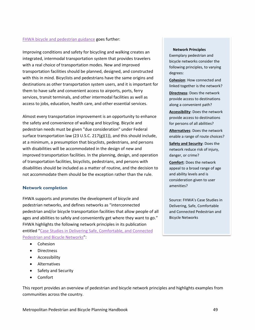
Metropolitan Pedestrian and Bicycle Planning Handbook 49
FHWA bicycle and pedestrian guidance goes further: Improving conditions and safety for bicycling and walking creates an integrated, intermodal transportation system that provides travelers with a real choice of transportation modes. New and improved transportation facilities should be planned, designed, and constructed with this in mind. Bicyclists and pedestrians have the same origins and destinations as other transportation system users, and it is important for them to have safe and convenient access to airports, ports, ferry services, transit terminals, and other intermodal facilities as well as access to jobs, education, health care, and other essential services. Almost every transportation improvement is an opportunity to enhance the safety and convenience of walking and bicycling. Bicycle and pedestrian needs must be given "due consideration" under Federal surface transportation law (23 U.S.C. 217(g)(1)), and this should include, at a minimum, a presumption that bicyclists, pedestrians, and persons with disabilities will be accommodated in the design of new and improved transportation facilities. In the planning, design, and operation of transportation facilities, bicyclists, pedestrians, and persons with disabilities should be included as a matter of routine, and the decision to not accommodate them should be the exception rather than the rule.
Network completion
FHWA supports and promotes the development of bicycle and pedestrian networks, and defines networks as “interconnected pedestrian and/or bicycle transportation facilities that allow people of all ages and abilities to safely and conveniently get where they want to go.” FHWA highlights the following network principles in its publication entitled “Case Studies in Delivering Safe, Comfortable, and Connected Pedestrian and Bicycle Networks”:
• Cohesion • Directness • Accessibility • Alternatives • Safety and Security • Comfort
This report provides an overview of pedestrian and bicycle network principles and highlights examples from communities across the country.
Network Principles Exemplary pedestrian and bicycle networks consider the following principles, to varying degrees:
Cohesion: How connected and linked together is the network?
Directness: Does the network provide access to destinations along a convenient path?
Accessibility: Does the network provide access to destinations for persons of all abilities?
Alternatives: Does the network enable a range of route choices?
Safety and Security: Does the network reduce risk of injury, danger, or crime?
Comfort: Does the network appeal to a broad range of age and ability levels and is consideration given to user amenities?
Source: FHWA’s Case Studies in Delivering, Safe, Comfortable and Connected Pedestrian and Bicycle Networks
Metropolitan Pedestrian and Bicycle Planning Handbook 50
Safety U.S. DOT is committed to making safe walking and biking available for all Americans, regardless of age, income, or ability. In 2014, Secretary Foxx launched the Safer People, Safer Streets Initiative, through which U.S. DOT is providing new resources and research, highlighting existing tools, and engaging stakeholders at many levels to encourage safety in and around streets, including bus stops, transit stations, and other multimodal connections. The FHWA Office of Safety also provides many resources, programs and materials for use in improving pedestrian and bicyclist safety. The 2012 law, Moving Ahead for Progress in the 21st Century Act (MAP-21), sets new requirements for MPOs to begin developing a performance-based approach to transportation planning. This includes a requirement that the U.S. DOT develop national performance measures for safety and a requirement for State DOTs and MPOs to work together to integrate performance measures, monitoring and target setting for safety into their long range plans. MAP-21 establishes a broad national goal for safety: “to achieve a significant reduction in traffic fatalities and serious injuries on all public roads.” Some MPOs also choose to incorporate other public health concerns and emergency preparedness, within the scope of safety.
Equity The U.S. DOT recognizes the importance of improving economic opportunity by providing a range of accessible transportation options to sites of opportunity. Transportation, economic opportunity, and mobility are deeply interconnected. Traditionally underserved communities, including low-income populations, the young, old, people with disabilities, and some minority populations may rely more on walking and bicycling and access to transit than the population at large. Providing for safe and connected bicycle and pedestrian networks that serve public transit stations and other key destinations gives everyone the ability to take advantage of economic opportunities, access essential services and schools, and reduce the share of their income devoted to transportation. The U.S. DOT has begun a policy initiative called Ladders of Opportunity that includes pilot programs dedicated to closing the gap in opportunity through transportation investments. U.S. DOT also is subject to the Presidential Order on environmental justice under Title VI of the Civil Rights Act. MPOs can help local public officials understand how Title VI and environmental justice requirements improve planning and decision making. To certify compliance with Title VI and address environmental justice, MPOs need to:
• Enhance their analytical capabilities to ensure that the long range transportation plan and the transportation improvement program (TIP) comply with Title VI.
• Identify residential, employment, and transportation patterns of low-income populations and minority populations so that their needs can be identified and addressed, and the benefits and burdens of transportation investments can be fairly distributed.
The FHWA Environmental Justice program provides examples of noteworthy practices related to environmental
Metropolitan Pedestrian and Bicycle Planning Handbook 51
justice, including some that are specific to walking and bicycling. This handbook includes a few examples from MPOs that are incorporating equity into their planning and programming process with regard to pedestrian and bicycle planning and programming.
Health
The U.S. DOT is committed to supporting transportation investments that improve public health. The Center for Disease Control and Prevention’s (CDC) Transportation and Health page outlines the connections between public health and transportation. The CDC notes safe pedestrian and bicycling networks can help increase physical activity levels and help reduce risks of obesity and related diseases. Other priority areas address other health benefits of safe bicycle and pedestrian networks such as reduced chances of injury, improved air quality, and environmental justice implications. Many MPOs address public health through their planning and policies. In order make more information available on how transportation relates to public health the U.S. DOT and the CDC have developed a transportation and health tool (THT). The goals of this project are to:
• Help transportation decisionmakers understand many of the issues in play at the intersection with public health.
• Inform health-supportive State and regional policies and project decisions. • Strengthen collaborations between transportation and public health sectors.
The THT is an online tool and resource that contains indicators and related strategies that can allow MPOs to work towards better health outcomes. The tool contains region- and State-specific data allowing MPOs to compare themselves to peers on several indicators including those related to walking and bicycling.
Environment
Supporting walking and bicycling is consistent with U.S. DOT priorities on reducing greenhouse gas (GHG) emissions and the associated impacts on the environment. The U.S. DOT recognizes that transportation is the source of close to 30 percent of all greenhouse gas (GHG) emissions in the United States. For this reason, it has developed several resources to help communities develop GHG mitigation strategies. One of these strategies is to reduce travel activity by reducing growth in vehicle-miles traveled by shifting drivers to other cleaner modes such as bicycling, walking, and public transit. FHWA also supervises the Congestion Mitigation and Air Quality Improvement (CMAQ) Program that funds transportation projects that reduce emissions of pollutants in metropolitan areas that have previously been or are currently out of attainment for various criteria pollutants. MPOs program CMAQ funding, and projects that increase bicycling and walking are eligible to receive CMAQ funding.

Metropolitan Pedestrian and Bicycle Planning Handbook 52
Appendix B: Metropolitan Plans The authors of this handbook reviewed the following plans and MPO policies to inform much of the content of this handbook. Inclusion in this review does not imply FHWA endorsement of these planning and policy documents nor does it negate the value of those not included. Augusta MPO Bicycle and Pedestrian Plan (2012) Buffalo Bicycle Facility Master Plan Update (ongoing) Cheyenne MPO (2012) Delaware Valley Regional Planning Commission RideScore and Bicycle and Pedestrian Count Program Land of Sky Regional Council’s Blue Ridge Bike Plan (2013) Lincoln MPO Long Range Plan (2011) Metropolitan Council 2040 Transportation Policy Plan (2015) and Twin Cities Regional Bicycle System Study (2014) Metropolitan Transportation Commission Plan Bay Area (2013) and Regional Bicycle Network Plan (2009) Mid-Ohio Regional Planning Commission Complete Streets Policy and Toolkit (2010) Missoula MPO Active Transportation Plan (2011) and Long Range Transportation Plan (2012) Nashville 2035 Regional Transportation Plan (2010) and Bicycle and Pedestrian Study (2009) Nashua Regional Planning Commission Regional Bicycle and Pedestrian Plan (2015) New Orleans Regional Planning Commission Metropolitan Transportation Plan (2015) New River Valley MPO Bicycle and Pedestrian Master Plan (2014) Portland Metro Mobility Corridor Atlas and Regional Transportation Plan (2014) Puget Sound Regional Council Active Transportation Plan (2014) San Diego Association of Governments Bicycle and Pedestrian Count Program and Regional Bicycle Plan (2010)
Metropolitan Pedestrian and Bicycle Planning Handbook 53
Santa Fe Pedestrian Master Plan (2015) and Bicycle Master Plan (2012)
Metropolitan Pedestrian and Bicycle Planning Handbook 54
Appendix C: Conducting Counts Bicycle and pedestrian count data can support a variety of planning activities, ranging from demonstrating demand for new facilities to tracking performance measures. Collecting bicycle and pedestrian count data may be a relatively new activity for an MPO, and as agencies begin to design or expand counting programs, they must evaluate the cost, effort, and technology requirements for various counting methodologies. Generally, there are two methods for collecting count data:
• Manual counts: Many MPOs or local agencies perform yearly manual counts at key locations in the pedestrian and bicycle network. These manual counts can be used for specific project counts, to show trends in walking and cycling over the years, and to validate automated counts.
• Automated counts: There are a variety of types of automated counters that MPOs can install at key locations in the bicycle and pedestrian network. Automated counters can provide real-time, round-the-clock counts, and are best placed at known high volume bicycle and pedestrian locations. Automated counts can lend insight into more detailed trends of walking and cycling, showing daily and seasonal peaks.
There are multiple ways that MPOs can support pedestrian and bicycle data collection, including conducting the counts themselves, assisting local governments with obtaining technology and implementing count programs, or housing and aggregating data from multiple jurisdictions. Once count data is collected and maintained, the comprehensive, year-over-year pedestrian and bicycle count data serves many purposes, including:
• Prioritizing project and funding decisions based on facility usage;
• Understanding broader safety concerns and exposure rates (number of crashes or other incidents per user, as opposed to just having the total number of crashes or incidents);
• Identifying appropriate facility design elements based on existing or projected/desired future pedestrian and bicycle volumes; and
• Quantifying changes in bicycle and pedestrian mode shares, and associated public health and environmental benefits.
Whether collected manually or with automated counters, counts that document an increase in walking or biking after the installation of a new facility can support further investment in such facilities. In addition, some MPOs award project selection points to projects local jurisdictions collect before and after count data for the new infrastructure.
Information on collecting bicycle and pedestrian counts may be found in the FHWA Traffic Monitoring Guide, NCHRP Report 797 “Guidebook on Pedestrian and Bicycle Volume Data Collection”, and resources developed for the FHWA Bicycle and Pedestrian Count Technology Deployment Pilot Project.
Metropolitan Pedestrian and Bicycle Planning Handbook 55
Appendix D: Checklist of Possible MPO Actions 1. Engage Bike, Pedestrian representatives in the planning process.
1.1 Look for bicycle, pedestrian representative groups and expertise to include in planning process (public meetings, committees, planning studies). 1.2 Consider contacts with health planning community, neighborhood groups, AARP, etc. 1.3 Establish means to gather public input on bike and pedestrian needs and concerns
2. Include bicycle, pedestrian topics on MPO Planning Committee Meetings and public meetings. 2.1 Public awareness of bicycle and pedestrian issues and programs 2.2 Bike and pedestrian safety awareness and education 2.3 Ongoing means to gather and share bicycle and pedestrian information, activities, issues, concerns. 2.4 Review resources from the Pedestrian and Bicycle Information Center (PBIC).
3. Implement a monitoring system of key bicycle and pedestrian activities and measures such as demand,
safety and networks, and regularly evaluate performance 3.1 Inventory available bicycle and pedestrian facilities. 3.2 Identify available bicycle and pedestrian usage/volume data. 3.3 Identify pedestrian and bicycle networks 3.4 Identify pedestrian and bicycle network needs and gaps. 3.5 See FHWA Bike Network Mapping Idea Book. 3.6 FHWA Case Studies in Delivering Safe, Comfortable and Connected Pedestrian and Bicycle Networks. 3.7 See FHWA bicycle and pedestrian count technology deployment pilot project and related resources. 3.8 Update the gathered information on a regular cycle.
4. Incorporate pedestrian, bicycle needs and issues into the Vision, Goals, and Objectives for the MTP and
other planning processes. 4.1 See Pursuing Equity in Pedestrian and Bicycle Planning white paper. 4.2 Include bicycling and pedestrian transportation in vision and goal statements. 4.3 Identify specific bicycle and pedestrian objectives in the MTP and other planning processes.
5. Integrate bike and pedestrian Performance Measures into the planning process
5.1 See FHWA Guidebook for Developing Pedestrian & Bicycle Performance Measures 5.2 See Federal Safety Performance Management regulations 5.3 Identify specific safety performance measures for pedestrians. 5.4 Identify specific safety performance measures for bicycling. 5.5 Identify bicycle and pedestrian measures related to accessibility, mobility, equity, etc. 5.6 Establish bicycle and pedestrian targets consistent with Safety Performance Management rule.
6. Address bike and pedestrian issues and concerns in other planning programs and documents (freight,
transit, corridor studies, etc.) 6.1 See FHWA Separated Bike Lane Planning and Design Guide. 6.2 See Safer People, Safer Streets, Pedestrian & Bicycle Safety Initiative 6.3 See FHWA Workbook for Incorporating On-Road Bicycle Networks in Resurfacing Projects. 6.4 See FHWA Achieving Multimodal Networks – Applying Design Flexibility and Reducing Conflicts.
Metropolitan Pedestrian and Bicycle Planning Handbook 56
7. Establish bike and pedestrian as criteria (connected with performance measures) in project evaluation and selection for the MTP and the TIP. 7.1 Identify available bicycle and pedestrian funding options (see FHWA Federal Aid for Pedestrian and Bicycle Programs and Projects). 7.2 See Bicycle and Pedestrian Funding, Design and Environmental Review, Addressing Common Misconceptions.
Metropolitan Pedestrian and Bicycle Planning Handbook 57
Appendix E: Resources and Tools FHWA Program Offices FHWA Office of Planning http://www.fhwa.dot.gov/planning/ FHWA Bicycle and Pedestrian Program http://www.fhwa.dot.gov/environment/bicycle_pedestrian/ FHWA Livability Initiative
https://www.fhwa.dot.gov/livability/
FHWA Safety Program http://safety.fhwa.dot.gov/ FHWA Office of Transportation Performance Management http://www.fhwa.dot.gov/tpm/
FHWA Resources
Accessibility Guide http://www.fhwa.dot.gov/environment/bicycle_pedestrian/guidance/ Achieving Multimodal Networks: Applying Design Flexibility & Reducing Conflicts https://www.fhwa.dot.gov/environment/bicycle_pedestrian/publications/multimodal_networks/fhwahep16055.pdf ADA Resources http://www.fhwa.dot.gov/civilrights/programs/ada.cfm Applying Performance-Based Practical Design Methods to Complete Streets http://www.ops.fhwa.dot.gov/publications/fhwahop16059/ Bicycle-Pedestrian Count Technology Pilot Program http://www.fhwa.dot.gov/environment/bicycle_pedestrian/countpilot/ Bicycle and Pedestrian Facility Design Flexibility http://www.fhwa.dot.gov/environment/bicycle_pedestrian/guidance/design_flexibility.cfm Bicycle and Pedestrian Funding, Design, and Environmental Review: Addressing Common Misconceptions http://www.fhwa.dot.gov/environment/bicycle_pedestrian/guidance/misconceptions.cfm
Metropolitan Pedestrian and Bicycle Planning Handbook 58
Bicycle and Pedestrian Guidance http://www.fhwa.dot.gov/environment/bicycle_pedestrian/guidance/
Bicycle and Pedestrian Program http://www.fhwa.dot.gov/environment/bicycle_pedestrian/
Bicycle Facilities and the Manual on Uniform Traffic Control Devices https://www.fhwa.dot.gov/environment/bicycle_pedestrian/guidance/mutcd/
Bicycle Road Safety Audit Guidelines and Prompt Lists http://safety.fhwa.dot.gov/ped_bike/tools_solve/fhwasa12018/
Case Studies in Delivering Safe, Comfortable, and Connected Pedestrian and Bicycle Networks http://www.fhwa.dot.gov/environment/bicycle_pedestrian/publications/network_report/
Coding Nonmotorized Station Location Information in the 2016 Traffic Monitoring Guide https://www.fhwa.dot.gov/environment/bicycle_pedestrian/publications/tmg_coding/page00.cfm
Context Sensitive Solutions Resources https://www.fhwa.dot.gov/planning/css/
Delivering Safe, Comfortable, and Connected Pedestrian and Bicycle Networks - A Review of International Practices www.fhwa.dot.gov/environment/bicycle_pedestrian/publications/global_benchmarking/page00.cfm
Developing a Regional Approach to Transportation Demand Management and Nonmotorized Transportation: Best Practice Case Studies https://www.planning.dot.gov/documents/regional_Approach_report.pdf
DOT Policy Statement on Bicycle and Pedestrian Accommodation Regulations and Recommendations http://www.fhwa.dot.gov/environment/bicycle_pedestrian/guidance/policy_accom.cfm
Guide for Maintaining Pedestrian Facilities for Enhanced Safety http://safety.fhwa.dot.gov/ped_bike/tools_solve/fhwasa13037/fhwasa13037.pdf
Guidebook for Developing Pedestrian and Bicycle Performance Measures http://www.fhwa.dot.gov/environment/bicycle_pedestrian/publications/performance_measures_guidebook/
Handbook for Designing Roadways for Aging Populations http://safety.fhwa.dot.gov/older_users/handbook/aging_driver_handbook_2014_final%20.pdf
Metropolitan Pedestrian and Bicycle Planning Handbook 59
Health in Transportation https://www.fhwa.dot.gov/planning/health_in_transportation/ Incorporating On-Road Bicycle Networks into Resurfacing Projects https://www.fhwa.dot.gov/environment/bicycle_pedestrian/publications/resurfacing/ Integration of Safety in the Project Development Process and Beyond http://library.ite.org/pub/e4edb88b-bafd-b6c9-6a19-22e98fedc8a9 Pedestrian and Bicycle Funding Opportunities https://www.fhwa.dot.gov/environment/bicycle_pedestrian/funding/ Proven Safety Countermeasures http://safety.fhwa.dot.gov/provencountermeasures/ Pursuing Equity in Pedestrian and Bicycle Planning https://www.fhwa.dot.gov/environment/bicycle_pedestrian/resources/equity_paper/ Revisions to the Controlling Criteria for Design and Documentation for Design Exceptions https://www.fhwa.dot.gov/design/standards/160505.cfm Road Safety Audit Resource http://safety.fhwa.dot.gov/rsa/ Road Diet Case Studies http://safety.fhwa.dot.gov/road_diets/case_studies/roaddiet_cs.pdf Road Diet Informational Guide http://safety.fhwa.dot.gov/road_diets/info_guide/ Separated Bike Lane Planning and Design Guide http://www.fhwa.dot.gov/environment/bicycle_pedestrian/publications/separated_bikelane_pdg/page00.cfm Small Town and Rural Multimodal Networks https://www.fhwa.dot.gov/environment/bicycle_pedestrian/publications/small_towns/ Statewide Pedestrian and Bicycle Handbook http://www.fhwa.dot.gov/planning/processes/pedestrian_bicycle/ Strategic Agenda for Pedestrian and Bicycle Transportation https://www.fhwa.dot.gov/environment/bicycle_pedestrian/publications/strategic_agenda/

Metropolitan Pedestrian and Bicycle Planning Handbook 60
Toolkit for Integrating Land Use and Transportation Decision-Making http://www.fhwa.dot.gov/planning/processes/land_use/toolkit.cfm Traffic Monitoring Guide http://www.fhwa.dot.gov/policyinformation/tmguide/ Coding Nonmotorized Station Location Information in the Traffic Monitoring Guide Format https://www.fhwa.dot.gov/environment/bicycle_pedestrian/publications/tmg_coding/ Safer People, Safer Streets – Pedestrian and Bicycle Safety Initiative https://www.transportation.gov/safer-people-safer-streets Transportation Alternatives Program (TAP) Performance Management Guidebook https://www.fhwa.dot.gov/environment/transportation_alternatives/performance_management/ Transportation and Health Tool https://www.transportation.gov/transportation-health-tool FTA Resources Program and Bicycle Related Funding Opportunities http://www.fta.dot.gov/13747_14400.html Policy on Funding Eligibility for Pedestrian and Bicycle Improvements http://www.gpo.gov/fdsys/pkg/FR-2011-08-19/pdf/2011-21273.pdf NHTSA Resources Bicycle Safety Resources https://www.nhtsa.gov/road-safety/bicyclists Enhancing Bicycle Safety: Law Enforcement’s Role http://www.nhtsa.gov/Driving+Safety/Bicycles/Enhancing+Bicycle+Safety:+Law+Enforcement’s+Role Pedestrian Safety Resources https://www.nhtsa.gov/road-safety/pedestrian-safety Pedestrian Program Training and Assessment http://www.nhtsa.gov/Driving+Safety/Pedestrians/Pedestrian+Safety+Training+for+Law+Enforcement+(CD-ROM)
Metropolitan Pedestrian and Bicycle Planning Handbook 61
Pedestrian Safety Enforcement Operations: A How-To Guide http://www.nhtsa.gov/Driving+Safety/Pedestrians/Pedestrian+Safety+Enforcement+Operations:+A+How-To+Guide State Traffic Safety Information http://www-nrd.nhtsa.dot.gov/departments/nrd-30/ncsa/STSI/USA%20WEB%20REPORT.HTM Walkability Checklist http://www.pedbikeinfo.org/cms/downloads/walkability_checklist.pdf Other Federally-Supported Resources Pedestrian and Bicycle Information Center (PBIC) (funded by FHWA) http://www.pedbikeinfo.org/ Bicycle Countermeasure Selection System (BIKESAFE) http://pedbikesafe.org/BIKESAFE/index.cfm Design Resource Index http://www.pedbikeinfo.org/planning/facilities_designresourceindex.cfm Every Place Counts Leadership Academy https://www.transportation.gov/leadershipacademy Nonmotorized Travel Analysis Toolkit http://nmtk.pedbikeinfo.org/ui/#/ Sample Plan and Policies http://www.pedbikeinfo.org/planning/sample.cfm Planning and Data Collection Tools http://www.pedbikeinfo.org/planning/tools.cfm Pedestrian and Bicycle Crash Analysis Tool (PBCAT) http://www.pedbikeinfo.org/pbcat_us/ Pedestrian Safety Guide and Countermeasure Selection System (PEDSAFE) http://pedbikesafe.org/PEDSAFE/index.cfm Bicycle Countermeasure Selection System (BIKESAFE) http://pedbikesafe.org/BIKESAFE/index.cfm
Metropolitan Pedestrian and Bicycle Planning Handbook 62
Nonprofit Advocacy, Research, and Professional Organizations America Walks http://americawalks.org/ American Trails http://www.americantrails.org/ Association of Pedestrian and Bicycle Professionals http://www.apbp.org/ NCHRP Guidebook on Pedestrian and Bicycle Volume Data Collection http://onlinepubs.trb.org/onlinepubs/nchrp/nchrp_rpt_797.pdf National Complete Streets Coalition http://www.smartgrowthamerica.org/complete-streets Transportation Alternatives Data Exchange (TrADE) http://trade.railstotrails.org/ Safe Routes to School National Partnership http://saferoutespartnership.org/
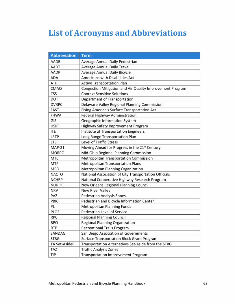
Metropolitan Pedestrian and Bicycle Planning Handbook 63
List of Acronyms and Abbreviations
Abbreviation Term AADB Average Annual Daily Pedestrian AADT Average Annual Daily Travel AADP Average Annual Daily Bicycle ADA Americans with Disabilities Act ATP Active Transportation Plan CMAQ Congestion Mitigation and Air Quality Improvement Program CSS Context Sensitive Solutions DOT Department of Transportation DVRPC Delaware Valley Regional Planning Commission FAST Fixing America's Surface Transportation Act FHWA Federal Highway Administration GIS Geographic Information System HSIP Highway Safety Improvement Program ITE Institute of Transportation Engineers LRTP Long Range Transportation Plan LTS Level of Traffic Stress MAP-21 Moving Ahead for Progress in the 21st Century MORPC Mid-Ohio Regional Planning Commission MTC Metropolitan Transportation Commission MTP Metropolitan Transportation Plans MPO Metropolitan Planning Organization NACTO National Association of City Transportation Officials NCHRP National Cooperative Highway Research Program NORPC New Orleans Regional Planning Council NRV New River Valley PAZ Pedestrian Analysis Zones PBIC Pedestrian and Bicycle Information Center PL Metropolitan Planning Funds PLOS Pedestrian Level of Service RPC Regional Planning Council RPO Regional Planning Organization RTP Recreational Trails Program SANDAG San Diego Association of Governments STBG Surface Transportation Block Grant Program TA Set-AsideP Transportation Alternatives Set-Aside from the STBG TAZ Traffic Analysis Zones TIP Transportation Improvement Program