2005 New Orleans Metropolitan Bicycle and Pedestrian Plan
249
New Orleans Metropolitan Bicycle and Pedestrian Plan Regional Planning Commission 2005 Jefferson, Orleans, Plaquemines, St. Bernard and St. Tammany Parishes September , 2006
-
Upload
pbriresearchlibrary -
Category
Documents
-
view
222 -
download
0
Transcript of 2005 New Orleans Metropolitan Bicycle and Pedestrian Plan

8/6/2019 2005 New Orleans Metropolitan Bicycle and Pedestrian Plan
http://slidepdf.com/reader/full/2005-new-orleans-metropolitan-bicycle-and-pedestrian-plan 1/249
New Orleans MetropolitanBicycle and Pedestrian Plan
Regional Planning Commission
2005
Jefferson, Orleans, Plaquemines, St. Bernard and St. Tammany Parishes
September, 2006

8/6/2019 2005 New Orleans Metropolitan Bicycle and Pedestrian Plan
http://slidepdf.com/reader/full/2005-new-orleans-metropolitan-bicycle-and-pedestrian-plan 2/249
2005New Orleans Metropolitan Bicycle and Pedestrian Plan
Prepared byRegional Planning Commission
1340 Poydras Street, Suite 2100New Orleans, Louisiana 70112
email: [email protected] site: www.norpc.org
FHWA Contrect No. PL-0011 (025)State Project No. 736-36-0025
The preparation of this document was nanced in part through grantsfrom the U.S. Department of Transportation, Federal Highway Administration
in accordance with the Transportation Equity Act for the 21st Century

8/6/2019 2005 New Orleans Metropolitan Bicycle and Pedestrian Plan
http://slidepdf.com/reader/full/2005-new-orleans-metropolitan-bicycle-and-pedestrian-plan 3/249
N e w O r l e a n s M e t r o p o l i t a n B i c y c l e a n d P e d e s t r i a n P l a n 2 0 0 5
Work on the 2005 New Orleans Metropolitan Bicycle and Pedestrian Plan was wrapped up in the months pre-ceding the de vastating e vents of August 29, 2005. This document does not a t empt to incorporate post-Katrinachanges to the en v ironment for b icycle and pedestrians. Howe ver, the volume of research reported here stillstands. O verall, policy recommendations and route identi cation continue to b e valid and applica b le. We shouldb uild upon the ndings in this document to direct speci c at ention where it is needed today.
The Regional Planning Commission wishes to acknowledge the importance of b icycle and pedestrian concernsin the a f ermath of Hurricane Katrina. Now, perhaps more than e ver in the history of New Orleans, we ha ve anopportunity to institutionali ze the framework for accommodating cyclists and pedestrians at the state and locallevels and to implement real projects and programs within e very jurisdiction in the metropolitan New Orleansarea. The Regional Planning Commission is commi t ed to this e ffort.
Karen Parsons, AICPBicycle and Pedestrian CoordinatorRegional Planning Commission

8/6/2019 2005 New Orleans Metropolitan Bicycle and Pedestrian Plan
http://slidepdf.com/reader/full/2005-new-orleans-metropolitan-bicycle-and-pedestrian-plan 4/249
Tab le of Contents
Chapter 10109Bicycle Networks
Chapter 11 161State Laws
Chapter 12 179Law Enforcement Practices
Chapter 13 189Education and Training
Chapter 14 201Safe Routes to School
Chapter 15 209Set ing Priorities
Chapter 16 229Benchmarking
Chapter 17 237Public and Private Sector Roles
Chapter 1 5Preface and Acknowledgements
Chapter 2 13Introduction
Chapter 3 19Existing Studies
Chapter 4 29Best Practices in Bicycle and PedestrianPlanning
Chapter 5 47Rider Classi cation
Chapter 6 53
Overview of Existing Conditions
Chapter 7 71Identifying Statistical Hot Spots
Chapter 8 93Transit Stop Pedestrian Survey
Chapter 9 99Bicycle Parking and Bike on Bus
Page Page
N e w O r l e a n s M e t r o p o l i t a n B i c
y c l e a n d P e d e s t r i a n
P l a n 2 0 0 5

8/6/2019 2005 New Orleans Metropolitan Bicycle and Pedestrian Plan
http://slidepdf.com/reader/full/2005-new-orleans-metropolitan-bicycle-and-pedestrian-plan 5/249
N e w O r l e a n s M e t r o p o l i t a n B
i c y c l e a n d P e d e s t r i a n P l a n 2 0 0 5
Figure 1 14Gulf South Comparison: Percentage ofMSA Households without Vehicles (2000)
Figure 2 26Alignment for the Bikeways in St. BernardParish
Figure 3 31TRB’s Guide for Reducing PedestrianCollisions
Figure 4 54Percentage of Pedestrian Crashes byParish
Figure 5 54Percentage of Bicycle Crashes by Parish
Figure 6 56 Jefferson Parish High Poverty BlockGroups
Figure 7 56Orleans Parish High Poverty BlockGroups
Figure 8 58Bicycle Crashes per Year
Figure 9 59Percentage of Bicycle Crashes by Severity
Figure 10 59Percent of Severity of Bicycle Crashes by Year
Figure 11 59Percentage of Bicycle Crashes by Month
List of Figures
Figure 12 60Percentage of Bicycle Crashes Per Day ofthe Week
Figure 13 60Number of Bicycle Crashes by Hour
Figure 14 60Age of Cyclists by Crash Frequency
Figure 15 61Cyclists Crashes: Juvenile vs Adult
Figure 16 61Percentage of Bicycle Crashes by Life-Stage Figure 17 61Percentage of Bicycle Crashes by LightingCondition
Figure 18 62Number of Pedestrian Crashes Per Year
Figure 19 62Percentage of Pedestrian Crashes bySeverity
Figure 20 62Percent of Severity of Pedestrian Crashes
Figure 21 63Percentage of Pedestrian Crashes byMonth
Figure 22 63Pedestrian Crashes by Day of the Week
Page Page

8/6/2019 2005 New Orleans Metropolitan Bicycle and Pedestrian Plan
http://slidepdf.com/reader/full/2005-new-orleans-metropolitan-bicycle-and-pedestrian-plan 6/249
Figure 23 63Number of Pedestrian Crashes by Hour
Figure 24 64Age of Pedestrian by Crash Frequency
Figure 25 64Percentage of Pedestrian Crashes by Age
Figure 26 64Percentage of Pedestrian Crashes by LifeStage
Figure 27 65Gender and Pedestrian Crashes
Figure 28 65Percentage of Pedestrian Crashes by LightingConditions
Figure 29 66French Quarter Street Pa t ern
Figure 30 67Wagon-Wheel Street Pro le
Figure 31 67Eastbank Je fferson Major ConnectivityBarriers
Figure 32 76Pedestrian Crashes 1999-2002 East BankCore
Figure 33 79Pedestrian Fuzzy Mode Tolerance QuarterMile
Figure 34 79Kmeans Pedestrian Cluster 5 Separation 3
Figure 35 80STAC Quarter Mile Cluster 5 Triangular
Figure 36 82Multiple Pedestrian Crash Locations1999-2000 (East Bank Core)
Figure 37 84Spatial and Temporal Analysis of Crime
Figure 38 85Statistically Signi cant Pedestrian Clusters,Orleans Parish
Figure 39 86Statistically Signi cant Bicycle Crash Clusters,Orleans and Je fferson Parishes
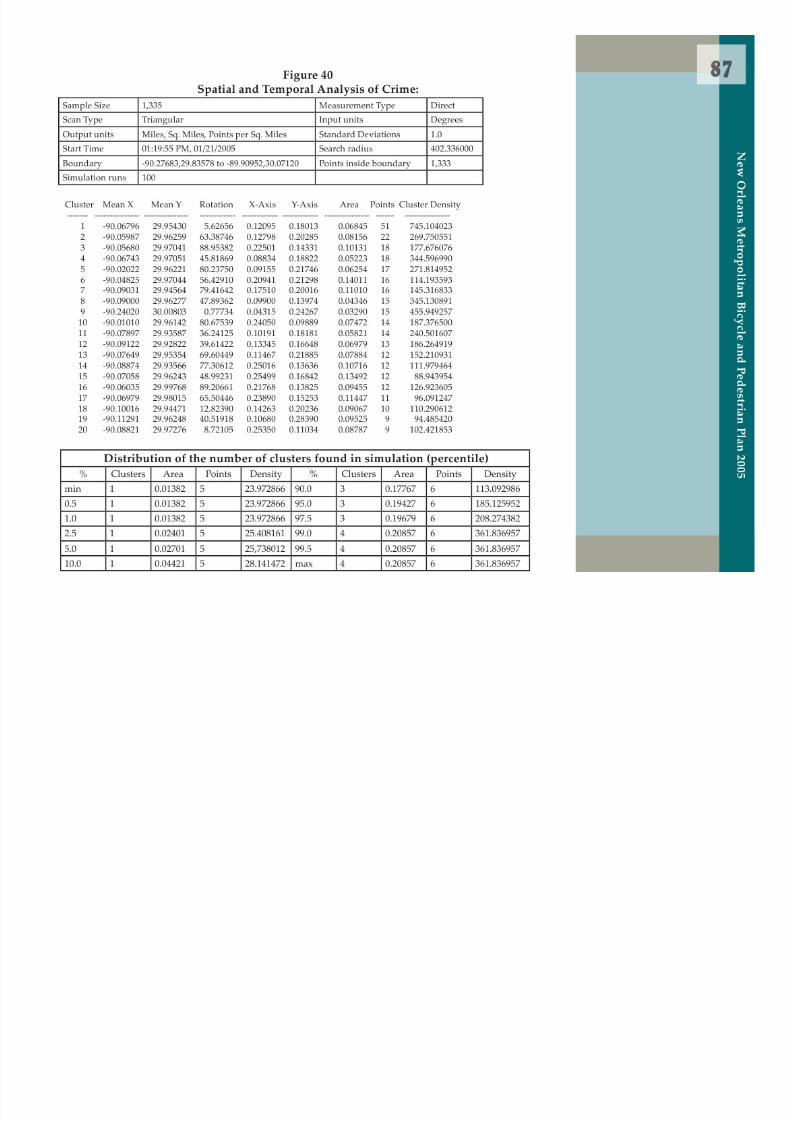
Figure 40 87Spatial and Temporal Analysis of Crime
Figure 41 89Multiple Bicycle Crash Locations 1999-2002(East Bank Core)
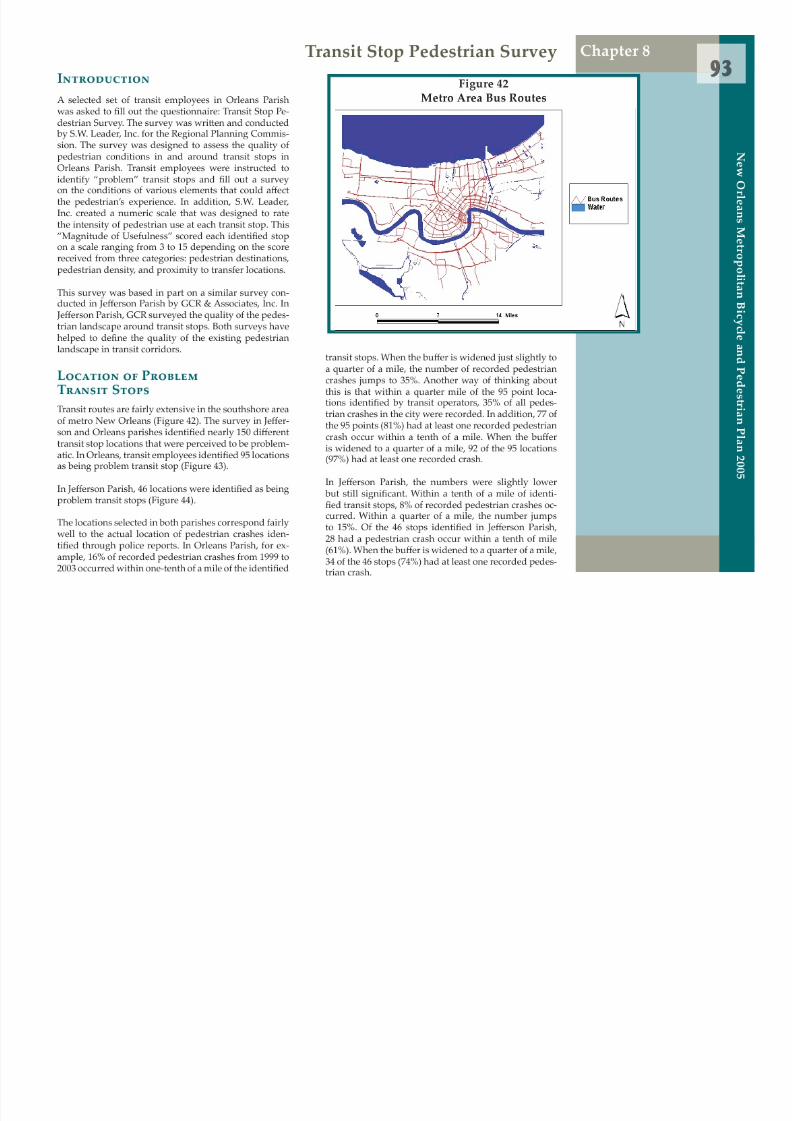
Figure 42 93Metro Area Bus Routes
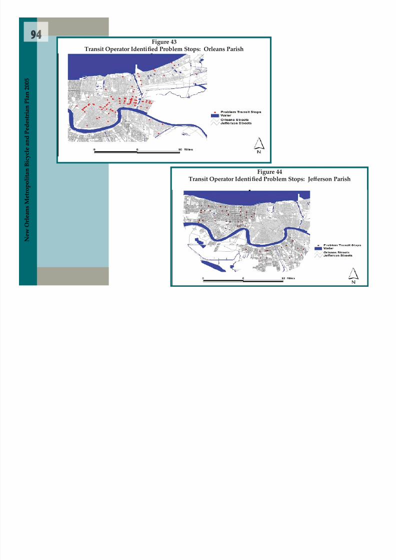
Figure 43 94Transit Operator Identi ed Problem Stops:Orleans Parish
Figure 44 94Transit Operator Identi ed Problem Stops: Jefferson Parish
PagePage
List of Figures
N e w
O r l e a n s
M e t r o p o l i t a n B
i c y c l e a n d
P e d e s t r i a n
P l a n 2 0 0 5

8/6/2019 2005 New Orleans Metropolitan Bicycle and Pedestrian Plan
http://slidepdf.com/reader/full/2005-new-orleans-metropolitan-bicycle-and-pedestrian-plan 7/249
Figure 45 103Downtown Bike Rack Plan, Phase 1
Figure 46 104Downtown Bike Rack Plan, Phase 2
Figure 47 105 Jefferson Transit Bike-on-Bus Users 2000-2004
Figure 48 110Central New Orleans Routes
Figure 49 111 Jefferson/St. Charles Corridor North
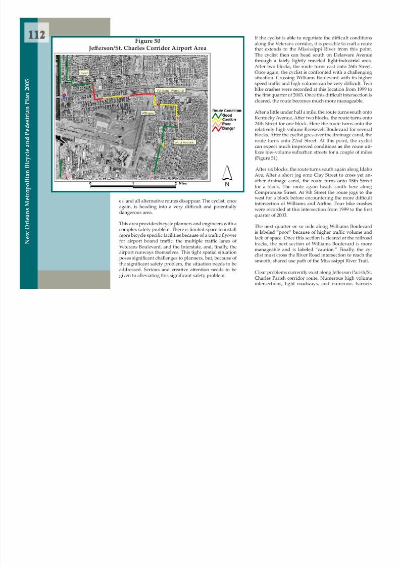
Figure 50 112 Jefferson/St. Charles Corridor Airport Area
Figure 51 113 Jefferson/St. Charles Corridor South
Figure 52 115Central Avenue Corridor North
Figure 53 117Central Avenue Corridor South
Figure 54 125 Jefferson/Orleans Corridor North
Figure 55 125 Jefferson/Orleans Corridor South
Figure 56 126Wisner Corridor North
Figure 57 129Wisner Corridor Mid-City
Figure 58 131Wisner Corridor South (Nashville Area)
Figure 59 133Esplanade Corridor
Figure 60 135St. Bernard Corridor North
Figure 61 137St. Bernard Corridor South
Figure 62 138Lakefront Corridor West
Figure 63 139Lakefront Corridor East
Figure 64 203Statistically Signi cant Children 6 andUnder
Figure 65 204High Poverty Block Groups and StatisticallySigni cant Child Pedestrian Crash Clusters
Figure 66 205Statistically Signi cant Youth PedestrianClusters, Orleans and Je fferson Parishes
Figure 67 205Statistically Signi cant Pedestrian CrashClusters and Crashes within 1 Mile ofProgram Schools
PagePage
List of Figures
N e w O r l e a n s M e t r o p o l i t a n B i c
y c l e a n d P e d e s t r i a n P l a n 2 0 0 5

8/6/2019 2005 New Orleans Metropolitan Bicycle and Pedestrian Plan
http://slidepdf.com/reader/full/2005-new-orleans-metropolitan-bicycle-and-pedestrian-plan 8/249
Table 1 53Louisiana Pedestrian Fatalities
Table 2 53Louisiana Bicycle Fatalities
Table 3 57Orleans Parish Pedestrian Crashes andPoverty
Table 4 57 Jefferson Parish Pedestrian Crashes andPoverty
Table 5 57Orleans Parish Bicycle Crashes and Poverty
Table 6 58 Jefferson Parish Bicycle Crashes and Poverty
Table 7 72Pedestrian Crashes Involving Youth under18, Orleans Parish
Table 8 73Proximity of Transit Routes to PedestrianCrashes, Orleans Parish
Table 9 74Proximity of Pedestrian Crashes to HousingDevelopments, Orleans Parish
Table 10 74Percentage of Pedestrian Crashes in theCBD and French Quarter
Table 11 81Top 15 Pedestrian Crash Locations
List of Ta b les
Table 12 85Statistically Signi cant Pedestrian CrashClusters, Orleans Parish
Table 13 86Statistically Signi cant Bicycle CrashClusters, Orleans and Je fferson Parishes
Table 14 88Top 15 Bicycle Crash Locations
Table 15 95Orleans Parish Transit Survey Responses
Table 16 95 Jefferson Parish Transit Survey Responses
Table 17 155Minimum Street Width Needed forRetro t ing with Bicycle Lane
Table 18 155Speed Limits
Table 19 157New Orleans Street Classi cations
Table 20 167Multi-Jurisdictional Comparison of Bicycleand Pedestrian Laws
Table 21 167Required Bicycle Equipment
Table 22 1802001 Bike Injuries by Race, Age and Gender
Page Page
N e w O r l e a n s M e t r o p o l i t a n B i c
y c l e a n d P e d e s t r i a n
P l a n 2 0 0 5

8/6/2019 2005 New Orleans Metropolitan Bicycle and Pedestrian Plan
http://slidepdf.com/reader/full/2005-new-orleans-metropolitan-bicycle-and-pedestrian-plan 9/249
Table 23 184Information Requests on Bicycle Enforcementto Local Police, Spring 2002
Table 24 214Programmed Transportation ImprovementProjects (1994-2004)
Table 25 225Bike / Pedestrian Policies
Table 26 231Safety, 2002
Table 27 231Safe Routes to School Programs, 2005
Table 28 232Modal Share, 2000
Table 29 232Miles of Existing On-Street Bicycle Lanes,2005
Table 30 232Miles of Existing O ff-Street Shared-Use Paths,2005
Table 31 233Facilities, 2003
Table 32 233Facilities, 2005
Table 33 233
Funding, 1994-2003
Table 34 233Funding thru 2004
Page
Table 35 234Organizational Adopted Bike/PedestrianPlan
Page
List of Ta b les
N e w
O r l e a n s
M e t r o p o l i t a n B
i c y c l e a n d
P e d e s t r i a n
P l a n 2 0 0 5

8/6/2019 2005 New Orleans Metropolitan Bicycle and Pedestrian Plan
http://slidepdf.com/reader/full/2005-new-orleans-metropolitan-bicycle-and-pedestrian-plan 10/249

8/6/2019 2005 New Orleans Metropolitan Bicycle and Pedestrian Plan
http://slidepdf.com/reader/full/2005-new-orleans-metropolitan-bicycle-and-pedestrian-plan 11/249
Preface and Acknowledgements

8/6/2019 2005 New Orleans Metropolitan Bicycle and Pedestrian Plan
http://slidepdf.com/reader/full/2005-new-orleans-metropolitan-bicycle-and-pedestrian-plan 12/249

8/6/2019 2005 New Orleans Metropolitan Bicycle and Pedestrian Plan
http://slidepdf.com/reader/full/2005-new-orleans-metropolitan-bicycle-and-pedestrian-plan 13/249
8/6/2019 2005 New Orleans Metropolitan Bicycle and Pedestrian Plan
http://slidepdf.com/reader/full/2005-new-orleans-metropolitan-bicycle-and-pedestrian-plan 14/249

8/6/2019 2005 New Orleans Metropolitan Bicycle and Pedestrian Plan
http://slidepdf.com/reader/full/2005-new-orleans-metropolitan-bicycle-and-pedestrian-plan 15/249

8/6/2019 2005 New Orleans Metropolitan Bicycle and Pedestrian Plan
http://slidepdf.com/reader/full/2005-new-orleans-metropolitan-bicycle-and-pedestrian-plan 16/249
Special thanks go to Brian Bowman, New Orleans CityPlanning Commission, for his work standardizing thewrite-ups done by advocates on the routes of regionalsigni cance when working for the Regional PlanningCommission. Brian subsequently used his knowledgeand experience to accomplish a phased bicycle routemap for the city of New Orleans’ Transportation Elementof the Master Plan. For that, we are especially apprecia-tive. Billy Fields, PhD also contributed by nalizing andmapping this chapter.
Many thanks to Audrey Warren for her work to estab-
lish and pilot the rst Safe Routes to School program inthe city of New Orleans and the state of Louisiana. Au-drey contributed to the section reporting on Safe Routesto School programmatic advancements.
Finally, the sta ff of the Regional Planning Commissionwould like to thank the elected and citizen members ofthe Commission for allowing this study to proceed un-hindered. Only fearless and resolute leadership looksdeeply at their regional shortcomings so appropriateand equitable steps can be taken to improve the condi-tions for its citizens.
Karen Parsons, AICPRegional Bicycle and Pedestrian Coordinator
N e w O r l e a n s M e t r o p o l i t a n B i c y c l e a n d P e d e s t r i a n P l a n 2 0 0 5

8/6/2019 2005 New Orleans Metropolitan Bicycle and Pedestrian Plan
http://slidepdf.com/reader/full/2005-new-orleans-metropolitan-bicycle-and-pedestrian-plan 17/249

8/6/2019 2005 New Orleans Metropolitan Bicycle and Pedestrian Plan
http://slidepdf.com/reader/full/2005-new-orleans-metropolitan-bicycle-and-pedestrian-plan 18/249
Introduction

8/6/2019 2005 New Orleans Metropolitan Bicycle and Pedestrian Plan
http://slidepdf.com/reader/full/2005-new-orleans-metropolitan-bicycle-and-pedestrian-plan 19/249
8/6/2019 2005 New Orleans Metropolitan Bicycle and Pedestrian Plan
http://slidepdf.com/reader/full/2005-new-orleans-metropolitan-bicycle-and-pedestrian-plan 20/249

8/6/2019 2005 New Orleans Metropolitan Bicycle and Pedestrian Plan
http://slidepdf.com/reader/full/2005-new-orleans-metropolitan-bicycle-and-pedestrian-plan 21/249
8/6/2019 2005 New Orleans Metropolitan Bicycle and Pedestrian Plan
http://slidepdf.com/reader/full/2005-new-orleans-metropolitan-bicycle-and-pedestrian-plan 22/249
5
N e w O r l e a n s M e t r o p o l i t a n B i c
y c l e a n d P e d e s t r i a n P l a n 2 0 0 5
work for addressing how policy e fforts are working toimprove bicycling and walking.
This Master Plan provides a clear overall direction forpolicy decisions a ffecting bicycling and walking. It doesnot, however, lay out a fully formulated set of speci cpolicies for achieving these goals. This Master Plan has
been the rst full- edged e ffort to address bicycling andwalking in the New Orleans region. As such, the rsttask in the process has been to build awareness and con-sensus about the importance of bicycling and walkingto the region. Translating this awareness into a system-atic set of policy actions is the next important step inthe transformation process. While the region has seen anumber of good ad-hoc projects, these e fforts have tra-ditionally not been tied to an overarching policy docu-ment se t ing out speci c goals, policies, objectives, andaction items. This should be the next step in working toimprove bicycling and walking conditions in our region.This important step will require a concerted e ffort to co-ordinate regional policies for bicycling and walking.
The Regional Planning Commission is commi t ed toexpanding the constructive framework set out in thisMaster Plan to help improve bicycling and walking con-ditions in the New Orleans region. This Master Plan has
begun to build a strong base of commi t ed local officialswho are working to improve conditions in our area. TheRPC will work to keep this strong momentum going tohelp improve bicycling and walking conditions in theregion.

8/6/2019 2005 New Orleans Metropolitan Bicycle and Pedestrian Plan
http://slidepdf.com/reader/full/2005-new-orleans-metropolitan-bicycle-and-pedestrian-plan 23/249

8/6/2019 2005 New Orleans Metropolitan Bicycle and Pedestrian Plan
http://slidepdf.com/reader/full/2005-new-orleans-metropolitan-bicycle-and-pedestrian-plan 24/249
Existing Studies

8/6/2019 2005 New Orleans Metropolitan Bicycle and Pedestrian Plan
http://slidepdf.com/reader/full/2005-new-orleans-metropolitan-bicycle-and-pedestrian-plan 25/249

8/6/2019 2005 New Orleans Metropolitan Bicycle and Pedestrian Plan
http://slidepdf.com/reader/full/2005-new-orleans-metropolitan-bicycle-and-pedestrian-plan 26/249

8/6/2019 2005 New Orleans Metropolitan Bicycle and Pedestrian Plan
http://slidepdf.com/reader/full/2005-new-orleans-metropolitan-bicycle-and-pedestrian-plan 27/249

8/6/2019 2005 New Orleans Metropolitan Bicycle and Pedestrian Plan
http://slidepdf.com/reader/full/2005-new-orleans-metropolitan-bicycle-and-pedestrian-plan 28/249
8/6/2019 2005 New Orleans Metropolitan Bicycle and Pedestrian Plan
http://slidepdf.com/reader/full/2005-new-orleans-metropolitan-bicycle-and-pedestrian-plan 29/249

8/6/2019 2005 New Orleans Metropolitan Bicycle and Pedestrian Plan
http://slidepdf.com/reader/full/2005-new-orleans-metropolitan-bicycle-and-pedestrian-plan 30/249

8/6/2019 2005 New Orleans Metropolitan Bicycle and Pedestrian Plan
http://slidepdf.com/reader/full/2005-new-orleans-metropolitan-bicycle-and-pedestrian-plan 31/249

8/6/2019 2005 New Orleans Metropolitan Bicycle and Pedestrian Plan
http://slidepdf.com/reader/full/2005-new-orleans-metropolitan-bicycle-and-pedestrian-plan 32/249

8/6/2019 2005 New Orleans Metropolitan Bicycle and Pedestrian Plan
http://slidepdf.com/reader/full/2005-new-orleans-metropolitan-bicycle-and-pedestrian-plan 33/249
N e w
O r l e a n s
M e t r o p o l i t a n B
i c y c l e a n d
P e d e s t r i a n
P l a n 2 0 0 5
Figure 2Segment Alignment
1 Orleans/St. Bernard Parish line to Center Street Center Street to LA 47 (Paris Road)
2 LA 47 to Lake Borgne Levee Administration Building
3 Lake Borgne Levee District Administration building
to Montenlongo Lane Montelongo Lane to St. Bernard Parish/Plaquemines
Parish line
2 Main north-south route from Oak Harbor to
the Interstate (6.4 miles)
Interim links between Pontchartrain Traceand Tammany Trace (about 4 miles inlength)
Neighborhood routes (5 routes about 25miles in length).
Other general topics covered included types of bike-ways and bike path ratings based on safety and driverskill. (Major bicycle routes are classi ed as “A” whileneighborhood routes are designated “C”. When “C”routes are linked with “A” they are considered upgrad-ed to “B”).
Proposed Bicycle Plan forSt. Bernard (2001)
The study focused on St. Bernard Parish and proposedthat a 10-mile stretch of river levee in St. Bernard Parish
be used for a bike path that would join the levees in Or-leans and Je fferson parishes thus connecting the parishwith other parts of the New Orleans metro area. Thisstudy proposed the following alignment for the bike-ways in St. Bernard Parish:
Other issues discussed in the study included:
(a) Entities that can play a role in the St. Bernard
Parish bike path development:American Heritage Rivers Initiative (AHRI)
Mississippi River Trail (MRT)
(b) Legal issues related to use of levees and re-strictions imposed by private landowners
(c) Operation and maintenance costs & responsi- bilities
(d) Funding OptionsTEA-21, reserve funds, revenue bonds,lease purchase, special assessments, stateand ederal grants
(e) Phasing
Proposed phasing priority was segment 2, 3and nally 1.

8/6/2019 2005 New Orleans Metropolitan Bicycle and Pedestrian Plan
http://slidepdf.com/reader/full/2005-new-orleans-metropolitan-bicycle-and-pedestrian-plan 34/249
Best Practices in Bicycle and Pedestrial Planning

8/6/2019 2005 New Orleans Metropolitan Bicycle and Pedestrian Plan
http://slidepdf.com/reader/full/2005-new-orleans-metropolitan-bicycle-and-pedestrian-plan 35/249

8/6/2019 2005 New Orleans Metropolitan Bicycle and Pedestrian Plan
http://slidepdf.com/reader/full/2005-new-orleans-metropolitan-bicycle-and-pedestrian-plan 36/249

8/6/2019 2005 New Orleans Metropolitan Bicycle and Pedestrian Plan
http://slidepdf.com/reader/full/2005-new-orleans-metropolitan-bicycle-and-pedestrian-plan 37/249

8/6/2019 2005 New Orleans Metropolitan Bicycle and Pedestrian Plan
http://slidepdf.com/reader/full/2005-new-orleans-metropolitan-bicycle-and-pedestrian-plan 38/249

8/6/2019 2005 New Orleans Metropolitan Bicycle and Pedestrian Plan
http://slidepdf.com/reader/full/2005-new-orleans-metropolitan-bicycle-and-pedestrian-plan 39/249
8/6/2019 2005 New Orleans Metropolitan Bicycle and Pedestrian Plan
http://slidepdf.com/reader/full/2005-new-orleans-metropolitan-bicycle-and-pedestrian-plan 40/249

8/6/2019 2005 New Orleans Metropolitan Bicycle and Pedestrian Plan
http://slidepdf.com/reader/full/2005-new-orleans-metropolitan-bicycle-and-pedestrian-plan 41/249

8/6/2019 2005 New Orleans Metropolitan Bicycle and Pedestrian Plan
http://slidepdf.com/reader/full/2005-new-orleans-metropolitan-bicycle-and-pedestrian-plan 42/249

8/6/2019 2005 New Orleans Metropolitan Bicycle and Pedestrian Plan
http://slidepdf.com/reader/full/2005-new-orleans-metropolitan-bicycle-and-pedestrian-plan 43/249

8/6/2019 2005 New Orleans Metropolitan Bicycle and Pedestrian Plan
http://slidepdf.com/reader/full/2005-new-orleans-metropolitan-bicycle-and-pedestrian-plan 44/249

8/6/2019 2005 New Orleans Metropolitan Bicycle and Pedestrian Plan
http://slidepdf.com/reader/full/2005-new-orleans-metropolitan-bicycle-and-pedestrian-plan 45/249

8/6/2019 2005 New Orleans Metropolitan Bicycle and Pedestrian Plan
http://slidepdf.com/reader/full/2005-new-orleans-metropolitan-bicycle-and-pedestrian-plan 46/249

8/6/2019 2005 New Orleans Metropolitan Bicycle and Pedestrian Plan
http://slidepdf.com/reader/full/2005-new-orleans-metropolitan-bicycle-and-pedestrian-plan 47/249

8/6/2019 2005 New Orleans Metropolitan Bicycle and Pedestrian Plan
http://slidepdf.com/reader/full/2005-new-orleans-metropolitan-bicycle-and-pedestrian-plan 48/249

8/6/2019 2005 New Orleans Metropolitan Bicycle and Pedestrian Plan
http://slidepdf.com/reader/full/2005-new-orleans-metropolitan-bicycle-and-pedestrian-plan 49/249
8/6/2019 2005 New Orleans Metropolitan Bicycle and Pedestrian Plan
http://slidepdf.com/reader/full/2005-new-orleans-metropolitan-bicycle-and-pedestrian-plan 50/249

8/6/2019 2005 New Orleans Metropolitan Bicycle and Pedestrian Plan
http://slidepdf.com/reader/full/2005-new-orleans-metropolitan-bicycle-and-pedestrian-plan 51/249

8/6/2019 2005 New Orleans Metropolitan Bicycle and Pedestrian Plan
http://slidepdf.com/reader/full/2005-new-orleans-metropolitan-bicycle-and-pedestrian-plan 52/249
Rider Classi cation

8/6/2019 2005 New Orleans Metropolitan Bicycle and Pedestrian Plan
http://slidepdf.com/reader/full/2005-new-orleans-metropolitan-bicycle-and-pedestrian-plan 53/249
8/6/2019 2005 New Orleans Metropolitan Bicycle and Pedestrian Plan
http://slidepdf.com/reader/full/2005-new-orleans-metropolitan-bicycle-and-pedestrian-plan 54/249

8/6/2019 2005 New Orleans Metropolitan Bicycle and Pedestrian Plan
http://slidepdf.com/reader/full/2005-new-orleans-metropolitan-bicycle-and-pedestrian-plan 55/249

8/6/2019 2005 New Orleans Metropolitan Bicycle and Pedestrian Plan
http://slidepdf.com/reader/full/2005-new-orleans-metropolitan-bicycle-and-pedestrian-plan 56/249

8/6/2019 2005 New Orleans Metropolitan Bicycle and Pedestrian Plan
http://slidepdf.com/reader/full/2005-new-orleans-metropolitan-bicycle-and-pedestrian-plan 57/249

8/6/2019 2005 New Orleans Metropolitan Bicycle and Pedestrian Plan
http://slidepdf.com/reader/full/2005-new-orleans-metropolitan-bicycle-and-pedestrian-plan 58/249
Overv iew of E xisting Conditions

8/6/2019 2005 New Orleans Metropolitan Bicycle and Pedestrian Plan
http://slidepdf.com/reader/full/2005-new-orleans-metropolitan-bicycle-and-pedestrian-plan 59/249

8/6/2019 2005 New Orleans Metropolitan Bicycle and Pedestrian Plan
http://slidepdf.com/reader/full/2005-new-orleans-metropolitan-bicycle-and-pedestrian-plan 60/249
8/6/2019 2005 New Orleans Metropolitan Bicycle and Pedestrian Plan
http://slidepdf.com/reader/full/2005-new-orleans-metropolitan-bicycle-and-pedestrian-plan 61/249

8/6/2019 2005 New Orleans Metropolitan Bicycle and Pedestrian Plan
http://slidepdf.com/reader/full/2005-new-orleans-metropolitan-bicycle-and-pedestrian-plan 62/249
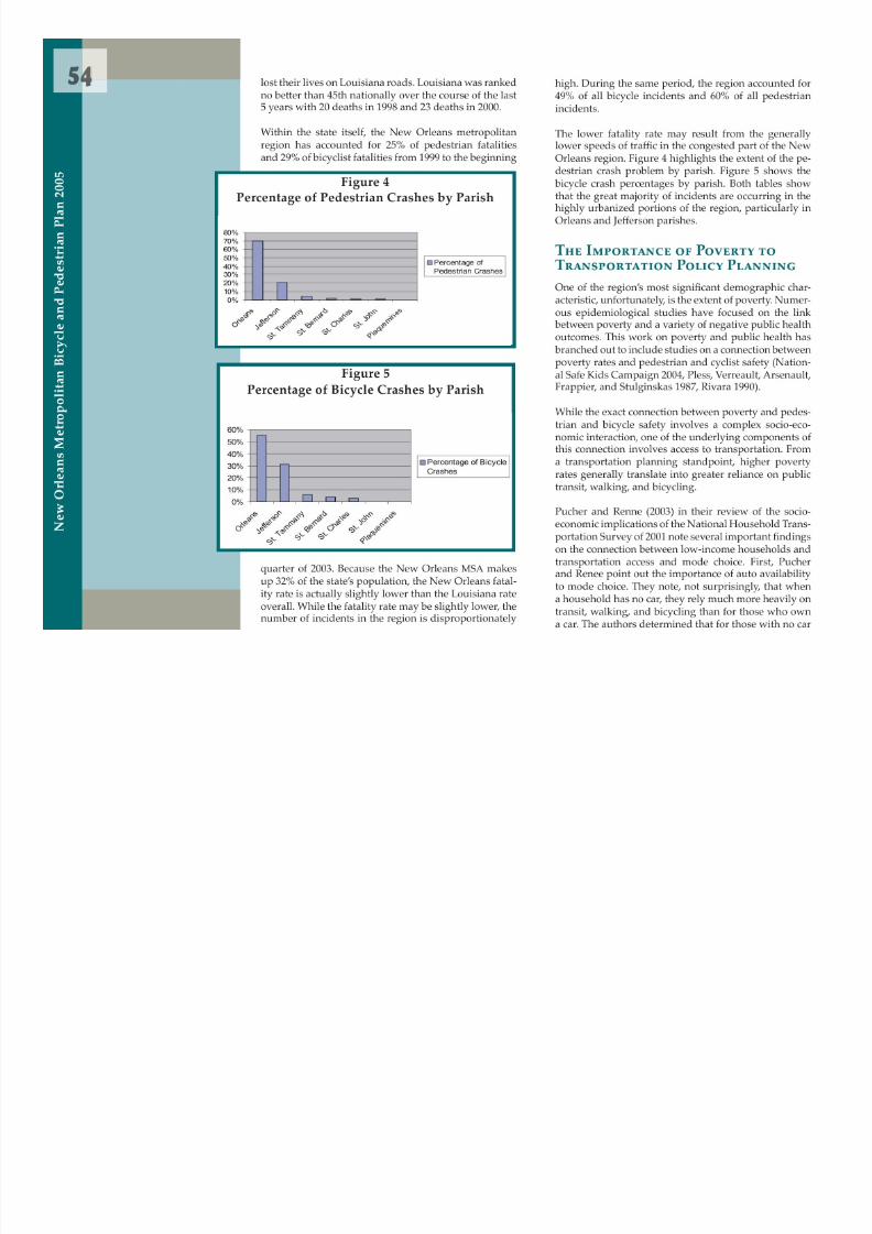
A closer look at the pa t ern of crashes in the New Or-leans metropolitan region shows more clearly how the
5 Figure 6Jeff erson Parish High Po verty Block Groups

8/6/2019 2005 New Orleans Metropolitan Bicycle and Pedestrian Plan
http://slidepdf.com/reader/full/2005-new-orleans-metropolitan-bicycle-and-pedestrian-plan 63/249
leans metropolitan region shows more clearly how thenegative connection between poverty and pedestrianand cyclist safety functions. Tables 3 and 4 present thepercentage of pedestrian crashes within and adjacentto high poverty block groups in Orleans and Je ffersonparishes.
These data show that within high poverty block groupsthere is an over representation of pedestrian crashescompared to the population of these areas. For exam-ple, in 2002, 42% of pedestrian crashes occurred in highpoverty block groups in Orleans and 10% of these same
type of crashes occurred in Je fferson high poverty ar-eas. (Remember that Orleans high poverty block groupscontained 28% of the population and Je fferson’s highpoverty block groups contained 3% of the population).
When walking trips adjacent to the high poverty blockgroups are taken into account, the extent of the problemis further accentuated. It is important to include tripsnear or adjacent to high poverty areas because manystores and transit stops lie just beyond the edges of theseareas. When ¼ mile and ½ mile delineations are used toanalyze these data, the percentage of pedestrian crashesclimbs dramatically. While it is di fficult to untangle allof the demographic and spatial interactions that arehelping to produce these results, the high percentage ofpedestrian incidents occurring in and adjacent to highpoverty areas should be seriously examined by thoseinvolved with safety and transportation policy.
The analysis of bicycle data in relation to poverty pro-duced similar results to the pedestrian analysis. Thedisparity between Orleans and Je fferson, however, waseven more pronounced. Within a ½ mile of high pov-erty block groups in Orleans, up to 91% of all bicyclecrashes were recorded. In Je fferson, however, the per-centage only ranged as high as 28% for recorded bicyclecrashes within ½ a mile of high poverty block groups.Tables 5 and 6 show these results.
When walking trips adjacent to the high poverty blockgroups are taken into account, the extent of the problem
N e w
O r l e a n s M e t r o p o l i t a n
B i c y c l e a n d
P e d e s t r i a n P l a n 2 0 0 5
Figure 7
Orleans Parish High Po verty Block Groups
Je erson Parish High Po verty Block Groups

8/6/2019 2005 New Orleans Metropolitan Bicycle and Pedestrian Plan
http://slidepdf.com/reader/full/2005-new-orleans-metropolitan-bicycle-and-pedestrian-plan 64/249

8/6/2019 2005 New Orleans Metropolitan Bicycle and Pedestrian Plan
http://slidepdf.com/reader/full/2005-new-orleans-metropolitan-bicycle-and-pedestrian-plan 65/249
Summary Statistics of Regional Bicycle and Pedestrian Crashes
9Figure 9
Percentage of Bicycle Crashes b y Se verity

8/6/2019 2005 New Orleans Metropolitan Bicycle and Pedestrian Plan
http://slidepdf.com/reader/full/2005-new-orleans-metropolitan-bicycle-and-pedestrian-plan 66/249
Bicycle and Pedestrian Crashes
Regional data for the New Orleans metropolitan areahave been examined for both bicycle and pedestriancrashes. The data have been examined to determinehow many people are involved in crashes, the severityof injuries sustained in those crashes, when these inci-dents are occurring, and who is involved in the colli-sions. The analysis in this chapter is descriptive, but ithelps to shed light on some interesting pa t erns. The
bicycle data is examined rst.
The number of bicycle crashes in the New Orleans met-ropolitan area was examined for the 4 years of data from1999 to 2002 (Figure 8). The highest number of crasheswas recorded in 1999 (over 500). A f er a sharp drop tothe mid-300s in 2001, the number shot up again to over400 in 2002. The direction of the trend in these numbersis difficult to determine with the up and down yearlytotals.
In order to make these data more meaningful, it would be useful to a t ach a rate of crashes per number of bi-cyclists in order to determine relative risk. This tech-nique helps to show whether yearly crash total declinesor increases are due to increases or decreases in rider-ship numbers. Future data collection e fforts should begeared towards creating a baseline “exposure estimate”(City of Toronto 2003) of current riders to establish thismeaningful rate. In addition, the analysis of these datashould be undertaken yearly in order to determine boththe direction of the trend in crashes as well as the extentof success in safety programs.
The severity of injuries sustained by cyclists is anotherimportant component of the dataset. Figure 9 shows thepercentage of crashes for the di fferent severity typeslisted in the crash reports. Figure 10 shows the percent-ages for each of these crash types by year. While the ma-
jority of cyclists sustained either minimal or no injury,
the moderate, severe, and fatal categories still accountfor 30 to 40% of all crashes. The trend in these crashesappears to be fairly consistent from year to year.
N e w O r l e a n s M e t r o p o l i t a n B i c y c l e a n d P e d e s t r i a n P l a n 2 0 0 5
g y y y
Figure 10Percent of Se verity of Bicycle Crashes By Year
Figure 11
Percentage of Bicycle Crashes b y Month
Another way to look at these data is to compare month-to-month crash data. Figure 11 shows that the number ofbic cle crashes peaks in J l ith o er 10% and drops to
6Figure 12
Percentage of Bicycle Crashes

8/6/2019 2005 New Orleans Metropolitan Bicycle and Pedestrian Plan
http://slidepdf.com/reader/full/2005-new-orleans-metropolitan-bicycle-and-pedestrian-plan 67/249
Figure 13Num b er of Bicycle Crashes b y Hour
bicycle crashes peaks in July with over 10% and drops tounder 6% in November. This pa t ern of a high number of
summer crashes probably has to do with increased ridernumbers during this period.
Figure 12 shows the distribution of crashes by day of theweek. Aside from a small spike on Fridays, the data arefairly evenly distributed.
The crashes per hour of the day represented in Figure 13show a spike in the a f ernoon hours between 4 and 7 PM.Again, this is probably due to the increased numbersof riders and increased congestion during this period.Detailed data on ridership pa t erns and volume would
be extremely useful here to help create a more focusedanalysis of these data.
The age of cyclists involved in crashes (Figure 14) showstwo peaks. The rst and largest peak is for 13 year olds.The second peak is for 41 year olds. According to o fficialsat Charity Hospital, the average age of emergency roomadmissions for bicycling crashes is 43. This second peakcould relate to the higher number of older residents thatdo not own a car and rely on the bicycle to move aroundthe community.
The age distribution of the New Orleans crashes is verydifferent from the pa t ern seen in some other areas. Ina comprehensive study of Toronto cyclists, the peak inincidents occurred for mid- to late-twenty year olds.
Because of the higher levels of bicycle commuting andridership in this age group, they were more likely to beinvolved in crashes. The relatively low number of mid-twenty year olds seen the New Orleans metropolitan da-taset could be seen as an indication of a relatively lownumber of commuting and recreational cyclists in thisage group. Again, a detailed analysis of the rate of in-
jury would help to be t er understand the implicationsof these data.
Another way to slice these data is to look at the per-centage of adults versus juveniles involved in bicycle
N e w
O r l e a n s M e t r o p o l i t a n
B i c y c l e a n d
P e d e s t r i a n P l a n 2 0 0 5
Percentage of Bicycle CrashesPer Day of the Week
Figure 14Age of Cyclists b y Crash Frequency

8/6/2019 2005 New Orleans Metropolitan Bicycle and Pedestrian Plan
http://slidepdf.com/reader/full/2005-new-orleans-metropolitan-bicycle-and-pedestrian-plan 68/249
2000, pedestrian crashes have averaged around 650 to750 crashes per year.
6Figure 18
Num b er of Pedestrian Crashes Per Year

8/6/2019 2005 New Orleans Metropolitan Bicycle and Pedestrian Plan
http://slidepdf.com/reader/full/2005-new-orleans-metropolitan-bicycle-and-pedestrian-plan 69/249
An examination of the severity in pedestrian crashes
(Figure 19) shows a slightly lower percentage of crash-es reported as “no injury” and a higher percentage ofmoderate and severe injuries compared to the bicyclingdata. The di fference in the basic dynamics of the twotypes of crashes could result in these di fferences withpedestrians taking a much more direct impact from thecollisions. Figure 20 shows the fairly stable pa t ern ofthe severity of crashes over the study period.
The percentage of pedestrian crashes by month (Figure21) shows an interesting peak of crashes in March andApril. The good weather of these months may result inhigher pedestrian numbers. Because the rate of pedes-trian crashes is unavailable, it is di fficult to determineexactly what to make of these di fferences. Just as in the
bicycling analysis, a study to determine the rate of pe-destrian crashes by population would provide muchneeded insight into the dynamics of pedestrian crashes.
Figure 22 shows the percentage of pedestrian crashes byday of the week. Just as in the bicycling data, there is asmall increase in crashes on Friday.
Figure 23 shows the number of pedestrian crashes byhour. Again, just as in the bicycling data, there is an af-ternoon peak between 3 and 7 P.M. with a small morn-ing peak.
While much of the pedestrian and bicycling crash dataappears to be a mirror image of one another, the age datashows some signi cant di fferences. The age of pedes-trian crashes shows two juvenile peaks at around ages 6and 13 (Figure 24). The highest peak is for the youngerset of children. This large peak in the pedestrian data ismuch more pronounced than in the bicycling data.
Because younger children are still developing the cogni-tive skills necessary to safely move about their neigh-
borhoods, this younger age group is more likely to beinvolved in crashes. Rivara (1990) in his study of child
N e w
O r l e a n s
M e t r o p o l i t a n
B i c y c l e a n d
P e d e s t r i a n P l a n 2 0 0 5
Num b er of Pedestrian Crashes Per Year
Figure 19Percentage of Pedestrian Crashes b y Se verity
Figure 20
Percent of Sev
erity of Pedestrian Crashes
pedestrian injuries in the United States found that thisage group was particularly vulnerable. He says that,“The early school-age child appears to represent a ‘win-
3Figure 21
Percentage of Pedestrian Crashes b y Month

8/6/2019 2005 New Orleans Metropolitan Bicycle and Pedestrian Plan
http://slidepdf.com/reader/full/2005-new-orleans-metropolitan-bicycle-and-pedestrian-plan 70/249
dow of vulnerability’ in which expectations and de-
mands of the child as a pedestrian exceed the skills heor she can bring to bear on the crossing task” (p. 693).This tendency of adults to overestimate the actual cog-nitive development of their children might be addressedthrough a focused safety education program aimed ateducating adults.
While the largest spikes in pedestrian crashes appear inthe juvenile age category, the largest percentage of pe-destrian crashes occur with adults (Figure 25). This pat-tern again matches the one established in the bicyclingcrash analysis.
Figure 26 shows the life stages for pedestrians involvedin crashes. The pa t ern is nearly identical to the bicyclingdata except for a reversal in the incidence of crashes be-tween the child and youth categories. Rivara’s analysis(1990) examined earlier helps to explain this di fference.
One eld of data that was available in the pedestriandata that was not available in the bicycling data is thegender of the pedestrian involved in the crash (Figure27). Males accounted for about 60% of all those involvedin crashes while females accounted for approximately40%.
The nal histogram displays the percentage of pedes-trian crashes by lighting condition (Figure 28). Just as inthe bicycling analysis, the majority of crashes occurredin daylight hours. Again, this could be caused by thehigher number of pedestrians active during this period.
Implications of Summary Statistics
The analysis of pedestrian and bicycling crashes pre-sented thus far is intended to provide a descriptive por-
trait of how many people are involved in crashes, the se-verity of injuries sustained in those crashes, when theseincidents are occurring, and who is involved in the colli-
N e w O r l e a n s M e t r o p o l i t a n B i c y c l e a n d P e d e s t r i a n P l a n 2 0 0 5
Figure 22Pedestrian Crashes b y Day of the Week
Figure 23Num b er of Pedestrian Crashes b y Hour

8/6/2019 2005 New Orleans Metropolitan Bicycle and Pedestrian Plan
http://slidepdf.com/reader/full/2005-new-orleans-metropolitan-bicycle-and-pedestrian-plan 71/249

8/6/2019 2005 New Orleans Metropolitan Bicycle and Pedestrian Plan
http://slidepdf.com/reader/full/2005-new-orleans-metropolitan-bicycle-and-pedestrian-plan 72/249

8/6/2019 2005 New Orleans Metropolitan Bicycle and Pedestrian Plan
http://slidepdf.com/reader/full/2005-new-orleans-metropolitan-bicycle-and-pedestrian-plan 73/249
7Figure 30
Wagon-Wheel Street Pro lelarge-scale movement of the automobile. This suburbanpa t ern helps to create enclaves of low-intensity traf- c linked to high-intensity commercial areas via large,single purpose automotive tra ffic arteries This system

8/6/2019 2005 New Orleans Metropolitan Bicycle and Pedestrian Plan
http://slidepdf.com/reader/full/2005-new-orleans-metropolitan-bicycle-and-pedestrian-plan 74/249
single purpose automotive tra ffic arteries. This system
creates signi
cant connectivity problems for pedestriansand bicyclists that are characteristic of other suburbanareas around the country.
While this basic pa t ern has been repeated in countlesscommunities around the country, Je fferson Parish’s land-scape constraints have helped to create several uniquechallenges. The East Bank of Je fferson is divided by a se-ries of large-scale transportation corridors. The east-westdividers include Je fferson Highway, Earhart Express-way, Airline Drive, West Metairie, West Napoleon, Inter-state-10, Veterans Boulevard, and West Esplanade. Thesemajor, multi-lane arteries create signi cant impedimentsto movement of bicycles and pedestrians in the parish.The situation is compounded by the relative scarcity ofat-grade, north-south routes that breach the Interstate.The older urbanized portion of the parish from Bon-nabel Boulevard to the parish line has several at-graderoads that create decent pedestrian and bicycling access
to the lake side of the parish. The newer suburbanizedportion of the parish moving towards Kenner, howev-er, is connected to the lake side by elevated roadwaysat Causeway, Cleary, Clearview, and David Drive, withonly the heavily tra fficked Williams and Loyola cross-ings at grade. Only Transcontinental provides a decentconnection for pedestrian and cyclists on this side of theparish. The numerous drainage canals and railroads thatcross the area further accentuate the connectivity prob-lems of the parish (Figure 31). Je fferson Parish’s pa t ernof pedestrian and bicyclist crashes shows the impact ofthese connectivity barriers. Understanding the speci cimplications of these connectivity problems is the taskof Chapter 7.
N e w O r l e a n s M e t r o p o l i t a n B i c y c l e a n d P e d e s t r i a n P l a n 2 0 0 5
Figure 31East b ank Je ff erson Major Connecti v ity Barriers
6 Works Cited
City of Toronto. 2003. City of Toronto Bicycle/Motor-Vehicle Collision Study Works and Emergency Service
8/6/2019 2005 New Orleans Metropolitan Bicycle and Pedestrian Plan
http://slidepdf.com/reader/full/2005-new-orleans-metropolitan-bicycle-and-pedestrian-plan 75/249
Vehicle Collision Study. Works and Emergency Service
Department.Fields, Willard. 2004. Cite Dissertation
Jargowsky, Paul. 1997. Poverty and Place: Ghe t os, Bar-rios, and the American City. New York: Russell SageFoundation.
Lewis, Peirce. 2003. The Making of an Urban Land-scape
National Safe Kids Campaign. 2004. Injury Facts: Chil-dren at Risk. Website. www.sa ids.org.
Pless, I. Bary and Rennee Verreault, Louise Arsenault, Jean-Yves Frappier, Joan Stulginskas. 1987. The Epide-miology of Road Accidents in Childhood. American
Journal of Public Health. 77: 358-360.
Pucher, John and John Renee. 2003. Socioeconomics ofUrban Travel: Evidence from the 2001 NHTS. Transpor-tation Quarterly 57 (3): 49-77.
Rivara, Frederick. 1990. Child Pedestrian Injuries in theUnited States: Current Status of the Problem, PotentialIntervent0ions, and Future Research Needs. AJDC. 144:692-752.
Tan, Carol. 1996. Crash-Type Manual for Bicyclists. U.S.Department of Transportation, Pub. No. FHWA-RD-96-104 (available at h t p://www.t rc.gov/safety/pedbike/ctanbike/ctanbike.htm).

8/6/2019 2005 New Orleans Metropolitan Bicycle and Pedestrian Plan
http://slidepdf.com/reader/full/2005-new-orleans-metropolitan-bicycle-and-pedestrian-plan 76/249
Identifying Statistical Hot Spots

8/6/2019 2005 New Orleans Metropolitan Bicycle and Pedestrian Plan
http://slidepdf.com/reader/full/2005-new-orleans-metropolitan-bicycle-and-pedestrian-plan 77/249

8/6/2019 2005 New Orleans Metropolitan Bicycle and Pedestrian Plan
http://slidepdf.com/reader/full/2005-new-orleans-metropolitan-bicycle-and-pedestrian-plan 78/249

8/6/2019 2005 New Orleans Metropolitan Bicycle and Pedestrian Plan
http://slidepdf.com/reader/full/2005-new-orleans-metropolitan-bicycle-and-pedestrian-plan 79/249

8/6/2019 2005 New Orleans Metropolitan Bicycle and Pedestrian Plan
http://slidepdf.com/reader/full/2005-new-orleans-metropolitan-bicycle-and-pedestrian-plan 80/249

8/6/2019 2005 New Orleans Metropolitan Bicycle and Pedestrian Plan
http://slidepdf.com/reader/full/2005-new-orleans-metropolitan-bicycle-and-pedestrian-plan 81/249
While this can be a serious problem for anyone a t empt-ing to cross the street, it is particularly dangerous fortourists or children who expect that cars will yield. Thepicture at the right was taken the day a f er JazzFest onSouth Peters Street near the Tower Records store During
5

8/6/2019 2005 New Orleans Metropolitan Bicycle and Pedestrian Plan
http://slidepdf.com/reader/full/2005-new-orleans-metropolitan-bicycle-and-pedestrian-plan 82/249
South Peters Street near the Tower Records store. Duringthis time, many out-of-town tourists (and locals alike)walk back and forth between the live music events atTower Records and the near-by Louisiana Music Factoryin the French Quarter. Many of these tourists expect thatthe painted crosswalks will o ffer them some protectionas they a t empt to cross the street. Unfortunately, manyNew Orleans drivers are not accustomed to yielding topedestrians in crosswalks. The gentleman in the pictureentered the crosswalk when tra ffic was about a blockaway expecting that tra ffic would slow to allow himto cross. As the picture shows, this was a mistaken as-sumption. The car on the right is entering the crosswalkwhile a bus is bearing down on the man from the otherlane. Just a f er this picture was taken, the man beganrunning across the crosswalk as the bus continued onits path toward him. Luckily, he was not struck on his
journey across the street in the crosswalk.
In the next picture, a couple is a t empting to cross thesame intersection a minute or two later. A car (shown inthe bo t om le f of the frame) actually continues towardthem while they are in the crosswalk. Again, the couplescurried away across the intersection.
In less than ve minutes these and several other nearmisses were observed at this intersection (South Petersand Conti streets). This intersection is ranked number7 in the region for pedestrian crashes with 7-recordedcrashes from 1999 to 2002.
Overall, twelve of the top f een pedestrian crash loca-tions are in the French Quarter and surrounding CBDarea (See Table 11 later in this chapter). Because of thecombination of a large amount of foot tra ffic in the Quar-ter, the large portion of tourists with di fferent expecta-tions about crosswalk protection, and a local populationthat ignores pedestrian’s rights to crosswalks, the French
Quarter and the surrounding CBD were the location of21% of pedestrian crashes in the region in 2002. A more
N e w O r l e a n s M e t r o p o l i t a n B i c y c l e a n d P e d e s t r i a n P l a n 2 0 0 5
detailed study of this area should be considered to helpunravel the combination of issues that is driving the pe-destrian crash problem in this, the traditional heart, ofthe New Orleans area.
is to determine exact pa t erns from a simple visual in-spection of the data. While some apparent pa t erns can
be seen, a distinct, speci c set of hot spots is impossibleto de ne from this visual inspection.
7

8/6/2019 2005 New Orleans Metropolitan Bicycle and Pedestrian Plan
http://slidepdf.com/reader/full/2005-new-orleans-metropolitan-bicycle-and-pedestrian-plan 83/249
Hot Spot Analysis
The above geographic analysis helps to single out someof the general areas of the city in need of special a t en-tion. It provides important data on where crashes areoccurring generally and on some of the likely causesof those crashes. While the analysis creates this gener-alized description of where crashes are occurring, thisform of analysis is limited in its ability to pinpoint morespeci c areas in need of a t ention. For example, Figure32 shows the base pedestrian data un ltered by spatialstatistics. This un ltered graphic shows how di fficult it
While the visual analysis to extract information frompoint data utilized in the above section is a crucial rststep in analyzing data, it can be augmented by computer-ized hot spot analysis that can help to sort through thesedata much more systematically. This section provides adetailed examination of the speci c mechanisms of hotspot analysis and applies this important technologicaltool to crash data in Orleans and Je fferson parishes. Suf- cient data points were not available for Plaquemines,
St. Bernard, St. Charles and St. Tammany parishes in or-der to conduct a statistical analysis of hot spots in thoseparishes.
Figure 32Pedestrian Crashes 1999-2002 East Bank Core
N e w O
r l e a n s M e t r o p o l i t a n
B i c y c l e a n d
P e d e s t r i a n P l a n 2 0 0 5
8/6/2019 2005 New Orleans Metropolitan Bicycle and Pedestrian Plan
http://slidepdf.com/reader/full/2005-new-orleans-metropolitan-bicycle-and-pedestrian-plan 84/249

8/6/2019 2005 New Orleans Metropolitan Bicycle and Pedestrian Plan
http://slidepdf.com/reader/full/2005-new-orleans-metropolitan-bicycle-and-pedestrian-plan 85/249
9Figure 33
Pedestrian Fu zz y Mode Tolerance Quarter Mile

8/6/2019 2005 New Orleans Metropolitan Bicycle and Pedestrian Plan
http://slidepdf.com/reader/full/2005-new-orleans-metropolitan-bicycle-and-pedestrian-plan 86/249
Parish. The kmeans routine is less useful for comparingthe signi cance of these mult ijurisdictional groupingshowever. Levine (2002) points to this weakness when heargues “By de nition, the technique is somewhat arbi-trary since the user de nes how many clusters are to beexpected. Whether a cluster could be a ‘hot spot’ or notwould depend on the extent to which a user wanted toreplicate ‘hot spots ’ or not” (p. 275).
Figure 34 shows the results of one of the most focusedruns of the kmeans routine for the same pedestrian dataset. The tolerances are set with 5 hot spot clusters and aseparation value of 3.
The resulting ve clusters shown in brown in the graph-ic are probably too broadly de ned to be useful in iden-tifying speci c intersections or even neighborhoods inneed of crash intervention. The kmeans routine, how-ever, could be used as a rst step in broadly de ningareas in need of intervention.
Figure 34Kmeans Pedestrian Cluster 5 Separation 3
N e w O r l e a n s M e t r o p o l i t a n B i c y c l e a n d P e d e s t r i a n P l a n 2 0 0 5
8Figure 35
STAC Quarter Mile Cluster 5 Triangular

8/6/2019 2005 New Orleans Metropolitan Bicycle and Pedestrian Plan
http://slidepdf.com/reader/full/2005-new-orleans-metropolitan-bicycle-and-pedestrian-plan 87/249
The Spatial and Temporal Analysis of Crime ( STAC )routine is another technique for identifying hot spots. STAC de nes the density of clusters of any point data fora speci ed area by de ning the best t ing standard de-viational ellipse or circle for the point data. STAC com-
bines this circle clustering technique with hierarchicalclustering techniques that aggregate small clusters intolarger clusters (Block and Block 2002, p. 257). It func-tions best when there is a large data set from which toidentify clusters.
The result is a technique that allows the user to a t ain theadvantages of the fuzzy mode technique of scanning forsmall cluster areas, but avoids the disadvantage of thefuzzy mode by not double counting the point data. Fig-ure 35 shows the STAC run for the same pedestrian dataset. The tolerances are set at a quarter mile, minimum of5 clusters and triangular orientation.
Unlike the kmeans technique, the number of clusters isnot entirely prede ned. While a minimum number of
clusters initiate the search (in this case ve), more clus-ters can in fact be identi ed by the routine. In the ex-ample, 20 clusters (shown in light blue) were eventuallyidenti ed. Another advantage of the STAC technique isthat it allows the analyst to perform a Monte Carlo testto help determine the statistical validity of the clustersthemselves. The numerical results of this test help to de-termine the degree to which the clusters that are returned
by the technique are statistically signi cant. Overall, theSTAC technique o ffers probably the most accessible andaccurate statistical routine currently available for identi- cation of small, focused hot spot areas.
Pedestrian Crash Hot Spots1999 to 2002
With this basic overview of spatial statistical techniquesin mind, pedestrian data can now be examined in great-er depth. Multiple runs of the four di fferent statisticalroutines (mode, fuzzy mode, kmeans, and STAC ) were
N e w O
r l e a n s M e t r o p o l i t a n
B i c y c l e a n d
P e d e s t r i a n P l a n 2 0 0 5

8/6/2019 2005 New Orleans Metropolitan Bicycle and Pedestrian Plan
http://slidepdf.com/reader/full/2005-new-orleans-metropolitan-bicycle-and-pedestrian-plan 88/249
8Figure 36
Multiple Pedestrian Crash Locations1999-2002 (East Bank Core)

8/6/2019 2005 New Orleans Metropolitan Bicycle and Pedestrian Plan
http://slidepdf.com/reader/full/2005-new-orleans-metropolitan-bicycle-and-pedestrian-plan 89/249
tailed analyses of the locations with the highest numberof crash events. This is particularly true for the FrenchQuarter/Central Business District area where 83 loca-tions recorded multiple crash events.
Fuzzy Mode
The fuzzy mode routine was run with quarter-mile,half-mile, and one-mile tolerances set for the Je fferson/Orleans core area. The three runs produced very simi-lar results with the identi ed clusters of highest inten-sity focused on the French Quarter/CBD area. Figure 33(shown previously) shows the most focused quarter-mile run. Increasing the tolerances merely widened thezone of highest intensity; the zones remained centeredaround the French Quarter/CBD area.
The highly clustered zone in the French Quarter/CBDarea identi ed by the fuzzy mode analysis matches the
zone identi ed previously by the mode analysis. Themode analysis further strengthens the need for counter-measures in this area.
KmeansThe next test performed was the kmeans test. Two toler-
ances enable the user to alter the run of this test: clustertolerance and separation tolerance. The Je fferson/Or-leans core area pedestrian data were run with tolerancesset at cluster 5 separation 4, cluster 5 separation 3, clus-ter 6 separation 3, and cluster 5 separation 8. The runsproduced a series of geographic ellipses that identi edclusters of high crash areas. Figure 34 (shown previous-ly) shows the results of the cluster 5 separation 3 run.
While this run produced the most focused results, theellipses are probably too broad to be utilized to produce
N e w O r l e a n s
M e t r o p o l i t a n
B i c y c l e a n d
P e d e s t r i a n P l a n 2 0 0 5
8/6/2019 2005 New Orleans Metropolitan Bicycle and Pedestrian Plan
http://slidepdf.com/reader/full/2005-new-orleans-metropolitan-bicycle-and-pedestrian-plan 90/249

8/6/2019 2005 New Orleans Metropolitan Bicycle and Pedestrian Plan
http://slidepdf.com/reader/full/2005-new-orleans-metropolitan-bicycle-and-pedestrian-plan 91/249
5While individual countermeasure treatments should beconsidered for the highest incident locations, the statis-tically signi cant hot spot zones identi ed through theuse of the STAC routine should be considered for areawide treatment. These special areas have particularlyhigh incident counts and creating an e ffective counter-
While the 1,042 crash events testify to the signi canceof the bicycle crash problem in the core area of Je ffersonand Orleans parishes, the geographic pa t ern of bicyclecrashes presents a more complex problem for counter-measure implementation than that suggested for pedes-trian crashes. In general, cyclists travel longer distances

8/6/2019 2005 New Orleans Metropolitan Bicycle and Pedestrian Plan
http://slidepdf.com/reader/full/2005-new-orleans-metropolitan-bicycle-and-pedestrian-plan 92/249
Figure 38Statistically Signi cant Pedestrian Clusters, Orleans Parish
Tab le 12
Statistically Signi cant (95%) Pedes-trian Crash Clusters, Orleans Parish1 Broad and Banks2 Broad and Orleans3 Canal and Bourbon4 Claiborne and Elysian Fields5 Claiborne and Martin Luther
King
6 Esplanade and Chartres7 Franklin and Villere8 Nashville and Freret9 St. Charles and Jackson10 Rampart and St. Peter
high incident counts and creating an e ffective countermeasure program could help to create a signi cant im-provement in pedestrian safety.
Bicycling Crash Analysis
Compared to pedestrian crashes, bicycle crashes wereless frequent and more dispersed. The number of bi-cycle crashes identi ed in the core east bank of Orleansand Jefferson parishes was 1,042 compared to 1,854 forthe pedestrian crashes in the same area. The pa t ern of
bicycle crashes was more dispersed than the pedestriancrashes with 135 multiple crash locations identi ed com-pared to 314 multiple crash locations for the pedestriancrash dataset.
trian crashes. In general, cyclists travel longer distancesthrough corridors. They, thus, travel through many moreintersections on their journeys than would a pedestrianon a similar trip. This may explain the more dispersednature of bicycling crashes. This suggests that corridor-wide improvements may be an important element in a
bicycling safety improvement campaign.
Despite this di fference in the distribution of bicycling
crashes, signi cant geographic pa t erns could still beidenti ed. The STAC analysis results are presented rst.This is followed by the results of Kmeans, mode, andfuzzy mode routines.
N e w O r l e a n s M e t r o p o l i t a n B i c y c l e a n d P e d e s t r i a n P l a n 2 0 0 5
8 STAC
The STAC routine was run with a quarter mile tolerancefor the bicycle crash data for the Eastbank core of the
Jefferson/Orleans area. The routine was able to identifywith 95% con dence 9 statistically signi cant clusters
K means and STAC
While the kmeans routine was used to analyze the data,it did not prove nearly as e ffective with the smaller, moredispersed dataset. The kmeans routine returned resultsthat were not particularly useful for developing e ffective
8/6/2019 2005 New Orleans Metropolitan Bicycle and Pedestrian Plan
http://slidepdf.com/reader/full/2005-new-orleans-metropolitan-bicycle-and-pedestrian-plan 93/249
y g based on density. Just as with the pedestrian data, den-sity and not area was found to be signi cant. Becausethe density of points is the most important characteris-tic of a hot spot, nding statistically signi cant densityspots is very valuable. Figure 39 and Table 13 show thestatistically signi cant bicycle clusters. Figure 40 showsthe results of the Monte Carlo test to determine statisticalsigni cance.
Figure 39Statistically Signi cant Bicycle Crash Clusters
Orleans and Je ff erson Parishes
p y p gcountermeasure programs. The kmeans routine was runmultiple times at di fferent tolerance scales, but the rou-tine consistently could only produce one very large iden-ti ed cluster. The cluster covered nearly the entire Met-ropolitan area and was, therefore, not usable as a toolto identify particular locations ideal for countermeasureimplementation.
M ode The mode routine, once again, provides a simple,straightforward technique for determining the locationswith largest number of crashes. Table 14 shows the top15 bicycle crash locations in the Je fferson/Orleans east
bank core area.
Unlike the pedestrian data, the bicycling crash datashow that the two highest concentrations of crashes oc-curred in Je fferson Parish. With 22 crashes being loggedcumulatively, the corners of Loyola and Veterans and
Tab le 13Statistically Signi cant (95%)
Bicycle Crash Clusters, Orleans andJeff erson Parishes
1 Broad and Tulane2 Esplanade and Charters3 Esplanade and Claiborne4 St. Charles and Canal5 St. Charles and Jackson6 St. Charles and Louisiana7 St. Clauce and Lizardi8 St. Claude and Tupelo9 Williams and Veterans
N e w O r l e a n s
M e t r o p o l i t a n
B i c y c l e a n d
P e d e s t r i a n P l a n 2 0 0 5
8/6/2019 2005 New Orleans Metropolitan Bicycle and Pedestrian Plan
http://slidepdf.com/reader/full/2005-new-orleans-metropolitan-bicycle-and-pedestrian-plan 94/249

8/6/2019 2005 New Orleans Metropolitan Bicycle and Pedestrian Plan
http://slidepdf.com/reader/full/2005-new-orleans-metropolitan-bicycle-and-pedestrian-plan 95/249
9treatments should be considered especially for the loca-tions with the highest number of multiple crashes.
Bicycle Crash Data Summary
While bicycle crashes are spread more broadly than pe-
locations are concentrated primarily in the two identi- ed broad zones of crashes. Planners should consult themultiple crash list when planning bicycle corridors tohelp either route around these locations or to help im-prove safety conditions in these places.
Planning for bicycling safety involves a broader agenda

8/6/2019 2005 New Orleans Metropolitan Bicycle and Pedestrian Plan
http://slidepdf.com/reader/full/2005-new-orleans-metropolitan-bicycle-and-pedestrian-plan 96/249
destrian crashes, de nitive geographic pa t erns are stillevident from the analysis. The STAC analysis identi ed9 statistically signi cant hot spot clusters. The local char-acteristics of these zones should be studied in greaterdepth to help determine the speci c safety problems inthese areas. The mode and fuzzy mode helped identifytwo, broader zones of high concentration of crashes.These areas are: the Loyola/Williams area in Je fferson
Parish and the zone in and around the CBD/FrenchQuarter area in Orleans Parish. Routes to help bicycliststo traverse these zones should be a priority in planningto improve bicycling safety.
Individual locations that recorded multiple crashes havealso been examined. Not surprisingly, these individual
Figure 41Multiple Bicycle Crash Locations 1999-2002 (East Bank Core)
Planning for bicycling safety involves a broader agendathan simply implementing engineering countermeasureprograms at individual locations, however. While it isimportant to improve high incident locations, it is alsocrucial to implement system wide changes that help tomake the broader transportation system more accessibleto bicyclists. Bicyclists are legal vehicles on city streetsand should be accommodated with streets that allow for
full multi-modal participation.
N e w O r l e a n s M e t r o p o l i t a n B i c y c l e a n d P e d e s t r i a n P l a n 2 0 0 5

8/6/2019 2005 New Orleans Metropolitan Bicycle and Pedestrian Plan
http://slidepdf.com/reader/full/2005-new-orleans-metropolitan-bicycle-and-pedestrian-plan 97/249

8/6/2019 2005 New Orleans Metropolitan Bicycle and Pedestrian Plan
http://slidepdf.com/reader/full/2005-new-orleans-metropolitan-bicycle-and-pedestrian-plan 98/249
Transit Stop Pedestrian Sur vey

8/6/2019 2005 New Orleans Metropolitan Bicycle and Pedestrian Plan
http://slidepdf.com/reader/full/2005-new-orleans-metropolitan-bicycle-and-pedestrian-plan 99/249
8/6/2019 2005 New Orleans Metropolitan Bicycle and Pedestrian Plan
http://slidepdf.com/reader/full/2005-new-orleans-metropolitan-bicycle-and-pedestrian-plan 100/249
9Figure 43
Transit Operator Identi ed Pro b lem Stops: Orleans Parish
8/6/2019 2005 New Orleans Metropolitan Bicycle and Pedestrian Plan
http://slidepdf.com/reader/full/2005-new-orleans-metropolitan-bicycle-and-pedestrian-plan 101/249
Figure 44Transit Operator Identi ed Pro b lem Stops: Je ff erson Parish
N e w O
r l e a n s M e t r o p o l i t a n
B i c y c l e a n d
P e d e s t r i a n P l a n 2 0 0 5
5The results from both Orleans and Je fferson parishessuggest that a t ention should be paid to the problemtransit stops. As Chapter 5 pointed out, transit routesare the site of 85% of recorded pedestrian crashes in Or-leans in 2002. The transit stop survey further highlights
important locations that could be driving this phenom-enon. Transit corridors are signi cant locations for pe-d t i h d d t ti t ti t h l
signs, and the pedestrian signal phase. The possibleresponse categories included: adequate, some/not all,poor condition, and none (Table 15).
In Orleans Parish, transit employees ratings appeared
to swing from the extremes of “adequate” to “none”.Unfortunately, “no response” was also a dominant re-sponse with 24% of all survey elds returned blank It

8/6/2019 2005 New Orleans Metropolitan Bicycle and Pedestrian Plan
http://slidepdf.com/reader/full/2005-new-orleans-metropolitan-bicycle-and-pedestrian-plan 102/249
destrian crashes and need systematic a t ention to helpimprove safety.
Sur vey of Pedestrian Conditions
In addition to identifying perceived problem locationsfor pedestrians, the quality of the environment around
transit stops was also surveyed. In Orleans Parish, Lead-er and Associates asked transit employees to rate thequality of pedestrian striping, sidewalks, curb ramps,shelters and benches, trashcans, lighting, pedestrian
Tab le 15Orleans Parish Transit Sur vey Responses
PavementStriping
Side-walks
Cur b Ramps
Shelters/ Benches
TrashCans
Lighting PedestrianSigns
PedestrianSignal Phase
No Response 19% 27% 15% 18% 23% 34% 28% 29%None 23% 4% 34% 70% 39% 29% 35% 34%
Poor Condition 18% 16% 9% 0% 0% 1% 1% 1%Some, Not All 15% 13% 12% 5% 11% 10% 4% 3%
Adequate 26% 39% 29% 7% 26% 25% 31% 33%
sponse with 24% of all survey elds returned blank. Itis difficult from these responses to create a meaningfulportrait of the overall conditions of transit stops thatcould be used to help direct resources.
In Jefferson Parish, GCR surveyed the condition of thepedestrian environment around the problem transitstops (Table 16). While nearly all elds in the surveywere populated, it was still di fficult to assess the pol-icy implications of the ndings in general. The “side-walks”, “curb ramps”, and “lighting” categories did not
Tab le 16Jeff erson Parish Transit Sur vey Responses
PavementStriping
Side-walks
Cur b Ramps
Shelters/ Benches
TrashCans Lighting
PedestrianSigns
PedestrianSignal Phase
No Response 4% 2% 4% % % 4% 2% 2%None 44% 15% 24% % % 11% 93% 93%Poor Condition 11% 7% 5% % % 24% 0% 0%Some, Not All 20% 47% 42% % % 18% 4% 4%
Adequate 22% 29% 25% % % 44% 2% 2%
N e w O r l e a n s M e t r o p o l i t a n B i c y c l e a n d P e d e s t r i a n P l a n 2 0 0 5
8/6/2019 2005 New Orleans Metropolitan Bicycle and Pedestrian Plan
http://slidepdf.com/reader/full/2005-new-orleans-metropolitan-bicycle-and-pedestrian-plan 103/249

8/6/2019 2005 New Orleans Metropolitan Bicycle and Pedestrian Plan
http://slidepdf.com/reader/full/2005-new-orleans-metropolitan-bicycle-and-pedestrian-plan 104/249

8/6/2019 2005 New Orleans Metropolitan Bicycle and Pedestrian Plan
http://slidepdf.com/reader/full/2005-new-orleans-metropolitan-bicycle-and-pedestrian-plan 105/249

8/6/2019 2005 New Orleans Metropolitan Bicycle and Pedestrian Plan
http://slidepdf.com/reader/full/2005-new-orleans-metropolitan-bicycle-and-pedestrian-plan 106/249

8/6/2019 2005 New Orleans Metropolitan Bicycle and Pedestrian Plan
http://slidepdf.com/reader/full/2005-new-orleans-metropolitan-bicycle-and-pedestrian-plan 107/249

8/6/2019 2005 New Orleans Metropolitan Bicycle and Pedestrian Plan
http://slidepdf.com/reader/full/2005-new-orleans-metropolitan-bicycle-and-pedestrian-plan 108/249

8/6/2019 2005 New Orleans Metropolitan Bicycle and Pedestrian Plan
http://slidepdf.com/reader/full/2005-new-orleans-metropolitan-bicycle-and-pedestrian-plan 109/249

8/6/2019 2005 New Orleans Metropolitan Bicycle and Pedestrian Plan
http://slidepdf.com/reader/full/2005-new-orleans-metropolitan-bicycle-and-pedestrian-plan 110/249

8/6/2019 2005 New Orleans Metropolitan Bicycle and Pedestrian Plan
http://slidepdf.com/reader/full/2005-new-orleans-metropolitan-bicycle-and-pedestrian-plan 111/249
Figure 47Jeff erson Transit Bike-on-Bus Users 2000-2004
5
Ne

8/6/2019 2005 New Orleans Metropolitan Bicycle and Pedestrian Plan
http://slidepdf.com/reader/full/2005-new-orleans-metropolitan-bicycle-and-pedestrian-plan 112/249
One reason for the uctuation of bike-on-bus guresmay be the prevalence of several large-scale construc-tion projects on main transit arteries in 2002 and 2003.According to Karleene Smith of GCR, these projects
helped make access to the routes di fficult. With the com-pletion of these projects, bike-on-bus usage has begunto rebound.
While these gures have shown improvement, there has been li t le active promotion of the bike-on-bus programaf er a brief initial campaign. With the imminent startof the bike-on-bus program in Orleans Parish, the timemay be ripe for a new promotion campaign that can helpexpand the awareness and use of the system.
Regional Transit Authority (RTA)The Regional Transit Authority has also begun a bike-on-bus program. The RTA authorized the purchase of375 stainless steel Bike-on-Bus racks in the spring of2003. The cost of each rack was $995 for a total purchaseprice of $373,125. Funding for the racks came from Sec-tion 5307 (formerly section 9) formula grant from theFederal Transit Administration for capital and planning
projects. $139,000 was garnered from 2003 funding andthe remaining $234,125 came from previous years fund-ing. By October 2004, the bid process and installation ofall racks was complete. The RTA has been working to in-
stitute a certi cation process that will allow joint JeT andRTA Bike-on-Bus certi cation. One card will be accepted by both transit agencies when nalized. Operator train-ing to ensure safe loading and unloading of the bicyclesis also underway. The seamless integration of bike-on-
bus service between the two parishes should help to sig-ni cantly improve access to cyclists on transit.
St . Bernard Transit The small eet of St. Bernard Transit busses does nothave Bike-on-Bus equipment to date.
Conclusion
Both bike-on-bus and bicycle parking initiatives have begun to gather momentum in the Metropolitan area inrecent years. These two initiatives help to make cycling
a more a t ractive commuting option by working to mini-mize some of the signi cant obstacles that have made
e w O r l e a n s M e t r o p o l i t a n B i c y c l e a n d P e d e s t r i a n P l a n 2 0 0 5
cycling trips complicated events. By providing bicycleparking spaces in the CBD, the current initiative seeksto provide at least the minimum necessary condition forcommuting, a place to store the bicycle. In the future,efforts should be made to both expand the coverage of
racks to other parts of the city and, importantly, to iden-tify locker and shower facilities that address the full ex-tent of end of trip facilities necessary to make cycling anat ractive commuting option. Bike-on-bus initiatives in
1
20 0 5

8/6/2019 2005 New Orleans Metropolitan Bicycle and Pedestrian Plan
http://slidepdf.com/reader/full/2005-new-orleans-metropolitan-bicycle-and-pedestrian-plan 113/249
at ractive commuting option. Bike on bus initiatives in Jefferson and Orleans parishes show important progressin providing a seamless integration between the adja-cent parishes. These e fforts should now make it possiblefor cyclists to breach some of the signi cant barriers thatcurrently limit the extent of bicycle travel. While bike-on-bus programs help to extend access to cyclists, theyshould be coupled with e fforts to improve the on-street
bicycling network. By working from multiple angles, bicycling improvements can help to create a fully inte-grated network.
N e w
O r l e a n s
M e t r o p o l i t a n
B i c y c l e a n d
P e d e s t r i a n
P l a n 2 0

8/6/2019 2005 New Orleans Metropolitan Bicycle and Pedestrian Plan
http://slidepdf.com/reader/full/2005-new-orleans-metropolitan-bicycle-and-pedestrian-plan 114/249
Bicycle Networks

8/6/2019 2005 New Orleans Metropolitan Bicycle and Pedestrian Plan
http://slidepdf.com/reader/full/2005-new-orleans-metropolitan-bicycle-and-pedestrian-plan 115/249

8/6/2019 2005 New Orleans Metropolitan Bicycle and Pedestrian Plan
http://slidepdf.com/reader/full/2005-new-orleans-metropolitan-bicycle-and-pedestrian-plan 116/249

8/6/2019 2005 New Orleans Metropolitan Bicycle and Pedestrian Plan
http://slidepdf.com/reader/full/2005-new-orleans-metropolitan-bicycle-and-pedestrian-plan 117/249

8/6/2019 2005 New Orleans Metropolitan Bicycle and Pedestrian Plan
http://slidepdf.com/reader/full/2005-new-orleans-metropolitan-bicycle-and-pedestrian-plan 118/249
8/6/2019 2005 New Orleans Metropolitan Bicycle and Pedestrian Plan
http://slidepdf.com/reader/full/2005-new-orleans-metropolitan-bicycle-and-pedestrian-plan 119/249

8/6/2019 2005 New Orleans Metropolitan Bicycle and Pedestrian Plan
http://slidepdf.com/reader/full/2005-new-orleans-metropolitan-bicycle-and-pedestrian-plan 120/249

8/6/2019 2005 New Orleans Metropolitan Bicycle and Pedestrian Plan
http://slidepdf.com/reader/full/2005-new-orleans-metropolitan-bicycle-and-pedestrian-plan 121/249
5Figure 52
Central A venue Corridor North
that slow down motorists, but also cyclists. Constantstarting and stopping for bicycles is problematic. Somethought should be given to improving the ow of cy-clists through these multiple intersections. 37th Streetcrosses the Elmwood Canal via a pedestrian/bike bridge
between Wilson Drive and Academy Drive.
N e wO

8/6/2019 2005 New Orleans Metropolitan Bicycle and Pedestrian Plan
http://slidepdf.com/reader/full/2005-new-orleans-metropolitan-bicycle-and-pedestrian-plan 122/249
37th Street
Pedestrian/Bike bridge over Elmwood Canal
Page Drive from 37th Page Street to Yale Street
This segment length is 1.2 miles. Page Drive has theright of way at most intersections. The crossing at WestEsplanade Avenue has a pedestrian/bike bridge acrossthe street and the canal and a tra ffic signal on the southside of West Esplanade Avenue. This bridge may need
to have be t er access, as the curved ramp and lack of apedestrian/bike street crossing requires one to walk the bike across both the road and the bridge. Girard Play-ground is one block east of the corridor between IrvingStreet and West Esplanade Avenue.
Green Acres Road from Yale Street to Utica Street
This segment length is .5 miles. Page Drive ends at YaleStreet Turn east on Yale Street for one block, then south
on Green Acres Road The crossing at Veterans Boule-
O r l e a n s M
e t r o p o l i t a n B i c y c l e a n d P e d e s t r i a n P l a n 2 0 0 5

8/6/2019 2005 New Orleans Metropolitan Bicycle and Pedestrian Plan
http://slidepdf.com/reader/full/2005-new-orleans-metropolitan-bicycle-and-pedestrian-plan 123/249

8/6/2019 2005 New Orleans Metropolitan Bicycle and Pedestrian Plan
http://slidepdf.com/reader/full/2005-new-orleans-metropolitan-bicycle-and-pedestrian-plan 124/249
1 the corridor once again intersects a JET bus route (E-2Airline/Airport). This segment is the most heavily trav-eled and challenging part of the corridor. It is, however,the only way to cross under the Earhart Expressway.Since traffic is so heavy on this segment, the addition ofshoulders is needed to accommodate even skill level Aand B riders.
a n 2 0 0 5

8/6/2019 2005 New Orleans Metropolitan Bicycle and Pedestrian Plan
http://slidepdf.com/reader/full/2005-new-orleans-metropolitan-bicycle-and-pedestrian-plan 125/249
West Metairie and Houma Blvd.
poses a signi cant challenge for bicyclists. Because ofthe volume of tra ffic using West Metairie Avenue, sometype of bicycle facility, either a pedestrian/bicycle bridgeor extra width, should be considered for this area.
Central Avenue from Airline Drive to Je ff erson Highway
This segment length is 1.1 miles. At Airline Drive, Hou-ma Boulevard changes into Central Avenue (LA 48) and
Houma Blvd. and Airline Drive
South of Airline Drive, the corridor crosses over eightsets of railroad tracks. Although this makes for a fairlyrough ride, lights, bells and barricades protect all cross-ings. The entrance to the United Parcel Service Depotis in the middle of the rail crossings. At this point, di-rectly underneath the Earhart Expressway, water tendsto pool at times completely covering the southboundlane and part of the northbound lane. Increased drain-age is needed to eliminate this hazard to cyclists as well
as motorists.
Because this route is one of the only ways for cyclistsand motorists to move north/south in this area, futureroad projects should include provision of bicycle facili-ties to improve this vital linkage in the bicycle network.
Central Avenue from Je ff erson Highway to River Road
This segment length is .6 miles. At Je fferson Highway,
the corridor once again intersects a JET bus route (E-3
Railroad tracks crossing Central Ave.
N e w
O r l e a n s
M e t r o p o l i t a n
B i c y c l e a n d
P e d e s t r i a n
P l a

8/6/2019 2005 New Orleans Metropolitan Bicycle and Pedestrian Plan
http://slidepdf.com/reader/full/2005-new-orleans-metropolitan-bicycle-and-pedestrian-plan 126/249

8/6/2019 2005 New Orleans Metropolitan Bicycle and Pedestrian Plan
http://slidepdf.com/reader/full/2005-new-orleans-metropolitan-bicycle-and-pedestrian-plan 127/249
1
N e w O

8/6/2019 2005 New Orleans Metropolitan Bicycle and Pedestrian Plan
http://slidepdf.com/reader/full/2005-new-orleans-metropolitan-bicycle-and-pedestrian-plan 128/249
r l e a n s M
e t r o p o l i t a n B i c y c l e
a n d P e d e s t r i a n P l a n 2 0 0 5
which has intermi t ent V-shaped curb cuts, not suitablefor riding through. The cyclist must walk the bike acrossthe north Service Road to negotiate entering the path.Interstate 10 will be widened in the section between the17th Street Canal and Causeway Boulevard with soundwalls erected, possibly impending on the adjacent bikepaths on the north and south I-10 service roads. Cyclingaccommodations should be incorporated into thedesign.
The separate path continues upriver (westerly) and
turns le f under Interstate 10 between Andrews and Rosa
Veterans Blvd. looking east to Orleans Parish
Veterans Blvd. west to Je ff erson Parish
Crossing at Carrollton Blvd. and Veterals Blvd.
North I-10 Service Rd. bike path

8/6/2019 2005 New Orleans Metropolitan Bicycle and Pedestrian Plan
http://slidepdf.com/reader/full/2005-new-orleans-metropolitan-bicycle-and-pedestrian-plan 129/249
3
N e w Or
Northline Drive to Airline Blvd.
The route turns river bound from Northline Driveonto Monticello Road and the street condition andneighborhood characteristics change from good to poor.Monticello Road is a poorly marked 2-lane roadway.
Cyclists continue on Monticello Road to AirlineBoulevard, approximately 8 blocks. Airline Boulevard isa major impediment for two reasons: the boulevard is an8-lane corridor with 50 mph, high volume tra ffic and theNew Orleans Union Passenger Terminal railroad track

8/6/2019 2005 New Orleans Metropolitan Bicycle and Pedestrian Plan
http://slidepdf.com/reader/full/2005-new-orleans-metropolitan-bicycle-and-pedestrian-plan 130/249
r l e a n s M
e t r o p o l i t a n B i c y c l e
a n d P e d e s t r i a n P l a n 2 0 0 5
gtraverse east-west on the riverside of Airline Boulevard.Both thoroughfares are highly dangerous to cyclistsand pedestrians. Yet cyclists and pedestrians routinelycross here to reach a bus stop located on the riversideof Airline Boulevard at this location. In addition, onthe riverside of the track, Monticello Road continuesunimpeded to S. Claiborne Avenue. While the Regional
Planning Commission cannot advocate this as a saferoute, it is the route being used today for lack of anyother corridor.
A complete review of this critical crossing (road andrail) should be underway by the RPC to see if a designsolution is possible. A “desire line” over the railroad
tracks from the Holly Grove neighborhood (riverside
of the railroad track) to the bus stop is visible in aerialphotographs of the area. Cyclists carry their bicyclesover the track at this location to reach the street networkon the other side. The next closest roadway is the cur-rent extension of Dakin Street in Je fferson Parish. DakinStreet, however, will accommodate large numbers of carand truck tra ffic from Labarre Business Park, Earhart Ex-pressway and Je fferson Highway. There needs to be care-ful consideration of alternative routes or an improvedcrossing design to replace this unsafe and “uno fficial”pedestrian and bicycle rail crossing with a linkage thatis safe and easy to use.
South Claiborne to the Mississippi River
Monticello Canal is on the upriver side of MonticelloStreet through the Holly Grove neighborhood. At SouthClaiborne the route turns upriver for a short blockcrossing into Je fferson Parish where South ClaiborneAvenue becomes Je fferson Highway.
The cyclist must cross three lanes of tra ffic into themedian on Je fferson Highway to turn le f across threemore lanes of tra ffic onto Monticello, now located on
the upriver side of Monticello Canal in Je fferson Parish.
Monticello Ave. riverbound at Airline Blvd.
1
P l a n 2 0 0 5
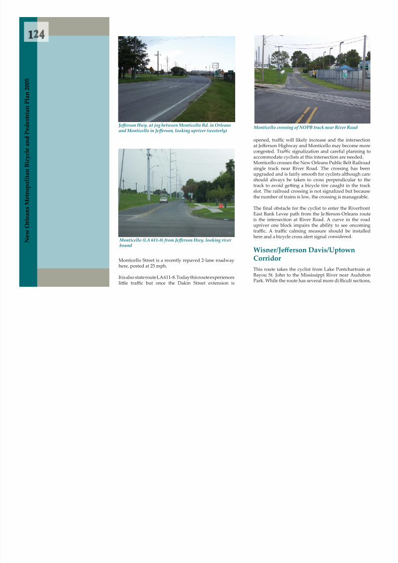
8/6/2019 2005 New Orleans Metropolitan Bicycle and Pedestrian Plan
http://slidepdf.com/reader/full/2005-new-orleans-metropolitan-bicycle-and-pedestrian-plan 131/249
N e w
O r l e a n s
M e t r o p o l i
t a n B i c y c l e a n d
P e d e s t r i a n
P
Monticello Street is a recently repaved 2-lane roadwayhere, posted at 25 mph.
It is also state route LA 611-8. Today this route experiences
lit le traffic but once the Dakin Street extension is
opened, tra ffic will likely increase and the intersectionat Jefferson Highway and Monticello may become morecongested. Tra ffic signalization and careful planning toaccommodate cyclists at this intersection are needed.Monticello crosses the New Orleans Public Belt Railroadsingle track near River Road. The crossing has beenupgraded and is fairly smooth for cyclists although careshould always be taken to cross perpendicular to thetrack to avoid ge t ing a bicycle tire caught in the trackslot. The railroad crossing is not signalized but becausethe number of trains is low, the crossing is manageable.
The nal obstacle for the cyclist to enter the RiverfrontEast Bank Levee path from the Je fferson-Orleans routeis the intersection at River Road. A curve in the roadupriver one block impairs the ability to see oncoming
traffic. A traffic calming measure should be installedhere and a bicycle cross alert signal considered.
Wisner/Je ff erson Da v is/UptownCorridorThis route takes the cyclist from Lake Pontchartrain atBayou St. John to the Mississippi River near AudubonPark. While the route has several more di fficult sections,
Monticello (LA 611-8) from Je ff erson Hwy. looking river bound
Monticello crossing of NOPB track near River Road Je ff erson Hwy. at jog between Monticello Rd. in Orleansand Monticello in Je ff erson, looking upriver (westerly)
5
N e w Orl
Figure 54Jeff erson/Orleans Corridor North

8/6/2019 2005 New Orleans Metropolitan Bicycle and Pedestrian Plan
http://slidepdf.com/reader/full/2005-new-orleans-metropolitan-bicycle-and-pedestrian-plan 132/249
r l e a n s M
e t r o p o l i t a n B i c y c l e
a n d P e d e s t r i a n P l a n 2 0 0 5
Figure 55Jeff erson/Orleans Corridor South
it is, in general, a fairly good route to move north/southin Orleans Parish. There were 18 recorded crashes alongthis route from 1999 to the rst quarter of 2003. Of thesecrashes, all but four occurred along the Je fferson DavisParkway portion of the route.
The route is divided into two basic sections: the Wis-ner Avenue/Je fferson Davis Parkway section and theUptown/Nashville Avenue section (Figures 56, 57, and58). The Wisner Boulevard section joins Uptown bicycletraffic to Mid-City and the Lakefront via relatively low-volume streets. This route is also a critical link for stu-dents and employees of the University of New Orleans,Southern University of New Orleans, and John F. Ken-nedy High School. Other points of interest or employ-ment centers near the route are the Agriculture ResearchCenter at Robert E. Lee and Wisner boulevards, themany amenities of City Park, the Fairgrounds, the NewOrleans Museum of Art, and the Pitot House. The routealso provides an opportunity to peddle along the scenic,

8/6/2019 2005 New Orleans Metropolitan Bicycle and Pedestrian Plan
http://slidepdf.com/reader/full/2005-new-orleans-metropolitan-bicycle-and-pedestrian-plan 133/249
7
N e w O r l

8/6/2019 2005 New Orleans Metropolitan Bicycle and Pedestrian Plan
http://slidepdf.com/reader/full/2005-new-orleans-metropolitan-bicycle-and-pedestrian-plan 134/249
l e a n s M
e t r o p o l i t a n B i c y c l e
a n d P e d e s t r i a n P l a n 2 0 0 5
the Interstate on Wisner Boulevard. The service roadsthat enter and exit onto Zachary Taylor Drive near thePan Am Stadium provide access o ff of and onto WisnerBoulevard. These roads are in fairly poor condition andshould be candidates for resurfacing if possible. Theother City Park roadways named as the bike route, Golf
Drive and Dreyfus Avenue, are in fairly good condition
Beauregard Ave. between Robert E. Lee Blvd. andLakeshore Dr.
Wisner between Harrison and Mirabeau
I-10 and railroad underpass in City Park
aside from road debris that builds up along the shoul-der. The portion that passes under the Interstate, how-ever, is particularly dangerous. The drainage grates onthe downhill portion of the underpass are parallel to cy-clist’s wheels. This type of design can result in dramaticand dangerous crashes as the cyclist’s wheel becomeslodged in the grate resulting in an over the handlebarscrash. These grates should be immediately replacedwith a cycling-friendly design.On the south side of the Interstate, the narrow roadwayscarry a fairly high number of cars to the revenue pro-ducing venues of the museum, the tennis courts, and the
botanical gardens. At certain times, especially aroundthe museum, the amount of tra ffic and on-street park-ing can make cycling di fficult. One solution that could
balance the need of the park to keep generating revenue
while at the same time accommodating cyclists and pe-destrians is a dedicated bike lane through the park. Thepossibility of signing and painting a bike lane throughthe park should be explored.
Moss St. at Carrollton Ave. to Je ff erson Davis Park-way at Iberville St.
The crossing at Moss Street and Carrollton Avenue isheavily tra fficked and potentially dangerous to the bi-
cycle and pedestrian. This intersection should be exam-

8/6/2019 2005 New Orleans Metropolitan Bicycle and Pedestrian Plan
http://slidepdf.com/reader/full/2005-new-orleans-metropolitan-bicycle-and-pedestrian-plan 135/249
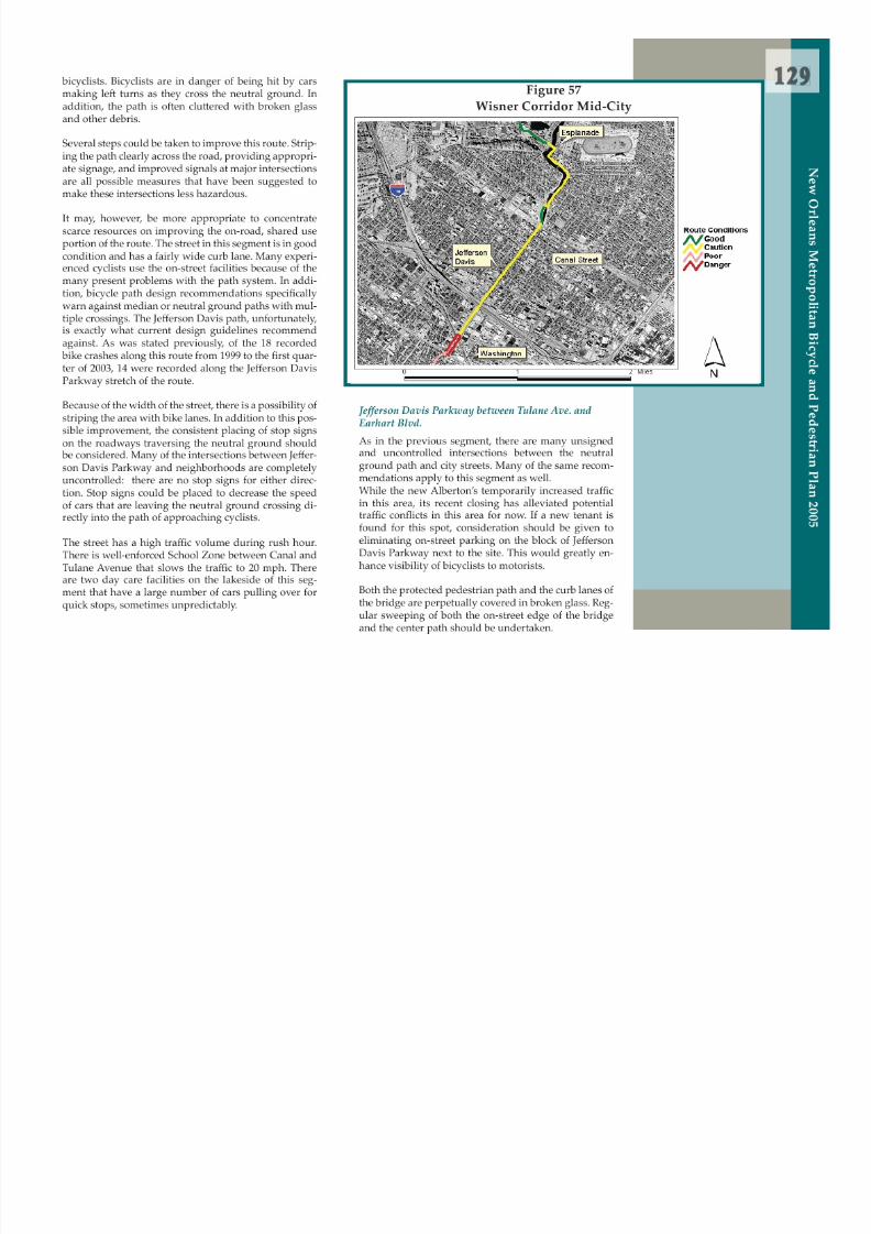
8/6/2019 2005 New Orleans Metropolitan Bicycle and Pedestrian Plan
http://slidepdf.com/reader/full/2005-new-orleans-metropolitan-bicycle-and-pedestrian-plan 136/249
1
P l a n 2 0 0 5
In this segment, the path’s end point deposits bicyclistson the street (and collects them o ff the street) into/fromthe le f lane of tra ffic mid-block. This may be dangerous,as bicycles have to leave and enter the neutral groundpath in a surprising, unsigned and uncontrolled point.
Riverbound : Vendome between Earhart and Fountain- bleau
Lakebound: Octavia between Earhart and Fountainb-leau
In this segment, the lanes of Je fferson Davis Parkway,i l d b id l d li
roadwork involves replacing a bridge, the work couldgo on for some time. E fforts should be made to mediatethis situation with signage and regular street sweepingof the minimal cyclable area.

8/6/2019 2005 New Orleans Metropolitan Bicycle and Pedestrian Plan
http://slidepdf.com/reader/full/2005-new-orleans-metropolitan-bicycle-and-pedestrian-plan 137/249
N e w
O r l e a n s
M e t r o p o l i
t a n B i c y c l e a n d
P e d e s t r i a n previously separated by a wide neutral ground, split
around a city block and become two-way streets. Rather
than keep the corridor on one street, it seems safer todivide the corridor by direction and to keep bicyclestraveling with the ow of tra ffic on separate streets forseveral blocks.
The intersection area in the vicinity of Washington Ave-nue and Earhart Boulevard has become a major problemfor cyclists. Recent roadwork has turned what used to bea difficult crossing with higher tra ffic volume into a con-
fused, high volume intersection crossing. Because the
Traveling riverbound, Vendome Place is a wide streetwith low tra ffic. In the past, the pavement on this sec-tion was in terrible condition, acting as a tra ffic-calmingdevice. The pavement surface has been improved in thisarea, however. Speeds have increased and the ridingconditions have become more challenging. Residentsand bicyclists may desire intentional tra ffic calming de-vices to keep the residential character of the street.
Traveling lakebound, Octavia Street is a wide street withexcellent pavement over most of the segment. There area few big cracks at the lake end of the street that wouldrequire improving.
Nashville between Fountainbleau and Claiborne
Nashville Avenue in this segment has a neutral ground,four travel lanes, and on street parking on both sides.It has an 18-foot curb lane including on-street parking.
The pavement condition is good.
Neutral Ground Path on Je ff erson Davis Parkway be-tween Bienville and Iberville streets
Je ff erson Davis neutral ground at Tulane Avenue, I-10Overpass in the background
1
N e w O r l e
Figure 58Wisner Corridor South (Nash v ille Area)

8/6/2019 2005 New Orleans Metropolitan Bicycle and Pedestrian Plan
http://slidepdf.com/reader/full/2005-new-orleans-metropolitan-bicycle-and-pedestrian-plan 138/249
e a n s M
e t r o p o l i t a n B i c y c l e a n d P e d e s t r i a n P l a n 2 0 0 5
Nashville between Claiborne and Willow
Nashville Avenue in this segment has no neutral groundand two travel lanes. It has a narrow curb lane. School
buses, service vehicles, and school drop-o ffs make use ofthe curbside space. This creates a di fficult and danger-ous situation for cyclists during the heavily tra ffickedaf ernoon and morning rushes. This section is particu-
larly important because it provides a linkage for Tulane/Loyola university students (as well as Ursuline and Mc-Main students) to campuses along Willow Street.
In addition, this segment has extremely poor pavementcondition. It has a dangerous pavement change/crackthat is parallel to the ow of tra ffic and in an area where
bicycles travel. The street bulges--it has a signi cantslope between the centerline and curb. All of these fac-
tors make this section extraordinarily di fficult to traverse
Je ff erson Davis intersection with Earhart andWashington Avenue
during a tra ffic times. Consideration should be given toplacing a bike lane on Nashville Avenue to improve thesituation.
Nashville between Willow and St. Charles
The pavement is slightly be t er in this segment. The curblane is about 16 feet. On-street parking signi cantly re-
duces the area for cyclists, however. With the relativelyhigh volume of tra ffic on this segment, the small cyclingarea makes this stretch fairly di fficult to traverse. Onceagain, a bike lane could signi cantly improve condi-tions.Nashville between St. Charles and Tchoupitoulas
On the riverside of St. Charles Avenue, Nashville Av-enue has newly redone pavement and a wide curb lane(about 22 feet) including on street parking. A f er a few
blocks, at Hurst Street, the road narrows 3 feet to about
1
n P l a n 2 0 0 5
The Esplanade A venue BicycleCorridorThe Esplanade Avenue Corridor can provide both astrategic and direct route for bicycling commuters as
well as a unique, historic bicycling experience to localsand tourists alike. It is already used by many FrenchQuarter and CBD workers who bike to work from theirhomes in Treme, Esplanade Ridge, Faubourg St. John,Mid-City and beyond. The Esplanade Corridor withits rich Creole history and direct linkage to City Parkand the neighborhoods along the Esplanade Ridge is
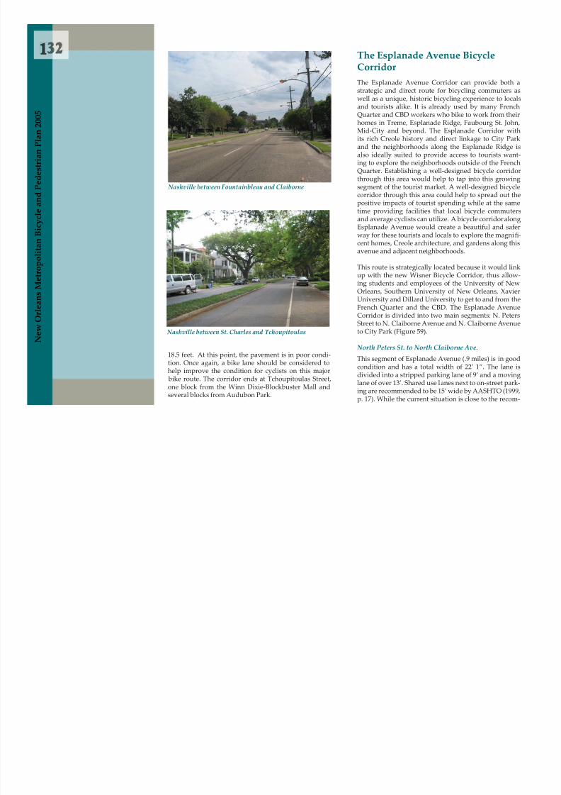
8/6/2019 2005 New Orleans Metropolitan Bicycle and Pedestrian Plan
http://slidepdf.com/reader/full/2005-new-orleans-metropolitan-bicycle-and-pedestrian-plan 139/249
N e w
O r l e a n s
M e t r o p o l i
t a n B i c y c l e a n d
P e d e s t r i a n
18.5 feet. At this point, the pavement is in poor condi-tion. Once again, a bike lane should be considered tohelp improve the condition for cyclists on this major
bike route. The corridor ends at Tchoupitoulas Street,one block from the Winn Dixie-Blockbuster Mall andseveral blocks from Audubon Park.
Nashville between St. Charles and Tchoupitoulas
Nashville between Fountainbleau and Claiborne
and the neighborhoods along the Esplanade Ridge isalso ideally suited to provide access to tourists want-ing to explore the neighborhoods outside of the FrenchQuarter. Establishing a well-designed bicycle corridorthrough this area would help to tap into this growingsegment of the tourist market. A well-designed bicyclecorridor through this area could help to spread out thepositive impacts of tourist spending while at the sametime providing facilities that local bicycle commutersand average cyclists can utilize. A bicycle corridor alongEsplanade Avenue would create a beautiful and saferway for these tourists and locals to explore the magni -cent homes, Creole architecture, and gardens along this
avenue and adjacent neighborhoods.
This route is strategically located because it would linkup with the new Wisner Bicycle Corridor, thus allow-ing students and employees of the University of NewOrleans, Southern University of New Orleans, XavierUniversity and Dillard University to get to and from theFrench Quarter and the CBD. The Esplanade AvenueCorridor is divided into two main segments: N. PetersStreet to N. Claiborne Avenue and N. Claiborne Avenueto City Park (Figure 59).
North Peters St. to North Claiborne Ave.
This segment of Esplanade Avenue (.9 miles) is in goodcondition and has a total width of 22’ 1”. The lane isdivided into a stripped parking lane of 9’ and a movinglane of over 13’. Shared use lanes next to on-street park-ing are recommended to be 15’ wide by AASHTO (1999,p. 17). While the current situation is close to the recom-
3
N e w O r l ea
mended width, future plans should probably decreasethe parking lane by a foot to provide the slight extrawidth that would make this section optimal. In addi-tion, tra ffic volume is relatively low and debris is notof en a problem. Two other improvements could helpto improve this section: 1) signage to mark the route asa bicycle route and 2) reduced speed limit to 25 milesper hour to make the route more conducive to a sharedtraffic environment. In addition, the intersection ofEsplanade Avenue and Claiborne Avenue poses someproblems. Tra ffic turning onto Claiborne Avenue o f endoes not habitually yield to bicycles crossing EsplanadeA A bi ti f i d f t i
Figure 59Esplanade Corridor

8/6/2019 2005 New Orleans Metropolitan Bicycle and Pedestrian Plan
http://slidepdf.com/reader/full/2005-new-orleans-metropolitan-bicycle-and-pedestrian-plan 140/249
a n s M e t r o p o l i t a n B i c y c l e a n d P e d e s t r i a n P l a n 2 0 0 5
Avenue. A combination of increased enforcement, im-proved signage, and/or a change in the light cycle forturning vehicles should be considered for this intersec-
tion.North Claiborne Ave. to Wisner Blvd.
On this segment of Esplanade Avenue (1.6 miles), thestreet is in fair to poor condition with very rough pave-ment as well as some potholes. This segment currentlyhas two moving car lanes and one parking lane with atotal width of 26’ 4”. The le f moving lane is 10’ wide.This leaves 16’ 4” for the right moving lane as well as
the parking lane. When there are cars parked alongthis segment of Esplanade Avenue, there is simply notenough room for two cars to drive side-by-side safely.When a bicycle is included into this narrow space, thesituation can become dangerous. All 10 recorded bikecrashes along the Esplanade Avenue corridor from 1999to the rst quarter of 2003 occurred in this stretch. Spe-ci cally, all 10 bike crashes occurred between N. Galvezand N. Broad streets.
This stretch of road would be a perfect candidate fora bicycle lane. AASHTO (1999) recommends that bikelanes between the parking area and road lane have aminimum width of 5 feet with a 6 inch solid line sepa-rating road tra ffic and a 4 inch solid line separating the
bike lane from the parking lane (p. 22). If one movinglane was removed along Esplanade Avenue, the dimen-sions of this segment from curb to neutral ground could
be: a parking lane of 8 feet, a bicycle lane of 5 feet 10
Esplanade Avenue between Royal and Bourbon streets
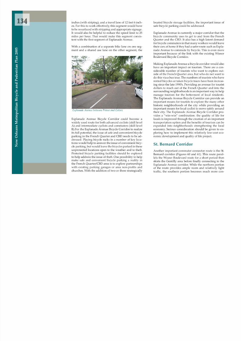
8/6/2019 2005 New Orleans Metropolitan Bicycle and Pedestrian Plan
http://slidepdf.com/reader/full/2005-new-orleans-metropolitan-bicycle-and-pedestrian-plan 141/249
5
N e w O r l e a
Figure 60St. Bernard Corridor North

8/6/2019 2005 New Orleans Metropolitan Bicycle and Pedestrian Plan
http://slidepdf.com/reader/full/2005-new-orleans-metropolitan-bicycle-and-pedestrian-plan 142/249
a n s M e t r o p o l i t a n B i c y c l e a n d P e d e s t r i a n P l a n
2 0 0 5
gested. All recorded bike crashes in this corridor from1999 to the rst quarter of 2003 occurred on the south-ern portion of the route. The beauty of this route is thatit connects to Esplande Avenue, a highly desirable bikeroute, and is one of the few locations one can travel un-der the Interstate. It provides the shortest route betweenthe lake and the French Quarter/CBD area.
The rst stretch of the route starts near the mouth ofBayou St. John at Lakeshore Drive. The stretch betweenLakeshore Drive and Harrison Avenue has low tra fficvolumes and a wide outside lane with a largely unusedparking lane. However, the pavement conditions wors-en between of Robert E. Lee Boulevard and MirabeauAvenue with many cracks, potholes and a large amountsof set ling. At Harrison Avenue, the tra ffic (both pedes-trian and motor vehicle) becomes heavier and the tra fficconditions more congested. There are a large number of
pedestrians crossing from the St. Bernard Housing units between Harrison Avenue and the Interstate to commer-cial/medical land uses across St. Bernard Avenue. Two
bike crashes were recorded on this stretch.As the route passes under the Interstate-610 and pastthe entrance and exit ramps on the west (it is a half clo-ver leaf design rather than a full clover leaf with twoinstead of four ramps), tra ffic speeds tend to rise. There
are sweeping right hand turns entering and exiting theramps along with signals for straight ahead movementsat St. Bernard Avenue. Caution is advised as motor driv-ers transition to or from 70 mph at St. Bernard Avenue,a major arterial in this area, creating a more di fficultsituation for riders. Drainage grates under the NorfolkSouthern elevated rail bridge next to I-610 are also ahazard for narrow bicycle tires and debris tends to col-lect under the overpass. These can be easily remediedwith regular sanitation and replacement with more bikefriendly grate design.
St. Bernard riverbound at I-610 entrance ramp

8/6/2019 2005 New Orleans Metropolitan Bicycle and Pedestrian Plan
http://slidepdf.com/reader/full/2005-new-orleans-metropolitan-bicycle-and-pedestrian-plan 143/249

8/6/2019 2005 New Orleans Metropolitan Bicycle and Pedestrian Plan
http://slidepdf.com/reader/full/2005-new-orleans-metropolitan-bicycle-and-pedestrian-plan 144/249

8/6/2019 2005 New Orleans Metropolitan Bicycle and Pedestrian Plan
http://slidepdf.com/reader/full/2005-new-orleans-metropolitan-bicycle-and-pedestrian-plan 145/249

8/6/2019 2005 New Orleans Metropolitan Bicycle and Pedestrian Plan
http://slidepdf.com/reader/full/2005-new-orleans-metropolitan-bicycle-and-pedestrian-plan 146/249

8/6/2019 2005 New Orleans Metropolitan Bicycle and Pedestrian Plan
http://slidepdf.com/reader/full/2005-new-orleans-metropolitan-bicycle-and-pedestrian-plan 147/249
1
N e w O r l e a ns
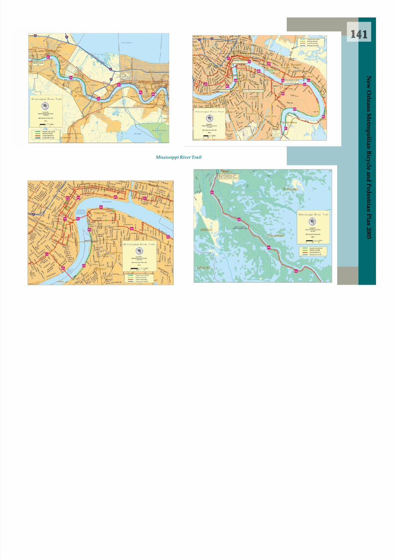
8/6/2019 2005 New Orleans Metropolitan Bicycle and Pedestrian Plan
http://slidepdf.com/reader/full/2005-new-orleans-metropolitan-bicycle-and-pedestrian-plan 148/249
s M e t r o p o l i t a n B i c y c l e a n d P e d e s t r i a n P l a n
2 0 0 5
Mississippi River Trail
8/6/2019 2005 New Orleans Metropolitan Bicycle and Pedestrian Plan
http://slidepdf.com/reader/full/2005-new-orleans-metropolitan-bicycle-and-pedestrian-plan 149/249
3
N e w O r l e a nsCamp St one-way eastbound at Pontchartrain Exprssway
Tchoupitoulas Street crossing should be avoided entire-ly. It is the major truck route connecting the Port of NewOrleans to the Pontchartrain Expressway and I-10.
Camp Street fron Clio to Canal Streets
From Clio Street, the route turns le f onto Camp Street,a one-way street going downriver to the CBD under thePontchartrain Expressway. Camp Street is particularlyharrowing because a f er passing under the Expressway,off-ramp tra ffic from the Expressway enters Camp Streeton the right side. Cyclists can be caught between lanesand must be very careful to watch for exiting vehicles. Atwo-phased signal is planned for this intersection (in theheart of the Museum District) to allow a cyclist time to

8/6/2019 2005 New Orleans Metropolitan Bicycle and Pedestrian Plan
http://slidepdf.com/reader/full/2005-new-orleans-metropolitan-bicycle-and-pedestrian-plan 150/249
s M e t r o p o l i t a n B i c y c l e a n d P e d e s t r i a n P l a n
2 0 0 5
Magazine Street on-way westbound at PontchartrainExpressway (ramp modi caitons under construction)
Camp St. one way eastbound at Pontchartrain Exprsswaywith on-street parking underunderpass
Baronne St. on-way westbound at Pontchartrain Express-way with on-street parking
heart of the Museum District) to allow a cyclist time tomove into the right lane without competing with down
ramp tra ffic. Camp Street riders will
nd fairly high traf- c volumes and a parking lane. Travel lanes are fairlygenerous but no bicycle striping has been instituted yet.The Camp Street corridor is a top candidate for a future
bike lane as well as Magazine Street, the correspondingreturn route.
Ferry Tales
Six ferries operate in the New Orleans MRT region. Day
of week and hours of operation vary so plan your bicycletrip times accordingly. Like bike on bus, ferries become

8/6/2019 2005 New Orleans Metropolitan Bicycle and Pedestrian Plan
http://slidepdf.com/reader/full/2005-new-orleans-metropolitan-bicycle-and-pedestrian-plan 151/249
5
N e w O r l e a n s M
Continuing Downriver to the French Quarter
Chartres Street: Canal Street to Poland Avenue to St.Claude Ave.
Camp Street is renamed to Chartres Street as it entersthe French Quarter a f er crossing one of the oldest andwidest downtown streets in America, Canal Street. Ca-nal Street is a bustling main street with an enormousnumber of pedestrians, cars, bus tours, taxi’s and it ac-commodates the world’s longest continuously operatedstreetcar. Use caution biking across Canal Street.
All streets in the Quarter are narrow and of a pre-auto-mobile era. Chartres Street stops brie y at the JacksonC th d l d th i k g i th th id
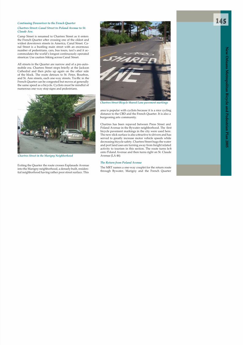
8/6/2019 2005 New Orleans Metropolitan Bicycle and Pedestrian Plan
http://slidepdf.com/reader/full/2005-new-orleans-metropolitan-bicycle-and-pedestrian-plan 152/249
M e t r o p o l i t a n B i c y c l e a n d P e d e s t r i a n P l a n 2 0 0 5
Cathedral and then picks up again on the other sideof the block. The route detours to St. Peter, Bourbon,and St. Ann streets, each one-way streets. Tra ffic in theFrench Quarter can be congested but moves at generallythe same speed as a bicycle. Cyclists must be mindful ofnumerous one-way stop signs and pedestrians.
Exiting the Quarter the route crosses Esplanade Avenueinto the Marigny neighborhood, a densely built, residen-tial neighborhood having rather poor street surface. This
Chartres Street in the Marigny Neighborhood
area is popular with cyclists because it is a nice cyclingdistance to the CBD and the French Quarter. It is also a burgeoning arts community.
Chartres has been repaved between Press Street andPoland Avenue in the Bywater neighborhood. The rst
bicycle pavement markings in the city were used here.The new slick surface is also a t ractive to drivers and hasserved to greatly increase motor vehicle speeds whiledecreasing bicycle safety. Chartres Street hugs the waterand port land uses are turning away from freight relatedactivity to tourism in this section. The route turns le f onto Poland Avenue and then turns right on St. ClaudeAvenue (LA 46).
The Return from Poland Avenue
The MRT names a one-way couplet for the return routethrough Bywater, Marigny and the French Quarter
Chartres Street Bicycle Shared Lane pavement markings
1
t r i a n P l a n 2 0 0 5
neighborhoods. These are Burgundy Street(one-waydownriver) and Dauphine Street (one-way upriver).Dauphine Street turns into Baronne Street as it entersthe CBD. Burgundy Street becomes O’Keefe Street as itenters the CBD. These two streets are perhaps the bestthoroughfares for traversing the French Quarter and the
CBD as the tra ffic moves near the speed of a bicycle andthey are a distance from the heaviest tourist tra ffic.

8/6/2019 2005 New Orleans Metropolitan Bicycle and Pedestrian Plan
http://slidepdf.com/reader/full/2005-new-orleans-metropolitan-bicycle-and-pedestrian-plan 153/249
N e w
O r l e a n s
M e t r o p o l
i t a n B i c y c l e a n d
P e d e s t
St. Claude Avenue: Poland to Delery(Jackson Barracks)
St. Claude Avenue is a designated truck and bus routewith high volumes of truck, bus, pedestrian and bicycletraffic. It is one of only two connecting corridors intoSt. Bernard Parish and services numerous commercialand industrial businesses. It is a divided highway with
two travel lanes and one parking lane in each direction.The parking lane is generous but not wide enough fora bicycle t with comfort. For these reasons, the MRTdarts onto parallel neighboring streets when possible asit makes its way toward St. Bernard Parish.
While bicycles are allowed on the St. Claude Bridge overthe Industrial Canal, safety is low. There is no shoulderon the bridge and travel lanes are narrow. St. ClaudeBridge is unusually dangerous for cyclists.
St. Claude Bridge poses major hazard for cyclists
The St. Claude Bridge has a three to four foot pedestrianwalkway that is accessible from the service road. Bicy-cles can be carried up a staircase and be walked across,although di fficult. Another alternative is to take advan-tage of the new RTA bike on bus equipment that allowsa rider and his bike to board a f er certi cation.
St. Claude Avenue is a busy thoroughfare that servicesmultiple surrounding neighborhoods and commercial/heavy industrial properties downriver from the CBD. St.Claude Avenue, therefore, is an exceedingly importantcorridor for many types of tra ffic. Communities alongSt. Claude Avenue walk and bicycle frequently in thearea to neighborhood destinations.
The MRT route continues downriver and detours into
the Holy Cross neighborhood on Forstall Street (two-way) for one block. The MRT turns le f onto N. Ram-part Street (two-way) and travels through the residentialneighborhood to Delery Street (two-way), ending at the
Jackson Barracks. The route turns le f on Delery Streetand returns to St. Claude Avenue. St. Claude Avenuechanges its name at the border with St. Bernard Parish
becoming St. Bernard Highway
St. Claude Bridge and Pedestrian Walkway
7
N e w O r l e a n s M
St. Bernard Highway near Norfolk SouthernRailroad crossing
St. Bernard Highway commercial strip

8/6/2019 2005 New Orleans Metropolitan Bicycle and Pedestrian Plan
http://slidepdf.com/reader/full/2005-new-orleans-metropolitan-bicycle-and-pedestrian-plan 154/249
St. Bernard Hwy: Jackson Barracks to Murphy Oil
The MRT continues on St. Bernard Highway (LA 46) fornearly ten miles due to industrial uses blocking accessto the riverfront. This section is a busy state highwaywith lots of trucks. It does, however, pass the entranceto the Chalme t e Bat le eld and National Cemetery, the
M e t r o p o l i t a n B i c y c l e a n d P e d e s t r i a n P l a n 2 0 0 5
St. Claude Service Road to bedestrian bridge
Cyclists carrying bike up the stairs to the St. Claude
pedestrian bridge
location of the decisive American victory of the Ba t le ofNew Orleans in 1815 over the British. The proximity ofthe Norfolk Southern Railroad track on the riverside ofSt. Bernard Hwy and lack of sidewalks make the shoul-der the only area for pedestrians as well.
St. Bernard Highway was widened and repaved nearCenter Street near the Orleans/St. Bernard parish lineand continues past Paris Road (I-510). Rumble strips,unfortunately, were gouged into the asphalt overlayalong the corridor making riding di fficult. The stripingfalls short of a full four foot shoulder in some sections.
Rumble strips on LA 46 on newly repaved surface
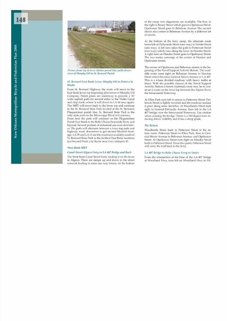
8/6/2019 2005 New Orleans Metropolitan Bicycle and Pedestrian Plan
http://slidepdf.com/reader/full/2005-new-orleans-metropolitan-bicycle-and-pedestrian-plan 155/249

8/6/2019 2005 New Orleans Metropolitan Bicycle and Pedestrian Plan
http://slidepdf.com/reader/full/2005-new-orleans-metropolitan-bicycle-and-pedestrian-plan 156/249

8/6/2019 2005 New Orleans Metropolitan Bicycle and Pedestrian Plan
http://slidepdf.com/reader/full/2005-new-orleans-metropolitan-bicycle-and-pedestrian-plan 157/249

8/6/2019 2005 New Orleans Metropolitan Bicycle and Pedestrian Plan
http://slidepdf.com/reader/full/2005-new-orleans-metropolitan-bicycle-and-pedestrian-plan 158/249
Jourdan Road to Sen. Ted Hickey Bridge
This route has very low tra ffic on weekends and minimaltraffic on weekdays. Again, Share the Road signs would
be an improvement and some sections of the roadwayare in poor (but usable) condition.
Chef Menteur Highway (Hwy 90)Many of the issues associated with the Chef MenteurHighway segment are similar to those associated withthe Almonaster Boulevard segment, except that in ad-dition to shoulder cleaning and maintenance concernsthere is an approximately one mile segment of shoulderthat is reduced to approximately one foot of usable widthdue to the installation of rumble strips. This route is par-
tained. Because this is a four-lane roadway with verylight weekend tra ffic, motorized vehicles can easily passcyclists on the roadway without interference. However,during weekday commuter hours cyclists would gener-ally need to ride on the shoulder for safety. The overpassconnecting Almonaster Boulevard to Jourdan Road haslit le room for a separate bike lane, and less experiencedcyclists are likely to be uncomfortable with using it.
1
e s t r i a n P l a n 2 0 0 5

8/6/2019 2005 New Orleans Metropolitan Bicycle and Pedestrian Plan
http://slidepdf.com/reader/full/2005-new-orleans-metropolitan-bicycle-and-pedestrian-plan 159/249
ticularly nice for bicyclists because it travels through theBayou Sauvage National Wildlife Refuge and has a veryminimal number of intersections. Going towards NewOrleans, however, tra ffic becomes more intense andstaying on Chef Menteur Highway without switchingto either the Hayne Boulevard or the Almonaster Boule-vard segments is not recommended.
Man rides along Hwy. 90 returning from a shing tripalong Hwy. 90
Almonaster Overpass
Hayne Blvd. with Sen. Ted Hickey Bridge in background
N e w
O r l e a n s
M e t r o p o
l i t a n B i c y c l e a n d
P e d e
New Orleans East Trails Development
The Bayou Sauvage/Irish Bayou area presents an excel-lent opportunity for development of a bicycle/pedestriantrail that would provide New Orleans citizens the samerecreational opportunities provided by the TammanyTrace on the Northshore and would greatly increasenon-motorized access to the Bayou Sauvage NationalWildlife Refuge. It appears that it would be relativelyeasy to develop this route from Li t le Woods at the eastend of Hayne Boulevard to the Irish Bayou exit at I-10and the Highway 11 Bridge across Lake Pontchartrain.There is an existing bike path in this area but it is dif- cult to access and is in poor condition. Ideally, a pe-destrian/bicycle bridge over I-10 and a paved shoulder
3
N e w O r l e a n s M
addition to Highway 11 through Irish bayou and theBayou Sauvage National Wildlife Refuge would connectthis route from Li t le Woods through to Highway 90 atPowers Junction, thereby providing a very signi cantaddition to the ring around Lake Pontchartrain route.
La t e Corridor La t e Corridor Greenway is a multi-phase, 2.8 mileproject to convert the land along the former CarondeletCanal/Norfolk Southern Rail Corridor from RampartStreet to City Park Avenue into a multiuse urban trailand linear green space. The project will provide a muchneeded bicycle and pedestrian connection between theMid City, Treme, and Tulane/Gravier neighborhoodsto the future Wisner Bike Path, the Je fferson Davis bike
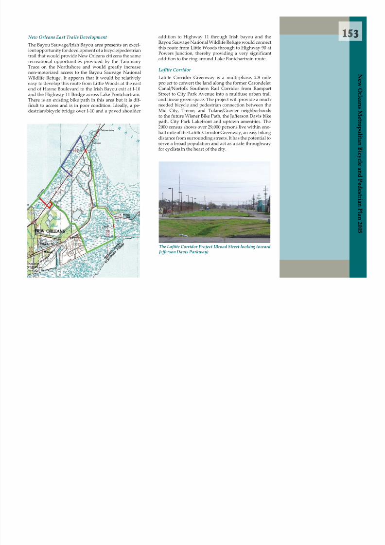
8/6/2019 2005 New Orleans Metropolitan Bicycle and Pedestrian Plan
http://slidepdf.com/reader/full/2005-new-orleans-metropolitan-bicycle-and-pedestrian-plan 160/249
e t r o p o l i t a n B i c y c l e a n d P e d e s t r i a n P l a n 2 0 0 5
,path, City Park Lakefront and uptown amenities. The2000 census shows over 29,000 persons live within one-half mile of the La t e Corridor Greenway, an easy bikingdistance from surrounding streets. It has the potential toserve a broad population and act as a safe throughwayfor cyclists in the heart of the city.
The La t e Corridor Project IBroad Street looking toward Je ff erson Davis Parkway)

8/6/2019 2005 New Orleans Metropolitan Bicycle and Pedestrian Plan
http://slidepdf.com/reader/full/2005-new-orleans-metropolitan-bicycle-and-pedestrian-plan 161/249

8/6/2019 2005 New Orleans Metropolitan Bicycle and Pedestrian Plan
http://slidepdf.com/reader/full/2005-new-orleans-metropolitan-bicycle-and-pedestrian-plan 162/249

8/6/2019 2005 New Orleans Metropolitan Bicycle and Pedestrian Plan
http://slidepdf.com/reader/full/2005-new-orleans-metropolitan-bicycle-and-pedestrian-plan 163/249

8/6/2019 2005 New Orleans Metropolitan Bicycle and Pedestrian Plan
http://slidepdf.com/reader/full/2005-new-orleans-metropolitan-bicycle-and-pedestrian-plan 164/249

8/6/2019 2005 New Orleans Metropolitan Bicycle and Pedestrian Plan
http://slidepdf.com/reader/full/2005-new-orleans-metropolitan-bicycle-and-pedestrian-plan 165/249

8/6/2019 2005 New Orleans Metropolitan Bicycle and Pedestrian Plan
http://slidepdf.com/reader/full/2005-new-orleans-metropolitan-bicycle-and-pedestrian-plan 166/249
State Laws

8/6/2019 2005 New Orleans Metropolitan Bicycle and Pedestrian Plan
http://slidepdf.com/reader/full/2005-new-orleans-metropolitan-bicycle-and-pedestrian-plan 167/249

8/6/2019 2005 New Orleans Metropolitan Bicycle and Pedestrian Plan
http://slidepdf.com/reader/full/2005-new-orleans-metropolitan-bicycle-and-pedestrian-plan 168/249

8/6/2019 2005 New Orleans Metropolitan Bicycle and Pedestrian Plan
http://slidepdf.com/reader/full/2005-new-orleans-metropolitan-bicycle-and-pedestrian-plan 169/249

8/6/2019 2005 New Orleans Metropolitan Bicycle and Pedestrian Plan
http://slidepdf.com/reader/full/2005-new-orleans-metropolitan-bicycle-and-pedestrian-plan 170/249

8/6/2019 2005 New Orleans Metropolitan Bicycle and Pedestrian Plan
http://slidepdf.com/reader/full/2005-new-orleans-metropolitan-bicycle-and-pedestrian-plan 171/249

8/6/2019 2005 New Orleans Metropolitan Bicycle and Pedestrian Plan
http://slidepdf.com/reader/full/2005-new-orleans-metropolitan-bicycle-and-pedestrian-plan 172/249

8/6/2019 2005 New Orleans Metropolitan Bicycle and Pedestrian Plan
http://slidepdf.com/reader/full/2005-new-orleans-metropolitan-bicycle-and-pedestrian-plan 173/249
7Mandeville, Lacombe, and Slidell. In the TammanyTrace right-of-way there are parallel paths for equestri-ans and a paved bicycle/walking path. It has its own setof rules governing bicycles and their use. The Trace usesa protocol for mixed non-motorized tra ffic that is com-mon etique t e for most trails around the country.
Roller bladers yield to cyclists.Cyclists yield to joggers.Joggers yield to walkers.Walkers yield to horses.
St. Tammany Parish Code of Ordinances, Chapter 15,Offenses and Miscellaneous, Article IX states,“It shall beunlawful for any person, whether on foot, bicycle, or ina vehicle of any type, to travel, loiter, walk, play, jog, tra-
verse or encroach upon any levee within the boundariesf D i Di t i t N 4 ”
Tab le 20Multi-Jurisdictional Comparison of Bicycle and Pedestrian Laws
Bicycle Beha v ior
L o u i s i a n a
A r k a n
s a s
M i s s i s s i p p i
T e x a s J e ff e r s o n
O r l e a n s
P l a q u e m
i n e s
S t . C h a r l e s
S t . B e r n a r d
S t . T a m m a n y
Have same road rights and duties as other vehicles, excepton Interstate Highways X X X X X X X X X XMust ride on right side of road, near to edge. X X X X X X X X X XRide no more than 2 abreast X X X X X X X X X XKeep 1 hand on handle bars X X X X X X X X X X
Ride on separate path when such is provided (see footnote) X X X X X X X
N e w O r l e a n s M e t rop
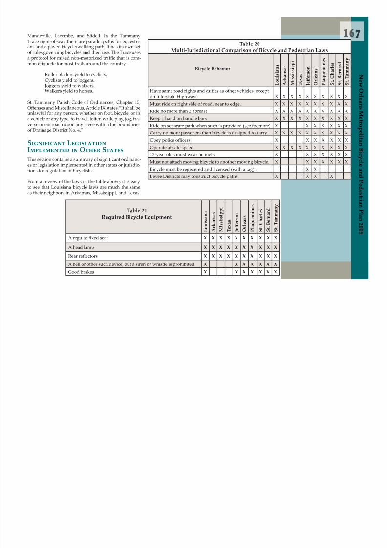
8/6/2019 2005 New Orleans Metropolitan Bicycle and Pedestrian Plan
http://slidepdf.com/reader/full/2005-new-orleans-metropolitan-bicycle-and-pedestrian-plan 174/249
verse or encroach upon any levee within the boundariesof Drainage District No. 4.”
Significant Legislation Implemented in O ther StatesThis section contains a summary of signi cant ordinanc-es or legislation implemented in other states or jurisdic-tions for regulation of bicyclists.
From a review of the laws in the table above, it is easyto see that Louisiana bicycle laws are much the sameas their neighbors in Arkansas, Mississippi, and Texas.
Ride on separate path when such is provided (see footnote) X X X X X X XCarry no more passeners than bicycle is designed to carry X X X X X X X X X XObey police o fficers. X X X X X X XOperate at safe speed. X X X X X X X X X X12-year olds must wear helmets X X X X X X XMust not a t ach moving bicycle to another moving bicycle. X X X X X X XBicycle must be registered and licensed (with a tag). X X
Levee Districts may construct bicycle paths. X X X X
Tab le 21Required Bicycle Equipment
L o u i s i a n a
A
r k a n s a s
M
i s s i s s i p p i
T e x a s
J e ff e r s o n
O
r l e a n s
P l a q u e m i n e s
S t . C h a r l e s
S t . B e r n a r d
S t . T a m m a n y
A regular xed seat X X X X X X X X X X
A head lamp X X X X X X X X X X
Rear re ectors X X X X X X X X X X
A bell or other such device, but a siren or whistle is prohibited X X X X X X X
Good brakes X X X X X X X
r o p o l i t a n B i c y c l e a n d P e d e s t r i a n P l a n 2 0 0 5
8/6/2019 2005 New Orleans Metropolitan Bicycle and Pedestrian Plan
http://slidepdf.com/reader/full/2005-new-orleans-metropolitan-bicycle-and-pedestrian-plan 175/249

8/6/2019 2005 New Orleans Metropolitan Bicycle and Pedestrian Plan
http://slidepdf.com/reader/full/2005-new-orleans-metropolitan-bicycle-and-pedestrian-plan 176/249

8/6/2019 2005 New Orleans Metropolitan Bicycle and Pedestrian Plan
http://slidepdf.com/reader/full/2005-new-orleans-metropolitan-bicycle-and-pedestrian-plan 177/249

8/6/2019 2005 New Orleans Metropolitan Bicycle and Pedestrian Plan
http://slidepdf.com/reader/full/2005-new-orleans-metropolitan-bicycle-and-pedestrian-plan 178/249

8/6/2019 2005 New Orleans Metropolitan Bicycle and Pedestrian Plan
http://slidepdf.com/reader/full/2005-new-orleans-metropolitan-bicycle-and-pedestrian-plan 179/249

8/6/2019 2005 New Orleans Metropolitan Bicycle and Pedestrian Plan
http://slidepdf.com/reader/full/2005-new-orleans-metropolitan-bicycle-and-pedestrian-plan 180/249
8/6/2019 2005 New Orleans Metropolitan Bicycle and Pedestrian Plan
http://slidepdf.com/reader/full/2005-new-orleans-metropolitan-bicycle-and-pedestrian-plan 181/249
5Recommendation Five
The Regional Planning Commission in partnershipwith the Federal Highway Administration, the Depart-ment of Transportation and Development, state bicycleand pedestrian advocates and the Louisiana HighwaySafety Commission should work together to in uence
signi
cant changes in state statutes to comprehensivelyclarify and detail the rights and responsibilities of mo-torists, bicyclists and pedestrians and institute new pro-gressive laws that will help reduce incidents and fatali-ties in all areas of the state (urban and rural).
N e w O r l e a n s M e t r o pol

8/6/2019 2005 New Orleans Metropolitan Bicycle and Pedestrian Plan
http://slidepdf.com/reader/full/2005-new-orleans-metropolitan-bicycle-and-pedestrian-plan 182/249
o l i t a n B i c y c l e a n d P e d e s t r i a n P l a n 2 0 0 5

8/6/2019 2005 New Orleans Metropolitan Bicycle and Pedestrian Plan
http://slidepdf.com/reader/full/2005-new-orleans-metropolitan-bicycle-and-pedestrian-plan 183/249

8/6/2019 2005 New Orleans Metropolitan Bicycle and Pedestrian Plan
http://slidepdf.com/reader/full/2005-new-orleans-metropolitan-bicycle-and-pedestrian-plan 184/249
Law Enforcement Practices

8/6/2019 2005 New Orleans Metropolitan Bicycle and Pedestrian Plan
http://slidepdf.com/reader/full/2005-new-orleans-metropolitan-bicycle-and-pedestrian-plan 185/249

8/6/2019 2005 New Orleans Metropolitan Bicycle and Pedestrian Plan
http://slidepdf.com/reader/full/2005-new-orleans-metropolitan-bicycle-and-pedestrian-plan 186/249

8/6/2019 2005 New Orleans Metropolitan Bicycle and Pedestrian Plan
http://slidepdf.com/reader/full/2005-new-orleans-metropolitan-bicycle-and-pedestrian-plan 187/249
8/6/2019 2005 New Orleans Metropolitan Bicycle and Pedestrian Plan
http://slidepdf.com/reader/full/2005-new-orleans-metropolitan-bicycle-and-pedestrian-plan 188/249

8/6/2019 2005 New Orleans Metropolitan Bicycle and Pedestrian Plan
http://slidepdf.com/reader/full/2005-new-orleans-metropolitan-bicycle-and-pedestrian-plan 189/249

8/6/2019 2005 New Orleans Metropolitan Bicycle and Pedestrian Plan
http://slidepdf.com/reader/full/2005-new-orleans-metropolitan-bicycle-and-pedestrian-plan 190/249
1Tab le 23
Information Requests on Bicycle Enforcement to Local Police, Spring 2002
Unit/ Municipality
A t e m p t e d
I n t e r v
i e w e d
Summary
NOPD 1st DistrictX X Bicycle officers effective in dealling with bicyclists. Bicy-
cling is not a priority of NOPD. Policemen should be on bikes more
NOPD 2nd DistrictX X Very lit le at ention is paid to bicyclists, but more police-
men should be on bicycles. It would help the police do their job be t er
NOPD 3rd District X
NOPD 4th District X X Priorities do not allow for bicycle awarenessNOPD 5th District X X Cite bicyclists in relation to accidents, but not proactivelyNOPD 6th District X a n d P
e d e s t r i a n P l a n 2 0 0 5

8/6/2019 2005 New Orleans Metropolitan Bicycle and Pedestrian Plan
http://slidepdf.com/reader/full/2005-new-orleans-metropolitan-bicycle-and-pedestrian-plan 191/249
NOPD 6th District XNOPD 7th District XNOPD 8th District XHarahan X
Kenner X X Room for improvement in bicycle training for o fficers, butthere is no real need.
JPSO 1st District X JPSO 2nd District X JPSO 3rd District JPSO 4th DistrictMandevilleCovington XSlidell
Gretna X X Bicycle officer seriously a t empts to promote safety of bicyclists: alerts people who ride the wrong way, enforces bicycle registration, and promotes bicycle education.
Plquemines ParishSheriffs OfficeSt. Bernard ParishSheriffs Office
N e w
O r l e a n s
M e t r o p o l i t a n
B i c y c l e
5
N e w O r l e a n s M e t r o
p o l i t a
Police O ffi cer Phone Sur vey Questions
Interviewer:
Name of O fficer:Position:
City:Department:
1. When on patrol do you pay a t ention to bicyclists?
2. Have you ever given a warning or citation to a bicyclist?
3. Have you ever given a warning or a citation to amotorist in relation to a bicycle incident?
a. Why or why not?

8/6/2019 2005 New Orleans Metropolitan Bicycle and Pedestrian Plan
http://slidepdf.com/reader/full/2005-new-orleans-metropolitan-bicycle-and-pedestrian-plan 192/249
a n B i c y c l e a n d P e d e s t r i a n P l a n 2 0 0 5
4. From a realistic standpoint, should bicycle regula-tions be enforced?
a. If yes, which ones? If no, why not?
5. What is the largest barrier to increasing bicycleregulation enforcement?
6. In the long term, what is the best way to increase bicycle safety in the New Orleans area?
7. In the short term, what is the simplest way toincrease bicycle safety in the New Orleans area?
8. How were you trained to handle bicyclists?
9. What improvements could be made in the trainingprocess to increase police awareness of bicycles?

8/6/2019 2005 New Orleans Metropolitan Bicycle and Pedestrian Plan
http://slidepdf.com/reader/full/2005-new-orleans-metropolitan-bicycle-and-pedestrian-plan 193/249

8/6/2019 2005 New Orleans Metropolitan Bicycle and Pedestrian Plan
http://slidepdf.com/reader/full/2005-new-orleans-metropolitan-bicycle-and-pedestrian-plan 194/249
Education and Training

8/6/2019 2005 New Orleans Metropolitan Bicycle and Pedestrian Plan
http://slidepdf.com/reader/full/2005-new-orleans-metropolitan-bicycle-and-pedestrian-plan 195/249
8/6/2019 2005 New Orleans Metropolitan Bicycle and Pedestrian Plan
http://slidepdf.com/reader/full/2005-new-orleans-metropolitan-bicycle-and-pedestrian-plan 196/249
8/6/2019 2005 New Orleans Metropolitan Bicycle and Pedestrian Plan
http://slidepdf.com/reader/full/2005-new-orleans-metropolitan-bicycle-and-pedestrian-plan 197/249

8/6/2019 2005 New Orleans Metropolitan Bicycle and Pedestrian Plan
http://slidepdf.com/reader/full/2005-new-orleans-metropolitan-bicycle-and-pedestrian-plan 198/249

8/6/2019 2005 New Orleans Metropolitan Bicycle and Pedestrian Plan
http://slidepdf.com/reader/full/2005-new-orleans-metropolitan-bicycle-and-pedestrian-plan 199/249

8/6/2019 2005 New Orleans Metropolitan Bicycle and Pedestrian Plan
http://slidepdf.com/reader/full/2005-new-orleans-metropolitan-bicycle-and-pedestrian-plan 200/249

8/6/2019 2005 New Orleans Metropolitan Bicycle and Pedestrian Plan
http://slidepdf.com/reader/full/2005-new-orleans-metropolitan-bicycle-and-pedestrian-plan 201/249

8/6/2019 2005 New Orleans Metropolitan Bicycle and Pedestrian Plan
http://slidepdf.com/reader/full/2005-new-orleans-metropolitan-bicycle-and-pedestrian-plan 202/249

8/6/2019 2005 New Orleans Metropolitan Bicycle and Pedestrian Plan
http://slidepdf.com/reader/full/2005-new-orleans-metropolitan-bicycle-and-pedestrian-plan 203/249

8/6/2019 2005 New Orleans Metropolitan Bicycle and Pedestrian Plan
http://slidepdf.com/reader/full/2005-new-orleans-metropolitan-bicycle-and-pedestrian-plan 204/249
1 When riding a bicycle you must:
Use hand signals to communicate your ac-tions with other drivers on the road.
Obey the instructions of o fficial traffic con-trol signals and signs. Stop at stop signs andfor stoplights just like a motor vehicle.
Ride on the right hand side of the road withtraffic; unless, when making a le f hand turn,where riding on the le f side of the turn laneshould be done. You may ride in center oflane to avoid hazards.
Yield to pedestrians on crosswalks and onsidewalks.
When riding at night, bicycles must have awhite front light and a red rear light or re- ector visible from the rear.
Carry no more persons than the num- ber for which the bicycle is designed andequippedy c l e
a n d P e d e s t r i a n P l a n 2 0 0 5
8/6/2019 2005 New Orleans Metropolitan Bicycle and Pedestrian Plan
http://slidepdf.com/reader/full/2005-new-orleans-metropolitan-bicycle-and-pedestrian-plan 205/249
equipped.
Two cyclists may ride side-by-side, but it issafer to ride in a single le line.
N
e w O r l e a n s
M e t r o p o l i t a n
B i c y
Safe Routes to School

8/6/2019 2005 New Orleans Metropolitan Bicycle and Pedestrian Plan
http://slidepdf.com/reader/full/2005-new-orleans-metropolitan-bicycle-and-pedestrian-plan 206/249
Safe Routes to School

8/6/2019 2005 New Orleans Metropolitan Bicycle and Pedestrian Plan
http://slidepdf.com/reader/full/2005-new-orleans-metropolitan-bicycle-and-pedestrian-plan 207/249
8/6/2019 2005 New Orleans Metropolitan Bicycle and Pedestrian Plan
http://slidepdf.com/reader/full/2005-new-orleans-metropolitan-bicycle-and-pedestrian-plan 208/249

8/6/2019 2005 New Orleans Metropolitan Bicycle and Pedestrian Plan
http://slidepdf.com/reader/full/2005-new-orleans-metropolitan-bicycle-and-pedestrian-plan 209/249

8/6/2019 2005 New Orleans Metropolitan Bicycle and Pedestrian Plan
http://slidepdf.com/reader/full/2005-new-orleans-metropolitan-bicycle-and-pedestrian-plan 210/249

8/6/2019 2005 New Orleans Metropolitan Bicycle and Pedestrian Plan
http://slidepdf.com/reader/full/2005-new-orleans-metropolitan-bicycle-and-pedestrian-plan 211/249
5Figure 66Statistically Signi cant Youth Pedestrian Clusters
Orleans and Je ff erson Parishes
More detailed work should be undertaken to determinespeci c problem intersections that could pose pedestri-an safety problems. This type of detailed urban designevaluation and other proactive responses form the basisof strong Safe Routes to School Programs.
Programmatic Response
The Safe Routes to School Program is still in its rstphase of development in the metropolitan area. Initial ndings indicate that instituting a full program of in-class education and school-wide events will require amore substantial commitment of parent and sta ff in-volvement than is present at this time. Part of the pro-gram development is to empower school and commu-nity leadership to embrace the program. This di fficult rst step of ge t ing the program o ff the ground is beingtaken.
A positive transition is taking place within the localplanning and engineering environment in acknowledg-ing the role that the city of New Orleans government
N e w O r l e a n s M e t r o
p o l i t a n B i c

8/6/2019 2005 New Orleans Metropolitan Bicycle and Pedestrian Plan
http://slidepdf.com/reader/full/2005-new-orleans-metropolitan-bicycle-and-pedestrian-plan 212/249
Figure 67Statistically Signi cant Pedestrian Crash Clusters
and Crashes within 1 Mile of Program Schools
can take in identifying Safe Routes to School street proj-ects. STEP Together New Orleans is pursuing potentialSAFETEA and local parish funds to move the initiativeforward.
Conclusion
The Safe Routes to School program has emerged as animportant national and local program to help improvethe safety and health of our children. The program,while still in its infancy in the greater New Orleans area,shows tremendous promise as a way to deal with im-portant local safety and health concerns that a ffect areachildren.
It is hoped that increased awareness of the extent ofthe youth crash problem will spur greater involvementamong both the school community and local public sec-tor agencies. The Safe Routes to School Program repre-sents an important way to ensure the health and safetyof our most vulnerable population.
c y c l e a n d
P e d e s t r i a n P l a n 2 0 0 5

8/6/2019 2005 New Orleans Metropolitan Bicycle and Pedestrian Plan
http://slidepdf.com/reader/full/2005-new-orleans-metropolitan-bicycle-and-pedestrian-plan 213/249
Chapter 13 Se t ing Priorities

8/6/2019 2005 New Orleans Metropolitan Bicycle and Pedestrian Plan
http://slidepdf.com/reader/full/2005-new-orleans-metropolitan-bicycle-and-pedestrian-plan 214/249
p g

8/6/2019 2005 New Orleans Metropolitan Bicycle and Pedestrian Plan
http://slidepdf.com/reader/full/2005-new-orleans-metropolitan-bicycle-and-pedestrian-plan 215/249
8/6/2019 2005 New Orleans Metropolitan Bicycle and Pedestrian Plan
http://slidepdf.com/reader/full/2005-new-orleans-metropolitan-bicycle-and-pedestrian-plan 216/249

8/6/2019 2005 New Orleans Metropolitan Bicycle and Pedestrian Plan
http://slidepdf.com/reader/full/2005-new-orleans-metropolitan-bicycle-and-pedestrian-plan 217/249

8/6/2019 2005 New Orleans Metropolitan Bicycle and Pedestrian Plan
http://slidepdf.com/reader/full/2005-new-orleans-metropolitan-bicycle-and-pedestrian-plan 218/249

8/6/2019 2005 New Orleans Metropolitan Bicycle and Pedestrian Plan
http://slidepdf.com/reader/full/2005-new-orleans-metropolitan-bicycle-and-pedestrian-plan 219/249

8/6/2019 2005 New Orleans Metropolitan Bicycle and Pedestrian Plan
http://slidepdf.com/reader/full/2005-new-orleans-metropolitan-bicycle-and-pedestrian-plan 220/249
2 Tab le 24Programmed Transportation Impro vement Projects (1994-2004)
ProjectNum b er
Description EstimatedCost
Fund SourceConst. FY
Jefferson Parish
742-92-0002 Jefferson Bikeway (Phase 1) 615,797 STP ENH 1996742-26-0024 Jefferson Bikeway (Phase 2) 846,135 STP ENH 1998744-26-0005 Jefferson Linear Park Bicycle Path 751,015 STP ENH 2000
744-26-0100 Jefferson Linear Park (Phase 2) 856,426 STP ENH 2002
744-26-0016 Westbank Mississippi River Levee Bike Path (Seg. 1) 1,048,415 STP ENH 2002744-26-0019 Westbank Mississippi River Levee Bike Path (Seg. 2) 894,473 STP ENH 2003744-26-0018 Gretna Bike Path 383,923 STP ENH 2004744-26-0014 Jefferson Linear Park Bike Trail (Causeway - Suburban
Canal)825,000 STP ENH,
STP>200K2004
744-26-0021 Bike Path, Jefferson Parish (Orepheum-Huron) 326,000 Demo 2007000-26-DEM2 Jefferson Bikepath Reconstruction 1,000,000 HP 2009744-26-0006 Jean La t e Bike Trail 620,160 STP ENH in design744-26-0013 Jefferson Linear Park Bike Path in Kenner (Duncan - Rhine) 375,000 STP ENH in design
O rleans Parishta n
B i c y c l e a n d P e d e s t r i a n P l a n 2 0 0 5

8/6/2019 2005 New Orleans Metropolitan Bicycle and Pedestrian Plan
http://slidepdf.com/reader/full/2005-new-orleans-metropolitan-bicycle-and-pedestrian-plan 221/249
O rleans Parish
742-36-0015 Orleans Bikeway 349,942 STP ENH 1998744-36-0003 Mississippi River Levee Pedestrian Facility (Algiers Ferry) 532,458 NHS 1999
744-36-0008 New Basin Canal Bicycle Path (Seg. 4) 267,699 STP ENH 2001744-36-0014 N.O. Medical Center Pedestrian Walkway 7,075,000 STP ENH;
STP>200K, Local2001
744-36-0011 New Basin Canal Bike Path (Seg. 3) 394,316 STP ENH 2003744-36-0004 Wisner Blvd. Bike Path 1,378,000 STP ENH 2005
742-36A Pedestrian Improvements, ADA Improvements, Shelters 200,000 STP>200K 2007006-03A Pedestrian and Landscaping Improvements, Claiborne Ave. 500,000 STP>200K 2008
744-36-0012 Upriver Greenway Project 120,000 STP ENH Study744-36-0013 Dillard University Sidewalks and Streetscape 136,600 STP ENH in design744-36-0009 New Basin Canal Bike Path (Seg. 1) 450,000 STP ENH in design744-36-0016 New Basin Canal Bike Path (Seg. 2) 725,000 STP ENH in design
N e w
O r l e a n s
M e t r o p o l i t a
5Tab le 24 (continued)Programmed Transportation Impro vement Projects (1994-2004)
ProjectNum b er
Description EstimatedCost
Fund SourceConst. FY
St . Bernard Parish
062-02-0099 LA 23, Sidewalks in Belle Chasse 300,000 STP>200K 2002744-38-0002 Sidewalk Rehab. (Buras & Port Sulphur) 284,000 STP ENH in design
St . Tammany Parish
742-07-0121 Carroll Road Pedestrian Improvements (Slidell) 34,426 STP ENH 1992
700-36-0133 Study - Ring around Lake Pontchartrain 105,600 STP ENH 1994742-52-0002 Tammany Trace, Rail Corridor Bike Path 292,668 STP >200K 1996742-52-0004 Tammany Trace, Bike Path Improvements 551,874 STP>200K 1997737-52-0001 15th Avenue, Bike/Pedestrian Path 133,318 STP ENH 1998744-52-0001 Tyler St. Pedestrian Path (Covington) 297,886 STP ENH 1998744-52-0022 Covington, Columbia St. Bike/Ped. Path (Tyler - Collins) 391,000 STP ENH 2000742-52-0006 Tammany Trace Bike Path (Covington - Abita Springs) 673,043 STP>200K 2001744-52-0019 Mandeville Pedestrian/Bike Paths 432,045 STP ENH 2001744-52-0020 Tammany Trace Bicycle Tunnel 886,359 STP ENH 2001742 52 0005 Tammany Trace Bike Path (Covington Abita Springs) 411 103 STP>200K 2002
N e w O r l e a n s M e t r o p o l i t a n B i c y c l e

8/6/2019 2005 New Orleans Metropolitan Bicycle and Pedestrian Plan
http://slidepdf.com/reader/full/2005-new-orleans-metropolitan-bicycle-and-pedestrian-plan 222/249
742-52-0005 Tammany Trace Bike Path (Covington - Abita Springs) 411,103 STP>200K 2002744-52-0023 Jackson Avenue Bike Path 480,166 STP ENH 2003744-52-0006 Gerard Street Improvements, Sidewalks and Landscaping 1,252,862 STP ENH 2003
744-52-0029 Pineview Middle School Sidewalks 207,660 STP ENH 2004744-52-0021 Tammany Trace Ext. to Pelican Park 235,000 STP ENH 2006744-52-0025 Sidewalks in Mandeville, Phase I 435,000 STP ENH in design744-52-0026 Sidewalks in Mandeville, Phase II 73,000 STP ENH in design744-52-0033 Madisonville Sidewalk Rehabilitation 1,054,438 STP ENH in design
St . Charles Parish
744-45-0003 St. Charles Pedestrian/Bike Path 1,054,438 STP ENH 2002
744-45-0007 Westbank Pedestrian/Bike Path 456,000 STP ENH 2005744-45-0002 Paul Mailard Rd. Sidewalks, St. Charles Parish 227,000 STP ENH 2009744-45-0008 Eastbank Pedestrian/Bike Path, Phase III 171,000 STP ENH in design
St . John Parish
744-48-0001 St. John, Woodland Canal Bike Path 288,114 STP ENH 2003
a n d P e d e s t r i a n P l a n 2 0 0 5

8/6/2019 2005 New Orleans Metropolitan Bicycle and Pedestrian Plan
http://slidepdf.com/reader/full/2005-new-orleans-metropolitan-bicycle-and-pedestrian-plan 223/249

8/6/2019 2005 New Orleans Metropolitan Bicycle and Pedestrian Plan
http://slidepdf.com/reader/full/2005-new-orleans-metropolitan-bicycle-and-pedestrian-plan 224/249

8/6/2019 2005 New Orleans Metropolitan Bicycle and Pedestrian Plan
http://slidepdf.com/reader/full/2005-new-orleans-metropolitan-bicycle-and-pedestrian-plan 225/249

8/6/2019 2005 New Orleans Metropolitan Bicycle and Pedestrian Plan
http://slidepdf.com/reader/full/2005-new-orleans-metropolitan-bicycle-and-pedestrian-plan 226/249

8/6/2019 2005 New Orleans Metropolitan Bicycle and Pedestrian Plan
http://slidepdf.com/reader/full/2005-new-orleans-metropolitan-bicycle-and-pedestrian-plan 227/249
8/6/2019 2005 New Orleans Metropolitan Bicycle and Pedestrian Plan
http://slidepdf.com/reader/full/2005-new-orleans-metropolitan-bicycle-and-pedestrian-plan 228/249

8/6/2019 2005 New Orleans Metropolitan Bicycle and Pedestrian Plan
http://slidepdf.com/reader/full/2005-new-orleans-metropolitan-bicycle-and-pedestrian-plan 229/249

8/6/2019 2005 New Orleans Metropolitan Bicycle and Pedestrian Plan
http://slidepdf.com/reader/full/2005-new-orleans-metropolitan-bicycle-and-pedestrian-plan 230/249

8/6/2019 2005 New Orleans Metropolitan Bicycle and Pedestrian Plan
http://slidepdf.com/reader/full/2005-new-orleans-metropolitan-bicycle-and-pedestrian-plan 231/249
5
Tab le 252005 Sur vey Response on Bike / Pedestrian Policies
Cov ington Harahan Je ff ersonPaish
OrleansParish
St. BernardParish
St. JohnParish
Speci c Bicycle Plan or Policy? Yes No Yes Yes No No
Council adopted Bicycle Plan or Policy Statement? No No Yes No No NoSpeci c Walking Plan or Policy Statement? Yes No Yes Yes No for Subdivision
regs. onlyDoes Plan or Policy Address ADA Requirements? Yes No Plan or
Policy StatementNo Yes No Plan or
Policy StatementNo Plan orPolicy Statement
Council adopted Walking Plan or Policy? No No Yes Yes No No
Miles of Official, Signed, On-street Bike Routes Not Calculated Not Calculated Not Calculated 1.5 miles Not Calculated Not CalculatedMiles of Official, Signed, O ff-street Bike Paths/Trails
Not Calculated Not Calculated 30 miles 7 miles Not Calculated Not Calculated
Number of Bicycle Parking Spaces Not Calculated Not Calculated No No Not Calculated Not CalculatedPublished Map of Bicycle Routes, Trails, LanesPublicly Available?
No N o No No No No
100% Local Funds Expended on Speci c Bicycling No None $1,417,440 not answered None None
N e w O r l e a n s M e t r o p o l i t a n B i c y c l e a nd

8/6/2019 2005 New Orleans Metropolitan Bicycle and Pedestrian Plan
http://slidepdf.com/reader/full/2005-new-orleans-metropolitan-bicycle-and-pedestrian-plan 232/249
100% Local Funds Expended on Speci c BicyclingProjects (1994-2004) (not as federal-aid match)
No None $1,417,440 not answered None None
100% Local Funds Expended on Speci c Pedestri-an Projects (1994-2004) (not as federal-aid match)
No None None not answered $150,000 per yearfor repairs
None
d P e d e s t r i a n P l a n 2 0 0 5
Cov ingtonGreenways and Trails Plan, 2002
Jeff erson ParishTransportation Element of Envision Je fferson 2020Comprehensive Plan, adopted August, 2003, e ffec-tive March, 2004
New OrleansNew Orleans Parks, Recreation and Open Space,2002New Orleans Transportation Element of the MasterPlan, 2004Riverfront Vision, 2005

8/6/2019 2005 New Orleans Metropolitan Bicycle and Pedestrian Plan
http://slidepdf.com/reader/full/2005-new-orleans-metropolitan-bicycle-and-pedestrian-plan 233/249
Benchmarking

8/6/2019 2005 New Orleans Metropolitan Bicycle and Pedestrian Plan
http://slidepdf.com/reader/full/2005-new-orleans-metropolitan-bicycle-and-pedestrian-plan 234/249

8/6/2019 2005 New Orleans Metropolitan Bicycle and Pedestrian Plan
http://slidepdf.com/reader/full/2005-new-orleans-metropolitan-bicycle-and-pedestrian-plan 235/249

8/6/2019 2005 New Orleans Metropolitan Bicycle and Pedestrian Plan
http://slidepdf.com/reader/full/2005-new-orleans-metropolitan-bicycle-and-pedestrian-plan 236/249

8/6/2019 2005 New Orleans Metropolitan Bicycle and Pedestrian Plan
http://slidepdf.com/reader/full/2005-new-orleans-metropolitan-bicycle-and-pedestrian-plan 237/249
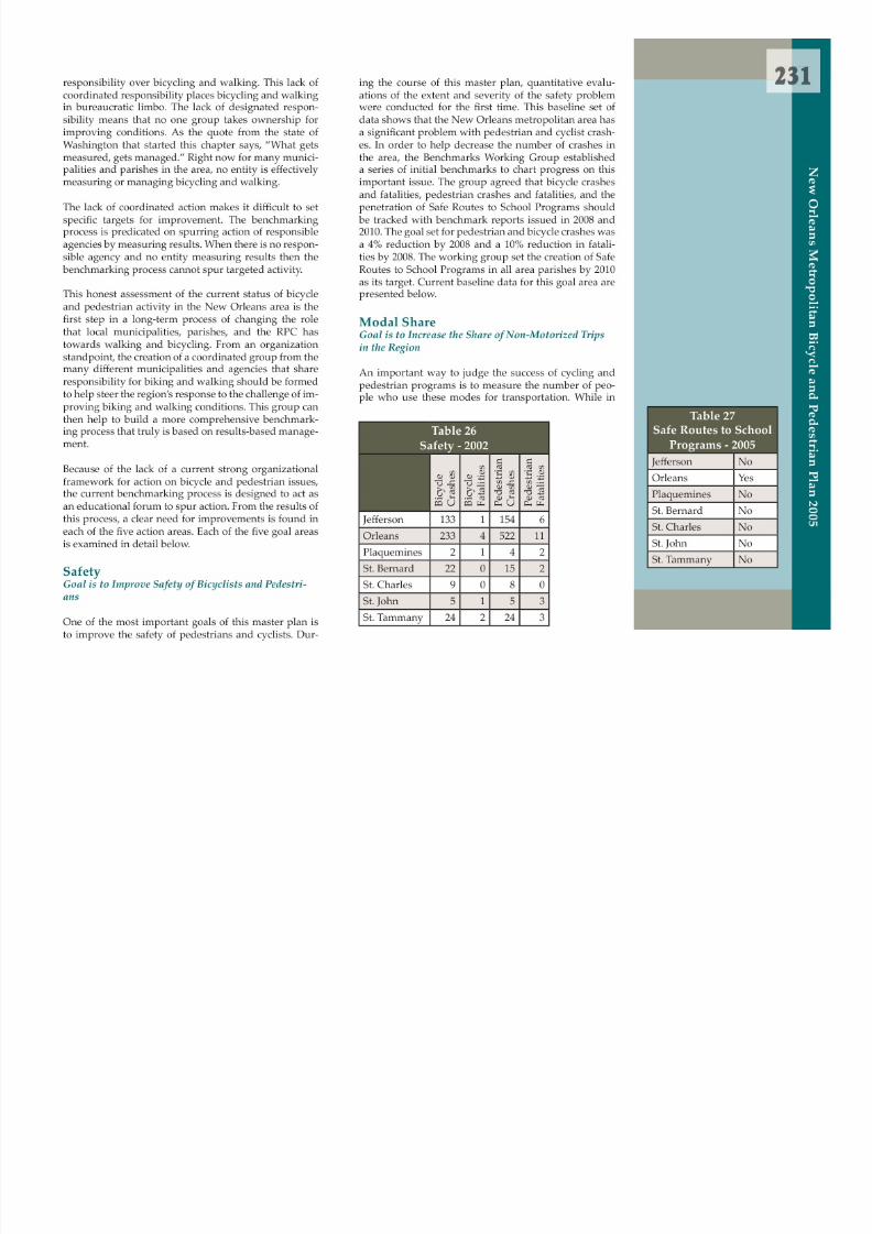
8/6/2019 2005 New Orleans Metropolitan Bicycle and Pedestrian Plan
http://slidepdf.com/reader/full/2005-new-orleans-metropolitan-bicycle-and-pedestrian-plan 238/249
2 the future it may be possible to create a direct trackingprogram to count pedestrians and cyclists directly incertain areas, the only current source of data for modeshare is the US Census count for pedestrian and bicy-clist commuters. The working group did not set speci cnumeric targets for increasing the mode share of theseindicators, but current low levels suggest that there is agreat deal of room for improvement. Current baseline
data for these indicators is presented below.
Tab le 28Modal Share - 2000
B i c y c l e
C o m m u n
t e r s
P e d e s t r i a n
C o m m u
t e r s
T o t a l
B i c y c l e % o f
T o t a l
P e d e s t r i a n
%
o f T o t a l
Jefferson 679 3,654 209,611 0.32 1.74Orleans 2,187 9,822 188,703 1.16 5.21Plaquemines 78 222 10,074 0.77 2.20St. Bernard 100 396 28,739 0.35 1.38St. Charles 44 298 21,134 0.21 1.41St. John 27 256 17,466 0.15 1.47o l i t a n
B i c y c l e a n d
P e d e s t r i a n P l a n 2 0 0 5
Tab le 29Facilities - 2005
Miles of ExistingOn-Street Bicycle
Lanes
Miles of ExistingOn-Street
Bicycling Routes
Jefferson 0 not calculated
Orleans 0 1Plaquemines 0 not calculatedSt. Bernard 0 not calculatedSt. Charles 0 not calculatedSt. John 0 not calculatedSt. Tammany 0 not calculatedRegional 0 1
Tab le 30Facilities - 2005
Miles of ExistingOff-Street Shared-
Use Paths
Jefferson 30

8/6/2019 2005 New Orleans Metropolitan Bicycle and Pedestrian Plan
http://slidepdf.com/reader/full/2005-new-orleans-metropolitan-bicycle-and-pedestrian-plan 239/249
Facilities Goal is to Create a Complete Pedestrian and Bicycling Network for the Region
Another important way to judge the success of cyclingand pedestrian programs is to measure the extent ofdedicated facilities that are present in our communities.
The working group agreed that the number of milesof bicycle routes, lanes, and o ff-road, dedicated pathsshould be tracked. In addition, the number of bicycleparking places and the number of passengers utilizing
bike-on-bus services of area transit providers are also to be tracked.
Targets were set for transit ridership in Je fferson and St.Tammany parishes. In St. Tammany, the target was 1%of all trips taken by transit by 2010 and 2.5% by 2020 (St.Tammany currently has very limited transit service). In
Jefferson, the target for transit ridership was 3% by 2010and 4% by 2020. No other target levels for the other in-dicators were set.
St. Tammany 221 716 87,130 0.25 0.82
N e w
O r l e a n s
M e t r o p o
Orleans 7
Plaquemines 0St. Bernard 0St. Charles 7.9St. John 0.8St. Tammany 31Regional 76.7

8/6/2019 2005 New Orleans Metropolitan Bicycle and Pedestrian Plan
http://slidepdf.com/reader/full/2005-new-orleans-metropolitan-bicycle-and-pedestrian-plan 240/249

8/6/2019 2005 New Orleans Metropolitan Bicycle and Pedestrian Plan
http://slidepdf.com/reader/full/2005-new-orleans-metropolitan-bicycle-and-pedestrian-plan 241/249
Pu b lic and Pri vate Sector Roles

8/6/2019 2005 New Orleans Metropolitan Bicycle and Pedestrian Plan
http://slidepdf.com/reader/full/2005-new-orleans-metropolitan-bicycle-and-pedestrian-plan 242/249

8/6/2019 2005 New Orleans Metropolitan Bicycle and Pedestrian Plan
http://slidepdf.com/reader/full/2005-new-orleans-metropolitan-bicycle-and-pedestrian-plan 243/249

8/6/2019 2005 New Orleans Metropolitan Bicycle and Pedestrian Plan
http://slidepdf.com/reader/full/2005-new-orleans-metropolitan-bicycle-and-pedestrian-plan 244/249
2
p o l i t a n B i c y c l e a n
d P e d e s t r i a n P l a n 2 0 0 5
Technical
State
Continue to collect crash data statewidefrom local police departments
Disseminate data to each Metropolitan Plan-ning Organization in the state
Analyze crash data for trends and strategictargets for improvement for bike and pedes-trians
Review state bike map against proposedmaintenance and capacity projects; Coordi-nate all design and construction work withdesired bike friendly treatments includingshoulder widening, clear intersection andpavement markings, and bike route sig-
nage.Prevent unfriendly designs such as shoulderrumble strips and inconsistency of bike fa-cilities in favored bike corridors.
Regional
Set regional benchmarks and evaluate prog-ress
Local
Develop bicycle and pedestrian design crite-ria for local streets in your parish or munici-pality
Improve police data collection of crash loca-tions (particularly rural) and overall report-ing procedures
Develop an on-street bicycle network planin each parish and jurisdiction
Implement state education guidelines for bike and pedestrian safety education inschools
Provide a venue for pedestrian and bicycleadvocates into the public planning process
Retro t streets identi ed in the on-street bi-cycle network plan
Retro t all sidewalks and crosswalks identi- ed in the pedestrian plan
Continue the extension of o ff-street bicyclepaths on river levees and lakefront and oth-er off-street corridors
Coordinate all parish or municipal depart-ments to align with the goal of a t aining a bi l d d i k

8/6/2019 2005 New Orleans Metropolitan Bicycle and Pedestrian Plan
http://slidepdf.com/reader/full/2005-new-orleans-metropolitan-bicycle-and-pedestrian-plan 245/249
N e w
O r l e a n s
M e t r op Analyze bike and pedestrian crash data for
hot spots
Analyze bike and pedestrian crash data inrelation to transit routes, poverty, schools,and age
Disseminate ndings to parish and local ju-risdictions
Begin latent demand analysis in targeted ar-eas or corridors
Provide a venue for pedestrian and bicycleadvocates into the public planning process
Support parish and local planning agenciesanalysis of transportation systems, intersec-tions, and corridors for bike and pedestriansafety and convenience
rst rate bicycle and pedestrian network(street cleaning, street repair, design and en-gineering, planning, adult and child behav-iors)
Regulatory
State
Initiate a statewide advisory commi t ee to evalu-ate all state laws pertaining to bicycle and pedes-trian use
Compare ndings to other progressive statelaws
Recommend appropriate modi cations, penal-ties, additions, deletions
Adopt changes into state law
8/6/2019 2005 New Orleans Metropolitan Bicycle and Pedestrian Plan
http://slidepdf.com/reader/full/2005-new-orleans-metropolitan-bicycle-and-pedestrian-plan 246/249

8/6/2019 2005 New Orleans Metropolitan Bicycle and Pedestrian Plan
http://slidepdf.com/reader/full/2005-new-orleans-metropolitan-bicycle-and-pedestrian-plan 247/249

8/6/2019 2005 New Orleans Metropolitan Bicycle and Pedestrian Plan
http://slidepdf.com/reader/full/2005-new-orleans-metropolitan-bicycle-and-pedestrian-plan 248/249
2
ro p o l i t a n
B i c y c l e a n
d P e d e s t r i a n P l a n 2 0 0 5
more encouraging place for cyclists and pedestrians.These policies and actions are not experimental or nov-el. They have been successfully implemented in citiesaround the nation. Clear progress in safety, health, andlivability has been noted in communities around thecountry that have implemented these changes.
This master plan represents the rst a t empt to integratepedestrian and bicycling issues into the mainstream oflocal transportation policy. The planning process has
built organizational relationships and widened the un-derstanding of the importance of bicycling and walk-ing issues in the community. While this is certainly asigni cant accomplishment considering the low level ofawareness that walking and biking have traditionallyreceived in the New Orleans region, this should only
be seen as the rst step in a long-term transition pro-cess. One of the signi cant steps that remains ahead of
us is the formation of a speci c template for detailed,accountable actions to be undertaken by the di fferinglayers of the public bureaucracy. While the plan high-lights numerous e ffective policies that can be taken bymunicipalities, parishes, and state agencies that a ffectwalking and bicycling conditions, it does not providea clear organizational framework for detailed actions.To help build on the momentum established during thisplanning process, it is vital for the public sector to begint b ild i i ti l t bilit f bi

8/6/2019 2005 New Orleans Metropolitan Bicycle and Pedestrian Plan
http://slidepdf.com/reader/full/2005-new-orleans-metropolitan-bicycle-and-pedestrian-plan 249/249
N e w
O r l e a n s
M e t r o to build speci c organizational accountability for bicy-
cling and walking policy. This step requires hard workand concerted action.