METALLOGENY IN SARDINIA (ITALY): FROM THE CAMBRIAN TO … · METALLOGENY IN SARDINIA (ITALY): FROM...
44
Florence - Italy August 20-28, 2004 Post-Congress 32 nd INTERNATIONAL GEOLOGICAL CONGRESS Volume n° 4 - from P14 to P36 Field Trip Guide Book - P30 P30 METALLOGENY IN SARDINIA (ITALY): FROM THE CAMBRIAN TO THE TERTIARY Leaders: A. Marcello, S. Pretti, P. Valera Associate Leaders: M. Agus, M. Boni, M. Fiori
Transcript of METALLOGENY IN SARDINIA (ITALY): FROM THE CAMBRIAN TO … · METALLOGENY IN SARDINIA (ITALY): FROM...

Florence - ItalyAugust 20-28, 2004 Post-Congress
32nd INTERNATIONAL GEOLOGICAL CONGRESS
Volume n° 4 - from P14 to P36
Fie
ld T
rip
Gu
ide B
oo
k -
P3
0
P30
METALLOGENY IN SARDINIA (ITALY): FROM THE CAMBRIAN TO THE TERTIARY
Leaders: A. Marcello, S. Pretti, P. Valera
Associate Leaders: M. Agus, M. Boni, M. Fiori
P30_copertina_R_OK C 21-06-2004, 9:34:57

The scientific content of this guide is under the total responsibility of the Authors
Published by: APAT – Italian Agency for the Environmental Protection and Technical Services - Via Vitaliano Brancati, 48 - 00144 Roma - Italy
Series Editors:Luca Guerrieri, Irene Rischia and Leonello Serva (APAT, Roma)
English Desk-copy Editors:Paul Mazza (Università di Firenze), Jessica Ann Thonn (Università di Firenze), Nathalie Marléne Adams (Università di Firenze), Miriam Friedman (Università di Firenze), Kate Eadie (Freelance indipendent professional)
Field Trip Committee: Leonello Serva (APAT, Roma), Alessandro Michetti (Università dell’Insubria, Como), Giulio Pavia (Università di Torino), Raffaele Pignone (Servizio Geologico Regione Emilia-Romagna, Bologna) and Riccardo Polino (CNR, Torino)
Acknowledgments:The 32nd IGC Organizing Committee is grateful to Roberto Pompili and Elisa Brustia (APAT, Roma) for their collaboration in editing.
Graphic project:Full snc - Firenze
Layout and press:Lito Terrazzi srl - Firenze
P30_copertina_R_OK D 25-05-2004, 16:37:54

Florence - ItalyAugust 20-28, 2004
32nd INTERNATIONAL GEOLOGICAL CONGRESS
Volume n° 4 - from P14 to P36
P30
AUTHORS: A. Marcello¹, S. Pretti¹, P. Valera¹, M. Agus³, M. Boni², M. Fiori³1 Dipartimento di Geoingegneria e Tecnologie Ambientali, Università di Cagliari - Italy2 Dipartimento di Geofi sica e Vulcanologia, Università “Federico II” di Napoli - Italy3 Istituto di Geologia e Geoingegneria Ambientale del C.N.R., Sezione di Cagliari - Italy
METALLOGENY IN SARDINIA (ITALY): FROM THE CAMBRIAN
TO THE TERTIARY
Post-Congress
P30_R_OK A 21-06-2004, 9:37:00

Front Cover: the southwestern coast of Sardinia.
P30_R_OK B 25-05-2004, 16:47:35

METALLOGENY IN SARDINIA (ITALY): FROM THE CAMBRIAN TO THE TERTIARY P
30
3 - P30
Vo
lum
e n
° 4
- f
rom
P1
4 t
o P
36
IntroductionIn spite of its relatively small surface (24,090 km2), the island of Sardinia was one of the most important mining regions in Europe. For this reason it has always called the attention of miners and geologists. The general metallogenic outline of Sardinia, its consequent distribution of ores and industrial minerals, and their controlling factors will be given a brief overview in this initial section, in order to provide the readers with the main elements of Sardinian metallogeny.
Regional geologic settingThe Sardinia-Corsica Massif is a microplate that has had a very long geological history (Oggiano et al., 2001). In Sardinia the sedimentary, magmatic, and metamorphic records, over a time span that includes the entire Phanerozoic, are well represented within three main lithologic complexes:
• a mainly Palaeozoic basement that underwent repeated phases of deformation and metamorphism during the Caledonian and Hercynian orogenic cycles, and was eventually intruded extensively by calc-alkaline granitoids;• a Late Palaeozoic epicontinental sequence and a Mesozoic carbonate platform sequence, representative of stable shelves, that bounded the passive margin of Southern Europe;• a Cainozoic to Quaternary volcanic and sedimentary cover consisting of shallow-water marine carbonates, siliciclastic sediments, continental conglomerates, as well as volcanic rocks represented by a calc-alkaline suite, and by within-plate basalts.
The basement of Sardinia is a segment of the South Variscan chain which, after the Cainozoic drifting of the island, shows a NW-SE trend and crops out with good continuity. From south to north its structural framework includes the following three different zones:I) a thrust-and-fold belt foreland consisting of a sedimentary succession ranging in age from Upper Vendian to Lower Carboniferous, which crops out in the SW of the island (External Zone);II) a SW-verging nappe building that equilibrated under greenschist facies conditions and occupies the centre of the island. It consists of a Palaeozoic metasedimentary succession hosting a thick
continental arc-related volcanic suite (Nappe Zone);III) an inner zone that includes a high-grade metamorphic complex juxtaposed to a medium-grade one along a mylonitic belt (Internal Zone), located at the north-eastern side.The stratigraphically lowermost sequence (Carmignani et al., 1994), which occurs in SW Sardinia (Iglesiente-Sulcis region), is probably of Pre-Cambrian age and consists mainly of terrigenous metasediments represented by feldspathic metasandstones, quartzites, metaconglomerates, and thin dolomitic intercalations that grade upwards into shales, metasiltites, and metasandstones (Bithia Formation). The overlying Nebida Formation, the oldest fossiliferous terrain, mostly consists of terrigenous metasediments with minor oolitic limestones bearing Early Cambrian Archaeocyathas, Trilobites and algal stromatolites, and is believed to represent a continental shelf environment with eastward prograding deltaic systems (Matoppa Member) that evolved into an oolitic lagoonal environment. This terrigenous formation grades upwards into a thick carbonate sequence consisting of dolostones and limestones (the Gonnesa Formation), which represent an arid tidal fl at system. The “drowning” of this carbonate platform marks the beginning of the Cabitza Formation, and is recorded by the occurrence of nodular limestones (“Calcescisti” Auctt.) rich in Middle Cambrian trilobites, echinoderms, and brachiopods. The overlying deeper-environment member consists of a 400-m thick neritic terrigenous succession in which the youngest levels contain achritarcs and graptolites (Dictyonerna fl abelliforme) of Tremadocian age (“Argilloscisti di Cabitza”, Auctt). These lagoonal and epicontinental carbonate and terrigenous deposits correspond to thick siliciclastic sequences in the Nappe Zone (the San Vito and Solanas Formations).All over Central and SE Sardinia, Middle Cambrian-Early Ordovician metasedimentary sequences are overlain by an Arenigian-Caradocian metavolcanic complex, which includes several effusive episodes, with abundant pyroclastic fl ows, and intrusions into the basement. The magmatic products include a complete sub-alkaline suite ranging in composition from basaltic-andesitic to rhyolitic, with acid terms being more abundant than the intermediate and basic ones. These characters are typical of an orogenic suite involving continental crust. Extensive evidence supports the hypothesis of a magmatic arc
Leader: A. Marcello, S. Pretti, P. ValeraAssociate Leaders: M. Agus, M. Boni, M. Fiori
P30_R_OK 3 25-05-2004, 16:47:47

Vo
lum
e n
° 4
- f
rom
P1
4 t
o P
36
P30 - 4
Leaders: A. Marcello, S. Pretti, P. Valera
P3
0
Figure 1 - Geological sketch map of Sardinia
P30_R_OK 4 27-05-2004, 14:22:56

METALLOGENY IN SARDINIA (ITALY): FROM THE CAMBRIAN TO THE TERTIARY P
30
5 - P30
Vo
lum
e n
° 4
- f
rom
P1
4 t
o P
36
connected to a subduction of the oceanic lithosphere under the northern Gondwanian margin. The arc-trench gap was incorporated in the Internal Nappes (Mount Gennargentu, Baronie region). The back-arc basin in the Iglesiente-Sulcis region is devoid of calc-alkaline magmatism and underwent an Early Hercynian compressional event. This post-Tremadoc and pre-Caradoc phase of deformation, which is found in many parts of Europe, is very evident here, especially in the Iglesiente region, where the Cambrian-Lower Ordovician sequences were folded before the Caradocian (“Sardinian Unconformity”). The products of the subsequent erosion reaches up to several hundreds of metres in thickness (“Puddinga” Auctt.). This angular unconformity has also been reported in south-eastern (Sarrabus-Gerrei region) and central Sardinia, where the Cambrian-Lower Ordovician successions are often separated from the Middle- to Upper-Ordovician volcanics and sediments by conglomerates mainly derived from the volcanic arc.Both the “Puddinga” continental clastics and the Middle-Ordovician metavolcanics of central and south-eastern Sardinia are covered by terrigenous continental to littoral sediments that show a large variability in thickness and facies “Caradocian Transgression”) and are interbedded with alkalibasaltic metavolcanics. The transgressive Late Ordovician deposits grade upwards to neritic clay and carbonate deposits (“Ashgillian Limestones”) followed by uniform deposits of Silurian black shales and cherts. The magmatic quiescence, combined with the sedimentary evolution to a pelagic-type deposition indicates that, at least in this time span, the Gondwanian continental edge behaved as a subsiding passive continental margin. On this margin Silurian black shales, which occur everywhere, grade upwards into Lower- and Middle-Devonian pelagic marly shales and nodular Tentaculite-bearing limestones, and then Lower Carboniferous (Tournaisian) thick pelagic limestones, locally replaced, in a few internal areas (Nurra, Baronie) by thick terrigenous sequences. In the outermost platforms the carbonate sedimentation was suddenly interrupted and changed to Culm-type syn-orogenic deposits.The above structural framework and the related stratigraphical evolution mainly show the effects of the Hercynian Orogeny, superimposed upon those of the Caledonian, which occur in the oldest terrains (especially the “Sardinian Phase”).The main tectonic phases of the Hercynian Orogeny are: the stacking of the Gondwanian continental
margin, and the gravitational collapse of the collisional orogenic wedge.The Hercynian collisional event is well preserved in the Sardinian basement. The overthrusting continental margin is represented by the “High Grade Metamorphic Complex” (Internal Zone) of northern Sardinia and Corsica; the underthrust continental margin is represented by the Internal (Nappe Zone) and External (External Zone) Nappe Complexes of central and southern Sardinia. The two domains are separated by the “Posada-Asinara Line” suture zone. The External Zone Complex, cropping out in the Iglesiente-Sulcis region, is a classic fold-thrust belt characterised by medium- to steeply-dipping thrusts, fold axial planes and cleavages, and very low-grade Hercynian metamorphism. For the late stages of the Hercynian collision or early uplift, an age of 344 Ma has been proposed.An important extensional event also developed in the Sardinian Variscides as a response to gravitational re-equilibration within the collisional structure. The extensional evolution is confi ned to a time interval extending from the end of the collision to the emplacement of the widespread calc-alkaline plutonism of the Sardinian-Corsican batholith, and to the development of the largely coeval Stephanian-Autunian basins.After the end of the Palaeozoic and up to the Messinian, the Sardinian-Corsican Massif was affected by a number of movements that account both for its present position and for the evolution of the Western Mediterranean.During the Late Palaeozoic, Sardinia and Corsica were involved not only in the last Hercynian collapses, but also in horizontal translations along the North Pyrenean transcurrent fault, roughly off Provence. A long continental period began, and in Sardinia it was characterised by structural highs and lows; a wide peneplanation was reached. During the Mesozoic extensive movements occurred. At that time the western margin of the Massif (together with its adjacent north-western areas) bordered on wide platforms and shallow, narrow intracratonic basins eastwards. In these basins Germanic F[acies sediments were being deposited. The eastern margin of the Massif represented the western border of the Triassic Alpine Basin.A transgression started in the Triassic, and gradually extended during the Jurassic] towards the eastern part of the Massif. On this platform a Provençal Facies carbonatic complex was deposited. Confi ned pelagic episodes also attest to synsedimentary extensive
P30_R_OK 5 25-05-2004, 16:48:15

Vo
lum
e n
° 4
- f
rom
P1
4 t
o P
36
P30 - 6
Leaders: A. Marcello, S. Pretti, P. Valera
P3
0
tectonics, as an early sign of the opening of the Ligurian-Piedmontese oceanic basin. The tearing of the sialic crust during the Upper Jurassic separated the Sardinian-Corsican Massif from the Tuscan one. As a matter of fact an oceanic basin opened with simatic crust (ophiolites) and pelagic sediments, which evolved to fl ysch in the Upper Cretaceous. The Sardinian-Corsican Massif has continued evolving together with the stable side of the European plate up to present, while eastwards the Tuscan basement followed the new evolution phenomena of the Apennine continental margin. This is consistent with the Cretaceous carbonatic platform sediments occurring in Sardinia. Nearly at the end of the Cretaceous, the closure of the Ligurian-Piedmontese basin commenced and the African continent again approached the European. The collision occurred during the Middle Eocene. However, clear evidence of compressive phenomena related to this event is lacking in Sardinia. On the contrary, its post-Hercynian evolution seems to be characterised by extension structures, which developed during the Upper Eocene, and in the Lower Miocene caused the separation of the Massif from stable Europe. During the Oligocene continental conditions prevailed, and an intense calc-alkaline magmatic activity (Coulon et al., 1977), related to the beginning of a counter-clockwise rotation of the Massif, developed in Sardinia, and left important volcanic massifs in the western half of the island. During the Miocene some Sardinian structural lows (“Sardinian Rift”) were covered by epicontinental seas, others formed lagoonal or lacustrine basins (Cherchi et al., 1982). This sea separated two emerged areas, south-west and north-east relative to the rift. This transgression is related with the opening of the Algerian-Provençal basin, and is characterised by mainly terrigenous deposition, whose products cover a N-S belt all along the island.In the Upper Miocene almost the whole of Sardinia emerged again, leaving only a few, marginal lagoonal areas. At that time the counter-clockwise rotation stopped, and an alkaline magmatism followed. In the Quaternary continental conditions were maintained. Sea level variations related to glacial cycles are attested to by Tyrrhenian fossiliferous sediments (“Panchina”). The fi lling of the lagoonal basins continued, and today a few lagoons still exist, mainly at the extremities of the Campidano plain. The alkaline volcanic activity also ceased in the Pleistocene, leaving cinder cones and basalt fl ows.As to the currently seen metallogenic outline of
Sardinia (Marcello et al., 1994), it is believed to include seven metallogenic periods, which occurred at different moments of the above depicted geological evolution of the island. [? this isn’t clear: it’s different from described above. The island is depicted above? It’s obvious what island they’re talking about…] At places these periods interacted, so that the present shape, grade, and composition of many Sardinian deposits are the fi nal result of subsequent reworkings of depositions that were not always economic originally.The fi rst metallogenic period affected the Cambrian complex of SW Sardinia. It yielded different ore/mineral accumulations according to the different palaeo-geographic conditions that occurred during the sedimentation and diagenesis of the middle formation of the Cambrian series (i.e. the Gonnesa Fm, a carbonate platform some hundred metres thick, also called “Metalliferous Limestone”), as well as during the transition zones both to the underlying sandy-silty formation and to the overlying silty-shaly formation.From the lower to the upper section of the sequence, these deposits include:(i) residual Fe-ox. scanty accumulations;(II) BaSO
4 evaporitic bodies, at
places of some economic interest;(III) important volcano-sedimentary massive accumulations of FeS
2-ZnS with occasional PbS;(IV)
synsedimentary (possibly volcano-sedimentary) low-grade stratabound depositions of disseminated ZnS-FeS
2 with occasional PbS (the so-called “Blendous
Limestone);(V) similar depositions of PbS-ZnS with minor amounts of FeS
2.
The entire Cambrian carbonate member displays a positive geochemical anomaly for Ba (local values also exceed 1000 ppm), Pb and Zn (20-100 ppm).The depositions described under (IV) and (V) were often subeconomic, but several important ore-bodies were generated through subsequent metallogenic events after these protores.The second metallogenic period is related to the Early Hercynian (Sardinian Phase) folding that took place in the Early Ordovician; erosion and leaching of the emerged “Metalliferous Limestone” yielded locally economically-feasible deposits of BaSO
4 pebbles in the basal conglomerate
of the overlying Arenig, and karstic accumulations in the same limestone of PbS, PbS + ZnS, very pure Fe
2O
3, BaSO
4, and CaF
2.The third metallogenic
period took place from the Middle Ordovician to the Early Devonian and yielded four different types of deposits. Many of these have a synsedimentary character, at least as far as regards their protores; others may be regarded as volcano-sedimentary or decidedly volcanogenic, and may be grouped as
P30_R_OK 6 25-05-2004, 16:48:18

METALLOGENY IN SARDINIA (ITALY): FROM THE CAMBRIAN TO THE TERTIARY P
30
7 - P30
Vo
lum
e n
° 4
- f
rom
P1
4 t
o P
36
follows: (i) a number of generally small, high-grade, mixed-sulphide lenses, scattered in the Silurian black shales of the entire island; they show evident sedimentary features (load cast, slumping, diagenetic fracturing). These deposits are quite similar to the Meggen and Rammelsberg (Central Germany) deposits, although of far smaller size (not exceeding a few hundred thousand tons);(II) stratabound antimonite-scheelite concentrations, often with interesting gold contents, hosted in a volcano-sedimentary sequence outcropping in the SE corner of the island (Sarcidano, Gerrei, and Sarrabus Regions). A connection with coeval volcanics seems much more evident in this case. The ore-bearing formation could be considered an extension to Sardinia of the well known Middle Palaeozoic horizon, hosting the strata- and time-bound Sb, Hg, W, and As deposits, and running all along the Alpine Chain and the Southern Appennines (Calabria, Monti Peloritani);(III) gold occurrences, geographically close to those of the above group (at least as known so far), associated with metavolcanics. Although gold anomalies have been known for some time, only very recently a veritablegold deposit has been discovered and is currently under exploration;(IV) oolitic iron ore accumulations interbedded in Silurian slates in close connection with a mafi c laccolith. These deposits occur in the NW corner of the island (the Nurra Region).The fourth metallogenic period is related to Hercynian Orogeny metamorphism and magmatism. It had strong effects both as a promoter of the remoulding of pre-existing ore/mineral concentrations (by tectonic effects and/or by post-magmatic fl uid circulation) and as a source of new ore and industrial minerals. The types of deposits formed during this period are as follows (in decreasing order of economic interest):(i) hydrothermal base-metal and industrial-mineral veins, some of which were among the most important mining reserves of Sardinia. A prominent example is Montevecchio-Ingurtosu, a vein system with a total tonnage of about 50-60 M tons of crude ore at 10-11 % combined Pb+Zn, 500-1000 g Ag per ton of Pb, and 1000 g of Cd per ton of Zn.Another very important example is the fl uorite-barite-galena deposit of Silius, whose original reserves included 30 M tons of CaF
2,
15 M tons of BaSO4, and 1.5 M tons of Pb).One
particular vein system is characterised by its richness in Ag, at places with recoverable quantities of galena, and minor sphalerite. This type is only known in SE Sardinia (Sarrabus Region), and is assumed to be a reconcentration of a previous stratabound deposition
of the third period;(II) skarn deposits, generated by contact metamorphism of previous protores and/or metasomatic replacement. In such bodies pyrite, pyrrhotite, hematite, and magnetite are frequent, while other ore minerals (mostly sulphides) were mobilized and driven away to various extents. Iron ore deposits, generally depleted in sulphides, may thus have been generated. San Leone (Sulcis) is the most important example of this (20-25 M tons at 40-45 wt% Fe practically exhausted). CaWO
4 and fl uorite
also occur commonly in these skarns;(III) greisen typeoccurrences; the ore composition includes, in decreasing order of frequency: molybdenite, chalcopyrite, wolframite, pyrite, cassiterite; recent studies also showed the presence of gold in one of theseoccurrences;(IV) talc-chlorite and albite occurrences related with metasomatic-hydrothermal phenomena following the emplacement of granite batholiths; the economically-feasible occurrences, in central Sardinia, include about 6 M tons of talc-chlorite and at least 25 M tons of albitite;(V) pegmatite dykes and pegmatitic granite. These facies and their erosion/alteration products are exploitable and partially exploited for K-feldspar, quartz, and, when kaolinized as raw materials for pottery;(VI) high-thermality veins, carrying W, Mo, As, Ni, Co, and V. Although numerous around the granites of SW Sardinia, these veins do not reach an overall tonnage suffi cient for economic exploitation;(VII) porphyry type Mo occurrences. Although a few vein-type concentrations were explored and partially exploited in the past (especially during the last World War), no serious studies have ever been carried out on any of these occurrences as such.The correlation between type of deposit and type of granite is not always obvious. A “preference” of most types of deposits for I-type granites, and particularly of hydrothermal deposits for leucogranites, is commonly accepted.The fi fth metallogenic period is related to the post-Hercynian peneplanation. Supergenic phenomena caused alterations and mobilisations of pre-existing ore/mineral concentrations, and yielded: (I) residual concentrations of iron ores, at present sub-economic, and/or deposition of kaolin and fi reclays, lying on the post-Hercynian peneplain. The latter are considerable where preserved by Mesozoic-Cainozoic covers, and the fi reclays are currently being exploited;(II) karstic concentrations of BaSO
4,
P30_R_OK 7 25-05-2004, 16:48:19

Vo
lum
e n
° 4
- f
rom
P1
4 t
o P
36
P30 - 8
Leaders: A. Marcello, S. Pretti, P. Valera
P3
0
and oxidised Pb-Zn-Fe ores[?]; (III) intensive supergene reworking of the pre-existing ore/mineral accumulations; this phenomenon is particularly evident in the Pb-Zn-Ag deposits of Iglesiente; (IV) deposition of high-purity quartz conglomerates, in some instances (Central Sardinia) interdigitated with the kaolin-fi reclay accumulations mentioned above (point (I)).The post-Hercynian erosion started in the Carboniferous-Permian: in fact, the fi rst post-Hercynian discordant sediments are of this age. The fi rst metallogenic effect of this phase has been recognised in some mineralised karst fi llings in the folded Cambrian limestone and fossilised by post-Hercynian (probably Triassic) sediments.Upheaval and erosion of the Hercynian chain continued up to the present, almost incessantly in some areas, as is shown by the fact that some ore-bearing karst systems include both pre-Triassic fossilised deposits and columnar bodies whose vertical extent is controlled by the present position of the water table.The sixth metallogenic period took place in the Middle Cretaceous and yielded rather conspicuous bauxite deposits along an emersion surface of the Mesozoic carbonate platform of Nurra. The recently explored deposit of Olmedo (proven plus inferred reserves: 30-35 M tons at 60-62 wt% Al
2O
3; total reserves possibly
up to 70-80 M tons) is the best example of this. It is to be pointed out that bauxite accumulation during the Mesozoic carbonate platform evolution involved the entire Mediterranean area, both on the European and the African plates.The seventh and last metallogenic period is related to the Alpidic tectonic and magmatic activity.Since the Alpidic tectonics only gave extensive phenomena in Sardinia, its effects on pre-existing ore occurrences are mainly displacements without important mobilisation, as was the case [in contrast to H. orogeny?]of Hercynian orogeny, with the exception of those due to local uplifts as said above.It is the related Oligocene-Miocene calc-alkaline magmatism that produced minerogenetic phenomena, whose importance is just now being recognised.The main ore occurrence types are the following:(i) porphyry copper (-gold) deposits, linked to subvolcanic bodies at Calabona, close to Alghero (Frezzotti et al., 1992), Siliqua (Maccioni et al., 1992; Fiori et al., 2003) in Eastern Iglesiente, and in other areas now under investigation;(II) ochers and/or Mn ores linked with effusive activity (the island of San Pietro, and north-western Sardinia). At places supergene enrichment played an important role in the formation of Mn
accumulations, yielding thin crusts of highly- pure Mn oxides;(III) precious and base metal occurrences in epithermal systems. These systems have been found very recently and are now being actively investigated and exploited. Both low- and-high-sulphidation occurrences have been found so far. Their economic worth appears so interesting that the low-sulphidation bodies of Furtei are currently being mined, and a few tons of gold have already been recovered only in the oxidised part of the explored bodies;(IV) kaolins and bentonites (Palomba et al., 2003) after hydrothermal and/or supergenic alteration of the same volcanics[which same volcanics?];(V) Cu-Pb-Zn oxidized and sulphide minerals in clastic, at times barite-cemented, beds, at the base of the Miocene sediments, following erosion of the volcanogenic deposits (Fadda et al., 1998). Their importance has not yet been established.The last product of the phenomena mentioned above is the residual BaSO
4
accumulations (either as pebbles or veinlets) in Quaternary eluvial soils, close to the ouctrops of barite occurrences hosted in the underlying Palaeozoic of Iglesiente. In one of these occurrences, which covered karst fi llings and was exploited with them, obsidian splinters deriving from prehistoric industry are mixed in with the barite clasts.(VI) Geothermal systems and thermal waters, related to the Tertiary volcanic cycle, and still active in some districts. Studies on geothermal energy exploitation have not reached the operational level yet, while a thermal establishment has long been in operation and others will begin to operate soon; several occurrences zeolitised pyroclastics are scattered all over the areas covered by Tertiary volcanics. Studies on their industrial uses are still in progress.For completeness’ sake, it should be mentioned that two types of fossil coal are also found in Sardinia: anthracite (one small occurrence no longer exploited) below Permian terrains, and sub-bituminous coal (a huge deposit) in the Lower Eocene.
Field trip itinerary
DAY 1Itinerary: Cagliari, Furtei, Barumini
On the fi rst day we shall leave from Cagliari and drive along the SS 131 “Carlo Felice” main motorway, which crosses the island on the west from south to north. After about 20 km we reach the fi rst group of volcanic hills that border the Campidano plain on the east. We drive for another 10 km and reach the site of the Furtei gold mine.
P30_R_OK 8 25-05-2004, 16:48:21
METALLOGENY IN SARDINIA (ITALY): FROM THE CAMBRIAN TO THE TERTIARY P
30
9 - P30
Vo
lum
e n
° 4
- f
rom
P1
4 t
o P
36
Stop 1: Furtei gold mineThe Furtei gold mining site is located in the Campidano Graben, a tectonic structure that extends for about 100 km in a NW-SE direction from the Gulf of Oristano to the Gulf of Cagliari. At Furtei, as at other signifi cant epithermal gold-silver mineralizations in Europe, an Au-Cu-Ag high-sulphidation deposit is associated with calc-alkaline volcanics of the Oligo-Miocene cycle (seventh metallogenic period).After the discovery of a hydrothermal alteration and strong gold anomalies in this area by a Cagliari University-CNR team (Fiori et al., 1988, Fiori et al., 2003), a fi rst exploration campaign (1988-1993) was carried out by a joint Progemisa-SIM venture. During this campaign the mineralised bodies of Monte Santu Miali, Is Concas, and Sa Perrima were explored. In 1994 a new joint venture was established between Progemisa and Gold Mines of Sardinia. Subsequent exploration programs concentrated on targets around the main ore bodies and expanded the mining resources of the area. From the beginning of mining activity in mid 1997 up to mid 2003, Furtei produced about 32M oz gold and 159,000 oz silver, for an overall value of about $33M. The published resource is 6.2 Mt at 2.7 g/t gold, mostly relating to the oxidised upper parts of the explored bodies.
GeologyThe gold mineralisation is hosted in an Oligocene-Miocene volcano-sedimentary sequence, unconformably overlying metasandstones,metapelites, and quartzites of the Palaeozoic basement and an Eocene sedimentary unit.The complex, from the oldest to the youngest unit includes:• horneblende porphyry andesite domes;• a volcanoclastic unit, consisting of siltstones, sand-
stones, conglomerates, and ash deposits;• a diatreme breccia, which hosts the main Au-Cu ore
bodies. The breccia is polygenic and heterometric and contains clasts and fragments of andesite, and from the volcanoclastic unit and the Palaeozoic basement;
• a tuff apron breccia, containing andesitic blocks and ash deposits, which is overlain by ignimbrite. It
forms the ring surrounding the diatreme.The Furtei volcanic complex is partially overlain by marine Miocene sedimentary deposits and a Pliocene-Pleistocene sequence including conglomerates, sandstones, limestones, and marls.The hydrothermal activity is bracketed in the narrow time span between the eruption of Upper Oligocene volcanic products that host the mineralisation, and the deposition of Lower Miocene sandy marls unaffected by hydrothermal alteration.
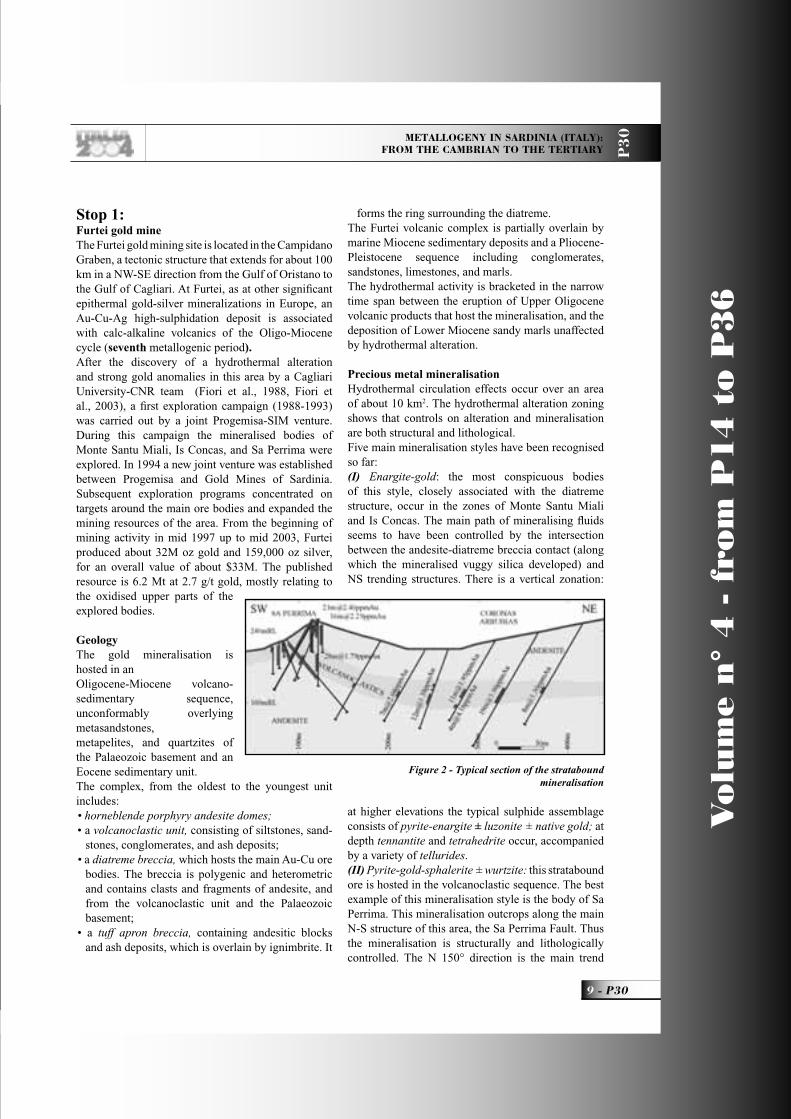
Precious metal mineralisationHydrothermal circulation effects occur over an area of about 10 km2. The hydrothermal alteration zoning shows that controls on alteration and mineralisation are both structural and lithological.Five main mineralisation styles have been recognised so far:(I) Enargite-gold: the most conspicuous bodies of this style, closely associated with the diatreme structure, occur in the zones of Monte Santu Miali and Is Concas. The main path of mineralising fl uids seems to have been controlled by the intersection between the andesite-diatreme breccia contact (along which the mineralised vuggy silica developed) and NS trending structures. There is a vertical zonation:
at higher elevations the typical sulphide assemblage consists of pyrite-enargite ± luzonite ± native gold; at depth tennantite and tetrahedrite occur, accompanied by a variety of tellurides.(II) Pyrite-gold-sphalerite ± wurtzite: this stratabound ore is hosted in the volcanoclastic sequence. The best example of this mineralisation style is the body of Sa Perrima. This mineralisation outcrops along the main N-S structure of this area, the Sa Perrima Fault. Thus the mineralisation is structurally and lithologically controlled. The N 150° direction is the main trend
Figure 2 - Typical section of the stratabound mineralisation
P30_R_OK 9 25-05-2004, 16:48:23

Vo
lum
e n
° 4
- f
rom
P1
4 t
o P
36
P30 - 10
Leaders: A. Marcello, S. Pretti, P. Valera
P3
0
for the Sa Perrima mineralisation. The contact of the high-permeability volcanoclastic sequence with the underlying low-permeability andesite controlled the mineral deposition and imparted its typical stratabound character, created by the fi lling of the micro-fractures in the volcanoclastic sequence by pyrite (up to 10 wt%), minor sphalerite/wurtzite and galena, and gold.(III) Low-sulphìdation mineralisation: this mineralisation occurs in quartz veins that crop out in the western area of the Furtei deposit; it consists of gold-pyrite-silver ± sphalerite ± galena. The veins are narrow (less than 1 m) and discontinuous. At Amigu Furoni and Bruncu de Didus, the occurrence of silica replacing platy calcite suggests that a boiling process was involved for gold deposition.(IV) Barite-gold mineralisation: this mostly occurs as an overprint of the low-sulphidation-style quartz veins. In general, a late-stage hydrothermal activity led to the deposition of gold-bearing barite veinlets in the shallow parts of the Furtei deposits (i.e. Sa Perrima and Santu Miali), cutting massive and vuggy silica.(V) Secondary mineralisation (oxidised zone):most of the primary sulphides of the enargite-gold mineralisations have been destroyed by weathering, from the surface down to a considerable depth, and the residual free gold is encapsulated in jarosite and arsenates, associated with Fe oxides and hydroxides.The following time sequence for mineralised events has been established by crosscutting relationships:1) The pyrite-sphalerite-gold strataboundmineralisation formed before the diatreme, and surrounds the diatreme breccia; 2) Petrography studies show that the enargite-gold mineralisation in vuggy silica crosscuts the stratabound mineralisation. The low-sulphidation mineralisation veins occur peripheral to the enargite-pyrite style of mineralisation, but the temporal relationship between low- and high-sulphidation styles is not clear;3) Barite-gold deposition, overprinting both stratabound and low-sulphidation styles, may represent a late stage of hydrothermal activity;4) Supergenic oxide mineralisation represents the most recent event.
Hydrothermal alterationsDistinctive hydrothermal alteration assemblages are associated with each mineralisation style, refl ecting the chemical-physical changes of the hydrothermal fl uids over time in the volcanic fi eld. Seven hydrothermal
mineral assemblages have been identifi ed at Furtei (Fiori et al., 1994, Ruggieri et al., 1997).• Silicifi ed bodies. In the mineralised area
silicifi cation consists of massive (replacement) silica and vuggy (residual) silica bodies. Massive silica usually replaces epiclastic-pyroclastic facies and the matrix of the diatreme breccia. Vuggy silica, which developed in and around the diatreme breccia, is characterised by voids in the silica groundmass left by dissolution processes. Sulphides commonly fi ll the voids, and form the enargite-gold mineralisation.
• A quartz-dickite-pyrite ± alunite assemblage is commonly found enveloping the vuggy silica alteration which is hosted in the diatreme breccia at Santu Miali and Is Concas. This assemblage indicates an acid environment with temperatures between 150°C and 230°C. This range of temperature was also confi rmed by measurements on fl uid inclusions hosted in the quartz. Alunite occurs in the proximity of mineralised structures.
• A quartz-pyrophyllite ± anhydrite ± illite alteration indicates a deep circulation of acid fl uids with temperatures ranging from 240 to 320°C. At Furtei this assemblage occurs at depth in the Santu Miali, Amigu Furoni, and Su Nuncu De Sa Fronti areas.
• A kaolinite-pyrite-dickite-association is very common at Furtei. It commonly occurs in the shallow parts of the mineralised conduits or as an envelope to the quartz-dickite-pyrite±alunite assemblage. It also forms the alteration products of the volcanoclastic unit at Sa Perrima and Coronas Arrubias, as well as in the old kaolin mine of Monte Porceddu.
• A carbonate-smectite-pyrite ± chlorite alteration indicates temperatures lower than 140°C and a slightly acid pH. It occurs as a cap to the stratabound mineralisation and as a pervasive alteration in most of the andesites; it pre-dates the acid mineral assemblages.
• Illite-pyrite-quartz, a neutral-pH assemblage associated with the low-sulphidation quartz veins of Amigu Furoni, Bruncu de Didus and Su Nuncu de Sa Fronti. This assemblage indicates temperatures higher than 230°C.
The supergenic alteration mostly consists of Fe oxides and hydroxides, jarosite, gypsum, kaolinite, and rare natroalunite. It occurs in fractures, overprinting the enargite-gold mineralisation, and the stratabound mineralisation. It does not appear to extend more than 60 m below the current surface.
P30_R_OK 10 25-05-2004, 16:48:25

METALLOGENY IN SARDINIA (ITALY): FROM THE CAMBRIAN TO THE TERTIARY P
30
11 - P30
Vo
lum
e n
° 4
- f
rom
P1
4 t
o P
36
Environment of formationThe epithermal gold deposit of Furtei formed at
less than 500 m below the palaeo-surface in a temperature range between 1000C and 3200C. The evolution of the system occurred in different stages.
• Pervasive alteration of the host rock (forming the carbonate-smectite-pyrite + chlorite association).
• The following kaolinite-dickite-pyrite alteration affecting the volcanoclastics is due to low-pH fl uids, but less acid than those responsible for the later vuggy silica alteration. The not-yet-deeply-altered wall rocks probably ensured an effective buffering of the early pulses of mineralizing fl uids percolating through the permeable horizons, while mixing with connate water determined the deposition of the pyrite-sphalerite-gold mineralisation.
• Deep vapour-dominated acid fl uids rose and mixed with shallow, probably meteoric water. This produced intense leaching, which gave rise to the vuggy silica, followed by silica re-deposition as massive silica bodies.
• The main ore deposition, due to deep, reduced, acid, liquid-dominated fl uids, was not pervasive, but driven by the most interconnected channelways, and its relative cavities and fractures. The above-described vertical zoning in the enargite-gold mineralisation suggests an upwardly-increasing Eh, probably due to interaction with meteoric water, during ore deposition.
• The low-sulphidation mineralisation and alteration style occurring in the south-west part of Furtei, which formed under the conditions mentioned above (T > 230°C, neutral pH) is common in the areas far from the main upfl ow in high-sulphidation epithermal systems.
• The late barite-gold mineralisation assemblage indicates a mixing of low-temperature, highly oxidised, surface-derived water percolating to depth. Usually this mineral assemblage forms at or above the water table level, and at Furtei it occurs in the shallow parts of both low- and high-sulphidation style deposits.
• The oxidised zones, that overprint the primary mineral assemblages, are due to recent weathering, and are more developed on the enargite-gold mineralisations.
The visit will include a short presentation of the mine and a tour of open-pit works guided by technicians from the mine.
After this visit, we shall drive for a few kilometres along the SS 131 and then access the SS 197 heading north-eastwards, leaving the Quaternary graben of the Campidano plain and crossing the Miocene hills of the Marmilla region going towards the Giara, a small plateau topped by a perfectly fl at Quaternary basaltic trap, renowned for the wild dwarf horses that still live on it. After twenty kilometres we reach the “Su Nuraxi Nuraghe”, at the foot of the Giara, near the town of Barumini.Lunch in a restaurant near the archaeological area.
Stop 2: Barumini. The “Su Nuraxi Nuraghe” and its village The so-called “Nuraghes” (a pre-Indo-European word that possibly means “hollow stone heap”) are prehistoric monuments, present only in Sardinia. This type of monument gives its name to the indigenous culture that lasted from the Middle Bronze Age (XV century BC) up to the Historical Era (III century BC), when the Nuragic people were wiped out after long battles against the Carthaginians and the Romans. Simple “Nuraghes” consist of a single tower in the shape of a truncated cone, made up of rough or squared blocks placed on top of each other without any cement. A circular chamber is obtained by the “tholos” technique, possibly of Mycenaean origin. In the most complex and evolved examples, “Nuraghes”
Figure 3 - The Barumini Nuragic Complex
P30_R_OK 11 25-05-2004, 16:48:26

Vo
lum
e n
° 4
- f
rom
P1
4 t
o P
36
P30 - 12
Leaders: A. Marcello, S. Pretti, P. Valera
P3
0
can exceed 20 m in height, with 2 or 3 superimposed chambers, and are surrounded by a system of walls (one or two circles) that include up to 7 one- or two-storied towers and an inner yard. The overall appearance is similar to that of mediaeval castles.The use of these structures is still a matter of debate: they could have been used as the chiefs’ dwellings, fortresses, temples, or tombs. Possibly they were used for all these functions at different moments in the thirteen centuries of Nuragic history.The “Su Nuraxi” Nuraghe is one of the most conspicuous examples, and was thoroughly studied by the Sardinian archaeologist G. Lilliu.Its central, tower, which is also the oldest, now reaching about 14 m (originally about 19 m), includes two superimposed “tholoi”, as well as the fl oor of a third chamber. The upper chambers were reached by a helicoidal staircase, opening in the thick wall of the tower. An initial four-tower wall with an internal yard was built around this tower (about 1200 BC), followed by a second seven-tower wall. The structure forms a majestic fortress, surrounded by a Nuragic village, whose dwellings also represent a very lengthy time span of human history: from the Bronze Age up to Roman conquest.This monument will be visited in detailthanks to the help of local guides.
We shall return to Cagliari in the late afternoon, possibly in time for shopping and/or a short visit to the town. A walk to the Castello district, with its mediaeval walls, towers, and cathedral is recommended. You can easily reach the imposing ramparts (from where you get very fi ne views of the surrounding city and countryside) and one of the towers on foot from your hotel.
DAY 2
Itinerary: Cagliari, Iglesias, Nebida, Masua, Buggerru, Piscinas
We shall again leave Cagliari and drive west along the SS 130 “Iglesiente” for about 20 km. We shall fi rst cross the Quaternary alluvial deposits of the southern part of the Campidano graben. The fi rst hills we shall see in front of us are Tertiary calc-alkaline volcanics, a set of stocks, surrounded by volcanoclastites and hosting porphyry copper-molybdenum-gold occurrences, not yet fully explored. These volcanics mark the Campidano border. We shall then enter the E-W subsidiary graben of the Cixerri Valley, with its
Palaeozoic pillars and Tertiary volcanics marking the main faults, especially on the southern border, where a line of andesitic domes is easily seen. Just after the village of Siliqua, we clearly see along the road the Eocene-Oligocene fl uvio-lacustrine continental deposits of the Cixerri Formation, made up of more or less clayey conglomerates and sands. After another 30 km, leaving the majestic Cambrian carbonatic massif of Monte Marganai on the right, we reach Iglesias, the main town of the Sulcis-Iglesiente region, the main mining district in Sardinia up to a few years ago.
Geological Schema of IglesienteIglesiente has been the most important ore-province of Italy, and is the classical outcrop area of Early Palaeozoic rocks in Italy (Carmignani et al., 1994). In this region, a Hercynian phase of late Ordovician age overprints the effects of the Caledonian cycle upon Cambrian and Lower Ordovician formations. The Early Cambrian to Early Ordovician sequence of SW Sardinia is famous for its richness in fossils. The investigation of the now-famous fossiliferous sites had already started in the eighteenth century. The Cambrian sequences were subdivided into three major lithological units. From bottom to top: a basal terrigenous succession with carbonatic intercalations in the upper part (Nebida Fm.); a middle part consisting of carbonate rocks (Gonnesa Fm.), and a mainly terrigenous upper formation (Cabitza Fm.) extending in age from Upper Cambrian to Tremadoc (?), and unconformably overlain by Upper Ordovician deposits.- The Nebida Formation (“Arenarie” Auctt.). The lower part of this formation (the Matoppa Member, or “Arenarie”, i.e. “Sandstones” strictly(?)) consists of green shales grading upwards into alternating shales and sandstones containing limestone lenses built by Algae and Archaeocyathas. The upper part of the formation (the Punta Manna Member, or “Alternanze”, i.e. “Alternances”) exhibits oolitic and oncolitic facies, and sandy-peloidal grainstones; cross bedding is frequent. The depositional environment has been interpreted as an oolitic shoal system with sub-environments of oolitic delta, lagoon, and beach.- The Gonnesa Formation (“Metallifero” Auctt.). This formation begins with the “Dolomia Rigata” (i.e. “Banded Dolomite”) member, marking the beginning of a pure-carbonate deposition. The Dolomia Rigata mainly includes early dolomite with algal mats. In eastern Sulcis, it consists of an algal laminated limestone. The depositional setting was interpreted
P30_R_OK 12 25-05-2004, 16:48:28

METALLOGENY IN SARDINIA (ITALY): FROM THE CAMBRIAN TO THE TERTIARY P
30
13 - P30
Vo
lum
e n
° 4
- f
rom
P1
4 t
o P
36
as a tidal system in a hot arid environment. The transition between this member and the overlying “Calcare Ceroide” (i.e. “Waxy Limestone”, an almost pure, massive limestone) is commonly marked by the occurrence of the “Dolomia Grigia” (i.e. “Grey Dolomite”, a dolomitic variety). The latter lithofacies also occurs as irregular patches at all levels within the sequence, and locally replaces the entire Calcare Ceroide as a product of diagenetic dolomitisation. This member indicates environments that vary from supratidal to subtidal.- The Cabitza Formation - The lower member of this formation (“Calcare Nodulare”, i.e. “Nodular Limestone”, or “Calcescisti” Auctt.) rests with a clear paraconformity on the Calcare Ceroide, and more rarely on the Dolomia Grigia. The Calcare Nodulare is made up of a tight alternation of thin beds of red, green, and more rarely black shales, more or less silty, and grey or pink limestones, at times displaying a nodular structure. This facies consists of bioclastic wackestones-packstones containing Trilobites, Echinoderms, and Brachiopods. The depositional environment was clearly neritic, locally restricted and probably very shallow. The Calcare Nodulare deposition marks the beginning of the “drowning” of the carbonate platform during the Middle Cambrian time. Gradually, but rapidly, the shale lithofacies prevail and the limestones disappear in the upper member of the Cabitza Formation (“Scisti di Cabitza”, i.e. “Cabitza Shales”). This member is characteristically made up of rhythmically alternating shaly and silty laminae of different colours, of millimetric to centimetric thickness, sometimes with carbonate lenticular layers near the base, and massive, fi ne-grained sandstones at the top.This sequence is unconformably overlain (“Sardinian Unconformity”) by a polygenic, unsorted conglomerate with a red-violet silty-shaly matrix (“Puddinga” Auctt.) that represents the Upper Ordovician. It includes facies from megabreccias to conglomerates and upwards, to microconglomerates up to abundantly fossiliferous shales and siltites (Brachiopods, Pelecipods, Trilobites, Bryozoans, Cystoids, etc.). The transition to the Silurian consists of regular alternations of grey or black sandstones, siltites, shales, and black carbonaceous shales with graptolites, and limestone lenses containing Orthoceras, Cardiola, Conodonts, Ostracods, etc.Small scattered outcrops of Devonian sediments include beds of shales and fi nely banded limestone with lenses of “griotte”-type limestone with Tentaculites, Crinoids, Cephalopods, Conodonts, and
Foraminifera.The fi rst sediments that were deposited after the Hercynian orogeny consisted of a clastic fl uvio-lacustrine sequence made up of conglomerate, coarse sandstone, and detrital dolomite. This continental phase, which lasted from the Late Carboniferous up to the beginning of the Mesozoic age, led to the peneplanation of extensive areas and intensive karstifi cation of the Cambrian limestone.Throughout the Cambrian of southern Iglesiente, the most evident structures are large E-W-trending folds. Conversely, the north-western Iglesiente area is mainly structured along N-S-trending folds of various size, also involving post-Sardinian sequences. The quadrilateral shape of the large outcrop of Lower Cambrian “Arenarie”, extending for the entire area north of Iglesias, is often quoted as a typical example of the interference between two fold systems with strongly dipping axial planes and approximately orthogonal axial directions.The main structure of the Iglesias Valley is an E-W syncline, with a core of Cabitza Formation forming the bottom and steep fl anks of the Gonnesa Formation; the broad northern quadrilateral nucleus of the Nebida Formation is rimmed by a carbonatic ring of “Metallifero” (the so-called “Anello Metallifero”, i.e. “Metalliferous Ring”). The very western part of the Iglesiente along the coast, displays the locally N-S-trending Sardinian Unconformity. Sub-horizontal remnants of the post-Hercynian cover are still visible on the shales of the Iglesias Valley, as well as at the tops of the hills contouring the valley, especially on its southern side, and on a small plateau near the coast.
The Mineralisations of IglesienteThe ore bodies of Iglesiente occur in massive, columnar, lens- and vein-like shapes; their ores include Pb-Zn(-Ag) minerals, barite, and pyrite (Marcello et al., 1994). Their host rock is the carbonatic Gonnesa Formation. Less commonly, mineralisation also occurs in the calcareous lenses of the upper complex (“Alternanze”) of the underlying Nebida Formation, as well as in the Nodular Limestone of the overlying Cabitza Formation.This variation in stratigraphic position commonly refl ects a variation in the main characteristics of the ore bodies. Actually, differences are observed in attitude, shape, structure, and texture of the bodies, as well as in their ore mineral assemblage.The ore occurrences in the banded dolomite (and, in general, near the base of the formation) are characteristically Fe-Zn-bearing, originating as
P30_R_OK 13 25-05-2004, 16:48:30

Vo
lum
e n
° 4
- f
rom
P1
4 t
o P
36
P30 - 14
Leaders: A. Marcello, S. Pretti, P. Valera
P3
0
massive sulphides, and deeply oxidised near the surface.The sulphides occur in massive bodies of pyrite and sphalerite, with scarce carbonatic gangue, and can reach a horizontal section of 10,000 m2. Their normal grades are of 8-12 wt% Zn and 27-33 wt% Fe. Galena is also present, but in very minor amounts.The oxidised ore masses are made up of an intimate mixture of limonite and calamine (smithsonite-hemimorphite) with an overall Zn grade exceeding 20-22 wt%. These oxidised ores were directly treated in an electrolytic plant, whose waste products form the characteristic red dumps in the Iglesias Valley.The most important mine where these ores were exploited is Campo Pisano. Oxidised ore was produced in this mine from the outcrops down to 85 m b.s.l., while sulphide ore was exploited from 40 m a.s.l. to 137 m b.s.1.; a drilling campaign showed that this mineralisation is still present at 200 m b.s.l. The ore bodies in the middle part of the “Metallifero” are also pyrite-sphalerite-bearing as a rule, always accompanied by minor galena. These bodies consist of fi nely disseminated sulphides in carbonatic rock (in fact they are called “blendous limestone”), with small enrichments due to remobilization along the main stress directions.The mine where the most prominent examples of this type occur is San Giovanni. Massive bodies (Idina, Pozzo 1-2-3 etc) with a mean horizontal surface of 4,000 m2, were exploited for vertical extensions even exceeding 500-600 m. Since the mean grade was 2-4 wt% Zn, bulk mining methods were applied, thanks to the excellent static characteristics of the country rocks. Less important, yet similar bodies occur at Satira (near Monteponi) and Reigraxius (Marganai area).The most typical and common bodies occurring in the upper part of the formation are characterised by an assemblage of lead and zinc minerals. In these bodies, a rather gradual evolution over depth, from oxidised to sulphide ores is an almost constant trait.Ore bodies of this type occur in several mines: Monteponi, San Giovanni (with a few bodies very rich in silver), Monte Agruxiau, Nebida, Masua, Acquaresi, Buggerru, Marganai, etc.Among these the most important examples are the “columns” of Monteponi. These are actually made up of a set of individual veins of centimetric to metric thickness, fi lled only with Pb-Zn minerals, separated by low-grade to nearly barren rock. These veins have a very regular strike of N 160° and a dip of 700E. The country rocks vary according to depth: “yellow
dolomite” (a metasomatic dolomite formed after the primary carbonatic facies) near the surface, followed by “grey dolomite” and “waxy limestone” at depth.The horizontal sections of these “columns” vary between 2,000 and 4,000 m2. In these bodies bulk mining methods were also applied and the mean grade was 7-10 wt% Pb + Zn.These “columns” were completely exploited for an overall height of 400 m, from the outcrops to 100 m b.s.l. Below this level, a fi gure of 300,000 tons of metal (Pb + Zn) has been assessed by drilling down to 200 m b.s.l.. However, several years ago, a deep drill hole was planned to look for their continuation below the shales of the syncline core of the valley. This hole passed the shales and encountered an excellent Pb-Zn mineralisation, quite similar to those known in the lowermost levels of the “columns”, at a depth of 800 m b.s.l.A last important type of Pb-Zn ore occurrence is closely related to the Sardinian Unconformity, where the Cabitza Formation was almost completely eroded and the “Puddinga” conglomerates and shales directly rest on the “Metallifero”.These occurrences were mined at San Giovanni, where the “Contatto” (“Contact”) zone is characterized by galena and sphalerite disseminated in a band, up to about 30 m thick, just astride the contact. Galena predominates where the main host rock is the conglomerate (Contatto Carolina); whereas sphalerite is more abundant where the ore minerals are hosted in fractures, counter dipping with the contact, in the Cambrian limestone (Contatto Ovest). The exploitations at Contatto Carolina reached a depth of 250 m b.s.l.Post-Hercynian evolution has played an important role up to the present. The two main aspects concern the watertable variations, and the development of karst phenomena.The watertable level varied several times in a time span of about 300 Ma, and involved a drift of the oxidation-reduction boundary along bodies amply developed along the vertical and containing sensitive sulphides such as pyrite and sphalerite; the concomitant, intense karst activity opened wide channelways to percolating meteoric waters. As a consequence, several ore bodies repeatedly display zones of chemical leaching, secondary enrichment, and sulphide regeneration along their vertical extent, down to their lowest known levels; for example, beautiful crystals of lead carbonate and sulphate have been collected abundantly in the lowest stopes at Monteponi (- 150 m).
P30_R_OK 14 25-05-2004, 16:48:32
METALLOGENY IN SARDINIA (ITALY): FROM THE CAMBRIAN TO THE TERTIARY P
30
15 - P30
Vo
lum
e n
° 4
- f
rom
P1
4 t
o P
36
The solubilisation of metallic ions and the opening of important karst cavities, along with redox variations, led to secondary deposition of ore minerals, mainly oxidised (such as sulphates and carbonates), but also of sulphides, such as the fi llings of senile(?) karst cavities. Many of these fi llings formed during the post-Hercynian peneplanation were subsequently sealed by quartz-cemented conglomerates and sandstones, and preserved up to the present; younger mineralised cavity fi llings also exist, and have been actively mined. Prominent examples of these ore bodies relate to the silver-rich galena-barite bodies in the upper parts of the mines of San Giovanni (“Ricchi Argento”) and San Giorgio (“Scavetti Pisani”), the calamine bodies occurring in most of the mines of the Iglesiente, and the barite occurrences, some of which are very important, such as those mined at Barega and Punta Candiazzus.This short summary explains the importance of the mining district of the Iglesiente-Sulcis; an overall production in excess of 5M tons of metal (Pb + Zn) has been estimated; in addition, a few million tons of barite ores (30-60 wt% BaSO
4) have been produced,
and pyrite has been recovered at Campo Pisano for the production of sulphuric acid.
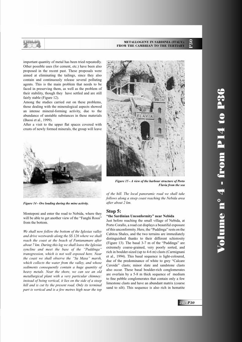
Driving along the ring-road south of Iglesias, after a short tunnel that crosses a small anticline in the sandstones of the Nebida Formation, we enter the Iglesias Valley, just at the eastern, arched closure of the syncline. We can see the Campo Pisano mine on the right, near the contact between the Nebida and the Gonnesa Formations.
Stop 1: Some geological details of the Iglesias Valley
Stop 1.1:Near the Campo Pisano mine. The upper part of the Gonnesa and the lower Cabitza Fms; view of the E-W Iglesiente syncline.The following formations are exposed in sequence.The Gonnesa Fm. (“Metallifero” Auctt., Lower Cambrian), represented here by the “Dolomia Rigata” Member and the “Dolomia Grigia” lithofacies;The Cabitza Fm. (Middle Cambrian - Lower Ordovician), mainly made up of multicoloured shales, and with the comparatively thin “Calcare Nodulare” Member (“Calcescisti” Auctt.) at its base (Carmignani et al., 1994).The transition from grey dolomite to nodular limestone is particularly interesting. The latter marks
the beginning of the submersion of the pericontinental platform system (“Calcare Ceroide” Member) after a short period of emersion, and the continuation of marine sedimentation infl uenced by terrigenous input.To the west we see the Iglesias syncline, a large E-W-trending structure, preceding the Sardinian Unconformity, and variously complicated by the interference of the N-S trending structure (the main Hercynian phase). The shales of the Cabitza Fm., at the core of the syncline, occupy the bottom of the valley; the Gonnesa Fm. forms the abrupt hills bordering on its northern and southern fl anks.
Stop 1.2:Slightly further on along the road, facing the Monteponi mine: the Cambrian sequence is unconformably overlain by Upper-Carboniferous sediments.The angular unconformity between the Cabitza Formation and the Upper Carboniferous detrital sediments is clearly visible in the road trenches. The contact is erosional and some small channels are evident near the base.Because of the Late Stephanian age of the deposits in the San Giorgio basin, it should be remembered that megafl ora such as Pecopteris arborescens (Schloth), Callipteridium pteridium (Schloth), Neuropteris planchardi (Zeiller), Dicksonite plukeneti (Schloth), sterzeli (Zeiller), and a few other species have been found. A Late Carboniferous age (Westphalian-Stephanian) is also confi rmed by the palynological data and by the presence of an ichnofauna with Salichnium heningi (Geinitz).
After travelling a few kilometres along the SS 126, we shall reach the San Giovanni mine, on the southern fl ank of the valley. Among the numerous points of interest in this area, two sites, displaying interesting karstic phenomena have been chosen for our second stop.
Stop 2a:Karst phenomena in the San Giovanni mine Stop 2a. This visit is of interest to the economic geologists. It is a visit to the “Ricchi Argento” ore and the “Geodic” dolomite in the “Ricchi Argento” district of the mine. The visit will be guided by Prof. M. Boni, who is also the author of the following paragraphs.After the end of the Variscan compression, during the Permian and Mesozoic, several pulses of extensional
P30_R_OK 15 21-06-2004, 9:37:41

Vo
lum
e n
° 4
- f
rom
P1
4 t
o P
36
P30 - 16
Leaders: A. Marcello, S. Pretti, P. Valera
P3
0
tectonics caused repeated openings of fractures in SW Sardinia, as well as a broad circulation of hydrothermal fl uids. These fl uids fi rstl caused a widespread pervasive dolomitization of the already deformed Lower Palaeozoic carbonates (“Geodic” dolomite), and then eventually precipitated base metals and barite ores (Boni et al.,, 2002 ,and references therein). High salinity fl uid inclusion analyses, combined with O- and radiogenic Sr-isotope data of the dolomites, indicate that the hydrothermal fl uid can be categorised as a “basinal brine” (Boni et al., 2000). The spread
in homogenisation temperatures of these dolomites, shows a gradient with values decreasing from east to west. The higher temperatures (mean of around 100 °C) have been measured in the eastern parts of the Iglesiente area, whereas the lowermost temperatures (mean of about 85 °C) have been found along the western coast of Iglesiente. The many subhorizontal open cavities within the “Geodic” dolomite, possibly controlled by shear tectonics (Figure N. 4), and only partly fi lled with cement, might point to fl uid overpressure at the time of dolomitization.No absolute dating was possible: the relative age of the “Geodic” dolomite can only be inferred by the crosscutting relationships of younger Pb-Ag-Ba low temperature veins on the dolomite lithologies. We are inclined to assign a Permian(?) age to this hydrothermal dolomitization, as in other European Late-Variscan domains (Boni et al., 2002, and references therein).In the whole region, a widespread erosion peneplain developed after the late-Variscan uplifts, causing also deep karstifi cation in the Cambrian (partially hydrothermally dolomitized) carbonates. This fracture-controlled, karstic network was almost
Figure 4 - Geodic dolomite with generation I (dark grey) and generation II (white, fi lling tension gashes and dilatational cracks). San Giovanni mine, lev. -60 (hammer = cm 35) (from Boni et al., 2000)
Figure 5 - Paleokarst collapse breccia and cockade ores with calcite, barite
and Ag-rich galena. San Giovanni mine, Scavi Peloggio
P30_R_OK 16 25-05-2004, 16:48:35

METALLOGENY IN SARDINIA (ITALY): FROM THE CAMBRIAN TO THE TERTIARY P
30
17 - P30
Vo
lum
e n
° 4
- f
rom
P1
4 t
o P
36
completely fi lled by internal sediments, collapse breccias and hydrothermal cements (Figure 5). As a result, several post-Variscan, low-temperature (<160oC), high salinity (>20 wt. % NaCl eq.) base metal-barite deposits occur throughout the Iglesiente-Sulcis region. These are especially common in the carbonate ridges (the Gonnesa Group of Early Cambrian age) along the Nebida coast and on the San Giovanni - San Giorgio and Barega hills. They represent the fi lling of vein- and paleokarst structures, with a simple ore mineral association of Ag-rich galena and barite (Figure 6).These concentrations were called the “Ricchi Argento” deposits. Owing to the paucity of geological constraints, the age of these mineralizing events has been set as between Permian and Mesozoic. Deposit tonnages are quite low, but, due to their high Ag content (several kg Ag/ton galena concentrate), they were fi rst exploited by the Phoenicians and Romans, and then by the Pisans in the Middle Ages. In several Iglesiente and Sulcis areas, as in the old Barega mine, abundant barite deposits occur in the same paleokarstic structures. Relating the low temperature-high salinity Pb-Ag-Ba vein- and paleokarst deposits, controlled by a younger set of fractures, to the inset of a Mesozoic (eo-Alpine) rifting phase has been proposed (Boni et al., 2002, and references therein). Unfortunately, every attempt at directly dating ore and gangue minerals related to this hydrothermal
phase has failed so far.The Cambrian carbonate sequence was then subjected, during the Tertiary and Quaternary, to further karstic dissolution, clearly enhanced by the high sulfi de content of the carbonates.
After Stop 1, continue to drive along the SS 126; the next destination of the itinerary is near the village of Gonnesa, south-west of Iglesias. At Gonnesa, we will start the ascent (about 1 hour on an old mining road) to San Giovanni hill, to reach the abandoned ore deposits of the paleokarst-hosted “Ricchi Argento”.Almost at the top of San Giovanni hill, some small adits at levels +267 and +290 are the entrance to the old “Ricchi Argento” orebodies (Figure N. 5). Silver is contained in several sulphosalts (mostly freibergite) in the galena. Near the entrance of the galleries the Gonnesa limestone (locally called “Ceroide”) is patchily dolomitized (“Geodica” to “Yellow”
Figure 6 - Silicifi ed internal sediments and calcite/barite crystals in a paleokarstic cavity. San Giovanni mine, Scavi Santa Maria
Figure 7 - Columns of snow-white calcite surrounded by eccentric concretions of aragonite
P30_R_OK 17 25-05-2004, 16:48:38

Vo
lum
e n
° 4
- f
rom
P1
4 t
o P
36
P30 - 18
Leaders: A. Marcello, S. Pretti, P. Valera
P3
0
dolomite) and shows evidence of polyphasic karstic dissolution. Underground, the ore deposits show concretionary textures and collapse breccias, cemented by several generations of calcite, quartz, barite and Ag-rich galena. Also repeated generations of internal karst sediments occur, possibly related to different dissolution and fi lling episodes (from
silicifi ed and dolomitized deposits, to speleothemes with aragonite and bone beds with “terra rossa”).
Stop 2b: This visit is dedicated to the accompanying members, and shows off the unique Santa Barbara cave, which was discovered inside the
San Giovanni mine. This mine is also reached from the SS 126. Local guides will accompany the visitors.The “Grotta di Santa Barbara” (Santa Barbara cave) was discovered by chance while excavating a riser in 1952. This riser fi rst crossed a body of Fe-Zn oxidised ore hosted in yellow dolomite, and then entered a band of waxy limestone, followed by aragonite concretions and a thick Fe-Mn-oxide crust (Marcello A. et al., 1994). This crust was followed by the very fl oor of the cave, which is made of yellow-pinkish barite crystals and perfectly white calcite. Finally, a single wide chamber was reached, developing for a length of about 80 metres (along a NS strike) and a width of 15 to 40 metres. Its maximum height is just over 25 metres, gradually decreasing southwards until a fi nal pointed closure.The roof elevation decreases irregularly from N to S as it follows the dip of the waxy limestone-grey dolomite contact. This less soluble lithology acted as a base level for the descending waters. In the lowest part (about + 182 m of elevation) there is a small lake.The main and most apparent elements are the stalactites, stalagmites, and columns of snow-white calcite sheets, delicate arabesques and eccentric concretions of aragonite that decorate the roof like precious laces, especially in the southern part of the cave (Figure 7). The stalactites, sometimes joined to the stalagmites to form columns, reach a remarkable sizes in both diameter and height. Equally beautiful are a formation shaped like an organ, and one in the shape of imposing “elephant ears” hanging from the roof of the cave (Figure 8).Though everyone fi nds these characteristics amazing, what particularly attracts us, and especially us mineralogists, is the delicate decoration, on walls free from calcite encrustation, due to the incredible covering of variously disposed, very consistently-sized, tabular crystals of brown-pinkish barite (Figure 9).
A careful examination shows that this barite
Figure 8 - Organ-pipe-shaped stalactites
Figure 9 - Tabular barite crystals, locally covered by white calcite
P30_R_OK 18 25-05-2004, 16:48:41

METALLOGENY IN SARDINIA (ITALY): FROM THE CAMBRIAN TO THE TERTIARY P
30
19 - P30
Vo
lum
e n
° 4
- f
rom
P1
4 t
o P
36
immediately followed the formation of hemispherical, mamillary concretions of calcite. The grotto is believed to be very old, as it appears to be related with the emersion of the Cambrian carbonatic rocks following the Hercynian orogeny. The deposition of hemispherical calcite and barite would be related to a sealing phase of the cavity and its fi lling with waters percolating from the overhanging fl at tops of Punta Is Ollastus, Punta della Torre, etc. The many barite-bearing ore bodies occurring here released the barium required to form the crystals.Apart from the normal formation of stalactites, stalagmites, and columns, and more generally the formation of calcite-aragonite concretions, the subsequent emptying out of the cavity determined the slow, progressive percolation of calcium-rich waters along its walls, and therefore onto the barite crystals. Though it has completely covered large surfaces of the walls, large parts are still not yet covered; nevertheless this unusual tapestry continues to astonish visitors.This cave is protected by the miners and is rarely visited, thus keeping it practically untouched by anthropic degradation.Now that a monitoring programme has been developed, the environmental conditions compatible with a certain level of regular tourist visits have been defi ned, thus affording maximum preservation to an almost unique natural wonder (there are rumours of another similar occurrence, but no references are available so far).The access to the cave is easy for people familiar with mines or in generally good healthy conditions. The visit involves climbing up a short riser, after a comfortable ride in a newly-built lift and a short trip by train along an old, well-preserved crosscut. Appropriate coats are recommended in this gallery, because of excessively ventilated conditions that
could be unpleasant especially in the presence of perspiration. Nice clothes should generally be avoided, and shoes suited to slippery conditions should be worn.Lunch in a restaurant at Iglesias.In the afternoon, the group will reach the famous Monteponi mine, now at the outskirts of the town.The visit will deal with a mining component (“Scavi Cungiaus”), and a treatment component (“Fanghi Rossi Elettrolisi”).
Stop 3: Old exploitation works on the oxidised outcrops of the “columns” of Monteponi (“Scavi Cungiaus”)Mining activities in the Metalliferous Ring of the Iglesiente date back at least to the Phoenician and Carthaginian periods. But it was only with the Romans that a systematic exploitation of the outcrops of the Monteponi area was carried out. The Romans, who were attracted by the silver-rich galena that occurred there, mainly extracted the outcropping ore by open-pit mining, though along the richest “columns” their shafts at times reached depths of 100 metres from the surface. It was only after the beginning of a true industrial exploitation that the excavations developed deeper and deeper,and mainly underground, eventually to reach a level of 150 m below sea level. The fi nal vertical development of the mine is of about 500 m. However, the open-pit works continued down to the deepest economically - and technically - possible level.Along the main internal road of the old mine, we reach the highest mine district. The hill top has almost completely been removed by open-pit excavations of the “Scavi Cungiaus”(Figure 10) (Società di Monteponi, 1952).
Figure 10 - The open-pit excavations of “Scavi Cungiaus”
Figure 11 - Palazzo Bellavista in 1870
P30_R_OK 19 25-05-2004, 16:48:44

Vo
lum
e n
° 4
- f
rom
P1
4 t
o P
36
P30 - 20
Leaders: A. Marcello, S. Pretti, P. Valera
P3
0
After the Roman works mentioned above, which were continued by the Pisans and the Spaniards in the Middle Ages especially on the silver rich oxidised Pb ores, the main development of these open-pit works began in 1867, when rich calamine bodies were detected. Both the Pb- and the Zn-rich bodies exploited here represent merely the oxidised outcrops of many of the numerous columnar bodies known in this mine, and of these bodies (which bodies: the Pb- and the Zn-rich ones or the columnar ones?) they maintain the remarkable horizontal sections (even enlarged on account of well known surface phenomena) as well as the steep dip mentioned above. The initial trials of underground works were fi nally included in the large funnel-shaped open pits visible at present. These works include fi ve main excavations. At the beginning of the second half of the last century, when they reached maximum development, the “Scavo Biscia”, which was the largest pit, was an elliptical funnel 250 m in length, 150 m in width, and 80 m in depth. The volume of material extracted here was three fourths of the total material mined in these works, which was over 1M m3. The main ore minerals occurring in these works include smithsonite
with minor hemimorphite, normally impure due to abundant limonite (which caused severe metal losses during the mineralurgical treatment). The main lead mineral was galena, both the fi nely grained primary sulphide and a secondary spathic mineral. This was accompanied by a number of oxidised Pb minerals, often displaying perfectly crystalline habits, and frequently as associations of giant crystals. These specimens are famous among mineral collectors and displayed in a number of museums all over the world. The secondary Ag enrichment reached a mean content of 400 g Ag/ton Pb in these surface bodies, compared to a mean of 100 g Ag/ton Pb in the deeper galenas.
A signifi cant Hg enrichment was also noticed in these ores.
Stop 4:Metallurgical wastes from a Zn electrolytic plant, the so-called “Fanghi Rossi” (“Red Muds”)After leaving the Cungiaus works, we shall return to the centre of the mine complex, near the old management building (Palazzo Bellavista, a beautiful XIX century villa, now the seat of a branch of the University of Cagliari) (Figure 11), and the nearby old electrolytic plant, which used sulphuric acid, FeSO
4,
and MnO2 to process oxidized Zn-ores from 1926 up
to 1983, with the necessary technical improvements made over time.The fi ne tailings of this plant were long heaped up downslope at the rear. Since the ores mainly treated in the plant were iron-rich calamines of the Metalliferous Ring, these tailings mostly consist of iron oxides and hydroxides, which explains their bright red colour. For this reason the “Fanghi Rossi” are now considered a peculiar element of the local landscape, and have been declared untouchable. Actually, they still contain about 9 wt% Zn, and an economic recovery of this
Figure 12 - A partial view of the “Fanghi Rossi”
Figure 13 - The “Sardinian Unconformity, near Nebida. The Unconformity’s surface is marked by the dashed line.
P30_R_OK 20 25-05-2004, 16:48:46
METALLOGENY IN SARDINIA (ITALY): FROM THE CAMBRIAN TO THE TERTIARY P
30
21 - P30
Vo
lum
e n
° 4
- f
rom
P1
4 t
o P
36
important quantity of metal has been tried repeatedly. Other possible uses (for cement, etc.) have been also proposed in the recent past. These proposals were aimed at eliminating the tailings, since they also contain and continuously release several polluting agents. This is the main problem that needs to be faced in preserving them, as well as the problem of their stability, though they have settled and are still fairly stable (Figure 12).Among the studies carried out on these problems, those dealing with the mineralogical aspects showed an intense mineral-forming activity, due to the abundance of unstable substances in these materials (Buosi et al., 1999).After a visit to the upper fl at spaces covered with crusts of newly formed minerals, the group will leave
Monteponi and enter the road to Nebida, where they will be able to get another view of the “Fanghi Rossi” from the bottom.
We shall now follow the bottom of the Iglesias valley and drive westwards along the SS 126 where we shall reach the coast at the beach of Funtanamare after about 7 km. During this leg we shall leave the Iglesias syncline and meet the base of the “Puddinga“ transgression, which is not well exposed here. Near the coast we shall observe the “Sa Masa” marsh, which collects the water from the valley, and whose sediments consequently contain a huge quantity of heavy metals. Near the shore, we can see an old metallurgical plant with a very particular chimney: instead of being vertical, it lies on the side of a steep hill and is cut by the present road. Only its terminal part is vertical and is a few metres high near the top
of the hill. The local panoramic road we shall take follows along a steep coast reaching the Nebida area after about 2 km.
Stop 5: “the Sardinian Unconformity” near Nebida Just before reaching the small village of Nebida, at Porto Corallo, a road cut displays a beautiful exposure of this unconformity. Here, the “Puddinga” rests on the Cabitza Shales, and the two terrains are immediately distinguished thanks to their different schistosity (Figure 13). The basal 3-7 m of the “Puddinga” are extremely coarse-grained, very poorly sorted, and rich in boulder-sized (up to 4-6 m) clasts (Carmignani et al., 1994). This basal sequence is light-coloured, due of the predominance of white to grey “Calcare Ceroide” clasts; minor slate and sandstone clasts also occur. These basal boulder-rich conglomerates are overlain by a 5-8 m thick sequence of medium to fi ne pebble conglomerates that contain only a few limestone clasts and have an abundant matrix (coarse sand to silt). This sequence is also rich in hematite
Figure 14 - Ore loading during the mine activity.
Figure 15 - A view of the harbour structure of Porto Flavia from the sea
P30_R_OK 21 25-05-2004, 16:48:50

Vo
lum
e n
° 4
- f
rom
P1
4 t
o P
36
P30 - 22
Leaders: A. Marcello, S. Pretti, P. Valera
P3
0
particles and hematitic slate clasts, thus it displays a deep-red colour.
At the top of the slope, a fl at area, a remnant of the post-Hercynian peneplane, is covered by sub-horizontal beds belonging to the mentioned sedimentation phase, possibly of Early Mesozoic age, following the peneplanation.
Stop 6: “Puddinga” at the Nebida promenadeAt the southern corner of the village, a panoramic promenade has been built. It affords a scenic view of the coast and is characterised by multicoloured cliffs and “faraglioni”[explain this term].Along this promenade the lowest part of the “Puddinga” is exposed, with the exception of the very basal beds, which are offset by a fault. The exposed beds show a variety in thickness, colour, matrix content, and size, as well as differences in the rounding and sorting of the clasts.
A further short drive will lead us to the mine of Masua, which was kept active up to a few years ago. This mine was a very important production centre for most of the XX century. The loading plant at Porto Flavia is quickly reached from the ore-dressing plants of this mine.
Stop 7: The ship-loading plant at Porto FlaviaFrom the beginning of industrial production at the Iglesiente mines, the transport of its ore concentrates represented an important economic problem. Since there were no ports or docks on the coast suitable to load cargo boats, most mines used the services of the Galanzé watermen from the island of S. Pietro. These watermen ferried goods from the beaches of Masua, Funtanamare, Cala Domestica, Canal Grande, and Buggerru to the spacious storehouses on the island of S. Pietro, where the goods were fi nally stowed into cargo boats. The repeated operations of loading and unloading obviously increased the overall costs of the goods.
For this reason, at the beginning of the last century a harbour structure capable of receiving and loading larger vessels was planned by the Belgian company Vieille Montagne, which then managed the Masua mine. This structure was completed in 1924, and named “Porto Flavia” (Figure 14), after the name of one of the daughters of its designer.
The loading structure has two superimposed tunnels which cut across a limestone massif falling sheer to the sea (Ardau et al., 2001) (Figure 15). The upper gallery, at 37.4 m a.s.1, is 600 m long, and was equipped with an electric railway connecting it with the Masua processing plant. The lower gallery, at 16 m a.s.1., was 100 m long, and contained a long conveyer belt that terminated at the opening on the cliff and could extend a mobile arm 20 m out beyond the cliff, over the sea. Nine silos were dug between the two galleries, each containing up to 10,000 tons of galena, sphalerite, and calamine concentrates. These silos were fed from the upper gallery and unloaded onto the conveyer belt of the lower gallery by mechanical hoppers. The concentrates then reached the lever arm and were loaded directly onto cargo boats at the base of the cliff overlooking “Pan di Zucchero” (“Sugarloaf”) - an imposing calcareous rock so called because of its sugar-white colour.The next lap after the visit to the restored Porto Flavia is rather long and winding. However, in return, the views are breathtaking, the geology interesting
Figure 16 - A partial view of the Quaternary aeolian dune complex of Piscinas
P30_R_OK 22 25-05-2004, 16:48:52

METALLOGENY IN SARDINIA (ITALY): FROM THE CAMBRIAN TO THE TERTIARY P
30
23 - P30
Vo
lum
e n
° 4
- f
rom
P1
4 t
o P
36
(including almost all the Palaeozoic terrains of Iglesiente), and we shall pass through some historically important mining sites, such as Buggerru and Fluminimaggiore. In the evening we shall stop at the beautiful beach of Piscinas, where we shall lodge and have our last stop for the day.
Stop 8: The sand dunes of PiscinasThe Piscinas dune complex is made up of Quaternary aeolian dunes. This complex covers an area of almost 20 km2, and reaches a height of 200 metres locally. The sands are stabilised by an abundant amanthophilous vegetation that can resist strong insolation and drought. This is an important part of the habitat of the Sardinian deer, an endangered species now carefully protected (Figure 16).The beach is 50 to 100 metres wide, and over 5 km long. The shore stream, the main modelling agent, is directed NNE-SSW, and the dominant wind is the mistral.
DAY 3
Itinerary: Piscinas, Ingurtosu, Montevecchio, Bosa, Alghero
From the beach of Piscinas, we shall return along the same road as the day before, and visit the old mines that operated on the considerable lode system of Montevecchio-Ingurtosu-Gennamari in the Arburese-Fluminese district.Geological Scheme of Arburese-FlumineseThis region forms the northern part of the south-western Palaeozoic massif of Sardinia, a triangle between the Sea of Sardinia on the west and the Campidano graben on the east, and, southwards, the northern reliefs of the Metalliferous Ring of Iglesiente.The terrains outcropping in this region are mainly terrigenous complexes of Lower Palaeozoic age, including the northernmost outcrops of “Puddinga”, the arenaceous shales of the Upper Ordovician, and the Silurian black shales with interbedded limestone lenses. The northernmost thick complex of metasandstones, with interbedded acidic metavolcanics (the so-called “Porfi roidi”) is still known as “Post-Gotlandiano”, but it is now compared with the Lower Palaeozoic siliciclastic San Vito Formation of south-eastern Sardinia.These terrains host important intrusions of Hercynian granitoids, which outcrop in four places: two minor
bodies, at Capo Pecora and Arenas-Tiny, and two major bodies, the plutons of Monte Linas and Arburese, which are surrounded by several vein
systems displaying many kinds of mineralisation.The last terrains of some importance in this region are the Quaternary volcanics along the main faults of the Campidano graben: a dissected basaltic edifi ce, centred on the Monte Nurecci diabase stock and culminating at Monte Arcuentu, with its beautiful system of radial basalt dikes, and its northern lava fl ows covering the peninsula of Capo Frasca.
Mineralisations of Arburese-FlumineseThis northern part of the Sulcis-Iglesiente massif also includes a variety of ore occurrences, although the most numerically and economically important ones are the vein systems, and the predominating ore-forming phenomena are related to granite intrusion. Along the northern boundary of Iglesiente (a historical boundary which actuallyrefl ects the variation of geologic style ) a few stratabound occurrences, related to the Sardinian Unconformity, include important lead-barite bodies, and minor concentrations of almost pure hematite. Among the lead-barite bodies, particularly noteworthy is that of Arenas, because its main ore mineral is cerussite, with minor galena confi ned to a few palaeokarstic fi llings.Furthermore some fl uorite concentrations occurring in the northernmost outcropping blocks of Cambrian limestone are attributed to post-Hercynian karst fi lling. Nevertheless, some phenomena related to high temperatures are also known (e.g. skarn bodies tightly confi ning the fl uorite ones, and the occurrence of octahedral fl uorite in the mine of Su Zurfuru).As elsewhere in Sardinia, mixed-sulphide stratabound occurrences are widespread, and mostly
Figure 17 - Schematic section of the Montevecchio-Ingurtosu-Gennamari lode system at Montevecchio:
1. Hercynian granite; 2.contact metamorphic halo; 3. sandstones and shales; 4. limestones and conglomerates;
5. tuffs and breccias; 6. acidic metavolcanics; 7. mineralizated bodies. (after Zuffardi, 1982, modifi ed)
P30_R_OK 23 25-05-2004, 16:48:54

Vo
lum
e n
° 4
- f
rom
P1
4 t
o P
36
P30 - 24
Leaders: A. Marcello, S. Pretti, P. Valera
P3
0
associated with the limestone lenses interbedded with the Silurian black shales. Although their primary origin is commonly referred to as synsedimentary or volcano-sedimentary, certainly the contribution of thermal phenomena by Hercynian granitisation is unquestionable, because most often these bodies are now true skarns. On the other hand, ore-bearing skarns derived from rocks of different ages, such as those of Su Zurfuru mentioned above, also occur. In addition, the high indium contents, as well as the presence of tin observed in some of these bodies, would also imply a metal contribution from hydrothemal fl uids.Other occurrences are unquestionably related to fl uid motion generated by the granite bodies; among those with the highest-thermality are porphyry- and greisen-type molybdenum occurrences on the eastern fl ank of the Monte Linas batholith, wolframite-bearing quartz veins on its northern side, and cassiterite-arsenopyrite-bearing quartz veins westwards of the same massif.The remaining vein–shaped bodies include medium- to low-thermality occurrences, arranged as peripheral or radial vein and lode systems. The radial veins SE of Monte Linas are mineralised with Pb-Zn-Cu-Sn-bearing sulphides and sulphosalts. The peripheral vein system south of Monte Linas displays an impressive variety of sulphides and sulphosalts of Ni, Co, Pb, Zn, Cu, Ag, and Bi. Another minor, though partially exploited occurrence is a low-thermality siderite body NE of the same massif.But the really important occurrence is the huge mesothermal lode system of Montevecchio-Ingurtosu-Gennamari, which borders the northern side of the Arburese pluton, an elliptical granite body with a mean diameter of about 10 km (Zuffardi 1982). This system includes both radial bodies, generally of minor economic importance, and kilometre-sized peripheral bodies, forming sub-systems roughly parallel to the border of the batholith, with an overall longitudinal extension of some 12 km (Figure 17). Starting from the western side, besides minor variously-directed veins, the main bodies display strikes from roughly N-S to about NE-SW in the zone of the old mine of Gennamari. In the area of Ingurtosu, the latter converge with the “Main Belt”, reaching it approximately where the propertyof the old mine of Montevecchio begin. This “Main Belt” includes a couple of ENE-WSW fractures, steeply dipping and extending over 6 km, and fi lled almost continuously by prevalently Zn-rich ores, found down to 600 m below the outcrops. The intermediate septum, 50 to 80 m thick, hosts several minor, but often economically mineralised veins. Near the eastern extremity of
this belt, another important vein family, richer in Pb, branches out running E-W for about 2 km, before being abruptly offset eastwards by the main Campidano faults. This family displays a classical telescoping of the Pb-Zn mineralisation downwards, and an unexpected repetition of the cycle below the –60 level. This two-phase mineralisation caused a notable vertical extension of the Sant’Antonio vein, which has been exploited down to 600 m below the outcrops.The single ore lenses are 1.5 to 7-8 m thick, but the overall thickness of all the veins at any given level always exceeds 6 m, with peaks of 25 m.The mineral assemblage mainly includes Fe-bearing sphalerite (marmatite), galena, and pyrite, in variable proportions, and minor chalcopyrite and other sulphides and sulphosalts; the main gangue minerals are quartz and ankerite.The total metal production of these mines amounts to 5M tons of Pb + Zn, besides minor, but very important, quantities of Ag and Cd that are regularly recovered from the metallurgical treatments of, respectively, the Pb and Zn concentrates.To realise the importance of this deposit, we shall say a few words on the history of Montevecchio, the easternmost of the three mines that operated here.Archaeological fi ndings show that in Roman times exploitations were conducted in the upper parts of these lodes, and it is quite likely that previous mining operations did occur (lead and silver were surely used by the Nuragic people of the Bronze Age, and were certainly traded by Phoenicians and Carthaginians). Moreover, important mining operations during the Pisan and Aragonese periods (Middle to Modern Ages) are well documented. But the industrial activity proper began in 1848, when the King of Sardinia, Charles Albert of Savoy, issued a series of perpetual mining concessions, thus giving birth to the modern mine. This lasted about 150 years. The works commenced on the rich Sant’Antonio lode, and in 1852 the so-called Anglosarda Level immediately revealed fabulous galena enrichments. Consequently, the fi rst industrial treatment plant was built near this adit. With the opening of the lower Sant’Antonio Level, the constant richness of the lode was confi rmed, and the sinking of a shaft, Pozzo Sant’Antonio, was commenced in 1872. In 1877, during the visit of Prince Thomas of Savoy, the new ore-dressing plant was inaugurated (for which reason it was named Laveria Principe). This plant was regularly modernised and lasted till the end of the mine. The prince was offered a famous banquet in a
P30_R_OK 24 25-05-2004, 16:48:57

METALLOGENY IN SARDINIA (ITALY): FROM THE CAMBRIAN TO THE TERTIARY P
30
25 - P30
Vo
lum
e n
° 4
- f
rom
P1
4 t
o P
36
banqueting-hall that was completely hollowed out in a single lens of massive, pure galena at the Anglosarda Level.This mine fl ourished until the 1960s, when it began to decline: it was defi nitively shut down in 1991.All along the development of this important vein system, along which we shall drive, we can see important traces of the intense long-lasting human activity; fi rst of all, the villages of Ingurtosu and Montevecchio, once lively and rich, now practically abandoned; then a number of open-pit works and adits, with their dumps, shafts, satellite plants, and ore-dressing plants, and their tailings. The accumulations of mining waste continuously release a large amount of polluting substances into the meteoric waters, which together with the waters fl owing out of some adits, reach local streams. The effect on the water and sediments of these small streams is obvious and easily visible. The next road we take from the beach of Piscinas climbs up the valley of Rio Naracauli, one of the above-mentioned streams.
Stop 1: Pollution phenomena along Rio NaracauliRio Naracauli fl ows from the site of Ingurtosu, with its extraction and treatment plants, to the beach of Piscinas (Figure 18). Close to Ingurtosu, and spread along this valley covering an area of about 20 km2, an overall volume of tailing and waste material of 750,000 m3 has been assessed, 350,000 m3 of which form a mixed deposit close to the mouth of the stream. Studies on these materials have shown that they still contain a variety of minerals both from the unaltered and the oxidised parts of the exploited lodes, and include sphalerite, galena, pyrite, chalcopyrite, greenockite, cerussite, anglesite, monheimite (Fe-smithsonite), Fe oxides and hydroxides, besides the gangue minerals quartz, ankerite, siderite, barite, and clay minerals. After further oxidation of the sulphide fraction, Fe, Zn, Ca, and Mg soluble sulphates form along with further Fe hydroxides. A striking consequence of these phenomena is the formation of small concretions, mainly of gypsum and Mg sulphates (Zn-rich epsomite and hexahedrite), often also cementing small crystals of Ba, Pb, and Cd sulphates as a result of precipitation from oversaturated waters. Given these conditions, it is obvious that a considerable load of pollutants is transported to the sea. It has been evaluated that in low fl ow conditions the amounts of metals that are discharged into the sea, expressed in kg/day, are: Zn 34; V 1.4; W 0.8; Cd 0.27; Ni 0.08; Pb 0.02.
Our route will continue along the valley as far as Ingurtosu.
Stop 2:The village of IngurtosuThe village of Ingurtosu was the seat of the administrative and logistical headquarters of the important mine of the same name, as well as the main residential centre for local miners. The edifi ces were built between the second half of the XIX century and the fi rst half of the XX century, and include fi ne examples of the “mining architecture” typical of that golden period of Sardinian mines (Figure 19). After several years of neglect, many of these buildings have been restored and are now open to visitors.
Now, along a road that interconnects the mines and follows the outcrops of the “Main Belt”, we shall visit the second important village, Montevecchio. Along our route we shall see a number of shafts, adits, trenches, and open-pit works, lined up along the imposing outcrops of the veins. Depending on time availability, we may dedicate a few minutes for a short look at some of these sites.
Stop 3:The village of MontevecchioIn some respects this village is quite similar to Ingurtosu, except that the mine being more productive and for a longer time, Montevecchio is simply larger and richer than Ingurtosu. Actually, the restored management building of this mine is a masterpiece of “mining architecture”, and surely deserves a visit, as does the local museum, which illustrates the history of local mining activity and contains a beautiful collection of mineral samples. In the end, we shall have a quick look at the historical Pozzo Sant’Antonio and the Laveria Principe. Moreover the imposing walls of the mafi c dikes of Monte Arcuentu are well visible from this siteAfter leaving the village, we shall drive along the Rio di Montevecchio stream, which shows conditions of pollution similar to, if not worse than, those of Rio Naracauli. After a few kilometres we shall reach the town of Guspini, which together with the nearby Arbus, is where most of the miners of the Arburese district come from. We shall then head north and get on the SS 131.Along our route, which includes a stop for lunch, we shall cross the northern part of Campidano,
P30_R_OK 25 25-05-2004, 16:48:59

Vo
lum
e n
° 4
- f
rom
P1
4 t
o P
36
P30 - 26
Leaders: A. Marcello, S. Pretti, P. Valera
P3
0
bordered by the two Quaternary volcanoes of the basaltic Monte Arcuentu on the south-west, and on the north-east the mostly rhyolitic Monte Arci, rich in obsidian fl ows, partially transformed into actively-mined perlite. After about an hour, we shall leave the SS131, and encounter Oristano, an old town now the capital of thesynonymous province. We shall then proceed north on a good district road, crossing the sand dunes of Is Arenas, up to the northern extremity of Campidano. This is dominated by Monte Ferru, the largest volcano on the island, with its calc-alkaline Tertiary roots, where important gold indications have also been detected (Fadda et al., 2003), and the Quaternary edifi ce above 1000 m, which is formed mostly of sub-alkaline basalts.Our route will run between the western side of the volcano and the coast, on terrains including
Oligocene volcanics, Miocene sediments, and patches of Quaternary basalt fl ows. Where the road approaches the coast, we shall pass by important holiday resorts, such as Santa Caterina and S’Archittu. The pre-Roman and Roman sites of Tharros and Cornus are not far from our road, as well as numerous Nuraghes, many of which can be seen on the way. About one hour’s drive from Oristano we shall reach the town of Tresnuraghes (whose name means “Three Nuraghes”), the fi rst of a group of towns that almost lean against each other in the Planargia region. After passing through other smaller towns, we shall descend to Bosa, a pretty town of pre-Roman origin at the mouth of the river Temo, the only fl uvial harbour in Sardinia. North of Bosa, the main Oligocene volcanic district of Sardinia begins. Close to the town, small manganese occurrences were explored and partially exploited in the past, and
a little further away, in the Capo Marargiu area, in the small but numerous recognised epithermal base-metal-bearing occurrences, gold contents were fi rst detected (Dessì et al., 1996).Now, the coastal panoramic road is dominated by steep cliffs formed by the thick series of calc-alkaline volcanics of Monte Mannu, where the last vulture colony of Sardinia still survives. A few road cuts display epithermal veins and stockworks made up of quartz, calcite, zeolites, sometimes in fi ne crystal aggregates, and minor sulphides. Finally, we reach the town of Alghero, a renowned marine locality, famous also for its “Grotta di Nettuno” (Neptune’s Cave), that opens onto the sea below the high Mesozoic limestone precipice of the Capo Caccia promontory. Here we shall stop for an overnight stay.
DAY 4Itinerary: Alghero, Florinas, Nuoro
Our trip proceeds northwards up to the north-western corner of the island. In this part of Sardinia ore-forming phenomena related with Mesozoic and Tertiary terrains prevail, although Palaeozoic occurrences are not missing..
Geological Schema of NE SardiniaThis part of the island mainly includes the northern extremity of the Tertiary Sardinian Rift between its western pillar, including Palaeozoic and Mesozoic terrains, and the eastern one, including Palaeozoic, mostly-granitoid terrains.The Palaeozoic metamorphic basement is well exposed near the coast in the westernmost sector of the Nurra region, while westwards it is reduced to fragments of roof-pendants of the wide granitoid complex of Gallura. The northernmost strip is partially covered by Permian volcanics. Grey Autunian arenites and siltites, unconformably capped by Upper Permian-Triassic continental red beds, deposited with interlayered alkaline volcanics on the western basement. The fi rst transgressive deposits consist of dolostones, fossiliferous limestones, and evaporites of Middle Triassic age with typical Germanic facies. These terrains widely outcrop in the western and southern parts of Nurra.From this time, shallow marine sedimentation in a carbonate platform environment was almost continuous until the Aptian-Albian time, before the emersion that gave rise to a gap related to the formation of bauxite. During this time an important
Figure 18 - Rio Naracauli and the ore-dressing plants
P30_R_OK 26 25-05-2004, 16:49:01

METALLOGENY IN SARDINIA (ITALY): FROM THE CAMBRIAN TO THE TERTIARY P
30
27 - P30
Vo
lum
e n
° 4
- f
rom
P1
4 t
o P
36
tectonic phase Austrian Phase) also took place.During the Coniacian all this palaeo-surface was submerged, due to a new transgression that led to carbonate-terrigenous sedimentation, and which lasted up to the Maastrichtian. The post-Maastrichtian emersion is supposedly related to a new tectonic phase (Laramic phase).From the Paleocene, the entire area experienced weathering and erosion followed by the widespread Oligocene calc-alkaline volcanism. During the last transgression in the Miocene, most of the lows formed in the Sardinian Rift were covered by an epicontinental sea, which left mostly terrigenous sediments still extensively outcropping in the central planes of this area. The emersion during the Late Miocene led to the present continental conditions. The last remarkable episode is the eruption of the Quaternary sub-alkaline basalts, which formed the youngest eruptive centres of the island (a little more than 100,000 years b.p.) in Meilogu, the southernmost region of this area, and covered the Central Plateau at its southern boundary.
The Mineralisations of NW SardiniaAs said above, most of the important economic mineral occurrences of this part of the island belong to Mesozoic and Tertiary times (sixth and seventh metallogenic periods). However, ore occurrences related to the Palaeozoic magmatism are not lacking:(I) volcano-sedimentary oolitic iron lenses, actively exploited in the fi rst half of the last century ( Canaglia mine, Nurra);(II) porphyry-type Cu occurrences, related to melanocratic-granitoid differentiations (at Bortigiadas and Ozieri, at the eastern margin of the zone examined);(III) greisen-type Mo, at a granite-micaschist contact
(at Oschiri, also at the eastern margin);(IV) hydrothermal Pb-Zn-, and Sb-bearing veins, some of which more or less actively exploited in the past (the important Pb-Zn mine of Argentiera, Nurra, and the smaller mine of Suelzu, near Ozieri).As to the Mesozoic occurrences, as already seen in the previous paragraph, the post-Albian gap in the Mesozoic series of Nurra is marked by a wide bauxite occurrence, which has recently been carefully explored, and is now being exploited. Important gypsum occurrences have also been taken into consideration, but never exploited.The Tertiary mineralisations include occurrences related to the Oligocene volcanism, and to the Miocene sedimentation.The volcanism-related occurrences include different types: porphyry-Cu, Mn- and precious-metal-bearing epithermal veins, volcano-sedimentary Mn lenses, as well as bentonite and kaolin lenses, formed after pyroclastites, possibly altered by hydrothermal fl uids.The porphyry-Cu occurrence of Calabona, a locality now at the very periphery of the town of Alghero, in the past was the site of a copper mine that exploited important rich lenses of oxidised minerals and regenerated Cu sulphides (the magnifi cent covellite specimens from this mine are still famous and present in several mineralogical museums all over the world) capping the primary mineralisation hosted in a thick porphyrite dike. The Pb-Zn-bearing skarns on Palaeozoic limestones leaning against the porphyrite were also partially exploited. The primary body has recently been explored, but the assessed mean grade and overall tonnage were judged insuffi cient to justify an underground exploitation imposed by the vicinity of the town. This exploration campaign also discovered gold-bearing silicifi ed bodies, both buried and outcropping. The vicinity of the town and its crowded beaches are diffi cult obstacles to get over to exploit these bodies.Epithermal and volcano-sedimentary manifestations are spread all over this area, where the volcanics are suffi ciently thick and widely outcropping.An economic-size gold-silver-bearing vein swarm, which was discovered by the same team not long after their fi rst discovery of the Furtei occurrence, occurs between the towns of Osilo and Nulvi, east of Sassari (Garbarino et al., 1991, Simeone et al., 1999). In these low-sulphidation-type veins, some of which exceed one kilometre in length, the ore-mineral assemblage includes pyrite, galena, sphalerite, chalcopyrite, bornite, chalcocite, stibnite, and freibergite in various
Figure 19 -Partial view of the Headquarters of Ingurtosu.
P30_R_OK 27 25-05-2004, 16:49:03

Vo
lum
e n
° 4
- f
rom
P1
4 t
o P
36
P30 - 28
Leaders: A. Marcello, S. Pretti, P. Valera
P3
0
proportions, and electrum as the main carrier of gold and silver, in a gangue mainly made of quartz. A wide alteration halo develops a broad andesite body in the host rock, and mainly includes propylitic, intermediate argillic, and potassic alteration. Potassic alteration is often so intense to form potassium-rich facies attaining a 14 wt% content in K
2O. Unfortunately the
normally high Fe content prevents exploitation of this material as a good industrial mineral. In regards to the Au-Ag mineralisation, after a careful exploration the exploitation concession was applied for, but it has not yet been possible to start industrial activity due to local policy problems.Mn-oxide occurrences, variously referred to as epithermal, exhalative, volcano-sedimentary, and sedimentary, are known to be spread all over the volcanic areas of north-western Sardinia. The possibly-epithermal Mn-bearing quartz-chalcedony veins outcropping in the Monte Sassu area, E of the
Osilo-Nulvi goldfi eld, would be very interesting because of their high Wcontent, but unfortunately their overall tonnage is quite low. Other slightly larger occurrences are known in the south-west, a few of which were also partially exploited. Among these, the occurrence of S’Alghentalzu has recently been re-examined, and proved to be related to a Miocene coastal line, thus possibly of purely sedimentary origin.The late and fi nal episodes of calc-alkaline volcanism reach the Miocene, and levels made of volcanic material, often epiclastic, often occur at the base of the epicontinental sea sediments of this period, or interbedded with them. The base metals (mostly Cu) of the oxidised minerals and sulphosalts, forming several small stratabound occurrences widespread
in the Meilogu region, are thought to derive from the early erosion of near-surface, volcanism-related mineralisations. Numerous, and sometimes important, bentonite occurrences, formed at the expense of the above volcanic levels, after alteration phenomena that have been judged hydrothermal, or deuteric in some instances and supergenic in others. The kaolin occurrences, which are less important and numerous, are more directly related to the volcanics. The two above possibilities are therefore also commonly envisaged for their genesis.Another important kind of occurrence is that of extensive and thick quartz-feldspar sands, weakly cemented by kaolinitic clay, which mark the base of the Miocene transgression at its progress in space and time(????). These sands are well known in Meilogu and have long been exploited as concrete and mortar sands, but recent investigation has proved that a good deal of them are low-iron, so that high-quality quartz, feldspar, and kaolin concentrates can easily be recovered. Actually, an important mine is in operation at present, and its production, opportunely diversifi ed, is steadily increasing.
Figure 20 - Aerial view of the Sant’Antonio sector of Montevecchio, showing: excavation at the outcrops of the Sant’Antonio lode (upper part); the Sant’Antonio and Sartori shafts, and the Laveria Principe ore-dressing plant (central-upper part); treatment tailings (lower half).
P30_R_OK 28 27-05-2004, 14:07:32

METALLOGENY IN SARDINIA (ITALY): FROM THE CAMBRIAN TO THE TERTIARY P
30
29 - P30
Vo
lum
e n
° 4
- f
rom
P1
4 t
o P
36
After leaving Alghero, we drive in a north-east direction along the SS 291, to the main bauxite plants of the Grascioleddu mine, close to the town of Olmedo. The plain between the two towns is mostly covered by a thick fertile soil, where intensel- cultivated vineyards produce prized varieies of wine. These soils cover the Mesozoic limestones. Where they outcrop, the bauxite-hosting gap is often exposed, and several exploration works are spread throughout the plane. Starting from Grascioleddu, a wide block of the Mesozoic complex is uplifted, clearly exposing the bauxite horizon.
Stop 1: The bauxite mine of OlmedoWe have already seen that this bauxite occurrence develops upon a gap occurring between the Aptian-Albian and the Coniacian. The nature of the pre-gap succession plays an important role in the genesis of the bauxite, as it contains some marly-clayey beds that can supply aluminium-rich material, suggesting that this succession is likely to represent the mother rock of the ore.
Local geological outlineDue to a mild angular unconformity, the bauxite deposits in Nurra rest on a footwall of rocks of an age spanning from the Oxfordian to the Early Aptian, depending on the structural arrangement that took place during the Middle Cretaceous emersion. These rocks include: a mainly dolomitic succession with oolitic limestones (Kimmeridgian-Oxfordian); a calcareous-dolomitic series (Portlandian); a mainly marly “Purbeckian” facies succession (Berriasian-Valanginian); dolomitic (Barremian) limestones; and “Urgonian” facies limestones (Barremian-Lower Aptian). After the bauxite horizon, possibly of Turonian age, the following transgression starts with a calcareous conglomerate (including reworked bauxite pebbles), followed by a thick series including limestones, marls, and calcarenites of Coniacian age. The Mesozoic series is concluded by a Santonian hippurite-bearing limestone, followed by Campanian-Maastrichtian marls and arenites.The Mesozoic is partially covered by Tertiary volcanic and sedimentary terrains, including Lower Miocene, welded pyroclastite fl ows alternating with ash-pumice fall beds, often altered into bentonite, and transgressive Burdigalian to Serravallian bioclastic limestones and marls.The tectonic instability, which started in the Middle-Cretaceous with a transtensive regime followed by a
transpressive one, caused an angular unconformity between the Lower Aptian and the Upper Turonian and/or Lower Coniacian and the bauxitic gap. The effects of these tectonics resulted in some uplifted blocks bounded by normal faults, and in a few mild folds. The subsequent movements of Late Cretaceous age caused an uplift, while from the Upper Burdigalian to the Pliocene an extensional regime took place, giving rise to normal faults with different directions. The structural depression where Upper Cretaceous sediments are preserved - i.e. where the occurrence of bauxite is highly probable - are linked to these movements; in particular, a wide ENE-trending syncline hosts the most important productive deposit.
The bauxiteThe bauxitic surface formed after the erosion of at least 600 metres of Mesozoic sequence; the oldest rocks were exposed north-westwards (bauxite lying on Oxfordian dolostones at La Campana) whereas the youngest ones were exposed at the ENE and WSW corners of the Mesozoic Nurra (Lower Aptian at Uri and Capo Caccia, respectively).The Nurra bauxites are essentially bohemitic; gibbsite and diaspore have been detected as traces in a couple of cases. Three main types of bauxite deposits have been distinguished (Oggiano et al., 2001). (I) Stratiform, autochthonous ore: this forms a deposit with wide lateral continuity, characterised by an almost constant thickness (2-3 m). The bauxite derives from in situ ferrallitisation at the expense of illitic Purbeckian facies marls, which led to a kaolinite-bohemite bauxite with 10 wt% content of hematite and goethite. These iron phases are not uniformly distributed, but confi ned within irregular reddish patches; thus zones of totally bleached ore are common. Nor is kaolinite (the only silica-carrier mineral) mixed with bohemite, but mostly confi ned in the lowest part, where it is concentrated and diminishes progressively towards the core of the horizon. The top of the horizon is formed of detrital bauxite, which lies on the erosional surface that caused the upper part’s truncation. A new increase in kaolinite content is recorded at this level.(II) Filling of irregularly-connected karst pockets, developed on calcareous or dolomitic footwalls of pre-Berriasian age. This type has been explained as a sinking of Purbeckian facies marls during the alteration, due to karst development; the marls reached the Portlandian substratum, and settled into karst pockets, where the evolution of the whole
P30_R_OK 29 25-05-2004, 16:49:58

Vo
lum
e n
° 4
- f
rom
P1
4 t
o P
36
P30 - 30
Leaders: A. Marcello, S. Pretti, P. Valera
P3
0
alterite as a type (I) bauxite profi le continued. These bauxite fi llings may reach thicknesses of between 5 and 10 m, as observed in some boreholes.(III) The deposits of this type are the least common. They rest on a post-Berriasian foot-wall, namely on the Urgonian (Barremian-Lower Aptian) shelf limestone. Their shape is generally regular and their thickness ranges between 0 and 5 m. In consideration of the relatively younger age of the foot-wall rocks, they may have developed on depressed areas. This characteristic, and the occurrence of bedded detrital bauxite, point to a genesis from the erosion of type (I) and (II) bodies, followed by re-sedimentation of mature or sub-mature bauxitic material, which may (parautochthony) or may not (allochthony) have undergone extension of weathering.
The mineThrough a regular grid-drilling campaign conducted on about 150 km2 of favourable terrain (i.e. where the Upper Cretaceous cover of the bauxite exists), a few areas of mining interest were selected, and the most promising, covering a surface of about 24 km2, was that of Olmedo, where a detailed exploration, followed by mining operations, was fi rst developed in the 1980s. A square grid 100×100 m2 drilling was carried out on a 4 km2 area, which was chosen for detailed exploration because it appeared to be the least disturbed by important faults. The bauxite horizon proved regular and morphologically uniform, with a mean thickness of about 2.6 m, and geological reserves of some 19.4M tons were assessed. However, given the average silica content (mostly due to kaolin) of about 10.8 wt%, and considering that silica contents exceeding 7 wt% are not suitable for the production of alumina, the reserves exploitable underground without further treatment at a cut-off of
7.5 wt%, SiO2 did not reach 5M tons, of which less
than 4M tons were recoverable by breast stoping. This was considered suffi cient to start production, also taking into account that exploration had to continue on other parts of the horizon where open-pit mining was foreseeable, and studies on low-cost benefi ciation methods to lower the silica content of materials from wide parts of the body were also being carried out.The mine is currently operated by Sardabauxiti, a Company formerly owned by EMSa (a Body controlled by the Regional Government), which was sold to private companies in 1998. Depending on supply contracts, it has a mean yearly output of a slightly over 150,000 tons. Production is both underground and from open-pit works. The current products regard the markets of Portland cement and CAC cement (Al
2O
3 55-58 wt%, SiO
2 10-12 wt%),
alumina (Al2O
3 58 wt% min, SiO
2 7 wt% max), steel,
and rockwool. Clients are from several European countries.
At this point we shall take the SS 291 towards Sassari, the main town of northern Sardinia, and then the SS 131 east. We shall go through Florinas on a local road, and after about an hour’s drive, we shall reach the quartz-feldspar-kaolin mine of Monte Mamas. We shall stop for lunch at Florinas, where we shall be hosted by the company operating the mine.
Stop 2: The quartz-feldspar-kaolin mine of FlorinasAs briefl y described in the geological outline of northern Sardinia, the ore bodies exploited here are from thick to very thick beds of quartz-feldspar sands, almost loose or, at most, weakly bound by kaolin, outcropping or sub-outcropping in a wide area south-west of Sassari, in the regions of Logudoro (Montacuto and Meilogu) and Anglona.
Local geological outlineThe area is known as the Mores Basin (from the name of the township grossly at the centre of the basin) and
Figure 21 - Schematic section of the Olmedo deposit:) pyroclastic fl ows; Cs) calcareous-terrigenous sequence; Bx) bauxite; Urg) Urgonian limestone; Bar) dolomitic and biosparitic limestones; Pbk) Purbeckian marls; Mal) dolomitic-calcareous sequence.
P30_R_OK 30 25-05-2004, 16:50:01

METALLOGENY IN SARDINIA (ITALY): FROM THE CAMBRIAN TO THE TERTIARY P
30
31 - P30
Vo
lum
e n
° 4
- f
rom
P1
4 t
o P
36
is part of a secondary rift, the Chilivani Basin, formed in Burdigalian times, as a conjugated structure of the main Sardinian Rift. The progressive marine transgression along the Sardinian Rift reached this area, where the so-called “Lacustrine” unit (formed of fresh-water clayey, sandy, and volcanoclastic beds, covering calc-alkaline volcanics) of Middle-Upper Aquitanian-Lower Burdigalian age and the deposition of a proximal series of clastic and carbonatic beds commenced. From bottom to top these still informal units include the “Lower Sands”, a thick series mostly formed of rounded quartz and alkaline feldspar clasts of pre-Upper Burdigalian age, frequently stained with Fe oxides, followed by the “Lower Limestones” and the “Marly-Sandy Formation” of Upper Burdigalian to Lower Langhian age. This lower complex is possibly followed by an emersion phase, or at least by a gap.The following “Upper Sands”, possibly of Late Langhian age, have a mean mineralogical composition including about 65% quartz, about 20-25% K-feldspars, and about 10% of a residue mostly formed of kaolinite-group minerals. The clasts are commonly mono-phase, though quartz-feldspar grains are not missing (showing the origin of the materials from the granites outcropping eastwards). The quartz grains are normally quite pure; only seldom do some larger-size grains contain biotite inclusions. Iron-oxide staining of the grains is missing. These sands display a trend to form lens-shaped thickenings, the most important lenses reaching a thickness of about 100m south and south-west of the town of Florinas. This trend, along with the advanced maturity of these sands, the lack of fossils, and some sedimentological-structural characteristics point to a transitional fl uvial-marine (deltaic) environment.The fi nal sedimentary cover is given by the “Upper Limestones” of Serravallian-Tortonian age, in turn often covered by Quaternary basalt fl ows. These compact covers prevented these very loose sands from undergoing what otherwise would have been almost total erosion.
The exploited bodiesAs said above, the thickest lenses of the “Upper Sands” occur near Florinas, where they form the fl anks of a few hills, topped by the “Upper Limestones”. These sands have long been known and are actively exploited as top-quality concrete and mortar sands. However, their characteristics have recently attracted attention for a higher-prized use:I) a mean chemical analysis of the most interesting
oxides in the Florinas sands (in wt%) gives: SiO2
85.90; A12O
3 8.30; K
2O 3.90; Fe
2O
3 0.18; TiO
2
0,02. As can be seen, Fe and Ti, which are the most penalising elements for prized uses, are fortunately low;II) Al and K (along with minor quantities of Na and Ca) totally enter feldspars and kaolin minerals, and the remaining silica is pure quartz. Thus an almost perfect industrial separation of the different species is conceptually easy and can be done at a low cost;III) an easy geometrical evaluation of the volumes gives a conservative assessment of the geological reserves in the Florinas-Ossi area at about 400M tons.Encouraged by the above, exploration and treatment studies were performed, and since the results were positive, the Monte Mamas mine was opened and is currently operating. Several products from this mine meet a number of different requirements for glassmaking (including crystal), pottery and sanitaryware industries, as will be better illustrated during the visit. The treatment plant, which was designed according to the characteristics of the sand, is currently working at its maximum potential. It has been enlarged gradually leading to the continuous growth of its output from 360,000 t/year at the end of the fi rst phase of the project to the expected 800,000 t/year at the end of the third phase.
After this visit, we shall return to the SS 131 heading south-east. After a few kilometres, we shall take a left turning to visit the Basilica of the Trinità di Saccargia (Botteri 1979) (the name Saccargia meaning “the spotted cow” according to a legend on the foundation of this church). This monument was built as a result of a vow by a local king in 1116. Its present shape was completed by 1200. It is one of the most beautiful Romanesque churches of Sardinia, maintaining its original structure almost unchanged. Only a few minor details were altered by restoration works in 1903-1906. The most beautiful parts are the façade and the bell-tower. The valuable XIII century frescoes on the central apse are almost a unique example of mediaeval wall painting in Sardinia. The church is surrounded by the remains of an old monastery, and is the only building in the fl at valley bottom. The materials used to build the church, a white Miocene limestone and a black Quaternary basalt, were obviously taken from the immediate surroundings.After a short visit tof this beautiful church, we shall return to the SS 131 and proceed towards south-east, crossing Meilogu (which means “Place
P30_R_OK 31 25-05-2004, 16:50:03

Vo
lum
e n
° 4
- f
rom
P1
4 t
o P
36
P30 - 32
Leaders: A. Marcello, S. Pretti, P. Valera
P3
0
in the Middle”), a region of small plains formed on Miocene sediments, hills, and small plateaus , preserved by a Quaternary basalt cover, a few cones of basaltic scoriae and a basaltic crater of recent age (between ca 200,000 and 100,000 years BP). A number of Nuraghes can be seen in this region. They are particularly abundant in a broad valley, called the Valley of the Nuraghes, around one of the most majestic and most beautiful Nuraghes, the Nuraghe Santu Antine, whose central tower is still over 20 m tall.After Meilogu, we shall cross the Campeda plateau, a fl at basaltic plain at a height of over 600 m, and reach the pre-Roman town of Macomer, after about one hour’s drive. From Macomer we shall drive east along the SS 129 across the upper basin of the Tirso river, the longest stream on the island. At fi rst the road runs between the river valley and the Marghine chain, whose highest peak is slightly over 1,000 m with calc-alkaline volcanics covering Palaeozoic metasediments and metavolcanics. We shall then proceed along the bottom of the valley, placed on an important fault zone and fi lled with Tertiary sediments and volcanics, and Quaternary alluvium. Finally we shall reach the eastern fl ank of the valley, where the central-northern granite massif outcrops, locally covered by metamorphic roof-pendants. Nuoro, the main town of Central Sardinia, is situated on these granites; this town has grown to an important size only recently, though its citizens have long been distinguished by their high level of culture as testifi ed by two of its most illustrious citizens: Sebastiano Satta, a remarkable poet, and Grazia Deledda, Nobel prize winner for literature. After about an hour’s drive we shall reach Nuoro, where we will have dinner and lodge.
DAY 5Itinerary: Nuoro, Orani, Buddusò, Olbia
On Leaving Nuoro, to the east we can see the imposing cliffs of the Mesozoic limestones and dolostones forming the Supramonte massif. This massif is famous for its karst systems, which include several underground streams (that fl ow out forming important springs) and dolinas (among these, Su ’Ercone, is one
of the largest in Europe). These innumerable and mostly unknown karst cavities have given shelter in the past - and at times still do - to famous outlaws and kidnappers. We shall now drive towards the south-west to visit an area that includes the townships of Ottana, Orotelli, Orani, and Sarule, in the very core of northern Barbagia. This quadrangle mostly includes broad thermo-metamorphic roof-pendants, partially covering the Nuorese granite and culminating in the three-topped Monte Gonare, a mountain over 1,000 m high, made of garnet-rich marble, and crowned with a sanctuary devoted to St. Mary. It is along the granite-metamorphics contacts that the important phenomena we are about to see develop.
Geological Scheme of Central SardiniaCentral Sardinia mostly includes a vast region commonly subdivided into three sub-regions known as Barbagia (from the Latin name “Barbaria”, “Barbagia” or “Barbarous Territory”, the name given by the Romans because they never managed to bring it fully under control). It is a mainly mountainous region culminating in the Gennargentu massif, nearing 2,000 m in height, at the very core of the island. The Gennargentu, along with extensive parts of southern Barbagia, and the adjacent regions of Mandrolisai, Sarcidano, and Ogliastra, forms the greater part of the Nappe Zone in the structural arrangement of the island, as described in the general geology section. The rest of the Nappe Zone also belongs to central Sardinia and includes the north-eastern corner of Barbagia and neighbouring Baronia. Most of northern Barbagia, as well as the remaining parts of the regions of Ogliastra and Baronia along the coast, are dominated by Hercynian granite. These regions represent the southernmost sector of the so-called Sardinian Batholith, which includes most of the 6,000-odd km2 of granite outcrops on the island.
Figure 22 - Schematic section of the Florinas deposit: 1) limestone; 2) sandstone.
P30_R_OK 32 25-05-2004, 16:50:05

METALLOGENY IN SARDINIA (ITALY): FROM THE CAMBRIAN TO THE TERTIARY P
30
33 - P30
Vo
lum
e n
° 4
- f
rom
P1
4 t
o P
36
In several areas these Palaeozoic terrains are covered by post-Hercynian formations, which include acidic volcanics covering lacustrine, anthracite-bearing beds of Permian age, and, especially, the thick Mesozoic carbonatic complex. In this region these Triassic to Jurassic dolostones and limestones, often resting upon a transgressive complex formed of conglomerates, sandstones, and clays, are referred to as “Serie dei Tacchi”, after the name locally given to the plateaus they form.The youngest terrains of Central Sardinia, which occupy a much smaller area, include: Tertiary calc-alkaline volcanics, representing the easternmost strip of the Oligocene volcanism of the Sardinian Rift east of the Tirso Valley faults, a few outcrops of Miocene sediments belonging to the same structural dominion, two near-coast occurrences of Quaternary basalts, and scattered strips of Quaternary alluvium well developed only along the broadest sector of the Tirso valley and in the coastal plain of northern Ogliastra.
Mineralisations of Central SardiniaBased on what has been said about the general geology of Sardinia and on the specifi c geology of this area, the main occurrences of mineral concentrations of past, present, or possible future economic interest belong to the third, fourth, fi fth, and seventh metallogenic periods, and may be grouped as follows.(i) Stratabound lens-shaped bodies, containing base-metal sulphides and/or magnetite. As seen elsewhere, these bodies may have belonged originally to the third metallogenic period, at least as protores, but they have always suffered the thermo-metamorphic action of the subjacent granites, and at present occur as skarn lenses of various sizes scattered everywhere in the terrains of the Nappe Zone. Among these, of real economic interest were the Cu-Zn-Pb bodies of the Funtana Raminosa mine (meaning “Copper-bearing Spring”) in southern Barbagia. This mine, which is no longer active today, is the oldest copper mine in Sardinia (its enriched oxidised outcrops were already exploited in the Bronze Age). To a minor extent the bodies of Monti Nieddu, some 10 km downstream along the Flumendosa valley, are also of interest. Important magnetite-bearing lenses (which however do not reach suffi cient reserves for economic exploitation today) have recently been examined at Giacurru (just upstream from Funtana Raminosa) and near Arzana in Ogliastra. In other parts of Barbagia, swarms including an impressive number of lenses are known, but each individual lens is too small to be exploited economically.
(II) Base-metal mineralisations related to granites (fourth metallogenic period). These include a porphyry-type Cu occurrence apparently of non-economic size at Goene (Ogliastra) and several vein swarms commonly of low economic interest. The only vein system of some importance has been that of Sos Enattos – Guzzurra, near Lula (Baronia), where a Pb-Zn mine operated for a few decades until the 1980s. Of lesser importance, but exploited between the end of the XIX and the beginning of the XX century, were the Pb-Zn veins of Genna Olidone (Ogliastra), and the Ag-Pb vein of Correboi (Central Barbagia).(III) Industrial mineral occurrences related to granites. A few quartz-feldspar-mica pegmatites are known; among these the occurrence of Valle San Marco at the boundary between Barbagia and Baronia is currently exploited for feldspar. Fluorite-barite veins are also known, though generally of modest size. The only occurrence that supplied some production is the series of barite-galena lenses of Sarrala-Santoru, hosted in a long N-S fracture running near the coast of southern Ogliastra. But the really important occurrences are those related to contact metamorphism and hydrothermal activity along the contacts between granite and roof-pendants in the above mentioned Ottana-Orotelli-Orani-Sarule quadrangle. This minerogenetic activity produced huge volumes of albitite in the granite and important lenses of talc-steatite-chlorite mostly above the contact. A few granite quarries of some importance occur in the very centre of Barbagia and produce a grey variety of this ornamental stone.(IV) Occurrences related to the base of the Mesozoic complex (Serie dei Tacchi, fi fth metallogenic period). These bodies only occur in the basal clastic series, and include modest metal-bearing occurrences, and important clay mineral occurrences. Among the former: residual sub-autochthonous Fe-oxide thin lenses, some of which were explored and partially exploited in the fi rst half of the XX century. Since a sporadic, though widespread presence of pyrite-marcasite testifi es the possibility of local Eh reversal, a Pb-Zn sulphide occurrence recently discovered at the base of the imposing cliffs of Janna Nurai, at the south-westernmost extremity of the Mesozoic massif of Monte Albo (Baronia) was fi rst considered Triassic. A more recent palynological study demonstrated that this occurrence actually formed in a small Tertiary basin.Furthermore, the modest, pyrite-rich lignite lenses occurring here and there are obviously related to local low-Eh environments.
P30_R_OK 33 25-05-2004, 16:50:07

Vo
lum
e n
° 4
- f
rom
P1
4 t
o P
36
P30 - 34
Leaders: A. Marcello, S. Pretti, P. Valera
P3
0
As to the clay occurrences, they are of really large size. Since at present they meet the requisites of the important ceramic industry of northern Italy, they are actively exploited.These materials include fi reclays and ball clays, as well as kaolin. Although of excellent quality, kaolin occurs in small-size, discontinuous lenses, often tightly interdigitated with the basal conglomerates. The conglomerates themselves are almost loose, mostly formed of rounded quartz clasts. Though the quality of this quartz is good and the reserves huge, its present commercial value cannot yet compensate for the crushing and grinding process which would avoid Fe contamination.(V) Mineralisations related to Tertiary volcanics (seventh metallogenic period). The marginal strips of Tertiary volcanics occurring in this part of the island host a few bentonite occurrences, most of which occur at the south-western corner in regions more commonly considered as belonging to the southern (Sarcidano) and central-western (Barigadu) sectors of Sardinia. An important occurrence at the western extremity of Barbagia has recently been detected and studied, and proved to hold good-quality material. But, unfortunately, most of this occurrence lies under the industrial site of Central Sardinia, and is therefore hardly exploitable.
The route to take to visit the two mines will depend on the last-minute arrangements with the two Companies. Therefore the proposed schedule for the fi rst part of the day could be reversed completely.After leaving Nuoro, we shall drive along the SS 131 d.c. for about 15 minutes, until we reach the Tirso valley. Then for a few kilometres we shall cross the extreme strips of Tertiary volcanics that cover the Palaeozoic granites and metamorphites. While we are approaching Ottana, we shall see some bentonite beds along the road cut. A couple of kilometres before Ottana, we shall turn left and enter a local road towards Orani, crossing Palaeozoic terrains locally capped by the last, uplifted remains of the Tertiary volcanic cover. A few kilometres later, we shall get a panoramic view of the main works of the two mines, and then visit the albitite mine.
Local geology of the albitite-talc districtAs seen briefl y in the general geology section of this part of Sardinia, this mining district coincides with an apical sector of the Sardinian Batholith, where erosion has not completely destroyed the metamorphic cover, and the topmost parts of the local intrusions are widely outcropping or sub-outcropping. Though the area
characterised by this situation is about 25 km long by about 12 km wide, the part where the mineralising phenomena form economic bodies, making up the afore-mentioned quadrangle, is about one fourth of the total area (13 km by 6 km approximately). The main structural boundaries of the favourable area are represented by two NE-SW-striking lines, i.e., north-westwards, the structure locally marking the Tirso depression, and, south-eastwards, the regional Monte Albo line. This structural complex was active during the Hercynian orogeny and was reactivated during the Alpine cycle. The granitoid rocks occurring there mostly include granodiorites, monzogranites, and tonalites; the metamorphic roof-pendants mostly include terms derived from terrigenous sediments, with locally interbedded metalimestone lenses, at times of notable size (San Francesco, Monte Gonare). The metamorphic facies derive from an overlapping of regional and contact phenomena. The post-Palaeozoic terrains are mostly represented by Tertiary calc-alkaline volcanic products, related with the Tirso line, and by local Quaternary alluvial and eluvial covers.
The mineralisationsThe fi rst bodies of economic interest discovered in this area, and actively exploited all through the XX century and still in production, were the talc-steatite-chlorite lenses, normally, but not exclusively, related to the carbonatic lenses. The somewhat unusual fact that these occurrences are associated with acidic plutonites, and furthermore that the hosting carbonatic rocks are only limestones not particularly rich in magnesium, has always been a serious obstacle to a full understanding of their genesis. The far more recent discovery of the extensive albitisation phenomenon has thrown new light on the phenomena that occurred during granitisation, especially as far as regards the hydrothermal fl uids circulating at the top of the granite bodies and escaping through their metamorphic cover.We have already seen that the mineralised bodies are tightly associated with the granite-metamorphite contact, both in intragranitic and perigranitic position. The former position only concerns the albitites, but they may also occur in the latter, so that albitites deriving from a metamorphic protolith are known. On the contrary, the talc-steatite-chlorite bodies only occur on the outer side of the contact, so that their protoliths are the metamorphites; however, talc-chloritisation phenomena may also affect granitoid blocks tectonically penetrating the roof (Grillo,
P30_R_OK 34 25-05-2004, 16:50:09
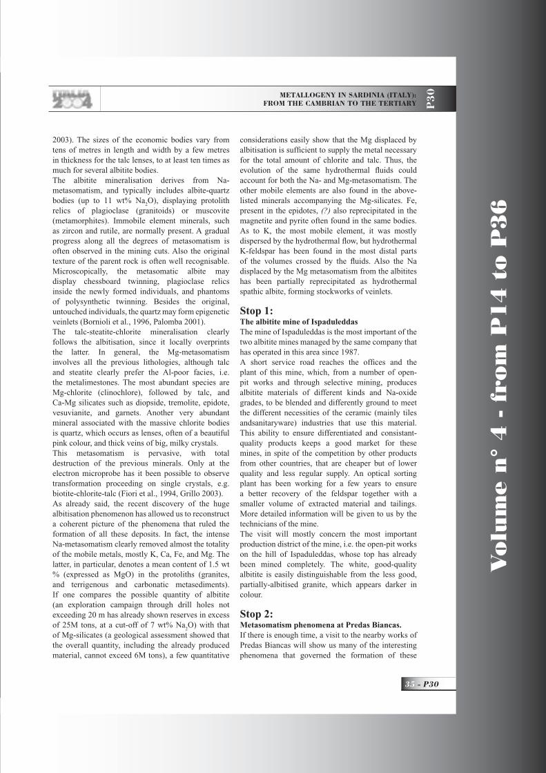
METALLOGENY IN SARDINIA (ITALY): FROM THE CAMBRIAN TO THE TERTIARY P
30
35 - P30
Vo
lum
e n
° 4
- f
rom
P1
4 t
o P
36
2003). The sizes of the economic bodies vary from tens of metres in length and width by a few metres in thickness for the talc lenses, to at least ten times as much for several albitite bodies.The albitite mineralisation derives from Na-metasomatism, and typically includes albite-quartz bodies (up to 11 wt% Na
2O), displaying protolith
relics of plagioclase (granitoids) or muscovite (metamorphites). Immobile element minerals, such as zircon and rutile, are normally present. A gradual progress along all the degrees of metasomatism is often observed in the mining cuts. Also the original texture of the parent rock is often well recognisable. Microscopically, the metasomatic albite may display chessboard twinning, plagioclase relics inside the newly formed individuals, and phantoms of polysynthetic twinning. Besides the original, untouched individuals, the quartz may form epigenetic veinlets (Bornioli et al., 1996, Palomba 2001).The talc-steatite-chlorite mineralisation clearly follows the albitisation, since it locally overprints the latter. In general, the Mg-metasomatism involves all the previous lithologies, although talc and steatite clearly prefer the Al-poor facies, i.e. the metalimestones. The most abundant species are Mg-chlorite (clinochlore), followed by talc, and Ca-Mg silicates such as diopside, tremolite, epidote, vesuvianite, and garnets. Another very abundant mineral associated with the massive chlorite bodies is quartz, which occurs as lenses, often of a beautiful pink colour, and thick veins of big, milky crystals. This metasomatism is pervasive, with total destruction of the previous minerals. Only at the electron microprobe has it been possible to observe transformation proceeding on single crystals, e.g. biotite-chlorite-talc (Fiori et al., 1994, Grillo 2003).As already said, the recent discovery of the huge albitisation phenomenon has allowed us to reconstruct a coherent picture of the phenomena that ruled the formation of all these deposits. In fact, the intense Na-metasomatism clearly removed almost the totality of the mobile metals, mostly K, Ca, Fe, and Mg. The latter, in particular, denotes a mean content of 1.5 wt % (expressed as MgO) in the protoliths (granites, and terrigenous and carbonatic metasediments). If one compares the possible quantity of albitite (an exploration campaign through drill holes not exceeding 20 m has already shown reserves in excess of 25M tons, at a cut-off of 7 wt% Na
2O) with that
of Mg-silicates (a geological assessment showed that the overall quantity, including the already produced material, cannot exceed 6M tons), a few quantitative
considerations easily show that the Mg displaced by albitisation is suffi cient to supply the metal necessary for the total amount of chlorite and talc. Thus, the evolution of the same hydrothermal fl uids could account for both the Na- and Mg-metasomatism. The other mobile elements are also found in the above-listed minerals accompanying the Mg-silicates. Fe, present in the epidotes, (?) also reprecipitated in the magnetite and pyrite often found in the same bodies. As to K, the most mobile element, it was mostly dispersed by the hydrothermal fl ow, but hydrothermal K-feldspar has been found in the most distal parts of the volumes crossed by the fl uids. Also the Na displaced by the Mg metasomatism from the albitites has been partially reprecipitated as hydrothermal spathic albite, forming stockworks of veinlets.
Stop 1: The albitite mine of IspaduleddasThe mine of Ispaduleddas is the most important of the two albitite mines managed by the same company that has operated in this area since 1987.A short service road reaches the offi ces and the plant of this mine, which, from a number of open-pit works and through selective mining, produces albitite materials of different kinds and Na-oxide grades, to be blended and differently ground to meet the different necessities of the ceramic (mainly tiles andsanitaryware) industries that use this material. This ability to ensure differentiated and consistant-quality products keeps a good market for these mines, in spite of the competition by other products from other countries, that are cheaper but of lower quality and less regular supply. An optical sorting plant has been working for a few years to ensure a better recovery of the feldspar together with a smaller volume of extracted material and tailings. More detailed information will be given to us by the technicians of the mine.The visit will mostly concern the most important production district of the mine, i.e. the open-pit works on the hill of Ispaduleddas, whose top has already been mined completely. The white, good-quality albitite is easily distinguishable from the less good, partially-albitised granite, which appears darker in colour.
Stop 2: Metasomatism phenomena at Predas Biancas. If there is enough time, a visit to the nearby works of Predas Biancas will show us many of the interesting phenomena that governed the formation of these
P30_R_OK 35 21-06-2004, 9:38:30
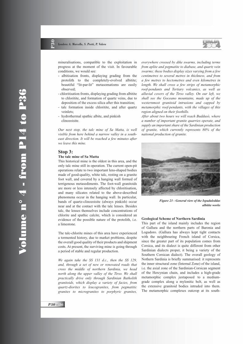
Vo
lum
e n
° 4
- f
rom
P1
4 t
o P
36
P30 - 36
Leaders: A. Marcello, S. Pretti, P. Valera
P3
0
mineralisations, compatible to the exploitation in progress at the moment of the visit. In favourable conditions, we would see:- albitisation fronts, displaying grading from the
protolith to the completely-evolved albitite; beautiful “lit-par-lit” metasomatisms are easily observed;
- chloritisation fronts, displaying grading from albitite to chloritite, and formation of quartz veins, due to deposition of the excess silica after this transition;
- talc formation inside chloritite, and after quartz veinlets;
- hydrothermal spathic albite, and pinkish clinozoisite.
Our next stop, the talc mine of Sa Matta, is well visible from here behind a narrow valley in a south-east direction. It will be reached a few minutes after we leave this mine.
Stop 3: The talc mine of Sa MattaThis historical mine is the oldest in this area, and the only talc mine still in operation. The current open-pit operations relate to two important lens-shaped bodies made of good-quality, white talc, resting on a granite foot wall, and covered by a hanging wall formed of terrigenous metasediments. The foot-wall granitoids are more or less intensely affected by chloritisation, and many silicates related to the above-described phenomena occur in the hanging wall. In particular, bands of quartz-clinozoisite (always pinkish) occur near and at the contact with the talc lenses. Besides talc, the lenses themselves include concentrations of chlorite and spathic calcite, which is considered an evidence of the possible nature of the protolith, i.e. a limestone.
The talc-chlorite mines of this area have experienced a tormented history, due to market problems, despite the overall good quality of their products and shipment costs. At present, the surviving mine is going through a period of stable and regular production.
We again take the SS 131 d.c., then the SS 129, and, through a set of new or renovated roads that cross the middle of northern Sardinia, we head north along the upper valley of the Tirso. We shall practically drive only through Sardinian Batholith granitoids, which display a variety of facies, from quartz-diorites to leucogranites, from pegmatitic granites to microgranites to porphyric granites,
everywhere crossed by dike swarms, including terms from aplite and pegmatite to diabase, and quartz vein swarms; these bodies display sizes varying from a few centimetres to several metres in thickness, and from a few metres to hectometres and even kilometres in length. We shall cross a few strips of metamorphic roof-pendants and Tertiary volcanics, as well as alluvial covers of the Tirso valley. On our left, we shall see the Goceano mountains, made up of the westernmost granitoid intrusions and capped by metamorphic roof-pendants, with the villages of this region aligned on their foothills.After about two hours we will reach Buddusò, where a number of important granite quarries operate, and supply an important share of the Sardinian production of granite, which currently represents 80% of the national production of granite.
Geological Scheme of Northern SardiniaThis part of the island mainly includes the region of Gallura and the northern parts of Baronia and Logudoro. (Gallura has always kept tight contacts with the neighbouring French island of Corsica, since the greater part of its population comes from Corsica, and its dialect is quite different from other Sardinian dialects proper, it being a variety of the Southern Corsican dialect). The overall geology of Nothern Sardinia is briefl y summarised: it represents the inner structural zone (Internal Zone) of the island, i.e. the axial zone of the Sardinian-Corsican segment of the Hercynian chain, and includes a high-grade metamorphic complex juxtaposed to a medium-grade complex along a mylonitic belt, as well as the extensive granitoid bodies intruded into them. The metamorphic complexes outcrop at its south-
Figure 23 - General view of the Ispaduleddas albitite works
P30_R_OK 36 21-06-2004, 9:39:04
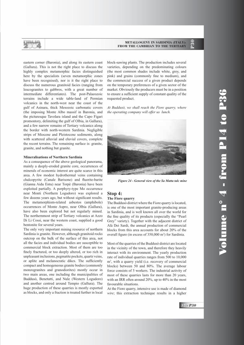
METALLOGENY IN SARDINIA (ITALY): FROM THE CAMBRIAN TO THE TERTIARY P
30
37 - P30
Vo
lum
e n
° 4
- f
rom
P1
4 t
o P
36
eastern corner (Baronia), and along its eastern coast (Gallura). This is not the right place to discuss the highly complex metamorphic facies distinguished here by the specialists (seven metamorphic zones have been recognised), nor is it the right place to discuss the numerous granitoid facies (ranging from leucogranites to gabbros, with a great number of intermediate differentiates). The post-Palaeozoic terrains include a wide table-land of Permian volcanics in the north-west near the coast of the gulf of Asinara, thick Mesozoic carbonatic covers (the imposing Monte Albo massif in Baronia, and the picturesque Tavolara island and the Capo Figari promontory, delimiting the gulf of Olbia, in Gallura), and a few narrow remains of Tertiary volcanics along the border with north-western Sardinia. Negligible strips of Miocene and Pleistocene sediments, along with scattered alluvial and eluvial covers, complete the recent terrains. The remaining surface is: granite, granite, and nothing but granite.
Mineralisations of Northern SardiniaAs a consequence of the above geological panorama, mainly a deeply-eroded granite core, occurrences of minerals of economic interest are quite scarce in this area. A few modest hydrothermal veins containing chalcopyrite (Canale Barisone) and fl uorite-barite (Gianna Aidu Entu) near Torpè (Baronia) have been exploited partially. A porphyry-type Mo occurrence near Monti (Northern Logudoro) was explored a few dozens years ago, but without signifi cant results. The metamorphism-related asbestos (amphibole) occurrences of Monte Aspro, near Olbia (Gallura), have also been explored but not regularly mined. The northernmost strip of Tertiary volcanics at Azzo Di Li Cossi, near the western coast, supplied a good bentonite for several years.The only very important mining resource of northern Sardinia is granite. However, although granitoid rocks outcrop on the bulk of the surface of this area, not all the facies and individual bodies are susceptible to commercial block extraction. Most of them are too fi nely fractured, or too deeply altered, or too rich in unpleasant inclusions, pegmatite pockets, quartz veins, or aplite and melanocratic dikes. The suffi ciently compact and homogeneous granite bodies (commonly monzogranites and granodiorites) mostly occur in two main areas, one including the municipalities of Buddusò, Benetutti, and Nule (Western Logudoro) and another centred around Tempio (Gallura). The huge production of these quarries is mostly exported as blocks, and only a fraction is treated further in local
block-sawing plants. The production includes several varieties, depending on the predominating colours (the most common shades include white, grey, and pink) and grains (commonly fi ne to medium), and the commercial success of a given product depends on the temporary preferences of a given sector of the market. Obviously the producers must be in a position to ensure a suffi cient supply of constant quality of the requested product.
At Buddusò, we shall reach the Fiore quarry, where the operating company will offer us lunch.
Stop 4: The Fiore quarryThe Buddusò district where the Fiore quarry is located, is one of the most important granite-producing areas in Sardinia, and is well known all over the world for the fi ne quality of its products (especially the “Pearl Grey” variety). Together with the adjacent district of Alà Dei Sardi, the annual production of commercial blocks from this area accounts for about 20% of the overall fi gure (in excess of 350,000 m3) for Sardinia.
Most of the quarries of the Buddusò district are located in the vicinity of the town, and therefore they heavily interact with its environment. The yearly production rate of individual quarries ranges from 500 to 10,000 m3, with a quarry yield (i.e. recovery of commercial blocks) between 50 and 80%. The average labour force consists of 5 workers. The industrial activity of most of these quarries lasts for more than 20 years, with an IRR often around 20%, up to 40% in the most favourable situations.At the Fiore quarry, intensive use is made of diamond wire; this extraction technique results in a higher
Figure 24 - General view of the Sa Matta talc mine
P30_R_OK 37 21-06-2004, 9:39:25

Vo
lum
e n
° 4
- f
rom
P1
4 t
o P
36
P30 - 38
Leaders: A. Marcello, S. Pretti, P. Valera
P3
0
recovery and a better quality of the blocks. In addition to this, the goal of an integral recovery is pursued by the operating company; through the benefi ciation of by-products, it aims at increasing the overall profi t, and at drastically reducing the environmental impact.
After this last visit we shall head north-east towards Olbia through a granitic landscape for about one hour. The town of Olbia, at the innermost portion of its gulf, is at present a modern town, intensely active with its important harbour and airport, plus a few industries, but its origin is very old (the name “Olbia” is Greek), and various ancient monuments scattered in its territory testify to its past. Here our party breaks up. We shall have spent fi ve days together, a very short time for a valid picture of the geology of Sardinia, whose complexity is quite exceptional compared to its size, and of its mining activity, which is also unusual in terms both of quantity and variety of mineral products, and of its length over history. Perhaps some of the participants will be attracted by these aspects, and will decide to return here to examine them in greater depth. Hope to see you again in Sardinia!
References Ardau C. & Rundeddu L., Environmental problems and industrial archaeology in the Iglesiente mining district. In Guide-book to the fi eld trips in Sardinia, WRI-10. Rendiconti Facoltà di Scienze dell’ Università di Cagliari, LXXI, 2,91-108, 2001.
Biddau R., Da Pelo S., Dadea C., The abandoned mining area of Montevecchio-Ingurtosu. In Guide-book to the fi eld trips in Sardinia, WRI-10. Rendiconti Facoltà di Scienze dell’ Università di Cagliari, LXXI, 2, 109-123, 2001.
Boni M., Parente G., Bechstadt Th, De Vivo B., Iannace A., Hydrothermal dolomites in SW Sardinia (Italy): evidence for a widespread late-Variscan fl uid fl ow event.
Sed. Geology, 131, 3-4, 2000.
Boni M., Muchez Ph. & Schneider J. Permo-Mesozoic multiple fl uid fl ow and ore deposits in sardinia: a comparison with Post-Variscan mineralisation of Western Europe. In Blundell D., Neubauer F.& von Quadt A. (eds), The timing and location of major ore deposits in an evolving orogen. Geological Society, London, Special Publications 206, 199-211, 2001
Bornioli R., Fadda S., Fiori M., Grillo S.M., Marini C., Genetic aspects of albitite deposits from Central Sardinia: mineralogical and geochemical evidence. Expl. And Min. Geol., %, 61-72, 1996.Botteri M., Guida alle Chiese medioevali di Sardegna. Chiarella Sassari Ed., 1-195, 1979.
Buosi M., Contini E., Enne R., Farci A., Garbarino C., Naitza S., Tocco S., Contributo alla conoscenza dei materiali delle discariche della miniera di Monteponi: i “Fanghi Rossi” dell’elettrolisi, caratterizzazione fi sico-geotecnica e chimico-mineralogica, defi nizione del potenziale inquinante e proposte per possibili interventi. Res. Ass. Min. Sarda, Anno CIV, 49-93, 1999.
Carmignani L., Oggiano G. & Pertusati C., Geological outlines of the Hercynian Basement of Sardinia. In Guide-book to the fi eld excursion B3 of the 16th General Meeting of the IMA “Petrology, geology, and ore deposits of the Palaeozoic basement of Sardinia”,
Fig 25 - Partial view of the Fiore quarry
P30_R_OK 38 25-05-2004, 16:50:16
METALLOGENY IN SARDINIA (ITALY): FROM THE CAMBRIAN TO THE TERTIARY P
30
39 - P30
Vo
lum
e n
° 4
- f
rom
P1
4 t
o P
36
9-29, 1994.
Carmignani L., Oggiano G. & Pertusati C., Cambrian-Ordovician Stratigraphy, Sardinian Unconformity, and Hercynian Tectonics in the external zone. In Guide-book to the fi eld excursion B3 of the 16th General Meeting of the IMA “Petrology, geology, and ore deposits of the Palaeozoic basement of Sardinia”,47-54, 1994.
Cherchi M.A., Montadert L. Il sistema di rifting Oligo-Miocenico del Mediterraneo occidentale e le sue conseguenze Paleogeografi che sul Terziario Sardo. Mem. Soc. Geol. Ital, 24, 387-400, 1982.
Coulon C., Le volcanism calc-alcalin Cénozoique de Sardaigne (Italie): Pétrographie, géochemie, et genesè des laves andesitiques et des ignimbrites: Signifi cation géodinamique. Thèse, Universitté de Droit, D’Economie et des Sciences D’Aix, Marseille. 1977. Dessì R., Fiori m., Garbarino C., Grillo S.M., Marcello A., Pretti S., Risorse minerarie associate alle vulcaniti terziarie della Sardegna. Atti del Congresso Internazionale per il Centenario dell’associazione Mineraria sarda 1896-1996. “Sardegna Mineraria dal II al II Millennio”, III, 115-135.
Fadda S., Fiori M., Pretti S., The sandstone-hosted Pb occurrence of Rio Pischinappiu (Sardinia, Italy): a Pb-carbonate end-member. Ore Geology Reviews 12, 355-377, 1998.
Fadda S., Fiori M. & Grillo S.M., Economic-grade potassic alteration in the volcanic-hosted epithermal system of Monti Ferru Western Sarinia Italy. Proceeding of the seventh biennal SGA Meeting “Mineral Exploration and Sustainable Development”, 1, 473-476, 2003.
Fiori M., Pretti S. & Uras I., L’oro nella metallogenesi sarda. Prime osservazioni. L’Industria Mineraria , 4, 1-8, 1988.
Fiori M., Grillo S.M., Marcello A., Pretti S., Mineral resources of the Oligocene-Miocene volcanic district of Monastir-Furtei (southern Sardinia). Mem. Soc. Geol. It. 48, 725-730, 1994.
Fiori M., Garbarino C., Grillo S.M., Pretti S. Relazioni genetiche tra le mineralizzazioni ad albite e quelle a clorite-talco della Sardegna Centrale. Atti
della giornata di studio in ricordo di S. zucchetti, 131-137, 1994.
Fiori M., Grillo S.M., Matzuzzi C. Mineralization and alteration patterns in some drill-holes of the epithermal gold mineralisation of S.Miali area, Furtei, sardinia, Italy. Proceeding of the seventh biennal SGA Meeting “Mineral Exploration and Sustainable Development”, 1, 477-480, 2003.
Fiori M., Granizio F., Grillo S.M., Simeone R., Porphyry and Epithermal systems near Siliqua, sardinia, Italy. Proceeding of the seventh biennal SGA Meeting “Mineral Exploration and Sustainable Development”, 1, 267-270, 2003.
Frezzotti M.L., Ghezzo C., Stefanini B., The Calabona intrusive complex (Sardinia, Italy): evidence for a copper system. Economic Geology, 87, 425-436, 1992.Grillo S.M., The talc mineralization in Central Sardinia Su Venosu mine. IGCP 443 - Magnesite and Talc-Geological and Environmental Correlations. In press.
Garbarino C., Grillo S.M., Marcello A., Pretti S., Uras I. & Fiori M,. First data on Tertiary epithermal occurrences in Sardinia. Proceeding Symp. “Brazil Gold 1991”, 143-150, 1991.
Maccioni l., Marchi M., Padalino G., Pretti S. Preliminary geochemical exploration in semiarid climate: the case of a porphyry type occurrence in Sardinia (Italy).Journ. of Geochemical Expl. 42, 261-272.
Palomba P. Geological, mineralogical, geochemical features and genesis of the albitite deposits of Central Sardinia (Italy). In Guide-book to the fi eld trips in Sardinia, WRI-10. Rendiconti Facoltà di Scienze dell’ Università di Cagliari, LXXI, 2, 35-57, 2001.
Ruggieri G., Lattanzi P., Luxoro S., Dessi R., Benvenuti M., Tanelli G. Geology, Mineralogy, and Fluid inclusion data of Furtei high-sulph. Gold deposit, sard, Italy. Econ. Geology 92, 1-20.
Marcello A., Pretti S., Salvadori I., Introduction to the Minerogenesis and the Economic Geology of Sardinia. In Guide-book to the fi eld excursion B3. The 16th General Meeting of the IMA “Petrology, geology, and ore deposits of the Palaeozoic basement
P30_R_OK 39 25-05-2004, 16:50:18

Vo
lum
e n
° 4
- f
rom
P1
4 t
o P
36
P30 - 40
Leaders: A. Marcello, S. Pretti, P. Valera
P3
0
of Sardinia”,37-43, 1994.
Marcello A., Pretti S., Salvadori I, Pb-Zn Mineralizations in the Cambrian Carbonatic Rocks S.Giovanni Mine-Iglesiente. In Guide-book to the fi eld excursion B3. The 16th General Meeting of the IMA “Petrology, geology, and ore deposits of the Palaeozoic basement of Sardinia”,55-60, 1994.
Oggiano G. & Di Pisa A., Introduction to the Sardinia geologic evolution. In Guide-book to the fi eld trips in Sardinia, WRI-10. Rendiconti Facoltà di Scienze dell’ Università di Cagliari, LXXI, 2, 5-11, 2001.
Oggiano G. & Mameli P., The bauxite of North-Western Sardinia. . In Guide-book to the fi eld trips in Sardinia, WRI-10. Rendiconti Facoltà di Scienze dell’ Università di Cagliari, LXXI, 2, 59-73, 2001.
Palomba M., Padalino G. & Marchi M., Industrial mineral occurrences related to Cenozoic volcanic rocks of Sardinia (Italy). Proceeding of the seventh biennal SGA Meeting “Mineral Exploration and Sustainable Development”, 1, 919-922, 2003.
Simeone R. & Simmons S.F. Mineralogical and fl uid inclusion studies of low-sulphidation epithermal veins at Osilo (Sardinia,Iitaly).Min. Deposita , 34, 705-717, 1999.
Società di Monteponi, Centenario 1850-1950, Vincenzo Bona Ed., 1-296, 1952.
Zuffardi P., Giacimentologia e Prospezione Mineraria. Pitagora Editrice Bologna, 1-584, 1982.
P30_R_OK 40 25-05-2004, 16:50:20

Back Cover: Field trip itinerary
P30_copertina_R_OK E 25-05-2004, 16:37:56

Edited by APAT
FIELD TRIP MAP
32nd
IN
TE
RN
AT
ION
AL
GE
OLO
GIC
AL
CO
NG
RE
SS
P30_copertina_R_OK B 25-05-2004, 16:38:38


![MODBUS Protocol for MiCOM P30 Series - … · MODBUS Protocol for MiCOM P30 Series [ [[ [Substation Protocols ]]]] 3 Mbm0100b.doc Schneider Electric Energy MiCOM P30, MODBUS](https://static.fdocuments.in/doc/165x107/5b97ad7d09d3f2dc628b49b6/modbus-protocol-for-micom-p30-series-modbus-protocol-for-micom-p30-series.jpg)