Mercury Activities Tracking Memo 4-3-15 (working draft)
46
To: Water Resources Association of Yolo County (Yolo WRA) Mercury Subcommittee Stephen McCord, Ph.D., P.E. 759 Bianco Court Davis, CA 95616 (530) 220-3165 [email protected] Date: April 3, 2015 WORKING DRAFT Subject: Summary of mercury-related activities relevant to the Yolo WRA Overview Mercury-related activities relevant to the Yolo WRA are described in this memo, as shown in Table 1. This memo is a “working draft” updated as relevant information is received. Needs for near-term effort by the Yolo WRA are highlighted. All of the activities are shown collectively on a regional map in Figure 1. Regulatory Context Several water quality regulations promulgated by the Central Valley Regional Water Quality Control Board (Regional Board) currently drive mercury controls in Yolo County and its Cache Creek and Putah Creek watersheds: • USEPA approved the Basin Plan Amendment to control mercury in Clear Lake on September 26, 2003. • A Total Maximum Daily Load (TMDL) for mercury in the Cache Creek watershed (including Clear Lake, Harley Gulch, Bear Creek and Sulphur Creek upstream of Yolo County) approved on October 21, 2005. • A TMDL for Methylmercury (MeHg) and Total Mercury in the Sacramento – San Joaquin Delta and Yolo Bypass approved by the US Environmental Protection Agency on October 20, 2011. Several additional water bodies within Yolo County and its watersheds are listed as mercury- impaired on the state’s 2010 303(d) list. These regulations, plus other general water quality interests, are driving activities to address mercury contamination in the region. Contributors This work was done under contract with the Yolo WRA in collaboration with its Mercury Subcommittee. Primary contacts are Tim O’Halloran (Yolo County Flood Control and Water Conservation District) and Elisa Sabatini (County of Yolo), Bob Schneider (Tuleyome), and Ann Brice (Yolo Basin Foundation).
-
Upload
nguyenquynh -
Category
Documents
-
view
215 -
download
0
Transcript of Mercury Activities Tracking Memo 4-3-15 (working draft)
To: Water Resources Association of Yolo County (Yolo WRA) Mercury Subcommittee
Stephen McCord, Ph.D., P.E.
759 Bianco Court Davis, CA 95616
(530) 220-3165 [email protected]
Date: April 3, 2015 WORKING DRAFT
Subject: Summary of mercury-related activities relevant to the Yolo WRA
Overview Mercury-related activities relevant to the Yolo WRA are described in this memo, as shown in Table 1. This memo is a “working draft” updated as relevant information is received. Needs for near-term effort by the Yolo WRA are highlighted. All of the activities are shown collectively on a regional map in Figure 1.
Regulatory Context Several water quality regulations promulgated by the Central Valley Regional Water Quality Control Board (Regional Board) currently drive mercury controls in Yolo County and its Cache Creek and Putah Creek watersheds:
• USEPA approved the Basin Plan Amendment to control mercury in Clear Lake on September 26, 2003.
• A Total Maximum Daily Load (TMDL) for mercury in the Cache Creek watershed (including Clear Lake, Harley Gulch, Bear Creek and Sulphur Creek upstream of Yolo County) approved on October 21, 2005.
• A TMDL for Methylmercury (MeHg) and Total Mercury in the Sacramento – San Joaquin Delta and Yolo Bypass approved by the US Environmental Protection Agency on October 20, 2011.
Several additional water bodies within Yolo County and its watersheds are listed as mercury-impaired on the state’s 2010 303(d) list. These regulations, plus other general water quality interests, are driving activities to address mercury contamination in the region.
Contributors This work was done under contract with the Yolo WRA in collaboration with its Mercury Subcommittee. Primary contacts are Tim O’Halloran (Yolo County Flood Control and Water Conservation District) and Elisa Sabatini (County of Yolo), Bob Schneider (Tuleyome), and Ann Brice (Yolo Basin Foundation).

Yolo WRA Hg Subcomm. April 3, 2015 WORKING DRAFT Page 2
Table 1. Mercury-related Activities Described in this Memo.
# Title Notes Interest Suggested Engagement and Action Items Page1 Sulphur Bank Mercury Mine Feasibility
AssessmentLow Track USEPA’s planning process in spring 2015. 4
2 Bear Creek Riparian Restoration Project a Low Support project proponents in proposals for funding. 63 Harley Gulch Biota Monitoring Study a Low Contact USEPA Region IX staff for update in spring 2015. 74 Cache Creek Site Discovery Report c Low Track the CERCLA status of mine sites identified in the report in spring 2015. 95 BLM Mercury Mines Site Cleanups a Mid Check on status of EE/CA reports in spring 2015. Ask Jim Weigand about progress on prioritization study and how the WRA
could participate. Track BLM clean up actions and associated monitoring of effectiveness. 10
6 Corona and Twin Peaks Mines Cleanup Mid Track project progress in Hg Subcommittee meetings. Encourage similar cleanups and pilot treatments of discharges on other private lands.
13
7 Cache Creek, Bear Creek, Sulphur Creek and Harley Gulch Mercury TMDLs
a Mid Contact Janis Cooke in spring 2015 to inquire about the program review process. 15
8 Statewide Mercury Control Program Mid Evaluate potential effects of the TMDL regulations on reservoir operations in the Cache and Putah Creeks watersheds. Coordinate with US Bureau of Reclamation staff regarding mercury monitoring and/or modeling of Lakes Berryessa and Solano. Meet with Regional Board staff through their public outreach efforts.
18
9 Cache Creek Area Plan Mercury Monitoring
a Low Track state and regional mercury monitoring activities and suggest future cost sharing. 22
10 Cache Creek Mapping and Sampling Project
c N/A None – the project is closed. 24
11 Cache Creek Setting Basin Mercury Studies
b Mid Respond to DWR and contractor (UC Davis and USGS) questions/requests as they arise. Review study reports in summer or fall 2015. Coordinate with USACOE on flood risk management studies. Identify and evaluate feasible options for sediment excavation of the CCSB to maintain settling capacity, compare alternatives, discuss potential mercury effects with scientists, and quantify potential change from baseline.
25
12 Central Valley Flood Protection Plan Mid Evaluate potential effects of Regional Flood Management Plan on MeHg regulatory requirements, and vice-versa. 2913 Yolo Bypass Fisheries Enhancement
ProjectsMid Support Yolo County interests in evaluating mercury effects of BDCP. Request local participation in simulation modeling
and an adaptive management process for proposed projects. Integrated project to address BiOps.31
14 Lower Putah Creek Restoration Mid Support the development and review of CEQA documents and other project descriptions (when available) for County interests.
34
15 Yolo Bypass Wetland MeHg Control Studies
b Mid Review ongoing studies conducted by CDFW focused on permanent ponds. 36
16 Delta MeHg TMDL Mercury Exposure Reduction Program
b Mid Track early implementation of the MERP workplan in spring 2015, and comment as warranted through the Steering Committee.
39
17 Clear Lake Mercury TMDL Low Track updates and projects driven (or constrained) by the regulation in spring 2015. 4218 Lake Solano Mercury Monitoring Low Continue to offer technical support. 4419 USEPA-led Agency Cooperation a Mid Participate in future meetings to address Hg in the watershed. Suggest that agencies combine with the Hg Subcommittee.
Report back to Hg Subcommittee. Support an assessment coalition grant proposal by the Westside IRWM Coordinating Committee.
45
NOTES:a The activity is driven in part by the Cache Creek, Bear Creek, Sulphur Creek and Harley Gulch Hg TMDL.b The activity is driven in part by the Delta MeHg TMDL.c Project is closed.
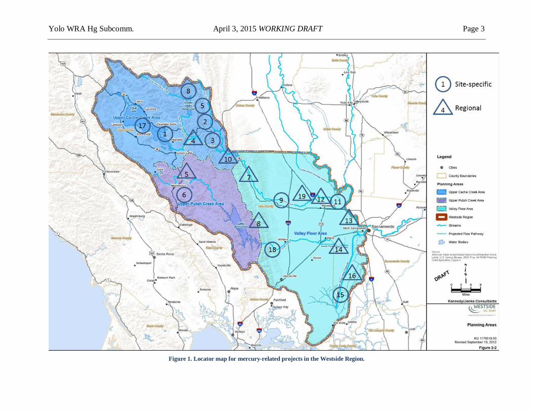
Yolo WRA Hg Subcomm. April 3, 2015 WORKING DRAFT Page 3
Figure 1. Locator map for mercury-related projects in the Westside Region.
Yolo WRA Hg Subcomm. April 3, 2015 WORKING DRAFT Page 4
1. Sulphur Bank Mercury Mine Feasibility Assessment The current Feasibility Assessment continues decades of study by USEPA to evaluate feasible options for long-term remediation of the mine site (a Superfund site). The purpose of the assessment is to develop a clear characterization of cleanup options, to support making a decision to implement a long-term cleanup solution.
Description / Scope The mine/pit and lake sediments are being addressed separately. First, USEPA is currently working to develop a Proposed Plan for cleanup of the terrestrial mine site and the Herman Impoundment at the Sulphur Bank Mine. The Plan, due by late 2013, would include USEPA's preferred alternative to conduct a cleanup protective of human health and the environment. It will also summarize all of the options considered. Second, USEPA will construct two test "caps" placing gravel and sand over mercury-contaminated sediments in Clear Lake near the mine in October 2012. These caps will be monitored for through 2015 to assess how well they could perform as a long-term cleanup solution to address mercury in sediments.
Contacts • Greg Reller, Burleson Consulting • Gary Riley, USEPA, 415-972-3003 • Karola Kennedy, Environmental Coordinator, Elem Indian Colony • Janis Cooke, Regional Water Board
Relevance to Yolo WRA Millions have been spent studying this site and planning and undertaking remediation actions. This extensive body of research and experience could be useful for other sites. If any candidate mine sites identified in the Cache Creek Site Discovery Report (Activity #4) are pursued, one potential template for action is the Sulphur Bank Mercury Mine.
Status 8/27/12: A formal public comment period and public hearing to receive comment on the Proposed Plan will take place around late 2013.
6/27/13: Gary Riley replied that USEPA has installed and will be monitoring two pilot sand & gravel caps through Jan 2015. They continue to discuss remediation options for acidic water seeping through the waste rock pile into the lake. 6/2/14: USEPA is waiting on its feasibility study’s results to determine the next plan of action. USEPA is also working with Elem Indian Colony to implement a Community Involvement Plan and conduct interviews associated with that.
12/22/14: Karola Kennedy provided the two most recent stormwater and ground water monitoring reports for the mine, both for the 2011-2012 period. Stormwater runoff from the mine

Yolo WRA Hg Subcomm. April 3, 2015 WORKING DRAFT Page 5
waste-impacted areas continues to be acidic (<4.5) and have elevated nickel and mercury concentrations (up to 30x and 100x the CA Toxics Rule limits, respectively). Groundwater flow rates have not changed significantly over the past decade. Mercury loads to the lake via groundwater averaged 20 lb/yr, which remains significantly greater than the TMDL allocation of 1.1 lb/yr. 1/7/15: Janis noted that USEPA and the State agencies (DTSC and CVRWQCB) are continuing to discuss remediation options for Operable Unit 1, the terrestrial mine site. DTSC has proposed some new ideas. USEPA is considering preparation of an addendum to the 2006 Record of Decision. 3/13/15: The 2014 groundwater and stormwater data reports should be produced this spring. E2 Engineering, who is ACE’s new contracted firm to do the field work at the mine, has just completed core sampling on the caps at 6, 12, 18, and 24 months and analyzed for biota, metals and nutrients. Results are due by fall 2015. EPA is considering preparing an addendum to the 2006 RI/FS for the site to address DTSC questions about EPA's model of pit inflows and outflows. Given the long time to prepare RI/FS-type documents, the next document release may not be until 2016.
Suggested Engagement and Action Items Track USEPA’s planning process in spring 2015.

Yolo WRA Hg Subcomm. April 3, 2015 WORKING DRAFT Page 6
2. Bear Creek Riparian Restoration Project The purpose of the overall project is to restore Bear Creek’s riparian condition for bank stability and habitat enhancement. Colusa County Resource Conservation District (RCD) and U.S. Bureau of Land Management received a 319(h) planning grant to prepare for stabilization and restoration of mercury-laden streambank material that is eroding into Bear Creek. Shovel-ready design plans and environmental documentation were to be completed by 2013. However, the work stalled when regulators required characterization of the material before stabilization. Additional work to reduce sediment erosion in the watershed stalled when the Regional Board management decided funds should be spent on mine sites in the watershed rather than on the major source areas of erodible sediments.
Description / Scope This project will build on the work of the Colusa RCD and Pacific Watershed Associates that designed a project to improve water quality in Sulphur Creek and downstream. That grant-funded project did not include funds required later for Hg characterization. This project will: 1) characterize mercury as required to enable erosion control work, 2) hydrologically disconnect up to 23 miles of road networks that are currently contributing runoff and contaminated sediment to downstream waters, 3) stabilize 2000 feet of eroding stream banks that are over-steepened and delivering methylmercury contaminated sediment into the stream system, 4) treat 115 road-related erosion and sediment delivery sites, and 5) stabilize three major valley bottom headcuts that are resulting in serious valley fill erosion along the main stem Sulphur Creek, desiccating alkali wet-meadows and lowering the water table. By implementing this project a total of 23,800 cubic yards of contaminated sediment containing 7.0 kg of mercury will be prevented from being eroded and delivered to the stream system and to downstream water bodies.
Contacts • Craig Thomsen, UC Davis • Bob Schneider, Tuleyome
Relevance to Yolo WRA Although the project site is in Colusa County, Bear Creek drains into Cache Creek. If grant funding is not available for addressing mercury concerns at this site, similar beneficial projects in the county could also get stalled.
Status 8/24/12: A proposal was submitted in August 2012 to the Westside IRWM Group.
12/12/12: Tuleyome submitted a $900,000 proposal to the Westside IRWMP for the entire scope. 5/13/13: The Westside IRWMP did not keep this project in the final list of proposed projects.
Suggested Engagement and Action Items Support project proponents in proposals for funding.

Yolo WRA Hg Subcomm. April 3, 2015 WORKING DRAFT Page 7
3. Harley Gulch Biota Monitoring Study USGS researchers monitored mercury in water and biota in the gulch downstream of the Abbott-Turkey Run Mine site. The purpose of the study was to monitor before and after the site cleanup in 2007 to evaluate the benefits of that action.
Description / Scope USGS sampled Harley Gulch four times between 2007 and 2011, at 6-18 sites from the Hwy 20 wetlands to Cache Creek, to evaluate impact of mine and natural sources of mercury on water, sediment, and biota in Harley Gulch downstream of a cleanup action at the Abbott and Turkey Run Mines. Compared to the baseline data in 2007 (while mine site remediation was underway), most sites showed marked decreases in concentrations in invertebrates and amphibians. Highest levels continued to be found at the first site downstream of the wetlands and downstream of a natural saline spring. Mercury concentrations remained substantially elevated in 2008 compared to the reference site and other sites in Northern California unaffected by historical Hg mining. Suggested citation (most recent publication):
Rytuba, J.J., Hothem, R.L., Brussee, B.E., and Goldstein, D.N., 2011, Impact of mine and natural sources of mercury on water, sediment, and biota in Harley Gulch adjacent to the Abbott-Turkey Run mine, Lake County, California: U.S. Geological Survey Open File Report 2011-1265, 105 pp. http://pubs.usgs.gov/of/2011/1265/.
Contacts • Jim Rytuba, Daniel Goldstein, and Roger Hothem, USGS • Janis Cooke, Regional Water Quality Control Board • Kim Hoang, USEPA Region IX Superfund program
Relevance to Yolo WRA The fact that mercury concentrations in biota decreased after remediation is certainly promising, but the fact that those levels remain elevated is troubling. These findings encourage project success elsewhere to be weighed against performance of actions (e.g., cleaned up mine site) rather than against desired effects (e.g., mercury body burden in biota below some threshold).
Status 8/27/12: This study has been completed. There is some funding under NRDA, and BLM, under Jim Weigand (CASO/CA/BLM/DOI) and perhaps US Fish & Wildlife Service, for future potential work.
12/5/12: Regional Board and El Paso have sampled in the wetland downstream of Abbot and Turkey Run. No decisions have been made as to whether the wetlands should be remediated and if so, how. 5/13/13: US Fish & Wildlife Service requested that USEPA conduct a “site assessment”, which is a basic desktop study (no monitoring) triggered by the USGS data (that is, the USEPA-led mine site cleanup was implemented, yet mercury high levels in biota remain high). USEPA’s
Yolo WRA Hg Subcomm. April 3, 2015 WORKING DRAFT Page 8
efforts could end there, or their findings could trigger some future monitoring, but there is nothing planned at this point.
1/22/14: USEPA is completing a preliminary assessment of the Abbott and Turkey Run mines on Harley Gulch in summer 2014. If the data from sampling conducted by Kinder Morgan compels them, they will move forward on a site investigation, in which they will sample on and off the mine site to assess potential releases from the site. As for the biota study, USGS has not provided an update. 2/27/14: Regional Board staff is evaluating emergency response actions at Abbott-Turkey Run Mine (started by EPA, picked up by PRP Kindall-Morgan); 13267 Orders for (1) maintenance & monitoring of “cintered” waste rock cap, (2) investigation of wetland south of Hwy. 20. Staff asked the PRP (who refused) to investigate Hg tailings in sediment delta at the gulch confluence with Cache Creek.
6/3/14: Biota mercury downstream has not decreased since the mine site was cleaned up. USEPA will likely conduct a Site Investigation (SI), which would also address Harley Gulch. The results of that SI may result in the site being re-listed as a CERCLA site. 12/22/14: USEPA contractor Weston conducted a Preliminary Assessment for Abbott-Turkey Run, which also addressed Harley Gulch. The PA may result in the site being re-listed as a CERCLA site.
Suggested Engagement and Action Items Contact USEPA Region IX staff for updates in spring 2015.

Yolo WRA Hg Subcomm. April 3, 2015 WORKING DRAFT Page 9
4. Cache Creek Site Discovery Report The Department of Toxic Substances Control conducted a 2009-2011 study of the Cache Creek watershed. The purpose of the study was to assess possible Superfund sites.
Description / Scope This project was funded by a USEPA Preliminary Assessment / Site Discovery Grant to the Department of Toxic Substances Control, 2009-2011.
Contacts The report was prepared by DTSC staff Tim Miles and Tom Olson (Hazardous Substances Scientists) and Kristin Prado (Student Assistant). The report summarizes available information on mercury contamination throughout the watershed to identify mine sites perceived to be contamination sources. The report can be downloaded at http://www.envirostor.dtsc.ca.gov/public/profile_report.asp?global_id=60001635.
Relevance to Yolo WRA Mines sites identified as sources (or potential ones) will be evaluated further by DTSC as Site Screening Assessments. Those deemed significant may then fall under CERCLA for detailed evaluation and cleanup. Nine sites were selected for further evaluation, including seven mines in the Sulphur Creek watershed, Utopia Mine along Clear Lake, and the Cache Creek Settling Basin (the only site in Yolo County). Specific recommendations for addressing the mercury problem were beyond the scope of this project.
Status 8/27/12: DTSC’s work has been completed. USEPA must decide to pursue clean up actions under CERCLA. CERCLA status can be tracked for the individual mine sites at http://cumulis.epa.gov/supercpad/cursites/srchsites.cfm
5/13/13: Elgin Mine in the Sulphur Creek watershed is undergoing a Preliminary Assessment by BLM.
1/22/14: USEPA will be completing preliminary assessments (PAs) of the Abbott/Turkey Run, Elgin, Reed, and Harrison mines in the Harley Gulch, Sulphur Creek, and Davis Creek watersheds by summer 2014. Based on the PAs’ findings, they may move forward with site investigations (SIs) on some of the individual mine sites. Likewise, USEPA may move forward with an SI for the Cache Creek Settling Basin later this year. 6/3/14: USEPA is still finalizing its PAs. The delay pertains to a new online database, which has been malfunctioning. 12/11/14: EPA provided 8 PAs. See activity #19 for more information.
Suggested Engagement and Action Items Track the CERCLA status of mine sites identified in the report in spring 2015.

Yolo WRA Hg Subcomm. April 3, 2015 WORKING DRAFT Page 10
5. BLM Mercury Mines Site Cleanups The US Bureau of Land Management’s (BLM) Ukiah Field Office is evaluating cleanup options for several sites on BLM lands: Rathburn and Rathburn-Petray Mines on Walker Ridge in the Sulphur Creek Mining District (Colusa Co.); and Chicago and Research Mercury Mines and Helen Mine located near Middletown (Lake Co.). BLM’s purpose with the reports cited is to investigate and prioritize alternatives for future cleanup action.
Description / Scope On abandoned mercury mines sites, mercury-bearing material is exposed in cuts, slopes, open pits, mine waste piles, brick retorts, and storm water retention ponds. Mineral springs may be ongoing sources of mercury.
For the Rathburn and Rathburn-Petray Mines (http://www.blm.gov/ca/st/en/prog/aml/project_page/rathburn_petray.html) BLM has proposed Comprehensive Environmental Response, Compliance and Liability Act (CERCLA) actions including compilation of a Potentially Responsible Party search, Removal Site Inspection and Engineering Evaluation/ Cost Analysis reports in order to conduct removal and disposal operations on approximately 15,000 cubic yards of mercury calcines and related mine wastes from the mercury retort site. This CERCLA removal action is being done piecemeal as funds are available. The east pit is being studied, North Petray pit is being designed, and nothing is occurring on private land for the South Petray pit. BLM is developing a removal action at Clyde Mine on Walker Ridge.
The Chicago and Research mines site (http://www.blm.gov/ca/st/en/fo/ukiah/chicago_research_mercury.html) is located in the Dry Creek Mining District, a tributary of Upper Putah Creek southwest of Middletown. The Chicago and Research Hg mines produced only a small amount of mercury, less than 30 flasks. BLM publicized a draft Engineering Evaluation and Cost Analysis (EE/CA) in late 2011 for capping excavation and consolidation of mercury calcine mill waste piles. No follow-up work (to perform the cleanup action) has been publicized.
The Helen Mine (http://www.blm.gov/ca/st/en/fo/ukiah/helen_mercury_mine.html) is also located in the Dry Creek Mining District on 35 acres that is a mix of private property and land managed by BLM. The site includes five main site features: a northern tailings pile, middle tailings pile, southern disturbed area, and storage tank and retort areas. In sum there are 6,800 cubic yards of contaminated materials. BLM produced a “Draft final” Engineering Evaluation and Cost Analysis (EE/CA) in July 2010, which proposed a $1.7 million clean-up alternative. No follow-up work (to perform the cleanup action) has been publicized. A USGS report on the Chicago/Research and Helen Mines can be downloaded at http://pubs.usgs.gov/of/2008/1382/.
Contacts • Jim Weigand, Rich Burns and Molly Nilsson, BLM, Ukiah Field Office • Jeff Huggins, Regional Board • Karen Jurist, USEPA Region IX
Yolo WRA Hg Subcomm. April 3, 2015 WORKING DRAFT Page 11
Relevance to Yolo WRA Surface water runoff during storm events erodes waste and tailings piles, overflows retention ponds, and transports mercury-laden sediment into drainage swales and unnamed tributaries of Bear Creek. Mine waste present at the mine sites contains mercury that may pose a threat to human health due to exposure (dermal, ingestion, and inhalation) through recreation (hiking, camping, fishing, and hunting) or work at the mine sites. Mercury contamination has been found in the water, sediment and biota downstream of the sites.
Similar work may occur at Clyde Mine, which is also in the Sulphur Creek Mining District on Walker Ridge.
Status 10/5/12: Gary Sharpe (BLM – Ukiah Field Office) will present this project at the 11/13/12 DTMC meeting. 11/13/12: Gary Sharpe (BLM – Ukiah Field Office) presented at the 11/13/12 DTMC meeting. The presentation can be downloaded at http://www.sacriver.org/files/201211_1_RathburnAbandonedMercuryMine.pdf.
12/11/12: Over the past few years Regional Board staff members Jeff Huggins and Victor Izzo have reviewed characterization and closure plans for several mines in the Sulphur Creek Mining District and for Rathburn-Petray Mine. BLM has implemented a portion of the closure at Rathburn and work may begin in the near future for some of the mines in the lower portion of Sulphur Creek Mining District (around Wilbur Hot Spring) on BLM and private lands. Homestake Mining Company is anticipated to “voluntarily” undertake these cleanup actions.
5/13/13: No real progress seems to have been made recently. 9/26/13: BLM’s Jim Weigand is interested in a watershed monitoring, assessment and prioritization study. 2/27/14: BLM is also involved since 2007 in the A-TR cleanup action with co-trustees USFWS & CDFW via CERCLA’s NRDA habitat restoration. The Preliminary Site Investigation is waiting on an evaluation of the cleanup. Rathburn-Petray phase 1 study is now completed. The EE/CA was completed in May 2013 for Chicago/Research mines. Still working at Clyde Mine. 6/3/14: BLM’s Gary Sharpe has retired, replaced by Molly Nilsson who is still getting up to speed on BLM projects. No updates on the Abbott-Turkey Run cleanup action, Chicago/ Research mines, or Clyde Mine. Molly is planning to work on Rathburn-Petray phase 2 erosion control and investigating Helen Mine. USEPA will likely take lead in A-TR, Elgin, Reed, Harris; doing SI to determine if listing CCSB & A-TR.
12/24/14: Updates from Molly on active project sites only:
• Rathburn: Design plans, due by the end of January 2015, call for rerouting runoff from waste rock piles to existing and new onsite sediment basins. Rolling dips will be constructed closer to the edge of the mine’s steep slopes, to slow water velocity. A vegetation study was completed in Fall 2014 to determine the most efficient method of revegetation in the serpentine soils of the mine, focusing on the steep slopes that currently have minimal vegetation. Pending available budget, construction will be implemented in 2015.

Yolo WRA Hg Subcomm. April 3, 2015 WORKING DRAFT Page 12
• Helen: Continuing mine site maintenance addressing recent heavy rain impacts. • Chicago and Research: Seeking funding. Action memo and reclamation activities would
be next steps. 3/23/15: (1) The plans for the next phase of rehabilitation at Rathburn have been completed. Construction for that will most likely happen in 2016. (2) The Helen mine held up well from the past rain storms. Only maintenance work is needed to remove material one of the sediment ponds and some of the drainages. (3) The Chicago and Research are also holding up, but BLM is still unsure how to go about reclamation of those mines. Once they have a source of funding, they will go ahead with the action memo.
Suggested Engagement and Action Items Check on status of EE/CA reports in spring 2015. Ask Jim Weigand and Molly Nilsson about progress on prioritization study and how the WRA could participate. Track BLM clean up actions and associated monitoring of effectiveness.

Yolo WRA Hg Subcomm. April 3, 2015 WORKING DRAFT Page 13
6. Corona and Twin Peaks Mines Cleanup Tuleyome is heading up a project to cleanup three abandoned mercury mines in the James Creek watershed tributary to Lake Berryessa. This project could serve as a model for cleanup of other abandoned mercury mine sites on private property in the Inner Coast Range.
Description / Scope Funds from the Ecosystem Restoration Program, administered by the Department of Fish and Game, are supporting a three-year project to clean up the landscape and drainage from three abandoned mercury mines in the Inner Coast Range. The project team, led by Tuleyome, includes technical and legal experts to address the multiple facets of the project. Stakeholders include federal, state and local agencies, and other interest groups. State funds are going through a non-profit to clean up private property (a Good Samaritan) for public benefits. The 2012-2015 project will treat adit drainages, address physical hazards, and stabilize erosive mine waste piles in tributaries to James Creek, which is tributary to Pope Creek, which is a major tributary to Lake Berryessa.
Contacts • Stephen McCord, MEI • Bob Schneider and Sara Husby-Good, Tuleyome
Relevance to Yolo WRA The project site is in the Putah Creek watershed, upstream of mercury or nickel impairments in James Creek, Pope Creek, Lake Berryessa, lower Putah Creek, and the Yolo Bypass. Success at this site could lead to subsequent replication elsewhere in the region.
Regulatory issues are an important consideration for this project. The question is whether it is possible to effectively address risks and water quality issues at abandoned mine sites without incurring perpetual liability as an owner/operator. While state law protects Good Samaritans, the Clean Water Act does not. CERCLA liability can be addressed by following a project plan that will characterize mine wastes, characterize mine drainage, monitor surface water and aquatic biota, obtain US EPA ‘Good Samaritan’ waiver, and implement a remediation plan.
Status 8/24/12: Planning, design, and environmental review in 2012. Construction will occur in 2013. Follow-up monitoring and reporting will occur in 2014.
12/12/12: CEQA document will be publicly available in January 2013. Studies and permitting activities are ongoing through winter 2013. CEQA document scheduled for approval by Napa Co. on 2/11/13.
4/8/13: Napa did not approve CEQA document because of threat of lawsuit by downstream landowner. Project is requesting Regional Board to be Lead Agency. Project is also scaling back any physical control of the Corona Drain Tunnel Portal’s discharges. 5/13/13: Submitted admin draft CEQA document and Remediation Plan to Regional Board staff. Anticipate approval in late July.

Yolo WRA Hg Subcomm. April 3, 2015 WORKING DRAFT Page 14
5/31/13: Still have legal hurdles with site and downstream landowners. Contract put on hold. 7/29/13: Regional Board is submitting CEQA IS/MND to State Clearinghouse. Land trust executor is working with Napa County to reach agreement on future land ownership and access. 10/11/13: CEQA documentation was approved by the Regional Board and submitted as final to the Clearinghouse. DFW may terminate the current grant because of the new treatment method proposed. DWR will consider a directed action proposal based on the drain tunnel remediation plan and a public benefit (land transfer) agreement. An agreement on future land ownership and easement is being drafted by the trust executor and Napa County.
1/21/14: An external peer reviewer will be assessing the project’s draft remediation plan for mine drainage treatment and providing recommendations. Looking at dosing chemicals at a collapsed mine cavity to seal the ore body. 6/3/14: The peer review concurred with the general project approach, but also provided several insightful comments and suggestions for improving the remediation plan. That input will be used to improve the plan and revise the project scope and budget accordingly. Napa County in May reviewed and commented on the draft agreement for land transfer post-remediation. County counsel continues reviewing the final draft agreement. 4/2/15: The mines site trustee and Napa County Parks and Open Space District completed an Options Agreement regarding future uses of the property after cleanup. With that impediment cleared, Tuleyome is discussing funding options with the Ecosystem Restoration Program to restart the cleanup project.
Suggested Engagement and Action Items Track project progress in Hg Subcommittee meetings. Encourage similar cleanups and pilot treatments of discharges on other private lands.

Yolo WRA Hg Subcomm. April 3, 2015 WORKING DRAFT Page 15
7. Cache Creek, Bear Creek, Sulphur Creek and Harley Gulch Mercury TMDLs This 2005 regulatory action sets standards for mercury in sediment, water and fish tissue; allocates load reductions to tributaries and contaminated sites; and requires studies, regulatory review, and site cleanup activities. The purpose of the TMDL is to regulate action that leads to attainment of the TMDL’s fish tissue target, which is intended to be protective of fish-eating humans and wildlife. The TMDL area includes all of Cache Creek from Clear Lake Dam outlet to the Cache Creek Settling Basin inlet, and all of the tributary creeks downstream of reservoirs (thus excluding Davis Creek and Indian Valley reservoirs).
Description / Scope The TMDL was approved in 2005. Table IV-9 Implementation Summary includes many actions scheduled to be started (or completed) by 2011. The TMDL requires mine owners to submit cleanup plans and requires land managers, landowners, and Caltrans and other road managers to control and reduce erosion of mercury-contaminated soil. Entities that operate or construct impoundments and wetlands must minimize methylmercury discharges to the creeks and set erosion control requirements for work within floodplains. Chapter V (Surveillance and Monitoring) states “Regional Water Board staff will oversee the preparation of detailed monitoring plans and resources to conduct monitoring of sediment, water, and fish to assess progress toward meeting the water quality objectives. Regional Water Board staff will take the lead in determining compliance with fish tissue objectives for Cache Creek.” Because most of the mandated implementation did not occur (due 2006-2011), the Regional Board is unlikely to press for “post-project” monitoring in the near term. The state Office of Environmental Health Hazard Assessment (OEHHA) has separately developed fish consumption guidelines for Cache Creek (http://www.oehha.ca.gov/fish/so_cal/fclearlake.html). The current fish consumption signs that are posted sporadically along Cache Creek are from the 2005-2008 Fish Mercury Project funded by the California Bay Delta Authority with OEHHA advice. Anecdotally, the signs are exceptionally “wordy”, outdated, and appear to be used more for target practice than for consumption advice.
Contacts • Janis Cooke, Regional Water Board • Kim Hoang, USEPA Region IX
Relevance to Yolo WRA The TMDL imposes considerable constraints on projects in the watershed. Yolo County commented extensively on the regulation, with some success. Yolo County may replace the existing signage but it is not high on their priority list. New signs should be consistent with current OEHHA advisories. It is important that signs posted in the region have a common baseline because 1) it is less confusing for anglers who fish in multiple

Yolo WRA Hg Subcomm. April 3, 2015 WORKING DRAFT Page 16
locations, and 2) it is more compelling for the State to continue postings if the methodology is consistent.
Status 8/24/12: The Regional Water Board has not scheduled a program review. Actions driven by the TMDL are not being tracked. 9/7/12: EPA’s Bay Delta Action Plan notes that “Water quality monitoring is done for special studies and associated with individual actions. Monitoring data is not easily available and a periodic monitoring program has not been established.”
9/24/12: The Cache Creek Watershed Mercury Program required an assessment of mercury-contaminated sediments in the upper Cache Creek watershed. Water Board staff has completed the survey and produced these reports1:
• Mercury Inventory in the Cache Creek Canyon (February 2008)—This report evaluates the distribution of mercury in sediment in Cache Creek and identifies tributary sources of mercury to the creek, from North Fork Cache Creek to Bear Creek.
• Bear Creek Mercury Inventory (June 2009)—This report evaluates the spatial distribution of mercury in sediment and identifies tributary sources of mercury to Bear Creek, from upper Bear Creek to Cache Creek.
• Mercury Inventory in the Cache Creek Canyon, Bear Creek Confluence to Rumsey (March 2011)—This report evaluates the distribution of mercury in sediment in Cache Creek and identifies tributary sources of mercury to the creek, from the confluence of Bear Creek to Rumsey.
12/5/12: Regional Board inventoried sediment for mercury in depositional areas in the Cache and Bear Creek canyons and at the mouths of tributaries to identify areas with elevated concentrations of mercury (>0.4 ppm dry wt, which is 2x average “background”). The survey identified “hot spot” areas: Harley Gulch and directly downstream; Davis Creek and directly downstream; and Bear Creek canyon. The sub-watersheds identified already have some work to plan for and/or actually control input of sediment with elevated levels of mercury. More needs to be done to evaluate maintenance of roads that pass through mined or serpentine areas even though likely there is some erosion that should be controlled.
8/19/13: Janis Cooke stated that the Regional Board has no plans for sampling in Cache Creek. State SWAMP staff stated that they have no plans to sample bioaccumulative contaminants in fish in Cache Creek either, as their efforts focus on more popular fishing areas. 6/2/14: No progress on TMDL implementation to report. The Regional Board recently amended its Basin Plan2. The Cache Creek mercury TMDL Implementation Summary table was edited to reflect the new agency name “CDFGCDFW”. Several past-due tasks were not addressed.
12/22/14: Homestake Mining Company is poised to complete some remediation work in lower Sulphur Creek. The Regional Board approved Homestake’s Remediation Plan in 2013. Because work will be done in the floodplain, a Clean Water Act Section 404 permit is required. 1 www.waterboards.ca.gov/centralvalley/water_issues/tmdl/central_valley_projects/cache_sulphur_creek/index.shtml 2 www.waterboards.ca.gov/centralvalley/board_decisions/adopted_orders/resolutions/r5-2014-0037_res.pdf

Yolo WRA Hg Subcomm. April 3, 2015 WORKING DRAFT Page 17
USACOE has not yet issued the permit. The Executive Officer’s Report for the December Board meeting has more information: http://www.waterboards.ca.gov/centralvalley/board_decisions/tentative_orders/1412/index.shtml
Suggested Engagement and Action Items Contact Janis Cooke in spring 2015 to inquire about the program review process.
Yolo WRA Hg Subcomm. April 3, 2015 WORKING DRAFT Page 18
8. Statewide Mercury Control Program The State and Regional Water Boards are developing a mercury TMDL to address the nearly 80 reservoirs statewide listed as impaired by mercury. The purpose of the TMDL is to regulate action that leads to attainment of the TMDL’s fish tissue target (based on the forthcoming statewide mercury fish tissue objective), which is intended to be protective of humans and wildlife fish consumers.
Description / Scope The Water Boards are in the early stages of developing a Statewide Mercury Policy to control mercury in California’s waters. The Policy would define an overall structure for adopting water quality objectives; general implementation requirements; and control plans for mercury impaired water bodies. Program elements includes:
• Statewide water quality standards to protect people and wildlife that eat fish. These could include water quality objectives expressed as concentrations of mercury in the water column or in the tissues of fish; beneficial use designations; and antidegradation provisions.
• New beneficial uses for Culture (CUL) and Subsistence Fishing (FISH), allowing regional boards to designate such uses for their water bodies, which would translate into lower fish tissue objectives.
• A control program designed to attain the new water quality objectives in the state’s mercury-impaired reservoirs. An associated implementation plan will likely include:
o Control actions for a variety of point and nonpoint sources, such as runoff from mine sites, atmospheric deposition, and discharges from wastewater treatment plants and urban stormwater
o Changes in approaches to reservoir management that will modify water chemistry to reduce creation of the most biologically available form of mercury
o Changes in fisheries management practices to limit populations of the types of stocked fish that often have high levels of mercury in their tissues
• A control program to achieve the objectives(s) by controlling mercury discharges and MeHg production in water bodies, applicable to all waters except reservoirs and their upstream watersheds which are included in the mercury control program for reservoirs.
Contacts • Patrick Morris, Regional Water Board • Amanda Palumbo, State Water Board • Updates are available at http://www.waterboards.ca.gov/water_issues/programs/mercury/
Relevance to Yolo WRA Davis Creek Reservoir3, Indian Valley Reservoir (operated by the Yolo County FC&WCD), Lake Berryessa and Lake Solano (both owned by USBR and managed by Solano Co. Water
3 See http://nrs.ucdavis.edu/mcl/natural/aquatic/index.html.

Yolo WRA Hg Subcomm. April 3, 2015 WORKING DRAFT Page 19
Agency) may be regulated by this TMDL. All water bodies in the Westside Region could be subject to the new fish tissue objective. Any review and/or updates to the Clear Lake and Cache Creek Mercury TMDLs should address inconsistencies with this broader regulation. Downstream water users could be impacted in various ways as well: (1) if reservoir operators are required to operate or manage their systems differently, water availability and fees would increase commensurately; (2) future TMDLs for impaired waterbodies would apply the objective and be unattainable; and (3) a public outreach component, if included in the regulation, could require additional fees from water users to participate in a regional program (similar to the program underway in the Delta).
Status 8/27/12, 10/17/12: Staff is working on the TMDL technical analysis (conceptual model, source analysis, linkage between sources and fish tissue concentrations, and implementation ideas) and drafting a regulatory program. Public meetings to present and discuss details of the project will be scheduled for fall 2012 – winter 2013.
11/13/12: Both the fish tissue objective and the reservoirs TMDL are progressing slower than planned. Staff now project mid-2013 for public drafts and stakeholder meetings.
1/4/13: Obtained 2007 report by DWR on mercury in northern CA reservoirs. 3/4/13: Stephen McCord will chair a session at the North American Lake Management Society’s annual symposium in late October 2013 on mercury management in lakes. Regional Board staff working on the statewide reservoirs mercury TMDL may present in this session.
4/23/13: The State Board heard an informational item about this program from staff Janis Cooke (CV Region), Carrie Austin (SF Bay Region), and Amanda Palombo (State Bd.). The presentation is available at: http://www.waterboards.ca.gov/water_issues/programs/mercury/reservoirs/docs/mercuryupdate0423.pdf. Key points:
• Existing TMDLs (e.g., Clear Lake) would not be superseded by these statewide efforts. • The TMDL will address 75 reservoirs currently listed as impaired, could soon address
another 75 [if the objective gets lowered], and several hundred more could get addressed [if monitored they’d likely show impairment].
• The current statewide effort is focused on reservoirs (to be distinguished from natural lakes) and their managers. Staff is not initially engaging upstream landowners (e.g., BLM) or addressing downstream concerns (i.e., reservoir releases and downstream impairments).
• The TMDL will likely have a phased approach: (1) run some pilot studies, (2) scale up pilot studies, and (3) broad application of effective control methods. It’s possible that they ask all reservoir managers to start monitoring mercury in water and fish early.
• Schedule: start public outreach in fall 2013, public workshops in summer 2014, and State Board hearing in 2015.
9/26/13: Michelle Wood presented an overview of the statewide reservoirs mercury TMDL at an EPA workshop on mercury remediation. General—yet not always consistent—correlations in lake fish with sediment mercury content, water column THg and MeHg, algae concentrations, water level fluctuations, atmospheric deposition rates, and nearby upstream mining activity. The

Yolo WRA Hg Subcomm. April 3, 2015 WORKING DRAFT Page 20
TMDL is anticipated to have a three-pronged approach: (1) fisheries management [e.g., stock less bass and more trout, which predate lower on the food chain] (2) reservoir operations/management [e.g., artificial aeration, alum treatment], and (3) watershed source controls [e.g., mine site remediation].
11/1/13: NALMS conference in San Diego included two presentations about this TMDL: (1) the current statistical analysis of correlations linked to reservoir fish tissue concentrations, (2) the regulatory approach. 1/15/14: The Statewide Mercury Program recently updated its webpage and fact sheet. Staff is working on the technical analysis for the statewide reservoirs mercury TMDL, scheduled for scientific review in July 2014. Moss Landing Marine Labs is contracted to survey reservoir managers about their fisheries management practices. 6/3/14: In 2013, SWAMP conducted the second year of sampling for a two-year SWAMP Survey of Mercury Exposure and Risk in Wildlife in California Lakes and Reservoirs that is developing a valuable tool for mercury total maximum daily load (TMDL) implementation and wildlife risk determination, specifically calculating biomagnification factors (BMFs) for determining mercury concentrations in wildlife from concentrations measured in fish. The survey work is contracted through Moss Landing Marine Lab but is really a CV Regional Board project. The TMDL technical report remains in progress. 8/8/14: Regional Board staff has called reservoir operators to meet on September 30, 2014, in Sacramento to continue discussing the development of the Statewide Mercury Control Program for Reservoirs. They plan to continue the discussion started May 16 on reservoir selection criteria for methylmercury studies and pilot tests. The TMDL staff report is now scheduled to be produced in October.
12/22/14: Submittal of the staff report to peer review is delayed probably until perhaps summer 2015 because (1) outreach to tribes and various stakeholders in summer 2014 took longer than anticipated; and (2) now considering reservoir water quality objectives in addition to the TMDL targets.
1/29/15: The reservoir focus group met in January 2015 to develop selection criteria for reservoir water chemistry studies and pilot tests. Due to significant internal review comments and to delay of the statewide objectives/control program development, the statewide reservoirs TMDL peer review draft staff report is now scheduled for release in fall 2015.
2/17/15: The State Water Board is circulating a handout to provide information on the Statewide Mercury Program (http://www.waterboards.ca.gov/water_issues/programs/mercury/docs/focusgroups.pdf). The handout suggests possible sediment and erosion controls for all non-point sources (including agriculture) in mercury enriched areas, since mercury binds to sediments and is transported with sediments. For most of those in the Irrigated Lands Regulatory program, that requirement may be satisfied by existing sediment and erosion controls where required, or with some enhancements to existing controls. Expect another delay of the staff report until fall 2015.
Suggested Engagement and Action Items Evaluate potential effects of the TMDL regulations on reservoir operations in the Cache and Putah Creeks watersheds. Coordinate with US Bureau of Reclamation staff regarding mercury
Yolo WRA Hg Subcomm. April 3, 2015 WORKING DRAFT Page 21
monitoring and/or modeling of Lakes Berryessa and Solano. Meet with Regional Board staff through their public outreach efforts.

Yolo WRA Hg Subcomm. April 3, 2015 WORKING DRAFT Page 22
9. Cache Creek Area Plan Mercury Monitoring The County’s Reclamation Ordinance (sec 10-5.517) requires that the County monitor ambient mercury level every 10 years for comparison to levels in wet pits that will be reclaimed to lakes. The County contracted with Dr. Darrel Slotton (UC Davis) to study ambient mercury levels in fish and invertebrates in both Cache Creek and several mining pits. This study may provide useful data related to overall creek health and in support of one of the 2011 recommendations related to methylmercury monitoring and analysis. Darell Slotton (UC Davis) is conducted an ambient mercury monitoring study of the CCAP planning area in 2012, following baseline work conducted in 1996. The purpose of the monitoring is to characterize any changes in conditions after implementation of the CCRMP.
Description / Scope Several (~80) adult fish were sampled within lower Cache Creek within the stretch adjacent to current gravel mining operations at three locations: (1) below Capay Dam, (2) below Hwy 505 at CEMEX, and (3) below Road 94B at Teichert. In May 2012, Dr. Slotton collected large fish for muscle mercury (~80 total, green sunfish, bass, pikeminnow; whole body, wet weight). He also sampled small fish and aquatic insects at the same sites in November 2011 and May 2012. Results indicate higher mercury concentrations below Capay Diversion Dam than two sites downstream (along and downstream of the gravel mining reach). Levels have not changed significantly since the 1997 sampling event, and so remain elevated relative to the TMDL targets (see project #7 above). There were more fish in the creek than expected.
Contacts • Elisa Sabatini, Yolo County • Darell Slotton, UC Davis
Relevance to Yolo WRA Results will provide two points of comparison: (1) changes over time from 1996 to the present, and (2) levels in sport fish relative to fish consumption guidelines.
Status 9/4/12: Dr. Slotton is currently sampling macroinvertebrates (fall 2012). The results of this study will be available in 2013 and will be reported by the Cache Creek Technical Advisory Committee in next year’s Cache Creek Annual Status Report.
6/3/13: Slotton is still addressing internal comments and finalizing the report. 8/1/13: Slotton finalized his report on 6/30/13. Tuttle provided a summary of the fish mercury data. Slotton will develop a monitoring protocol for biota in the gravel pit ponds. 10/10/13: Slotton presented findings of his biota monitoring to Cache Creek Conservancy board on Oct. 10. Key messages: no significant changes in mercury levels and there were more fish in the study reach during this assessment than during the 1996 assessment.
Yolo WRA Hg Subcomm. April 3, 2015 WORKING DRAFT Page 23
1/21/14: Stephen McCord provided several comments on the draft Annual Status Report in November 2013. The final report was completed this month and posted at http://www.yolocounty.org/index.aspx?page=2501. 6/3/14: Dr. Larsen says that the sediment transport model is “optional” and has not been “remodeled” since 1995. The HEC-RAS model is capable of producing a sediment transport model but Dr. Larsen hasn’t seen the need to produce the model because due to the nature of the Creek it wouldn’t be very useful. Dr. Larsen has provided sediment transport estimates in the most recent Annual Reports.
12/22/14: Stephen reviewed the draft CCRMP Annual Report. Only one sampling event, at flows well below the “first-flush” trigger of 1000 cfs, occurred in water year 2014. Concentrations of total and dissolved inorganic mercury at all three monitored locations were less than 2013 samples and similar to 2012 samples.
Suggested Engagement and Action Items Track state and regional mercury monitoring activities and suggest future cost sharing.
Yolo WRA Hg Subcomm. April 3, 2015 WORKING DRAFT Page 24
10. Cache Creek Mapping and Sampling Project The Department of Toxic Substances Control (DTSC) assessed mercury exposure from tribal practices in the Cache Creek watershed. The purpose of the project was to characterize mercury exposure and associated health risks associated with reed-making practices along mercury-contaminated waterways.
Description / Scope In cooperation with the Big Valley Rancheria, Elem Indian Colony, Middletown Rancheria of Pomo Indians, Robinson Rancheria and California Indian Environmental Alliance, DTSC issued a letter of intent for the Cache Creek Mapping and Sampling Project with the goal of investigating and mapping mine waste contamination in areas important to tribes in the Cache Creek Watershed.
Contacts • Sherri Norris, CA Indian Environmental Alliance • Randy Adams, DTCS
Relevance to Yolo WRA Results could identify sites that would require additional assessment or enhanced erosion control for any projects.
Status 8/27/12: DTSC found no significant levels of mercury at the location sampled, but there is more sampling needed in other gathering locations. No report appears to have been published.
9/5/14: The initial samples were low, however they needed to go back to sample Cowboy Camp. A request for additional funding to complete the sampling was declined.
Suggested Engagement and Action Items None – the project is closed.

Yolo WRA Hg Subcomm. April 3, 2015 WORKING DRAFT Page 25
11. Cache Creek Settling Basin Mercury Studies The Department of Water Resources (DWR) is conducting three related studies of mercury transport to and through the Cache Creek Settling Basin (CCSB). The purposes for the studies are to characterize current mercury transport, transformation, and loadings through the CCSB, to comply with a requirement in the Delta Methylmercury TMDL for DWR, Central Valley Flood Protection Board, and US Army Corps of Engineers (USACOE), in conjunction with any landowners and other interested stakeholders, and to implement a plan for management of mercury contaminated sediment that has entered and continues to enter the CCSB from the upstream Cache Creek watershed.
Description / Scope Although the Cache Creek Settling Basin is currently trapping ~50% of its incoming sediment load, the Delta MeHg TMDL requires DWR to evaluate the feasibility of trapping at least 75% of the incoming sediment and total Hg load. An ongoing management challenge for the basin is balancing THg load reduction with possible increases in MeHg production in and export from the basin. To address these constraints, DWR’s Flood Maintenance Office is currently conducting three related studies.
• CCSB Trap Efficiency Study: Evaluate (via a 2-D numerical sediment transport model) efficiency and sedimentation rate in the CCSB and sediment load into the Yolo Bypass to support the requirements of the USACOE O&M Manual.
• CCSB Mercury Study: Develop a conceptual model describing transport of THg and MeHg in and out of the CCSB and transformation of THg to MeHg within the CCSB. Determine which factors and/or hydrogeochemical processes are most strongly associated with the transport of higher concentrations or loads of MeHg and THg from the CCSB.
• Cache Creek Watershed Study: Investigate water, sediment, and Hg inflows to CCSB based on Cache Creek watershed hydrology and future climate conditions. Study will provide concurrent flow, sediment, and mercury information in the Cache Creek watershed and will provide better sediment and mercury loading estimates. Sediment and mercury trap efficiency under different climate change projections will be investigated. The sampling and monitoring stations will be located to isolate sub-basins within the watershed.
Results from these studies (due 2016-2017) will help to address the requirements of the Delta MeHg TMDL, as well as USACOE operations and maintenance requirements.
Contacts • Mark List, Kevin Brown and John Nosacka, DWR Div. of Flood Management • Charlie Alpers, USGS
Relevance to Yolo WRA The Cache Creek Settling Basin needs to be excavated occasionally to maintain its design sediment removal efficiency. Partners interested in disposing of soil from the settling basin are

Yolo WRA Hg Subcomm. April 3, 2015 WORKING DRAFT Page 26
needed. Such a project could be a win-win situation that supports maintenance of the settling basin by removing accumulated sediments and fill material needed elsewhere. Results of these studies would strongly influence future options for operation and maintenance of the basin.
Status 5/30/12: Completion of these studies is dependent on the availability of funding sources. DWR has committed funds through 2014 for the CCSB-focused studies (but not the watershed study).
11/13/12: Charlie Alpers (USGS) presented at the DTMC meeting. Phase I monitoring was conducted Dec. 2009 – April 2012. “Baseline” sampling for mercury and several ancillary parameters was conducted at 3-week intervals during the wet season; storm event sampling included 8-10 samples per year (rising, peak, and falling limbs of the hydrograph). Phase II work planned for 2012-2014 will continue to monitor inflows and outflows, sample in-basin water and sediment (~40 sampling sites in 4 zones along flow path), conduct sediment methylation potential experiments, and conduct more biological sampling (birds eggs from nests in bird boxes and blood from birds trapped temporarily in mist nets; caged mosquitofish). The publicly-available presentation is at: http://www.sacriver.org/files/201211_5_CacheCreekSettlingBasinMercuryStudies.pdf.
1/15/13: Hg Subcommittee members met with DWR staff Fred Gius and John Nosacka to get overview and update on study progress, and to find opportunities for collaboration and support.
2/5/13 (Fred): DWR is working with Alpers to develop a map showing the sample locations and a table listing the sample analysis requirements by end of Feb 2013. DWR is working with Lev Kavvas (UCD) to compile a list of references and a metadata table, yet it may not be available until after he completes his research and modeling tasks, stating that he just doesn’t have it in a format that he can easily provide to interested parties. 2/5/13 (John): DWR provided a scanned copy of the CCSB draft O&M Manual (with mark-ups). DWR is working with Fran and Mark Cocke (City of Woodland) regarding DWR’s Safety of Dams emergency response plan (or lack thereof) for the weir. Nothing has been provided, implying that no plan exists. Tim may introduce Fred to David Purkey of SEI, so that Fred can get the WEAP report and contact David about it.
4/19/13: USGS has recently planted caged fish in the CCSB, which may be compromised by irrigation diversion.
5/22/13: Fred Gius provided references and a metadata table for the Cache Creek watershed study, which Stephen distributed to the Hg Subcommittee for review and comment. No one commented. 7/5/13: Eric Larsen (UCD) is aware of Kavvas’ study, but does not think that those results would be useful for his sediment transport study. 7/29/13: Both USGS and UCD results have been delayed because of the second consecutive anomalously dry year. DWR continues to work with USGS on modifying their scope of work, including the number of samples and their locations, based on preliminary results.
1/21/14: DWR complied with the Basin Plan requirement to submit a control strategy by October 2013. The final report on the watershed model is due in December 2014. Related studies continue, but are hampered by a lack of high flows.
Yolo WRA Hg Subcomm. April 3, 2015 WORKING DRAFT Page 27
2/27/14: The study is addressing MeHg—even though the TMDL requirement is only for THg—because MeHg results could influence the selection of the THg load reduction alternative. USACOE is not participating due to lack of funding, personnel, interest, etc. DWR is considering adding a mercury cycling model to its project. DWR would classify any state-supported excavation as a “sediment removal project” to avoid triggering SMARA. A USGS sediment cores data report will be produced in 2015, but a preliminary estimate is 2 cm/yr deposition rate, 98% of sand trapped, and 78% silts & clays trapped. The team just learned of an additional box culvert that hadn’t been accounted for in the export load estimates.
6/10/14: Fred Gius provided updates on each component of the DWR study: Trap Efficiency Study (UC Davis, USGS): UC Davis is encouraged with the performance of the University of Mississippi CCHE2D flow and sediment transport model. Calibration and validation are going well. Results will be published in their January 2016 Final Report.
Mercury Load Determination Study (USGS): DWR continues to amend its contract with USGS every year to respond to new information and preliminary results. Recent changes for this upcoming water year include:
• If feasible, turbidity monitoring at multiple locations along the CCSB weir to address the large differences between the north and south abutments with regard to turbidity, suspended sediment, and particulate concentrations of all mercury species.
• Storm event monitoring at Rumsey. This data will support UC Davis’ watershed study. There is currently no intention of computing loads at this station (insufficient number of samples).
• Water-quality sampling of groundwater pumped within the CCSB for irrigation purposes, and surface water diverted into the CCSB for irrigation purposes.
• Detailed analysis of different grain size fractions of bed sediment and suspended sediment samples for total mercury.
USGS plans to present results in various scholarly publications beginning in July 2015.
Cache Creek Watershed Study (UC Davis, USGS): Lack of concurrent and instantaneous flow, sediment, and mercury data make it difficult to complete this study. Final report is expected January 2015. DWR is considering a Phase 2 Watershed Study to fill any data gaps identified in the 2015 report. Any data Yolo County could provide in the watershed would be helpful. 1/8/15: (1) UCD successfully simulated flows and future climate change scenarios, but it was not able to adequately reproduce sediment loads into the basin. Flow and sediment monitoring now at Capay will improve calibration. (2) CCSB appears to trap 70% of incoming sediment and inorganic mercury, yet remains a MeHg source; a higher range of flows are needed to characterize loads under those conditions; excavating topsoil may not help, as deeper soils have higher mercury content. (3) MeHg in water, sediment, fish, and birds all tend to increase spatially from the basin inlet to outlet. More turbidity sensors in the basin are now deployed.
2/10/15: USGS monitored mercury loads during two recent storms through the Cache Creek Settling Basin. Recently installed continuous sensors will allow detailed estimates of inflow and outflow sediment loads. The City of Woodland is participating in discussions with USACOE and DWR to coordinate flood management studies, mercury control studies, and excavation interests.
Yolo WRA Hg Subcomm. April 3, 2015 WORKING DRAFT Page 28
3/16/15: Stephen McCord and Tim Busch met with Corps of Engrs and DWR staff to discuss options for sediment removal relative to flood control interests and perceived constraints imposed by the TMDL.
Suggested Engagement and Action Items Respond to DWR and contractor (UC Davis and USGS) questions/requests as they arise. Review study reports in summer or fall 2015. Coordinate with USACOE on flood risk management studies. Identify and evaluate feasible options for sediment excavation of the CCSB to maintain settling capacity, compare alternatives, discuss potential mercury effects with scientists, and quantify potential change from baseline.

Yolo WRA Hg Subcomm. April 3, 2015 WORKING DRAFT Page 29
12. Central Valley Flood Protection Plan Several inter-related efforts are aimed at improving flood risk reduction in Yolo County through the Central Valley Flood Protection Plan (CVFPP):
• CVFPP – Basin Wide Feasibility Studies • CVFPP – Regional Flood Management Plans (floodprotectplan.com) is for lower Sac /
Delta North, led by a Project Delivery Team that includes representatives from various agencies including WSAFCA, Yolo County and Woodland
• CVFPP – Conservation Strategy The floodSAFE Yolo Pilot Program’s Lower Cache Creek Feasibility Study, a similar flood risk reduction activity for the City of Woodland, is not active.
Description / Scope The flood management program is taking a holistic approach, broadly considering policies regarding land use and habitat enhancement as well as building and maintaining physical structures such as levees and bypasses. The program's main objective is to minimize the threat of damage to property from flooding and to improve preparedness and response in the event of a flood. For more information visit www.floodprotectplan.com. The Yolo Bypass / Cache Slough complex is currently the target of numerous single objective large scale projects intended to modify the existing landscape from primarily a flood conveyance corridor to satisfy a broader range of objectives. The Yolo Bypass / Cache Slough Integrated Water Management Plan (IWMP), seeks to provide system-wide flood benefits through modifications to the Yolo Bypass while simultaneously implementing significant habitat conservation, water supply, and agricultural sustainability improvements. The project delivery team reached agreement on the scope, schedule, and budget for the IWMP and is actively seeking funding to initiate its development. The long-term goal is to have the IWMP integrated into the Sacramento River Basin Wide Feasibility Study in 2016 and adopted for implementation in the 2017 update of the CVFPP.
Contacts • Cindy Tuttle – County of Yolo Regional Flood Management Plan • Tim Busch, City of Woodland • Tim Washburn, SAFCA
Relevance to Yolo WRA The Cache Creek Settling Basin (CCSB), which is an integral component of the current flood control system, is being studied by DWR (with technical assistance from USGS and UC Davis) to comply with the Delta MeHg TMDL (#11). Results from that study could provide inferences to effect of flood management alternatives on mercury cycling. CVFPP – Regional Flood Management Plans (floodprotectplan.com) may lead to changes in local hydrology that increase methylation rates in the Yolo Bypass. Alternatives would also be closely scrutinized by the Regional Water Board.

Yolo WRA Hg Subcomm. April 3, 2015 WORKING DRAFT Page 30
Status 2/7/13: Stephen scoped evaluating feasible options for sediment excavation for the City of Woodland. A local agency review team stated that the County must comply with SMARA obligations, but it would be odd that the County would regulate DWR (a state agency); Sacramento-San Joaquin Drainage District owns some land.
12/12/14: SAFCA asked Stephen to scope a feasibility study to evaluate options, constraints, and funding to excavate sediment from the CCSB, transport it by rail, and use it as landfill cover. Ideally, this initial effort would lead to a grant-funded project to develop a complete plan and then to construct necessary facilities and pilot the excavation, delivery, and reuse system.
Suggested Engagement and Action Items Evaluate potential effects of Regional Flood Management Plan on MeHg regulatory requirements, and vice-versa.

Yolo WRA Hg Subcomm. April 3, 2015 WORKING DRAFT Page 31
13. Yolo Bypass Fisheries Enhancement Projects Several projects have been proposed for the Yolo Bypass to enhance fisheries habitat, including (a) adjusting Fremont Weir to flood the Bypass more frequently, (b) widening the Sacramento Weir and Yolo Bypass levees and (c) providing fish passage through the Cache Creek Settling Basin. Any such feasibility studies will need to consider the effects of any water management changes on mercury loadings, and the effect of current mercury conditions on the altered fish habitat.
Description / Scope Four separate efforts are converging on projects to increase the inundation frequency and duration in the Yolo Bypass [in order of farthest along first]:
(1) The US Bureau of Reclamation [Bay-Delta Office] has taken the lead for a study in response to the National Oceanic and Atmospheric Administration’s Biological Opinion (BiOp) regarding Endangered Species Act-listed fish species. Because fish reared in the Yolo Bypass grow much faster and larger than those reared elsewhere, the keystone project to study is managing the Fremont Weir differently to allow more frequent (at lower flows) flooding of the Bypass. The NEPA alternatives analysis for the above study will take water quality considerations into account. Initial studies by either [or both] DWR and the US Army Corps of Engineers may include a significant modeling component, linking hydrologic, hydraulic, sediment transport, water quality, and ecosystem models to evaluate effects [such as enhanced mercury methylation] on the local food web.
(2) The Bay Delta Conservation Plan’s (BDCP) Conservation Measure 2 proposing 20 component restoration projects with similar goals.
(3) Lower Sacramento / Delta North Regional Flood Management Plan [under the Central Valley Flood Protection Plan, see #12], which must be consistent with a new Conservation Strategy for environmental improvements, may also include a project to increase Bypass inundation [lower depths but potentially wider floodplain and increased frequencies].
(4) Yolo County Natural Communities Conservation Plan / Habitat Conservation Plan (HCP/NCCP) will conserve the natural open space and agricultural landscapes that provide habitat for many special status and at-risk species County-wide.
Contacts • Traci Michel and Joshua Israel, US Bureau of Reclamation Bay-Delta Office • Dave Smith, US Army Corps in Vicksburg, MS • Tim Vendlinski, USEPA Region IX • Carol DiGiorgio, DWR • Petrea Marchand, Doug Brown and Phil Pogledich, Yolo County
Yolo WRA Hg Subcomm. April 3, 2015 WORKING DRAFT Page 32
Relevance to Yolo WRA These studies, and any recommendations stemming from it, would influence decisions for adjusting water (including flood) and land management in the Yolo Bypass.
Status 8/28/12: Staff from DWR, USBR, and US Army Corps of Engineers are discussing and comparing options for modeling flood waters, water quality, and ecosystem effects. 12/12/12: Petrea Marchand and Phil Pogledish represent Yolo County in Delta-related activities. The County eventually needs an analysis of the MeHg impacts of flooding the Bypass more frequently for juvenile salmon. Right now the County has that study scheduled for 2014, so they would start seeking funding in summer of 2013. 4/9/13: Stephen participated in Yolo Bypass Drainage and Water Infrastructure Improvement Study Stakeholder Meeting (agenda file “April_9_2013_Bypass_Drainage&Supply_Study_ Stakeholders_Meeting_Agenda.docx”) to present findings, solicit feedback on proposed improvements and survey opinions on a range of studies, projects and concepts for future work in the Bypass. Yolo County representatives will present project ideas to the Yolo Bypass Working Group on May 23, 2013. 5/13/13: The Westside IRWMP included the “Methylmercury Impacts Analyses for the Yolo Bypass” project among its High-Importance/Medium-Urgency Projects. 5/23/13: Proponents of the three efforts provided updates in the Yolo Bypass Working Group meeting. All are still in the project planning phase, not committing to specific projects or assumed effects of those projects. Proponents of each effort are aware of (and often participate in) the others’. Projects that achieve common goals will be more likely supported. 7/15/13: Donna distributed Yolo County’s comments and attachments on the BDCP EIR/EIS, which reiterated interest in predicting and mitigating mercury effects of proposed projects in the Bypass.
7/24/13: The Yolo Bypass Salmonid Habitat Restoration and Fish Passage EIS/EIR Public Scoping Report, as well as additional project information, can be found on the project website: http://www.usbr.gov/mp/BayDeltaOffice/Documents/yolo.html. Yolo Co. participated in the scoping effort, so likely will not comment on this report, but rather closely follow their planning and environmental review process and will comment on the draft EIR/EIS. 10/11/13: Yolo Bypass Drainage and Water Infrastructure Improvement Study Stakeholder Meeting #2 was hosted by the Yolo Basin Foundation to review the draft study report. Twelve projects and four studies have been prioritized. Recommended projects potentially having some mercury-related issues include: RP-5 – Davis Wetlands Water Supply, RP-7 – YBWA Dual Function Canal Reconfiguration, and RP-12 – Bypass Wide: West Side Tributary Monitoring. Recommended studies which could include a mercury component would be those addressing increased frequency and duration of flooding (RS-1 and RS-2). A mercury study was not prioritized, as the focus is on infrastructure improvements. 2/6/14: The final report is essentially complete. cbec is producing a screen check final version for legal review by Yolo County.

Yolo WRA Hg Subcomm. April 3, 2015 WORKING DRAFT Page 33
4/17/14: Yolo County worked with cbec, a local consulting firm, to complete the Yolo Bypass Drainage and Water Infrastructure Improvement Study. The goal of the study was to work with Yolo Bypass and owners, farmers, and wetlands managers to identify and prioritize Yolo Bypass drainage and water infrastructure improvements that benefit agricultural and wetlands operations. The study identified improvements that could be implemented as part of any project to increase inundation in the Yolo Bypass for fish. The study is posted on the Yolo County Delta eLibrary. 6/3/14: The public review draft of BDCP includes Conservation Measure 12 Methylmercury Management. The primary actions proposed are to (1) document completion and implementation of site-specific methylmercury management plans for restoration sites, and (2) monitor methylmercury discharges from wetlands and other aquatic habitats restored as part of BDCP for the permit term. Several potential research actions are also proposed. BDCP would have to provide funding for all such conservation measures.
Suggested Engagement and Action Items Support Yolo County interests in evaluating mercury effects of BDCP. Request local participation in simulation modeling and an adaptive management process for proposed projects. Integrated project to address BiOps.

Yolo WRA Hg Subcomm. April 3, 2015 WORKING DRAFT Page 34
14. Lower Putah Creek Restoration This planning project by the Yolo Basin Foundation is evaluating the effects of diverting Putah Creek in the lower Bypass through wetlands for anadromous fish and bird habitat benefits. The CEQA analysis and subsequent project design will need to consider the effects of the project on mercury loadings, and the effect of current mercury conditions on the altered habitat.
Description / Scope The $2.6 million planning project will evaluate the effects of enhancing and restoring 300-700 acres of tidal freshwater wetlands and creating 5 miles of a new creek channel on Putah Creek from the diversion dam to the toe drain, entirely within the Yolo Bypass Wildlife Area. The project will engineer an anadromous fish bypass channel that can be completely drained in the summer. Mercury data were reported in a Calfed study (http://mercury.mlml.calstate.edu/wp-content/uploads/2008/10/04_task2mmhg_final.pdf and http://mercury.mlml.calstate.edu/wp-content/uploads/2008/10/05_task2thg_final.pdf). CEQA process has been separated for realignment vs programmatic.
Contacts • Robin Kulakow and Ann Brice, Yolo Basin Foundation • Stuart Siegel, ESA, Inc.
Relevance to Yolo WRA This project will improve anadromous fish access to 25 miles of stream (all of lower Putah Creek up to the Solano Diversion Dam. It could serve as an example for fish passage work on Cache Creek.
Status 8/22/12: The first phase of this project is underway with Ecosystem Restoration Program grant agreement signed in May 2012. During year 1, the CEQA project description will be developed in collaboration with the stakeholder group. Year 2 will be focused on preparation of CEQA compliance documents. Year 3 will entail obtainment of necessary regulatory authorizations. If the actually project is funded, site improvements could be underway by 2016. 12/12/12: Project area increased up to Solano Diversion Dam, so CEQA analysis may be expanded. Project scope needs to address mercury. 2/7/13: Separating project-specific CEQA for creek diversion from programmatic CEQA for lower Putah Creek. 5/14/13: Starting into the CEQA work by summer 2013. Working now to clarify the project description.
8/1/13: The “Lower Putah Creek Main Channel Restoration: Monticello Dam to Dry Creek” project was included in the IRWMP project proposal package submitted for Prop 84 funding.

Yolo WRA Hg Subcomm. April 3, 2015 WORKING DRAFT Page 35
10/22/13: The Westside IRWMP implementation project funding proposal was not accepted. The project was just re-started for the Upper Creek programmatic EIR after a year of waiting for contract amendment approval from CDFW. 1/21/14: The project team is working on bathymetry data collection on the upper reach. DFW is waiting for a project description before completing their CEQA checklist. 6/3/14: Bathymetry data have been collected. The project team is currently working on the Phase I report. The protocol-level surveys for the Wildlife Area have been completed. A project description for the Upper Creek has been draft, but the survey protocols could be different. Drawings for a proposed creek re-route are in process. 3/13/15: Robin Kulakow noted that the project consultants are still working out the details of the project description for the Yolo Wildlife Area portion of the project. For the project elements in Putah Creek upstream to the Solano Diversion Dam, there was a public scoping meeting in February and the comment period has ended.
Suggested Engagement and Action Items Support the development and review of CEQA documents and other project descriptions (when available) for County interests.
Yolo WRA Hg Subcomm. April 3, 2015 WORKING DRAFT Page 36
15. Yolo Bypass Wetland MeHg Control Studies The USGS recently completed a comprehensive study of methylation processes in Yolo Bypass rice fields. The state’s departments of Water Resources (DWR) and Fish & Wildlife (CDFW) are undertaking multiple studies of mercury methylation controls in and around the Yolo Wildlife Area. The purposes of these related studies are to characterize current methylation rates and to evaluate the effectiveness of potential management practices on methylation rates.
Description / Scope The USGS has conducted several studies since 2003 related to mercury cycling in agricultural and managed wetlands in the Yolo Bypass (http://ca.water.usgs.gov/mercury/yoloBypass.html). MeHg concentrations in sediment, water, and biota (plants, invertebrates, and fish) were made from May 2007 to July 2008 to assess management-level patterns in five wetland types, which included three types of shallowly-flooded agricultural wetlands (white rice, wild rice, and fallow) and two types of managed wetlands (permanently and seasonally flooded). To strengthen the understanding of the processes underlying the seasonal and spatial patterns of MeHg cycling, additional explanatory factors were measured including ancillary sediment and water quality parameters, stable isotope fractionation (oxygen, sulfur, carbon, and nitrogen), photodemethylation rates, and daily-integrated hydrologic budgets. DFW and its Moss Landing Marine Lab are conducting a four-year project on CDFW's Yolo Wildlife Area to develop management practices to reduce MeHg exports from seasonal wetlands in the Yolo Wildlife Area. Study sites include a seasonal wetland, a series of constructed permanent ponds, and on-site mesocosms. The study objectives are: (1) Confirm MeHg is reduced in permanent open-water ponds; (2) Determine the effect of size, depth and hydraulic residence time on MeHg removal; (3) Identify the primary MeHg removal mechanisms in permanent open-water ponds; (4) Confirm that MeHg production is reduced by grazing; (5) Determine which plants minimize MeHg production; and (6) Develop a guidance document on how to use grazing and vegetation management to reduce MeHg production in the permanent ponds. A new study by DWR may monitor 2-3 tidal wetlands in the southern Yolo Bypass. Tidal wetlands have generally been found to be MeHg neutral (neither a source nor sink to open waters).
A tidal wetland restoration project by the State and Federal Water Contractors Agency (SFCWA) on Yolo Ranch in the lower Yolo Bypass is coordinating with DWR to provide an additional study site.
Contacts • Lisamarie Windham-Myers, USGS • Wes Heim, Moss Landing Marine Lab (MLML) • Petra Lee, DWR • Valerie Connor, SFCWA

Yolo WRA Hg Subcomm. April 3, 2015 WORKING DRAFT Page 37
Relevance to Yolo WRA Results from these studies will characterize options for methylation control in Bypass wetlands, and may characterize potential effects of changing the Bypass flooding regime.
Status 8/27/12: Field work by MLML is ongoing in the permanent ponds and vegetated mesocosms. The tidal site proposal is being considered. 10/22/12: Field work at mesocosms and permanent ponds by Moss Landing Marine Labs staff is ongoing. 5/14/13: The CEQA document for SFCWA’s Yolo Ranch tidal wetland restoration project is out for public review. There are links on the SFCWA web site and hard copies available in their office. A tidal marsh complex is an alternative, but not identified as the preferred alternative only because the document was written before the decision was finalized. 8/9/13: Mesocosm field studies by MLML continue going well. The project team had a good review in June and is currently setting up for another round of experiments to start in late September 2013. Wes Heim will present at the DTMC meeting (hosted by the Yolo Basin Foundation) on 1/15/14. 9/10/13: Related studies of Yolo rice fields are being published online at www.sciencedirect.com [search “methylmercury rice yolo”]. 1/21/14: Preliminary results from the ongoing permanent pond studies indicate: (1) the seasonal wetlands consistently produced MeHg (doubled inflow concentrations); (2) permanent ponds rapidly (at times 1-2 days) remove 20-80% of inflow MeHg, and generally continued to decrease MeHg with residence time, largely at the sediment-water interface; (3) on seasonal wetlands clearing and discing lowered MeHg the most, but of course are counter to the management objective of providing Swamp Timothy for migrating birds; (4) important aspects of mercury cycling (especially degradation rates and mechanisms) still need more study. Next steps will focus on the biomass reduction options, confirming the residence time estimates, and focus on the experimental pond conditions.
1/27/14: USGS hosted a meeting to discuss the results compiled in eight papers in the journal Science of the Total Environment. The study concluded that agricultural management of rice fields - specifically the periodic flooding and production of easily degraded organic matter - promotes the production of MeHg beyond rates seen in naturally vegetated wetlands, whether seasonally or permanently flooded. The exported load of methylmercury from these agricultural wetlands may be controlled by limiting hydrologic export from fields to enhance on-site MeHg removal processes, but the tradeoff is that this impoundment increases MeHg exposure to resident organisms.
6/3/14: Field work is on track for testing of management practices on seasonal wetlands in fall 2014. Grasses are being grown on study plots now, and then in late summer plots will be subjected to grazing, discing, and natural treatments in triplicate. 10/13/14: The study team has transformed the experimental "permanent" ponds into experimental seasonal wetlands this year to focus work on the production side of MeHg. They drained the permanent wetlands early this year to prepare for this season’s work. They grew

Yolo WRA Hg Subcomm. April 3, 2015 WORKING DRAFT Page 38
vegetation all summer, then started this year’s experiment with 9 ponds that have vegetation similar to what is found on the reserve's seasonal wetlands—they disced three ponds, brought in goats to graze down three ponds, and left three ponds in their "natural" condition. In late October they added water to all 9 ponds, which run in parallel. They will measure mercury concentrations and water budgets over time for each of the replicated management conditions. They can accurately measure water flows via V-notch weirs and depth sensors, as scaled up of mesocosm work from two years ago. Only managed, non-flooded conditions are monitored. 2/10/15: For the wetland portion of the Delta MeHg TMDL, DWR is conducting MeHg flux studies in tidal wetlands of the lower Yolo Bypass and Suisun Marsh. A year of sampling in the Yolo Wildlife area is almost complete. DWR is installing monitoring equipment in a second wetland in Suisun Marsh; however, there have been logistical challenges associated with the current profilers. For the open water portion of the TMDL, staff collected data from a “mini-flood” of the Yolo Bypass in December and will soon resample sediments in the Bypass for mercury content.
Suggested Engagement and Action Items Review ongoing studies conducted by CDFW focused on permanent ponds.
Yolo WRA Hg Subcomm. April 3, 2015 WORKING DRAFT Page 39
16. Delta MeHg TMDL Mercury Exposure Reduction Program The purpose of the Mercury Exposure Reduction Program (MERP) is to reduce, through outreach and education, mercury exposure to humans who consume contaminated fish in the Delta and Yolo Bypass.
Description / Scope The Regional Water Board led a stakeholder effort to develop a MERP strategy completed in November 2012, which recommends to the Executive Officer how dischargers will be responsible for participating in a MERP, identifies performance measures, and proposes a collaborative process for developing, funding, and implementing the MERP. Dischargers produced a MERP workplan for implementing the strategy in October 2013. The MERP workplan outlines goals and activities through 2019. The Aquatic Science Center is the MERP’s fiscal agent for dischargers; the Delta Conservancy for state funds. The California Department of Public Health and the Office of Environmental Health Hazard Assessment are leading MERP activities. Dischargers are required to provide good-faith opportunities to integrate all other stakeholders (e.g., tribal representatives, community-based organizations, regulators, public health agencies, social service and health care providers, and park and marina operators) into development of the workplan and implementation of activities. Key tasks are to outreach to community leaders, and develop and implement outreach activities. Find updates and files at http://www.deltaconservancy.ca.gov/delta-mercury-exposure-reduction-program-merp.
Contacts • Janis Cooke, Regional Water Board • Mark Severeid, City of Woodland • Shakoora Azimi-Gaylon, Delta Conservancy • Alyce Ujihara, DPH
Relevance to Yolo WRA All dischargers identified in the Delta MeHg TMDL will be required to contribute funds to the MERP. Among Westside Region entities, the current expectations include $500/year – $1000/year each from Yolo County, Solano County, and City of West Sacramento stormwater programs, and City of Woodland and Davis wastewater facilities. Although these are not substantial costs, the strategy does not have a clear “exit strategy” based on program non-success.
Status 8/24/12: The current expectation is that the Department of Health Services will implement the ERP. Stakeholders have balked at committing funds until they get a sense of the scope options from DPH. There is considerable uncertainty in how certain state and federal agencies could
Yolo WRA Hg Subcomm. April 3, 2015 WORKING DRAFT Page 40
fund work by another state agency. DPH has not identified mercury as a priority, thus they are unlikely to spend their own funds (beyond in-kind staff time).
10/2/12: Regional Water Board staff hosted a MERP stakeholder meeting. 11/28/12: After the 10/2/12 stakeholder meeting, staff added more details to the Strategy, including interim steps to develop the MERP work plan, example MERP costs and timeline, and adjustments to the table of proportional methylmercury loads and the example cost estimates for dischargers. The final Strategy can be found at: http://www.waterboards.ca.gov/centralvalley/water_issues/tmdl/central_valley_projects/delta_hg/stakeholder_workgroup_mtgs/index.shtml. The next major milestone for the MERP is for dischargers to submit a MERP workplan to the Regional Water Board by 20 October 2013. To meet this date, the Strategy describes interim steps for dischargers willing to participate in developing a collaborative workplan. A small stakeholder workgroup has formed to begin developing the MERP work plan. 4/3/13: The Regional Board EO wanted to sign the cover letter to the template for the letter of intent to participate in the collective MERP. The due date for returning the letter of intent will be extended, likely to June30. The most recent MERP workgroup meeting was on April 8. Basic program issues remain unresolved.
5/13/13: Regional Board staff continues to lead discharger meetings. They are asking for unique types of services and capabilities that dischargers could provide related to the MERP services. Some of the state people can make signs and post them on land that they own in the Delta where subsistence fishing occurs. Others can post highway signs near locations like Lake Orville with alerts, or create and post media (radio / TV) advertisements related to mercury / fish tissue education. Dischargers were notified to reply by 31 July 2013 with a letter describing each entity’s intent to participate and the financial support that they anticipate providing to the group effort.
7/31/13: Yolo County and other “dischargers” submitted commitment letters, as required. 10/22/13: The final MERP Workplan was submitted to the Executive Officer on behalf of the entities that elected to participate in a collective workplan. The next step to implement the Workplan is for Water Board staff to prepare a contract for a program manager. Soon thereafter the program manager will convene a steering committee and develop exposure reduction activities and budget for the first year of the program. Steering committee meetings will be open to MERP participants and other interested stakeholders. 1/15/14: Regional Board staff recently interviewed with Department of Public Health, community-based organizations and Tribes, submitted the MERP Work Plan, and finalized funding commitments from Delta stakeholders and the State Water Resources Control Board ($370K). Yolo County is applying for implementation funding through Delta Conservancy. 4/2/14: Delta Conservancy contract still hasn’t been processed by the Regional Board. On behalf of its members CVCWA has requesting written confirmation from the Regional Board that: (1) participation in the collaborative MERP and the payment of the associated funding obligation assigned to each participating member, when due, fulfills the requirements for compliance with the BPA and NPDES permit requirements related to the MERP: and, (2) no additional individual MERP compliance activities are required.

Yolo WRA Hg Subcomm. April 3, 2015 WORKING DRAFT Page 41
4/24/14: An agreement is now in place between the Regional Board and the Aquatic Science Center (ASC) to handle monetary contributions to the MERP. Entities who committed funds can expect a letter in the next month detailing the payment provisions, starting with year 1 contributions due by the end of July 2014. The Delta Conservancy and the Dept. Public Health (CDPH) are providing management and technical leadership, respectively. A Steering Committee, comprised of these agencies, the Regional Board, and interested contributors and other stakeholders, will be formed in June 2014 to guide implementation of the Work Plan and review budgets, activity plans, and reports.
5/29/14: CDPH is developing a brochure in multiple languages with fish consumption advice for the Delta. OEHHA is also developing (due in September) a new statewide advisory for consumption of mercury-contaminated fish in streams with no water body-specific advisory. 10/23/14: Regional Board staff presented an update on the TMDL control studies and MERP to its board members. The first community stakeholder meetings were held on October 22 and 23. These meetings are focused toward community organizations, Tribes, local health departments, and fish consumers. Staff members from the Delta Conservancy and Department of Public Health have had regular discussions to set things in motion for these meetings and to initiate production of multi-language outreach materials. The Delta Conservancy is leading the community stakeholder meetings. 11/19/14: The MERP Coordinating Committee met to review progress and plan near-term activities. Discharger contributions have been substantially leveraged with the state’s Cleanup and Abatement Account. The six-year program budget is now $550,000. Although the MERP has yet to hire a health educator to run it, DPH is planning to manage a small-grant program (4 grants of $15,000 for one year) for community-based organizations to conduct outreach. DPH is planning to incorporate program evaluations to confirm that its outreach materials are understood, and to quantify changes in behavior from the grant-funded projects.
2/9/15: Grant applications were received from seven community-based organizations in the Delta region. The MERP Coordinating Committee awarded one-year $15K grants to the Californian Indian Environmental Alliance, Lao Khmu Association, Asian Pacific Self-Development and Residential Association, and Kids for the Bay. The next Community Stakeholder Group meeting is scheduled for May 20 at the Delta Conservancy.
Suggested Engagement and Action Items Track early implementation of the MERP workplan in spring 2015. Comment as warranted through the Steering Committee.
Yolo WRA Hg Subcomm. April 3, 2015 WORKING DRAFT Page 42
17. Clear Lake Mercury TMDL The Clear Lake Mercury TMDL, effective October 2, 2003, put forth a management strategy to reduce the concentrations of methylmercury in fish in Clear Lake by reducing the overall mercury loads to Clear Lake. TMDL documents are available at http://www.waterboards.ca.gov/rwqcb5/water_issues/tmdl/central_valley_projects/clear_lake_hg/index.shtml.
Description / Scope This TMDL established site-specific numeric water quality objectives of 0.09 and 0.19 mg/kg mercury for fish in trophic levels 3 and 4, respectively, and assigned load allocations to land management agencies with jurisdiction in the Clear Lake Watershed and Sulphur Bank Mercury Mine. Sulphur Bank Mercury Mine has contributed the majority of mercury to the lake. Due to the geology of the area, undisturbed deposits rich in mercury may also contribute to the sediment load to Clear Lake, in terms of alluvial, geothermal and groundwater movement through such deposits.
The goal of the Clear Lake mercury management strategy is to reduce fish tissue MeHg concentrations by 60% of 2000 levels by (a) reducing the concentrations of total mercury in the surficial layer of lakebed sediment by 70% of 2000 levels and (b) reducing other mercury sources believed to have a high potential for mercury methylation. In order to accomplish the 70% reduction in concentration of total mercury in the surficial layer of lakebed sediments, mercury loads must be reduced by 70% around the watershed.
To date, implementation actions for the Clear Lake Mercury TMDL have focused on planning, developing, coordinating, and implementing best management practices to control erosion of mercury-bound sediments into the lake. Implementation actions for Sulphur Bank Mercury Mine include erosion control, reduction of mercury tainted groundwater flow into the lake and other measures that prevent or reduce evasion of mercury-bound sediments into the atmosphere.
Contacts • Janis Cooke, Regional Water Quality Control Board • Tom Smythe, Lake County
Relevance to Yolo WRA Concentrations of MeHg in discharges from Clear Lake are relatively low, thus the lake is not considered a significant source of contamination to Cache Creek in Yolo County.
Status 8/24/12: Over the period 2010-2015, actions noted to continue implementing the objectives the Clear Lake Mercury TMDL are largely coordinating agencies responsible for monitoring water quality, implementing best management practices, complying with existing permits, and characterizing fish consumption. Find updates and files at http://www.waterboards.ca.gov/centralvalley/water_issues/tmdl/central_valley_projects/clear_lake_hg/index.shtml. 5/14/13: No updates have been posted on the TMDL web page since 2010.

Yolo WRA Hg Subcomm. April 3, 2015 WORKING DRAFT Page 43
5/15/14: OEHHA recently produced a consumption advisory for Clear Lake. This is the first case in the area where OEHHA addressed consumption from a Native American cultural practices perspective—including advice for numerous species (including crayfish, minnows and mussels). The only species recommended for no consumption is largemouth bass. The data for the expanded safe eating guidelines at Clear Lake are from Tom Suchanek’s studies in the 1990s. I am not aware of any evidence that mercury concentrations in biota in Clear Lake have changed over the past two decades. 6/3/14: As their 2007-2008 monitoring did not identify any “hotspots” the County does not have any specifically targeted projects. The County continues implementing BMP’s to reduce erosion and sediment transport and is implementing its Municipal Stormwater Permit. BLM, West Lake RCD and the Scotts Valley band of Pomo Indians are cooperatively implementing the Eight Mile Valley Project (mentioned in the TMDL report).
8/7/14: The Clear Lake Hitch is now listed by state as endangered (http://www.biologicaldiversity.org/news/press_releases/2014/clear-lake-hitch-08-07-2013.html). The Lake County Watershed Protection District applied for a 319(h) implementation grant for mercury in the lake, but were unsuccessful.
Suggested Engagement and Action Items Track updates and projects driven (or constrained) by the regulation in spring 2015.

Yolo WRA Hg Subcomm. April 3, 2015 WORKING DRAFT Page 44
18. Lake Solano Mercury Monitoring To address potential actions arising from California’s impending statewide mercury control program (project #8), this project continues an effort by the US Bureau of Reclamation (USBR) to characterize levels of mercury in specific project areas. This project focuses on concentrations of mercury and methylmercury in water entering Lake Solano (http://www.usbr.gov/projects/Project.jsp?proj_Name=Solano%20Project) from Putah Creek and in the sediments and water of the lake. Lakebed sediments in Lake Solano may contain mercury from natural sources (mineral springs and eroded native soils) and /or historic mining operations. Monticello Dam and Lake Berryessa, Putah Diversion Dam, and Putah South Canal headworks are operated and maintained by USBR, who contracts with the Solano County Water Agency (SCWA) for the operation and maintenance of Solano Project facilities.
Description / Scope USBR staff collected six lakebed sediment samples from each of two zones: three from the littoral (near-shore) zone and three from the limnetic (open water) zone. Surface water samples were collected as water enters the lake from Putah Creek (upstream) and in the Putah South Canal immediately downstream of the diversion dam. Field measurements at each sampling site included dissolved oxygen, temperature, specific conductance, pH and turbidity.
Contacts • Stuart Angerer, U.S. Bureau of Reclamation – Mid-Pacific Region • Alex Rabidoux, Solano County Water Agency, 707-455-1106
Relevance to Yolo WRA A single monitoring event for water and sediments in Lake Solano will not yield any definitive results. It remains to be seen what Reclamation will do with the results or if it would lead to any follow up study.
Status 9/20/13: Stuart Angerer requested suggestions on Lake Solano monitoring stations for an event in September 2013. 10/24/13: Sampling occurred during the week of September 9, 2013. USBR collected sediment samples with the assistance of SCWA at all target locations. Pleasants Creek is providing a high amount of coarse-grained sediment but outside of that plume sediment was fine-grained. USBR will seek funding to conduct more sampling in the future. 1/22/14: Drought conditions have occupied USBR staff members with requests to review water delivery options. All data for Lake Solano have been compiled, but staff has not had time to assess or report it. Stuart Angerer sent Stephen the raw data. 7/17/14: Stuart asked Stephen to share data with SCWA. No data report yet. He also shared 1998-2006 Baseline WQ data in Putah Creek downstream of Monticello Dam.
Suggested Engagement and Action Items Continue to offer technical support.

Yolo WRA Hg Subcomm. April 3, 2015 WORKING DRAFT Page 45
19. USEPA-led Agency Cooperation To address ongoing concerns with mercury contamination in the Cache Creek watershed, and provide multi-agency coordination, USEPA is aiming to coordinate with the many state and federal agencies who work in the watershed. Staff members currently lack a good grasp of the various programs involved, their objectives, and challenges.
Description / Scope The consensus among federal and state agency staff is that they need to move towards an interagency strategy developed for the Cache Creek watershed. The first steps will be to identify goals and strategies, and soon engage other stakeholders.
Contacts • Kim Hoang, USEPA Region IX Superfund program • Peter Graves, BLM • Steve Becker, DTSC • Janis Cooke, Phil Woodward (mine reclamation), and others, RWQCB
Relevance to Yolo WRA The agencies coordinating through this USEPA-led effort included state and federal agencies, regulators, and water and land managers. Ideally such coordination will lead to greater efficiencies, but local input is needed to provide reality checks and to raise issues of incompatibility.
Status 2/4/14: Wilson Yee (USEPA) is organizing a full-day meeting with DTSC, CV Water Board, FWS, BLM, USGS, and DWR to reconvene an agency workgroup to address Hg in the Cache Creek watershed, a priority for the Regional Board and USEPA. A follow-up gathering will visit the CCSB. Other stakeholders, includes tribes, will be engaged subsequently.
2/27/14: About 25 federal and state agency staff discussed the status of various site studies/projects in the Cache Cr watershed. USEPA considering listing Abbott-Turkey Run Mine site as a Superfund site, including the adjacent wetland and Harley Gulch delta at confluence with Cache Creek. DWR provided update on CCSB studies (see item #11). USGS proposed coagulation feasibility study for CCSB. Next meeting proposed for last week in August 2014, potentially more open and in Woodland.
6/3/14: USEPA still anticipates contracting USGS to conduct a coagulation feasibility study for CCSB, but the contracting process has been delayed. USEPA is encouraging the Westside IRWM group to propose for an assessment coalition grant. 11/13/14: Wilson Yee has been reassigned to other work in the Superfund program. The new contacts on Cache Creek activities are Remedial Project Manager Kim Hoang, and attorney Larry Bradfish. Over the past year, EPA has completed five Preliminary Assessments (Abbott-Turkey Run, Elgin, Harrison, and Reed Mines, and Cache Creek Settling Basin). In addition, EPA has collaborated with USGS to develop a proposal to assess coagulation as a control technique for mercury-impacted surface waters and sediments in the Cache Creek watershed.
Yolo WRA Hg Subcomm. April 3, 2015 WORKING DRAFT Page 46
They expect a funding decision before the end of 2014. Contacts for that project are Jacob Fleck (USGS), and EPA’s Kim Hoang and John Hillenbrand.
12/11/14: Kim Hoang emailed copies of nine Preliminary Assessments, the regulatory term for a site investigation to determine whether a site is eligible for Superfund status. Several sites in Colusa County, in the Sulphur Creek watershed, are eligible for the Superfund program, but are either being addressed or are being regulated by the Regional Board. The Reed Mercury Mine and Harrison Mine sites, above Davis Creek Reservoir in Yolo County, were assessed. 12/19/14: Stephen submitted, on behalf of the Westside Sac IRWM Coordinating Committee, a Brownfields Coalition Assessment grant application ($463K) primarily to assess the abandoned mercury mine sites in the Cache Creek and Putah Creek watersheds.
3/13/15: USEPA is planning to fund a coagulant pilot treatment study by USGS. As to listing of any potential Cache Creek site, future work will entail synthesizing data then discuss potential CERCLA listings of any additional sites.
Suggested Engagement and Action Items Participate in future meetings to address Hg in the watershed. Suggest that agencies combine with the Hg Subcommittee. Report back to Hg Subcommittee. Support an assessment coalition grant proposal by the Westside IRWM Coordinating Committee.