MEMORANDUM OF Placer U COUNTY EXECUTIVE OFFICE …
8
COUNTY ~ OF U ~ Placer ~ MEMORANDUM COUNTY EXECUTIVE OFFICE ADMINISTRATION County of Placer TO: Honorable Board of Supervisors FROM: Todd Leopold, County Executive Officer By: Michele Kingsbury, Principal Management Analyst DATE: May 28, 2019 SUBJECT: Placer Ranch Specific Plan / Sunset Area Plan Update Consultant Contract with Fehr and Peers for Select Zone Analysis ACTION REQUESTED Authorize the County Executive Officer or designee to execute a contract substantially consistent with the Fehr and Peers Transportation Consultants, Inc. Scope of Work in a not to exceed amount of $40,480 subject to concurrence by County Counsel and Risk Management. Said contract amount includes a 10% contingency of $3,680. Funding for the contract is included in the County's General Fund FY 2018-19 Final Budget, Community and Agency Support appropriation. BACKGROUND In 2014, the Placer County Board of Supervisors directed the initiation of an update to Sunset Area Plan (SAP), with the overall objective to re-brand the area in order to achieve the County's long-term vision of creating economic and job growth. On April 5, 2016, your Board directed staff to process the proposed Placer Ranch Specific Plan (PRSP) concurrent with the Sunset Area Plan Update. The 2,213-acre Placer Ranch property is entirely within the boundaries of the Sunset Area Plan, located west of Highway 65 between the cities of Lincoln, Rocklin and Roseville. The County released the Draft Environmental Impact Report (DEIR) for public review on December 18, 2018, with public comments due on February 22, 2019. The City of Roseville submitted a comment letter to the DEi R. County staff has met with City of Roseville staff to review their comments and as a result discussed and agreed to proceed forward with a select zone analysis to facilitate discussions on development of a fee program that would equitably assign/allocate the fair share cost of mitigating traffic impacts associated with the Placer Ranch and Sunset Area Plan (20-year project). The analysis calculates the proportional change in traffic that results from the SAP and PRSP on certain roadways in Placer County and the City of Roseville. To quantify this change, Fehr & Peers would conduct a two-stage evaluation that intends to illustrate the change in traffic patterns as well as track the trips generated by the proposed project (i.e., select zone analysis). The first stage would quantify the net change in daily traffic volumes on study roadways because of the proposed PRSP and SAP. This would account for redistribution of traffic that results from new roadways (e.g., Sunset Boulevard connection from Amoruso Ranch to Foothills Boulevard) and new land uses (e.g., housing, commercial, employment, university, etc.) proposed in the SAP and PRSP. The second stage would isolate and track the trips generated by the PRSP and the initial 20 years of development in the SAP through a select zone travel model analysis. An optional task included in the scope of work (as shown in Attachment A) is to perform a similar analysis for the Regional University Specific Plan. The recently approved Amended and Restated 371
Transcript of MEMORANDUM OF Placer U COUNTY EXECUTIVE OFFICE …
COUNTY ~ OF U ~
~ Placer~ ~
MEMORANDUM COUNTY EXECUTIVE OFFICE
ADMINISTRATION County of Placer
TO: Honorable Board of Supervisors
FROM: Todd Leopold, County Executive Officer By: Michele Kingsbury, Principal Management Analyst
DATE: May 28, 2019
SUBJECT: Placer Ranch Specific Plan / Sunset Area Plan Update Consultant Contract with Fehr and Peers for Select Zone Analysis
ACTION REQUESTED
Authorize the County Executive Officer or designee to execute a contract substantially consistent with the Fehr and Peers Transportation Consultants, Inc. Scope of Work in a not to exceed amount of $40,480 subject to concurrence by County Counsel and Risk Management. Said contract amount includes a 10% contingency of $3,680. Funding for the contract is included in the County's General Fund FY 2018-19 Final Budget, Community and Agency Support appropriation.
BACKGROUND
In 2014, the Placer County Board of Supervisors directed the initiation of an update to Sunset Area Plan (SAP), with the overall objective to re-brand the area in order to achieve the County's long-term vision of creating economic and job growth. On April 5, 2016, your Board directed staff to process the proposed Placer Ranch Specific Plan (PRSP) concurrent with the Sunset Area Plan Update. The 2,213-acre Placer Ranch property is entirely within the boundaries of the Sunset Area Plan, located west of Highway 65 between the cities of Lincoln, Rocklin and Roseville.
The County released the Draft Environmental Impact Report (DEIR) for public review on December 18, 2018, with public comments due on February 22, 2019. The City of Roseville submitted a comment letter to the DEi R. County staff has met with City of Roseville staff to review their comments and as a result discussed and agreed to proceed forward with a select zone analysis to facilitate discussions on development of a fee program that would equitably assign/allocate the fair share cost of mitigating traffic impacts associated with the Placer Ranch and Sunset Area Plan (20-year project). The analysis calculates the proportional change in traffic that results from the SAP and PRSP on certain roadways in Placer County and the City of Roseville. To quantify this change, Fehr & Peers would conduct a two-stage evaluation that intends to illustrate the change in traffic patterns as well as track the trips generated by the proposed project (i.e., select zone analysis). The first stage would quantify the net change in daily traffic volumes on study roadways because of the proposed PRSP and SAP. This would account for redistribution of traffic that results from new roadways (e.g., Sunset Boulevard connection from Amoruso Ranch to Foothills Boulevard) and new land uses (e.g., housing, commercial, employment, university, etc.) proposed in the SAP and PRSP. The second stage would isolate and track the trips generated by the PRSP and the initial 20 years of development in the SAP through a select zone travel model analysis.
An optional task included in the scope of work (as shown in Attachment A) is to perform a similar analysis for the Regional University Specific Plan. The recently approved Amended and Restated
371

Honorable Board of Supervisors May 28, 2019 Consultant Services Agreement with Fehr and Peers For Placer Ranch and Sunset Area Plan Page 2
Development Agreement for Reginal University (Section 5.12) requires the landowners to pay to County a fee per dwelling unit equivalent to provide funding to the City of Roseville for fair share costs of mitigating the impacts on the City of Roseville circulation system associated with the development of the Plan Area as required by Mitigation Measure 6.12-1 . This fee has not yet been established. There is economy of effort to perform both studies at the same time and facilitate the development of the Regional University. Staff will work with the Regional University Specific Plan applicant to determine whether they wish to proceed forward at this time with this analysis to determine their fair share impact. If they do not, this optional task will not proceed.
Staff is seeking authority to enter into a contract substantially consistent with the Scope of Work in Attachment A subject to concurrence by County Counsel and Risk Management to expedite the work and provide data with which to continue discussions with the City of Roseville to address their DEIR comments.
ENVIRONMENTAL IMPACT
The proposed contract is undertaken by the County as lead agency in order to respond to comments submitted on the Sunset Area Plan Update/Placer Ranch Specific Plan DEIR pursuant to California Environmental Quality Act (CEQA) Section 15088.
FISCAL IMPACT
Funding for this contract is available in the County's General Fund FY 2018-19 Final Budget, Community and Agency Support appropriation.
To perform the tasks for the Placer Ranch and Sunset Area Plan (20-year project), the total contract amount is $31 ,800 plus a 10% contingency of $3,180. There is also an optional task to perform a Select Link Analysis for the Regional University Specific Plan. The cost of this option is $5,000 plus a 10% contingency of $500. The total contract amount is $40,480 and which includes the aforementioned contingencies. Staff will work with the Regional University Specific Plan applicants to determine whether they wish to proceed forward with the Select Link Analysis at this time. If they do not, this optional task will not proceed.
ATTACHMENTS Attachment A: Scope of Work
372

fEHRf PEERS
Sunset Area Plan & Placer Ranch Specific Plan Scope of Work to Conduct a Select Zone Traffic Analysis
As an outcome of the meeting between Placer County and City of Roseville staff on the Sunset Area Plan
(SAP) & Placer Ranch Specific Plan (PRSP), we understand that Placer County would like to know the
proportional change in traffic that results from the SAP and PRSP on certain roadway in Placer County and
the City of Roseville. To quantify this change, Fehr & Peers would conduct a two-stage evaluation that
intends to illustrate the change in traffic patterns as well as track the trips generated by the proposed project
(i.e., select zone analysis). The first stage would quantify the net change in daily traffic volumes on study
roadways as a result of the proposed PRSP and SAP. This would account for redistribution of traffic that
results from new roadways (e.g., Sunset Boulevard connection from Amoruso Ranch to Foothills Boulevard)
and new land uses (e.g., housing, commercial, employment, university, etc.) proposed in the SAP and PRSP.
The second stage would isolate and track the trips generated by the PRSP and the initial 20 years of
development in the SAP through a select zone travel model analysis. The County is also requesting a similar
select zone analysis for trips generated by land use in the City of Roseville. As an optional task, the County
also expressed interest in a similar analysis for the Regional University Specific Plan (RUSP). We have
prepared the following scope of work to complete this analysis.
Scope of Work
The following scope of work reflects our understanding that the County and City of Roseville would like to
understand how development in the PRSP and the SAP would affect the amount of daily traffic on City of
Roseville and Placer County roadways. Specifically, the City and County are interested in the change in daily
traffic levels and amount of project trips added to roadways that are significantly impacted by the project
and involve improvements that are not currently contemplated in the City or County capital improvement
programs (CIPs). Fehr & Peers will perform the following tasks to complete the requested work.
Task 1: Review Impact Locations & Finalize Study Locations
Fehr & Peers will review the list of roadway and intersection locations significantly impacted in the SAP and
PRSP DEIR analysis under cumulative plus project conditions (i.e., cumulative plus PRSP and cumulative plus
PRSP plus SAP (20-year project)). We will coordinate with City and County staff to verify whether the
proposed mitigation measures in the DE IR are currently included in the City or County CIPs.
Based on our coordinat ion with County staff, we understand that this study should specifically evaluate
County roadways in the SAP outside of the PRSP. It should also include City of Roseville roadways outside
Sunset Area Plan & Placer Ranch Specific Plan Scope of Work to Conduct a Select Zone Traffic Analysis
Page 1 of 4
373

Sunset Area Plan & Placer Ranch Specific Plan Scope of Work to Conduct a Select Zone T raffle Analysis
of Specific Plan areas. We also understand the City requested the study include the following City roadway
segments:
• Fiddyment Road: Angus Road to Placer Ranch Specific Plan boundary
• Woodcreek Oaks Boulevard: Blue Oaks Boulevard to Placer Ranch Specific Plan boundary
• Foothills Boulevard: north of Blue Oaks Boulevard
• Foothills Boulevard: south of Blue Oaks Boulevard
We will coordinate with County staff to finalize the list of locations to be analyzed for this study. Based on
an initial review of the DEIR transportation impact analysis and the requests above, we have budgeted for
analyzing up to 40 roadway segments.
Task 2: Assess Changes in Daily Traffic Volumes
Fehr & Peers will review the cumulative no project, cumulative plus PRSP, and cumulative plus PRSP plus
SAP (20-year project) forecasts presented in the SAP & PRSP DEIR for the 40 study roadway segments
identified in Task 1. We will use the cumulative no project, cumulative plus PRSP, and cumulative plus PRSP
plus SAP (20-year project) travel forecasting models to develop daily traffic forecasts for study roadway
segments that were not originally presented in the tables of the DEIR.
We will then compare and quantify the change in daily traffic volume levels between the scenarios to assess
how the proposed PRSP and SAP affect future traffic levels. This comparison will take into account changes
in background trips, including trip redistribution, that results from new roadways and/or land uses proposed
in the PRSP and SAP.
Task 3: Conduct Select Zone Analysis of PRSP
We will conduct a select zone analysis of the travel analysis zones (TAZs) representing the PRSP to forecast
the amount of Placer Ranch daily vehicle trips that use the study roadway segments identified in Task 1. We
will conduct the select zone analysis using the traffic forecasting model used for the Cumulative Plus Placer
Ranch traffic analysis scenario in the DEIR transportation impact analysis. This scenario includes buildout of
the PRSP but does not include any additional development in the remainder of the SAP.
We will prepare a table that presents the forecasted amount of Placer Ranch daily vehicle trips and total
cumulative plus PRSP daily traffic forecast for each study roadway segment. Using these values, we will
calculate and present the proportion of daily vehicle trips that are generated by Placer Ranch.
Page 2 of 4
374
Sunset Area Plan & Placer Ranch Specific Plan Scope of Work to Conduct a Select Zone Traffic Analysis
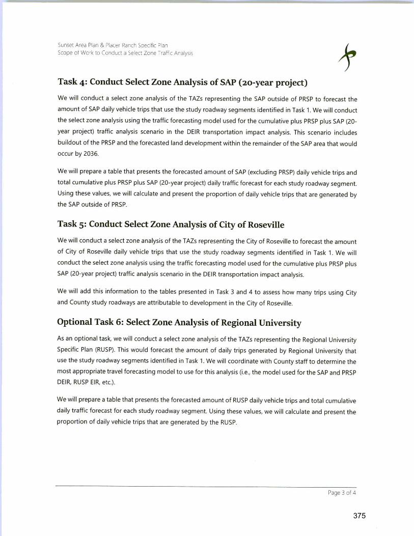
Task 4: Conduct Select Zone Analysis of SAP (20-year project)
We will conduct a select zone analysis of the T AZs representing the SAP outside of PRSP to forecast the
amount of SAP daily vehicle trips that use the study roadway segments identified in Task 1. We will conduct
the select zone analysis using the traffic forecasting model used for the cumulative plus PRSP plus SAP (20-
year project) traffic analysis scenario in the DEIR transportation impact analysis. This scenario includes
buildout of the PRSP and the forecasted land development within the remainder of the SAP area that would
occur by 2036.
We will prepare a table that presents the forecasted amount of SAP (excluding PRSP) daily vehicle trips and
total cumulative plus PRSP plus SAP (20-year project) daily traffic forecast for each study roadway segment.
Using these values, we will calculate and present the proportion of daily vehicle trips that are generated by
the SAP outside of PRSP.
Task 5: Conduct Select Zone Analysis of City of Roseville
We will conduct a select zone analysis of the TAZs representing the City of Roseville to forecast the amount
of City of Roseville daily vehicle trips that use the study roadway segments identified in Task 1. We will
conduct the select zone analysis using the traffic forecasting model used for the cumulative plus PRSP plus
SAP (20-year project) traffic analysis scenario in the DEIR transportation impact analysis.
We will add this information to the tables presented in Task 3 and 4 to assess how many trips using City
and County study roadways are attributable to development in the City of Roseville.
Optional Task 6: Select Zone Analysis of Regional University
As an optional task, we will conduct a select zone analysis of the TAZs representing the Regional University
Specific Plan (RUSP). This would forecast the amount of daily trips generated by Regional University that
use the study roadway segments identified in Task 1. We will coordinate with County staff to determine the
most appropriate travel forecasting model to use for this analysis (i.e., the model used for the SAP and PRSP
DEIR, RUSP EIR, etc.).
We will prepare a table that presents the forecasted amount of RUSP daily vehicle trips and total cumulative
daily traffic forecast for each study roadway segment. Using these values, we will calculate and present the
proportion of daily vehicle trips that are generated by the RUSP.
Page 3 of 4
375
Sunset Area Plan & Placer Ranch Specific Plan Scope of Work to Conduct a Select Zone Traffic Analysis
Task 7: Deliverable
We will prepare a draft technical memorandum that presents the findings from the analysis identified in
Tasks 1 through 6. This will include the tables described in Tasks 2 through 6 and appendices that include
model plots of the select zone model runs.
We have budgeted up to 6 hours to respond to one set of consolidated comments from Placer County staff
on the draft technical memorandum. We will then submit a final memorandum that includes changes to
address these comments, if necessary.
Task 8 : Meetings
This scope of work includes budget for up to four (4 ) in-person meetings during the course of completing
Tasks 1 though 5. This may include meeting with Placer County to finalize methodology and scope, meetings
with Placer County and City of Roseville to review initial results, or at other critical points when County
and/or City staff would like to discuss the study progress, methodology, and/or results. If additional
meetings are required, Fehr & Peers will coordinate with County staff to determine how to accommodate
these additional meetings, and whether additional budget may be necessary.
Cost and Schedule
Fehr & Peers proposes to perform the base tasks shown in the scope of work above (i.e., all tasks except
optional Task 6) on a time-and-materials basis for a not-to-exceed cost of $31 ,800. Assuming we are
authorized to proceed by the end of May 2019, we can complete this work and deliver a draft technical
memorandum by end of July 2019.
Attached is a table that provides the calculations for the not-to-exceed cost estimate. The hourly billing
rates shown in the table are used for calculating the fee estimate only. The attached 2018-2019 hourly
billing rate schedule reflect the actual billing rates that will be used for labor associated with this proposal.
Page 4 of 4
376

Fee Estimate Calculation
Staff Person Labor (hours & billing rates)
Admin/
Principal Support Total
Task $305/hr. $125/hr. Hours Cost
1: Review Impact Locations & Finalize Study Locations 1 4 12 2 2 2: Assess Changes in Daily Traffic Volumes 0 4 12 4 2 3: Select Zone Analysis: PRSP 6 24 2 2 4: Select Zone Analysis: SAP (20-year project) 2 16 2 2 5: Select Zone Analysis: City of Roseville 6 24 2 2 7: Deliverable 2 14 8 4 2 8: Meetings 2 12 8 0 2
Total Labor 8 48 104 16 14
Direct Costs (communications, travel, reproduction, etc.)
Traffic Counts
Total Cost
Optional Task - Fee Estimate Calculation
Tasl<
. . . . ~
Staff Person Labor (hours & billing rates)
Engineer/ Admin/ Principal Associate Planner GIS Support
$305/hr. $195/hr. $145/hr. $120/hr. $125/hr.
20 2 -Direct Costs (communications, travel, reproduction, etc.)f
Total Cos~
21
22
35
23
35
30
24
190
Total
Hours
$3,315
$3,250
$5,445
$3,505
$5,445
$5,230
$4,360
$30,550
$1,250
$0
$31,800
Cost
:t
$220
$5,000
377

FEHR f PEERS
2018-2019
(July 2018 through June 2019)
Hourly Billing Rates
Classification
Principal
Senior Associate
Associate
Senior Engineer/Planner
Engineer/Planner
Senior Engineering Technician
Senior Project Accountant
Senior Administrative Assistant
Administrative Assistant
Technician
Intern
Hourly Rates
$225.00 - $335.00
$170.00 - $335.00
$1 55.00 - $240.00
$130.00 - $190.00
$115.00 - $160.00
$140.00 - $190.00
$150.00 - $155.00
$110.00 - $155.00
$85.00 - $150.00
$110.00 - $140.00
$90.00 - $105.00
• Other Direct Costs I Reimbursable expenses are invoiced at cost plus 10% for handling.
• Personal auto mileage is reimbursed at the then current IRS approved rate (58 cents per mile as of Jan 2079).
• Voice & Data Communications (Telephone, fax, computer, e-mail, etc.) are invoiced at cost as a percentage of project labor.
Fehr & Peers reserves the right to change these rates at any time with or without advance notice.
378