Meja Dam,Bhilwara Western Region Jaipurcgwb.gov.in/District_Profile/Rajasthan/Bhilwara.pdfThe...
22
Meja Dam,Bhilwara Western Region Jaipur 2013 GOVERNMENT OF INDIA MINISTRY OF WATER RESOURCES CENTRAL GROUND WATER BOARD
Transcript of Meja Dam,Bhilwara Western Region Jaipurcgwb.gov.in/District_Profile/Rajasthan/Bhilwara.pdfThe...
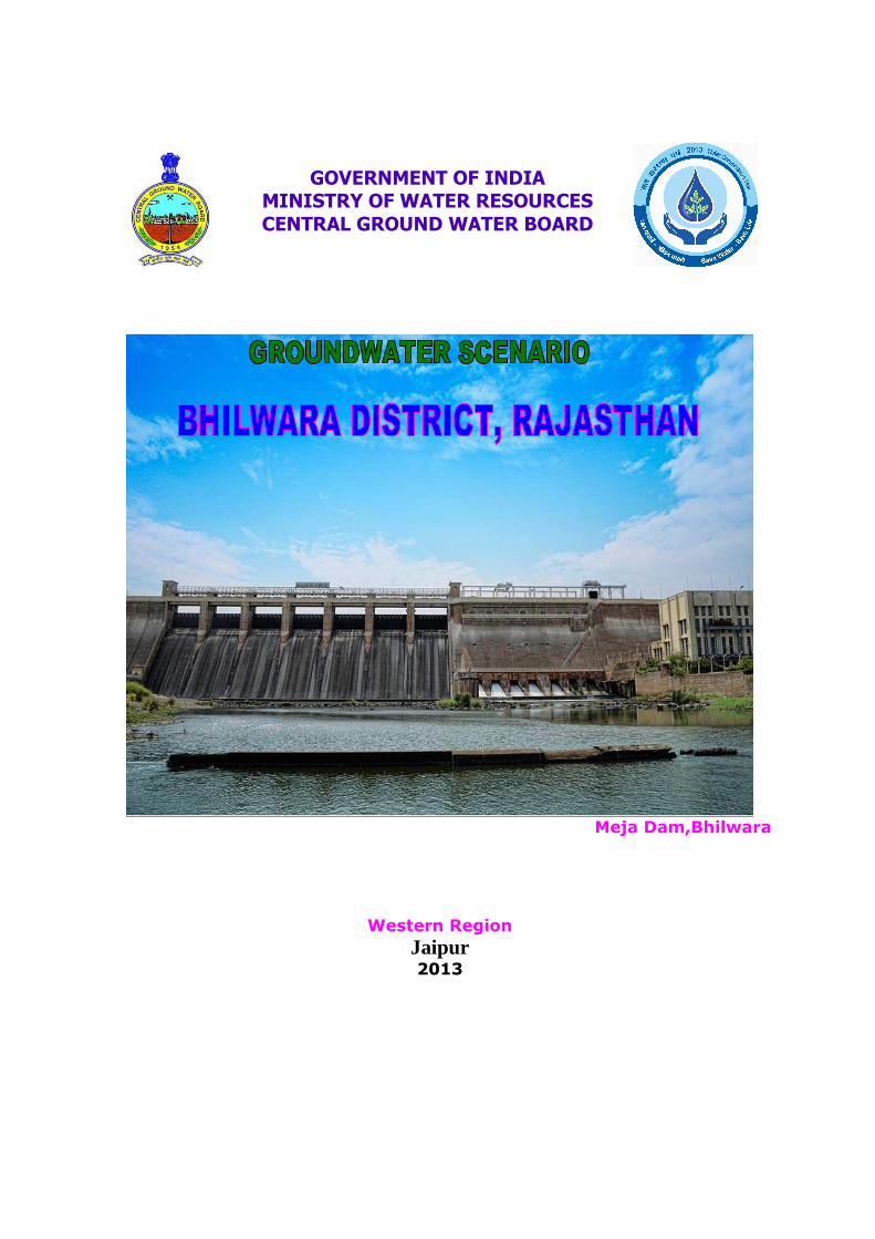
Meja Dam,Bhilwara
Western Region
Jaipur 2013
GOVERNMENT OF INDIA
MINISTRY OF WATER RESOURCES
CENTRAL GROUND WATER BOARD
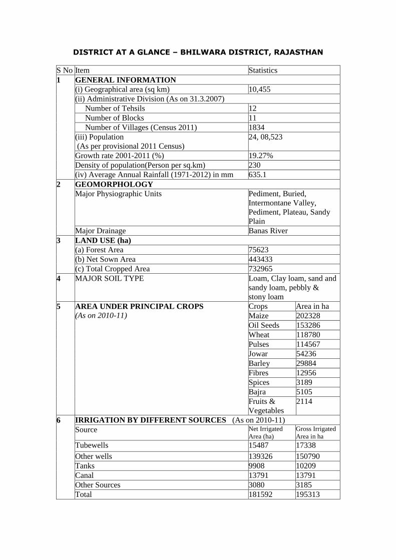
DISTRICT AT A GLANCE – BHILWARA DISTRICT, RAJASTHAN
S No Item Statistics GENERAL INFORMATION (i) Geographical area (sq km) 10,455 (ii) Administrative Division (As on 31.3.2007) Number of Tehsils 12 Number of Blocks 11 Number of Villages (Census 2011) 1834 (iii) Population (As per provisional 2011 Census)
24, 08,523
Growth rate 2001-2011 (%) 19.27% Density of population(Person per sq.km) 230
1
(iv) Average Annual Rainfall (1971-2012) in mm 635.1 GEOMORPHOLOGY Major Physiographic Units Pediment, Buried,
Intermontane Valley, Pediment, Plateau, Sandy Plain
2
Major Drainage Banas River LAND USE (ha) (a) Forest Area 75623 (b) Net Sown Area 443433
3
(c) Total Cropped Area 732965 4 MAJOR SOIL TYPE Loam, Clay loam, sand and
sandy loam, pebbly & stony loam Crops Area in ha Maize 202328 Oil Seeds 153286 Wheat 118780 Pulses 114567 Jowar 54236 Barley 29884 Fibres 12956 Spices 3189 Bajra 5105
5 AREA UNDER PRINCIPAL CROPS (As on 2010-11)
Fruits & Vegetables
2114
IRRIGATION BY DIFFERENT SOURCES (As on 2010-11) Source Net Irrigated
Area (ha) Gross Irrigated Area in ha
Tubewells 15487 17338 Other wells 139326 150790 Tanks 9908 10209 Canal 13791 13791 Other Sources 3080 3185
6
Total 181592 195313
ii
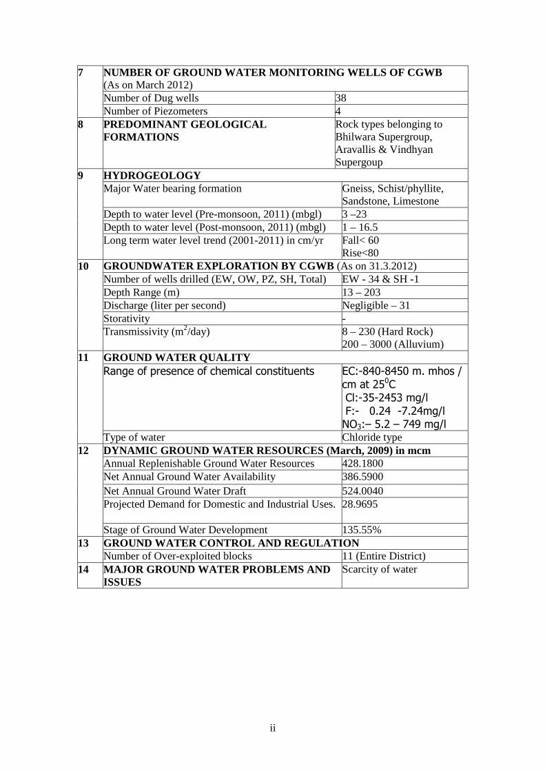
NUMBER OF GROUND WATER MONITORING WELLS OF CGWB (As on March 2012) Number of Dug wells 38
7
Number of Piezometers 4 8 PREDOMINANT GEOLOGICAL
FORMATIONS Rock types belonging to Bhilwara Supergroup, Aravallis & Vindhyan Supergoup
HYDROGEOLOGY Major Water bearing formation Gneiss, Schist/phyllite,
Sandstone, Limestone Depth to water level (Pre-monsoon, 2011) (mbgl) 3 –23 Depth to water level (Post-monsoon, 2011) (mbgl) 1 – 16.5
9
Long term water level trend (2001-2011) in cm/yr Fall< 60 Rise<80
GROUNDWATER EXPLORATION BY CGWB (As on 31.3.2012) Number of wells drilled (EW, OW, PZ, SH, Total) EW - 34 & SH -1 Depth Range (m) 13 – 203 Discharge (liter per second) Negligible – 31 Storativity -
10
Transmissivity (m2/day) 8 – 230 (Hard Rock) 200 – 3000 (Alluvium)
GROUND WATER QUALITY Range of presence of chemical constituents EC:-840-8450 m. mhos /
cm at 250C Cl:-35-2453 mg/l F:- 0.24 -7.24mg/l NO3:– 5.2 – 749 mg/l
11
Type of water Chloride type DYNAMIC GROUND WATER RESOURCES (March, 2009) in mcm Annual Replenishable Ground Water Resources 428.1800 Net Annual Ground Water Availability 386.5900 Net Annual Ground Water Draft 524.0040 Projected Demand for Domestic and Industrial Uses. 28.9695
12
Stage of Ground Water Development 135.55% GROUND WATER CONTROL AND REGULATION 13 Number of Over-exploited blocks 11 (Entire District)
14 MAJOR GROUND WATER PROBLEMS AND ISSUES
Scarcity of water
Ground Water Information Bhilwara District
Contents 1.0 Introduction ....................................................................................1 2.0 Rainfall and Climate ......................................................................3 3.0 Geomorphology, Drainage, Soil, Land Use & Irrigation Practices .....................................................................................................4 3.1 Soils....................................................................................................................5 4.0 Ground Water Scenario.................................................................6 4.1 Hydrogeology....................................................................................................6 4.2 Depth to water level and water level fluctuations .........................................7 4.3 Ground Water Resources..............................................................................11 4.4 Ground Water Quality ..................................................................................12 5.0 Status of Ground Water Development .......................................15 5.1 Ground Water Management Strategy .........................................................16 5.2 Water Conservation and Artificial Recharge..............................................16 6.0 Ground Water Related Issues and Problems ............................17 7.0 Recommendations.........................................................................17
List of Figures 1. Administrative Divisions 2. Hydrogeology 3. Depth to Water Level (May 2011) 4. Depth to Water Level (Nov. 2011) 5. Seasonal fluctuation pre to post Monsoon, 2011 6. Decadal premonsoon fluctuation (2002-2011) 7. Distribution of Electrical Conductivity 8. Distribution of Fluoride 9. Distribution of Nitrate 10. Distribution of Iron
List of Tables 1. Studies undertaken by CGWB 2. Salient features of Ground Water Exploration in Bhilwara district 3. Average annual rainfall for last 10 years 4. Geomorphic units 5. Blockwise area falling in Banas, Cambal and Luni Basins 6. Pre- and Post-monsoon water level (2011) 7. Seasonal Water level fluctuation (2011) 8. Block wise details of Ground Water Recharge, Draft and Category 9. Classification of Ground Water sample based on BIS drinking
water standards 10. Details of Ground Water abstraction structures in the district
GROUND WATER SCENARIO BHILWARA DISTRICT, RAJASTHAN
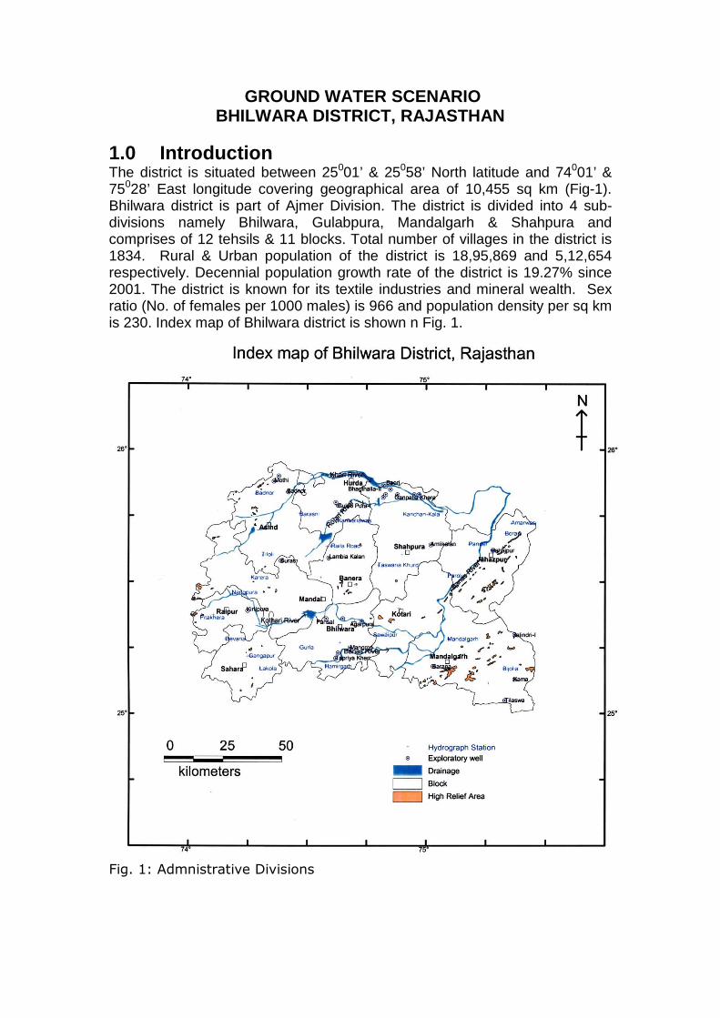
1.0 Introduction The district is situated between 25001’ & 25058’ North latitude and 74001’ & 75028’ East longitude covering geographical area of 10,455 sq km (Fig-1). Bhilwara district is part of Ajmer Division. The district is divided into 4 sub-divisions namely Bhilwara, Gulabpura, Mandalgarh & Shahpura and comprises of 12 tehsils & 11 blocks. Total number of villages in the district is 1834. Rural & Urban population of the district is 18,95,869 and 5,12,654 respectively. Decennial population growth rate of the district is 19.27% since 2001. The district is known for its textile industries and mineral wealth. Sex ratio (No. of females per 1000 males) is 966 and population density per sq km is 230. Index map of Bhilwara district is shown n Fig. 1.
Fig. 1: Admnistrative Divisions
2
Details of various scientific studies carried out by Central Ground Water Board in Bhilwara district are given in Table 1.
Table -1: Studies undertaken by CGWB. S. No. Office/Officer AAP Type of Survey/Study
1 GSI 1962-64 Systematic Hydrogeological Survey
2 Dr. A.N. Lal 1978- 79 Systematic Hydrogeological Survey
3 Tariq Shafiq 1981-82 Systematic Hydrogeological Survey
4 CGWB 1981-84 Hydrogeological investigation along with Exploratory drilling for water supply to Rampura - Agucha mines of Hindustan Zinc Limited.
5 CGWB 1989 Hydrogeological investigation of Banas River.
6 Dr.S.C.Dhiman 1990 Hydrogeological Frame work and ground Water Development Potentialities of Bhilwara District.
7 CGWB 2000-01 Reappraisal hydroeological survey of entire District.
8 Dr. Rakesh Kushwaha
2010-11 Ground Water Development and Management Studies in parts of Bhilwara District
Under Ground Water Exploration Programme, 34 exploratory boreholes and 1 slim hole have been drilled. Salient features of ground water exploration in the district are given in Table 2. Since 1973, monitoring of water levels is being carried out four times a year from 42 National Hydrograph Network Stations.
Table- 2: Salient Features of Ground Water Exploration in Bhilwara district S.
No. Year of cons.
Zones tapped (mbgl)
Formation
Tapped
SWL (m)
Disc. (lpm)
DD (m)
Trans. m2/day
Location
Type of
well
Depth drilled
(m)
Depth constr
(m) From To
1 Bhagthalla-I EW 81-84 26.20 26.20 10 19
1626
Allu - - - -
2 Bhagthalla-II EW 81-84 13.00 12.75 19 26Allu 5.65 250 2.44 845
3 Baori EW 81-84 14.50 14.00 7 11Allu 5.32 400 3.80 499
4 Sanoaria EW 81-84 25.14 20.00 9 18Allu 3.23 1001 1.36 2533
5 Shibji Ka Baag EW 81-84 14.69 14.75 6 14Allu 7.90 1372 1.43 2581
6 Ganpatia Khera EW 81-84 13.00 13.00 7 12Allu 3.89 554 0.70 3108
7 Phulia EW 81-84 16.50 16.00 6 14Allu 2.28 1872 2.24 1585
8 Rampura EW 81-84 21.00 20.50 11 18Allu 8.10 1142 1.21 2507
9 Jalindri-I EW 98-99 14.00 14.00 Naked Qzite 6.20 465 - -
10 Jalindri-II EW 98-99 58.00 58.00 Naked Shale & Qzite
5.51 1223 6.79 230
11 Kama EW 98-99 178.0 178.0 Naked Sst & Shale
8.64 Negl. - -
12 Tilaswa EW 98-99 124.0 124.0 Naked Sst 4.16 1222 6.33 229
13 Sarana EW 98-99 153.2 153.2 Naked Qzite & Phyllite
4.14 660 23.87 50
14 V.S.P.N. Bhilwara
EW 98-99 132.0 132.0 Naked Schist 10.95 484 26.55 15.61
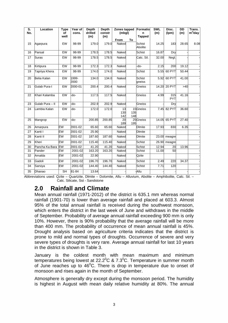
3
S. No.
Year of cons.
Zones tapped (mbgl)
Formation
Tapped
SWL (m)
Disc. (lpm)
DD (m)
Trans. m2/day
Location
Type of
well
Depth drilled
(m)
Depth constr
(m) From To
15 Agarpura EW 98-99 179.0 179.0 Naked Schist Abolite
14.25 183 28.65 8.08
16 Pansal EW 98-99 178.5 178.5 Naked Schist 16.87 Dry - -
17 Suras EW 98-99 178.5 178.5 Naked Calc. Sil. 32.00 Negl. - -
18 Kirtipura EW 98-99 172.3 172.3 Naked -do- 2.15 200 19.12 -
19 Tapriya Khera EW 98-99 174.0 174.0 Naked Schist 5.55 60 PYT 50.44 -
20 Belia Kalan EW 1999-2000
134.0 134.0 Naked Schist gneiss
5.92 60 PYT 41.00 -
21 Gulab Pura-I EW 2000-01 200.4 200.4 Naked Gneiss 14.20 20 PYT >40 -
22 Khari Kalamba EW -do- 117.5 117.5 Naked Gneiss 4.99 315 PYT
41.16 -
23 Gulab Pura – II EW -do- 202.9 202.9 Naked Gneiss - Dry - -
24 Lambia Kalan EW -do- 172.0 172.0 13 130 142
15135148
Gneiss 7.45 82 PYT 36.60 -
25 Mangrop EW -do- 200.85 200.85 20 189
25195
Gneiss 14.05 65 PYT 27.40 -
26 Amarpura EW 2001-02 65.60 65.60 Naked Dlmite 17.93 830 6.35 -
27 Kanti I EW 2001-02 25.90 Naked Dlmite -
28 Kanti II EW 2001-02 187.60 187.60 Naked Dlmite 23.00 meagre -
29 Kheri EW 2001-02 115.40 115.40 Naked Schist 26.90 meagre -
30 Pancha Ka Bara EW 2001-02 41.20 41.20 Naked Schist 12.94 20 13.96 - 31 Pander EW 2001-02 163.20 163.20 Naked Schist 11.00 50 -
32 Amalda EW 2001-02 22.90 Naked Qzite -
33 Gadoli EW 2001-02 196.70 196.70 Naked Schist 2.49 220 34.37 -
34 Sarsiya EW 2001-02 144.40 144.40 Naked Schist 7.71 120 -
35 Dhanao SH 81-84 13.64 - -Allu - - - -
Abbreviations used: Qzite – Quartzite, Dlmite – Dolomite, Allu – Alluvium, Abolite – Amphibolite, Calc. Sil. – Calc. Silicate, Sst - Sandstone
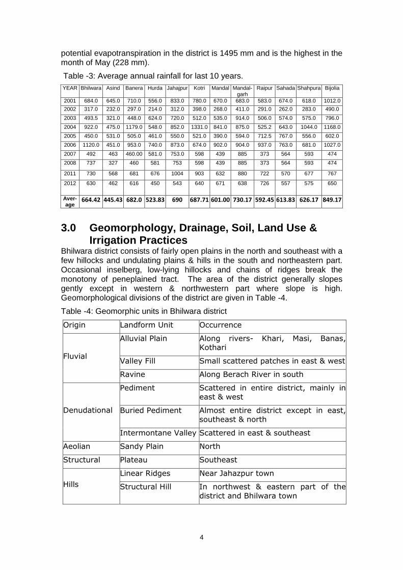
2.0 Rainfall and Climate Mean annual rainfall (1971-2012) of the district is 635.1 mm whereas normal rainfall (1901-70) is lower than average rainfall and placed at 603.3. Almost 95% of the total annual rainfall is received during the southwest monsoon, which enters the district in the last week of June and withdraws in the middle of September. Probability of average annual rainfall exceeding 900 mm is only 10%. However, there is 90% probability that the average rainfall will be more than 400 mm. The probability of occurrence of mean annual rainfall is 45%. Drought analysis based on agriculture criteria indicates that the district is prone to mild and normal types of droughts. Occurrence of severe and very severe types of droughts is very rare. Average annual rainfall for last 10 years in the district is shown in Table 3.
January is the coldest month with mean maximum and minimum temperatures being lowest at 22.20C & 7.30C. Temperature in summer month of June reaches up to 460C. There is drop in temperature due to onset of monsoon and rises again in the month of September.
Atmosphere is generally dry except during the monsoon period. The humidity is highest in August with mean daily relative humidity at 80%. The annual
4
potential evapotranspiration in the district is 1495 mm and is the highest in the month of May (228 mm).
Table -3: Average annual rainfall for last 10 years. YEAR Bhilwara Asind Banera Hurda Jahajpur Kotri Mandal Mandal-
garh Raipur Sahada Shahpura Bijolia
2001 684.0 645.0 710.0 556.0 833.0 780.0 670.0 683.0 583.0 674.0 618.0 1012.0
2002 317.0 232.0 297.0 214.0 312.0 398.0 268.0 411.0 291.0 262.0 283.0 490.0
2003 493.5 321.0 448.0 624.0 720.0 512.0 535.0 914.0 506.0 574.0 575.0 796.0
2004 922.0 475.0 1179.0 548.0 852.0 1331.0 841.0 875.0 525.2 643.0 1044.0 1168.0
2005 450.0 531.0 505.0 461.0 550.0 521.0 390.0 594.0 712.5 767.0 556.0 602.0
2006 1120.0 451.0 953.0 740.0 873.0 674.0 902.0 904.0 937.0 763.0 681.0 1027.0
2007 492 463 460.00 581.0 753.0 598 439 885 373 564 593 474
2008 737 327 460 581 753 598 439 885 373 564 593 474
2011 730 568 681 676 1004 903 632 880 722 570 677 767
2012 630 462 616 450 543 640 671 638 726 557 575 650
Aver-age
664.42 445.43 682.0 523.83 690 687.71 601.00 730.17 592.45 613.83 626.17 849.17
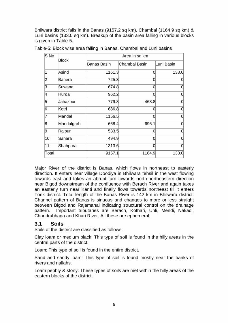
3.0 Geomorphology, Drainage, Soil, Land Use & Irrigation Practices
Bhilwara district consists of fairly open plains in the north and southeast with a few hillocks and undulating plains & hills in the south and northeastern part. Occasional inselberg, low-lying hillocks and chains of ridges break the monotony of peneplained tract. The area of the district generally slopes gently except in western & northwestern part where slope is high. Geomorphological divisions of the district are given in Table -4.
Table -4: Geomorphic units in Bhilwara district
Origin Landform Unit Occurrence
Alluvial Plain Along rivers- Khari, Masi, Banas, Kothari
Valley Fill Small scattered patches in east & west Fluvial
Ravine Along Berach River in south
Pediment Scattered in entire district, mainly in east & west
Buried Pediment Almost entire district except in east, southeast & north
Denudational
Intermontane Valley Scattered in east & southeast
Aeolian Sandy Plain North
Structural Plateau Southeast
Linear Ridges Near Jahazpur town
Hills Structural Hill In northwest & eastern part of the
district and Bhilwara town
5
Bhilwara district falls in the Banas (9157.2 sq km), Chambal (1164.9 sq km) & Luni basins (133.0 sq km). Breakup of the basin area falling in various blocks is given in Table-5.
Table-5: Block wise area falling in Banas, Chambal and Luni basins
Area in sq km S No Block
Banas Basin Chambal Basin Luni Basin
1 Asind 1161.3 0 133.0
2 Banera 725.3 0 0
3 Suwana 674.8 0 0
4 Hurda 962.2 0 0
5 Jahazpur 779.8 468.8 0
6 Kotri 686.8 0 0
7 Mandal 1156.5 0 0
8 Mandalgarh 668.4 696.1 0
9 Raipur 533.5 0 0
10 Sahara 494.9 0 0
11 Shahpura 1313.6 0 0
Total 9157.1 1164.9 133.0
Major River of the district is Banas, which flows in northeast to easterly direction. It enters near village Doodiya in Bhilwara tehsil in the west flowing towards east and takes an abrupt turn towards north-northeastern direction near Bigod downstream of the confluence with Berach River and again takes an easterly turn near Kanti and finally flows towards northeast till it enters Tonk district. Total length of the Banas River is 142 km in Bhilwara district. Channel pattern of Banas is sinuous and changes to more or less straight between Bigod and Rajamahal indicating structural control on the drainage pattern. Important tributaries are Berach, Kothari, Unli, Mendi, Nakadi, Chandrabhaga and Khari River. All these are ephemeral.
3.1 Soils Soils of the district are classified as follows:
Clay loam or medium black: This type of soil is found in the hilly areas in the central parts of the district.
Loam: This type of soil is found in the entire district.
Sand and sandy loam: This type of soil is found mostly near the banks of rivers and nallahs.
Loam pebbly & stony: These types of soils are met within the hilly areas of the eastern blocks of the district.
6
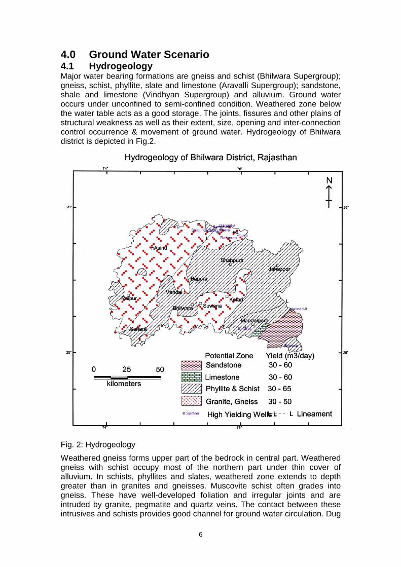
4.0 Ground Water Scenario 4.1 Hydrogeology Major water bearing formations are gneiss and schist (Bhilwara Supergroup); gneiss, schist, phyllite, slate and limestone (Aravalli Supergroup); sandstone, shale and limestone (Vindhyan Supergroup) and alluvium. Ground water occurs under unconfined to semi-confined condition. Weathered zone below the water table acts as a good storage. The joints, fissures and other plains of structural weakness as well as their extent, size, opening and inter-connection control occurrence & movement of ground water. Hydrogeology of Bhilwara district is depicted in Fig.2.
Fig. 2: Hydrogeology
Weathered gneiss forms upper part of the bedrock in central part. Weathered gneiss with schist occupy most of the northern part under thin cover of alluvium. In schists, phyllites and slates, weathered zone extends to depth greater than in granites and gneisses. Muscovite schist often grades into gneiss. These have well-developed foliation and irregular joints and are intruded by granite, pegmatite and quartz veins. The contact between these intrusives and schists provides good channel for ground water circulation. Dug
7
wells in Gangapur and Bhilwara area tapping gneiss and mica schist yield between 25 & 50 m3/day. Joints are well developed in amphibolites and in some porphyritic granites. Dug wells tapping amphibolite yield more (average yield 30 m3/day) as compared to wells in granitic gneiss.
Phyllites and schists are predominating in the eastern parts of the district near Shakargarh, Amalda and Kachola towards north of Great Boundary Fault. These formations are intercalated with dolomitic limestone, quartzite and basic intrusive. Depth of wells tapping these formations varies from 15 to 50 m. Yield of wells varies from 30 to 45 m3/day.
Dolomitic limestone is grey to light brown and compact at the surface. It forms aquifer in intercalations with slates and phyllites around Bagota, Laxmipura, Rampura, Amargarh, Dolpura, Kishangarh, Bakli, Bhajgarh, west of Banakhera, Mal Ka Khera, northeast of Mohanpura, Ladpura and Ratiya Khera. Depth of wells ranges from 15 to 35 m with yield from 50 to 60 m3/day.
Quartzites are generally intercalated with phyllites and slates. These are brown coloured, hard and jointed. Thickness of weathered and fractured zone ranges from 10 to 30 m. Depth of dug wells is generally more than 20m. Yield of dug wells varies from 15 to 25 m3/day. Specific yield of schist/phyllite, gneiss, sandstone and limestone is 1.75%, 1.5%, 1.0% and 2.5% respectively. The transmissivity of aquifer tapping alluvium confined to Banas River varies from 499 to 3108 m2/day whereas in hard rock areas in the district, it varies from 8.08 & 230 m2/day
Sandstone and shale are confined to Mandalgarh block. Dug wells are 3 to 30 m deep and yield water between 40 & 50 m3/day.
Quaternary alluvium is confined to narrow valleys along the river and stream courses. The alluvium is generally shallow but whenever saturated forms good aquifer. Yield of the wells in alluvium ranges from 75 to 100 m3/day.
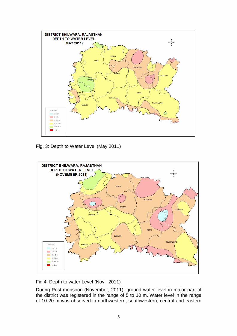
4.2 Depth to water level and water level fluctuations Depth to water level as recorded in 42 NHS during 2011 ranges from 3.00 to 23.00 and 1.00 to 16.00mbgl during pre-monsoon and post monsoon respectively. Block wise depth to water level in the district during pre-monsoon as well as post-monsoon is given in Table 6.
During Pre-monsoon period, depth to water level in major part of the district varies from 10 to 20 mbgl. Depth to water level in the range of 20 to 40 mbgl has been observed in a few wells in Raipur, Mandal, Asind and Harda blocks
8
Fig. 3: Depth to Water Level (May 2011)
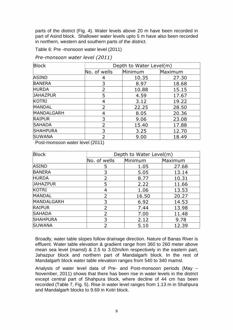
Fig.4: Depth to water Level (Nov. 2011)
During Post-monsoon (November, 2011), ground water level in major part of the district was registered in the range of 5 to 10 m. Water level in the range of 10-20 m was observed in northwestern, southwestern, central and eastern
9
parts of the district (Fig. 4). Water levels above 20 m have been recorded in part of Asind block. Shallower water levels upto 5 m have also been recorded in northern, western and southern parts of the district.
Table 6: Pre -monsoon water level (2011)
Pre-monsoon water level (2011)
Depth to Water Level(m) Block
No. of wells Minimum Maximum ASIND 4 10.35 27.30 BANERA 3 8.97 18.68 HURDA 2 10.88 15.15 JAHAZPUR 5 4.59 17.67 KOTRI 4 3.12 19.22 MANDAL 2 22.25 28.50 MANDALGARH 4 8.05 20.36 RAIPUR 3 9.06 23.08 SAHADA 2 15.40 17.88 SHAHPURA 3 3.25 12.70 SUWANA 2 9.00 18.49 Post-monsoon water level (2011)
Broadly, water table slopes follow drainage direction. Nature of Banas River is effluent. Water table elevation & gradient range from 360 to 260 meter above mean sea level (mamsl) & 2.5 to 3.02m/km respectively in the eastern part, Jahazpur block and northern part of Mandalgarh block. In the rest of Mandalgarh block water table elevation ranges from 540 to 340 mamsl.
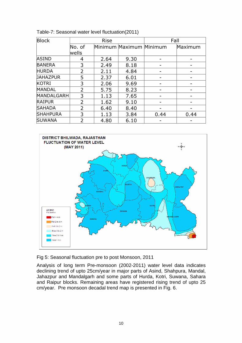
Analysis of water level data of Pre- and Post-monsoon periods (May – November, 2011) shows that there has been rise in water levels in the district except central part of Shahpura block, where decline of 44 cm has been recorded (Table 7, Fig. 5). Rise in water level ranges from 1.13 m in Shahpura and Mandalgarh blocks to 9.69 in Kotri block.
Depth to Water Level(m) Block
No. of wells Minimum Maximum ASIND 5 1.05 27.68 BANERA 3 5.05 13.14 HURDA 2 8.77 10.31 JAHAZPUR 5 2.22 11.66 KOTRI 4 1.06 13.53 MANDAL 2 16.50 20.27 MANDALGARH 3 6.92 14.53 RAIPUR 2 7.44 13.98 SAHADA 2 7.00 11.48 SHAHPURA 3 2.12 9.78 SUWANA 2 5.10 12.39
10
Table-7: Seasonal water level fluctuation(2011)
Rise Fall Block
No. of
wells
Minimum Maximum Minimum Maximum
ASIND 4 2.64 9.30 - - BANERA 3 2.49 8.18 - - HURDA 2 2.11 4.84 - - JAHAZPUR 5 2.37 6.01 - - KOTRI 3 2.06 9.69 - - MANDAL 2 5.75 8.23 - - MANDALGARH 3 1.13 7.65 - - RAIPUR 2 1.62 9.10 - - SAHADA 2 6.40 8.40 - - SHAHPURA 3 1.13 3.84 0.44 0.44 SUWANA 2 4.80 6.10 - -
Fig 5: Seasonal fluctuation pre to post Monsoon, 2011
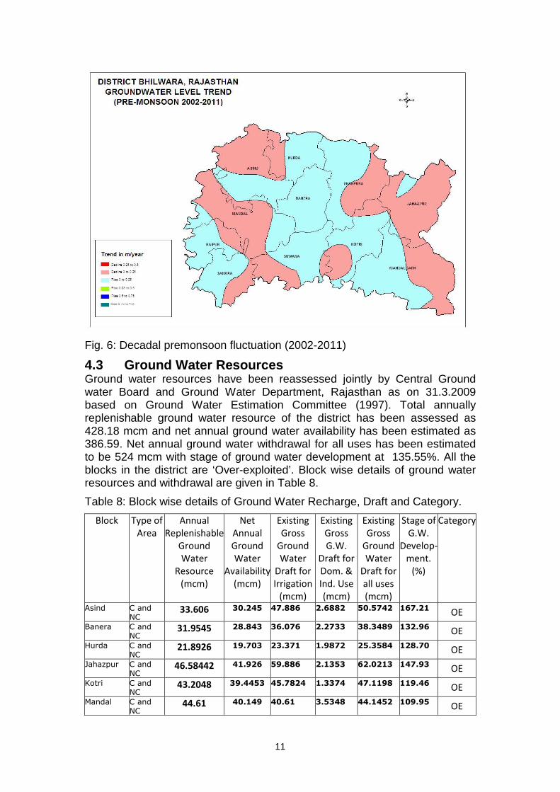
Analysis of long term Pre-monsoon (2002-2011) water level data indicates declining trend of upto 25cm/year in major parts of Asind, Shahpura, Mandal, Jahazpur and Mandalgarh and some parts of Hurda, Kotri, Suwana, Sahara and Raipur blocks. Remaining areas have registered rising trend of upto 25 cm/year. Pre monsoon decadal trend map is presented in Fig. 6.
11
Fig. 6: Decadal premonsoon fluctuation (2002-2011)
4.3 Ground Water Resources Ground water resources have been reassessed jointly by Central Ground water Board and Ground Water Department, Rajasthan as on 31.3.2009 based on Ground Water Estimation Committee (1997). Total annually replenishable ground water resource of the district has been assessed as 428.18 mcm and net annual ground water availability has been estimated as 386.59. Net annual ground water withdrawal for all uses has been estimated to be 524 mcm with stage of ground water development at 135.55%. All the blocks in the district are ‘Over-exploited’. Block wise details of ground water resources and withdrawal are given in Table 8.
Table 8: Block wise details of Ground Water Recharge, Draft and Category.
Block Type of
Area
Annual
Replenishable
Ground
Water
Resource
(mcm)
Net
Annual
Ground
Water
Availability
(mcm)
Existing
Gross
Ground
Water
Draft for
Irrigation
(mcm)
Existing
Gross
G.W.
Draft for
Dom. &
Ind. Use
(mcm)
Existing
Gross
Ground
Water
Draft for
all uses
(mcm)
Stage of
G.W.
Develop-
ment.
(%)
Category
Asind C and NC
33.606 30.245 47.886 2.6882 50.5742 167.21 OE
Banera C and NC
31.9545 28.843 36.076 2.2733 38.3489 132.96 OE
Hurda C and NC
21.8926 19.703 23.371 1.9872 25.3584 128.70 OE
Jahazpur C and NC
46.58442 41.926 59.886 2.1353 62.0213 147.93 OE
Kotri C and NC
43.2048 39.4453 45.7824 1.3374 47.1198 119.46 OE
Mandal C and NC
44.61 40.149 40.61 3.5348 44.1452 109.95 OE
12
Block Type of
Area
Annual
Replenishable
Ground
Water
Resource
(mcm)
Net
Annual
Ground
Water
Availability
(mcm)
Existing
Gross
Ground
Water
Draft for
Irrigation
(mcm)
Existing
Gross
G.W.
Draft for
Dom. &
Ind. Use
(mcm)
Existing
Gross
Ground
Water
Draft for
all uses
(mcm)
Stage of
G.W.
Develop-
ment.
(%)
Category
MandalgarhC and NC
69.0157 62.1141 86.484 4.0357 90.5197 145.73 OE
Raipur C and NC
21.505 19.354 30.745 1.7666 32.5118 167.98 OE
Sahada C and NC
21.6204 19.529 146.98 1.9079 26.8367 137.42 OE
Shahpura C and NC
48.9306 44.5497 44.4405 2.2608 46.7013 104.83 OE
Suwana C and NC
45.256 40.7304 55.8765 3.99021 59.86671 24.929 OE
TOTAL OF
DISTRICT
428.1800 386.59 496.09 27.9174 524.00 135.55 OE
4.4 Ground Water Quality In the district, 33 water samples were collected during May 2011.
The classification of ground water samples was carried out based on the desirable and maximum permissible limits for the parameters
viz., TDS, TH, Ca, Mg, Cl, SO4 and NO3 prescribed in the standards and is given in table 9.
Table 9--Classification of Ground Water Samples based on BIS Drinking Water Standards (IS-10500-91, Revised 2003)
Parameters DL MPL Samples with conc.
< DL
Samples with conc. in DL-MPL
Samples with conc. >MPL
TDS 500 2000 0 22 11
Chloride 250 1000 13 15 5
Sulphate 200 400
(if Mg does not exceed
30ppm)
18 10 5
Nitrate 45 - 18 15
Fluoride 1 1.5 12 7 14
Calcium 75 200 19 13 1
Magnesium 30 100 13 15 5
Iron 0.3 1.0 18 13 2
TH 300 >600 12 12 9
(Here, DL- Desirable Limit, MPL- Maximum Permissible Limit)
13
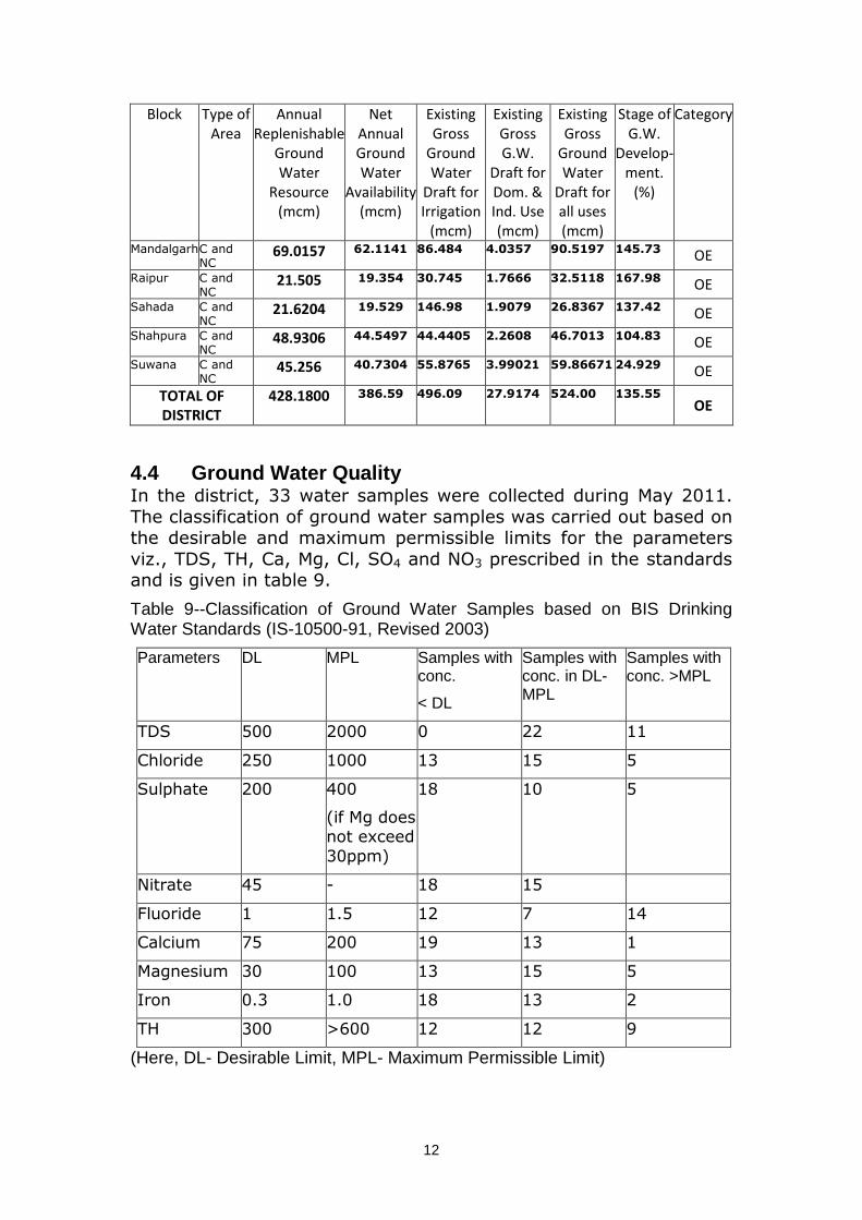
In greater part of the district covering mainly the southern & eastern part, ground water quality in shallow aquifer is fresh with electrical conductance less than 2000 mmhos/cm at 250C (Fig. 7). Ground water of high electrical conductance occurs in small isolated patches. In the northern parts, i.e. parts of Hurda, Shahpura, Asind and Jahajpur blocks and part of Mandal block, groundwater is comparatively more saline with electrical conductivity 2000 to 3000 mmhos/cm at 250C or higher. Variation in conductivity is confirmed by presence of chloride. Electrical conductivity at small patches of Suwana, Jahajpur, Asind and Shahpura blocks has been recorded more than 10000 µS/cm at 250 C. Borewells drilled at Vijay Singh Pathik Nagar (Bhilwara City), Gulabpura and Mangrop show EC values 5640, 5430 & 36280 µS/cm at 250 C respectively. Groundwater is brackish (more than 3000 to 18030) at Bhilwara – Ajmer border along the Khari River. High conductivity in groundwater makes the area unfit for non-salt tolerance crops. Salt tolerant crops are suggested in these areas.
Fig 7: Distribution of Electrical Conductivity
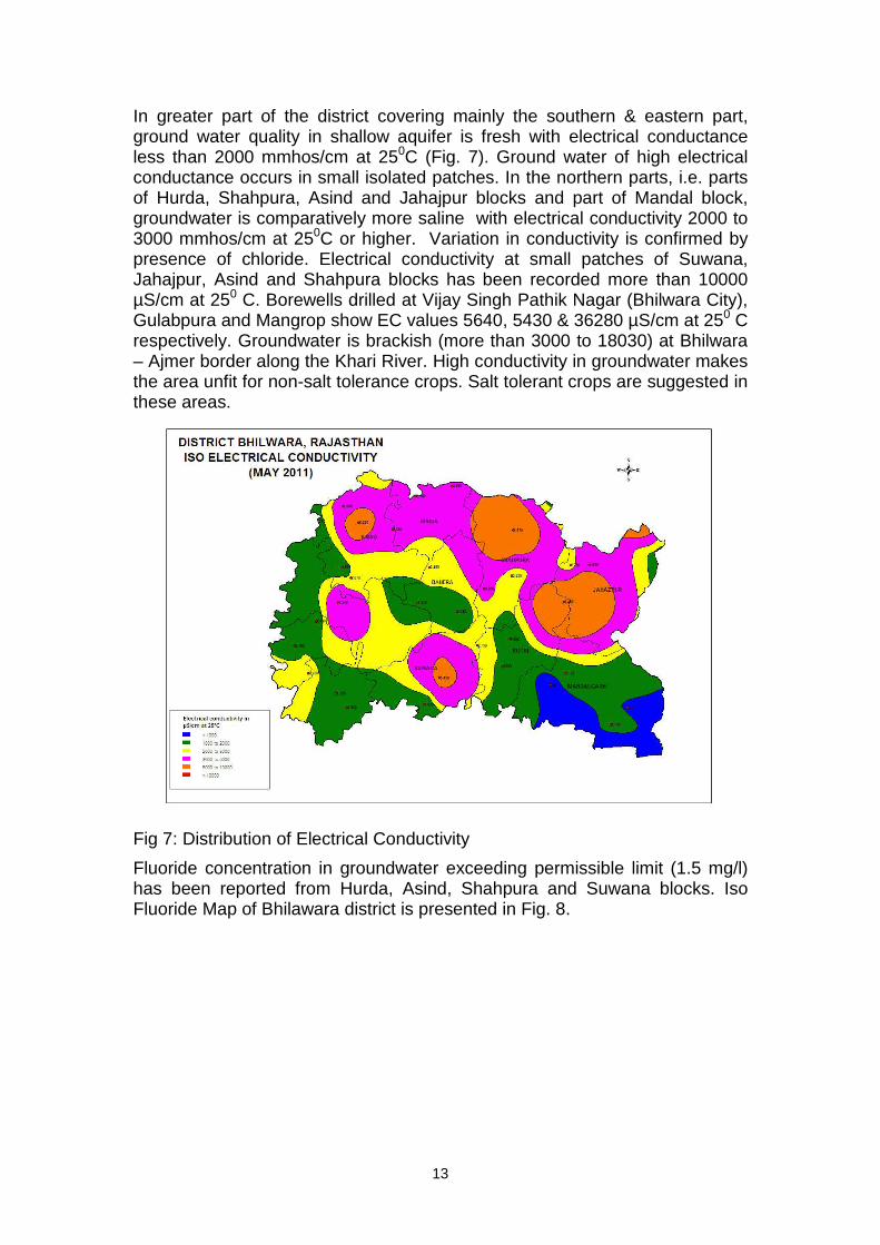
Fluoride concentration in groundwater exceeding permissible limit (1.5 mg/l) has been reported from Hurda, Asind, Shahpura and Suwana blocks. Iso Fluoride Map of Bhilawara district is presented in Fig. 8.
14
Fig. 8: Distribution of Fluoride.
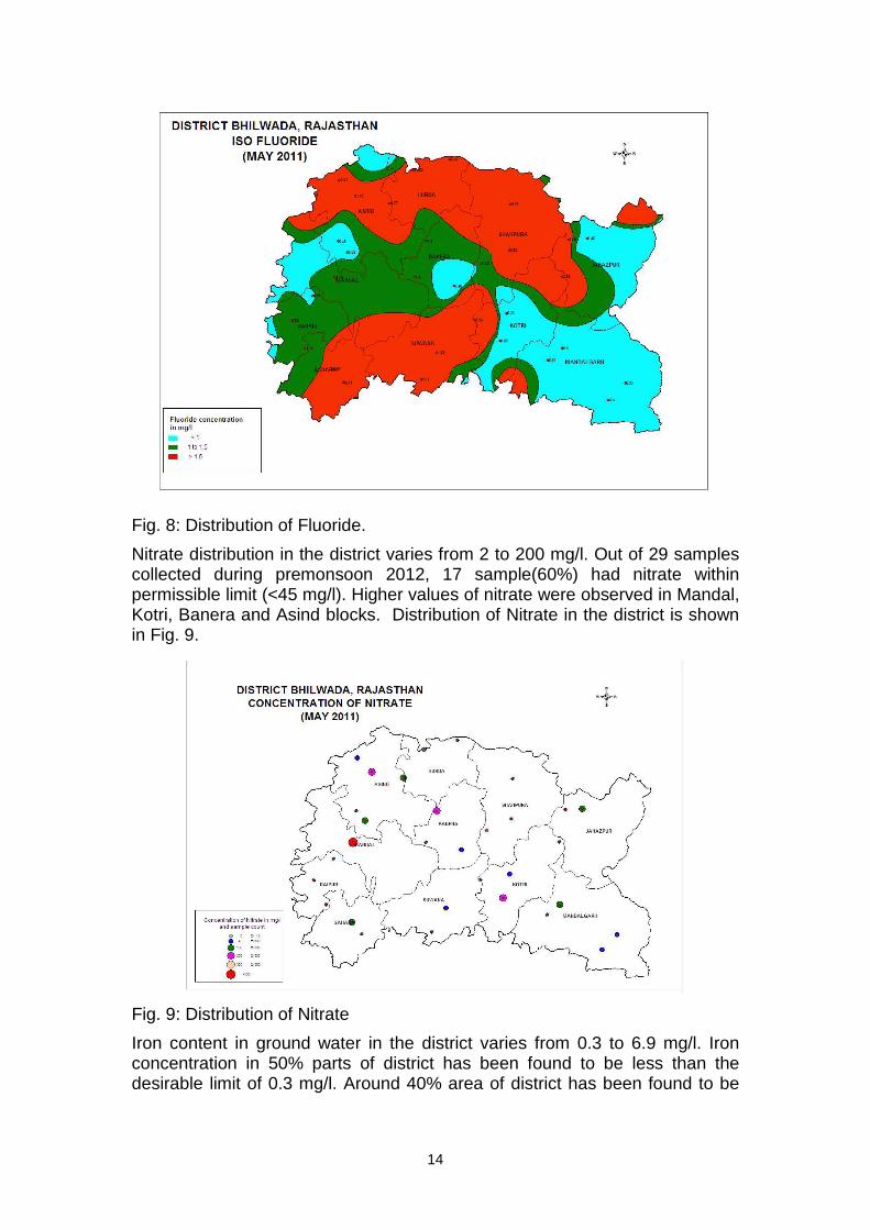
Nitrate distribution in the district varies from 2 to 200 mg/l. Out of 29 samples collected during premonsoon 2012, 17 sample(60%) had nitrate within permissible limit (<45 mg/l). Higher values of nitrate were observed in Mandal, Kotri, Banera and Asind blocks. Distribution of Nitrate in the district is shown in Fig. 9.
Fig. 9: Distribution of Nitrate
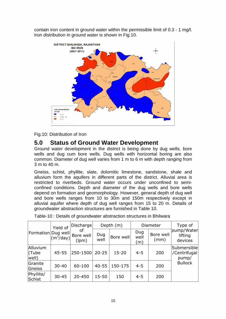
Iron content in ground water in the district varies from 0.3 to 6.9 mg/l. Iron concentration in 50% parts of district has been found to be less than the desirable limit of 0.3 mg/l. Around 40% area of district has been found to be
15
contain iron content in ground water within the permissible limit of 0.3 - 1 mg/l. Iron distribution in ground water is shown in Fig.10.
Fig.10: Distribution of Iron
5.0 Status of Ground Water Development Ground water development in the district is being done by dug wells, bore wells and dug cum bore wells. Dug wells with horizontal boring are also common. Diameter of dug well varies from 1 m to 6 m with depth ranging from 3 m to 40 m.
Gneiss, schist, phyllite, slate, dolomitic limestone, sandstone, shale and alluvium form the aquifers in different parts of the district. Alluvial area is restricted to riverbeds. Ground water occurs under unconfined to semi-confined conditions. Depth and diameter of the dug wells and bore wells depend on formation and geomorphology. However, general depth of dug well and bore wells ranges from 10 to 30m and 150m respectively except in alluvial aquifer where depth of dug well ranges from 15 to 20 m. Details of groundwater abstraction structures are furnished in Table 10.
Table-10 : Details of groundwater abstraction structures in Bhilwara
Depth (m) Diameter
Formation
Yield of Dug well
(m3/day)
Discharge of
Bore well (lpm)
Dug well
Bore well Dug well (m)
Bore well (mm)
Type of pump/Water
lifting devices
Alluvium (Tube
well)
45-55 250-1500 20-25 15-20 4-5 200
Granite
Gneiss 30-40 60-100 40-55 150-175 4-5 200
Phyllite/ Schist
30-45 20-450 15-50 150 4-5 200
Submersible /Centrifugal
pump/ Bullock
16
Dolomitic Limestone
50-60 20-500 15-25 150 4-5 200
Quartzite 15-25 20-600 10-30 150 4-5 200
Sandstone Shale
40-50 20-500 3-30 150 4-5 200
5.1 Ground Water Management Strategy Ground Water Development
Stage of ground water development in the district is 135.55%, which indicates that the scope of ground water development is already exhausted. All the blocks are “Over-exploited”. Most of the boreholes have been drilled in the northern part of district falling in Shahpura, Hurda, Asind blocks and southern part in Suwana block. There is no scope for further development in the district for irrigation or industrial use. However, exploratory drilling can be taken up in unexplored area for estimation of aquifer parameters.
5.2 Water Conservation and Artificial Recharge In view of over development, further exploitation of precious resource needs to be checked. For sustainable development of ground water, artificial recharge measures need to be adopted to augment ground water and surface water resources. M/s Hindustan Zinc Limited (HZL) has constructed collector well in Banas River, in the downstream side of Ghewaria mines, which is being recharged after dewatering of soapstone mine at Ghewaria, whenever the dewatering stops, discharge of collector well reduces drastically. Exploratory drilling results have shown potential zone having inferior quality water, which can be blended with fresh water for irrigation use.
Artificial recharge is the only solution to augment ground water through construction of bunds, anicuts, and rooftop harvesting structures. The area has undergone polyphase deformation in geological past, which has resulted in a complex structure (folded, faulted and jointed) that may not be conducive for such structures. Therefore, site of these structures should be selected carefully.
Watershed Development & Soil Conservation Department has constructed permanent (masonry) check dams under Irrigated Watershed Development Project to harvest rainwater, reduce soil erosion and check runoff velocity. In the district 285 check dams covering an area of 108962 ha have been constructed.
Impact assessment of check dams has revealed increase in water level, cropping area, cropping intensity, crop production and labor employment in the project area. Erosion from nallah bank has minimized. Cropping pattern and cropping intensity have changed. Harvested water provides supplementary irrigation during long dry spell. In view of the above, such artificial recharge programmes may be taken up in the district to ensure availability of water on sustainable basis to enhance agricultural production.
17
6.0 Ground Water Related Issues and Problems Almost entire district is facing problem of ground water scarcity. Over the greater part of the district occupied by hard rock formation, the well yields are very poor. As such the depth of weathered zone is generally restricted up to 30m, which control the occurrence and movement of groundwater. Deep-seated fractures below 100m are very rare. This causes reduction in the well yield drastically during the summers creating acute water shortage of domestic water supply. However, in selective areas located on structurally weak planes connected to some recharge source, wells continue to yield moderate quantity of water. Deeper levels are either devoid of water or of poor quality of ground water (brackish to saline). Alluvium occurs at limited places along the major drainage/ valley fills but has very shallow thickness. The well yield varies considerably year to year in different parts of the district and over the season. Thus the availability of surface as well as ground water is very scarce in low rainfall years & especially in summer months.
7.0 Recommendations • Ground water draft is very high in almost all the blocks. Exploitation of
ground water has to be controlled by preventing further development.
• Revival of traditional ground water storage system i.e. Baori, open wells, Tanka etc. for rainwater conservation for use in day to day life will reduce ground water draft.
• There are 352 textile related industries located in Bhilwara and Gulabpura town. These industries consume huge quantity of water resulting in drinking water problem. Effluent is left untreated and allowed to mingle with ground water. Regular monitoring is required and check on disposal of untreated wastes can prevent ground water from getting polluted.
• Awareness programmes and training on rainwater harvesting will be beneficial to check the decline in water level and justified use.
• Taking advantage of uneven topography of the area, small check dams or earthen dams, upstream of irrigation commands, at suitable sites, may be constructed to store rainwater. This will increase recharge to ground water which would ultimately result in increase of yield of wells.
• An area of 794.18 sq km is occupied by forest. To protect the area from environmental degradation, extensive programme of afforestation and soil conservation measures needs to be taken up.
• Modern agricultural management techniques have to be adopted for effective and optimum utilization of the water resources. Maintaining irrigation through minimum pumping hours as per minimum requirement of water by the crop and also selecting most suitable cost effective cropping pattern can help in water conservation.
• Alluvial tracts along river channels of Banas, Kothari, Khari, Manusi and Chandrabhaga are most feasible locations where shallow wells can be constructed to harness the shallow water table aquifers being

18
potentially recharged by the flash flood and surface runoff. These wells can be used for water supply, wherever feasible.
• Surface runoff can be harnessed by constructing tanks at feasible sites in the area occupied by the hard rock terrain for supplementing irrigation potential to increase the agricultural production.
• High water requirement crops are discouraged. Proper agriculture extension services should be provided to the farmers so that they can go for alternate low water requirement economical crops.