Megan Atkinson - Chocolate House Historic Building Record
72
Historic Building Record The 1657 Chocolate House, 54 Branthwaite Brow, Kendal, Cumbria LA9 4TX Listing NGR: SD5162892765 Prepared by Megan Atkinson May 2015
-
Upload
megan-atkinson -
Category
Documents
-
view
8 -
download
0
Transcript of Megan Atkinson - Chocolate House Historic Building Record

Historic Building Record
The 1657 Chocolate House,
54 Branthwaite Brow, Kendal, Cumbria
LA9 4TX
Listing NGR: SD5162892765
Prepared by
Megan Atkinson
May 2015

Contents
1. Summary
2. Introduction
3. General Description
4. Building Record
5. Interpretation
6. Bibliography
7. Appendices
Appendix ‘A’ – Drawn Record
Appendix ‘B’ – Heritage Statement of Significance (Atkinson 2015)

1 SUMMARY
The 1657 Chocolate House is located in Kendal’s town centre, in Cumbria. It is a 17th century single
pile, timber framed construction that has been refaced in limestone rubble. The building lies within a
Conservation Area and is grade II listed alongside a grade II listed late 17th century burgage plot to
the north of the building. There lies a walkway to Yard 52 between these two buildings, but a jetty
overhead provides a structural connection between the buildings. The 1657 Chocolate House is a
vernacular building showing later influence of polite neo-classical architectural detailing, currently
being used as a tearoom and chocolate shop. The purpose of its original construction is unrecorded,
but is believed by the author (Atkinson 2015) to have been built for domestic textile making because
of the height arrangement of the second floor and the partially underground arrangement of the
ground floor (Appendix A). In addition, domestic textile making was crucial to Kendal’s prominence
as a centre for wool production in the medieval and post-medieval era (Bingham 1995).
The building has undergone many changes in form and function since the 17th century, which has
negatively impacted its historical legibility. The building was recorded as two separate dwellings in
the 19th century census information and OS maps; the ground floor was identified as no. 56 and the
first and second floors as no. 54 Branthwaite Brow. The workshop and domestic industry tradition
continued in the building until the end of the 19th century when the dwellings were legally reunified;
it was turned into a shop on the first and second floor (no.54) and a residential area on the ground
floor (no. 54a). The building still remained physically separated until the internal staircase between
the ground and first floor was unblocked in the 1960s. It became the ‘1657 Chocolate House’ in the
1980s when it was converted into a tearoom and chocolate shop. Its current address is now just 54
Branthwaite Brow for the entire building. There are no current proposals for change in the building
and this document has been prepared along with a Heritage Statement of Significance.
2 INTRODUCTION
2.1 PURPOSE AND FORMAT
This Historic Building Record has been produced in conjunction with a Heritage Statement of
Significance (Appendix B) as a means of recording the existing features and layout of the building in
2015. There are no current proposals for change at the grade II listed 1657 Chocolate House,
therefore this record can be used for future proposed works. The record follows the recommended
format from Historic England’s Understanding Historic Buildings: A Guide to Good Recording Practice
(2006).
2.2 AUTHOR
The author, Megan Atkinson, is currently studying for an Msc in Building Conservation and
Regeneration at the University of Central Lancashire.
2.3 METHODS OF INVESTIGATION AND RECORDING
Visual inspections were carried out in March and April 2015 without the aid of existing layout plans.
Dimensions of the building were taken by the author to create layout and elevation drawings. Digital
photographs and layout drawings are provided in the record: the photographs are mainly found in
section 4 and the record drawings are contained in appendix ‘A’. The horizontal measurements were
taken at approximately 1 metre height and, to clarify how the building was intended to be
constructed, the building is drawn with straight lines. However, with movement over time the
building has become distorted, which is visible in the photographic record. A plan that indicates the
location of each photograph is also given in section 4. The Heritage Statement of Significance for the
building is contained in appendix ‘B’ and will be referred to in this document.
3 GENERAL DESCRIPTION
3.1 SITE LOCATION
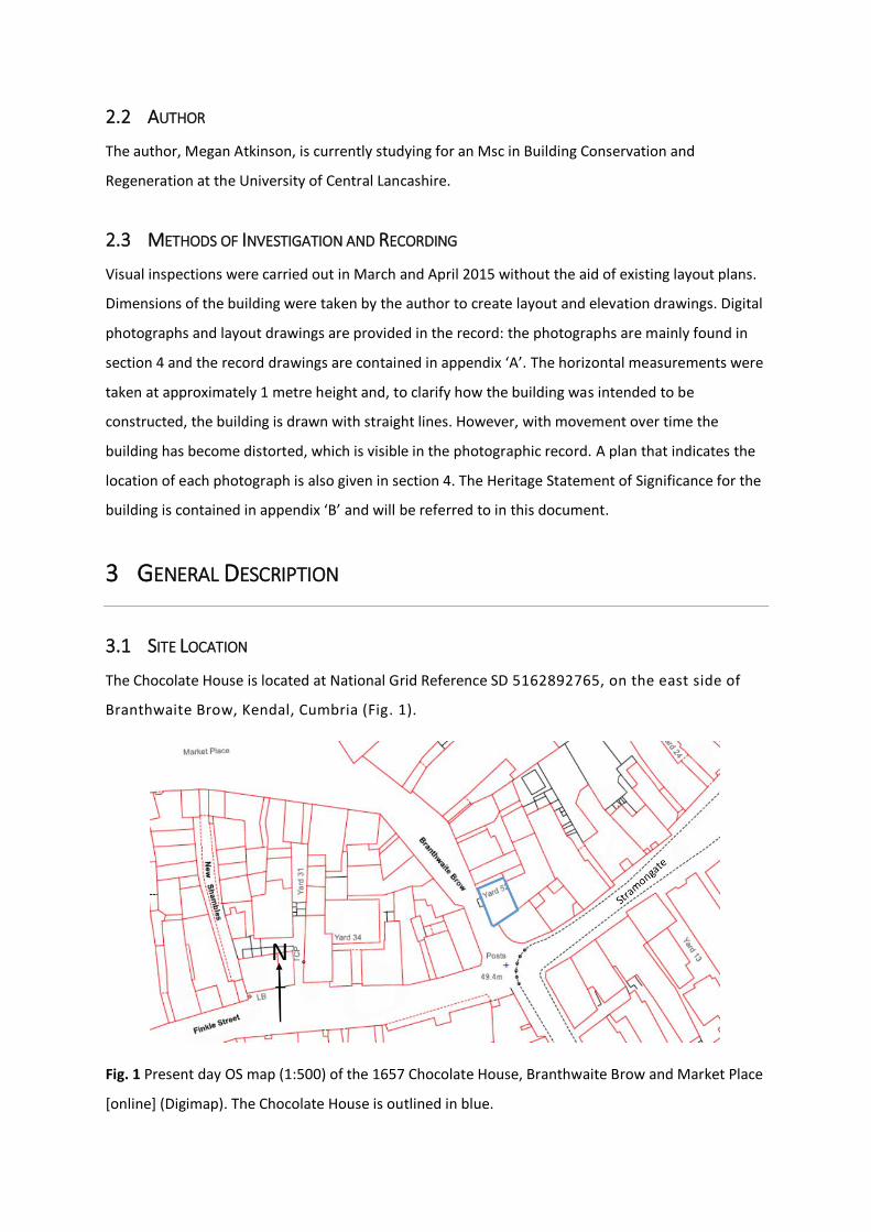
The Chocolate House is located at National Grid Reference SD 5162892765, on the east side of
Branthwaite Brow, Kendal, Cumbria (Fig. 1).
Fig. 1 Present day OS map (1:500) of the 1657 Chocolate House, Branthwaite Brow and Market Place
[online] (Digimap). The Chocolate House is outlined in blue.

3.2 SITE DESCRIPTION
The 1657 Chocolate House is a single pile building with a jetty attached to no. 50 Branthwaite Brow
and situated next to no. 2 Stramongate (Fig. 2). The building faces south west onto the cobble stone
street of Branthwaite Brow and can be accessed by two main doors: one to the left has steps up to
the first floor and the second on the right has a step down to the ground floor (Fig. 3). The north end
of the building is attached to the entrance to yard 52 (Fig. 4). Access to the rear of the building has
been blocked off by a 20th century development in yard 52.
Fig. 2 Site Plan (1:100) of 1657 Chocolate House and the immediate surrounding buildings.

Fig. 3 The front elevation of the 1657 Chocolate House.
Fig. 4 The entrance to yard 52 is situated next to the Chocolate House on the right. A strong visual
characteristic of Kendal is the large amount of long yards that run back from the street frontages
(White 2013). The ‘Kendal yards’ originate from the long burgage plots of the Middle Ages and later
became areas for people to carry out their trade or craft, or even keep animals (White 2013).
Brunskill (2002) discusses how they were crucial to Kendal’s development as the centre of domestic
and workshop textile industry in Westmorland up until the late 18th century when the development
of industrial buildings took over the process of wool and cloth making.
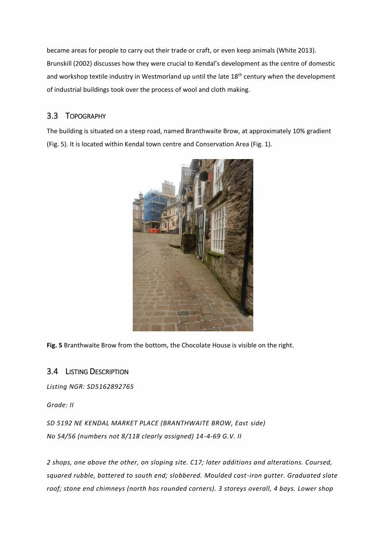
3.3 TOPOGRAPHY
The building is situated on a steep road, named Branthwaite Brow, at approximately 10% gradient
(Fig. 5). It is located within Kendal town centre and Conservation Area (Fig. 1).
Fig. 5 Branthwaite Brow from the bottom, the Chocolate House is visible on the right.
3.4 LISTING DESCRIPTION
Listing NGR: SD5162892765
Grade: II
SD 5192 NE KENDAL MARKET PLACE (BRANTHWAITE BROW, East side)
No 54/56 (numbers not 8/118 clearly assigned) 14-4-69 G.V. II
2 shops, one above the other, on sloping site. C17; later additions and alterations. Coursed,
squared rubble, battered to south end; slobbered. Moulded cast-iron gutter. Graduated slate
roof; stone end chimneys (north has rounded corners). 3 storeys overall, 4 bays. Lower shop

on right: Recessed C20 door (with contemporary iron grille in front); small fixed window to
left and bow window to right, both with glazing bars. 2-light wood-mullioned casement to
left of stone steps to upper shop's (lst floor) entrance: Recessed C20 glazed door with bay
window on brackets immediately to right; sash to left and to far right. 3 wood -mullioned
casements to 2nd floor of 2 , 3 and 4 lights; wrought-iron bracket between middle and right-
hand windows supports C20 sign.
4 BUILDING RECORD
4.1 ORIENTATION
The front elevation of the 1657 Chocolate House faces south west onto Branthwaite Brow (Fig. 1).
4.2 OVERVIEW – BUILDING PLANS AND MATERIALS
The 1657 Chocolate House is a single pile, three bay and three storey structure. The original
construction is a timber box-frame construction that has been built into the steepness of the road.
Therefore, the ground floor has a smaller floor plan than the first and second floors and is partially
underground. The building has been refaced in rough coursed limestone rubble.
The building is connected to no. 50 via a jetty over the walkway to Yard 52, but the door access on
the second floor to this jetty has been barred up. The building has a graduated slate roof and the
roof comprises of king-post trusses, rafters and purlins. There is a stone chimney stack at both gable
ends: the north end stack has rounded corners.
The front elevation has no symmetrical features and the features, such as windows, are different
styles and shapes. There is neo-classical architectural influence on the style of some of the windows,
but they have been interpreted differently. Unlike traditional six-over-six sash windows from the
Georgian period (Glancey 2000), two from the first floor are a wooden framed ten-over-ten sash
style and one on the ground floor is the same style but not a sash window. In addition there is an
oriel window situated on the first floor. The second floor has three windows, two to the north end
and one at the south end window which has a double eight pane style referred to as ‘weavers’
windows’ (Brunskill 1997: 154). Additionally, the ground floor has two smaller windows. There are
two main doors: one to access the first floor and the second to access the ground floor. Both are
recessed, but the current doors are a 20th century wooden door with glass panes.
The rear elevation of the building has been blocked up by a 20th century extension to a neighbouring
building, but a single corner window is visible on the second floor and a wooden paned door with a
window and letter box exists on the jetty between no.54 and 50, but there is no existing staircase to
this.
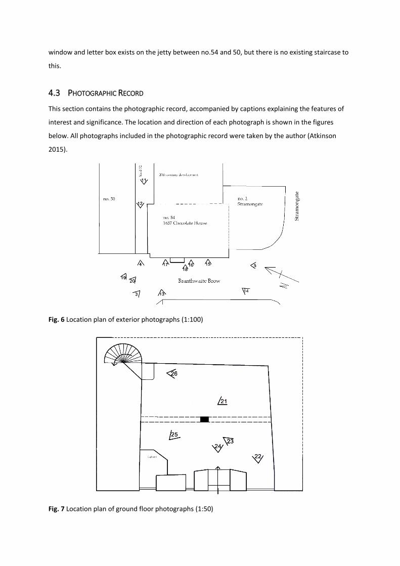
4.3 PHOTOGRAPHIC RECORD
This section contains the photographic record, accompanied by captions explaining the features of
interest and significance. The location and direction of each photograph is shown in the figures
below. All photographs included in the photographic record were taken by the author (Atkinson
2015).
Fig. 6 Location plan of exterior photographs (1:100)
Fig. 7 Location plan of ground floor photographs (1:50)
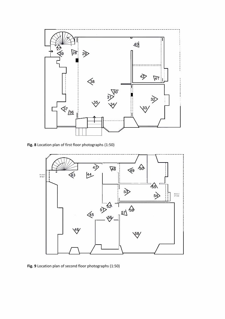
Fig. 8 Location plan of first floor photographs (1:50)
Fig. 9 Location plan of second floor photographs (1:50)

Fig. 10 Location plan of attic and roof truss photographs (1:50)
Fig. 11 Rear elevation of the corner of no. 54 Branthwaite Brow on the left. The walkway and
entrance to Yard 52 is situated underneath a jetty between no. 54 and 50. ‘The design of the
medieval town house was governed largely by a lack of space’ (Cunnington 1980: 53) and this jetty
would have allowed access to a yard at the rear of the building. A door made of wood planks is
visible above this walkway, which implies there was once access to the second floor of the building
through this. Additionally there is a corner window.

Fig. 12 View of the walkway to Yard 52 facing onto Branthwaite Brow – a fire exit door from the first
floor is visible on the left. Timber posts unconnected to the structure are situated at the top of the
walkway.
Fig. 13 Front elevation of the north end of the building. A main entrance to the first floor is accessed
by stone steps on the left.

Fig. 14 Front elevation of the south end of the building. A main entrance to the ground floor is
accessed by a step down to a recessed door.
Fig. 15 Front elevation of the ground floor entrance door. The door itself is a 20th century
replacement but this would have accessed what was no. 56 when the building was recorded as
separate dwellings in the 19th century census, as highlighted in appendix ‘B’.

Fig. 16 A small ground floor window with no similarity to other windows in the building.
Fig. 17 A ground floor window which, again, has no similarities to other windows in the building.

Fig. 18 A projecting window is located on the first floor. It is known as an oriel window because,
unlike a bay window, it does not reach the ground but is ‘supported on a corbel or bracket’
(Yarwood 1993: 417).
Fig. 19 North end chimney stack with rounded corners. ‘[I]n the Lake District the difficulties of
producing squared-off corners using the hard, irregular local stone led to the building of many
circular chimney stacks’ (Breckon et al. 2000: 159).
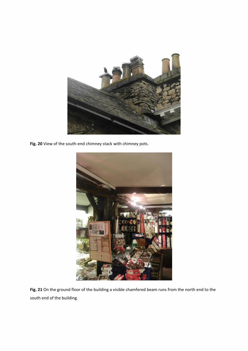
Fig. 20 View of the south-end chimney stack with chimney pots.
Fig. 21 On the ground floor of the building a visible chamfered beam runs from the north end to the
south end of the building.

Fig. 22 The style of this window imitates the sash-style windows on the first floor (see later
photographs) but has no opening. The window is actually situated in front of the timber frame, and
continues slightly higher than the ceiling height of the room. The depth of the wall is also visible on
the right.
Fig. 23 The main timber post of the ground floor is shown again. There are later 20th century
additions of plastic replica looking timber beams that have been placed in a diagonal arrangement
from the main post and have no historical connection to the construction, which has been addressed
in appendix ‘B’.

Fig. 24 This is a 20th century replacement door that accesses the ground floor from Branthwaite
Brow. As noted in Fig. 15, this would have been the main access to no. 56 in the divided period of
the building.
Fig. 25 This door accesses a corner cupboard that is a later 20th century addition. The door is
believed, by the owners, to have been used as a main entrance door to the building prior to its
development into a tearoom in the 1980s. This is a typical Georgian-style door, with different panel
proportions (Calloway 2012) and could have been added in the 18th century around the time of the
influence of neo-classical architecture.

Fig. 26 Winding timber stairwells were characteristic of 16th and 17th century cottages (Cunnington
1980). This stairwell leads up to the first floor. Prior to an alteration to the building in the late 1960s,
this stairwell was blocked off (Donald Haigh Architects 1965-7) and prevented access to upstairs or
what was identified in the census information as no. 54 Branthwaite Brow (Nicholls 2008).
Fig. 27 The timber winding staircase between ground and first floor. A hinge is visible on the left,
indicating a door may have been there to prevent access to downstairs or what was referred to as
no. 56 Branthwaite Brow in the 19th century census information (Nicholls 2008).

Fig. 28 A timber winding staircase from the first to the second floor is visible on the right. It is
unclear in the historical research whether this was also blocked off to create a third dwelling. The
19th century census information does not identify a third dwelling, but does refer to various lodgers
at no. 54 (Nicholls 2008) that may have occupied the second floor.
Fig. 29 The first floor is currently used as a tearoom. A partition wall has been introduced
underneath the original timber beam.

Fig. 30 The first floor north end fireplace is disused and blocked up. The original timber beam and
supporting post is visible. This room has an ‘L-shape’ plan, which is demonstrated in the floor layouts
in appendix ‘A’.
Fig. 31 A main original timber beam is visible. The supporting post is a later addition. The 20th
century partition wall is on the left.
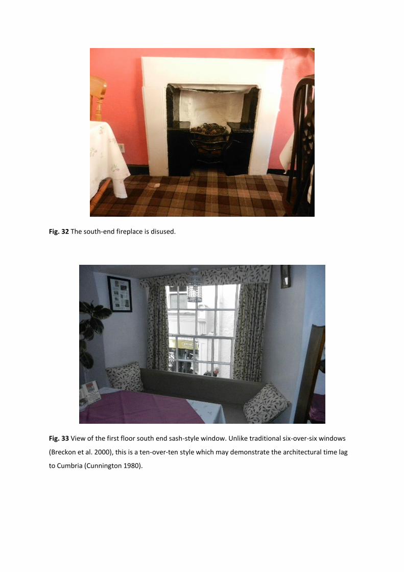
Fig. 32 The south-end fireplace is disused.
Fig. 33 View of the first floor south end sash-style window. Unlike traditional six-over-six windows
(Breckon et al. 2000), this is a ten-over-ten style which may demonstrate the architectural time lag
to Cumbria (Cunnington 1980).

Fig. 34 The interior seating in the oriel window.
Fig. 35 View of the 20th century main door to first floor that would have been the main access from
street to no. 54 in the 19th century.

Fig. 36 The north end first floor window is another ten-over-ten pane sash style window.
Fig. 37 An opening in the wall is situated next to the main fireplace on the first floor. There is one
either side of the fireplace.

Fig. 38 The north end fireplace is disused and has been blocked up.
Fig. 39 The 20th century fire exit door leads out onto the walkway to yard 52, as seen in Fig. 12. This
point of access already existed in architectural plans for the building in the late 1960s (Donald Haigh
Architects 1965-67).

Fig. 40 The first floor kitchen area, was a later alteration internally in the mid-20th century. Original
timber beams are visible under the plaster ceilings.
Fig. 41 The first floor kitchen has panelling near the door that may have blocked up a window that
would have looked out onto yard 52 (Donald Haigh Architects 1965-67). However a later 20th century
development in yard 52, as seen in Fig. 2, has eroded this evidential connection to the yard
(Appendix B).

Fig. 42 The oven in the corner of the kitchen may have been an original feature, but the doric style
neo-classical detailing (Calloway 2012) around it is a later addition.
Fig. 43 A barred up second floor door that leads onto the jetty. The corner window looks out onto
Yard 52 and the winding staircase is situated below this.
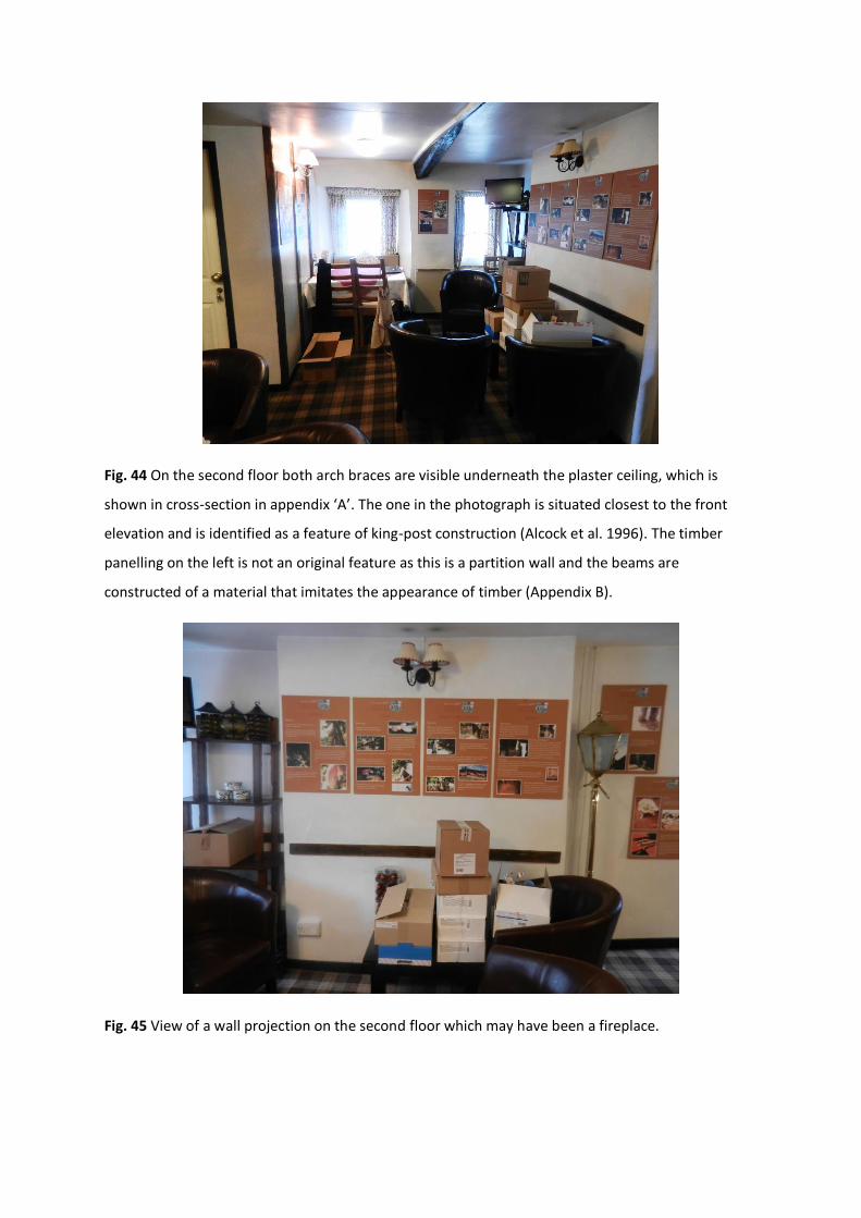
Fig. 44 On the second floor both arch braces are visible underneath the plaster ceiling, which is
shown in cross-section in appendix ‘A’. The one in the photograph is situated closest to the front
elevation and is identified as a feature of king-post construction (Alcock et al. 1996). The timber
panelling on the left is not an original feature as this is a partition wall and the beams are
constructed of a material that imitates the appearance of timber (Appendix B).
Fig. 45 View of a wall projection on the second floor which may have been a fireplace.

Fig. 46 View of the north-end second floor windows.
Fig. 47 View of a small room with later partition walls.

Fig. 48 View of internal distortion and movement of the second floor wall.
Fig. 49 View of an arch brace and notches – an indication of trusses above.

Fig. 50 View of a second floor window overlooking the 20th century development to the back of the
building.
Fig. 51 View of a Georgian neo-classical style door with typically different panel proportions.

Fig. 52 View of a small room with partition walls.
Fig. 53 View of 20th century dividing room – a blocked off doorway is situated at the south end of the
building. It is a simple two-panel door that was common throughout the 18th century for upper floors
and modest dwellings (Calloway 2012).

Fig. 54 View of the main south-end beam with notches
Fig. 55 The south end original timber beam of the building is visible and so is a window overlooking
20th century development at the back.

Fig. 56 View of the current store room on the second floor with a recess onto front elevation, as
shown in appendix ‘A’.
Fig. 57 View of the current office room - an end truss beam has been covered up.
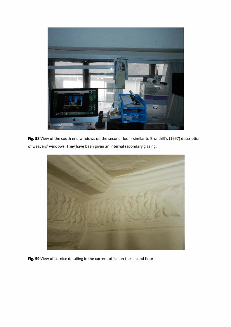
Fig. 58 View of the south end windows on the second floor - similar to Brunskill’s (1997) description
of weavers’ windows. They have been given an internal secondary glazing.
Fig. 59 View of cornice detailing in the current office on the second floor.

Fig. 60 View of king-post truss in the centre of the attic - a very common type of roof construction in
the North West (Harris 1993).
Fig. 61 The south-end truss has been plastered over. The rafters and a purlin are also visible. ‘In a
king-post [construction]…the purlins, generally rather slender in section, are trenched into the
principals’ (Harris 1993: 81).

Fig. 62 Attic view of ridge braces in the roof construction – a feature that was less common than the
king-post truss (Harris 1993).
Fig. 63 View of the ridge brace on the central king-post truss and the pegs also visible.

Fig. 64 The central truss has hinges, suggesting evidence of a door being used in the attic.
5 INTERPRETATION
‘An architectural history can tell its readers what is known and can be known of the past. These are
questions of evidence’ (Leach 2010: 77). The physical evidence of the 1657 Chocolate House has
been greatly eroded (Appendix B) and the intended original purpose of the building’s construction is
not documented. Therefore, this report will offer an informed interpretation of the building’s history
based on the author’s understanding of the historical development of buildings and settlements and
the research undertaken into local historical documents, maps and census information. From the
suggested dating of the 17th century [online] (Historic England), Kendal’s importance as a textile hub
from the 13th until the 18th century (Bingham 1995) and the plan layout (Appendix A) it could be
suggested it was constructed for domestic textile making in the era of proto-industrialisation
(Hudson 1996).
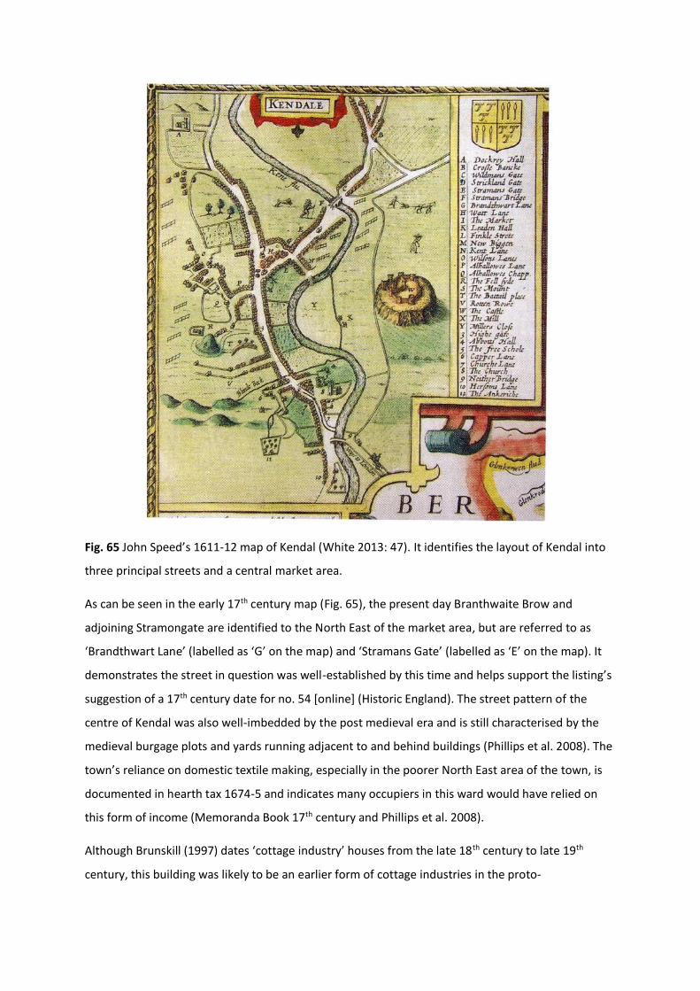
Fig. 65 John Speed’s 1611-12 map of Kendal (White 2013: 47). It identifies the layout of Kendal into
three principal streets and a central market area.
As can be seen in the early 17th century map (Fig. 65), the present day Branthwaite Brow and
adjoining Stramongate are identified to the North East of the market area, but are referred to as
‘Brandthwart Lane’ (labelled as ‘G’ on the map) and ‘Stramans Gate’ (labelled as ‘E’ on the map). It
demonstrates the street in question was well-established by this time and helps support the listing’s
suggestion of a 17th century date for no. 54 [online] (Historic England). The street pattern of the
centre of Kendal was also well-imbedded by the post medieval era and is still characterised by the
medieval burgage plots and yards running adjacent to and behind buildings (Phillips et al. 2008). The
town’s reliance on domestic textile making, especially in the poorer North East area of the town, is
documented in hearth tax 1674-5 and indicates many occupiers in this ward would have relied on
this form of income (Memoranda Book 17th century and Phillips et al. 2008).
Although Brunskill (1997) dates ‘cottage industry’ houses from the late 18th century to late 19th
century, this building was likely to be an earlier form of cottage industries in the proto-

industrialisation era and putting-out system (Hudson 1996). Brunskill’s descriptions of textile cottage
industry buildings matches the arrangement of the 1657 Chocolate House:
‘Probably the most characteristic arrangement is that in which the workroom was placed above the domestic
accommodation. This arrangement is easily recognised by the elongated ‘weavers’ windows’ of archaic pattern
contrasting with the more up-to-date windows of the house…For many textile operations (weaving and frame
knitting, for example), adequate headroom was important and this could be most conveniently obtained on
the top floor. Within the roof space, the ‘cockloft’ immediately under the ridge was used for storage’ (1997:
154).
‘The cellar workshop was most convenient…[in textile areas] where the process required a damp atmosphere.
The cellar was usually only half underground and was approached by steps from an area while other steps led
to the cottage above’ (1997: 156).
As can be seen in the drawn record (Appendix A), the second floor has these weavers’ windows and
is a taller room than the first floor to possibly allow for machinery such as a handloom. In addition,
the ground floor is partially underground and could have been used as a workshop in addition to the
one on the second floor. The arrangement of separate steps and entrances (Fig. 3) also matches
Brunskill’s description. In addition to this, there are two blocked up doors at the gable ends of the
second floor (Fig. 43 and 53), which suggests a previous connection to neighbouring buildings. This
may have been overlooked in appendix ‘B’.
The domestic industries in the pre-industrial period usually involved the contracting of whole
families and households, but in textile manufacture certain members were employed by contractors
for specific jobs: usually women for spinning and men for weaving (Hudson 1996). Additionally, the
putting-out system often relied on cohousing and the communication between workshops to create
an early form of industry clustering (Hudson 1996). In relation to Kendal this is suggested as the
reason for the yard arrangement (Brunskill 2002) and in relation to the Chocolate House this could
be why evidence of a connection to neighbouring buildings exists.
There are many quirks to the Chocolate House’s building materials and architectural style. The
timber-frame has been refaced in limestone rubble, most likely at a later date when the destruction
of fire threatened timber buildings of the town in 1698 (White 2013). The sash-style and oriel
windows of the first floor (Fig. 3, 18, 33 and 36) were likely to have been added at a later date
because they sit in front of the timber frame and are characteristic of later styles from the 18th
century (Breckon et al. 2000). These changes also indicate that the first floor may have become a
domestic parlour in the 18th century, which is further demonstrated by other neo-classical
architectural features (Fig. 25, 42, 51 and 53).

Fig. 66 1860s OS map of Kendal (1: 1250), 54 and 56 Branthwaite Brow are highlighted in red [online]
(Digimap)
The building and its surroundings have undergone many changes since the 17th century. The 19th
century census information and OS maps of the building identify it as two separate buildings (Fig.
66): no. 54 was the first and second floors, no. 56 was the ground floor. The reason for the building’s
division is unrecorded, but the area of Stramongate was the poorest in medieval and post-medieval
Kendal (Bingham 1995). When the hearth tax was introduced 1674-5 many people of this ward were
either exempt from the tax or divided their building into separate dwellings to avoid multi-hearth
taxation (Phillips et al. 2008). It is possible that the latter occurred to the building. The various
occupiers of the 19th century were recorded to have continued the use of the building as workshops
for craft and trade - shoemaker, dressmaker, labourer, baker, and confectioner - however not for
textile making (Nicholls 2008). This may have been due to Kendal’s domestic textile industry dying
out by the mid-18th century (Bingham 1995 and Brunskill 2002). There is also archival evidence that a
pantry (Fig. 67) was attached to no.54 (what is now the first floor), but this was removed in the late
1960s due to a later development in yard 52 (Donald Haigh Architects 1965-7).
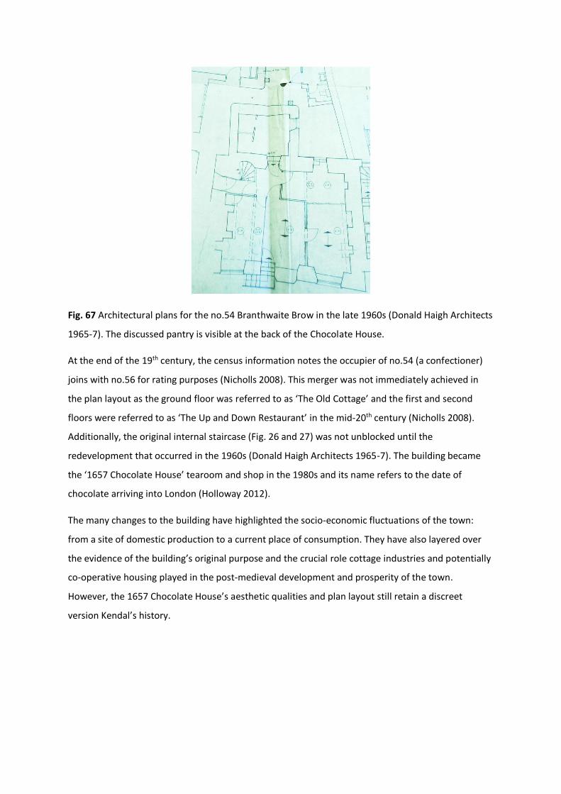
Fig. 67 Architectural plans for the no.54 Branthwaite Brow in the late 1960s (Donald Haigh Architects
1965-7). The discussed pantry is visible at the back of the Chocolate House.
At the end of the 19th century, the census information notes the occupier of no.54 (a confectioner)
joins with no.56 for rating purposes (Nicholls 2008). This merger was not immediately achieved in
the plan layout as the ground floor was referred to as ‘The Old Cottage’ and the first and second
floors were referred to as ‘The Up and Down Restaurant’ in the mid-20th century (Nicholls 2008).
Additionally, the original internal staircase (Fig. 26 and 27) was not unblocked until the
redevelopment that occurred in the 1960s (Donald Haigh Architects 1965-7). The building became
the ‘1657 Chocolate House’ tearoom and shop in the 1980s and its name refers to the date of
chocolate arriving into London (Holloway 2012).
The many changes to the building have highlighted the socio-economic fluctuations of the town:
from a site of domestic production to a current place of consumption. They have also layered over
the evidence of the building’s original purpose and the crucial role cottage industries and potentially
co-operative housing played in the post-medieval development and prosperity of the town.
However, the 1657 Chocolate House’s aesthetic qualities and plan layout still retain a discreet
version Kendal’s history.

6 BIBLIOGRAPHY
Alcock, N.W., Barley, M.W., Dixon, P.W. and Meeson, R.A. (1996) Recording Timber-Framed
Buildings: An Illustrated Glossary, Council for British Archaeology: London
Bingham, R.K. (1995) Kendal: A Social History, Cicerone Press: Milnthorpe
Breckon, B., Parker, J. and Andrew, M. (2000) Tracing the History of Houses, Countryside Books:
Berkshire
Brunskill, R.W. (1997) Houses and Cottages of Britain: Origins and Development of Traditional
Buildings, Yale University Press: London
Brunskill, R.W. (2002) Traditional Buildings of Cumbria: The County of the Lakes, Yale University
Press: London
Calloway, S. (2012) The Elements of Style: an encyclopaedia of domestic architectural detail (4th
edition), Octopus Publishing Group: London
Cunnington, P. (1980) How Old is Your House?, Alphabooks: Dorset
Digimap [online] Present Day OS Map(s) of Kendal Town Centre, Found at:
http://digimap.edina.ac.uk/roam/os [Date Accessed 13th March 2015]
Donald Haigh Architects (1965-7) Architectural plans of proposed alterations for 54 Brantwaite
Brow and 2 Stramongate, including Local Planning Authority approval documents, Found at: Kendal
Archives, Ref: WSMBK/11/4/5461
Glancey, J. (2000) The Story of Architecture, Dorling Kindersley: London
Harris, R. (1993) Discovering Timber-Framed Buildings, Shire Publications Ltd: Oxford
Historic England (2006) Understanding Historic Buildings: A Guide to Good Recording Practice
Historic England [online] No. 54/56 Branthwaite Brow listing entry, Found at:
http://list.historicengland.org.uk/resultsingle.aspx?uid=1145660&searchtype=mapsearch [Date
Accessed 16th April 2015]
Historic England [online] No. 50 Branthwaite Brow and Yard 52 listing, Found at:
http://list.historicengland.org.uk/resultsingle.aspx?uid=1145659&searchtype=mapsearch [Date
Accessed 6th May 2015]
Holloway, N. (2012) Kendal Through Time, Amberley Publishing: Stroud
Hudson, P. (1996) Proto-industrialisation in England, in Sheilagh, C. and Cerman, M. (eds) European
proto-industrialisation, Cambridge University Press: London
Leach, A. (2010) What is Architectural History?, Polity Press: Cambridge
Memoranda Book (17th Century) ‘A survey of all the Fire hearths and stoves in the County of
Westmorland…Taken after Michaelmas, Anno Domini 1674’ pp. 1-112, Found at: Kendal Archives,
Ref: WDRY/4/4/4/10
Nicholls, A.R. (2008) Cast iron, beer and chocolate: A story of Branthwaite Brow, Kendal, Found at
Local History Reference, Kendal Library, Ref: W42(9) NIC
Phillips, C., Ferguson, C. and Wareham, A. (2008) Westmorland Hearth Tax, British Read Society and
Cumberland and Westmorland Antiquarian and Archaeological Society: Carlisle
White, A. (2013) A History of Kendal, Carnegie Publishing Ltd: Lancaster
Yarwood, D. (1993) Encyclopaedia of Architecture, Batsford Ltd: London

7 APPENDICES
7.1 APPENDIX ‘A’ – DRAWN RECORD
Front Elevation

North-facing Cross Section

Ground Floor Layout

First Floor Layout

Second Floor Layout
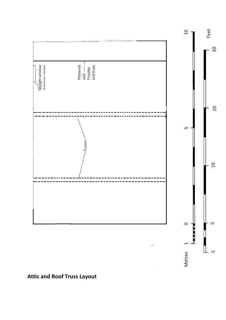
Attic and Roof Truss Layout

7.2 APPENDIX ‘B’ – HERITAGE STATEMENT OF SIGNIFICANCE (ATKINSON 2015)
Heritage Statement of Significance
The 1657 Chocolate House,
54 Branthwaite Brow, Kendal, Cumbria
LA9 4TX
Listing NGR: SD5162892765
Prepared by
Megan Atkinson
March 2015

Contents
8. Introduction
9. General Description
10. Assessment and Statement of Significance
11. Figures
12. Bibliography

8 INTRODUCTION
8.1 PURPOSE
There are currently no established proposals for change at the grade II listed 1657 Chocolate House.
The report will assess and summarise the heritage values in a statement of significance which can
instead be used for future proposals. The document has been prepared in accordance with English
Heritage’s (2008) Conservation Principles, Policies and Guidance and the guidelines offered in the
2012 National Planning Policy Framework (NPPF).
8.2 AUTHOR
Megan Atkinson, the author, is currently studying for an Msc in Building Conservation and
Regeneration.
8.3 METHODS OF RESEARCH AND INVESTIGATION
In order to assess the physical features and character of the building, inspections of the property
were carried out in March 2015. In accordance with English Heritage’s guidelines (2006 and 2008),
background research was also conducted to help fully understand the nature of the building. The
level of research cannot be proportionate to the level of proposed works as this statement of
significance is not produced in a situation of change. It will, therefore, undertake a detailed
investigation into the site and emphasise its historic and architectural interest.
9 GENERAL DESCRIPTION
9.1 SITE LOCATION
The 1657 Chocolate House is located at National Grid reference SD 51628 92765, no. 54 (previously
54/56) Branthwaite Brow within the town centre and Conservation Area of Kendal, Cumbria (Fig. 1
and 2).
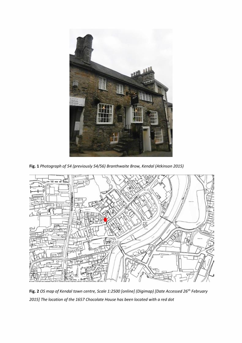
Fig. 1 Photograph of 54 (previously 54/56) Branthwaite Brow, Kendal (Atkinson 2015)
Fig. 2 OS map of Kendal town centre, Scale 1:2500 [online] (Digimap) [Date Accessed 26th February
2015] The location of the 1657 Chocolate House has been located with a red dot
Stri
ckla
nd
gate
Hig
hga
te

9.2 LOCATION’S DEVELOPMENT
Kendal is a town situated in South Cumbria, in a county previously known as Westmorland (Phillips
et al. 2008). Its market began as early as 1189 (Letters 2005) and is the town’s strongest living links
with the Middle Ages (Bingham 1995). The settlement developed its characteristic burgage plot
layout along three main medieval streets – Stricklandgate, Highgate and Stramongate (Fig. 2). Many
buildings are accompanied by ‘yards’ or narrow passages that were crucial ‘during Kendal’s long
period of eminence as a textile centre’ (Brunskill 2002: 134).
By the time of the hearth tax 1674-75, Kendal’s street pattern was already ancient and the town
‘was the centre of Westmorland cloth industry’ (Phillips et al. 2008: 14). The early forms of textile
making began as a domestic activity where weavers were packed into cottages (Brunskill 2002). Its
importance is reflected in the town motto – Pannus Mihi Panis – meaning ‘Wool (or cloth) is our
Bread’ and the naming of numerous buildings and streets after different processes of wool
production (Bingham 1995).
Although there was some continuation of domestic industries into the 19th century, industrialisation
led to the design of factory buildings (Brunskill 2002), the consequent growth of snuff and
shoemaking industries and the movement away of production to industrial sites (Bingham 1995).
Today, Kendal is considered a market town and the tradition continues at the top of Branthwaite
Brow (Fig 3). But many industries, as seen in other towns, have been outsourced and the main
streets are now characterised by shops and cafes.
Important local features include the scheduled monument of the ruins of the 13th century Kendal
Castle and the Grade I listed 14th century Castle Dairy.

Fig. 3 OS Map (1: 500) of Branthwaite Brow, the Market Place and Stramongate. The Chocolate
House is outlined in blue at no. 54 [online] (Digimap)
9.3 SITE DESCRIPTION
The Chocolate House is situated on a cobble stoned street named Branthwaite Brow (Fig. 4), which
means ‘steep road’ (Holloway 2012). The top of Branthwaite Brow connects to Kendal market place
and the bottom connects to one of the three main medieval streets – Stramongate (Fig. 3).

Fig. 4 Photograph of Branthwaite Brow, Kendal – the Chocolate House is visible on the right (Atkinson
2015)
9.4 BUILDING DESCRIPTION
Unlike surrounding medieval burgage plots (Fig. 2 and 3), the grade II listed Chocolate House is a
single pile, three storey building that faces west onto Branthwaite Brow. It has king-post timber
frame construction (Fig. 5 and 6), which ‘are extremely common in the north in medieval and post-
medieval buildings’ (Harris 1993: 81). It has been refaced in rough limestone rubble, which is again
characteristic of Cumbria’s vernacular buildings due to the surrounding geology (Brunskill 2002). It
has a graduated slate roof and two chimney stacks at either gable end (though the fireplaces are no
longer in use) (Fig. 7 and 8). Although the listing states there are 4 bays, there are only 3. Due to the
steepness of the street the ground floor has a smaller floor plan than the other two storeys. Outdoor
steps lead up to the first floor and a separate door exists to the ground floor, but there are adjoining
internal stairs between the three storeys. The adjoining staircase between the ground and first floor
is likely to be original as it is a semi-circular timber winding staircase located next to the chimney
stack (Fig. 9), which were often found in 16th and 17th century cottages (Cunnington 1980). In
addition, the building is situated next to the entrance to yard 52 (Fig. 10) which is grade II listed as
part of No. 50 [online] (English Heritage). There are later alterations to the building, such as the

introduction of sash-style and bay windows, 20th century entrance doors and the replacement of
some supporting timber posts. Additionally, 20th century alterations to neighbouring buildings have
blocked up yard 52 and rear access to the first floor of the Chocolate House.
Fig. 5 Photograph of the Chocolate House’s king-post truss and ridge brace (Atkinson 2015) ‘In a
king-post truss a stout post rises from the tie beam to give direct support to the ridge of the roof’
(Harris 1993: 81)
Fig. 6 Diagram of a king-post truss, which was a common form of timber construction seen only in
northern England in the 15th to 17th centuries. Due to the influence of pattern books, this construction
method was adopted elsewhere in England from the 18th and 19th centuries (Harris 1993: 78)
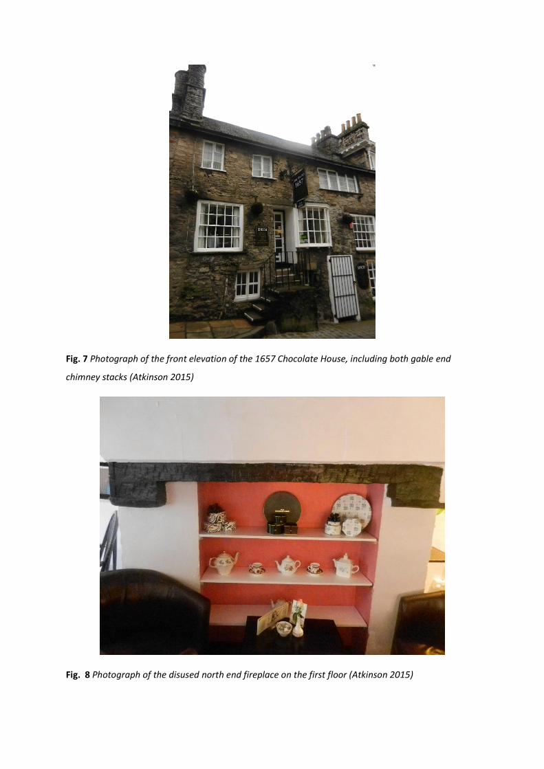
Fig. 7 Photograph of the front elevation of the 1657 Chocolate House, including both gable end
chimney stacks (Atkinson 2015)
Fig. 8 Photograph of the disused north end fireplace on the first floor (Atkinson 2015)
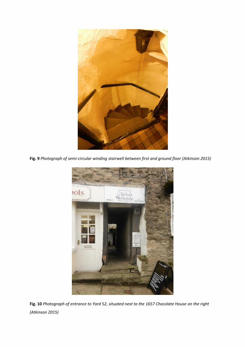
Fig. 9 Photograph of semi-circular winding stairwell between first and ground floor (Atkinson 2015)
Fig. 10 Photograph of entrance to Yard 52, situated next to the 1657 Chocolate House on the right
(Atkinson 2015)

9.5 LISTING DESCRIPTION
Grade: II
Date first listed: 14th April 1969
SD 5192 NE KENDAL MARKET PLACE (BRANTHWAITE BROW, East side)
No 54/56 (numbers not 8/118 clearly assigned) 14-4-69 G.V. II
2 shops, one above the other, on sloping site. C17; later additions and alterations. Coursed, squared
rubble, battered to south end; slobbered. Moulded cast-iron gutter. Graduated slate roof; stone end
chimneys (north has rounded corners). 3 storeys overall, 4 bays. Lower shop on right: Recessed C20
door (with contemporary iron grille in front); small fixed window to left and bow window to right,
both with glazing bars. 2-light wood-mullioned casement to left of stone steps to upper shop's (lst
floor) entrance: Recessed C20 glazed door with bay window on brackets immediately to right; sash to
left and to far right. 3 wood-mullioned casements to 2nd floor of 2 , 3 and 4 lights; wrought-iron
bracket between middle and right-hand windows supports C20 sign.
10 ASSESSMENT AND STATEMENT OF SIGNIFICANCE
10.1 HISTORIC BACKGROUND
The Chocolate House has a complicated and allusive history and it must be recognised that ‘not
everything gets recorded and even less survives. Inevitably this skews our picture of the past’
(McLean 2007: 26). Nonetheless, the king-post roof construction and adjoining original staircase
indicate it was built as one house most probably in the 17th century. Due to the suggested period of
its construction, the uncharacteristic plan form when compared to surrounding buildings and its
connection to Yard 52, the building may have been connected to domestic textile making. As noted
in the hearth tax 1674-5, many residents in the area of Stramongate relied on income from cloth
making (Phillips et al. 2008) as this was the poorest area (Memoranda Book 17th century). As a result
of low prosperity, many houses were exempt from the tax or alternatively the properties were
divided to avoid multi-hearth taxation (Phillips et al. 2008). It could be suggested the latter occurred
to the building because by the time of the census and OS maps of the early 19th century it is
identified as two separate buildings (no. 54 and 56) (Fig. 11).
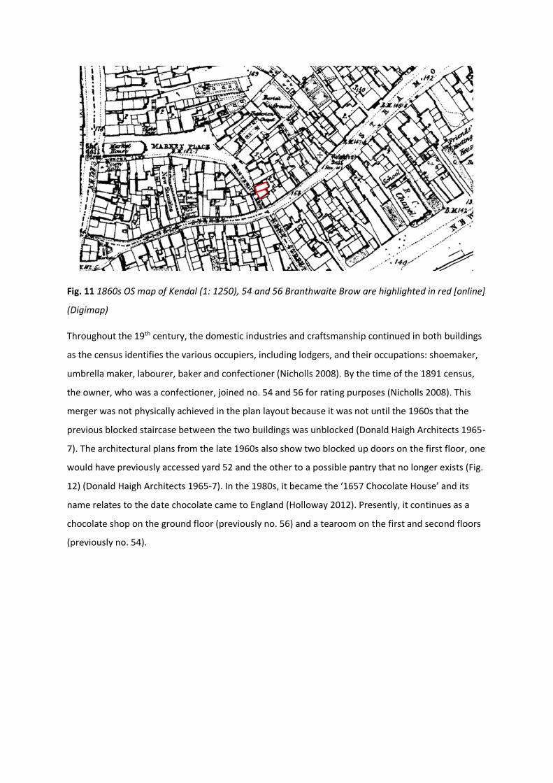
Fig. 11 1860s OS map of Kendal (1: 1250), 54 and 56 Branthwaite Brow are highlighted in red [online]
(Digimap)
Throughout the 19th century, the domestic industries and craftsmanship continued in both buildings
as the census identifies the various occupiers, including lodgers, and their occupations: shoemaker,
umbrella maker, labourer, baker and confectioner (Nicholls 2008). By the time of the 1891 census,
the owner, who was a confectioner, joined no. 54 and 56 for rating purposes (Nicholls 2008). This
merger was not physically achieved in the plan layout because it was not until the 1960s that the
previous blocked staircase between the two buildings was unblocked (Donald Haigh Architects 1965-
7). The architectural plans from the late 1960s also show two blocked up doors on the first floor, one
would have previously accessed yard 52 and the other to a possible pantry that no longer exists (Fig.
12) (Donald Haigh Architects 1965-7). In the 1980s, it became the ‘1657 Chocolate House’ and its
name relates to the date chocolate came to England (Holloway 2012). Presently, it continues as a
chocolate shop on the ground floor (previously no. 56) and a tearoom on the first and second floors
(previously no. 54).
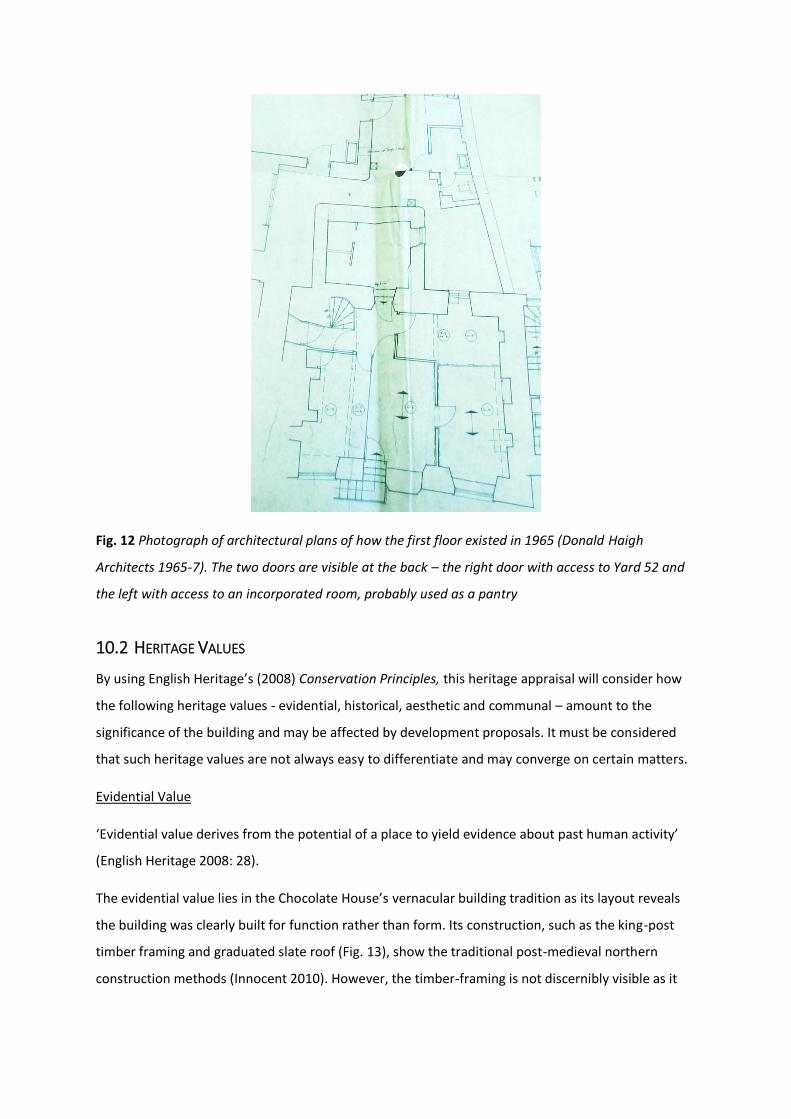
Fig. 12 Photograph of architectural plans of how the first floor existed in 1965 (Donald Haigh
Architects 1965-7). The two doors are visible at the back – the right door with access to Yard 52 and
the left with access to an incorporated room, probably used as a pantry
10.2 HERITAGE VALUES
By using English Heritage’s (2008) Conservation Principles, this heritage appraisal will consider how
the following heritage values - evidential, historical, aesthetic and communal – amount to the
significance of the building and may be affected by development proposals. It must be considered
that such heritage values are not always easy to differentiate and may converge on certain matters.
Evidential Value
‘Evidential value derives from the potential of a place to yield evidence about past human activity’
(English Heritage 2008: 28).
The evidential value lies in the Chocolate House’s vernacular building tradition as its layout reveals
the building was clearly built for function rather than form. Its construction, such as the king-post
timber framing and graduated slate roof (Fig. 13), show the traditional post-medieval northern
construction methods (Innocent 2010). However, the timber-framing is not discernibly visible as it

has been refaced in limestone rubble, most likely at a later date, and concealed by plaster ceilings
except for the principal bay beams and posts (Fig. 14).
Fig. 13 Photograph of the slate roofing and gable end chimney stacks (Atkinson 2015)
Fig. 14 Photograph of exposed principal timber beams and plasterwork of the ceiling on the first floor
(Atkinson 2015)

Later alterations such as the addition of Georgian style windows and 20th century entrance doors
have significantly eroded the evidential value of the building’s ‘authenticity’, as it shows the later
influence of polite architecture on the vernacular tradition (Brunskill 2000). Furthermore, access to
the back of the building has been blocked up and subsequently has diminished the potential to
understand and interpret the connection to yard 52 and evidence inherited from the past (Fig. 15).
Nonetheless, the reuse of the traditional staircase (that was previously blocked up) between the two
buildings brings greater evidence than when it was listed in 1969 because it increases the integrity
and honesty of the building’s layout.
Fig. 15 Photograph of present day Yard 52 (Atkinson 2015). The pebble-dash building on the right is
an extension built in the 1960s/70s, which has removed the possible pantry seen in Fig. 12 and blocks
up evidence of the rear access to the Chocolate House and its connection to the yard
Historical Value
‘Historical value derives from the ways in which past people, events and aspects of life can be
connected through a place to the present. It tends to be illustrative or associative’ (English Heritage
2008: 28).
The building has been designated a historic asset for the way it retains historic fabric and therefore
contributes to the illustrative understanding of how Kendal and its people have developed over
time. There are no obvious associations to specific people or events, but the building’s vernacular
construction, plan form and suggested history of domestic industry creates associative connections
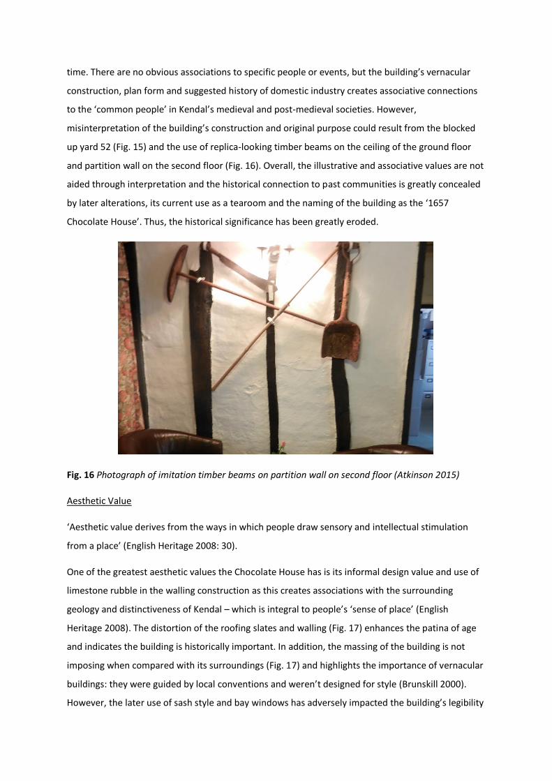
to the ‘common people’ in Kendal’s medieval and post-medieval societies. However,
misinterpretation of the building’s construction and original purpose could result from the blocked
up yard 52 (Fig. 15) and the use of replica-looking timber beams on the ceiling of the ground floor
and partition wall on the second floor (Fig. 16). Overall, the illustrative and associative values are not
aided through interpretation and the historical connection to past communities is greatly concealed
by later alterations, its current use as a tearoom and the naming of the building as the ‘1657
Chocolate House’. Thus, the historical significance has been greatly eroded.
Fig. 16 Photograph of imitation timber beams on partition wall on second floor (Atkinson 2015)
Aesthetic Value
‘Aesthetic value derives from the ways in which people draw sensory and intellectual stimulation
from a place’ (English Heritage 2008: 30).
One of the greatest aesthetic values the Chocolate House has is its informal design value and use of
limestone rubble in the walling construction as this creates associations with the surrounding
geology and distinctiveness of Kendal – which is integral to people’s ‘sense of place’ (English
Heritage 2008). The distortion of the roofing slates and walling (Fig. 17) enhances the patina of age
and indicates the building is historically important. In addition, the massing of the building is not
imposing when compared with its surroundings (Fig. 17) and highlights the importance of vernacular
buildings: they were guided by local conventions and weren’t designed for style (Brunskill 2000).
However, the later use of sash style and bay windows has adversely impacted the building’s legibility
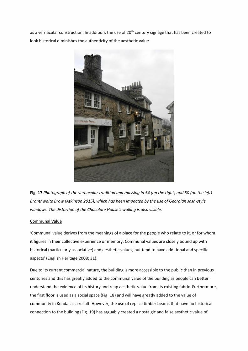
as a vernacular construction. In addition, the use of 20th century signage that has been created to
look historical diminishes the authenticity of the aesthetic value.
Fig. 17 Photograph of the vernacular tradition and massing in 54 (on the right) and 50 (on the left)
Branthwaite Brow (Atkinson 2015), which has been impacted by the use of Georgian sash-style
windows. The distortion of the Chocolate House’s walling is also visible.
Communal Value
‘Communal value derives from the meanings of a place for the people who relate to it, or for whom
it figures in their collective experience or memory. Communal values are closely bound up with
historical (particularly associative) and aesthetic values, but tend to have additional and specific
aspects’ (English Heritage 2008: 31).
Due to its current commercial nature, the building is more accessible to the public than in previous
centuries and this has greatly added to the communal value of the building as people can better
understand the evidence of its history and reap aesthetic value from its existing fabric. Furthermore,
the first floor is used as a social space (Fig. 18) and will have greatly added to the value of
community in Kendal as a result. However, the use of replica timber beams that have no historical
connection to the building (Fig. 19) has arguably created a nostalgic and false aesthetic value of
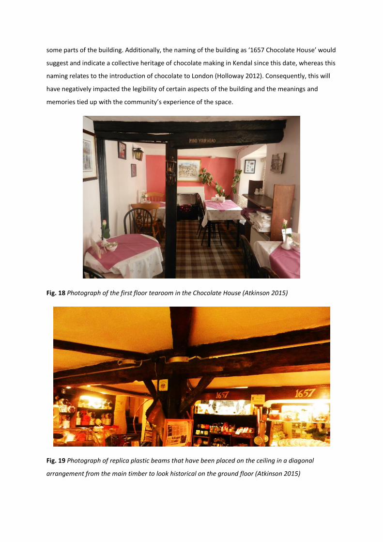
some parts of the building. Additionally, the naming of the building as ‘1657 Chocolate House’ would
suggest and indicate a collective heritage of chocolate making in Kendal since this date, whereas this
naming relates to the introduction of chocolate to London (Holloway 2012). Consequently, this will
have negatively impacted the legibility of certain aspects of the building and the meanings and
memories tied up with the community’s experience of the space.
Fig. 18 Photograph of the first floor tearoom in the Chocolate House (Atkinson 2015)
Fig. 19 Photograph of replica plastic beams that have been placed on the ceiling in a diagonal
arrangement from the main timber to look historical on the ground floor (Atkinson 2015)

10.3 STATEMENT OF SIGNIFICANCE
The appraisal of the heritage values associated with the 1657 Chocolate House has helped reveal
where its significance is weighted most. The building’s main values lie in its vernacular building
tradition and the way it contributes to the character of Kendal. The aesthetic value will be of great
importance to many people – drawing sensory experience from its patina of age and relation to the
local built environment. In comparison, its evidential value has been greatly reduced by a divided
history, later external additions and significant alterations to the interior. This has subsequently
adversely impacted the historical and communal values by creating a misinterpretation of the
building. Nonetheless, as Brunskill remarks ‘[t]he true flavour of Kendal resides in the
surviving…cottages in the yards with their rough limestone walls and Lake District slate roofs’ (2002:
137). Therefore, the Chocolate House’s absence of unique evidence and contribution to people’s
understanding of the past is compensated by its influence on the collective identity of Kendal’s built
environment and ‘sense of place’.
Although there is little scope for redevelopment and extension of the building due to the compact
settlement plan, the significance of the 1657 Chocolate House should be conserved as it is listed and
lies within a Conservation Area. This can be achieved by keeping in in line with Section 12 policies of
the NPPF (DCLG 2012) and the following principles:
Use traditional methods to repair or replace any external elements – create ‘like for like’ and
respect the surrounding local distinctiveness and massing
Interior alterations and divisions do not need to be as carefully managed as there have
already been significant changes to this in the past
Consider the removal of imitation timber beams that have no connection to the building’s
construction
Consider offering an interpretation of the building’s history (bearing in mind the limited
evidential and written records), so as not to adversely impact the historical and communal
values
Word Count: 2493

11 FIGURES
1. Photograph of 54 (previously 54/56) Branthwaite Brow, Kendal (Atkinson 2015)
2. Map of Kendal town centre [online] (Digimap) [Date Accessed 26th February 2015]
3. OS Map (1: 500) of Branthwaite Brow, the Market Place and Stramongate. The Chocolate
House is outlined in blue at no. 54 [online] (Digimap)
4. Photograph of Branthwaite Brow, Kendal – the Chocolate House is visible on the right
(Atkinson 2015)
5. Photograph of the king-post truss and brace (Atkinson 2015)
6. Diagram of king-post truss (Harris 1993: 78)
7. Photograph of the front elevation of the Chocolate House, including the gable end chimney
stacks (Atkinson 2015)
8. Photograph of disused north fireplace on the first floor (Atkinson 2015)
9. Photograph of the semi-circular newel staircase between the first and second floor (Atkinson
2015)
10. Photograph of the entrance to Yard 52, situated next the 1657 Chocolate House (Atkinson
2015)
11. 1860s OS Map of Kendal (1: 2500) [online] (Digimap)
12. Photograph of architectural plans of how the first floor existed in 1965 (Donald Haigh
Architects 1965-7)
13. Photograph of the slate roofing and gable end chimney stacks (Atkinson 2015)
14. Photograph of the exposed principal timber beam and plasterwork on the ceiling of the first
floor (Atkinson 2015)
15. Photograph of present day Yard 52 (Atkinson 2015)
16. Photograph of the imitation timber beams on a second floor partition wall (Atkinson 2015)
17. Photograph of vernacular walling tradition and massing of no. 50 (on the left) and 54
Branthwaite Brow (Atkinson 2015)
18. Photograph of the first floor tearoom (Atkinson 2015)
19. Photograph of replica beams on the ground floor ceiling (Atkinson 2015)

12 BIBLIOGRAPHY
Bingham, R.K. (1995) Kendal: A Social History, Cicerone Press: Milnthorpe
Brunskill, R.W. (2000) Vernacular Architecture: An Illustrated Handbook, Faber and Faber Limited:
London
Brunskill, R.W. (2002) Traditional Buildings of Cumbria: the county of the Lakes, Yale University
Press: London
Cunnington, P. (1980) How Old is Your House?, Alphabooks: Dorset
English Heritage [online] Listing NGR: SD 51628 92765 (54/56 Branthwaite Brow), Found at:
http://list.english-heritage.org.uk/resultsingle.aspx?uid=1145660&searchtype=mapsearch [Date
Accessed 13th March 2015]
English Heritage [online] Listing NGR: SD5162592772 (50 Branthwaite Brow and Entrance to Yard
52), Found at: http://list.english-
heritage.org.uk/resultsingle.aspx?uid=1145659&searchtype=mapsearch [Date Accessed 15th March]
English Heritage (2006) Understanding Historic Buildings: a guide to good recording practice
English Heritage (2008) Conservation Principles, Policies and Guidance: Sustainable Management of
the Historic Environment
Department of Communities and Local Government (2012) National Planning Policy Framework,
Found at:
https://www.gov.uk/government/uploads/system/uploads/attachment_data/file/6077/2116950.pd
f [Date Accessed 27th February 2015]
Digimap [online] Present Day OS Map(s) of Kendal Town Centre, Found at:
http://digimap.edina.ac.uk/roam/os [Date Accessed 13th March 2015]
Digimap [online] 1860s OS Map of Kendal Town Centre, Found at:
http://digimap.edina.ac.uk/ancientroam/historic [Date Accessed 25th February 2015]
Donald Haigh Architects (1965-7) Architectural plans of proposed alterations for 54 Brantwaite
Brow and 2 Stramongate, including Local Planning Authority approval documents, Found at: Kendal
Archives, Ref: WSMBK/11/4/5461
Harris, R. (1993) Discovering Timber-Framed Buildings, Shire Publications Ltd: Oxford

Holloway, N. (2012) Kendal Through Time, Amberley Publishing: Stroud
Innocent, C.F. (2010) The Development of English Building Construction, Cambridge University Press:
Cambridge
Letters, S. (2005) Westmorland, Gazetteer of Markets and Fairs in England and Wales To 1516, List
and Index Society: Kew, Found at: http://www.british-history.ac.uk/list-index-soc/markets-fairs-
gazetteer-to-1516/westmorland [Date Accessed 26th February 2015]
Memoranda Book (17th Century) ‘A survey of all the Fire hearths and stoves in the County of
Westmorland…Taken after Michaelmas, Anno Domini 1674’ pp. 1-112, Found at: Kendal Archives,
Ref: WDRY/4/4/4/10
McLean, G. (2007) How to do local history: a guide for historians and clients, Otago University Press:
Dunedin
Phillips, C., Ferguson, C. and Wareham, A. (2008) Westmorland Hearth Tax, British Read Society and
Cumberland and Westmorland Antiquarian and Archaeological Society: Carlisle
Nicholls, A.R. (2008) Cast iron, beer and chocolate: A story of Branthwaite Brow, Kendal, Found at
Local History Reference, Kendal Library, Ref: W42(9) NIC