May 5, 2021 Type of Approx. size Latitude & Vol. Rem ...
25
West Virginia Voluntary Remediation Sites May 5, 2021 PROJECT SITE Location Applicant Approx. size in acres Latitude & Longitude Vol. Rem. Project # Project Manager Certificate of Completion Date 1 Certificate of Completion Acreage Type of Institutional Control 2 Nature of Contaminants 1 FMC - South Charleston (East Plant) - Reopened 333 MacCorkle Ave., South Charleston FMC Corporation 26.10 38 o 22' 11.9" N, 81 o 41' 36.4" W 02234 Long Chemical Plant Area 1 & 1A (3.80) Area 2A (3.77) 8/19/2020 3.77 Land Use Covenant Area 2B (1.74) Area 3 (10.44) Area 7 (4.88) Brownfield Way (1.47) 9/26/2012 1.47 Land Use Covenant Substation Area (0.23) 2 Ashland Oil (Burton - McClure) Madison Creek Rd., West Hamlin Wiley and Nowlan, Ashland Oil Agents, Inc. 2.00 38 o 16' 18" N, 82 o 12' 13" W 02235 Hancock Petroleum Burton Parcel (1.00) 02235-B July 2006 1.00 Land Use Covenant McClure Parcel (1.00) 02235-M July 2006 1.00 Land Use Covenant W 4/26/2017 Kanawha Transit 1550 4th Ave., Charleston Kanawha Valley Regional Transit Authority 02236 91-9907-L20 Meeks Petroleum 3 Kohler (Sterling Faucet) 2001 Earl Core Rd., Morgantown ECR Investment Group, LLC; Kohler Company; and Rockwell International Corporation 35.81 39 o 37' 05.3" N, 79 o 55' 24.5" W 02238 Brittain Metal Fabrication Area A (2.34) 02238-A October 2001 2.34 Land Use Covenant Area B (6.84) 02238-B May 2002 6.84 Land Use Covenant Area C (5.43) 02238-C December 2001 5.43 Land Use Covenant Area D (21.20) 02238-D May 2002 21.20 Land Use Covenant 4 Poor Charlie's - Campbell's Creek 141 Campbell's Creek Rd., Charleston Poor Charlie & Company 6.56 38 o 18' 38" N, 81 o 33' 08" W 02239 Meeks June 2006 6.56 Land Use Covenant Salvage Yard W 10/31/2006 LB Foster Washington LB Foster Company 02240 Hancock 5 Century Lubricants 120 West 13th St., Huntington Fuchs Lubricants Company 3.50 38 o 24' 54" N, 82 o 28' 47" W 02241 Hancock January 2007 3.50 Land Use Covenant Petroleum Page 1
Transcript of May 5, 2021 Type of Approx. size Latitude & Vol. Rem ...

West Virginia Voluntary Remediation Sites
May 5, 2021
PROJECT SITE Location ApplicantApprox. size
in acres
Latitude &
Longitude
Vol. Rem.
Project #
Project
Manager
Certificate of
Completion Date1
Certificate of
Completion Acreage
Type of
Institutional
Control2
Nature of
Contaminants
1FMC - South Charleston (East Plant) -
Reopened
333 MacCorkle Ave.,
South CharlestonFMC Corporation 26.10
38o 22' 11.9" N,
81o 41' 36.4" W
02234 Long Chemical Plant
Area 1 & 1A (3.80)
Area 2A (3.77) 8/19/2020 3.77 Land Use Covenant
Area 2B (1.74)
Area 3 (10.44)
Area 7 (4.88)
Brownfield Way (1.47) 9/26/2012 1.47 Land Use Covenant
Substation Area (0.23)
2 Ashland Oil (Burton - McClure)Madison Creek Rd.,
West Hamlin
Wiley and Nowlan,
Ashland Oil Agents, Inc. 2.00
38o 16' 18" N,
82o 12' 13" W
02235 Hancock Petroleum
Burton Parcel (1.00) 02235-B July 2006 1.00 Land Use Covenant
McClure Parcel (1.00) 02235-M July 2006 1.00 Land Use Covenant
W
4/26/2017Kanawha Transit
1550 4th Ave.,
Charleston
Kanawha Valley Regional
Transit Authority
02236
91-9907-L20Meeks Petroleum
3 Kohler (Sterling Faucet) 2001 Earl Core Rd.,
Morgantown
ECR Investment Group,
LLC; Kohler Company;
and Rockwell
International Corporation
35.8139
o 37' 05.3" N,
79o 55' 24.5" W
02238 Brittain Metal Fabrication
Area A (2.34) 02238-A October 2001 2.34 Land Use Covenant
Area B (6.84) 02238-B May 2002 6.84 Land Use Covenant
Area C (5.43) 02238-C December 2001 5.43 Land Use Covenant
Area D (21.20) 02238-D May 2002 21.20 Land Use Covenant
4 Poor Charlie's - Campbell's Creek 141 Campbell's Creek Rd.,
CharlestonPoor Charlie & Company 6.56
38o 18' 38" N,
81o 33' 08" W
02239 Meeks June 2006 6.56 Land Use Covenant Salvage Yard
W
10/31/2006LB Foster Washington LB Foster Company 02240 Hancock
5 Century Lubricants120 West 13th St.,
Huntington
Fuchs Lubricants
Company3.50
38o 24' 54" N,
82o 28' 47" W
02241 Hancock January 2007 3.50 Land Use Covenant Petroleum
Page 1

West Virginia Voluntary Remediation Sites
May 5, 2021
PROJECT SITE Location ApplicantApprox. size
in acres
Latitude &
Longitude
Vol. Rem.
Project #
Project
Manager
Certificate of
Completion Date1
Certificate of
Completion Acreage
Type of
Institutional
Control2
Nature of
Contaminants
W
1/1/2009Jay's Grocery
U.S. Rt. 19,
KegleyBlue Flash Oil, Inc. 02242 Sutphin
6 Amherst Industries - Kanawha Co.14989 MacCorkle Ave.,
Chelyan
Amherst Industries, Inc.
and PC West Virginia
Synthetic Fuel #1, LLC
4.8538
o 11' 50" N,
81o 30' 25" W
02337 Meeks June 2001 4.85 Land Use Covenant Petroleum
7 Eagle Convex423 Tuna St.,
ClarksburgEagle Convex 7.78
39o 16' 19" N,
80o 19' 09"W
02351 Brittain February 1999 7.78 Land Use Covenant Glass Manufacturing
8 CSX - Benwood22nd St.,
BenwoodCSX 58.62
40o 00' 10" N,
80o 44' 06" W
02421 Gadd Railroad Yard
Area 1 (43.33) 02421-1 February 2008 43.33 Land Use Covenant
Area 2 (15.29) 02421-2 February 2008 15.29 Land Use Covenant
9 N&S PrincetonMercer St.,
Princeton
Norfolk Southern Railway
Company19.90
37o 22' 42.42" N,
81o 05' 10.42" W
02567 Sutphin Railroad Shop
Parcel 1 (19.90) 02567-1 December 2006 19.90 Land Use Covenant
10 Parkways Authority127 Neptune Dr.,
BeckleyWV Parkways Authority 1.00
37o 47' 54" N,
81o 12' 48" W
02568 Sutphin July 2002 1.00 Land Use Covenant Petroleum
11 CSX - Huntington6th Ave.,
HuntingtonCSX 5.75
38o 25' 20" N,
82o 25' 08" W
02571 Hancock May 2013 5.75 Land Use Covenant Railroad Yard
12 Amherst Industries - Point PleasantOak St.,
Point PleasantAmherst Industries 32.00
38o 51' 53" N,
82o 08' 04" W
02576 HancockShipyard
Manufacturing
Parcel 1 (23.00) 02576-1 July 2002 23.00 No Restrictions
Parcel 2 (9.00) 02576-2
13 CSX - Wheeling29th St.,
WheelingCSX 8.70
40o 03' 10.5" N,
80o 43' 36.5" W
02725 Hancock April 2000 8.70 Land Use Covenant Railroad Yard
14 Pennzoil EurekaState Rt. 2,
St. MarysPennzoil-Quaker State 15.00
39o 22' 12" N,
81o 17' 28" W
02768 Brittain Petroleum
Spelter SmelterU.S. Rt. 19,
Spelter
E.I. DuPont du nemours
& Company114.30
39o 20' 42" N,
80o 19' 20" W
02773 Brittain Smelter
Main Site (101.37) 02773-1 09/09/2016 101.37 Land Use Covenant
Dupont Rail Trail (10.24) 02773-2 09/09/2016 10.24 Land Use Covenant
WVSRA Rail Trail (2.69) 02773-3 09/09/2016 2.69 Land Use Covenant
15
Page 2

West Virginia Voluntary Remediation Sites
May 5, 2021
PROJECT SITE Location ApplicantApprox. size
in acres
Latitude &
Longitude
Vol. Rem.
Project #
Project
Manager
Certificate of
Completion Date1
Certificate of
Completion Acreage
Type of
Institutional
Control2
Nature of
Contaminants
16 Valley Chemical & FertilizerNorth Preston St.,
Ranson
Valley Fertilizer & Miller
Chemical6.40
39o 18' 03.5" N,
77o 51' 36.6" W
02774 Brittain October 2005 6.40 Land Use Covenant Herbicide & Pesticide
Polan IndustriesPark Ave.,
HuntingtonStructure Resources 44.41
38o 24' 08" N,
82o 29' 31" W
02779 HancockManufacturing
& Handling
Parcel 1 (8.00) 02779-1 March 2000 8.00 Land Use Covenant
Parcel 2 (20.12) 02779-2 March 2001 20.12 Land Use Covenant
Parcel 3 (6.50) 02779-3 July 2001 6.50 Land Use Covenant
Parcel 4 (8.91) 02779-4 May 2004 8.91 Land Use Covenant
18WVa Wood Preserving - Reopened
7/31/2018
10410 MacCorkle Ave. SE,
MarmetPack Lumber Co. 3.25
38o 14' 28" N,
81o 33' 35" W
02780 Long Former Creosote Plant
W
1/23/2001Loop Property
Kanawha Terrace & 6th
Ave.,
St. Albans
Loop Properties, LLC 02914 Meeks Petroleum
19 Schlumberger - GlenvilleRt. 33,
Glenville
Schlumberger Technology
Corporation16.05
38o 57' 39.3" N,
80o 48' 13.2" W
03061 Hancock May 2010 16.05 Land Use Covenant Chemical Handling
20 Princeton TexacoOakvale Rd.,
PrincetonTexaco 5.81
37o 22' 13" N,
81o 03' 13" W
03098 Sutphin July 2005 5.81 Land Use Covenant Petroleum
W
1/6/2020Clay Rite Aid
173 Main St.,
ClayRite Aid
03107
97-139Meeks Petroleum
21 Hardman's 7th Street Exxon627 Fairmont Ave.,
FairmontJOYLYNN, LLC 1.20
39o 28' 38" N,
80o 09' 03" W
03191 Brittain July 2000 1.20 Land Use Covenant Petroleum
W
3/31/2005Chevron #122901
1345 University Ave.,
MorgantownChevron 03199 Brittain Petroleum
W
10/14/2002Southend Texaco
1004 Winchester Ave.,
MartinsburgR.M. Roach & Sons, Inc. 03204 Brittain Petroleum
22 CM Tech - New CumberlandOld Pottery Rd.,
New CumberlandJ.A. Megy 2.48
40o 29' 22.5" N,
80o 36' 07" W
03236 Brittain November 2005 2.48 Land Use Covenant Metal Recovery
W
7/3/2000Worley's Exxon
Robert C. Byrd Dr.,
BeckleyBernie Worley 03330 Sutphin Petroleum
23 Blenko GlassFairgrounds Rd.,
MiltonBlenko Glass Company 16.72
38o 25' 44" N,
82o 08' 15" W
03347 Hancock July 2002 16.72 Land Use Covenant Glass Manufacturing
W
12/13/2010Paul Wissmach Glass Co.
420 Stephen St.,
Paden City
Paul Wissmach Glass
Company, Inc.03476 Brittain Glass Manufacturing
17
Page 3

West Virginia Voluntary Remediation Sites
May 5, 2021
PROJECT SITE Location ApplicantApprox. size
in acres
Latitude &
Longitude
Vol. Rem.
Project #
Project
Manager
Certificate of
Completion Date1
Certificate of
Completion Acreage
Type of
Institutional
Control2
Nature of
Contaminants
W
5/14/2003Parkmart Sunoco
3501 MacCorkle Ave. SE,
CharlestonSunoco, Inc.
03660
89-153Meeks Petroleum
24 Jamegy, Inc.Old Pottery Rd.,
New CumberlandJ.A. Megy 2.75
40o 29' 21" N,
80o 36' 06" W
03661 Brittain November 2005 2.75 Land Use Covenant Chemical Handling
25 Chevron #1229473820 7th St.,
ParkersburgChevron 0.50
39o 16' 1.7" N,
81o 30' 6.4" W
03683 Brittain Petroleum
W
3/2/2001Mannington Pantry Store #6
300 East Main St.,
Mannington
Somerset Holding
Company03760 Brittain Petroleum
W
2/23/2001Parkersburg Pantry Store #15
1501 Seventh St.,
Parkersburg
Somerset Holding
Company03761 Hancock Petroleum
W
1/23/2007Junior Texaco
Rt. 250,
JuniorTexaco 03801 Brittain Petroleum
W
1/17/2003Angotti Texaco
341 East Pike St.,
ClarksburgTexaco 03802 Brittain Petroleum
27 Raleigh Junk - RiversideU.S. Rt. 60 E,
GlasgowPoor Charlie & Company 17.02
38o 12' 20" N,
81o 24' 25" W
03829 Meeks 1/2/2019 17.02 Land Use Covenant Salvage Yard
28 Raleigh Junk - Sattes11th Ave. & State Rt. 25,
NitroRJ Recycling, LLC 12.00
38o 23' 27.09" N,
81o 49' 19.15" W
03831 Meeks Salvage Yard
W
6/13/2001Bridge Street School
19 Junior Ave.,
Elm Grove
Ohio County Board of
Education03875 Brittain
W
8/30/2005Fleagane Property Wheeling City of Wheeling 03877 Brittain
29 Exxon #2-63271514 Oakhurst Rd.,
CharlestonExxonMobil 0.82
38o 20' 24" N,
81o 42' 12" W
03922-1 Meeks April 2002 0.82 Land Use Covenant Petroleum
W
10/11/2005Exxon #2-8838
2817 Robert C. Byrd Dr.,
BeckleyExxonMobil 03922-2 Sutphin
30 USCOE Matewan - Tract 848Tract 848,
MatewanUSACE 0.50
37o 37' 18" N,
82o 09' 48" W
03951 Hancock January 2002 0.50 City Ordinance Petroleum
31 Chevron #1322113207-15 26th St.,
CharlestonChevron 4.38
38o 22' 26" N,
81o 40' 43" W
03969 Meeks 3/14/2018 4.38 Land Use Covenant Petroleum
32 Weatherford SiteHackers Creek Rd.,
Jane LewWeatherford 3.31
39o 06' 16" N,
80o 23' 51" W
03975 Brittain 6/28/2018 3.31 No Restrictions Pipe Yard
W
2/6/2012Village Store
Low Gap Rd.,
PrincetonAppalachian Oil 04069 Sutphin
33 Deerfield Service CenterRt. 250 S,
FairmontFarm Fresh, Inc. 1.02
39o 24' 22" N,
80o 10' 02" W
04070
93-064Brittain February 2002 1.02 Land Use Covenant Petroleum
3.60 Land Use Covenant2815 Fairlawn Ave.,
Dunbar
Ryder Transportation 38o 22' 30" N,
81o 45' 15" W
1/13/202103822
94-173
PetroleumMeeks
Ryder Truck (Dunbar)3.6026
Page 4
West Virginia Voluntary Remediation Sites
May 5, 2021
PROJECT SITE Location ApplicantApprox. size
in acres
Latitude &
Longitude
Vol. Rem.
Project #
Project
Manager
Certificate of
Completion Date1
Certificate of
Completion Acreage
Type of
Institutional
Control2
Nature of
Contaminants
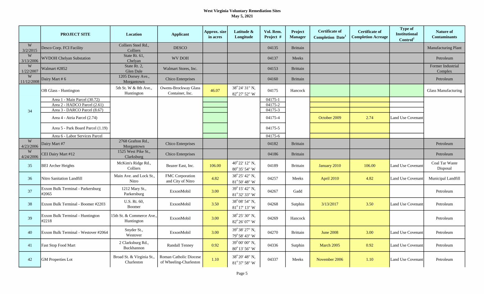
W
3/2/2015Desco Corp. FCI Facility
Colliers Steel Rd.,
ColliersDESCO 04135 Brittain Manufacturing Plant
W
3/13/2006WVDOH Chelyan Substation
State Rt. 61,
Chelyan WV DOH 04137 Meeks Petroleum
W
1/22/2007Walmart #2852
State Rt. 2,
Glen DaleWalmart Stores, Inc. 04153 Brittain
Former Industrial
Complex
W
11/12/2008Dairy Mart # 6
1205 Dorsey Ave.,
MorgantownChico Enterprises 04160 Brittain Petroleum
OB Glass - Huntington5th St. W & 8th Ave.,
Huntington
Owens-Brockway Glass
Container, Inc.46.07
38o 24' 31" N,
82o 27' 52" W
04175 Hancock Glass Manufacturing
Area 1 - Main Parcel (30.72) 04175-1
Area 2 - HADCO Parcel (2.61) 04175-2
Area 3 - DARCO Parcel (8.67) 04175-3
Area 4 - Atria Parcel (2.74) 04175-4 October 2009 2.74 Land Use Covenant
Area 5 - Park Board Parcel (1.19) 04175-5
Area 6 - Labor Services Parcel 04175-6
W
4/23/2006Dairy Mart #7
2768 Grafton Rd.,
MorgantownChico Enterprises 04182 Brittain Petroleum
W
4/24/2006CEI Dairy Mart #12
1525 West Pike St.,
ClarksburgChico Enterprises 04186 Brittain Petroleum
35 BEI Archer HeightsMcKim's Ridge Rd.,
ColliersBeazer East, Inc. 106.00
40o 22' 12" N,
80o 35' 54" W
04189 Brittain January 2010 106.00 Land Use CovenantCoal Tar Waste
Disposal
36 Nitro Sanitation Landfill Main Ave. and Lock St.,
Nitro
FMC Corporation
and City of Nitro4.82
38o 25' 42" N,
81o 50' 48" W
04257 Meeks April 2010 4.82 Land Use Covenant Municipal Landfill
37Exxon Bulk Terminal - Parkersburg
#2065
1212 Mary St.,
ParkersburgExxonMobil 3.00
39o 15' 42" N,
81o 32' 33" W
04267 Gadd Petroleum
38 Exxon Bulk Terminal - Boomer #2203U.S. Rt. 60,
BoomerExxonMobil 3.50
38o 08' 54" N,
81o 17' 13" W
04268 Sutphin 3/13/2017 3.50 Land Use Covenant Petroleum
39Exxon Bulk Terminal - Huntington
#2218
15th St. & Commerce Ave.,
HuntingtonExxonMobil 3.00
38o 25' 30" N,
82o 26' 07" W
04269 Hancock Petroleum
40 Exxon Bulk Terminal - Westover #2064Snyder St.,
WestoverExxonMobil 3.00
39o 38' 27" N,
79o 58' 43" W
04270 Brittain June 2008 3.00 Land Use Covenant Petroleum
41 Fast Stop Food Mart2 Clarksburg Rd.,
BuckhannonRandall Tenney 0.92
39o 00' 00" N,
80o 13' 56" W
04336 Sutphin March 2005 0.92 Land Use Covenant Petroleum
42 GM Properties LotBroad St. & Virginia St.,
Charleston
Roman Catholic Diocese
of Wheeling-Charleston1.10
38o 20' 48" N,
81o 37' 58" W
04337 Meeks November 2006 1.10 Land Use Covenant Petroleum
34
Page 5

West Virginia Voluntary Remediation Sites
May 5, 2021
PROJECT SITE Location ApplicantApprox. size
in acres
Latitude &
Longitude
Vol. Rem.
Project #
Project
Manager
Certificate of
Completion Date1
Certificate of
Completion Acreage
Type of
Institutional
Control2
Nature of
Contaminants
43 Dominion Hastings Extraction PlantState Rt. 20,
Hastings
Dominion Transmission,
Inc.5.08
39o 33' 03.14" N,
80o 40' 43.45" W
04339 Brittain September 2006 5.08 Land Use Covenant Petroleum
44 Chevron #163526129 West Lee St.,
CharlestonChevron 1.00
38o 21' 33" N,
81o 38' 30" W
04367
91-011-L20Meeks Petroleum
45 Sam Black Church ExxonU.S. Rt. 60,
Sam Black ChurchExxonMobil 0.90
37o 54' 24" N,
80o 38' 03" W
04373 Sutphin Petroleum
46 Daniels ConocoKayo Lane & US Hwy 19,
DanielsConoco Incorporated 0.19
37o 44' 26" N,
81o 06' 59" W
04374 Sutphin September 2009 0.19 Land Use Covenant Petroleum
47 Chevron #1635174132 MacCorkle Ave. SW,
South CharlestonChevron 0.50
38o 21' 27" N,
81o 43' 19" W
04376
91-076-L20Meeks Petroleum
48 Chevron #1635254227 MacCorkle Ave. SE,
South CharlestonChevron 0.50
38o 19' 26.4" N,
81o 35' 14.4" W
04377
88-019Meeks Land Use Covenant Petroleum
Huntfield DevelopmentRt. 340 & Huyett Rd.,
Charles TownHuntfield, LC
39o 16' 15" N,
77o 53' 30" W
04378 Brittain Former Orchard
Parcel 1 (78.40) 04378-1 February 2003 78.40 Land Use Covenant
Parcel 2A (12.91) 04378-2A August 2004 12.91 Land Use Covenant
Parcel 2AW - Bl. 12&13 (9.39)04378-2A
WestApril 2006 9.39 No Restrictions
Parcel 2B-1 (18.45) 04378-2B-1 August 2005 18.45 Land Use Covenant
Parcel 2B-2 (30.06) 04378-2B-2 December 2006 30.06 No Restrictions
Parcel 3A - Block 26 (3.80) 04378-3A(26) April 2006 3.80 No Restrictions
Parcel 3A - Block 27 (0.89) 04378-3A(27) July 2006 0.89 No Restrictions
Parcel 3A - Block 29 (3.88) 04378-3A(29) February 2012 3.88 No Restrictions
Recreation Center - Bl. 41 (6.16) 04378-RC July 2007 6.16 No Restrictions
Parcel 3A - less Bl. 26&27 (7.17) 04378-3A August 2007 7.17Land Use Covenant
(Block 25 only)
Unionridge Townhouses (4.36) 04378-UR June 2008 4.36 No Restrictions
Phase 5A (3.20) 04378-5A March 2009 3.20 No Restrictions
50 Chevron #122766108 Rt. 19,
HurricaneChevron 1.12
38o 26' 13" N,
82o 01' 00" W
04381 Hancock February 2014 1.12 Land Use Covenant Petroleum
51 Chevron #1227701000 East Main St.,
MiltonChevron 1.00
38o 26' 04" N,
82o 07' 37" W
04382
16-008Hancock Petroleum
178.6749
Page 6

West Virginia Voluntary Remediation Sites
May 5, 2021
PROJECT SITE Location ApplicantApprox. size
in acres
Latitude &
Longitude
Vol. Rem.
Project #
Project
Manager
Certificate of
Completion Date1
Certificate of
Completion Acreage
Type of
Institutional
Control2
Nature of
Contaminants
52 WVDOH Old D4 HQU.S. Rt. 19,
GoreWV DOH 0.17
39o 18' 15" N,
80o 21' 12" W
04399
93-257Brittain July 2004 0.17 Land Use Covenant Petroleum
W
8/27/2006Hartman's Franklin
502 Lee Dr.,
FranklinKenneth Hartman 04412 Brittain Petroleum & Solvents
53 Cremer Iron & Metal1800 Garfield Ave.,
ParkersburgRJ Recycling, LLC 10.00
39o 16' 41.21" N,
81o 33' 20.02" W
04421 Meeks Salvage Yard
54 Chemical Leaman - Scary CreekScary Creek Rd.,
Scott DepotChemical Leaman 3.00
38o 26' 10" N,
81o 54' 24" W
04434 Hancock Tanker Truck Cleaning
55 Bridge Road Exxon1400 Bridge Rd.,
CharlestonExxonMobil 0.50
38o 20' 2.66" N,
81o 38' 54.93" W
04475
87-009
96-059
Meeks Petroleum
56 ITAPCO Parkersburg1711 Grand Central Ave.,
Vienna
ITAPCO Parkersburg,
Inc.2.00
39o 18' 40" N,
80o 33' 07" W
04478 Hancock Salvage Yard
57 Kanawha Street Exxon #2-9507South Kanawha St.,
BeckleyExxonMobil 0.43
37o 46' 28" N,
81o 10' 46" W
04481 Sutphin August 2007 0.43 Land Use Covenant Petroleum
58 Exxon #2-9831516 Main St.,
SummersvilleExxonMobil 0.41
38o 16' 51" N,
80o 51' 10" W
04482 Sutphin June 2006 0.41 No Restrictions Petroleum
59 WV Terminals - Kenova23rd St. and Beech St.,
KenovaThe Ohio River Company 0.44
38o 24' 33" N,
82o 35' 24" W
04487 Hancock 10/22/2019 0.44 Land Use Covenant River Dock
60 PQS - Huntington Terminal #420218th St. & Virginia Ave.,
HuntingtonPennzoil-Quaker State 11.64
38o 24' 45" N,
82o 29' 13" W
04505 Hancock March 2006 11.64 Land Use Covenant Petroleum
61 PQS - Etowah Terminal #51171015 Barlow Dr.,
Charleston Pennzoil-Quaker State 4.55
38o 22' 09" N,
81o 36' 20" W
04506 Hancock December 2004 4.55 Land Use Covenant Petroleum
62 FMC - Spring Hill
S. Charleston Ordnance
Center, MacCorkle Ave.,
South Charleston
FMC Corporation 12.2238
o 21' 37.72" N,
81o 42' 17.09" W
04517 Meeks 11/7/2017 12.22 Land Use Covenant Chemical Plant
W
8/8/2003FHMC - Wheeling
242 Fulton St.,
WheelingHopkins Motor Company
04817
94-224Brittain Petroleum
W
2/3/2003CEI Dairy Mart #26
714 State St.,
FairmontChico Enterprises 04818 Brittain Petroleum
63 Greenbrier HotelU.S. Rt. 60,
White Sulfur SpringsCSX Hotels, Inc. 49.58
37o 46' 42" N,
80o 20' 17" W
04820 SutphinFacility & Grounds
Maintenance
Parcel A (24.10) 04820-A August 2003 24.10 Land Use Covenant
Parcel B (8.55) 04820-B March 2003 8.55 No Restrictions
Parcel C (16.93) 04820-C September 2003 16.93 Land Use Covenant
Page 7
West Virginia Voluntary Remediation Sites
May 5, 2021
PROJECT SITE Location ApplicantApprox. size
in acres
Latitude &
Longitude
Vol. Rem.
Project #
Project
Manager
Certificate of
Completion Date1
Certificate of
Completion Acreage
Type of
Institutional
Control2
Nature of
Contaminants
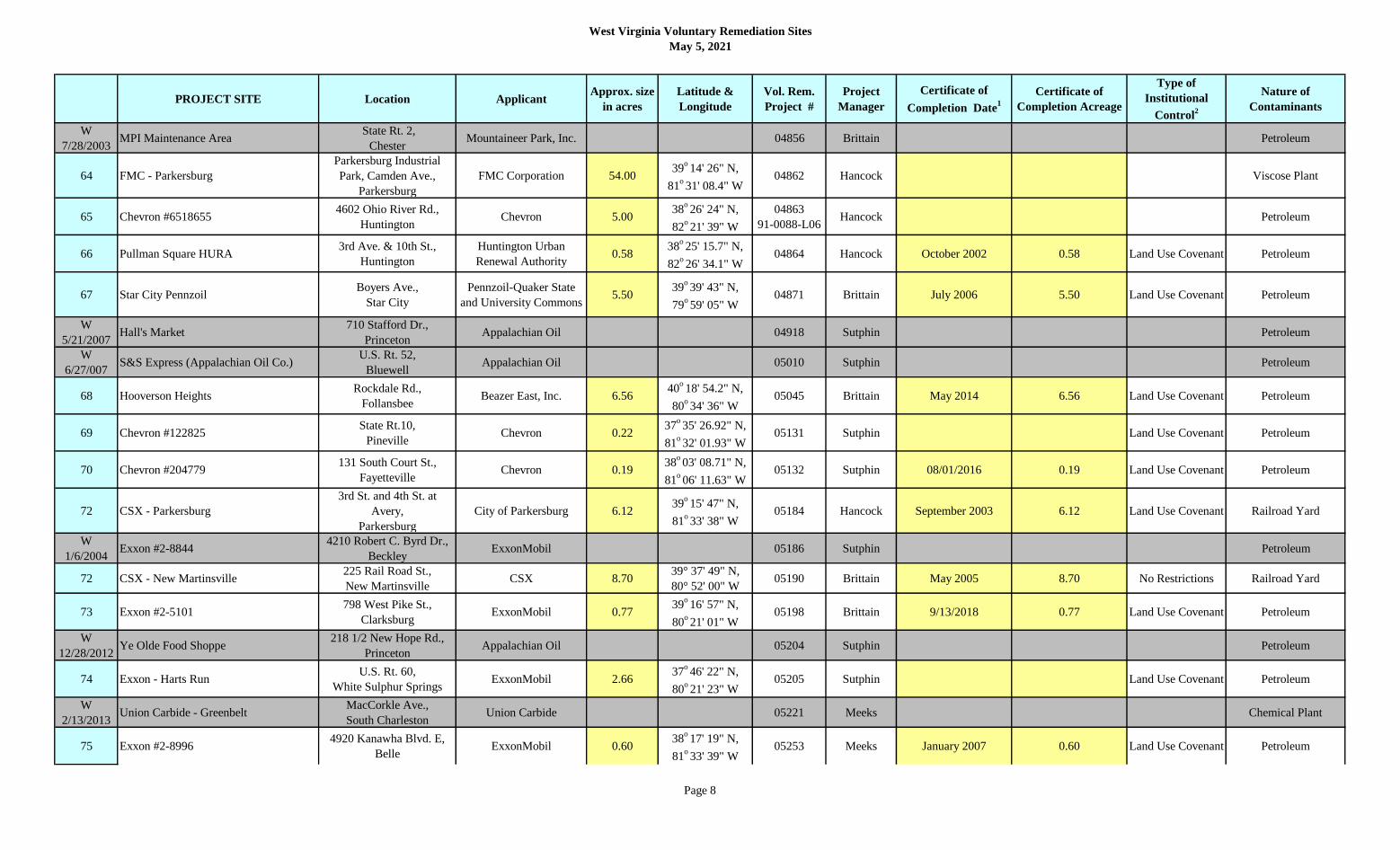
W
7/28/2003MPI Maintenance Area
State Rt. 2,
ChesterMountaineer Park, Inc. 04856 Brittain Petroleum
64 FMC - Parkersburg
Parkersburg Industrial
Park, Camden Ave.,
Parkersburg
FMC Corporation 54.0039
o 14' 26" N,
81o 31' 08.4" W
04862 Hancock Viscose Plant
65 Chevron #65186554602 Ohio River Rd.,
HuntingtonChevron 5.00
38o 26' 24" N,
82o 21' 39" W
04863
91-0088-L06Hancock Petroleum
66 Pullman Square HURA3rd Ave. & 10th St.,
Huntington
Huntington Urban
Renewal Authority0.58
38o 25' 15.7" N,
82o 26' 34.1" W
04864 Hancock October 2002 0.58 Land Use Covenant Petroleum
67 Star City PennzoilBoyers Ave.,
Star City
Pennzoil-Quaker State
and University Commons5.50
39o 39' 43" N,
79o 59' 05" W
04871 Brittain July 2006 5.50 Land Use Covenant Petroleum
W
5/21/2007Hall's Market
710 Stafford Dr.,
PrincetonAppalachian Oil 04918 Sutphin Petroleum
W
6/27/007S&S Express (Appalachian Oil Co.)
U.S. Rt. 52,
BluewellAppalachian Oil 05010 Sutphin Petroleum
68 Hooverson HeightsRockdale Rd.,
FollansbeeBeazer East, Inc. 6.56
40o 18' 54.2" N,
80o 34' 36" W
05045 Brittain May 2014 6.56 Land Use Covenant Petroleum
69 Chevron #122825State Rt.10,
PinevilleChevron 0.22
37o 35' 26.92" N,
81o 32' 01.93" W
05131 Sutphin Land Use Covenant Petroleum
70 Chevron #204779131 South Court St.,
FayettevilleChevron 0.19
38o 03' 08.71" N,
81o 06' 11.63" W
05132 Sutphin 08/01/2016 0.19 Land Use Covenant Petroleum
72 CSX - Parkersburg
3rd St. and 4th St. at
Avery,
Parkersburg
City of Parkersburg 6.1239
o 15' 47" N,
81o 33' 38" W
05184 Hancock September 2003 6.12 Land Use Covenant Railroad Yard
W
1/6/2004Exxon #2-8844
4210 Robert C. Byrd Dr.,
Beckley ExxonMobil 05186 Sutphin Petroleum
72 CSX - New Martinsville225 Rail Road St.,
New MartinsvilleCSX 8.70
39° 37' 49" N,
80° 52' 00" W05190 Brittain May 2005 8.70 No Restrictions Railroad Yard
73 Exxon #2-5101798 West Pike St.,
ClarksburgExxonMobil 0.77
39o 16' 57" N,
80o 21' 01" W
05198 Brittain 9/13/2018 0.77 Land Use Covenant Petroleum
W
12/28/2012Ye Olde Food Shoppe
218 1/2 New Hope Rd.,
PrincetonAppalachian Oil 05204 Sutphin Petroleum
74 Exxon - Harts RunU.S. Rt. 60,
White Sulphur SpringsExxonMobil 2.66
37o 46' 22" N,
80o 21' 23" W
05205 Sutphin Land Use Covenant Petroleum
W
2/13/2013Union Carbide - Greenbelt
MacCorkle Ave.,
South CharlestonUnion Carbide 05221 Meeks Chemical Plant
75 Exxon #2-89964920 Kanawha Blvd. E,
BelleExxonMobil 0.60
38o 17' 19" N,
81o 33' 39" W
05253 Meeks January 2007 0.60 Land Use Covenant Petroleum
Page 8

West Virginia Voluntary Remediation Sites
May 5, 2021
PROJECT SITE Location ApplicantApprox. size
in acres
Latitude &
Longitude
Vol. Rem.
Project #
Project
Manager
Certificate of
Completion Date1
Certificate of
Completion Acreage
Type of
Institutional
Control2
Nature of
Contaminants
76 WVDOH I-64 Maintenance HQI-64 & Hal Greer Blvd.,
HuntingtonWV DOH 2.00
38o 23' 31" N,
82o 24' 01"W
05260 Hancock 6/26/2020 2.00 Land Use Covenant Petroleum
Old Standard QuarryBloomery Rd.,
MillvilleOld Standard, LLC 289.43
39o 18' 04" N,
77o 46' 53" W
05295
04-053Brittain Limestone Quarry
Parcel A (286.33) 05295-A December 2003 286.33 No Restrictions
Parcel C (3.10) 05295-C August 2004 3.10 Land Use Covenant
W
2010 ABL Plant 2State Rt. 956,
Rocket CenterATK Tactical Systems 05358 Brittain
Munitions
Manufacturing
W
3/5/2015Paynes Ford
Short & Bower Rd.,
KearneysvilleJefferson Orchards, Inc. 05385 Brittain Orchard
78 Tenneco #139-46State Rt. 10,
StollingsEl Paso LLC 0.70
37o 50' 35" N,
81o 58' 00" W
05399
91-9961-L23Sutphin Petroleum
79 N&S - Bramwell 105-107 Main St.,
Bramwell
Norfolk Southern Railway
Company0.71
37o 19' 30.68" N,
81o 18' 46.38" W
05564 Sutphin February 2010 0.71Land Use Covenant
and City OrdinancePetroleum
80 John's Oil - Parkersburg431 Ann St.,
ParkersburgJohns Oil Company 1.33
39o 16' 03" N,
81o 33' 44" W
05687
99-147Hancock September 2008 1.33 Land Use Covenant Petroleum
81 Copenhaver Park - CSBHanna Dr.,
CharlestonCharleston Sanitary Board 20.40
38o 22' 43" N,
81o 40' 08" W
05761 MeeksWastewater Sludge
Disposal
Area 1 (19.43) 19.43
Area 2 (0.97) 0.97
82 OVIBDC - Benwood
Marshall County Industrial
Park, Phase II,
Benwood
OVIBDC 39.3339
o 59' 38.6" N,
80o 44' 14.9" W
05814 Brittain December 2003 39.33 Land Use Covenant Railroad Yard
83 Woda Construction4th-8th Streets,
Wheeling
D.J. Land Company, LLC
and Providence Greene,
LLC
6.0140
o 04' 35.5" N,
80o 43' 32" W
06307 Brittain July 2006 6.01 Land Use Covenant Railroad Yard
84 Petersburg Motors26 South Main St.,
Petersburg
Petersburg Motors and
Cookman Group, Inc.0.69
38o 59' 30" N,
79o 07' 27" W
06367
93-356Brittain December 2007 0.69 Land Use Covenant Petroleum
85 Avtex Landfill - Nitro
Par Industrial Park,
West 19th St.,
Nitro
FMC Corporation 14.0038
o 25' 52.99" N,
81o 51' 54.00" W
06422 Hancock Viscose Plant Landfill
86 AEP - 301 Virginia Street301 Virginia St.,
CharlestonAmerican Electric Power 1.06
38o 21' 08" N,
81o 38' 23" W
06430 Meeks October 2006 1.06 Land Use Covenant Former MGP
87 Dominion - Ben's RunState Rt. 2,
Ben's Run
Dominion Transmission,
Inc. 7.97
39o 28' 00" N,
81o 06' 03" W
06453 Brittain July 2006 7.97 Land Use Covenant Petroleum
September 2009 Land Use Covenant
77
Page 9

West Virginia Voluntary Remediation Sites
May 5, 2021
PROJECT SITE Location ApplicantApprox. size
in acres
Latitude &
Longitude
Vol. Rem.
Project #
Project
Manager
Certificate of
Completion Date1
Certificate of
Completion Acreage
Type of
Institutional
Control2
Nature of
Contaminants
88 Kanawha River Terminals - Ceredo
100 Main St. & River
Front,
Ceredo
Kanawha River
Terminals, Inc.2.80
38o 23' 55" N,
82o 33' 20" W
06611 Hancock August 2008 2.80 Land Use CovenantFormer Creosote Plant
& River Dock
89 Lowes - Wheeling
27th-29th Streets West of
Chapline St.,
Wheeling
GGP Wheeling 2003, LP 5.7940
o 03' 12" N,
80o 43' 32" W
06614 Brittain October 2004 5.79 Land Use CovenantVarious Residential
& Commercial Uses
W
2/23/2015Hypar Machine - Richwood
1 Commercial Ave.,
RichwoodHypar Machine Company 06620 Sutphin Chrome plating
90Ames Parkersburg - True Temper Plant
1
3801 Camden Ave.,
ParkersburgUSI Reality Corp. 25.18
39o 14' 49.31" N,
81o 31' 47.09" W
06786 Hancock November 2011 25.18 Land Use Covenant Manufacturing
91Ames Parkersburg - True Temper Plant
2
3301 Camden Ave.,
ParkersburgUSI Reality Corp. 24.65
39o 15' 04.73" N,
81o 32' 11.70" W
06787 Hancock November 2011 24.65 Land Use Covenant Manufacturing
92 Greenbrier - Old White Maint. FacilityU.S. Rt. 60,
White Sulfur SpringsCSX Hotels, Inc. 1.67
37o 47' 34.14" N,
80o 18' 44.57" W
06850 SutphinGolf Course
Maintenance
Parcel 6 06850-6 Land Use Covenant
Parcel 7 06850-7 Land Use Covenant
Parcel 8 06850-8 Land Use Covenant
93 Petersburg Tannery444 Virginia Ave.,
PetersburgHenry Moomau 6.40
38o 59' 41" N,
79o 06' 53" W
06870 Brittain April 2006 6.40 Land Use Covenant Former Tannery
94 UC/DOW - Kelly Field21st St.,
North CharlestonUnion Carbide 7.25
38o 22' 18" N,
81o 40' 32" W
06914 Meeks March 2016 7.25 Land Use Covenant
Former Chemical
Storage
& Disposal Area
95 McGuire Site - Chauncey7429 Jerry West Highway,
OmarMcGuire Family 1.46
37o 45' 56" N,
81o 59' 21" W
06918 Sutphin Land Use Covenant Petroleum
96 WVFS / Little Johns # 141137 U.S. Rt. 60,
Ceredo
WV Funeral Services,
LLC0.09
38o 23' 46.32" N,
82o 33' 14.16" W
06947 Hancock April 2016 0.09 Land Use Covenant Petroleum
97 Speedway - Eleanor #9764909 Roosevelt Blvd.,
Eleanor
Speedway SuperAmerica,
LLC0.71
38o 32' 20" N,
81o 56' 16" W
06949 Hancock February 2008 0.71 Land Use Covenant Petroleum
W
4/16/2015Black Diamond - West Huntington
2923 Park Ave.,
West HuntingtonSHBD, LP 06994 Hancock Metal Fabrication
W
8/4/2015Jefferson Orchards
365 Granny Smith Ln.,
Shenandoah JunctionJefferson Orchards, Inc. 06995 Gadd Former Orchard
98 Lowes at Princeton
420 Oakvale Rd.;
113 Blue Flash; and
1115 Ashland,
Princeton
Princetonlo, LLC 5.8137
o 21' 55" N,
81o 03' 00" W
06996 Sutphin Petroleum
August 2005 1.67
Page 10

West Virginia Voluntary Remediation Sites
May 5, 2021
PROJECT SITE Location ApplicantApprox. size
in acres
Latitude &
Longitude
Vol. Rem.
Project #
Project
Manager
Certificate of
Completion Date1
Certificate of
Completion Acreage
Type of
Institutional
Control2
Nature of
Contaminants
Blue Flash Tract (0.52) 06996-BF July 2005 0.52 Land Use Covenant
Neeley Tract (2.51) 06996-N 2.51 Land Use Covenant
Tract 1 & 2 (1.63) 06996-1&2 1.63 Land Use Covenant
Triangle & Ashland Tract (1.15) 06996-TA 1.15 Land Use Covenant
Oates PropertyDelmar Orchard Rd.,
Martinsburg
Martinsburg Ventures,
LLC50.70
39o 26' 55.39" N,
78o 00' 42.64" W
07028 Brittain Former Orchard
Parcel 1A (14.70) 07028-1A February 2007 14.70 Land Use Covenant
Parcel 1B (25.00) 07028-1B February 2007 25.00 Land Use Covenant
Parcel 1C (11.00) 07028-1C July 2007 11.00 No Restrictions
100 PENAC - Cullet PileHoult Rd.,
Fairmont
Philips Electronics,
North America Corp.2.70
39o 30' 10" N,
80o 07' 39" W
07089 Brittain November 2013 2.70 Land Use CovenantLight Bulb
Manufacturing
101 Rite Aid - Charleston #935406 W. Washington St.,
CharlestonRite Aid of WV, Inc. 1.20
38o 21' 45" N,
81o 38' 29" W
07094 Meeks 7/11/2017 1.20 Land Use CovenantFormer Service Station,
Repair & Paint Shop
W
4/17/2006Boyd's Crossing - Inwood
Rt. 11,
InwoodBoyd's Crossing, LLC 07252 Brittain Former Orchard
102 Richmond Cleaners1614 South Kanawha St.,
Beckley
Raleigh County
Commission on Aging1.20
37o 46' 13" N,
81o 10' 12" W
07259 Sutphin September 2005 1.20 Land Use CovenantFormer Laundry
& Dry Cleaners
103 Shell Refinery - St. MarysCreel St.,
St. MarysSOPUS Products 1.27
39o 23' 18" N,
81o 12' 35"W
07398 Brittain October 2008 1.27 Land Use Covenant Petroleum
104 Kidde Fire Fighting215 N. Mildred St,.
RansonKidde Fire Fighting, Inc. 8.17
39o 17' 53" N,
77o 51' 48" W
07434 GaddBrass and Aluminum
Foundry
Main Site (5.47) 07434 December 2009 5.47 Land Use Covenant
Parcel A (1.65) 07434-A February 2012 1.65 Land Use Covenant
Parcel B (1.05) 07434-B August 2012 1.05 Land Use Covenant
105 Kenova Terminal 101 23rd St.,
Kenova
Kenova Terminal
Company 16.50
38o 24' 32" N,
82o 35' 24" W
07461 HancockManufacturing, River
Dock, & Foundry
106 Frito-Lay - Huntington104 West 3rd Ave.,
HuntingtonFrito-Lay, Inc. 0.89
38o 25' 08" N,
82o 27' 39" W
07468 Hancock February 2007 0.89 Land Use Covenant Petroleum
W
3/2/2018Rice's Pennzoil
711 Riverview Dr.,
Belmont John's Oil Company
07469
99-025Brittain Petroleum
99
Page 11

West Virginia Voluntary Remediation Sites
May 5, 2021
PROJECT SITE Location ApplicantApprox. size
in acres
Latitude &
Longitude
Vol. Rem.
Project #
Project
Manager
Certificate of
Completion Date1
Certificate of
Completion Acreage
Type of
Institutional
Control2
Nature of
Contaminants
Fairfield Stadium 6.00
Main Site (4.85) March 9, 2007 4.85 Land Use Covenant
Parcel 1 (1.15) August 29, 2018 1.15 Land Use Covenant
108 Warren Distribution607 Baltimore Ave.,
Glen DaleWarren Distribution, Inc. 10.50
39o 57' 05" N,
80o 45' 29" W
07543 Gadd May 8, 2020 10.50 Land Use CovenantFormer Toy
Manufacturing
109 Sunoco - 2201 Chapline2201 Chapline St.,
WheelingSunoco, Inc. (R & M) 0.22
40o 03' 34" N,
80o 43' 22" W
07544 Brittain December 2007 0.22 No Restrictions Petroleum
110 Black's SunocoState Rt. 34,
Hurricane Jack & Lillian Black 0.50
38o 26' 14" N,
82o 01' 00" W
07559 Hancock April 2012 0.50 Land Use Covenant Petroleum
111 Morgantown Sunoco825 Don Knotts Blvd.,
MorgantownSunoco, Inc. (R & M) 0.32
39o 37' 34" N,
79o 57' 41" W
07572 Brittain July 2009 0.32 Land Use Covenant Petroleum
112 Sunoco - DaVinci's215 Highland Ave.,
WilliamstownSunoco, Inc. (R & M) 0.52
39o 24' 17" N,
81o 26' 53" W
07573 Hancock December 2012 0.52 Land Use Covenant Petroleum
W
3/15/2015McKee Crossing
State Rt. 9,
Martinsburg and
Kearneysville
F.O. Day Company 07576 Brittain Former Orchard
W
6/3/2013Butler Farm
State Rt. 24,
Ranson
Catoctin Development,
Inc. 07640 Brittain Former Orchard
W
4/3/2007McLaughlin Farm
3679 Gerrardstown Rd.,
Inwood
Catoctin Development,
Inc. 07641 Brittain Former Orchard
113 Vernon Close Property 313 Wilkes St.,
Berkeley Springs
Sunoco, Inc. (R & M) and
Evergreen Resources
Group, LLC
0.2239
o 37' 47" N,
78o 13' 38" W
07650
90-003Brittain 12/18/2019 0.22 Land Use Covenant Petroleum
114 Tri-State Terminal 237 23rd St.,
Kenova
Catlettsburg Refining,
LLC23.27
38o 24' 22" N,
82o 35' 23" W
07668 Hancock Petroleum
115 CSX - Berkeley Springs107 Williams St.,
Berkeley SpringsCSX 2.14
39o 37' 53.8" N,
78o 13' 26" W
07697 Brittain September 2012 2.14 Land Use Covenant
Railroad Depot,
Lumber & Wood Pulp
Handling Yard
116 Sabraton WVDOH1502 Earl Core Rd.,
MorgantownWV DOH 2.43
39o 37' 36.8" N,
79o 55' 37.2" W
07700 Brittain October 2007 2.43 Land Use CovenantCounty Highway
Maintenance Facility
117 Rich Oil #72301229 State Rt. 152,
WayneAshland, Inc. 0.80
38o 13' 08" N,
82o 26' 38" W
07811 Hancock May 2011 0.80 Land Use Covenant Petroleum
118 Ashland - Glen Dale201 South Park St.,
Glen DaleAshland, Inc. 0.96
39o 56' 56" N,
80o 45' 28" W
07813
96-170Brittain September 2012 0.96 Land Use Covenant Petroleum
HancockMunicipal Landfill
& Gravel Quarry Site
1275 15th St.,
HuntingtonMarshall University
38o 24' 41" N,
82o 25' 51" W
07491107
Page 12

West Virginia Voluntary Remediation Sites
May 5, 2021
PROJECT SITE Location ApplicantApprox. size
in acres
Latitude &
Longitude
Vol. Rem.
Project #
Project
Manager
Certificate of
Completion Date1
Certificate of
Completion Acreage
Type of
Institutional
Control2
Nature of
Contaminants
119 Dominion - WestonCounty Rt. 10,
Valley Chapel
Dominion Transmission,
Inc. 3.84
39o 06' 28.39" N,
80o 29' 42.05" W
07823
90-011-L21Meeks 8/29/2018 3.84 Land Use Covenant Petroleum
120 Rich Oil #39026063 Ohio River Rd.,
Huntington
Scott Hutchison
Enterprises1.08
38o 27' 31.03" N,
82o 18' 13.57" W
07825 Hancock January 2014 1.08 Land Use Covenant Petroleum
121 KT Properties - Kenova101 23rd St.,
KenovaAshland, Inc. 4.50
38o 24' 27.7" N,
82o 35' 20.55" W
07845 Hancock Petroleum
122 Texaco #3014013125 U.S. Rt. 60,
HuntingtonChevron 0.48
38o 24' 12.13" N,
82o 30' 11.02" W
07846 Hancock April 2014 0.48 Land Use Covenant Petroleum
123 Corhart RefractoryLiggett Ave.,
BuckhannonCorhart Refractories 0.34
39o 00' 04" N,
80o 14' 40" W
07848 Sutphin July 2011 0.34 Land Use CovenantCeramics & Plastic
Manufacturer
124 PENAC - Fairmont Terrace505 Hoult Rd.,
Fairmont
Philips Electronics,
North America Corp.46.00
39o 30' 14" N,
80o 07' 21" W
07857 Brittain Petroleum
W
1/16/2015Creo Middleway Plant
1 Grace St.,
MiddlewayEastman Kodak Company 07873 Brittain
Chemical Preparation
for Photographic Plates
W
3/17/2015Bryarly Manor Orchard
500 Corning Way & 5088
Tabler Station Rd.,
Inwood
Martinsburg Investors,
LLC 07981 Gadd Orchard
125 Dominion - Salem G & P YardRt. 1,
Salem
Dominion Transmission,
Inc. 5.38
39o 17' 13" N,
80o 32' 09" W
07994 Brittain March 2011 5.38 Land Use CovenantNatural Gasoline Plant
& Warehousing
126 Jim's Auto Service2834 Chapline St.,
Wheeling
Atlantic Richfield
Company0.50
40° 03' 8. 96" N,
80° 43' 32.15" W08036 Gadd June 2009 0.50 Land Use Covenant Petroleum
127 Larry McCoy Auto1302 C St.,
CeredoChevron 0.70
38o 23' 50.92" N,
82o 33' 7.51" W
08051
01-076Hancock Petroleum
128 McJunkin - Hansford Street1354 Hansford St.,
CharlestonMcJunkin Corporation 2.15
38o 20' 51" N,
81o 37' 11" W
08151 Meeks Metal Fabrication
129 Barboursville BrickyardPeyton St.,
BarboursvilleVillage of Barboursville 19.83
38o 24' 32.96" N,
82o 18' 19.77" W
08170 Hancock September 2010 19.83 Land Use CovenantBrick Manufacturing &
Petroleum
130 Dominion - Porto RicoCounty Rt. 19-11,
Porto Rico
Dominion Transmission,
Inc. 3.23
39o 10' 47" N,
80o 45' 45" W
08175 Brittain January 2012 3.23 Land Use Covenant Petroleum
131 Fairmont Sunoco726 East Park Ave.,
FairmontSunoco, Inc. 0.99
39o 28' 52" N,
80o 07' 28" W
08294
91-038-L25Brittain 10/17/2019 0.99 Land Use Covenant Petroleum
132 Mauser - Nitro100 Park Rd.,
NitroMauser Corporation 1.48
38o 26' 19" N,
81o 50' 15" W
08299 Meeks April 2014 1.48 No Restrictions
Plastic Drum
Manufacturing
& Testing
Page 13

West Virginia Voluntary Remediation Sites
May 5, 2021
PROJECT SITE Location ApplicantApprox. size
in acres
Latitude &
Longitude
Vol. Rem.
Project #
Project
Manager
Certificate of
Completion Date1
Certificate of
Completion Acreage
Type of
Institutional
Control2
Nature of
Contaminants
133 Adamston Glass
Adams Ave. & North 26th
St.,
Clarksburg
City of Clarksburg 5.6039
o 17' 33.80" N,
80o 21' 32.03" W
08442 Brittain November 2010 5.60 Land Use Covenant Glass Manufacturing
W
2/26/2009Court Street 76 Fayette
233 North Court St.,
Fayetteville
Union Oil Company of
California
08450
03-075Sutphin Petroleum
W
1/28/2019Turnpike Ford
2480 Fifth Ave.,
Huntington
Galigher Ford, Inc./DBA
Turnpike Ford of
Huntington
08451 Hancock Petroleum
134 Pure Oil - Parkersburg3330 Emerson Ave.,
Parkersburg
Union Oil Company of
California0.09
39o 17' 13.05" N,
81o 32' 04.12" W
08475 Hancock Petroleum
135 West Virginia MackOhio Ave. & N 4th St.,
ClarksburgCity of Clarksburg 11.83
39o 17' 11.4" N,
80o 20' 12.1" W
08502 Brittain February 2010 11.83 Land Use Covenant
Gas Company
Operations
& Salvage Yard
136 Winchester Cold StorageCold Storage Rd.,
Charles Town
Winchester Cold Storage
Company, Inc. 193.00
39o 16' 36" N,
77o 53' 05" W
08519 Gadd Pesticides/Petroleum
137 WVDOH Buckhannon
U.S. Rt. 33 & Brushy Fork
Rd.,
Buckhannon
WV DOH 3.5539
o 00' 01" N,
80o 15' 06" W
08520
98-124Sutphin February 2011 3.55 Land Use Covenant Petroleum
138 WVDOH Taylor Co. HQSycamore St.,
GraftonWV DOH 1.38
39o 20' 53" N,
80o 02' 24" W
08521 Brittain June 2013 1.38 Land Use Covenant Petroleum
139 Exxon #294973418 MacCorkle Ave.,
CharlestonExxonMobil 0.40
38° 18' 43" N,
81° 35' 56" W
08532
90-008-L20Meeks 6/27/2017 0.40
Land Uses
CovenantPetroleum
140 Speedway - Rainelle626 Kanawha Ave.,
Rainelle
Speedway SuperAmerica,
LLC0.96
37o 58' 02" N,
80o 46' 40" W
08534 Sutphin 3/25/2019 0.96 Land Use Covenant Petroleum
141 Quality Foundry - Clarksburg100 Stiles St.,
ClarksburgCity of Clarksburg 0.50
39o 16' 54.8" N,
80o 19' 31.8" W
08535 Brittain November 2009 0.50 Land Use Covenant Foundry/Metals
W
5/7/2008R&L Country Store
125 Odd Rd.,
GhentRoy and Linda Hall 08553 Sutphin Petroleum
142 Marathon Terminal - CharlestonStandard and MacCorkle
Ave., Charleston
Marathon Petroleum,
LLC6.21
38o 21' 04" N,
81o 38' 42" W
08600 Meeks 8/6/2019 6.53 Land Use Covenant Petroleum
143 Credit Union - Vienna1701 Grand Central Ave.,
ViennaWV Central Credit Union 0.92
39o 18' 54.64" N,
81o 33' 15.70" W
08603 Hancock August 2008 0.92 No Restrictions Petroleum
144 Unocal Bulk Terminal #306541Old U.S. Rt. 52,
WilliamsonChevron 2.01
37o 40' 51" N,
82o 17' 59" W
08654 Hancock March 2013 2.01 Land Use Covenant Petroleum
145 Chevron - Bradley4655 Robert C. Byrd Dr.,
BradleyChevron 0.64
37o 51' 56.16" N,
81o 11' 38.87" W
08664 Sutphin February 2014 0.64 Land Use Covenant Petroleum
Page 14

West Virginia Voluntary Remediation Sites
May 5, 2021
PROJECT SITE Location ApplicantApprox. size
in acres
Latitude &
Longitude
Vol. Rem.
Project #
Project
Manager
Certificate of
Completion Date1
Certificate of
Completion Acreage
Type of
Institutional
Control2
Nature of
Contaminants
146 Coopers Service Station2002 7th St.,
Parkersburg
Chevron Evironmental
Management Company
&
Texaco Inc.
0.3739
o 16' 05" N,
81o 31' 20" W
08792
97-034Hancock 3/1/2019 0.37 Land Use Covenant Petroleum
147 WVDOH HurricaneState Rt. 34 & Mill Rd.,
HurricaneWV DOH 2.09
38o 26' 06.91" N,
82o 00' 54.27" W
08816 Hancock June 2012 2.09 Land Use CovenantDOH Maintenance
& Storage Yard
148 CSX McColloch St.4000 McColloch St.,
WheelingCSX Real Property 4.50
40o 02' 21.3" N,
80o 43' 25.2" W
08817 Gadd Railroad Yard
149 Speedway #3972515 Pennsylvania Ave.,
Charleston
Speedway SuperAmerica,
LLC0.29
38o 21' 33" N,
81o 38' 30" W
08987 Meeks March 2016 0.29 Land Use Covenant Petroleum
Bias Service Station1050/1048 S Main St.,
Milton
Chevron
&
Union Oil Company of
California
3.2538° 26' 02" N,
82° 08' 02" W09029 Hancock Petroleum
Parcels 316.1 & 316.2 (0.50) 09029-1 January 2011 0.50 No Restrictions
Parcel 316
Parcel 317
151 WVDOH Pineville HQState Rt. 10 North,
PinevilleWV DOH 0.60
37° 38' 37.46" N,
81° 33' 26.77" W09041 Sutphin
DOH Maintenance
& Storage Yard
152 Chevron - Kanawha Blvd.1500 Kanawha Blvd. W,
CharlestonChevron 0.34
38° 21' 56" N,
81° 39' 53" W
09087
06-020
06-083
Meeks Petroleum
153 Browning LumberState Rd. 85 S,
Bald Knob
JPMorgan Chase Bank,
N.A.2.42
38° 21' 54.16" N,
81° 39' 50.21" W09109 Hancock February 2013 2.42 Land Use Covenant
Wood Treatment
Facility
154 Shell - BrooksvilleRt. 5,
Big Bend
Shell Oil Products
Company1.05
38° 57' 32.9" N,
81° 10' 21.4" W09113 Brittain Land Use Covenant Petroleum
155 Strait's Cleaners3719 MacCorkle Ave. SE,
Charleston
Daniel L. Strait, II and
Linda Strait0.32
38° 19' 38.87" N,
81° 35' 39.65" W09131 Meeks February 2011 0.32 Land Use Covenant
Former Laundry/
Dry Cleaners
156 Shell - Elm Run StationCounty Rt. 15,
Riverside
Pennzoil Quaker State
Company dba SOPUS
Products
13.9639° 10' 19.3" N,
81° 10' 34.1" W09132 Brittain 08/22/2016 13.96 Land Use Covenant Petroleum
157 Shell - Cain StationCounty Rt. 12,
Richardson
Shell Oil Products
Company0.29
38° 52' 49" N,
81° 14' 12" W09133 Hancock September 2013 0.29 Land Use Covenant Petroleum
158 WVHDF - Maier
57th St. & MacCorkle
Ave.,
Charleston
West Virginia Housing
Development Fund2.08
38° 18' 49.48" N,
81° 34' 05.05" W09135 Meeks 2/02/2018 2.08 Land Use Covenant Glass Manufacturing
159 Shell - Downs StationSunshine Rd.,
Rachel
Pennzoil Quaker State
Company dba SOPUS
Products
9.4439° 31' 11" N,
80° 18' 34" W09138 Brittain November 2014 9.44 Land Use Covenant Petroleum
160 Shell - Valley ForkState Rt. 36,
Valley Fork
Shell Oil Products
Company0.74
38° 32' 46" N,
81° 08' 09"W09140 Brittain Petroleum
150
Page 15
West Virginia Voluntary Remediation Sites
May 5, 2021
PROJECT SITE Location ApplicantApprox. size
in acres
Latitude &
Longitude
Vol. Rem.
Project #
Project
Manager
Certificate of
Completion Date1
Certificate of
Completion Acreage
Type of
Institutional
Control2
Nature of
Contaminants
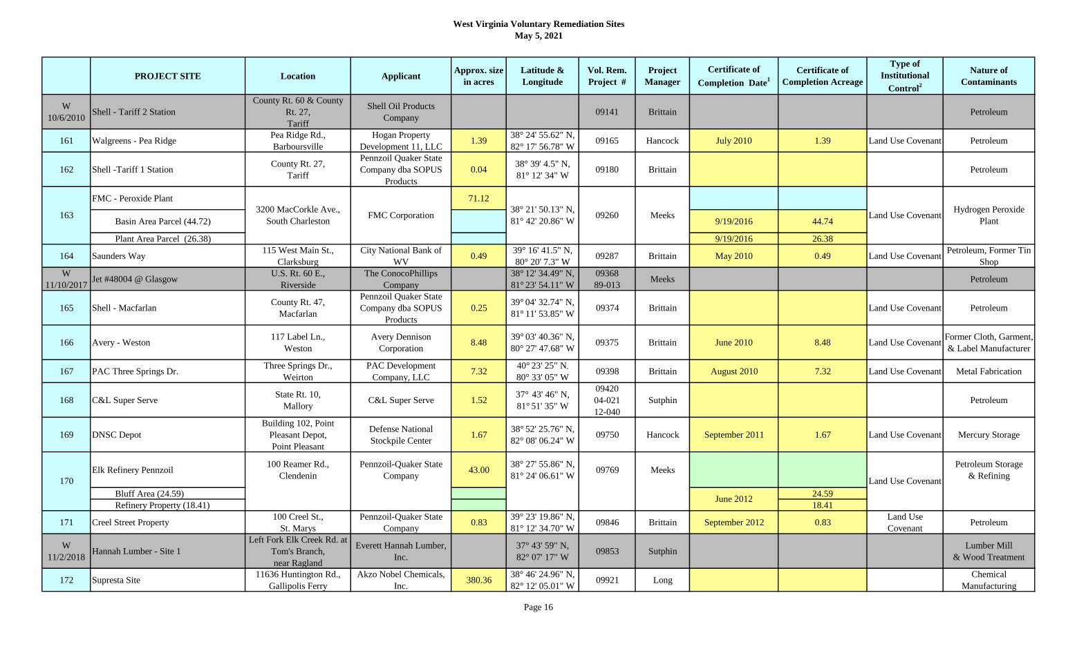
W
10/6/2010Shell - Tariff 2 Station
County Rt. 60 & County
Rt. 27,
Tariff
Shell Oil Products
Company09141 Brittain Petroleum
161 Walgreens - Pea RidgePea Ridge Rd.,
Barboursville
Hogan Property
Development 11, LLC1.39
38° 24' 55.62" N,
82° 17' 56.78" W09165 Hancock July 2010 1.39 Land Use Covenant Petroleum
162 Shell -Tariff 1 StationCounty Rt. 27,
Tariff
Pennzoil Quaker State
Company dba SOPUS
Products
0.0438° 39' 4.5" N,
81° 12' 34" W09180 Brittain Petroleum
FMC - Peroxide Plant 71.12
Basin Area Parcel (44.72) 9/19/2016 44.74
Plant Area Parcel (26.38) 9/19/2016 26.38
164 Saunders Way115 West Main St.,
Clarksburg
City National Bank of
WV0.49
39° 16' 41.5" N,
80° 20' 7.3" W09287 Brittain May 2010 0.49 Land Use Covenant
Petroleum, Former Tin
Shop
W
11/10/2017Jet #48004 @ Glasgow
U.S. Rt. 60 E.,
Riverside
The ConocoPhillips
Company
38° 12' 34.49" N,
81° 23' 54.11" W
09368
89-013Meeks Petroleum
165 Shell - Macfarlan County Rt. 47,
Macfarlan
Pennzoil Quaker State
Company dba SOPUS
Products
0.2539° 04' 32.74" N,
81° 11' 53.85" W09374 Brittain Land Use Covenant Petroleum
166 Avery - Weston117 Label Ln.,
Weston
Avery Dennison
Corporation8.48
39° 03' 40.36" N,
80° 27' 47.68" W09375 Brittain June 2010 8.48 Land Use Covenant
Former Cloth, Garment,
& Label Manufacturer
167 PAC Three Springs Dr.Three Springs Dr.,
Weirton
PAC Development
Company, LLC7.32
40° 23' 25" N,
80° 33' 05" W09398 Brittain August 2010 7.32 Land Use Covenant Metal Fabrication
168 C&L Super ServeState Rt. 10,
MalloryC&L Super Serve 1.52
37° 43' 46" N,
81° 51' 35" W
09420
04-021
12-040
Sutphin Petroleum
169 DNSC Depot
Building 102, Point
Pleasant Depot,
Point Pleasant
Defense National
Stockpile Center1.67
38° 52' 25.76" N,
82° 08' 06.24" W09750 Hancock September 2011 1.67 Land Use Covenant Mercury Storage
Elk Refinery Pennzoil100 Reamer Rd.,
Clendenin
Pennzoil-Quaker State
Company43.00
38° 27' 55.86" N,
81° 24' 06.61" W09769 Meeks
Petroleum Storage
& Refining
Bluff Area (24.59) 24.59
Refinery Property (18.41) 18.41
171 Creel Street Property100 Creel St.,
St. Marys
Pennzoil-Quaker State
Company0.83
39° 23' 19.86" N,
81° 12' 34.70" W09846 Brittain September 2012 0.83
Land Use
CovenantPetroleum
W
11/2/2018Hannah Lumber - Site 1
Left Fork Elk Creek Rd. at
Tom's Branch,
near Ragland
Everett Hannah Lumber,
Inc.
37° 43' 59" N,
82° 07' 17" W09853 Sutphin
Lumber Mill
& Wood Treatment
172 Supresta Site11636 Huntington Rd.,
Gallipolis Ferry
Akzo Nobel Chemicals,
Inc.380.36
38° 46' 24.96" N,
82° 12' 05.01" W09921 Long
Chemical
Manufacturing
092601633200 MacCorkle Ave.,
South Charleston
38° 21' 50.13" N,
81° 42' 20.86" WMeeks
Hydrogen Peroxide
PlantLand Use Covenant
June 2012
FMC Corporation
Land Use Covenant170
Page 16

West Virginia Voluntary Remediation Sites
May 5, 2021
PROJECT SITE Location ApplicantApprox. size
in acres
Latitude &
Longitude
Vol. Rem.
Project #
Project
Manager
Certificate of
Completion Date1
Certificate of
Completion Acreage
Type of
Institutional
Control2
Nature of
Contaminants
173 KCS-CSX Trestle100 Florida St.,
Charleston
Kanawha County Board
of Education0.98
38° 21' 51.5" N,
81° 39' 39.6" W 09989 Meeks Iron, Creosote
174 Former Quality GlassVan Voorhis Rd.,
Morgantown
Monongalia County
Commission2.71
39° 41' 00.89" N,
79° 57' 22.07" W09991 Brittain April 2012 2.71 Land Use Covenant Glass Manufacturing
175 St. Marys Refinery PL201 Barkwill St.,
St. Marys
Pennzoil-Quaker State
Company and St. Marys
Refining Company
0.4939° 23' 13.86" N,
81° 12' 22.36" W10011 Brittain August 2010 0.49 Land Use Covenant Petroleum
176 St. Marys Wood ProductState Rt. 2 South,
St.Marys
Yoak Rental Company,
LLC6.03
39° 22' 57.49" N,
81° 13' 28.49" W10112 Brittain September 2012 6.03 Land Use Covenant Former Lumber Mill
177 Roach Oil - John Street333 East John St.,
MartinsburgR.M. Roach & Sons, Inc. 0.67
39° 27' 14" N,
77° 57' 35" W10684 Brittain 6/14/2019 0.67 Land Use Covenant Petroleum
178 Hastings Tank FarmState Rt. 20,
Hastings
Dominion Transmission,
Inc. 5.00
39° 33' 10.68" N,
80° 40' 42.58" W10745 Meeks Natural Gasoline Plant
179 Sanitary Board Ash Pond300 Sunset Dr.,
Huntington
Huntington Sanitary
Board6.50
38° 23' 47.23" N,
82° 31' 26.29" W10856 Hancock February 2013 6.50
Land Use
Covenant
Municipal Sewage
Sludge
180 RTI - Piedmont Road4711 Piedmont Rd.,
Huntington
Rahall Transportation
Institute1.26
38° 23' 59.91" N,
82° 31' 42.55" W11013 Hancock December 2012 1.26
Land Use
Covenant
Chemical Storage/
Spill
181 Kermit LumberU.S. Rt. 52 & Anchor Rd.,
Greyeagle
Northfolk Southern
Railway Company6.70
37° 50' 56" N,
82° 25' 06" W11292 Sutphin
Wood Treatment
Facility
182 Fostoria Glass1200 First St.,
MoundsvilleCity of Moundsville 8.22
39° 55' 44" N,
80° 44' 24" W11418 Brittain June 2013 8.22
Land Use
CovenantGlass Manufacturing
183 Buckstone LLC - Belmont8598 S. Pleasants Hwy.,
Belmont
Affirm Oilfield Services,
LLC32.30
39° 20' 48" N,
81° 20' 08" W11442 Brittain 3/5/2019 32.30 Land Use Covenant River Dock
184 Chemical Leaman - InstituteRt. 25,
Institute
Chemical Leaman Tank
Lines, Inc.120.38
38° 23' 19" N,
81° 47' 45" W11680 Meeks 6/25/2020 120.38 Land Use Covenant Tanker Truck Cleaning
185 Blue Ridge CTC 13650 Apple Harvest Dr.,
Martinsburg
Blue Ridge Community &
Technical College43.00
39° 26' 04.09" N,
78° 00' 04.28" W11875 Gadd Land Use Covenant Former Orchard
186 N&S Williamson Railyard109 E. 4th Ave.,
Williamson
Northfolk Southern
Railway Company1.14
37° 39' 53" N,
82° 16' 11" W11886 Sutphin Railroad Transportation
Johns Manville Glass 33.00
River Side Parcels 10/29/2020 17.09 Land Use Covenant
Production Side Parcels
Glass Manufacturing1872905 3rd Ave.,
ViennaCity of Vienna
39° 19' 27" N,
81° 33' 09" W11966 Hancock
W
4/25/2019JL Clark Property
2201 6th Ave.,
CharlestonJ.L. Clark Corporation 11701 Meeks
Transportation
Equipment
Page 17

West Virginia Voluntary Remediation Sites
May 5, 2021
PROJECT SITE Location ApplicantApprox. size
in acres
Latitude &
Longitude
Vol. Rem.
Project #
Project
Manager
Certificate of
Completion Date1
Certificate of
Completion Acreage
Type of
Institutional
Control2
Nature of
Contaminants
188 WVDOH Tyler Co. HQ450 South State Rt. 2,
SistersvilleWV DOH 2.87
39° 32' 42.36" N,
81° 00' 59.04" W12028 Phillips
DOH Maintenance
& Storage Yard
189 Texaco Lubricants1500 Bluefield Ave.,
Bluefield
Pennzoil-Quaker State
Company0.80
37° 15' 44.64" N,
81° 14' 29.09" W12032 Sutphin April 2015 0.80
Land Use
Covenant
Former Lubricant
Distribution Facility
190 Shell - Wayne Six442 Murray Rd.,
New Cumberland
Pennzoil-Quaker State
Company0.74
40° 34' 11.18" N,
80° 35' 32.58" W12063 Brittain March 2013 0.74
Land Use
CovenantPetroleum
191 UC - HastingsOld Carbide Road,
Hastings
Eureka Hunter Pipeline,
LLC33.00
39° 32' 22" N,
80° 33' 17" W12183 Gadd
Gas Compression and
Separation Facility
192 Stella Jones Wood Treatment Facility3424 Parkersburg Rd.,
ReedyStella-Jones Corporation 31.00
38° 52' 7" N,
81° 24' 21" W12186 Meeks
Wood Treatment
Facility
193 GSBDC - Charleston321 Virginia St. W,
Charleston
Girl Scouts of Black
Diamond Council, Inc.1.08
38° 21' 37.08" N,
81° 38' 52.80" W12492 Meeks 1/13/2017 1.08
Land Use
CovenantPetroleum
TS&T Pottery 9.38
Area 1 - Upland Area 5/25/2018 8.48 Land Use Covenant
Area 2 -Steep River bank and Ohio
River Shoreline5/25/2018 0.90 Land Use Covenant
195 Shepherdstown LibraryRt. 45 & Rt. 480,
Shepherdstown
Economic Development
Authority for Jefferson
County and
Shepherdstown Public
Library
4.5039° 25' 48.27" N,
77° 49' 08.44" W12613 Gadd December 2014 4.50
Land Use
CovenantMunicipal Dump
196 KFC - Benwood207 Marshall St.,
BenwoodDBMFI, LLC 0.75
40° 01' 43" N,
80° 43' 44" W12666 Meeks 11/28/2018 0.75
Land Use
CovenantAsphalt and Petroleum
197 MB Bulk Plant - AnmooreRt. 58 W,
AnmooreNelson E. Matthews 7.94
39° 15' 8.9" N,
80° 17' 55.5" W12686 Brittain 4/17/2018 7.94 Land Use Covenant Petroleum
198 Dollar General - Weirton3662 Main St.,
WeirtonDG Strategic II, LLC 0.90
40° 23' 54.2" N,
80° 35' 28.0" W12742 Gadd
Land Use
CovenantPetroleum
199 Huntington Alloys3200 Riverside Dr.,
Huntington
Huntington Alloys
Corporation140.00
38° 24' 45.49" N,
82° 23' 01.65" W13061 Long Primary Metals
200 Kidde - City of Ranson215 N. Mildred St,.
RansonCity of Ranson 8.19
39° 17' 54.66" N,
77° 51' 44.66" W13079 Gadd
Brass and Aluminum
Foundry
Former Kidde Foundry (5.55)
Parcel A (1.59)
Parcel B (1.05)
201 American Chemical Services - Marmet11201 MacCorkle Ave.,
Marmet
American Chemical
Services2.20
38° 14' 05.64" N,
81° 33' 09.36" W13183 Meeks 3/12/2018 2.20 Land Use Covenant Chemical Storage
202State Rt. 20,
Webster SpringsTown of Addison
38° 28' 46.00" N,
81° 25' 03.00" W13204 Sutphin Railroad Depot
Webster Springs RR Depot 2.87
194
8th & Plutus Streets,
ChesterBrittain Pottery Manufacturing
08/01/2016 2.87Land Use
Covenant
Business Development
Corporation of the
Northern Panhandle
40° 37' 05.24" N,
80° 33' 32.59" W12512
Page 18

West Virginia Voluntary Remediation Sites
May 5, 2021
PROJECT SITE Location ApplicantApprox. size
in acres
Latitude &
Longitude
Vol. Rem.
Project #
Project
Manager
Certificate of
Completion Date1
Certificate of
Completion Acreage
Type of
Institutional
Control2
Nature of
Contaminants
203 Jones Compressor StationRt. 33 and 119,
Lockney
Dominion Transmission,
Inc.3.38
38° 51' 12.00" N,
80° 58' 00.00" W13234 Meeks Natural Gasoline
W
12/13/2016Follansbee Steel
1 State St.,
FollansbeeThe Louis Berkman Co. 13274 Gadd Steel Manufacturing
204 Morgan Co. BOE5595 Valley Rd.,
Berkeley Springs
Morgan Co.
Board of Education9.81
39° 33' 06.00" N,
78° 15' 59.00" W13554 Brittain 06/06/2017 9.81 No Restrictions
Former Orchard and
Auto Repair
La Brea Flats 292.97
Parcel B (15)
Parcel C (24.6) Land Use Covenant
206 Trimodal TerminalVeterans Dr.,
FollansbeeTrimodal Terminal, L.P. 79.41
40° 20' 08.78" N,
80° 36' 05.66" W13627 Long 3/21/2017 79.41
Land Use
CovenantPrimary Metals
207 Capital City Junk1200 Pennsylvania Ave.,
Charleston
West Virginia American
Water Company3.08
38° 21' 32.93" N,
81° 37' 47.60" W13674 Meeks
Former Junk Yard and
Salvage Yard
208 Tri-State Petroleum - New Martinsville98 South Main St.,
New Martinsville
Tri-State Petroleum
Corporation1.50
39° 38' 17.67" N,
80° 51' 59.42" W13681 Sutphin Petroleum
209 Supertane Gas Plant520 W. Congress St.,
Charles Town
City of Charles Town;
Evitts Run Conservancy;
The Perry Family
5.3139° 17' 10.17" N,
77° 51' 54.04" W13688 Brittain 7/22/2020 5.97 Land Use Covenant
Former Manufactured
Gas Plant
210 Billo's/LG Fac. #40802700 East Dupont Ave.
BelleQuincy Center 0.62
38° 12' 15.73" N,
81° 30' 15.55" W
13691
13-002Meeks Petroleum
211 McGinnis Inv. Corp.100-111 2nd Ave.,
Huntington
McGinnis Investment
Corp.4.10
38° 25' 41.67" N,
82° 25' 15.26" W13697 Hancock Pesticide Facility
W
6/16/2020ASCENT
9226 DuPont Rd.,
Washington
Appalachian Shale
Cracker Enterprise LLC13717 Brittain Plastics Production
212 Ohio River Terminals20 - 25th St.,
Huntington
Ohio River Terminals
Company, LLC22.60
38° 25' 54.52" N,
82° 24' 51.14" W13720 Hancock 9/5/2019 28.60 Land Use Covenant Coal Transfer Facility
213 GE Service Center - Charleston306 MacCorkle Ave. SE,
Charleston
General Electric
Company1.37
38° 20' 58.00" N,
81° 38' 36.00" W13733 Meeks Land Use Covenant
Repair/Service of
Motors, Tranformers
214 Freedom Industries1015 Barlow Dr.,
Charleston Freedom Industries 4.87
38° 22' 5.27" N,
81° 36' 23.53" W15017 Long 3/20/2018 4.87 Land Use Covenant
Coal Products
Manufacturing
Creo-CLP WV
308.87
Parcel 1 (60) 10/2/2017 60.00 No Restrictions
Parcel 2 (248.87) 6/15/2018 248.87 Land Use Covenant
Moundsville Plaza 28.99
Tract A 9/19/2018 18.45 Land Use Covenant
Archer Hill Rd.,
Follansbee6twelve Properties L.P.205
40° 20' 51.83" N,
80° 35' 54.78" W13626 Long
Chemical Preparation
for Photographic Plates
Coal Tar
215 150241 Grace St.,
Middleway
Commercial Liability
Partners WV, LLC
Brittain
216
12th St. and Lafayette
Ave.,
Moundsville
Brixmore GA
Moundsville, LLC
39° 18' 19" N,
77° 59' 49" W
15034
39° 18' 19" N,
77° 59' 49" W
Brittain Coal Storage and Zinc
Smelting
Page 19

West Virginia Voluntary Remediation Sites
May 5, 2021
PROJECT SITE Location ApplicantApprox. size
in acres
Latitude &
Longitude
Vol. Rem.
Project #
Project
Manager
Certificate of
Completion Date1
Certificate of
Completion Acreage
Type of
Institutional
Control2
Nature of
Contaminants
Tract B 9/19/2018 10.54 Land Use Covenant
217 P&G Tabler Station396 Development Dr.,
Inwood
The Proctor & Gamble
Manufacturing Co.458.12
39° 24' 53.37" N,
78° 0' 1.14" W15035 Brittain 5/23/2018 458.12 Land Use Covenant
Former Orchard
New Standard Quarry 92.00
Parcel A
Parcel B
Parcel C
Parcel D
Parcel E
Parcel F 12/21/2020 47.39 Land Use Covenant
W
1/26/2018Morgantown Standard
1301-1345 University
Ave.,
Morgantown
The Standard at
Morgantown, LLC15045 Brittain
Petroleum
Owens Illinois Fairmont 25.78
Parcel A 1/2/2018 21.61 Land Use Covenant
Parcel B 3/30/2018 4.18 Land Use Covenant
220 Barkers Creek Industrial Park651 Herndon Road,
Bud
Wyoming County
Economic Development
Authority
10.8537° 32' 54.76" N,
81° 24' 02.28" W16005 Sutphin 9/24/2019 10.85 Land Use Covenant
Wood Treatment
Facility
221 Pilot Store #2434304 First Ave.,
NitroPilot Travel Centers, LLC 4.67
38° 26' 36.92" N,
81° 49' 50.35" W16006 Meeks 2/21/2019 4.67 Land Use Covenant Petroleum
222 Town of Bath Rails to Trails
Washington St. and
Williams St.,
Berkeley Springs
Town of Bath 2.5839° 37' 55.12" N,
78° 13' 26.43" W16008 Gadd
Railroad Depot,
Lumber & Wood Pulp
Handling Yard
223 Camden Compressor Station6153 U.S. Hwy 33 W,
Camden
Dominion Transmission
Inc.16.50
39° 03' 34.83" N,
80° 35' 48.72" W16013 Meeks 1/4/2019 16.50 Land Use Covenant Natural Gas
224 Hypar Machine - Richwood1 Commercial Ave.,
RichwoodHypar Machine Company 0.28
38° 13' 25.56" N,
80° 32' 01.39" W16021 Sutphin Chrome Plating
225 CSXT Mt. Carbon Derailment188 Gina Drive,
Mt. CarbonCSX Transportation, Inc. 2.56
38° 08' 59.30" N,
81° 17' 34.61" W16023 Meeks Land Use Covenant Crude Oil
226 Haliburton elkview Field Camp5146 Elk River Rd.
Elkview
Halliburton Energy
Services, Inc3.60
38° 26' 56.79" N,
81° 27' 32.04" W
17007
89-053Hancock Petroleum
Beech Bottom Industrial Park
Parcel A10/18/2019 217.00 Land Use Covenant
Brittain607.56 40° 12' 54.77" N,
80° 39' 24.76" W
Business Development
Corporation of the
Northern Panhandle
8963 River Road,
Beech Bottom
17008
93-117
Peterolum, Coal
Minimg
227
219
1417 Morgantown Ave.,
Fairmont
Merit Development, Inc. 39° 28' 53.18" N,
80° 06' 52.67" W
15046 Brittain Glass Manufacturing
216
12th St. and Lafayette
Ave.,
Moundsville
Brixmore GA
Moundsville, LLC
39° 18' 19" N,
77° 59' 49" W
15034
596 Millville Rd.,
Harpers Ferry
Brittain Coal Storage and Zinc
Smelting
218 15044 Gadd
Limestone Quarry
39° 18' 4" N,
77° 46' 50" W
Standard Land Company,
LLC
Page 20

West Virginia Voluntary Remediation Sites
May 5, 2021
PROJECT SITE Location ApplicantApprox. size
in acres
Latitude &
Longitude
Vol. Rem.
Project #
Project
Manager
Certificate of
Completion Date1
Certificate of
Completion Acreage
Type of
Institutional
Control2
Nature of
Contaminants
Parcel B1/2/2020 384.00 Land Use Covenant
Parcel C1/2/2020 3.73 Land Use Covenant
Parcel D1/2/2020 2.83 Land Use Covenant
228 Halliburton Jane Lew Field Camp1628 Jackson Mill Road,
Jane lew
Halliburton Energy
Services, Inc5.80
39° 05' 6.00" N,
80° 27' 57.60" W17009 Hancock Petroleum and Acid
229 FMC Caldwell Property6 Smith Street
Nitro, WV
FMC Corporation
2929 Walnut Street
Philidelphia, PA 19104
0.4138° 24' 38.0" N,
81° 50' 46.0" W17011 Meeks 2/21/2017 0.41 N/A
Municiple and Non-
Municiple Waste
W
4/19/2017
Real Alloy-Former Alerix Bens Run
Recycling
4203 South State Route 2
Friendly, WV
Real Alloy Bens Run,
LLC17013 Brittain Aluminum Smelting
230 Dominion-Collins Compressor Station
6153 US HWY 33W
County Rt 11/4
(Left Fork Run Rd)
West Union, WV
Dominion Transmission
Inc.2.16
39° 15' 14.87" N,
80° 47' 28.07" W17014 Meeks 9/29/2020 2.16 Land Use Covenant Natural Gas
231 Dominion-Law Compressor StationTwo Lick Rd
Goodhope, WV
Dominion Transmission
Inc.16.50
39° 10' 05.88" N,
80° 28' 07.99" W17015 Meeks 3/6/2020 16.50 Land Use Covenant Natural Gas
232 Dominion-Orma Compressor StationCrooked Run Rd.
Orma, WV
Dominion Transmission
Inc.1.05 O 17016 Meeks Natural Gas
233 Hardee's Restaurant1506 Bigley Avenue
Charleston, WV
Albert T. Summers
Family Trust1.11
38° 21' 39.91" N,
81° 37' 21.15" W17019 Meeks 3/2/2018 1.11 Land Use Covenant Petroleum
234 Historic Grafton B&O Freight StationCorner of Latrobe and
Beech Street, Grafton WV
City of Grafton,
West Virginia0.29
39° 20' 27.00" N,
80° 01' 30.00" W17020 Brittain 1/2/2019 0.29 Land Use Covenant Railroad Yard
235 Mobley Plant14624 North Fork Road
Pine Grove, WV
MarkWest Liberty
Midstream & Resources,
LLC
200.0039° 33' 34.11" N,
80° 33' 24.37" W17022 Gadd Natural Gas
236 Cabinet Supply - Huntington1449 Washington Avenue
Huntington, WVCabinet Supply (CS), Inc.. 1.98
38° 24' 44.25" N,
82° 28' 51.88" W17023 Hancock
Petroleum, Lumber
Yard
237 North Branch Power Station2000 Energy Way
Gormania, WV
National Salvage and
Service Corporation288.00
39° 15' 37.00" N,
79° 19' 35.00" W17024 Gadd Power Plant
238 WVDOH District 1 HQ1340 Smith Street
Charleston, WVWV DOH 1.08
38° 20' 49.96" N,
81° 37' 14.11" W17025 Sutphin Petroleum
Former Follansbee Steel 16.24
Area 1 (3.73) 12/19/2018 3.73 Land Use Covenant
Area 2 (9.95) 9/8/2020 9.14 Land Use Covenant
Brittain607.56 40° 12' 54.77" N,
80° 39' 24.76" W
Business Development
Corporation of the
Northern Panhandle
8963 River Road,
Beech Bottom
17008
93-117
Peterolum, Coal
Minimg
Steel Manufacturing
227
2391 State Street
Follansbee, WV
Business Development
Corporation of the
Northern Panhandle40° 19' 20.96" N,
80° 35' 46.56" W17026 Gadd
Page 21

West Virginia Voluntary Remediation Sites
May 5, 2021
PROJECT SITE Location ApplicantApprox. size
in acres
Latitude &
Longitude
Vol. Rem.
Project #
Project
Manager
Certificate of
Completion Date1
Certificate of
Completion Acreage
Type of
Institutional
Control2
Nature of
Contaminants
Area 3 (2.75) 9/8/2020 2.33 Land Use Covenant
240 Pietro Fiorentini Site606 Park Drive
Weirton, WV
Business Development
Corporation of the
Northern Panhandle
26.4240° 22' 59.17" N,
80° 32' 58.94" W17029 Gadd 1/4/2019 26.42 Land Use Covenant Surface Coal Mining
241 DeWeese Property110 Minor Avenue
Nitro, WVFMC Corporation 0.33
38° 24' 45.00" N,
81° 50' 48.00" W17030 Meeks 8/17/2017 0.33 No Restrictions Landfill
242 Pennzoil Parkersburg19 1/2th and Keever Street
Parkersburg, WV
Urban Renewal Authority
of the City of Parkersburg5.37
39° 16' 58.79" N,
81° 33' 32.89" W15018 Hancock Petroleum
243 Jefferson Orchards365 Granny Smith Ln.,
Kearneysville, WV
Jefferson Orchards, Inc.75.00
39° 22' 34.87" N,
77° 52' 34.15" W17031 Gadd 8/24/2020 136.42 Land Use Covenant Former Orchard
244 Brooke Glass SiteYankee and 6th Streets
Wellsburg, WV
Business Development
Corporation of the
Northern Panhandle
1.5940° 16' 05.29" N,
80° 36' 43.26" W18002 Gadd 1/5/2021 1.59 Land Use Covenant Glass Manufacturing
245 Alker Tire21 East Main Street
Buckhannon, WV
Upshur County
Development Authority0.32
38° 59' 37.31" N,
80° 13' 45.81" W
18012
01-009Sutphin Petroleum
246Appalachian Tank Car Services - Hinton
Yard
494 Stokes Drive
Hinton, WV
Appalachian Tank Car
Services11.52
37° 39' 34.33" N,
80° 53' 23.25" W18003 Sutphin Railroad Yard
247 Huff Creek Compessor StationWV State Route 10,
Davin
Dominion Gathering and
Processing, Inc.0.92
37° 43' 51.53" N,
81° 47' 12.31" W18010 Meeks Natural Gas
248 Your Real Estate Solutions220 Minor Avenue,
NitroFMC Corporation 0.47
38° 24' 41.00" N,
81° 50' 48.00" W18013 Hancock 3/8/2018 0.47 No Restrictions Landfill
Heritage Holdings, LLC 19.10
VRP Parcel 1 (Main
Manufacturing Plant)
VRP Parcel 2 (Distribution
Center)8/10/2020 3.80 Land Use Covenant
VRP Parcel 3 (Fabrication Plant) 12/3/2019 1.70 Land Use Covenant
VRP Parcel 4 (Cabinet Plant) 12/3/2019 3.90 Land Use Covenant
250 Former Newell Porcelain Site500 Harrison St,
Newell 26050
Frank Six Enterprises,
LLC
&
Business Development
Corporation of the
Northern Panhandle
8.0640° 37' 13.86" N,
80° 36' 11.67" W18018 Gadd Pottery Manufacturing
251Upshur County Youth Camp Archery
Range
76 Youth Camp Road
Selbyville 26236
Upshur County
Commission0.66
38° 45' 37.13" N,
80° 14' 12.38" W18028 Sutphin 10/21/2020 0.66 Land Use Covenant
Charcoal & Wood
Alcohol Manufacturing
Meeks
249
2400 Charles St.,
Wellsburg
Heritage Holdings, LLC 40° 17' 12.00" N,
80° 36' 36.00" W
18016
Steel Manufacturing2391 State Street
Follansbee, WV
40° 19' 20.96" N,
80° 35' 46.56" W17026 Gadd
Manufacturing and
Handling
Page 22

West Virginia Voluntary Remediation Sites
May 5, 2021
PROJECT SITE Location ApplicantApprox. size
in acres
Latitude &
Longitude
Vol. Rem.
Project #
Project
Manager
Certificate of
Completion Date1
Certificate of
Completion Acreage
Type of
Institutional
Control2
Nature of
Contaminants
252 Superior Fibers, LLC456 South Robert Stone
Way, Reedsville, 26547
Superior Reedsville
Filtration, LLC12.84
39° 30' 22.19"N
78° 48' 21.97"W18029 Gadd
Metal
Fabrication/Foundry
253 Teletech100 Teletech Drive
Moundsville, 26041
Ohio Valley Industrial
Business Development
Corporation
15.2039° 54' 28.31"N
80° 44' 44.94"W18030 Gadd
Zinc
Smelting/Processing
254 Bryarly Manor Orchard West Parcel500 Corning Way
Martinsburg 25401
Horizon Martinsburg
868K Owner, LLC69.83
39° 23' 35.48"N
78° 1' 16.65"W19001 Gadd Orchard
255 Harrison County PowerPeeKay Road
Clarksburg, WV 26301
ESC Harrison County
Power, LLC16.50
39° 17' 11.44"N
80° 19' 16.85"W19002 Brittain Metals Recycling
256 CSXT Handley Rail YardRailroad Lane
Handley WV 25102CSX Transportation, Inc. 5.35
38° 11' 06.65"N
81° 21' 26.06"W19014 Sutphin Rail Yard
258 7-Eleven #35963 - West Union404 East Main Street
West Union, WV 264567-Eleven, Inc 0.39
39° 17' 36.80"N
80° 46' 17.03"W19015 Hancock Petroleum
258Grace Chapel Road Remediation and
Development
106 Grace Chapel Road
Kingwood, WV 26537
Preston County Economic
Development Authority14.40
39° 28' 36.35"N
79° 42' 29.44"W19019 Gadd 1/15/2021 14.40 No Restrictions
Bronze Metal
Fabrication
259 Advanced Graphite Materials, LLC2698 Philippi Pike
Anmoore, WV 26323
Clarksburg Real Estate
Holdings, LLC69.85
39° 15' 32.00"N
80° 17' 48.00"W19025 Long
Graphite
Manufacturing
260 Brake Supply Company
483 Turnpike Industrial
Rd.
Princeton, WV 24739
Brake Supply Company
Inc. 4.00
37° 22' 07.37"N
81° 02' 32.96"W19028 Sutphin
Hydraulic
Manufacturing
261 CSX-RidgeleyMiller Road
Carpendale, WV 26753CSX Transportation, Inc. 4.90
39° 38' 10.00"N
78° 47' 00.00"W19029 Gadd Rail Yard
262 Southern Tract-Elkins RailyardRail Road Ave
Elkins, WV 26241
Randolph County
Development Authorioty6.60
38° 55' 27.40"N
79° 51' 07.50"W19030 Phillips Rail Yard
263 CSX Railroad Parcel 9
East of North Mildred St &
North of East North St.
Charles Town, WV 25414
CSX Transportation, Inc. 0.1939° 17' 31.00"N
77° 51' 29.00"W20002 Gadd Rail Yard
264 Planet Fitness
MacCorkle Ave and 57th
Street, Charleston, WV
25304
MacCorkle and 57th
Street, LLC2.37
38° 18' 53.04"N
81° 34' 00.44"W20003 Meeks
Glass Manufacturing/
Warehouse
265 WVDOH Fayette County Headquarters1885 E. Main Street
Oak Hill, WV 25901
West Virginia Department
of Transportation,
Division of Highways
1.4737° 59' 45.00"N
81° 07' 58.00"W20005 Sutphin Petroleum
266 Thomas West RiverfrontThomas West Riverfront
Thomas, WV 26929
City of Thomas
PO Box 248
Thomas, WV 26292
8.0039° 09' 00.71"N
79° 29' 57.49"W20006 Gadd Rail Yard/Mining
267 CSXT Peach Creek Railyard
PO Box 100 (Allegheny
Avenue), Peach Creek WV
25601
CSX Transportation, Inc. 1.3237° 52' 35.91"N
81° 59' 12.66"W20008 Hancock Petroleum
Page 23

West Virginia Voluntary Remediation Sites
May 5, 2021
PROJECT SITE Location ApplicantApprox. size
in acres
Latitude &
Longitude
Vol. Rem.
Project #
Project
Manager
Certificate of
Completion Date1
Certificate of
Completion Acreage
Type of
Institutional
Control2
Nature of
Contaminants
268 Tanyard Station
US Hwy 60 and Big Ben
Bowen Hwy
Barboursville, WV 25504
Tanyard Station, LLC 7.2238° 24' 53.74"N
82° 17' 32.19"W20010 Hancock Rail Yard
269 Kanawha Manufacturing1520 Dixie Street
Charleston, WV 25311Kanawha Manufacturing 8.02
38° 20' 43.84"N
81° 37' 7.66"W20012 Meeks Metal Fabrication
270 Mingo Junction SteelworksMain Street
Weirton, WV 26062
Business Development
Corporation of the
Northern Panhandle
& Mingo Junction
Steelworks, LLC
281.8040° 24' 52.48"N
80° 35' 14.23"W20015 Brittain Steel Manufacturing
271 Clear Fork Rail TrailWhitesville and Clear
Creek
Raleigh County
Comission
116 1/2 Herber Street
Beckley, WV 25801
45.0037° 58' 11.11"N
81° 31' 14.23"W20016 Sutphin Railroad
272 Acme Wood Preserving200 Roseland Avenue
Princeton, WV 24740
Acme Wood Preserving,
Inc.
200 Roseland Avenue
Princeton, WV 24740
4.9837° 21' 42.88"N
81° 05' 04.98"W20017 Sutphin
Wood Treatment
Facility
273 Cheat River Rail Trail Manheim to Caddell 26425
Friends of the Cheat, Inc.
1343 North Preston
Highway, WV 26537
101.3039° 22' 14.20"N
79° 41' 54.12"W20018 Gadd Railroad
274 Carr China230 Newcome Avenue
Grafton, WV 26354
Save the Tygart
Watershed Association,
Inc.
PO Box 164, Grafton,
WV 26354
7.3939° 19' 10.45"N
80° 1' 33.78"W20019 Phillips Pottery Manufacturing
275 SABIC Innovative Plastics US LLC9226 DuPont Rd.
Washington, WV 26181
SABIC Innovative
Plastics US LLC
2500 CityWest Blvd,
Suite 100
Houston, TX 77042
172.4939° 15' 39.52"N
81° 40' 46.50"W21001 Long Plastic Manufacutring
276Black Diamond - Coalfields
Development
2923 Park Ave.,
Huntington
Coalfield Development
Corporation
PO Box 1133
Wayne, WV 25570
4.8938° 24' 00.50"N
82° 29' 54.60"W21009 Hancock
Metal fabrication and
Bulk Fuel Storage
277 ACF Industries2300 3rd Ave.
Huntington, WV 25714
Huntington Municipal
Development Authority36.60
38° 25' 35.890"N
82° 25' 04.53"W21013 Long Rail Car Manufacturing
278 Penn Wheeling Closure Property58 19th Street
Wheeling, WV 26003
City of Wheeling, West
Virginia2.70
40° 03' 40.40"N
80° 43' 02.60"W21019 Gadd
Petroleum, Chemical,
and Metal
Manufacturing
Page 24

West Virginia Voluntary Remediation Sites
May 5, 2021
PROJECT SITE Location ApplicantApprox. size
in acres
Latitude &
Longitude
Vol. Rem.
Project #
Project
Manager
Certificate of
Completion Date1
Certificate of
Completion Acreage
Type of
Institutional
Control2
Nature of
Contaminants
279 Lewisburg Wholesale Building107 Chestnut Street
Ronceverte, WV 24970
Ronceverte Development
Corporation0.57
37° 44' 51.21"N
80° 27' 55.15"W21020 Hancock
Retail, Automotive, and
Electronics
Manufacturing
280 Park Drive Redevelopment Property217 Park Drive
Weirton, WV 26062
Business Development
Corporation of Northern
Panhandle
69.6040° 23' 29.39"N
80° 33' 10.31"W21021 Gadd
Coal mining and Steel
Manufacturing
281 Filmont Property
3201 Kanawha Turnpike
South Charleston, WV
25303
Union Carbide
Corporation21.05
38° 21' 29.90"N
81° 42' 31.59"W21022 Meeks Landfill and Railyard
282 Hinton Ice House508 Commercial Avenue
Hinton, WV 25951
New River Gorge
Regional Development
Authority
0.4437.676908
-80.88788821037 Hancock
Coal and Equipment
Storage
283 Novelis-Buckhannon2 Moore Avenue
Buckhannon, WV 26201
Aleris Rolled Products,
Inc.14.75
38.975881
-80.2244521038 Phillips
Printing and Aluminum
Production
# of Projects - 283 6,689.22
# of COCs - 227 3,704.41
1 - If no "Certificate of Completion" date is noted, then activities to assess and remediate the site are either planned or are underway.
2 - If no "Institutional Control" is specified, then the use designation is under evaluation at this time.
3- If a site is highlighted gray, it has withdrawn from the Voluntary Remediation Program.
Total COC Acres -
Total Project Acres -
Page 25