Material Sources Which Have Previously Completed the ADOT ...
39
Page 1 Of 39 Information provided to requestor was developed by the Arizona Department of Transportation. The information was developed for internal use. The Department accepts no responsibility for any conditions encountered which may be at variance from information herein. 08/04/2021 Material Sources Which Have Previously Completed the ADOT Environmental Analysis Process The following material sources have previously completed the ADOT Environmental Analysis process including cultural consultation. This list indicates only completion of an initial environmental analysis. An updated Environmental Analysis must be submitted to the Resident Engineer of each project for approval. The ADOT Engineer will determine whether these and other provisions in the ADOT Specifications have been met for final approval of use of the site. Apache / AZ CM2040 Cheto Mine MEADOW VALLEY CONTRACTORS, INC. 12/17/2003 T21N, R29E, Sec. 26. From US 191 @ approx MP 368.1, go west on Navajo Blvd to E Butte, then north to Clay Mine Rd, take Clay Mine Rd approx. 5.25 miles to site on right. Apache / AZ CM2350 Coyote Creek Pit JOHNSON CATTLE CO. JOHNSON CATTLE CO. 06/25/2014 T10N, R29E, Sec. 6. US 191 @ MP 386.3 go east on county road 4162 at "Springerville Generating Station" sign, approximately 3.2 miles to gate on right @ corral area. Apache / AZ CM2282 Hall Pit PERKINS CINDERS, INC GREY MOUNTAIN CONSTRUCTION LLC 09/30/2015 T08N, R29E, Sec. 12, N1/2. From US 60 in Springerville, travel south on US 191/180 for approx. 2 miles, turn left on Picnic Creek Rd, travel 0.8 mile and turn left to pit. Apache / AZ CM2144 Brier Borrow Source FISHER SAND & GRAVEL 02/14/2006 T20N, R28E, Sec. 25, NE1/4. From Sanders, take US 191 approx. 7 miles south to MP 361.1; site is immediately east of US 191. Apache / AZ CM0297 Anderson Zuni Ranch Materials ALBERT S. & SHIRLEY H. ANDERSON L.L.C. 07/09/1999 T15N, R29E, Sec. 3. On US 191, go approx.18 miles north of St. Johns to MP 333.7, then approx. 1/2 mile west of US 191. Apache / AZ CM2331 Brier Borrow Source #2 GREY MOUNTAIN CONSTRUCTION LLC 04/04/2013 T21N, R28E, Sec. 23, NE1/4. Site is west of US 191 approximately 2500 south of I-40 Exit 339. Take US 191 south to Williams Dr., then right on Upper Rim Dr. 400 ft. Apache / AZ CM2330 Brier Borrow Source #1 GREY MOUNTAIN CONSTRUCTION LLC 04/04/2013 T21N, R28E, Sec. 14,23. Site is west of US 191 approximately 900 south of I-40 Exit 339. Apache / AZ CM2361 Ganado Borrow Source NAVAJO NATION - MINERALS DEPARTMENT FNF CONSTRUCTION, INC. 09/29/2016 T27N, R26E, Sec. 13, SE1/4. From SR 264 & IR 27 Junction go north 2 miles, go west to site about 1785 ft. County/ State Tracking Number Source Name Owner Last Operator EA Effective Location Contact: Ed Green - Phone: (602) 920-3882 - E-mail: [email protected] Current as of: For inquiries, to find out the specifics of special condition(s), or to report errors in this information, please contact the person shown above. This is not a complete list; please contact the person indicated above for additional information.
Transcript of Material Sources Which Have Previously Completed the ADOT ...

Page 1 Of 39
Information provided to requestor was developed by the Arizona Department of Transportation. The information was developed for internal use. The Department accepts no responsibility for any conditions encountered which may be at variance from information herein.
08/04/2021Material Sources Which Have Previously Completed the ADOT Environmental Analysis Process
The following material sources have previously completed the ADOT Environmental Analysis process including cultural consultation. This list indicates only completion of an initial environmental analysis. An updated Environmental Analysis must be submitted to the Resident Engineer of
each project for approval. The ADOT Engineer will determine whether these and other provisions in the ADOT Specifications have been met for final approval of use of the site.
Apache/ AZ
CM2040 Cheto Mine MEADOW VALLEY CONTRACTORS, INC.
12/17/2003 T21N, R29E, Sec. 26. From US 191 @ approx MP 368.1, go west on Navajo Blvd to E Butte, then north to Clay Mine Rd, take Clay Mine Rd approx. 5.25 miles to site on right.
Apache/ AZ
CM2350 Coyote Creek Pit
JOHNSON CATTLE CO.
JOHNSON CATTLE CO.
06/25/2014 T10N, R29E, Sec. 6. US 191 @ MP 386.3 go east on county road 4162 at "Springerville Generating Station" sign, approximately 3.2 miles to gate on right @ corral area.
Apache/ AZ
CM2282 Hall Pit PERKINS CINDERS, INC
GREY MOUNTAIN CONSTRUCTION LLC
09/30/2015 T08N, R29E, Sec. 12, N1/2. From US 60 in Springerville, travel south on US 191/180 for approx. 2 miles, turn left on Picnic Creek Rd, travel 0.8 mile and turn left to pit.
Apache/ AZ
CM2144 Brier Borrow Source
FISHER SAND & GRAVEL
02/14/2006 T20N, R28E, Sec. 25, NE1/4. From Sanders, take US 191 approx. 7 miles south to MP 361.1; site is immediately east of US 191.
Apache/ AZ
CM0297 Anderson Zuni Ranch Materials
ALBERT S. & SHIRLEY H. ANDERSON L.L.C.
07/09/1999 T15N, R29E, Sec. 3. On US 191, go approx.18 miles north of St. Johns to MP 333.7, then approx. 1/2 mile west of US 191.
Apache/ AZ
CM2331 Brier Borrow Source #2
GREY MOUNTAIN CONSTRUCTION LLC
04/04/2013 T21N, R28E, Sec. 23, NE1/4. Site is west of US 191 approximately 2500 south of I-40 Exit 339. Take US 191 south to Williams Dr., then right on Upper Rim Dr. 400 ft.
Apache/ AZ
CM2330 Brier Borrow Source #1
GREY MOUNTAIN CONSTRUCTION LLC
04/04/2013 T21N, R28E, Sec. 14,23. Site is west of US 191 approximately 900 south of I-40 Exit 339.
Apache/ AZ
CM2361 Ganado Borrow Source
NAVAJO NATION - MINERALS DEPARTMENT
FNF CONSTRUCTION, INC.
09/29/2016 T27N, R26E, Sec. 13, SE1/4. From SR 264 & IR 27 Junction go north 2 miles, go west to site about 1785 ft.
County/ State
Tracking Number
Source Name Owner Last Operator EA Effective Location
Contact: Ed Green - Phone: (602) 920-3882 - E-mail: [email protected] Current as of:
For inquiries, to find out the specifics of special condition(s), or to report errors in this information, please contact the person shown above. This is not a complete list; please contact the person indicated above for additional information.
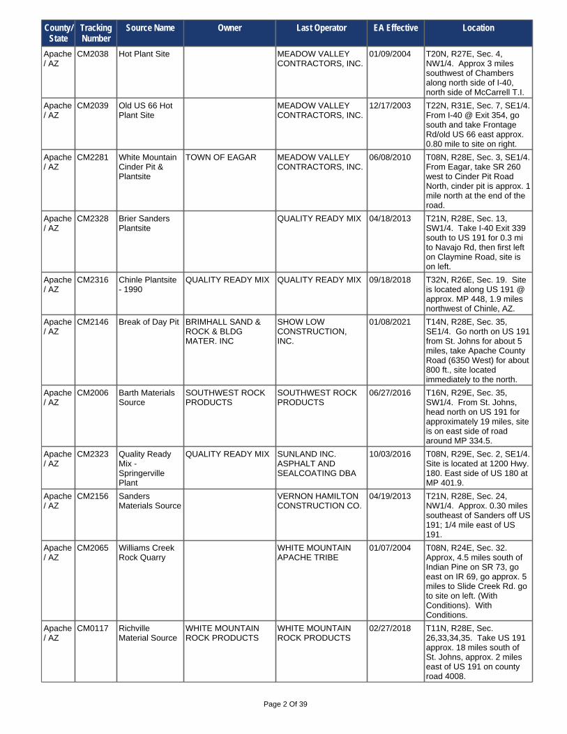
Page 2 Of 39
Apache/ AZ
CM2146 Break of Day Pit BRIMHALL SAND & ROCK & BLDG MATER. INC
SHOW LOW CONSTRUCTION, INC.
01/08/2021 T14N, R28E, Sec. 35, SE1/4. Go north on US 191 from St. Johns for about 5 miles, take Apache County Road (6350 West) for about 800 ft., site located immediately to the north.
Apache/ AZ
CM2316 Chinle Plantsite - 1990
QUALITY READY MIX QUALITY READY MIX 09/18/2018 T32N, R26E, Sec. 19. Site is located along US 191 @ approx. MP 448, 1.9 miles northwest of Chinle, AZ.
Apache/ AZ
CM2006 Barth Materials Source
SOUTHWEST ROCK PRODUCTS
SOUTHWEST ROCK PRODUCTS
06/27/2016 T16N, R29E, Sec. 35, SW1/4. From St. Johns, head north on US 191 for approximately 19 miles, site is on east side of road around MP 334.5.
Apache/ AZ
CM2156 Sanders Materials Source
VERNON HAMILTON CONSTRUCTION CO.
04/19/2013 T21N, R28E, Sec. 24, NW1/4. Approx. 0.30 miles southeast of Sanders off US 191; 1/4 mile east of US 191.
Apache/ AZ
CM2323 Quality Ready Mix - Springerville Plant
QUALITY READY MIX SUNLAND INC. ASPHALT AND SEALCOATING DBA
10/03/2016 T08N, R29E, Sec. 2, SE1/4. Site is located at 1200 Hwy. 180. East side of US 180 at MP 401.9.
Apache/ AZ
CM2038 Hot Plant Site MEADOW VALLEY CONTRACTORS, INC.
01/09/2004 T20N, R27E, Sec. 4, NW1/4. Approx 3 miles southwest of Chambers along north side of I-40, north side of McCarrell T.I.
Apache/ AZ
CM2039 Old US 66 Hot Plant Site
MEADOW VALLEY CONTRACTORS, INC.
12/17/2003 T22N, R31E, Sec. 7, SE1/4. From I-40 @ Exit 354, go south and take Frontage Rd/old US 66 east approx. 0.80 mile to site on right.
Apache/ AZ
CM2328 Brier Sanders Plantsite
QUALITY READY MIX 04/18/2013 T21N, R28E, Sec. 13, SW1/4. Take I-40 Exit 339 south to US 191 for 0.3 mi to Navajo Rd, then first left on Claymine Road, site is on left.
Apache/ AZ
CM2281 White Mountain Cinder Pit & Plantsite
TOWN OF EAGAR MEADOW VALLEY CONTRACTORS, INC.
06/08/2010 T08N, R28E, Sec. 3, SE1/4. From Eagar, take SR 260 west to Cinder Pit Road North, cinder pit is approx. 1 mile north at the end of the road.
Apache/ AZ
CM0117 Richville Material Source
WHITE MOUNTAIN ROCK PRODUCTS
WHITE MOUNTAIN ROCK PRODUCTS
02/27/2018 T11N, R28E, Sec. 26,33,34,35. Take US 191 approx. 18 miles south of St. Johns, approx. 2 miles east of US 191 on county road 4008.
Apache/ AZ
CM2065 Williams Creek Rock Quarry
WHITE MOUNTAIN APACHE TRIBE
01/07/2004 T08N, R24E, Sec. 32. Approx, 4.5 miles south of Indian Pine on SR 73, go east on IR 69, go approx. 5 miles to Slide Creek Rd. go to site on left. (With Conditions). With Conditions.
County/ State
Tracking Number
Source Name Owner Last Operator EA Effective Location

Page 3 Of 39
Cochise/ AZ
CM2195 Mallet Ranch Pit 10 X RANCH 07/18/2007 T20S, R31E, Sec. 13,14. Located 40 miles east of Douglas on SR 80, approx. MP 406.
Cochise/ AZ
CM2164 Diamond Bar Materials
DIAMOND BAR MATERIALS
02/20/2006 T19S, R26E, Sec. 21. Site is located along the west side of US 191 just north of W Cortland Rd @ MP 30.1.
Cochise/ AZ
CM2360 Thomas Material Source
FISHER SAND & GRAVEL
FISHER SAND & GRAVEL
04/12/2018 T22S, R23E, Sec. 7,18. From Bisbee take SR 80 to SR 90. Go W. 1.75 mi. to Sharp Shooter Rd. Take Sharp Shooter Rd. .25 mi. S. to mine access rd.Then W. & S. 0.5 mi. to site.
Cochise/ AZ
CM2143 Sierra Vista Material Source
BLM Community Pit 04/07/2005 T22S, R22E, Sec. 23, NW1/4. 2.5 miles south of milepost 332 off of SR 90.
California
CM2000 Crawford Mine CRAWFORD ASSOCIATES
07/21/2003 T05S, R23E, Sec. 27. Site is approx. 6.25 miles north of I-10 on California US 95, near Blythe.
Cochise/ AZ
CM2294 Banning Creek 05/13/2011 T22S, R23E, Sec. 21, NE1/4. From Bisbee go approx. 4 mi. on US 80 to MP 334, go north on N Pinteck Ranch Rd approx. 3/8 mi.
Cochise/ AZ
CM2346 Commonwealth Material Source
COMMONWEALTH SILVER & GOLD CORPORATION
FISHER SAND & GRAVEL CO.
02/14/2014 T18S, R25E, Sec. 4,5. Take I-10 west to Exit 331, go south on US 191 approx. 20 mi to MP 47, go south on Ghost Town Trail for 1.35 mi to site on left.
Cochise/ AZ
CM2147 Harris Borrow Site
GRANITE CONSTRUCTION, INC.
01/03/2006 T13S, R24E, Sec. 23, NW1/4. From I-10 @ Exit 340 in Willcox, proceed north on Fort Grant Rd to Packing Plant Rd, go east to site on right.
Cochise/ AZ
CM2128 Johnson Camp Mine
TEXAS CANYON ROCK AND SAND
FISHER SAND AND GRAVEL CO.
07/24/2014 T15S, R22E, Sec. 25,26,36. From I-10 Exit 322 (N Johnson Rd) take E Adams Ranch Rd north 0.3 mi. to Johnson Rd on right, go for 1 mile to the site.
Cochise/ AZ
CM0380 CEMEX - Sierra Vista Plant
CEMEX CONSTRUCTION MATERIALS SOUTH LLC
FNF INC 01/27/2021 T22S, R21E, Sec. 17, S1/2. From Sierra Vista, take SR 92 south to Buffalo Soldier Trail (MP 324.2), turn leftt and travel 1.0 mile to plant at 5231 E. Buffalo Soldier Trail.
Cochise/ AZ
CM2169 Babocomari Ranch Material Source
GRANITE CONSTRUCTION COMPANY
GRANITE CONSTRUCTION COMPANY
12/16/2020 T20S, R20E, Sec. 31,32. From I-10 Exit 302, go south on SR 90 to approx. MP 311.8, then east on E Railroad Dr to site.
County/ State
Tracking Number
Source Name Owner Last Operator EA Effective Location

Page 4 Of 39
Cochise/ AZ
CM2314 Klump Concrete Plant
KLUMP MATERIALS LLC
J. BANICKI CONSTRUCTION, INC.
04/02/2021 T14S, R25E, Sec. 6, SW1/4. From the I-10B (Business Loop) in Wilcox, turn south into the plantsite driveway at approx. MP 339.25.
Cochise/ AZ
CM2113 Klump Pit KLUMP RANCHES LLC
J. BANICKI CONSTRUCTION, INC.
04/02/2021 T13S, R27E, Sec. 7. From I-10, take Exit 355 south, east on frontage road for 1.1 miles, south on Gold Gulch Rd. for 2.5 miles, east on access road for 0.25 mile to site.
Cochise/ AZ
CM2175 Ocotillo Plant HUACHUCA CONCRETE, INC.
11/07/2006 T16S, R20E, Sec. 17, W1/2. From I-10 @ Exit 304 take N Ocotillo Road north approx. 6 miles to site on left, just past N Park Ranch Rd.
Coconino/ AZ
CM0104 Plant #336, McCormick Pit
CEMEX CONSTRUCTION MATERIALS SOUTH, LLC
CEMEX CONSTRUCTION MATERIALS SOUTH, LLC
06/12/2020 T23N, R08E, Sec. 9. At Robinson Crater - haul road begins approx. 1 mile east of SR 89 on Sunset Crater Rd.
Cochise/ AZ
CM2149 Kuhn Sand Site GRANITE CONSTRUCTION, INC.
01/03/2006 T14S, R24E, Sec. 10, NW1/4. From I-10 @ Exit 336 go north on Taylor Rd to W Park Pl, go west to S Collins Ln, go north on S Collins Ln, site is NW of S Collins Ln & W Park Pl.
Cochise/ AZ
CM0433 Snure Pit BAR M RANCH MADDUX & SONS, INC.
11/06/2018 T23S, R30E, Sec. 18. Take SR 80 to MP 384, go southeast on Silver Creek Rd approx. 3 miles to site, adjacent to Silver Creek Wash.
Cochise/ AZ
CM2072 Slaughterhouse Wash
FISHER SAND AND GRAVEL
MEADOW VALLEY CONTRACTORS, INC.
05/08/2015 T21S, R20E, Sec. 6, SW1/4. From SR 90 @ approx. MP 313.5 in Huachuca City, go west on Patton St approx. 1.35 miles to site.
Cochise/ AZ
CM2382 20-Bowie Material Source
KLUMP RANCHES LLC
KLUMP MATERIALS LLC
05/02/2017 T13S, R27E, Sec. 13,14,23,24. Take I-10 Exit 362 east 0.7 mi to Roberts Farm Rd, then south 0.5 to S. W Buckeye-Apache Rd, then NW 0.75 mi, then SW for 2.4 mi to gate then 1.5 mi.
Cochise/ AZ
CM2022 Emerald Gulch TOMBSTONE GOLD AND SILVER INC.
KE&G CONSTRUCTION, INC.
09/20/2017 T20S, R22E, Sec. 13,14. From Tombstone take SR 80 to approx. MP 318.8, go west on S Landin Park Way past Old Bisbee Hwy to site.
Cochise/ AZ
CM2193 Sierra Pit GAGNONS SAND & GRAVEL
KE&G CONSTRUCTION, INC.
12/22/2017 T21S, R20E, Sec. 7, W1/2. From intersection of SR 90 and Patton St. in Huachuca City, continue west on Patton St. approx. 1 mile to site.
County/ State
Tracking Number
Source Name Owner Last Operator EA Effective Location

Page 5 Of 39
Coconino/ AZ
CM2357 J.R. Property CEMEX CONSTRUCTION MATERIALS SOUTH, LLC
VULCAN MATERIALS COMPANY
08/09/2017 T21N, R08E, Sec. 8, NE1/4. East of Flagstaff, US 180 (US Route 66) to N. El Paso Flagstaff Rd, North 1/4 mile to Plant Site.
Coconino/ AZ
CM2321 JDM Hot Mix Batch Plant
ASLD Lease #04-11294
JDM SAND AND ROCK, INC.
03/20/2017 T42N, R02W, Sec. 8, NE1/4. From Fredonia, Arizona, take Main Street north one 1 mile to 1446 North Highway 89A. Turn right into the facility.
Coconino/ AZ
CM0231 Leupp Materials Source
MILLER CHARLOTTE PERSONAL REP
MILLER CHARLOTTE PERSONAL REP
03/20/2017 T22N, R09E, Sec. 34. 14 miles northeast of Flagstaff off Leupp Rd.
Coconino/ AZ
CM2160 Miller Mining Pit MILLER MINING INC. MILLER MINING INC. 07/14/2015 T22N, R10E, Sec. 1. From Winona exit 211, travel west on Townsend-Winona Rd. 1.75 miles to Leupp Rd., haul road 15 miles to northeast on north side of Leupp Rd. (MP 441).
Coconino/ AZ
CM2097 Flagstaff Batch Plant #333
CEMEX CONSTRUCTION MATERIALS SOUTH, LLC
VULCAN MATERIALS COMPANY
05/19/2021 T21N, R08E, Sec. 5, SW1/4. 5200 E. Railhead Ave., Flagstaff - east of SR 89 on Railhead Ave.
Coconino/ AZ
CM2332 City of Page Southeast Processing Area
CITY OF PAGE FNF CONSTRUCTION, INC.
05/10/2013 T40N, R09E, Sec. 8, NE1/4. SR 98 at MP 297.5 go south on S Coppermine Rd. (N20) to Border St, go west about 2900', Site will be on the west (right) side.
Coconino/ AZ
CM0197 BLM Community Pit
INTERSTATE ROCK PRODUCTS, INC.
INTERSTATE ROCK PRODUCTS, INC.
09/13/2013 T39N, R02W, Sec. 13,24. 12 miles south of Fredonia, 4 miles west of Forest Service Road 4-22, 1 mile north of BLM Access Road 1048.
Coconino/ AZ
CM0411 CEMEX - Gray Mountain Plant
CEMEX CONSTRUCTION MATERIALS SOUTH, LLC
SUNDT CONSTRUCTION INC.
03/17/2021 T27N, R09E, Sec. 29. East of US 89, approx. 34 miles north of Flagstaff.
Coconino/ AZ
CM0343 Red Lake Quarry
RED LAKE PROPERTIES, LLC
SUNDT CONSTRUCTION INC.
05/04/2021 T24N, R02E, Sec. 4. Approx. 17 miles north of Williams on SR 64.
Coconino/ AZ
CM0112 Wildcat Hill Pit FLAGSTAFF LANDSCAPE PRODUCTS INC
SUNDT CONSTRUCTION INC.
04/22/2021 T21N, R08E, Sec. 4,9. I-40, 1.5 miles east of Flagstaff.
Coconino/ AZ
CM2126 Chevelon Butte Pit
OK MATERIALS 09/28/2004 T15N, R14E, Sec. 13,15,22-24,. Approx. 25 miles southwest of Winslow, off SR 99.
Coconino/ AZ
CM2131 Manterola Quarry
RECYCLABLE RESOURCES, INC.
09/04/2008 T25N, R02E, Sec. 11, S1/2. Approx.18 miles northeast of Williams on SR 64, MP 207, east side of road.
Coconino/ AZ
CM2073 Page Sewer Treatment Facility Asp. Plant
PAGE CITY STAKER PARSON dba WESTERN ROCK
06/04/2013 T41N, R08E, Sec. 36, NW1/4. Located approx 0.50 mile west of US 89 in the city of Page.
County/ State
Tracking Number
Source Name Owner Last Operator EA Effective Location

Page 6 Of 39
Gila/ AZ
CM2266 Goat Creek Granite
GOAT CREEK GRANITE
09/24/2009 T11N, R11E, Sec. 31, NE1/4. Located north of SR260 at MP255.6 in Star Valley (3696 E. Hwy 260).
Gila/ AZ
CM2261 Gila Resource Management LLC
GILA RESOURCE MANAGEMENT LLC
08/24/2009 T07N, R10E, Sec. 23, NW1/4. From Junction of SR 87 and SR 188, take SR 188 approx. 9.2 miles to MP 267.5 (Slate CreekTrail), go east on Slate CreekTrail to site on left.
Gila/ AZ
CM0359 Punkin Center GILA REDI-MIX, INC 08/08/2003 T07N, R10E, Sec. 23, NW1/4. Take SR 188 to MP 267.5, go east on Slate Creek Trail approx. 1/2 mile to site on left.
Gila/ AZ
CM0192 Gressley Pit GRESSLEY #2 LLC 10/16/2000 T07N, R10E, Sec. 10. From SR 87 @ MP 276.78, take SR 188 approx. 7 miles south, then take a left on to E del Chi Dr @ MP 269.8, go east to site on right.
Gila/ AZ
CM2094 Ranch Creek Pit RANCH CREEK SAND AND GRAVEL
BANICKI CONSTRUCTION, INC
07/25/2018 T01S, R16E, Sec. 13,24. From US 70 @ approx. MP 259.2, go south on Coolidge Dam Rd to Rd 700, take Rd 700 approx. 3/4 mile to site.
Colorado
CM2074 Four Corners Gravel Pit
WEEMINUCHE CONSTRUCTION AUTHORITY
EARTH RESOURCES CORPORATION
09/17/2020 T32N, R20W, Sec. 15, 21, 22. In Montezuma County, Colorado - approx 1.2 miles north of the New Mexico state line on US 160 at Four Corners.
Gila/ AZ
CM0360 Tonto Basin Material Source
FNF CONSTRUCTION INC.
04/17/2000 T06N, R10E, Sec. 11. From SR 188 @ approx. MP 262 go east on Fr-21, later make sharp turn right on Nf-21 & crossTonto Creek to site on left.
Gila/ AZ
CM2014 Mounce Asphalt Plant
GENEVA MOUNT TRUST
FNF CONSTRUCTION INC.
08/04/2003 T01N, R16E, Sec. 18, W1/2. From Globe take US 60 to approx MP 255.6, go right and take Fairground Rd to site on right.
Gila/ AZ
CM0013 Cemex Construction Materials South, LLC
CEMEX CONSTRUCTION MATERIALS SOUTH, LLC
FISHER INDUSTRIES 04/10/2020 T02N, R15E, Sec. 32,33. East of Claypool, take SR 188 to MP 216.8, travel north on Bixby Rd approx. 2.25 miles to site on right.
Gila/ AZ
CM2148 Chapman Pit CHAPMAN RANCH 04/05/2005 T09N, R14E, Sec. 29. From Young, take SR 288 east to approx. MP 308, turn right (south) on Cherry Creek Rd. Take Cherry Creek Rd to NF 54, go east to site on right side.
County/ State
Tracking Number
Source Name Owner Last Operator EA Effective Location

Page 7 Of 39
Gila/ AZ
CM2109 Bob Mounce Materials Pit
ROBERT MOUNCE 05/04/2004 T02N, R15E, Sec. 20. Take SR 188 to approx.MP 219.4, go east/northeast on Apache Trail approx. 1.75 miles to Hicks Rd, go east to Wilbanks Rd, go east to site on right.
Gila/ AZ
CM2187 Red Select Pit PAYSON CONCRETE AND MATERIALS, INC.
03/20/2007 T11.5N, R09E, Sec. 20, NE1/4. SR 87 north to Pine, left on Old Country Rd., to Bradshaw, right 300 yards, paved road to south.
Graham/ AZ
CM0016 CKC Materials Pit
CKC MATERIALS DIVISION
CKC CONSTRUCTION & MATERIALS LLC
03/06/2019 T07S, R26E, Sec. 4. Take US 70 to MP 339 in Safford, go north approx 1.5 miles on S 8th Ave to W Airport Rd, go east 1.5 miles on W Airport Rd/E Airport Rd to site.
Graham/ AZ
CM2102 FNF Foote Material Source
FNF CONSTRUCTION, INC.
FNF CONSTRUCTION, INC.
07/06/2017 T07S, R26E, Sec. 26, NW1/4. From US 70 @ MP 342.4 go south on S Barney Ln approx. 1.2 miles to site on left side of road just past canal.
Graham/ AZ
CM2085 Vera Larson FNF CONSTRUCTION INC.
01/09/2004 T04S, R23E, Sec. 18. Take US 70 to approx. MP 301.5, go north/northeast on Geronimo Ln to Diamond Bar Rd, go north approx. 0.50 mile to site on right.
Gila/ AZ
CM0383 Brown Pit PAYSON CONCRETE & MATERIALS
05/07/2001 T07N, R10E, Sec. 10. Take SR 188 to approx. MP 269.8, go east on E del Chi Dr across Tonto Creek. Site is just north of E del Chi Dr along east side of Tonto Creek.
Gila/ AZ
CM2176 Howe Hurwich Pit
PAYSON CONCRETE & MATERIALS INC.
PAYSON CONCRETE & MATERIALS INC.
08/04/2017 T07N, R10E, Sec. 23,26,27. From SR 188 @ MP 266.8 take road to right (Old Hwy 188) and follow it north to site on right side of road.
Gila/ AZ
CM2186 R and H Boulders
PAYSON CONCRETE AND MATERIALS, INC.
03/20/2007 T11N, R11E, Sec. 32. 1.5 miles east of Payson on SR 260, south side of road, in Star Valley.
Gila/ AZ
CM0105 Payson Pit PAYSON CONCRETE & MATERIALS INC.
PAYSON CONCRETE & MATERIALS INC.
03/11/2020 T11N, R10E, Sec. 35, SE1/4. Off of SR 260; approx 2 miles east of SR 87.
Graham/ AZ
CM2310 Bryce Rocky Field
QUALITY READY MIX QUALITY READY MIX 07/25/2018 T04S, R23E, Sec. 29, SE1/4. From US 70 @ MP303.9, go south on dirt road then west on dirt road to site.
Graham/ AZ
CM0024 Morris Pit TRI COUNTY MATERIALS
J. BANICKI CONSTRUCTION, INC.
07/08/2021 T07S, R26E, Sec. 20,28,29. From Safford, take US 191 south to approx. MP 228.85 (E Solomon Rd), go east on E Solomon Rd. 500 ft to the Morris Pit entrance.
County/ State
Tracking Number
Source Name Owner Last Operator EA Effective Location

Page 8 Of 39
Graham/ AZ
CM2019 Solomon Siding Pit
TRI COUNTY MATERIALS INC.
10/06/2003 T07S, R26E, Sec. 25,26. From US 70 @ MP 344.2, take S Bowie Ave south to E Solomon Rd, go west 1/2 mile to access road on left, then south 1/2 mile to site.
Graham/ AZ
CM2393 Dos Condados Material Source
TRI COUNTY MATERIALS, INC.
02/12/2018 T07S, R26E, Sec. 25. Take US 70 east to MP 342.3, go south on S Barney Lane 1 mi. to E Solomon Rd, go east 1.4 mi. to Dos Condados Rd, then south approx 0.5 mi to site.
Greenlee/ AZ
CM2075 Davis Material Source
FNF CONSTRUCTION INC.
01/09/2004 T06S, R31E, Sec. 6. 18 miles north of Duncan, approx. 1/2 mile north of SR 75 at MP 397.2.
Graham/ AZ
CM2028 South Pit SMITH & BELL CONCRETE & MATERIALS
11/20/2003 T07S, R26E, Sec. 6. Take US 70 to MP 339 in Safford, go north approx 1.5 miles on S 8th Ave to site on left, approx. 0.30 mile west of S 8th Ave along dirt rd.
Graham/ AZ
CM2030 North Pit SMITH & BELL CONCRETE & MATERIALS
12/24/2003 T06S, R26E, Sec. 31, SE1/4. Take US 70 to MP 339 in Safford, go north approx 1.5 miles on S 8th Ave to N Safford Bryce Rd on left, go west approx 0.40 mile to site on right.
Graham/ AZ
CM2029 Smith-Bell Processing Area/Batch Plant
SMITH & BELL CONCRETE & MATERIALS
11/24/2003 T07S, R26E, Sec. 6. Take US 70 to MP 339 in Safford, go north approx 1.5 miles on S 8th Ave, go left approx 0.10 mile to site on right.
Greenlee/ AZ
CM2208 FNF Three Way Material Source
FNF CONSTRUCTION, INC.
11/27/2007 T06S, R30E, Sec. 1,2. Take US191 south from Three Way, site is located at approx. MP 153.8 on west side of road.
La Paz/ AZ
CM2033 Ehrenberg Pit FISHER SAND & GRAVEL
12/08/2003 T03N, R22W, Sec. 13,14. From I-10 @ Ehrenberg Exit 1, go south and then after entering roundabout, go east on Ehrenberg Cibola Rd for 1.2 miles, site on left.
Greenlee/ AZ
CM0439 Oak Creek Pit OAK CREEK SAND & GRAVEL
11/28/2012 T08S, R32E, Sec. 22,27,28. From SR 75 @ approx. MP 379.5, turn east on Virden Hwy, travel approx. 2,2 miles to site on left side of Virden Hwy.
Greenlee/ AZ
CM2117 Tipton Pit TIPTON & TIPTON CONSTRUCTION
06/29/2004 T08S, R32E, Sec. 30, NE1/4. From US 70 @ MP 379.7 in Duncan, travel southwest 0.25 mile on 4th Street to Tipton Trail, then north 900' to pit.
La Paz/ AZ
CM2084 Mesquite Mountain Pit
COLORADO RIVER SAND AND ROCK
04/25/2007 T08N, R19W, Sec. 29. From Parker, take SR 95 south to MP 134.3, turn right and go about 0.80 miles to site.
County/ State
Tracking Number
Source Name Owner Last Operator EA Effective Location

Page 9 Of 39
La Paz/ AZ
CM2130 Osborne Wash Pit
COLORADO RIVER SAND AND ROCK
GREY MOUNTAIN CONSTRUCTION, LLC
01/03/2017 T10N, R19W, Sec. 33,34. Approx. 3.5 miles northeast of Parker on SR 95. Formerly CM0042.
La Paz/ AZ
CM2125 Security Station Pit
COLORADO RIVER SAND AND ROCK
GREY MOUNTAIN CONSTRUCTION, LLC
03/09/2016 T04N, R22W, Sec. 36. From I-10 @ Exit 1 go north on Juneau Ave, then east on Ehrenberg Poston Hwy/Mohave Rd approx. 3.2 miles to site on the right side of road.
La Paz/ AZ
CM0432 FNF Plomosa Commercial Material Source
FNF CONSTRUCTION INC.
05/08/2012 T03N, R18W, Sec. 4, NE1/4. At I-10 Exit 19 go south, go east on Dome Rock Rd E approx. 4 miles to Mitchell Mine Rd, take Mitchell Mine Rd south approx 3.7 miles to site.
Maricopa/ AZ
CM2400 Chandler Heights Basin
FLOOD CONTROL DISTRICT OF MARICOPA CO.
06/15/2018 T02S, R06E, Sec. 15,22. SR 202L @ S. Val Vista Dr. go south to E. Queen Creek Rd, go east to S Higley Rd, go south to E. Ocotillo Rd, go west on E Ocotillo Rd to gate.
La Paz/ AZ
CM2307 Rio Del Monte Mine
MURPHY LANDSCAPE & EXCAVATING
FISHER SAND&GRAVEL dba SOUTHWEST ASPHALT
07/25/2017 T04N, R13W, Sec. 9, NE1/4. From Quartzsite take I-10 east approx. 35 mi. to Exit 53 (Hovatter Road), then north 7.5 mi., mining area is on right; stockpile area is on left.
La Paz/ AZ
CM2154 Copper Chief Mine
SUNSET MARBLE COMPANY
05/17/2005 T05N, R20W, Sec. 25,26,33-35. From I-10 take SR 95 to MP 110.6, go west on Tyson St to Boyer Rd, go north on Boyer Rd/Boyer Gap approx 8 miles to site on right.
Maricopa/ AZ
CM2020 Central Airpark 30 Pit
AIR PARK 30 LLC 06/20/2019 T04N, R03E, Sec. 8, SW1/4. I-17 to W Happy Valley Rd; East 2 miles to 7th Ave; south 1/2 mile to Misty Willow Rd; east 1000' to entrance.
La Paz/ AZ
CM2275 Pioneer Quartzsite Pit
PIONEER LANDSCAPING MATERIALS
01/05/2010 T04N, R18W, Sec. 26. From I-10, take Exit 26 (Gold Nugget Rd); travel south 1/4 mile; turn right on BLM road and travel approx. 2.5 miles to pit.
La Paz/ AZ
CM2005 MARS Ehrenberg Sand & Gravel Pit
MINERAL AGGREGATE RECYCLING SERVICES, IN
10/31/2003 T03N, R22W, Sec. 13. Exit I-10 at MP 1, go to south side of freeway round about, take Ehrenberg Cibola Rd east approx. 1.5 miles to site on left side of road.
La Paz/ AZ
CM0378 BLM #AZA26779
PILOT WEST CORPORATION
11/17/2010 T10N, R19W, Sec. 34. Access roadis located off SR 95 to the east near MP 147.3,.
County/ State
Tracking Number
Source Name Owner Last Operator EA Effective Location

Page 10 Of 39
Maricopa/ AZ
CM2267 Cherokee Sunset Pit
AMERICAN SAND & ROCK
10/28/2009 T07N, R03W, Sec. 24, NE1/4. From SR 74 MP 1.3, travel approx. 9 miles north on Castle Hot Springs Road; pit is on left.
Maricopa/ AZ
CM0155 Plant #181/12 VULCAN MATERIALS COMPANY
ADRA CONTRACTING, INC.
12/17/2020 T03N, R01W, Sec. 1,12. 14521 N. 115th Ave. - Agua Fria River between Grand and Bell Aves.
Maricopa/ AZ
CM0408 Plant #1, Wash Plant
ARIZONA MATERIALS PROPERTIES LLC
ARIZONA MATERIALS LLC
02/15/2017 T01N, R02E, Sec. 21, S1/2. Take I-10 to 43rd Ave, south on 43rd Ave. to 0.5 miles south of Lower Buckeye - north bank of the Salt River at 43rd Avenue.
Maricopa/ AZ
CM0425 Buckeye Plant #4
ARIZONA MATERIALS 01/27/2003 T01S, R04W, Sec. 24, N1/2. Take I-10 to SR 85, south on SR 85 to MP 146.9 (Narramore Rd), east & then north on Narramore Rd to site on south side of road.
Maricopa/ AZ
CM2399 McMicken Borrow Source (Phase II)
FLOOD CONTROL DISTRICT OF MARICOPA CO.
06/15/2018 T04N, R01W, Sec. 8,9,10,17,18. From SR 303L (Exit 123), go to access road at NE corner of SR 303L & E El Mirage Rd. and travel north to McMicken Borrow Source (Phase II) area.
Maricopa/ AZ
CM2302 Diamondback Sand & Rock, LLC
DIAMONDBACK SAND & ROCK, LLC
08/27/2020 T01N, R01W, Sec. 35, NE1/4. I-10 at N Avondale Blvd; go south approx. 4.6 miles to W Southern Ave; go west on W Southern Ave & then south on S El Mirage Rd to site on west side.
Maricopa/ AZ
CM0441 Bard Ranch DESERT TITLE HOLDINGS CORP
ADRA CONTRACTING, INC.
12/17/2020 T05N, R01E, Sec. 29,30,31. Drive south on N Lake Pleasant Rd. to W Jomax Rd., turn west on Jomax, site is located 1 mile on 109 th Ave. 60.75 acres only.
Maricopa/ AZ
CM2355 Mesa Proving Grounds
DMB MESA PROVING GROUNDS LLC
ADRA CONTRACTING 02/22/2021 T01S, R07E, Sec. 14,15,22,23. From Phoenix: Take US 60 to SR 202L, Exit east on Elliot Rd. to Ellsworth Rd. Go south on Ellsworth Rd. approx. 1.75 mi. to site entrance.
Maricopa/ AZ
CM2286 ABC Sand and Rock, Inc.
ABC SAND & ROCK CO., INC.
10/27/2010 T02N, R01W, Sec. 13, NE1/4. SR 101L to W Camelback Rd. West approximately 3 miles to 119 th Avenue, north side of road. With Conditions.
Maricopa/ AZ
CM2190 Wickenburg Materials Source
TOWN OF WICKENBURG
05/14/2007 T08N, R05W, Sec. 35,36. From Wickenburg, take US 93 north to Rincon Rd; turn right on Rincon Rd.; then turn right on Jack Burden Rd., site is on west side of Jack Burden Rd.
County/ State
Tracking Number
Source Name Owner Last Operator EA Effective Location

Page 11 Of 39
Maricopa/ AZ
CM0208 Sun City Plant #77
CEMEX 12/20/2000 T04N, R01E, Sec. 7, SE1/4. Near Agua Fria River west of N 107th Avenue and north of Williams Road in Sun City.
Maricopa/ AZ
CM0172 Mesa Plant CEMEX 08/29/2002 T01N, R05E, Sec. 8,9. 1901 N Alma School Rd, Mesa.
Maricopa/ AZ
CM0171 West Plant CEMEX 07/06/2000 T02N, R01W, Sec. 24,25. Exit SR 101L @ MP 4 and go west to11701 W. Indian School Road, Phoenix.
Maricopa/ AZ
CM2090 Hunter/Shill Pit CHANDLER READY MIX
01/19/2004 T02N, R06E, Sec. 29,30. Norteast corner of E Thomas Rd & N Gilbert Rd.
Maricopa/ AZ
CM2251 Glendale Plant 12
CEMEX CONSTRUCTION MATERIALS SOUTH L.L.C
05/19/2009 T02N, R01W, Sec. 1,12. SR 101L @ MP 7 go west on W Glendale Ave. Site is located north of W Glendale Ave & east of N El Mirage Rd. in Glendale.
Maricopa/ AZ
CM2047 Lehi Plant CEMEX 12/29/2003 T02N, R06E, Sec. 31,32. 2600 East Lehi Road, Mesa.
Maricopa/ AZ
CM0066 West Side Pit M R TANNER MINING ARIZONA MATERIALS LLC
07/31/2007 T02N, R01W, Sec. 12,13. 0.7 mile south of Glendale Ave on the east side of N El Mirage Rd. in Glendale.
Maricopa/ AZ
CM2242 Bullard CALIFORNIA PORTLAND CEMENT CO.
01/27/2009 T01N, R01W, Sec. 33, SE1/4. From I-10, exit Avondale (MP 131.7); south on Avondale Blvd, to W Indian Springs Rd, west approx. 3.6 miles to pit at 7505 S. 143rd Avenue.
Maricopa/ AZ
CM0187 Mesa Pit RED MOUNTAIN MINING INC
CD DEVELOPMENT, LLC
01/21/2021 T02N, R06E, Sec. 24. 4250 North Bush Highway, Mesa.
Maricopa/ AZ
CM2391 New River Aggregate Plant
ARIZONA STATE LAND DEPARTMENT
CALPORTLAND COMPANY
09/22/2017 T06N, R01E, Sec. 25. I-17 to Exit 223B, W Carefree Hwy (SR 74), then west for 6.5 miles to N New River Rd, then north on N New River Rd approx. 3.6 mi. to site.
Maricopa/ AZ
CM2112 Picacho Plant KILAUEA CRUSHER, INC.
COMBS CONSTRUCTION COMPANY, INC.
07/13/2020 T07N, R02W, Sec. 21,28,32,33. From US 60 and SR 74, 11 miles east on SR 74, 6 miles north of SR 74.
Maricopa/ AZ
CM2415 Circle H West Pit GOOD NEWS LLC CIRCLE H WEST LLC / CIRCLE H SAND & ROCK
09/21/2020 T01S, R02W, Sec. 5. I-10 west (Exit 121) N 195th/Jackrabbit Trail exit, south on Jackrabbit Trail approximately 6.1 miles to site gate on right.
County/ State
Tracking Number
Source Name Owner Last Operator EA Effective Location

Page 12 Of 39
Maricopa/ AZ
CM0162 Plant #32 VULCAN MATERIALS CO.
DESERT STATES CONTRACTING
07/19/2013 T01N, R03E, Sec. 15,20-23. Located along the Salt River between 16th and 28th St. - south of University Dr., Phoenix.
Maricopa/ AZ
CM2421 Turner North - Aggregate Mine
BUCKEYE TARTESSO, LLC
CUSTOM LANDSCAPE MATERIALS, LLC
03/05/2021 T01N, R04W, Sec. 1,2,11. Exit I-10 @ Sun Valley Pkwy, go N to McDowell Rd, go E to 289th Ave, go S to Tonapah-Salome Hwy, go SE 2.9 mi to AZ State Trust access Rd, then N.
Maricopa/ AZ
CM2247 Dos Rios Materials Parcel 1B
DOS RIOS MATERIALS, LLC
03/16/2009 T01N, R02W, Sec. 34,35. From I-10, take exit 124 (S Cotton Lane), travel south to MC 85, travel west to W Southern Ave., turn east to site entrance.
Maricopa/ AZ
CM2299 Recycled Concret & Asphalt
DIRT 101 OPERATIONS L.L.C.
05/13/2011 T02N, R01W, Sec. 1, SE1/4. 1.5 mi. west of SR 101L on W Glendale Ave, north side of road; 2 properties west of Glendale City Landfill.
Maricopa/ AZ
CM2370 27th Avenue Basin Material Source
AMES CONSTRUCTION
CONNECT 202 PARTNERS LLC
04/06/2018 T01S, R02E, Sec. 1, NW1/4. From I-17 in Phoenix, take Exit 197 (19 th Ave) south 3.5 miles to Baseline Rd, then west 1 mile to S 27th Ave, then south 1/4 mile to site entrance.
Maricopa/ AZ
CM2320 Miller North CUSTOM LANDSCAPE MATERIALS, LLC
10/02/2012 T01N, R03W, Sec. 7, NE1/4. Exit N Miller Rd north from I-10 west, go north approx. 1 mi., site is located on west side of Miller Rrd.
Maricopa/ AZ
CM2059 Belmont Mine CUSTOM LANDSCAPE
01/07/2004 T04N, R08W, Sec. 1. Approx. 2 miles west of US 60 & SR 71, go south on Eagle Eye Rd to Aguila Rd., take Aguila Rd. south for approx 6 miles then take BLM Rd to site.
Maricopa/ AZ
CM2199 Sun City DRAKE DRAKE 10/15/2015 T04N, R01W, Sec. 13,24. SR 303L: west on W Happy Valleey Pkwy; south on N 107th Ave; south on Agua FriaTruck Rd Reliever; west on W Rose Garden Ln to pit on N 115th Ave.
Maricopa/ AZ
CM2129 Glendale Plant DRAKE DRAKE 10/22/2004 T02N, R01W, Sec. 12. Approx. 2 miles west of SR 101L on W Glendale Ave. to N Agua Fria Shore. Go south to site on west side of N Agua Fria Shore.
County/ State
Tracking Number
Source Name Owner Last Operator EA Effective Location

Page 13 Of 39
Maricopa/ AZ
CM2108 15th Ave. Broadway
FISHER SAND & GRAVEL
04/09/2004 T01N, R03E, Sec. 19, SE1/4. From I-17, take exit S 7th Ave., go south to Broadway Rd., west to S 15th Ave., then north to pit.
Maricopa/ AZ
CM0075 24th Street Pit FISHER SAND AND GRAVEL
FISHER SAND AND GRAVEL
03/24/2020 T01N, R03E, Sec. 23, SW1/4. Southwest corner of 28th St. and E Elwood St in Phoenix: from I-10, exit on 32nd St. south, turn right on Broadway, turn right on 28th St.
Maricopa/ AZ
CM2354 New River Material Source
ASLD FISHER SAND AND GRAVEL
03/24/2020 T05N, R01E, Sec. 1. Take 1-17 north to MP 224 Carefree Highway (SR 74), then west on SR 74 approx. 4 mi. to gated access road on right, then .50 mile to site on left.
Maricopa/ AZ
CM2140 Moore Pit FANN CONTRACTING 02/02/2005 T05S, R04W, Sec. 3, SE1/4. From Gila Bend, take SR 85 north to approx. MP 125.8, turn left (west) @ crossover, take access road west for 400 ft.
Maricopa/ AZ
CM2375 Table Mesa Material Source
ASLD FANN CONTRACTING INC.
03/10/2017 T07N, R02E, Sec. 1,2,11,12. From New River , take I-17 north to Exit 236, then east on Table Mesa Rd. approx. 1 mile, then south on FR 41 for 500 ft. to material entrance.
Maricopa/ AZ
CM2192 67th Avenue Plant
SALT RIVER MATERIALS GROUP
FNF CONSTRUCTION, INC.
01/31/2019 T01N, R02E, Sec. 30, SW1/4. Take N 67th Ave south from I-10. Site is on the northest corner of W Southern Ave & S 67th Ave, Laveen.
Maricopa/ AZ
CM2197 Bullard Wash Detention Basin
FNF CONSTRUCTION, INC.
08/08/2007 T01N, R01W, Sec. 5, N1/2. 1/2 mile west of intersection of N Bullard Ave. and W McDowell Rd.; south of W McDowell Rd. and just north of I-10 in Goodyear.
Maricopa/ AZ
CM2354A New River Material Source (Expansion)
ASLD FISHER SAND AND GRAVEL CO.
05/27/2016 T05N, R01E, Sec. 1, NE1/4. Take 1-17 north to MP 224 Carefree Highway (SR 74), then west on SR 74 approx. 4 mi. to gated access road on right, then 0.50 miles to site on right.
Maricopa/ AZ
CM2390 CEMEX 67th Avenue Pit
CITY OF PHOENIX FNF CONSTRUCTION INC
09/01/2020 T01N, R02E, Sec. 30, NW1/4. From I-10 take Exit 137 (67th Ave), go south 4.5 miles. Plant entrance is on east side of S 67th Ave. 4815 S. 67th Ave.
Maricopa/ AZ
CM0394 New River Material Source
FNF CONSTRUCTION INC.
08/07/2000 T06N, R02E, Sec. 16,17, NW1/4. 0.5 miles west of I-17 at MP 229.
County/ State
Tracking Number
Source Name Owner Last Operator EA Effective Location
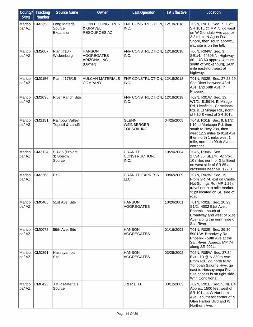
Page 14 Of 39
Maricopa/ AZ
CM0391 Hassayampa Site
HANSON AGGREGATES
03/25/2002 T02N, R05W, Sec. 27,34. Exit I-10 @ N 339th Ave. From I-10, go north to W Tonopah Salome Hwy, go east to Hassayampa River. Site access is on right side. With Conditions.
Maricopa/ AZ
CM0423 J & R Materials Source
J & R LTD. 03/12/2003 T02N, R01E, Sec. 5, NE1/4. Approx. 1500 feet west of SR 101L at W Northern Ave.; southeast corner of N Glen Harbor Blvd and W Northern Ave.
Maricopa/ AZ
CM0073 59th Ave. Site HANSON AGGREGATES
01/16/2003 T01N, R02E, Sec. 29,30. 5901 W. Broadway Rd., Phoenix - 59th Ave at the Salt River. Approx. MP 74 along SR 202L.
Maricopa/ AZ
CM2007 Plant #10 - Wickenburg
HANSON AGGREGATES ARIZONA, INC (Owner)
FNF CONSTRUCTION, INC.
12/18/2018 T06N, R04W, Sec. 3, SE1/4. 44605 N. Highway 60 - US 60 approx. 4 miles south of Wickenburg, 1/8th mile east-northeast of highway.
Maricopa/ AZ
CM0156 Plant #175/18 VULCAN MATERIALS COMPANY
FNF CONSTRUCTION, INC.
12/18/2018 T01N, R02E, Sec. 27,28,29. Salt River between 43rd Ave. and 59th Ave. in Phoenix.
Maricopa/ AZ
CM0405 51st Ave. Site HANSON AGGREGATES
10/26/2001 T01N, R02E, Sec. 20,29, S1/2. 4002 51st Ave., Phoenix - south of Broadway and west of 51st Ave. along the north side of Salt River.
Maricopa/ AZ
CM2353 Long Material Source Expansion
JOHN F. LONG TRUST & GRAVEL RESOURCES AZ
FNF CONSTRUCTION, INC.
12/18/2018 T02N, R01E, Sec. 7. Exit SR 101L @ MP 7, go west on W Glendale Ave approx. 2.2 mi. to N Agua Fria Shore, then south approx1 mi., site is on the left.
Maricopa/ AZ
CM2124 SR-85 (Project 3) Borrow Source
GRANITE CONSTRUCTION, INC.
10/20/2004 T04S, R04W, Sec. 27,34,35, SE1/4. Approx. 10 miles north of Gila Bend on west side of SR 85 at crossover near MP 127.8.
Maricopa/ AZ
CM2263 Pit 2 GRANITE EXPRESS LLC
09/02/2009 T07N, R02W, Sec. 19. From SR 74, exit on Castle Hot Springs Rd (MP 1.26); travel north to mile marker 9; pit located on SE side of road.
Maricopa/ AZ
CM2035 River Ranch Site FNF CONSTRUCTION, INC.
12/18/2018 T02N, R01W, Sec. 13, W1/2. 5159 N. El Mirage Rd, Litchfield - Camelback Rd. & El Mirage Rd., north of I-10 & west of SR 101L.
Maricopa/ AZ
CM2151 Rainbow Valley Topsoil & Landfill
GLENN WEINBERGER TOPSOIL INC.
04/25/2005 T04S, R01E, Sec. 8, E1/2. I-10 to Maricopa Rd, then south to Hwy 238, then west 12.5 miles to 91st Ave, then north 1 mile, west 1 mile, north on 99 th Ave to entrance.
County/ State
Tracking Number
Source Name Owner Last Operator EA Effective Location

Page 15 Of 39
Maricopa/ AZ
CM2115 Estrella Plant KILAUEA CRUSHERS INC.
06/10/2004 T02S, R03W, Sec. 1,2,11,12. Take Jackrabbit Trail exit off I-10, travel 12 miles south to plant entrance.
Maricopa/ AZ
CM0183 Plant One FORT McDOWELL YAVAPAI MATERIALS
K.A.Z. CONSTRUCTION, INC.
04/11/2019 T03N, R07E, Sec. 17,18,19. 2 miles north of Hwy 87 bridge on the Verde River in Fountain Hills. With Conditions.
Maricopa/ AZ
CM2240 Jackrabbit Aggregates
LAFARGE CORPORATION
01/13/2009 T01S, R03W, Sec. 7,12. From I-10 take N Verrado Way/S Verrado Way south approx. 6.8 miles to Beloat Rd, entrance is directly south of intersection.
Maricopa/ AZ
CM2106 Jomax Pit KILAUEA CRUSHERS INC.
04/01/2004 T05N, R01W, Sec. 34. North on 99th Ave. to Jomax Rd., west on Jomax to 131st Ave.
Maricopa/ AZ
CM2211 New River Quarry
JAKE'S GRANITE SUPPLIES, LLC
12/17/2007 T07N, R02E, Sec. 34, SW1/4. From I-17, take New River Rd. Exit (232), go east to N Black Canyon Hwy; go south on N Black Canyon Hwy approx. 3/4 mile, site on east side of road.
Maricopa/ AZ
CM0184 Fort McDowell Yavapai Materials pit #3
FORT McDOWELL YAVAPAI MATERIALS
K.A.Z. CONSTRUCTION, INC.
04/11/2019 T03N, R06E, Sec. 25,27,36, SW1/4. 1/8 mile northeast of the intersection of Shea Blvd. and SR 87.
Maricopa/ AZ
CM2133 Buckeye Pit JAKE'S GRANITE SUPPLIES, LLC.
11/29/2004 T01S, R03W, Sec. 11. Go east on W Beloat Rd (W Lower River Rd) approx 5.4 miles to site entrance on south side.
Maricopa/ AZ
CM2021 Plant #3 - Cave Creek
LAFARGE CORPORATION
02/19/2008 T04N, R03E, Sec. 27, NW1/4. 19636 N. 20th St, Phoenix - take SR 101L to Cave Creek Rd., south 0.5 miles to Beardsley Rd, west for 0.5 mile, then south on 20th St. for 0.5 mile.
Maricopa/ AZ
CM2284 Madison Granite Supplies
MADISON GRANITE SUPPLY
MEADOW VALLEY CONTRACTORS, INC
10/09/2015 T05N, R02E, Sec. 24, SE1/4. North on I-17 to Dixateta Dr then east on Dixateta Dr to Scale House.
Maricopa/ AZ
CM0202 Sun City Aggregates
LAFARGE CORPORATION
10/03/2008 T04N, R01W, Sec. 24,25, SE1/4. From SR 101, take Union Hills west to 83rd Ave., north on 83rd Ave. to Beardsley; west on Beardsley to plant at 115th Ave. & Beardsley Rd.
Maricopa/ AZ
CM0351 Buckey MISSION MATERIALS COMPANY
01/27/2009 T02S, R05W, Sec. 27,34. From SR 85, take Exiit 138; go west on W Patterson Rd approx. 4 miles to Old US 80, go north on Old US 80 approx. 3.6 miles to site on left.
County/ State
Tracking Number
Source Name Owner Last Operator EA Effective Location

Page 16 Of 39
Maricopa/ AZ
CM2250 Phoenix San-Man Sun City Plant 12
PHOENIX SAN-MAN INC.
05/13/2009 T04N, R01E, Sec. 18,19. SR 303L: west on W Happy Valleey Pkwy; south on N 107th Ave; south on Agua FriaTruck Rd Reliever; west on W Rose Garden Ln to pit on N 115 h Ave.
Maricopa/ AZ
CM2036 Navajo Red Pit PIONEER LANDSCAPING MATERIALS
12/11/2003 T06N, R03W, Sec. 2,11. At SR 74 approx. 0.75 miles west of 211th Ave, turn north on dirt road, approx. 2 miles to pit.
Maricopa/ AZ
CM2249 Hassayampa Plant #10 (Phx San Man)
PIONEER LANDSCAPING MATERIALS, INC.
04/08/2009 T02N, R05W, Sec. 14. I-10 Exit 109, go north on Palo Verde (Sun Valley Pkwy), go west on McDowell/Tonopah Salome Hwy, go north on 315th Ave 3 miles to pit road on left.
Maricopa/ AZ
CM2285 Paloma Ready Mix & Materials
PALOMA READY MIX & MATERIALS, LLC
09/23/2010 T05S, R04W, Sec. 9, SE1/4. SR 85 @ approx. MP 120.3, go 4.2 miles on Old US Highway 80 to site on left.
Maricopa/ AZ
CM2184 Phoenix San-Man Buckeye Plant #24
PHOENIX SAN-MAN INC.
03/02/2009 T01S, R03W, Sec. 9, SW1/4. South of Buckeye, Take W Hazen Rd east to S Miller Rd; turn south and go 1/4 mile to Sunrise Dr; go east on Haul Rd. (Sunrise Dr.), 1 mile to office.
Maricopa/ AZ
CM0072 Cemex Material Plant #106
CEMEX CONSTRUCTION MATERIALS SOUTH LLC
PULICE CONSTRUCTION INC.
07/25/2019 T03N, R01W, Sec. 36, W1/2. 8507 N. El Mirage Road, Glendale.
Maricopa/ AZ
CM2389 Beeline BC1/BC2 Material Source
TRIBAL LAND - SALT RIVER MATERIALS GROUP
PULICE CONSTRUCTION, INC.
08/22/2019 T02N, R05E, Sec. 26,34,35. From Mesa, take SR 87 to W McDowell Rd, exit east to the project site (no locked gate but Tribal land requires authorization).
Maricopa/ AZ
CM2218 Dobson Facility TRIBAL LAND - SALT RIVER MATERIALS GROUP
PULICE CONSTRUCTION, INC.
08/22/2019 T01N, R05E, Sec. 7,8. From SR 101L in Scottsdale, take E McKellips Rd east for approx. 0.5 mile, then turn south on access road.
Maricopa/ AZ
CM0166 Higley Road Plant
DRAKE AGGREGATES
PREACH INCORPORATED
08/22/2019 T02N, R06E, Sec. 34, NE1/4. 3410 N. Higley Road, Mesa.
Maricopa/ AZ
CM2413 Cemex 75th Ave Pit
CEMEX CONSTRUCTION MATERIALS SOUTH L.L.
PULICE CONSTRUCTION
02/03/2021 T01N, R01E, Sec. 25,36. From I-10 go south on SR 202L, exit on W Southern Ave. Go west 1.2 miles to the site.
Maricopa/ AZ
CM0059 Materials Plant 5 and Plant 11
CEMEX CONSTRUCTION MATERIALS SOUTH LLC
PULICE CONSTRUCTION
06/05/2020 T01N, R02E, Sec. 24. Plant 11 is at 3640 S. 19th Ave., Plant 5 is at 5150 S. 27th Ave., Phoenix.
County/ State
Tracking Number
Source Name Owner Last Operator EA Effective Location

Page 17 Of 39
Maricopa/ AZ
CM2155 7th Street Processing Area
UNITED METRO / RINKER
05/17/2005 T04N, R03E, Sec. 17, NE1/4. From SR 101L @ Exit 26, travel north on N 7th St approx 1.9 miles to E Pinnacle Peak Rd, go west approx 0.50 mile to site entrance on right.
Maricopa/ AZ
CM2098 7th St. Concrete Batch Plant #107
UNITED METRO / RINKER
02/26/2004 T04N, R03E, Sec. 21, NW1/4. From SR 101L @ Exit 26 travel north on N 7th St approx. 3/4 mi to site on right. Site is south of Cave Creek Wash and east 0f N.7th St.
Maricopa/ AZ
CM2037 Ft. Mountain 1405 MINE LLP SUNLAND ASPHALT & CONSTRUCTION, INC.
01/11/2021 T04N, R03E, Sec. 9. N 7 th St, north of E Deer Valley Rd.
Maricopa/ AZ
CM0424 Buckeye Pit RIVER MINING, LLC 04/15/2003 T01S, R03W, Sec. 8,9,17. Take I-10 to Miller Rd. exit, south on S Miller Rd. for 6 miles to Sunrise Dr., east on Sunrise Dr. for approx. 0.75 miles.
Maricopa/ AZ
CM2055 Higley Material Source-CM2055-Expansion
TRIBAL LAND - SALT RIVER MATERIALS GROUP
PULICE CONSTRUCTION, INC.
08/22/2019 T02N, R06E, Sec. 21-23,27-29. From Mesa, take SR 202L east to Higley Rd, then north 0.15 miles to Salt River Materials Group Access Road, then west 0.50 mile to office.
Maricopa/ AZ
CM2228 Bass Hill SUN MOUNTAIN DEVELOPMENT LLC
06/10/2008 T07N, R05W, Sec. 1, SE1/4. From US 60 in Wickenburg, take El Recreo Dr. east to Bass Rd., go eat approx. 0.25 mile to site.
Maricopa/ AZ
CM2221 Buckeye Plant SALT RIVER MATERIALS GROUP
03/12/2008 T01S, R03W, Sec. 19. Take I-10 to SR 85, south on SR 85 to MP 146.9 (Narramore Rd), east & then north on Narramore Rd to site just past Buckeye Plant #4 CM0425. With Conditions.
Maricopa/ AZ
CM2402 Eagle Mountain Pit
PARKER, TR EAGLE MOUNTAIN GROUP
SOUTHWEST ROCK PRODUCTS
12/11/2018 T01S, R03W, Sec. 23, E1/2. SR 85 MP 150, go east on MC85 to Jackrabbit Rd, Go south 4 miles +/- to Narramore Rd, Go west on Narramore Rd to Dean Rd. Site is on southwest corner.
Maricopa/ AZ
CM0354 Parcels 1 & 2 in the Beeline Pit
SALT RIVER SAND & ROCK
07/28/2003 T02N, R05E, Sec. 24,25,26. West of Gilbert Rd. on SR 87, south side, Milepost 181.
Maricopa/ AZ
CM2189 Olive Avenue Plant
SALT RIVER MATERIALS GROUP
05/04/2007 T03N, R01W, Sec. 25. From SR 101L go west on W Olive Ave approx. 3.3 miles. Site is north of W Olive Ave at the Agua Fria River.
County/ State
Tracking Number
Source Name Owner Last Operator EA Effective Location
Page 18 Of 39
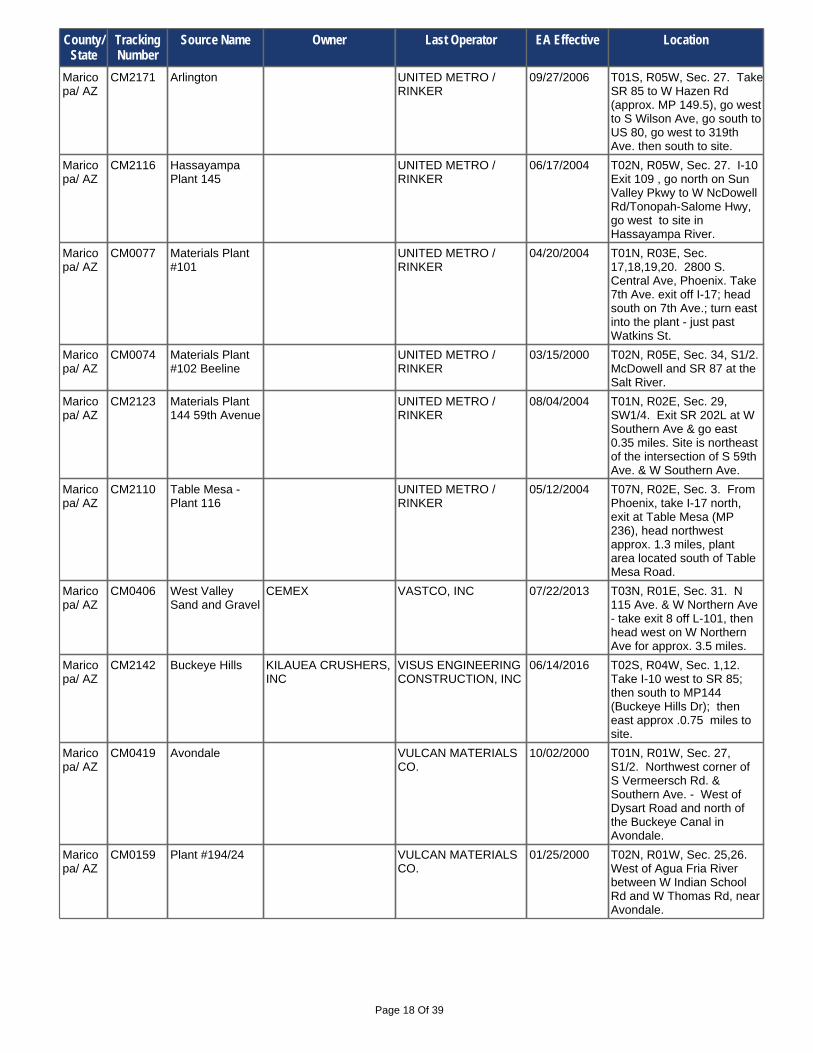
Maricopa/ AZ
CM2123 Materials Plant 144 59th Avenue
UNITED METRO / RINKER
08/04/2004 T01N, R02E, Sec. 29, SW1/4. Exit SR 202L at W Southern Ave & go east 0.35 miles. Site is northeast of the intersection of S 59th Ave. & W Southern Ave.
Maricopa/ AZ
CM0074 Materials Plant #102 Beeline
UNITED METRO / RINKER
03/15/2000 T02N, R05E, Sec. 34, S1/2. McDowell and SR 87 at the Salt River.
Maricopa/ AZ
CM0406 West Valley Sand and Gravel
CEMEX VASTCO, INC 07/22/2013 T03N, R01E, Sec. 31. N 115 Ave. & W Northern Ave - take exit 8 off L-101, then head west on W Northern Ave for approx. 3.5 miles.
Maricopa/ AZ
CM2110 Table Mesa - Plant 116
UNITED METRO / RINKER
05/12/2004 T07N, R02E, Sec. 3. From Phoenix, take I-17 north, exit at Table Mesa (MP 236), head northwest approx. 1.3 miles, plant area located south of Table Mesa Road.
Maricopa/ AZ
CM2171 Arlington UNITED METRO / RINKER
09/27/2006 T01S, R05W, Sec. 27. Take SR 85 to W Hazen Rd (approx. MP 149.5), go west to S Wilson Ave, go south to US 80, go west to 319th Ave. then south to site.
Maricopa/ AZ
CM0077 Materials Plant #101
UNITED METRO / RINKER
04/20/2004 T01N, R03E, Sec. 17,18,19,20. 2800 S. Central Ave, Phoenix. Take 7th Ave. exit off I-17; head south on 7th Ave.; turn east into the plant - just past Watkins St.
Maricopa/ AZ
CM2116 Hassayampa Plant 145
UNITED METRO / RINKER
06/17/2004 T02N, R05W, Sec. 27. I-10 Exit 109 , go north on Sun Valley Pkwy to W NcDowell Rd/Tonopah-Salome Hwy, go west to site in Hassayampa River.
Maricopa/ AZ
CM2142 Buckeye Hills KILAUEA CRUSHERS, INC
VISUS ENGINEERING CONSTRUCTION, INC
06/14/2016 T02S, R04W, Sec. 1,12. Take I-10 west to SR 85; then south to MP144 (Buckeye Hills Dr); then east approx .0.75 miles to site.
Maricopa/ AZ
CM0159 Plant #194/24 VULCAN MATERIALS CO.
01/25/2000 T02N, R01W, Sec. 25,26. West of Agua Fria River between W Indian School Rd and W Thomas Rd, near Avondale.
Maricopa/ AZ
CM0419 Avondale VULCAN MATERIALS CO.
10/02/2000 T01N, R01W, Sec. 27, S1/2. Northwest corner of S Vermeersch Rd. & Southern Ave. - West of Dysart Road and north of the Buckeye Canal in Avondale.
County/ State
Tracking Number
Source Name Owner Last Operator EA Effective Location

Page 19 Of 39
Maricopa/ AZ
CM2002 Val Vista Materials
VULCAN LANDS INC. VULCAN MATERIALS COMPANY
10/05/2017 T02N, R06E, Sec. 32, NE1/4. South of L 202 on Val Vista Road - southwest corner of Val Vista Rd. and Virginia Ave.
Maricopa/ AZ
CM2371 West Coast Sand & Gravel Avondale
QUINN ENTERPRISES, LP
WEST COAST SAND & GRAVEL, INC.
06/21/2018 T01N, R01W, Sec. 34, NE1/4. Exit I-10 at Avondale Blvd, go south 4.7 miles to W Southern Ave, go west 2.1 miles, pit is @ SW corner of S Vermeersch Rd & W Southern Ave.
Maricopa/ AZ
CM2232 Western Aggregates Buckeye Plant #41
WESTERN AGGREGATES
09/04/2008 T01N, R05W, Sec. 26,27,34,35. From SR 85 (MP 152) near Buckeye, travel west on W Southern Ave to pit at end of road at the Hassayampa River (near 318th Ave.).
Maricopa/ AZ
CM2001 Sun City 80 Gravel Pit
VULCAN MATERIALS CO.
06/20/2003 T04N, R01E, Sec. 7,18. SR 303L, go east on W Happy Valley Pkwy; go south on N 117th Ave to N 115 th Ave; go south to W Hatfield Rd. Corner of W Hatfield Dr & N 115th Ave.
Maricopa/ AZ
CM2385 Gila 240 Materials Source
VULCAN MATERIALS COMPANY (Land Manager)
VULCAN MATERIALS COMPANY
10/01/2020 T01N, R01W, Sec. 35, N1/2. I-10 @ Exit 131, go south on S. Avondale Blvd. to W. Southern Ave. Go west on W. Southern Ave. 1.7 miles to entrance on south side @ S 129th Ave.
Maricopa/ AZ
CM0167 Vulcan Material Company
VULCAN MATERIALS COMPANY
WSP, INC. 08/22/2019 T01N, R01E, Sec. 25. From I-10 Exit 137 go south on N. 67 th Ave. to W. Broadway Rd. then west to 7845 W. Broadway Rd.
Maricopa/ AZ
CM0422 Western Aggregates Gila Bend Plant #42
WESTERN AGGREGATES
05/30/2008 T05S, R04W, Sec. 18, NW1/4. SR 85 to US 80 to Stout Rd, go north 1.3 miles to W Watermelon Rd., go west 1 mile to 307th Ave, go north to Indian Rd, go west to haul road on left.
Maricopa/ AZ
CM2212 Weston 4 WESTON CONCRETE AND MATERIALS, INC.
12/20/2007 T07N, R04W, Sec. 28, SE1/4. Site is approximately 10 miles south of Wickenburg on US 60, on east side of road, at 47447 N US Hwy 60, Morristown.
Maricopa/ AZ
CM2230 Hassayampa WISH 07/02/2008 T08N, R05W, Sec. 35,36. From Wickenburg, take US 93 north to Rincon Rd; turn right on Rincon Rd.; then turn right on Jack Burden Rd., site is in the Hassayampa River.
County/ State
Tracking Number
Source Name Owner Last Operator EA Effective Location

Page 20 Of 39
Mohave/ AZ
CM2137 Blake Material Source
BILL BLAKE FNF CONSTRUCTION INC.
02/07/2019 T21N, R13W, Sec. 23,26. 22 miles east of Kingman and north of I-40, off of US 93.
Mohave/ AZ
CM2009 Caithness Borrow Pit
AZ BIG SANDY LLC FNF CONSTRUCTION, INC
05/01/2019 T15N, R13W, Sec. 12, SW1/4. Approx. 4.1 miles south of Wikieup on west side of US 93.
Mohave/ AZ
CM0429 Sand Pit D. L. CAMPBELL CO. INC.
FANN CONTRACTING, INC.
05/01/2019 T13N, R18W, Sec. 31, S1/2. North of SR 95 near MP 172, approx. 9 miles southeast of Lake Havasu City, at Standard Wash.
Mohave/ AZ
CM2017 Nace Material Source
FISHER SAND & GRAVEL
10/21/2003 T16N, R20W, Sec. 13, E1/2. Approx. 2000 feet east of SR 95, south of I-40.
Mohave/ AZ
CM0292 McCall Materials Source
McCALL CONSTRUCTION
04/18/2003 T21N, R17W, Sec. 11. 3199 Fort Beale Dr. - From I-40 in Kingman, take Hwy 93 north to Fort Beale Dr., travel 2 miles northwest, located behind dairy.
Mohave/ AZ
CM2347 Duey Material Source and Plant Site
AMES CONSTRUCTION, INC.
03/03/2014 T19N, R13W, Sec. 33. From US 93 north of Wikieup, enter unnamed access road east @ MP 103.5 for 0.35 mi, then south approx. 0.8 mi to material source.
Mohave/ AZ
CM2066 Lake Havasu City MS
BECKER - MEALEY, LLC dba VAL ROCK
12/31/2003 T13N, R19W, Sec. 25, W1/2. From Lake Havasu City take SR 95 to approx.MP 174.5, take road entrance on left east/northeast to site.
Mohave/ AZ
CM2170 Truxton Wash Materials Source
DESERT CONSTRUCTION, INC.
DESERT CONSTRUCTION, INC.
03/30/2016 T23N, R14W, Sec. 11,14. North of US 66, approx. 24 miles NE of Kingman and 2 miles northwest of Hackberry, in Truxton Wash.
Mohave/ AZ
CM2150 McConnico Pit BLM Community Pit 04/08/2005 T20N, R17W, Sec. 6. Exit I-40 at McConnico TI (MP 44), go west on Shinarump Rd approx 1.25 miles, site is south of Shinarump Rd. at Sacramento Wash.
Mohave/ AZ
CM0428 Kingman Pit BLM (St. George) D&B OF LAKE HAVASU dba D&R EXCAVATING
05/22/2008 T21N, R15W, Sec. 19. Take I-40, 8 miles east of Kingman, exit 59 - DW Ranch Rd, turn south, south in first dirt driveway, follow signs to pit.
Mohave/ AZ
CM0021 Hualapai Pit DESERT CONSTRUCTION INC.
05/09/2000 T21N, R16W, Sec. 29. Off Hualapai Mountain Road.
Mohave/ AZ
CM0348 Silver Tank Quarry
CHARLES HAMILTON TRUST
12/16/2003 T24N, R19W, Sec. 35. On west side of US 93, approx. 1 mile north of Grasshopper Jct.
Mohave/ AZ
CM0370 Beaver Dam CONTINENTAL MATERIALS BEAVER DAM LLC
05/17/2012 T41N, R15W, Sec. 29,30. Mohave Co. 91 and Biasi Ranch Rd.
County/ State
Tracking Number
Source Name Owner Last Operator EA Effective Location

Page 21 Of 39
Mohave/ AZ
CM2012 Cofer Materials Pit
ROAD RUNNER REALTY CORP. (LEO A. HORNER)
07/10/2009 T20N, R13W, Sec. 21,27,28. US 93 MP 96 (20 miles north of Wikieup), travel 1 mile east on Hackberry Road to pit area. Site is located in Section 27.
Mohave/ AZ
CM2118 Forrest Purdy Pit No. 2
R.E. MONKS CONSTRUCTION
07/06/2004 T15N, R13W, Sec. 1, SE1/4. 3 miles south of Wikieup on east side of US 93, east side of Big Sandy River and US 93.
Mohave/ AZ
CM2295 Hackberry Pit CAMPBELL REDI-MIX SHOW LOW CONSTRUCTION, INC.
05/18/2020 T23N, R14W, Sec. 13,14,24. From Kingman travel north on SR 66 to MP 80. Turn right onto access/haul road. Follow road under railroad bridge to site.
Mohave/ AZ
CM0438 Cedar Hills Quarry
C.S. McCROSSAN, INC
SHOW LOW CONSTRUCTION, INC.
08/03/2021 T21N, R14W, Sec. 20. 9376 E. Wright Rd. - travel 12 miles east of Kingman on I-40 to exit 66, turn north on Blake Ranch Rd. exit, travel northwest 1.1 miles.
Mohave/ AZ
CM2119 R & G Sand & Gravel Pit
R & G DEVELOPMENT
07/06/2004 T15N, R20W, Sec. 13,14. Approx. 13.5 miles north of Lake Havasu City, 0.3 miles east of SR 95.
Mohave/ AZ
CM2204 Lake Havasu McCORMICK CONSTRUCTION CO.
09/27/2007 T15N, R20W, Sec. 27,28. Travel 5 miles noth of Lake Havasu on SR 95, entrance is 0.2 miles south of MP 193.
Mohave/ AZ
CM2101 Thumb Butte Q & D PROPERTIES 10/22/2012 T21N, R20W, Sec. 29,32. From Bullhead City, travel approx. 7 miles east on SR 86; pit located 2 miles south of SR 68.
Mohave/ AZ
CM2145 Dunton Material Source
SCOTT DUNTON PRECISION AGGREGATE PRODUCTS LLC
02/16/2017 T21N, R10W, Sec. 19, NE1/4. East of Kingman; about 18 miles east of US 93/I-40 @ I-40 Exit 91, go 1600 ft north of I-40 on Fort Rock Rd, site is on left.
Mohave/ AZ
CM0372 Aztec Quarry SOUTHERN ARIZONA PAVING & CONSTRUCTION
03/13/2003 T21N, R18W, Sec. 23. Site is approx 2 miles south of SR 68 on east side of Aztec Rd.
Mohave/ AZ
CM2210 Beaver Dam Pit SUNROC CORP. 12/07/2007 T41N, R15W, Sec. 29, NE1/4. From I-15 in Littlefield, travel approximately 2 miles north on old US 91, pit is located on west side of road.
Mohave/ AZ
CM0214 Calf Properties Section 13
STOCKBRIDGE NORTHWEST, INC.
11/10/2009 T20N, R22W, Sec. 13, SE1/4. From SR 95 MP 246.1, turn east on Silver Creek Road, then north on Plata Caleta Rd to site.
County/ State
Tracking Number
Source Name Owner Last Operator EA Effective Location

Page 22 Of 39
Mohave/ AZ
CM0440 JDI Pit THUNDERBIRD MATERIALS, LLC
05/01/2017 T21N, R15W, Sec. 17, SW1/4. I-40 east of Kingman near MP 60, Dw Ranch Rd exit, north.
Mohave/ AZ
CM0392 Materials Plant 881
UNITED METRO / RINKER
03/15/2000 T19N, R22W, Sec. 21. 1101 Aztec Road, Fort Mohave - about 1/2 mile west of SR 95 & Aztec Road.
Mohave/ AZ
CM0312 Havasu Pit VAL-ROCK INC. 04/06/2005 T13N, R19W, Sec. 26. 1 mile south of Sara Park at approx. MP 174.4 off of SR 95, south of Lake Havasu City.
Mohave/ AZ
CM2043 Santa Fe Pit SUNSHINE CONCRETE & MATERIALS, INC.
01/26/2007 T15N, R20W, Sec. 23, NW1/4. Approx. 6 miles north of Desert Hills, AZ on east side of SR 95.
Mohave/ AZ
CM2045 Airport Pit SUNSHINE CONCRETE & MATERIALS, INC.
04/24/2007 T14N, R20W, Sec. 11. Turn right at approx. MP 188.7 on to Business Park Way, go to Whelan Dr then go right on Whelan Dr and take it to site.
Mohave/ AZ
CM2044 Kingman Pit POLIDORI SUNSHINE CONCRETE & MATERIALS, INC.
01/26/2007 T21N, R17W, Sec. 34, SE1/4. South from Kingman, exit off I-40 at approx. MP 44. Take Shinarump Rd west to Oatman Rd, then northesterly to site on west side of Oatman Rd.
Navajo/ AZ
CM2260 Cooley Knoll Cinder Pit
BRIMHALL SAND, ROCK & BUILDING MATERIALS
08/04/2009 T11N, R22E, Sec. 25, NW1/4. From SR 77 in Taylor, go 0.7 miles east on Center St, then 12.2 miles south on Love Lake Road (Bordon Ranch Rd), then 0.4 miles west to entrance.
Mohave/ AZ
CM0390 Hughes Borrow Pit
WESTERN ROCK PRODUCTS CORP.
04/21/2000 T39N, R16W, Sec. 3. East of Oasis Golf course, south of I-15, north of Virgin River.
Mohave/ AZ
CM0263 Bullhead City Pit CALF PROPERTIES VISUS ENGINEERING CONSTRUCTION, INC
05/09/2018 T20N, R21W, Sec. 18. 1950 Bullhead Pkwy, Bullhead City; located in Silver Creek Wash north of Silver Creek Rd. and east of SR 95.
Mohave/ AZ
CM0412 Pass Canyon S&S CONCRETE & MATERIALS, LLC
VISUS ENGINEERING CONSTRUCTION, INC
01/19/2017 T20N, R21W, Sec. 7. From Bullhead City, go south past city park to Pass Canyon Rd., go east 1.5 miles to plant site.
Mohave/ AZ
CM2056 Mohave Pit CEMEX CONSTRUCTION MATERIALS SOUTH, LLC
VULCAN MATERIALS COMPANY
07/24/2019 T20N, R21W, Sec. 22, SE1/4. At MP 246 on SR 95 go approx. 5 miles east on Silver Creek Road. Site is north of Silver Creek Wash.
County/ State
Tracking Number
Source Name Owner Last Operator EA Effective Location

Page 23 Of 39
Navajo/ AZ
CM2333 Snowflake Pit HATCH CONSTRUCTION & PAVING, INC.
HATCH CONSTRUCTION & PAVING INC.
06/20/2019 T13N, R21E, Sec. 14,15. From the Town of Snowflake, take SR 277 for 1.5 miles west to Industrial Way, then 0.5 miles north on Industrial Way to site access road.
Navajo/ AZ
CM2313 McLaws Plantsite
HATCH CONSTRUCTION & PAVING, INC.
09/27/2013 T17N, R20E, Sec. 12, SE1/4. From Holbrook, I-40 Exit 286, Take SR 77 south approx. 1.25 miles to approx. MP 387.3, then take access road on the right to site.
Navajo/ AZ
CM2308 Quality R/M Holbrook Yard
BRIMHALL SAND, ROCK & BUILDING MATERIALS
11/29/2011 T17N, R20E, Sec. 12, SE1/4. From Holbrook take SR 77 south 1 mile, site is 500 feet west of SR 77.
Navajo/ AZ
CM2077 Winslow Materials Source
BRIMHALL SAND, ROCK & BUILDING MATERIALS
01/09/2004 T19N, R16E, Sec. 27, S1/2. Located just east of SR 87, approx. 0.5 miles north of the Polacca Interchange on I-40 at MP 257.5, north of Winslow.
Navajo/ AZ
CM2050 Minnetonka Pit McCAULEY DVLPMT/DYNA ROCK & SAND INC.
FNF CONSTRUCTION INC.
03/25/2021 T19N, R16E, Sec. 27. From intersection of I-40 and SR 87, travel 0.25 miles north on SR 87, entrance on west side of road.
Navajo/ AZ
CM2287 Joe's Pit BRIMHALL SAND, ROCK & BUILDING MATERIALS
BRIMHALL SAND, ROCK & BUILDING MATERIALS
12/17/2010 T12N, R21E, Sec. 6, N1/2. Highway 277 - Turn southeast on Papermill Rd. - Approximately 5 miles to Gene Taylor Ranch Road - south 1/4 mile.
Navajo/ AZ
CM2300 Jeffers Plantsite JEFFERS CATTLE CO., INC
FANN CONTRACTING, INC.
04/28/2016 T18N, R21E, Sec. 1, SE1/4. From I-40 at Sun Valley, take Exit 294 (Sun Valley Road) north 0.21 miles to southeast corner of existing plantsite (on left).
Navajo/ AZ
CM2051 Chevelon Pit McCAULEY DVLPMT/DYNA ROCK & SAND INC.
FNF CONSTRUCTION INC.
03/25/2021 T16N, R16E, Sec. 11, S1/2. South of Winslow at MP 29.5 on SR 99, east on Thunder Rd., south on Colt Rd., east on Pinto Rd. to pit.
Navajo/ AZ
CM0017 Cottonwood Wash North Pit
BRIMHALL SAND, ROCK & BUILDING MATERIALS
FNF CONSTRUCTION INC.
07/07/2021 T13N, R21E, Sec. 14,22,23. West of SR 77 & along SR 277, Snowflake. (Includes pit locations north and south of SR 277 - in and west of Cottonwood Wash.).
Navajo/ AZ
CM2259 Kayenta Hot Plant Site
FANN CONTRACTING, INC.
08/04/2009 T38N, R20E, Sec. 7, SW1/4. From the town of Kayenta, travel SE on US 163 (Main Street) to US 160; travel east on US 160 for 0.86 miles to plant site on right..
Navajo/ AZ
CM0267 Bidahochi Hard Luck Materials Source
BRIMHALL SAND & ROCK INC.
FNF CONSTRUCTION INC.
03/25/2021 T23N, R21E, Sec. 11. Approx. 0.75 miles west of SR 77.
County/ State
Tracking Number
Source Name Owner Last Operator EA Effective Location

Page 24 Of 39
Navajo/ AZ
CM2315 Joseph City Plantsite - 1986
QUALITY READY MIX QUALITY READY MIX 07/30/2018 T18N, R19E, Sec. 18, SE1/4. Site located at 4295 Frontage Rd. along I-40 at Exit 274.
Navajo/ AZ
CM0427 Linden-Pearce Material Source
PERKINS CINDERS, INC.
PERKINS CINDERS, INC.
04/20/2012 T11N, R21E, Sec. 33. 1020 Pearce Road, Show Low - 1 mile north of SR 260 at Pearce Road.
Navajo/ AZ
CM2309 Taylor Pit PERKINS CINDERS, INC.
SHOW LOW CONSTRUCTION, INC.
09/10/2015 T13N, R21E, Sec. 34, N1/2. From SR 77 in Taylor AZ, go west on Paper Mill Road approximately 0.8 miles to haul road entrance on north side.
Navajo/ AZ
CM2317 Kayenta Plantsite - 1988
QUALITY READY MIX QUALITY READY MIX 11/01/2018 T38N, R20E, Sec. 18, NW1/4. Site is located along US 160 @ approximate MP 394.4 on south side of road.
Navajo/ AZ
CM2087 Aztec Material Source
HEBER MATERIALS, LLC.
01/13/2004 T14N, R18E, Sec. 26, W1/2. West of SR 377 at approx. MP 9.1.
Navajo/ AZ
CM2099 Quality Ready Mix - Show Low Plant
QUALITY READY MIX J. BANICKI CONSTRUCTION, INC.
05/03/2021 T10N, R22E, Sec. 16, SW1/4. West side of SR 77 at US 60. Show Low, AZ.
Navajo/ AZ
CM2086 Turley Materials Source
HEBER MATERIALS, LLC.
01/03/2004 T13N, R18E, Sec. 2. Approx. 0.5 miles east of SR 377 at MP 6.9.
Navajo/ AZ
CM2062 Bear Canyon No. 1, Limestone Quarry
WHITE MOUNTAIN APACHE TRIBE
01/07/2004 T06N, R22E, Sec. 26, NE1/4. From SR 73 @ MP 333.8, travel north 7 miles +/- on W Bear Canyon Rd/43rd Rd/IR 47 to site.
Navajo/ AZ
CM0284 Geronimo Materials Source
BRIMHALL SAND ROCK & BUILDING MATERIALS
VASTCO 03/01/2016 T18N, R20E, Sec. 29. Approx. 1 mile northeast of the Geronimo TI exit on I-40 at MP 280.
Navajo/ AZ
CM2063 Carrizo II WHITE MOUNTAIN APACHE TRIBE
01/07/2004 T08N, R19E, Sec. 35. On US 60, turn west at Carrizo Community, then north on BIA 35 (IR 35) for 4 miles, pit on left side of road.
Navajo/ AZ
CM2058 Four Mile Wash Pit
HATCH CONSTRUCTION & PAVING, INC.
SUNLAND ASPHALT & CONSTRUCTION, LLC
06/29/2021 T12N, R21E, Sec. 5. 4 miles west of Taylor south of Paper Mill Rd.
Navajo/ AZ
CM2365 Thunder Material Source
HATCH CONSTRUCTION & PAVING, INC.
SUNLAND ASPHALT 06/29/2021 T10N, R22E, Sec. 15, SE1/4. Site is within City of Show Low, approx. 1.5 miles east of the intersection of SR 77 & US 60, immediately on the south side of the highway.
Navajo/ AZ
CM2100 Heber Batch Plant 702
UNITED METRO / RINKER
02/26/2004 T12N, R16E, Sec. 13, SW1/4. 1801 S. Hwy 260; west of Heber on south side of SR 260.
Navajo/ AZ
CM2203 Owens Pit PERKINS CINDERS, INC
SUNLAND ASPHALT INC
05/21/2020 T10N, R22E, Sec. 23, NE1/4. Travel east of Show Low on US 60 to approx. MP 344.7; entrance to pit is on south side of road.
County/ State
Tracking Number
Source Name Owner Last Operator EA Effective Location

Page 25 Of 39
Navajo/ AZ
CM2165 Gold Gulch Materials Pit
WHITE MOUNTAIN APACHE TRIBE
08/16/2000 T06N, R23E, Sec. 28, SE1/4. From Whiteriver take SR 73 north to MP 342.75, turn east on IR 61 & go approx. 0.50 mile to N Fish Hatchery Rd, take N Fish Hatchery Rd east to site.
Nevada CM2377 El Dorado Material Source
EL DORADO ROCK & SAND LLC
FISHER SAND & GRAVEL CO.
03/27/2018 T23S, R63E, Sec. 11, NW1/4. Take US 93 west of Boulder City, NV to US 95, then south 0.6 mi. to Silver Line Rd, then 0.75 mi. west to Old US 95, then north 0.3 mi. to entrance.
New Mexico
CM2422 McGaffey Pit JEANNIE & MICKEY FUHS
MICHELE'S READY MIX ROCK & RECYCLE INC.
05/13/2021 T13N, R15W, Sec. 32, NW1/4. Fort Wingate exit I-40, go south on NM400/McGaffey Lake Rd/CR12 for 17.8 mi. At intersection go right on CR402 & travel 0.5 mi. Site is on south side.
Navajo/ AZ
CM2064 East Stago Material Source
WHITE MOUNTAIN APACHE TRIBE
01/07/2004 T05N, R23E, Sec. 19,30. At approx. MP 337.5 turn east and take E Fatco Rd to IR 44 the turn south onto E Fork Rd to site on east side of E Fork Rd.
Nevada CM2279A Mesquite Community Pit
PRECISION AGGREGATE PRODUCTS LLC
04/05/2010 T13S, R71E, Sec. 20. From Mesquite Blvd., travel south on Riverside for 1.1 mile, then left on White Rock Rd. for approx. 0.5 mile to haul road.
New Mexico
CM2052 Gallup Borrow Source
GALLUP SAND & GRAVEL
12/30/2003 T15N, R18W, Sec. 14. Take I-40 exit 22, northeast of Gallup, and travel 1 mile northeast of exit.
New Mexico
CM2054 LaFarge Fine Aggregate Source
VULCAN MATERIALS COMPANY
MICHELE'S READY MIX ROCK & RECYCLE INC.
07/31/2019 T13N, R04E, Sec. 26,27. I-25 north to Placitas, Rio Rancho exit 242, then 2 miles north on I-25 east frontage road, turn right at the sign and go east about 1 mile.
Nevada CM2201 Bunkerville SUNROC CORP. 09/06/2007 T13S, R70E, Sec. 36, NW1/4. From I-15 in Mesquite, take exit 112 to Nevada Hwy 170, travel to Bunkerville, pit is on south side of road.
Nevada CM2279B Mesquite BLM Community Pit
BJ REES'S ENTERPRISE
SUNROC CORPORATION
02/26/2021 T13S, R71E, Sec. 20, 29. From Mesquite Blvd., travel south on Riverside for 1.1 mile, then left on White Rock Rd. for approx. 0.5 mile to haul road.
County/ State
Tracking Number
Source Name Owner Last Operator EA Effective Location

Page 26 Of 39
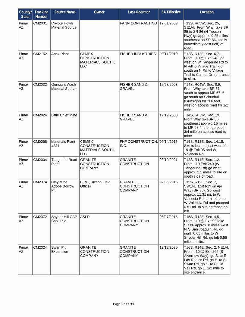
Pima/ AZ
CM0036 Valencia Plant #511 (Formerly Plant 24)
CPC SOUTHWEST MATERIALS
05/03/2000 T15S, R16E, Sec. 19,20. I-10 Exit 275, (Shoughton Rd) go north approx. 3.8 miles to E Valencia Rd. Go east on E Valencia Rd to site in Pantano Wash.
Pima/ AZ
CM2023 Gu Achi Gravel Pit
COMBS CONSTRUCTION COMPANY INC.
09/17/2009 T14S, R03E, Sec. 31, N1/2. From SR 86 @ approx MP 92.3 take IR 15 northeast, go 0.65 mile to haul road entrance on right, take haul road to site.
Pima/ AZ
CM2205 Twin Peaks Pit CALPORTLAND CALPORTLAND 05/21/2020 T12S, R11E, Sec. 26,35. I-10 Exit 246 (Cortaro Rd), west to N Silverbell Rd, take N Silverbell Rd north to W Twin Peaks Rd; go 1.84 miles to entry road to site on left.
Pima/ AZ
CM2319 Kerley Quarry GRANITE CONSTRUCTION CO.
10/06/2020 T17S, R13E, Sec. 21. From I-19 @ Exit 75 (W Sahuarita Rd) go W. 1/4 mi. to South La Canada Rd, go S. 1.3 mi, then turn W. on to W Twin Buttes Rd., go 1.3 mi. to site.
New Mexico
CM2053 San Antonio Quarry
NEW MEXICO STATE LAND OFFICE
MICHELE'S READY MIX ROCK & RECYCLE INC.
10/26/2020 T14N, R12W, Sec. 16 & 17. Thoreau, NM - North 6.3 miles on NM Hwy 371, turn right on (a.k.a. Elkins Ranch Road): follow haul road east approx. 1.03 miles.
Pima/ AZ
CM0039 Orange Grove Plant #501
CALPORTLAND CALPORTLAND 07/08/2020 T13S, R13E, Sec. 6,7. From I-10 Exit 250 @ W Orange Grove Rd go west into site.
Pima/ AZ
CM0371 Swan Road Plant including Expansion area
GRANITE CONSTRUCTION CO.
10/06/2020 T15S, R14E, Sec. 26,35. Exit I-10 at exit 268 turn south and take (S Craycroft Rd/E Los Reales Rd), follow road to S Swan Rd, turn south and go approx. 2.5 miles to plant.
Pima/ AZ
CM2258 Cotton Field Pit CALPORTLAND CALPORTLAND 08/04/2016 T12S, R12E, Sec. 8. From I-10 @ Exit 243 (W Avra Valley Rd) travel west on W Avra Valley Rd about 0.1 mile to entrance on north side of road.
Pima/ AZ
CM2414 Desert Fox Paintball Borrow Source
PAUL GEGENHEIMER AMES CONSTRUCTION
09/21/2020 T15S, R15E, Sec. 36, SW1/4. From I-10 @ Exit 275 (S Houghton Rd), travel north 0.97 miles to E. Nogales, then east 0.25 miles to entrance road inside west property line.
Pima/ AZ
CM2237 Silverbell Pit KALAMAZOO MATERIALS INC.
AAA LANDSCAPE 06/05/2017 T12S, R09E, Sec. 17,18,20. From I-10 Exit 242 (W Avry Valley Rd), travel west on W Avry Valley Rd approx.19.5 miles; turn right and follow haul road to pit.
County/ State
Tracking Number
Source Name Owner Last Operator EA Effective Location
Page 27 Of 39
Pima/ AZ
CM0068 Materials Plant #221
CEMEX CONSTRUCTION MATERIALS SOUTH, LLC
FNF CONSTRUCTION, INC.
09/14/2018 T15S, R13E, Sec. 14,15. Site is located just west of I-19 @ Exit 95 and W Valencia Rd.
Pima/ AZ
CM2024 Little Chief Mine FISHER SAND & GRAVEL
12/19/2003 T14S, R02W, Sec. 19. From Why takeSR 86 southeast approx. 16 miles to MP 68.4, then go south 3/4 mile on access road to mine.
Pima/ AZ
CM2374 Clay Mine Adobe Borrow Pit
BLM (Tucson Field Office)
GRANITE CONSTRUCTION COMPANY
07/06/2016 T15S, R12E, Sec. 7, SW1/4. Exit I-19 @ Ajo Way (SR 86). Go west approx. 11.31 mi. to W. Valencia Rd, turn left onto W Valencia Rd and proceed 0.51 mi. to site entrance on left.
Pima/ AZ
CM2004 Tangerine Road Plant
GRANITE CONSTRUCTION COMPANY
GRANITE CONSTRUCTION
03/10/2021 T12S, R11E, Sec. 1,2. From I-10 Exit 240 (W Tangerine Rd) go west approx. 1.1 miles to site on south side of road.
Pima/ AZ
CM2031 Coyote Howls Material Source
FANN CONTRACTING 12/01/2003 T13S, R05W, Sec. 25, SE1/4. From Why, take SR 85 to SR 86 (N Tucson Hwy) go approx. 0.25 miles southeast on SR 86, site is immediately east (left) of road.
Pima/ AZ
CM2032 Gunsight Wash Material Source
FISHER SAND & GRAVEL
12/23/2003 T14S, R04W, Sec. 8,9. From Why take SR 86, south to approx MP 57. 6 , go south on Schuchuli (Gunsight) for 200 feet, west on access road for 1/2 mile.
Pima/ AZ
CM2152 Apex Plant CEMEX CONSTRUCTION MATERIALS SOUTH, LLC
FISHER INDUSTRIES 09/11/2019 T12S, R12E, Sec. 6,7. From I-10 @ Exit 240, go west on W Tangerine Rd to N Rillito Village Trail, go south on N Rillito Village Trail to Calmat Dr, (entrance to site).
Pima/ AZ
CM2324 Swan Pit Expansion
GRANITE CONSTRUCTION COMPANY
GRANITE CONSTRUCTION COMPANY
12/18/2020 T16S, R14E, Sec. 2, NE1/4. From I-10 @ Exit 265 (S Alvernow Way), go S. to E Los Reales Rd, go E. to S Swan Rd, go S. to E Old Vail Rd, go E. 1/2 mile to site entrance.
Pima/ AZ
CM2372 Snyder Hill CAP Spoil Pile
ASLD GRANITE CONSTRUCTION COMPANY
06/07/2016 T15S, R12E, Sec. 4,5. From I-19 @ Exit 99 take SR 86 approx. 8 miles west to S San Joaquin Rd, go north 0.65 miles to W Snyder Hill Rd, go left 0.55 miles to site.
County/ State
Tracking Number
Source Name Owner Last Operator EA Effective Location

Page 28 Of 39
Pima/ AZ
CM2174 Mission Pit L&L TRUCKING / LAMB ROCK
12/05/2006 T18S, R12E, Sec. 1. From I-19 @ Exit 69 (W Duval Mine Rd) travel west on W Duval Mine Rd for approx. 5 miles, turn right on Mission Rd, go approx. 2.5 miles to entrance.
Pima/ AZ
CM2173 View Point Pit L&L TRUCKING / LAMB ROCK
10/10/2006 T18S, R13E, Sec. 4, SW1/4. From I-19 @ Exit 69 (W Duval Mine Rd), travel west on W Duval Mine Rd for approx. 2.7 miles, turn right on View Point to site.
Pima/ AZ
CM0409 Black Angus VULCAN MATERIALS COMPANY
PAVECO, INC. 07/27/2021 T15S, R16E, Sec. 7,8,17,18. From I-10 take Exit 275, go north on S Houghton Rd approx. 4.9 mi. to E Poorman Rd., go east to site.
Pima/ AZ
CM2342 Hayhook Ranch Quarry
HAYHOOK RANCH GRANITE CONSTRUCTION COMPANY INC.
05/18/2016 T16S, R09E, Sec. 14, NE1/4. From Tucson, take SR 86 west 30 miles +/- to MP 146, then south on Hayhook Ranch Road for 1.5 miles; site is on left (south).
Pima/ AZ
CM2273 Old Vail Road Plantsite
GRG CONSTRUCTION CO., INC.
12/21/2009 T15S, R15E, Sec. 27, SE1/4. From I-10 @ Exit 273 (S Rita Rd); go approx. 1.5 miles north on S Rita Rd to E Old Vail Rd, then east for 0.60 miles to plant on south side of road.
Pima/ AZ
CM2274 Wentworth L&L TRUCKING INC DBA LAMB ROCK
PULICE CONSTRUCTION INC.
04/29/2013 T17S, R16E, Sec. 21, NW1/4. From I-10 @ Exit 279 (S Wentworth Rd); travel south on S Wentworth Rd past E Sahuarita Rd to end of the road; pit is on east side of road.
Pima/ AZ
CM2027 Sierra Gold Source
PIONEER LANDSCAPING MATERIALS
08/28/2001 T17S, R12E, Sec. 2, NE1/4. Take I-19 south to Exit 75, follow W Sahuarita Rd west to S Mission Rd., travel north on S Mission Rd. approx. 2.5 miles to site on right.
Pima/ AZ
CM2132 Waterman Mountain Pit
PIONEER LANDSCAPING MATERIALS, INC.
02/19/2013 T12S, R08E, Sec. 24,25. I-10 @ Exit 242, go west on W Avra Valley Rd. for approx. 20 mi, turn south on paved road at silver mail box, veer left at fork until you reach gate.
Pima/ AZ
CM0339 Ina Road Plant 171
PULICE CONSTRUCTION INC.
03/08/2012 T12S, R12E, Sec. 35,36. 5400 W. Massingale Rd, Tucson - near Cortaro Rd. and I-10 Exit 246.
County/ State
Tracking Number
Source Name Owner Last Operator EA Effective Location

Page 29 Of 39
Pinal/ AZ
CM2089 Queen Creek Plant
SOUTHWEST ROCK PRODUCTS
ARIZONA METRO MIX 02/09/2016 T02S, R08E, Sec. 21. Take US 60 east to Ellsworth Rd exit, head south to Ocotillo Rd, then east to Schnepf Rd, then south 3 miles to site.
Pinal/ AZ
CM2046 Coolidge Plant CEMEX CONSTRUCTION MATERIALS SOUTH, LLC
AMES CONSTRUCTION, INC.
06/30/2021 T05S, R08E, Sec. 12. From SR 287 @ approx. MP 137.5 go north on N Attaway Rd approx .1/2 mile to site on left. With Conditions.
Pima/ AZ
CM2168 Weiner Property TUCSON AIRPORT AUTHORITY
THE ASHTON COMPANY, INC
07/28/2014 T16S, R14E, Sec. 3, NW1/4. Take I-19B south to S Old Nogales Hwy, go east to E Nogales Old Vail Connection Rd, go east approx. 2.8 mi. to entrance on south side of road.
Pima/ AZ
CM2167 ASARCO Mission East Dump Site
ASARCO, L.L.C. THE ASHTON COMPANY, INCORPORATED
03/29/2018 T17S, R13E, Sec. 5,6,34. West of I-19 at Exit 80 (W Pima Mine Rd.) MP 50 then go approx. 5.6 miles on Mineral Discovery Rd.
Pinal/ AZ
CM2234 Casa Grande OLIVER DEVELOPMENT COMPANY, LLC
AMES CONSTRUCTION, INC.
03/15/2018 T07S, R05E, Sec. 13, NW1/4. Take I-8 Exit 172 (S Thornton Road) and travel 1/2 mile south to Hanna St, then go 0.60 miles west on Hanna Street to pit on left.
Pima/ AZ
CM2368 Sierra Mining & Crushing LLC
HUGHES SAND & GRAVEL LLC
SIERRA MINING & CRUSHING LLC
04/14/2016 T15S, R14E, Sec. 27, SW1/4. From I-10 @ Exit 265 (S Alvernon Way) take S Alvernon Way south to 8665 S Alvernon Way. Site is on east side of road.
Pima/ AZ
CM0418 Marana #959 VULCAN MATERIALS COMPANY
VULCAN MATERIALS COMPANY
05/29/2020 T12S, R11E, Sec. 12. From I-10 Exit 242, W Avra Valley Rd, follow W Avra Valley Rd to plant entrance on right-hand side.
Pinal/ AZ
CM2202 P & P Materials P & P MATERIALS (Permittee)
10/06/2020 T10S, R10E, Sec. 35,36. From I-10 Exit 232 (E Pinal Air Park Rd), travel west approx. 0.50 mile on E Pinal Air Park Rd, pit entrance is on south side of road.
Pima/ AZ
CM0326 Green Valley Material Source #225
UNITED METRO / RINKER
06/09/2005 T17S, R14E, Sec. 31, NW1/4. From I-19 Exit 69 (I-19B/S Nogales Hwy) go east to MP 46, go south on Continental Rd approx 1.20 miles to entrance on left to site.
Pima/ AZ
CM0070 Materials Plant #223 Cortaro
UNITED METRO / RINKER
01/21/2000 T12S, R12E, Sec. 26,27. From I-10 Exit 246, take W. Cortaro Farms Rd west approx. 0.50 miles to access entrance to site on right.
County/ State
Tracking Number
Source Name Owner Last Operator EA Effective Location

Page 30 Of 39
Pinal/ AZ
CM2404 CEMEX - Casa Grande North Plant
CEMEX CONSTRUCTION MATERIALS SOUTH, LLC
CEMEX CONSTRUCTION MATERIALS SOUTH, LLC
01/23/2019 T06S, R05E, Sec. 24, NE1/4. Exit I-10 E @ MP185.Take SR 387 south 7.5 mi, go right on W. Cottonwood Ln, go left on N. Thornton Rd for 1 mi, go right on W. Main to 1161 W. Main St.
Pinal/ AZ
CM2245 Cemex - Oracle Plant
CEMEX CONSTRUCTION MATERIALS SOUTH, LLC
02/18/2009 T10S, R14E, Sec. 3, NW1/4. From I-10 Exit 240 take W Tangerine Rd east 13.5 miles to SR 77, turn north, travel 13.1 miles to site entrance on left.
Pinal/ AZ
CM2103 Big Nob Material Source
CHANDLER ROCK 03/10/2004 T07S, R02E, Sec. 1. Go w on SR 84 from junction with SR 347 to MP 157 (approx. 4 miles), then north approx. 0.5 mile on dirt road to site.
Pinal/ AZ
CM2135 Queen Creek Plant
CEMEX 12/04/2004 T02S, R08E, Sec. 28,29. US 60 east to S Ironwood Dr, south approx. 11.5 miles to E Combs Rd, east on E Combs Road 1 mile to N Kenworthy Rd, go north to site.
Pinal/ AZ
CM2252 CalPortland Coolidge Plant #135
CALPORTLAND CALPORTLAND 03/13/2017 T05S, R08E, Sec. 3, SE1/4. From SR 287 @ approx. MP 135.6 in Coolidge, take N Christensen Rd north for approximately 1.20 miles to pit at 15931 N. Christensen Rd.
Pinal/ AZ
CM0435 Diablo Sand & Gravel, LLC
CALPORTLAND CALPORTLAND 03/14/2019 T05S, R08E, Sec. 5, S1/2. From SR 87 @ approx. MP 136.4 go north 1.2 miles+/- on N Kenworthy Rd to site on left.
Pinal/ AZ
CM2078 Kirchner Asphalt Processing Area
FNF CONSTRUCTION, INC.
05/11/2000 T05S, R06E, Sec. 35, SE1/4. Located on W. McCartney Rd. - approx. 0.25 miles west of I-10 at MP 190.
Pinal/ AZ
CM0256 Queen Creek Plant
DRAKE DRAKE 10/30/2014 T02S, R08E, Sec. 22. From US 60, exit Ironwood Rd. and go south10 miles, turn left on Ocitillo. Turn south on N Schnepf Rd.
Pinal/ AZ
CM2270 Mopar Pit FISHER SAND AND GRAVEL CO.
11/30/2009 T07S, R07E, Sec. 7. From I-10 @ Exit 200 (S Sunland Gin Rd) travel north approx. 1.3 miles on S Sunland Gin Rd to E Mopar Dr, travel east 0.5 mile to site.
Pinal/ AZ
CM2183 Queen Creek Pit M R TANNER MINING FISHER SAND AND GRAVEL CO.
04/09/2020 T02S, R09E, Sec. 12,14,15-22. US 60 to Ironwood, south to Ocotillo, east to CAP canal gate, 6 miles east of gate on north side of road. (Or enter off of US 60 @ MP 209.7 +/-).
County/ State
Tracking Number
Source Name Owner Last Operator EA Effective Location

Page 31 Of 39
Pinal/ AZ
CM2366 Superior Quarry UNKNOWN KALAMAZOO MATERIALS INC.
10/30/2015 T02S, R12E, Sec. 13,14,24. SR 177, south of Superior, AZ. At MP164.5 turn left onto Apache Leap RD (FR 257). Drive approx. 1 mi. to Mine Haul Road (FR 2431). Turn right.
Pinal/ AZ
CM0179 Plant #42 - Queen Creek
HANSON AGGREGATES ARIZONA, INC.
FNF CONSTRUCTION, INC.
06/13/2016 T02S, R10E, Sec. 4,5,8. US 60 at MP 210.8, follow N Peckary Rd northeast to site.
Pinal/ AZ
CM2198 Thornton 40 FNF CONSTRUCTION, INC.
FNF CONSTRUCTION, INC.
09/10/2015 T07S, R05E, Sec. 1, NE1/4. Exit I-8 at MP 172 (S Thornton Rd), go north 1.5 miles to W Selma Hwy, go west 0.5 mile to S Verbena Rd, go south 0.5 mile, site is east of road.
Pinal/ AZ
CM2272 New Superior Quarry
KALAMAZOO MATERIALS INC.
12/08/2009 T03S, R13E, Sec. 6. From Superior, take SR 177 south to approx. MP 161.8, turn right and take dirt road to pit.
Pinal/ AZ
CM2091 Mammoth Plant 640
CEMEX CONSTRUCTION MATERIALS SOUTH, LLC
FNF CONSTRUCTION, INC.
12/08/2017 T08S, R17E, Sec. 7,8. From SR 77 @ approx. MP 116.3 travel southeast on S River Rd approx. 0.5 miles. Site is on east side of S River Rd.
Pinal/ AZ
CM2419 Casa Grande Quarry
MONTGOMERY, NORMAN
GILA ROCK PRODUCTS, LLC
11/05/2020 T07S, R05E, Sec. 2, NE1/4. From SR 84 @ MP 177, go south on N Thorton Rd, turn right on W Peters Rd, turn left on S Burris Rd. go 1.3 miles - pit is on west side of road.
Pinal/ AZ
CM0386 Plant #43 - Florence
HANSON AGGREGATES
06/25/2003 T04S, R10E, Sec. 17,20. From SR 79 @ MP 136.3 travel east on E Price Rdapprox. 1.85 miles to road on right to site.
Pinal/ AZ
CM2107 Durham Hills Quarry
KALAMAZOO MATERIALS INC.
04/07/2004 T08S, R12E, Sec. 17. From Oracle Junction, take SR 79 to MP 108, turn left on dirt road to site.
Pinal/ AZ
CM2095 Reymert Mine GILA ROCK PRODUCTS, LLC
GILA ROCK PRODUCTS, LLC
10/17/2019 T02S, R11E, Sec. 15,22,23,27,. US 60 @ MP 221.5 (Uno Trail) go south to E Saddleridge trail,go west to N Reymert Rd, go south 2.3 miles on N Reymert Rd to site on left.
Pinal/ AZ
CM0421 Phoenix San-Man Coolidge Plant
SOUTHWEST ROCK PRODUCTS
GREY MOUNTAIN CONSTRUCTION, LLC
11/01/2017 T05S, R09E, Sec. 6. From SR 287 at approx MP 137.5, go north on N Attaway Rd approx. 1.45 to road entrance on right to site.
County/ State
Tracking Number
Source Name Owner Last Operator EA Effective Location

Page 32 Of 39
Pinal/ AZ
CM2340 Ringo Canyon Granite, LLC.
ARIZONA STATE LAND DEPARTMENT
RINGO CANYON GRANITE, LLC.
05/01/2017 T03S, R11E, Sec. 6,32. SR 79 @ MP 134.5 go E. on E Diversion Dam Rd 7.6 mi. to sign, then N. 1.1 mi to E Price Station Rd, E. 1.3 mi to sign, then .2 mi E. & 1 mi N. to pit.
Pinal/ AZ
CM2180 Rankin Farms Pit
M.R. TANNER MINING, INC.
12/21/2006 T04S, R09E, Sec. 26, S1/2. From SR 79 @ MP 136, take W Hunt Hwy west 1 mile to Poston Butte Loop, go approx 0.20 mi. and turn right (west) and go to site on left.
Pinal/ AZ
CM2159 Queen Creek Mine
AGGREGATES UNLIMITED
MEADOW VALLEY CONTRACTORS, INC.
07/02/2015 T04S, R08E, Sec. 1,12,13. From SR 79 @ MP 140.5 go west on Arizona Farms Rd for 7.2 miles; turn southeast on access road on west side of railroad track, go 1.2 miles to site.
Pinal/ AZ
CM2121 Red Hills Quarry, Section 35
RED HILLS MINING, LLC.
07/07/2004 T04S, R11E, Sec. 35. Take SR 74 to MP 134, go east on E Butte Ave to Hawkview Rd, then east on Hawkview Rd 9 miles to the site.
Pinal/ AZ
CM2049 Bonito Rock Quarry
KALAMAZOO MATERIALS INC.
KE&G CONSTRUCTION, INC.
12/11/2013 T10S, R16E, Sec. 14,15. Take E American Ave to E Mt Lemmon Hwy, follow E Mt Lemmon Hwy for approx. 6 miles to YMCA turnoff, go east approx. 1.5 miles to quarry.
Pinal/ AZ
CM2138 Florence MISSION MATERIALS COMPANY
08/14/2008 T04S, R09E, Sec. 31,32. From SR 79 @ MP 136, take W Hunt Hwy west approx. 4.6 miles to N Felix Rd, go south to site just north of E Palmer Rd.
Pinal/ AZ
CM0053 Materials Plant 148, Sacaton Site
GILA RIVER SAND & GRAVEL
PULICE CONSTRUCTION, INC.
08/22/2019 T03S, R05E, Sec. 26,27,34,35. 2 miles north of Casa Blanca Rd., Sacaton. Enterance to site is off of SR 587 at approx. MP 222.2.
Pinal/ AZ
CM2120 Red Hills Quarry, Section 33
RED HILLS MINING, LLC.
07/07/2004 T04S, R11E, Sec. 33. Take SR 74 to approx. MP 131.4, go east on Old E Florence-Kelvin Hwy east 9 miles to Whitlow Ranch Rd, then north 3.5 mi to the site.
Pinal/ AZ
CM2011 Fisher Florence Material Source
FISHER SAND & GRAVEL CO.
PAVECO INC. 06/24/2019 T04S, R10E, Sec. 30, NW1/4. North approx.1 mile on SR 79 from Florence., east approx. 1 mile on Canal Rd.
Pinal/ AZ
CM0416 Santan Pit PIONEER LANDSCAPING MATERIALS
07/16/2001 T03S, R08E, Sec. 31, SW1/4. From SR 24 take S Ellsworth Rd to W Hunt Hwy, go east on W Hunt Hwy to N Gary Rd, go south on N Gary Rd to site on left.
County/ State
Tracking Number
Source Name Owner Last Operator EA Effective Location

Page 33 Of 39
Pinal/ AZ
CM2268 Bobbitt Quarry SMITHCO ENTERPRISES, INC.
SUNDT CONSTRUCTION INC.
11/17/2020 T05S, R15E, Sec. 19,29,30. From SR 77 @ MP133.75, go west approx. 0.7 mi, turn right on to N Cam Rio, go 1.1 mi, go left over tracks, go 2.4 mi, go left at Y, go 2.2 mi. to pit.
Pinal/ AZ
CM0052 Materials Plant #449, Casa Grande
CEMEX CONSTRUCTION MATERIALS SOUTH LLC
SUNLAND ASPHALT 08/02/2019 T06S, R05E, Sec. 34,35. From SR 84 @ MP 174.9 go south on S Ethington Rd to W Peters Rd. Go east on W Peters Rd to SRooftile Rd. Go south to site at 2305 S Rooftile Rd.
Pinal/ AZ
CM0102 Gila River Sand and Gravel- Maricopa Pit
GILA RIVER SAND & GRAVEL
SUNDT 09/11/2019 T03S, R04E, Sec. 17,18,19,20. Near the Gila River at Maricopa Rd.
Pinal/ AZ
CM2104 Maricopa Grove ROYDEN CONSTRUCTION
03/15/2004 T04S, R03E, Sec. 27, NE1/4. Approx. 1 mile southeast of Maricopa. SR 347 @ MP 173.5 go southeast on W Maricopa - Casa Grande Hwy approx 1.2 mi., turn north to site.
Pinal/ AZ
CM2269 Coolidge Plant #65
LEHIGH HANSON (HANSON AGGREGATES)
SUNLAND ASPHALT & CONSTRUCTION, INC
08/02/2019 T05S, R08E, Sec. 2,3. From SR 287 @ MP 135.6, take N Christensen Rd north approx. 1.20 miles to pit entrance road on right.
Pinal/ AZ
CM0054 Materials Plant 447 Coolidge
UNITED METRO / RINKER
01/21/2000 T05S, R09E, Sec. 18. SR 287 @ MP 138. Just east of N Attaway Road and south of SR 287.
Pinal/ AZ
CM2158 Plant #446 - Florence
UNITED METRO / RINKER
06/13/2005 T04S, R09E, Sec. 32,33,34. From SR 79 @ MP 136, take W Hunt Hwy west approx. 4.6 miles to N Felix Rd, go south to E Palmer Rd/E Garcia Rd, then east on E Garcia Rd to site.
Pinal/ AZ
CM2096 Materials Plant 143 Apache Junction
UNITED METRO / RINKER
02/26/2004 T01N, R08E, Sec. 31, SW1/4. From US 60 @ Exit 195, go south on S Ironwood Dr to W Baseline Rd, go west on W Baseline Rd across canal, site is on right.
Pinal/ AZ
CM2068 Iron Valley Pit THE MARTIN GROUP 12/06/2003 T08S, R11E, Sec. 11,12. Take road approx. 2 miles west/northwest from SR 79 at MP 109.4.
Pinal/ AZ
CM0194 Materials Plant 142 Queen Creek
UNITED METRO / RINKER
01/21/2000 T02S, R08E, Sec. 22,27. 38721 N. Kenworthy Rd., Queen Creek - east of N Schnepf Rd. and south of Queen Creek riverbed.
County/ State
Tracking Number
Source Name Owner Last Operator EA Effective Location

Page 34 Of 39
Utah CM2254 Mexican Hat Rock #1
MONUMENT RESOURCES
FNF CONSTRUCTION, INC.
06/26/2019 TT42S, RR19E, Sec. 5, SW1/4. From Mexican Hat UT, travel northeast on US 163 E to County Road 2161; source is located 1.3 miles to southeast.
Utah CM0275 Holliday Material Source
HOLLIDAY CONSTRUCTION
FNF CONSTRUCTION, INC.
04/06/2018 T40S, R21E, Sec. 32. Located near junction of US 163 and US 191, 4.3 miles SW of Bluff, UT.
Utah CM2042 Crows Nest HOLLIDAY CONSTRUCTION, INC.
06/11/2002 T40S, R22E, Sec. 19. Hwy 191 MP 27, 1 mile north of Bluff, Utah.
Santa Cruz/ AZ
CM2416 La Loma Industrial Park Borrow Source
LA LOMA GRANDE, LLC
AMES CONSTRUCTION
10/08/2020 T24S, R13E, Sec. 11,12,14. From SR 189 @ MP 1.7 go west approx. 1.4 miles on W. La Quinta Road which turns into FR 4241 to site.
Santa Cruz/ AZ
CM0436 Josephine Canyon Pit
GENERAL DIVERSIFIED RESOURCES, INC
AGE CONTRACTING, INC.
07/27/2020 T21S, R13E, Sec. 32,33. I-19 to Exit 25, go east on Palo Parado Rd to Pendleton Dr. go north approx. 1.6 miles to Josephine Canyon, road entrance to site is on east side.
Santa Cruz/ AZ
CM0086 Materials Plant 228 Nogales
UNITED METRO / RINKER
01/21/2000 T23S, R13E, Sec. 23. From I-19 Exit 12, take Ruby Rd west to Frontage Rd. Take Frontage Rd south to Old Ruby Rd. Take Old Ruby Rd approx. 0.80 to road to site on left.
Santa Cruz/ AZ
CM2396 Target Range Rd. Pit
7659 PROPERTY LLC AMES CONSTRUCTION
04/28/2020 T24S, R13E, Sec. 13, NE1/4. From Nogales I-19 @ Exit 4 go west on SR 189 (N Mariposa Rd) 1.8 mi., turn right on W Target Range Rd. 300', Site is 800' south on access road.
Santa Cruz/ AZ
CM2178 Rio Rico Plantsite
GRG CONSTRUCTION CO., INC.
11/30/2006 T22S, R13E, Sec. 16. From I-19 @ Exit 22 (Peck Canyon Rd) go west to W Frontage Rd, then (right) north on W Frontage Rd approx. 0.70 mi. to site on left.
Santa Cruz/ AZ
CM2177 Rio Rico Rock & Sand
COLLINS EXCAVATING AND MATERIALS, INC.
11/29/2006 T22S, R13E, Sec. 16. From I-19 @ Exit 25 (Palo Parado Rd) go west to stop sign @ Rio Rico, then (left )south on Rio Rico to site.
Santa Cruz/ AZ
CM0426 Lower Agua Fria Canyon
CALPORTLAND CALPORTLAND 07/06/2020 T22S, R13E, Sec. 33,34,35. Take I-19 exit 17, turn west then immediately north on Frontage Rd, go 1 mile north to Camino Ramanote, go left, travel 1/2 mile west, plant on left.
County/ State
Tracking Number
Source Name Owner Last Operator EA Effective Location

Page 35 Of 39
Utah CM2057 Fort Pierce Pit WESTERN ROCK PRODUCTS
WESTERN ROCK PRODUCTS
04/05/2019 T43S, R15W, Sec. 21, NW1/4. Take I-15 to exit 4, go east to S River Rd., turn south, go to E 4150 S., turn left and go east to pit entrance.
Utah CM2207 Sunroc State Pit SUNROC CORP. 10/22/2007 T43S, R15W, Sec. 21,28. From I-15, take Exit 4 to Bloomington, travel east on E Brigham Rd, go south on S. River Rd, then east on E Ventura Dr then south on1630 E St to site.
Utah CM2127 Western Rock Big Water Pit
WESTERN ROCK PRODUCTS
WESTERN ROCK PRODUCTS
07/11/2018 T43S, R02E, Sec. 3,11. From Big Water take Ethan Allen north to Fish Hatchery Rd, turn left (west) on Fish Hatchery Rd, travel 0.60 miles, the pit is on the right.
Utah CM2114 Sorenson Pit WESTERN ROCK PRODUCTS
WESTERN ROCK PRODUCTS
11/08/2019 T42S, R14W, Sec. 7,8,17,18,20. Off 212 UT, Landfill Rd. (approx. 4 miles SW of Harrisburg Junction), follow Landfill Rd. south to north side of Virgin River.
Utah CM2348 Sunroc Ft. Pierce Wash Pit
SUNROC SUNROC 04/29/2014 T43S, R15W, Sec. 16,17. From St. George I-15 Bloomington Exit, go east on Brigham Rd to River Rd, go south on River Rd to E 3850 S, east on E 3850 S., 2800' into Sunroc Pit.
Utah CM2162 Hurricane Pit INTERSTATE ROCK PRODUCTS INC.
INTERSTATE ROCK PRODUCTS INC.
03/31/2021 T41S, R13W, Sec. 30, SW1/4. 3.5 miles west-northwest of the town of Hurricane, UT and approx. 1 mile north of SR 9.
Utah CM2312 Gaines Material Source
MONUMENT RESOURCES
03/14/2012 T40S, R22E, Sec. 29, SW1/4. From Bluff Utah, take Mission Road east 1.2 mi. to County Road 2451,then south 0.3 mi. to site entrance.
Utah CM2163 Toquerville Pit INTERSTATE ROCK PRODUCTS, INC.
INTERSTATE ROCK PRODUCTS, INC.
09/13/2013 T41S, R13W, Sec. 13. 1.75 miles south-southeast of the town of Toquerville, UT and approx. 0.25 miles east of SR 17.
Yavapai/ AZ
CM0137 Prescott Valley Materials Source
ASPHALT PAVING & SUPPLY
ASPHALT PAVING & SUPPLY
06/16/2021 T14N, R01W, Sec. 23. SR 69, south of MP 288 in Lynx Creek.
Yavapai/ AZ
CM2222 Arrowhead Materials, Chino Valley
ARROWHEAD MATERIALS
04/03/2008 T17N, R02W, Sec. 24,25. From Chino Valley, travel approximately 2 miles north on SR 89; haul road on east side of road.
Yavapai/ AZ
CM2276 Side Road Material Source
ASPHALT PAVING & SUPPLY INC
01/07/2010 T15N, R01W, Sec. 31. Take SR 89 north from Prescott, turn east on SR 89A, travel approximately 1.5 miles to Side Road, then north to project area.
County/ State
Tracking Number
Source Name Owner Last Operator EA Effective Location

Page 36 Of 39
Yavapai/ AZ
CM2229 Verde Exploration
CEMEX 07/02/2008 T16N, R02E, Sec. 13, NW1/4. From Clarkdale, west on SR 89A for approx. 1/2 mile, turn north on Cement Plant road and follow to access road.
Yavapai/ AZ
CM0260 Perkins Pit #1 CHARTER MATERIALS LLC
CHARTER MATERIALS LLC
06/20/2017 T16N, R01W, Sec. 17. At Granite Creek, 3 miles east of Chino Valley - east of US 89A and south of Perkinsville Rd, Chino Valley.
Yavapai/ AZ
CM0404 Date Creek Pit DATE CREEK RESOURCES
07/23/2001 T10N, R08W, Sec. 14. Site is on the east side SR 93 at MP 174.0.
Yavapai/ AZ
CM2341 McGuireville #2 Material Source
BEDROCK LANDSCAPE MATERIALS & SUPPLIES
02/14/2014 T15N, R05E, Sec. 34, NW1/4. I-17 Exit 293 to E Beaver Creek Rd for .4 mi, then n. on Bice Rd .6 mi, then w. on Wapati Rd. approx. 800' then n.1000' on access rd to site.
Yavapai/ AZ
CM2188 Carson 640-Acre Parcel / 10-X Pit
CARSON CONSTRUCTION, INC.
04/20/2007 T08N, R04W, Sec. 27,34,35,36. At Wickenburg, US 60 to El Recreo Dr., turn east, becomes Constellation Dr., east approx. 4 miles to fork in road; turn right - 2.8 miles to pit.
Yavapai/ AZ
CM0268 Plant 24- Clarkdale
HANSON AGGREGATES, LLC
FALCONE BROTHERS 10/20/2017 T16N, R02E, Sec. 12,13. 2500 W. Cement Plant Road, Clarkdale - US 89A south of Clarkdale at Cement Plant Road.
Yavapai/ AZ
CM2153 Yavapai-Prescott Material Stockpile Site
FANN CONTRACTING, INC.
01/26/2006 T14N, R02W, Sec. 26, S1/2. Take US 89 to Sundog Ranch Rd., travel east on Sun Dog Ranch Rd. for approx. 1/2 mile, entrance to site on the south.
Yavapai/ AZ
CM2157 Fann Prescott Asphalt Plant Site
FANN CONTRACTING 01/26/2006 T14N, R02W, Sec. 26, NW1/4. 1403 Industrial Way, Prescott - take Industrial Way from SR 89, entrance to plant approx. 0.25 mile on the right.
Yavapai/ AZ
CM2172 Skull Valley Pit (Former ADOT Pit 6243)
FANN CONTRACTING 10/05/2006 T14N, R04W, Sec. 34, SE1/4. From Skull Valley, take Copper Basin Road east approx. 1.5 miles.
Yavapai/ AZ
CM2304 Juniper Ranch Material Source
FANN CONTRACTING, INC.
04/30/2013 T21N, R03W, Sec. 1,2,12. From I-40 west of Ashfork, take Exit 139 (Crookton Rd.) south across I-40 then east 1.2 mi., then south on CC Road 0.7 mi. to entrance gate.
County/ State
Tracking Number
Source Name Owner Last Operator EA Effective Location

Page 37 Of 39
Yavapai/ AZ
CM0400 Nasty Ridge Trail Pit #1
SUPERSTITION CRUSHING
01/17/2002 T09N, R02E, Sec. 28,33, SE1/4. Take I-17 exit 244, head west on Maggie Mine Rd., turn left on Nasty Ridge Trail and follow to pit. With Conditions.
Yavapai/ AZ
CM2082 Paulden Pit SUNSHINE CONCRETE AND MATERIALS, INC.
06/17/2010 T17N, R02W, Sec. 5. West side of SR 89 near Paulden; Take Sweet Valley Rd west to Curtis Ranch Rd, go north on Curtis Ranch Rd to site.
Yavapai/ AZ
CM2343 Red Rock Quarry and Plantsite
FLETCHER LAND & CATTLE, LLC
FLETCHER LAND & CATTLE, LLC
07/23/2013 T16N, R01W, Sec. 5, S1/2. From Chino Valley, take SR 89 to E. Perkinsville Rd east 4.4 miles, then north on Haystack Rd approx. 1.6 miles to gate on left (locked).
Yavapai/ AZ
CM0431 County Line Material Source
FNF CONSTRUCTION, INC.
FNF CONSTRUCTION INC.
05/24/2017 T21N, R02W, Sec. 1, SE1/4. On I-40 about 2 miles east of Ash Fork, Exit 148, go northwest approx. 0.62 miles to site.
Yavapai/ AZ
CM2088 Got Rocks Pit SCHUCK DEVELOPMENT CORP.
01/19/2004 T08N, R05W, Sec. 4. Approx. 10 miles north of Wickenburg on SR 89; pit is approx. 3 miles east of SR 89.
Yavapai/ AZ
CM2367 High View Material Source
HIGH VIEW LLC FISHER SAND AND GRAVEL CO.
08/15/2019 T14N, R04E, Sec. 9. From 1-17 near Camp Verde, take SR 260 (Exit 287) NW towards Cottonwood approx. 4 miles to site access road at locked gate on left.
Yavapai/ AZ
CM2081 Page Springs Asphalt Site
FNF CONSTRUCTION INC.
01/09/2004 T16N, R04E, Sec. 10, SW1/4. Southeast corner of SR 89A and Page Springs Rd., northeast of Cottonwood.
Yavapai/ AZ
CM2253 G & S Gravel, Inc
G & S GRAVEL, INC 06/17/2009 T12N, R01E, Sec. 16. Approx. 3 miles north of Mayer on SR 69 (MP 273.3), turn west on Finley Road, drive 500 yards to pit entrance on left.
Yavapai/ AZ
CM0126 Plant #22 - Prescott (Yavapai Materials)
ARIZONA ECO DEVELOPMENT LLC
HANSON AGGREGATES, LLC
07/18/2019 T15N, R01W, Sec. 5-8,17-20,30. SR 89A at Larry Caldwell Rd.
Yavapai/ AZ
CM2079 Herzog / Echeverria Material Source
FNF CONSTRUCTION, INC.
FNF CONSTRUCTION, INC.
04/28/2015 T21N, R09W, Sec. 19. Just south of I-40 at MP 97.7 - at Cross Mountain.
Yavapai/ AZ
CM2080 McGuireville BEDROCK LANDSCAPE & MAT'LS
FNF CONSTRUCTION, INC.
03/21/2012 T15N, R05E, Sec. 28, SE1/4. Take Exit 293 from I-17 (Cornville Road), travel 1.2 miles east on Kimberley's Way, then 0.2 miles north on N Mulcair Meadows to facility.
County/ State
Tracking Number
Source Name Owner Last Operator EA Effective Location
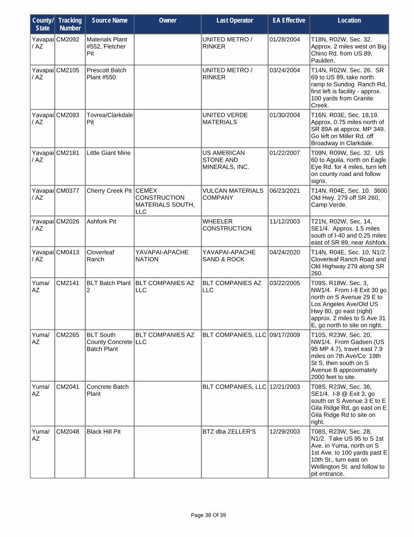
Page 38 Of 39
Yuma/ AZ
CM2048 Black Hill Pit BTZ dba ZELLER'S 12/29/2003 T08S, R23W, Sec. 28, N1/2. Take US 95 to S 1st Ave. in Yuma, north on S 1st Ave. to 100 yards past E 10th St., turn east on Wellington St. and follow to pit entrance.
Yavapai/ AZ
CM2093 Tovrea/Clarkdale Pit
UNITED VERDE MATERIALS
01/30/2004 T16N, R03E, Sec. 18,19. Approx. 0.75 miles north of SR 89A at approx. MP 349. Go left on Miller Rd. off Broadway in Clarkdale.
Yavapai/ AZ
CM2181 Little Giant Mine US AMERICAN STONE AND MINERALS, INC.
01/22/2007 T09N, R09W, Sec. 32. US 60 to Aguila, north on Eagle Eye Rd. for 4 miles, turn left on county road and follow signs.
Yavapai/ AZ
CM2105 Prescott Batch Plant #550
UNITED METRO / RINKER
03/24/2004 T14N, R02W, Sec. 26. SR 69 to US 89, take north ramp to Sundog Ranch Rd, first left is facility - approx. 100 yards from Granite Creek.
Yuma/ AZ
CM2041 Concrete Batch Plant
BLT COMPANIES, LLC 12/21/2003 T08S, R23W, Sec. 36, SE1/4. I-8 @ Exit 3, go south on S Avenue 3 E to E Gila Ridge Rd, go east on E Gila Ridge Rd to site on right.
Yavapai/ AZ
CM2092 Materials Plant #552, Fletcher Pit
UNITED METRO / RINKER
01/28/2004 T18N, R02W, Sec. 32. Approx. 2 miles west on Big Chino Rd. from US 89, Paulden.
Yuma/ AZ
CM2141 BLT Batch Plant 2
BLT COMPANIES AZ LLC
BLT COMPANIES AZ LLC
03/22/2005 T09S, R18W, Sec. 3, NW1/4. From I-8 Exit 30 go north on S Avenue 29 E to Los Angeles Ave/Old US Hwy 80, go east (right) approx. 2 miles to S Ave 31 E, go north to site on right.
Yuma/ AZ
CM2265 BLT South County Concrete Batch Plant
BLT COMPANIES AZ LLC
BLT COMPANIES, LLC 09/17/2009 T10S, R23W, Sec. 20, NW1/4. From Gadsen (US 95 MP 4.7), travel east 7.9 miles on 7th Ave/Co. 19th St S, then south on S Avenue B approximately 2000 feet to site.
Yavapai/ AZ
CM0413 Cloverleaf Ranch
YAVAPAI-APACHE NATION
YAVAPAI-APACHE SAND & ROCK
04/24/2020 T14N, R04E, Sec. 10, N1/2. Cloverleaf Ranch Road and Old Highway 279 along SR 260.
Yavapai/ AZ
CM0377 Cherry Creek Pit CEMEX CONSTRUCTION MATERIALS SOUTH, LLC
VULCAN MATERIALS COMPANY
06/23/2021 T14N, R04E, Sec. 10. 3600 Old Hwy. 279 off SR 260, Camp Verde.
Yavapai/ AZ
CM2026 Ashfork Pit WHEELER CONSTRUCTION
11/12/2003 T21N, R02W, Sec. 14, SE1/4. Approx. 1.5 miles south of I-40 and 0.25 miles east of SR 89, near Ashfork.
County/ State
Tracking Number
Source Name Owner Last Operator EA Effective Location

Page 39 Of 39
Yuma/ AZ
CM0437 CM0437 Section 9 Expansion
BLT COMPANIES, LLC GREY MOUNTAIN CONSTRUCTION LLC
03/03/2017 T08S, R21W, Sec. 9. Take I-8 Exit 7 (Araby Rd) north to US 95, then east on US 95 to approx. MP 37.7, then east on Butterfield Stage to site.
Yuma/ AZ
CM2352 Valley Sand & Gravel
LEBRECHT FAMILY TRUST
VALLEY SAND & GRAVEL
10/28/2014 T08S, R23W, Sec. 25, SW1/4. Site is located east of Yuma along US 95 (East County 9th Street) just east of S Avenue 3 E @ approximate MP 26.
Yuma/ AZ
CM2334 Dateland Pit #2 T & U INVESTMENTS, LLC
T & U INVESTMENTS, LLC
05/01/2013 T07S, R12W, Sec. 20,29,33. I-8 Exit 67 south to Old Highway 80, then east to South Avenue 66E, then south approx 1.8 miles on South Avenue 66E to site.
Yuma/ AZ
CM0434 Plant 80611 TANNER COMPANIES / RINKER
06/05/2003 T10S, R23W, Sec. 26. From I-8 Exit 3 (MP 4) go south approx 10.7 miles on S Avenue 3 E past E County 19th St. Haul road to site is on the right.
Yuma/ AZ
CM0040 Plant 80111 TANNER COMPANIES / RINKER
10/13/2000 T08S, R21W, Sec. 9,16. 13 miles east of Yuma at MP 37 on US 95.
Yuma/ AZ
CM0329 Roll 2 Pit DESERT ROAD BUILDERS, INC.
10/08/2002 T08S, R17W, Sec. 6, SW1/4. I-8 Exit 37, north on S Ave 36E, go right on old US 80, go left on S Ave 38E, go 4 miles and turn left on E County 5th St, go 3.5 miles to entrance.
Yuma/ AZ
CM2293 Fortuna Wash Material Source
H&S DEVELOPMENT, INC
FOOTHILLS SAND & GRAVEL
04/06/2011 T09S, R21W, Sec. 2, SE1/4. I-8 Exit14, (S Ave.13 E/S Foothills Blvd), go north to Frontage Rd. then east approx. 1.5 mi. to S Ave 14 1/2E, go north on S Ave 14 1/2E to site.
Yuma/ AZ
CM0395 South Yuma Pit DESERT ROAD BUILDERS, INC.
DESERT ROAD BUILDERS, INC.
04/30/2001 T10S, R23W, Sec. 24, NE1/4. From I-8 (Exit 3) S Avenue 3E, go south toE County 19th, left on E County 19th, travel approx.1 mile to site - on right-hand side.
Yuma/ AZ
CM2083 Cullison Materials Source
FNF CONSTRUCTION INC.
01/09/2004 T08S, R18W, Sec. 16, NE1/4. I-10 @ Exit 30 go north on Avenue 29E, 2.1 miles to E County 9th St, go east to S Ave 30E, go north until road ends, go northeast to site on left.
Yuma/ AZ
CM2329 Dateland Pit #1 RESOURCE CAPITAL GROUP LLC
FISHER SAND & GRAVEL
11/12/2019 T06S, R13W, Sec. 35, SE1/4. I-8 to Dateland, exit 67 (64E), go north approx. 4 miles on Ave 64E to N. Co. 3rd Street, then west 1 mile to site.
County/ State
Tracking Number
Source Name Owner Last Operator EA Effective Location