Master Erasmus Mundus em QUATERNARIO E PRÉ-HISTÓRIA...
138
Instituto Politécnico de Tomar – Universidade de Trás-os-Montes e Alto Douro (Departamento de Geologia da UTAD – Departamento de Território, Arqueologia e Património do IPT) Master Erasmus Mundus em QUATERNARIO E PRÉ-HISTÓRIA Dissertação final: Terminal Pleistocene Lithic Technology and Adaptation from Bulbula River B1s4 Site, Ziway-Shala Basin, Ethiopia Abebe Mengistu Taffere Orientadores: David Pleurdeau (PhD) Clément Ménard Steven A. Brandt (PhD) Júri: Marta Arzarello, Carlo Peretto, Jose Martinho Lourenço, Silverio Figueiredo, Gema Chachon, Antony Borel, François Semah, Carlos Lorenzo, Robert Sala Ano académico 2014/215
Transcript of Master Erasmus Mundus em QUATERNARIO E PRÉ-HISTÓRIA...

Instituto Politécnico de Tomar – Universidade de Trás-os-Montes e Alto Douro (Departamento de Geologia da UTAD – Departamento de Território, Arqueologia e Património do IPT)
Master Erasmus Mundus em
QUATERNARIO E PRÉ-HISTÓRIA
Dissertação final:
Terminal Pleistocene Lithic Technology and Adaptation from
Bulbula River B1s4 Site, Ziway-Shala Basin, Ethiopia
Abebe Mengistu Taffere
Orientadores: David Pleurdeau (PhD) Clément Ménard Steven A. Brandt (PhD)
Júri: Marta Arzarello, Carlo Peretto, Jose Martinho Lourenço, Silverio Figueiredo, Gema Chachon, Antony Borel, François Semah, Carlos Lorenzo, Robert Sala
Ano académico 2014/215

II""
Abstract
Archaeological excavation which had been conducted in 2009 and 2010 in the Ziway-
Shala Basin, close to the Bulbula River Canyon at B1s4 site, has yielded lithic assemblages and
few faunal remains. Two human occupation horizons (PS1 and PS2) were identified which are
separated by an occupational hiatus at the very end of the terminal Pleistocene. Analysis of
debitage on both unit levels indicates the presence of similar features that lead us to assume that
B1s4 lithic industry was oriented towards the production of blades and bladelets. But, this site
shows strong technological and industrial variabilities to early Holocene sites which are very
close to B1S4. The microliths, which are widely discovered at early Holocene sites-and to a
lesser extent sites dated to Pre-Maximum Glacial Maximum-are hard to find at B1s4.Alike
Paleoenviromental records in the Ziway-Shala basin and other parts of Ethiopia and Eastern
Africa, B1s4 has proved that terminal Pleistocene was characterized by fluctuating weathering
conditions that might have forced hunter-gatherers in the region to practice diverse adaptive
strategies.

III""
Acknowledgments
First I would like to take this opportunity to thank my supervisor Clément Ménard,
Université Toulouse Jean Jaurè, France, for his valuable suggestions, constructive comments,
and unreserved guidance and direction for the overall enrichment of this thesis. I am also greatly
indebted to my supervisor, Dr. David Pleurdeau, Museum National D'histoire Naturelle de Paris,
France, who significantly supporting and facilitating this research since the beginning of this
project. I am also sincerely grateful to my co-supervisor Dr. Steven A. Brandt, University of
Florida, USA, who was also responsible in supporting this research by providing assistance and
alternative views during the analysis of the materials.
I wish to thank also the European Union’s Erasmus Mundus program who providing the
funding support for my study and research. I would like also to thank my professors and staff
members who work in Prehistoric Art Museum of Mação, Instituto Politecnico de Tomar,
Universidade de Tras-os-montes e Alto Douro and Universita' Degli Studi di Ferrara for their
advice and support providing to me during my two years of Stay.
I am also very grateful to Late Stone Age Research Project in Ethiopia Directors, Dr.
François Bon (Université Toulouse Jean Jaurè, France) and Asameraw Dessie (Authority for
Research and Conservation of Cultural Heritage /ARCCH), Ethiopia) for granting me a permit to
study their lithic materials from Bulbula B1s4 site. I would like also to thank ARCCH which
provided me a laboratory room during the analysis of the lithic materials. My thanks also go to
Elizabeth Peterson (University of Simon Fraser, Canada) for her support to analyze the scrapers
from B1s4 and also for Dr. Joséphine Lesur (Museum National D'histoire Naturelle de Paris,
France) who provided the data of faunal remains. Last, not least, I am deeply indebted to my
friend, Aldo Malagó for his unreserved assistance and advice that he did to me for the last two
years.

IV"""
Table of Contents
Chapter One----------------------------------------------------------------------------------------- 1
Introduction and Research Objectives ----------------------------------------------------------- 1
1.1.Background----------------------------------------------------------------------------- --------- 1
1.2.Research Objective --------------------------------------------------------------------------- 2
1.3.The significance of the study ---------------------------------------------------------------- 3
1.4.Statement of the Problem -------------------------------------------------------------------- 3
1.5.Development of the Research Interest and the selection of the study site--------------- 4
1.6.Research Methods----------------------------------------------------------------------------- 5
1.6.1.! Data Analysis------------------------------------------------------------------------------ 5
1.6.2.! Debitage Analysis-------------------------------------------------------------------------- 7
1.6.3.! Core Analysis------------------------------------------------------------------------------ 8
1.6.4.! Tool Analysis------------------------------------------------------------------------------ 8
1.6.5.! Exploratory analysis---------------------------------------------------------------------- 9
1.6.6.! Use Wear Analysis------------------------------------------------------------------------ 9
1.7. Definitions Retained for this Study--------------------------------------------------------- 10
1.7.1.! Artifact Typology-------------------------------------------------------------------------- 10
1.7.2.! Completeness ----------------------------------------------------------------------------- 10
1.7.3.! Length, Width, and Thickness ----------------------------------------------------------- 10
1.7.4.! Dorsal Scar Pattern and Scar Counts----------------------------------------------------- 11
1.7.5.! Presence or Absence of Cortex ---------------------------------------------------------- 11
Chapter two----------------------------------------------------------------------------------------- 12
Cultural and Environmental Background-------------------------------------------------------- 12
2.1.Contextual Data-------------------------------------------------------------------------------- 12
2.1.1.! Features of the Ziway-Shala basin, Main Ethiopian Rift------------------------------ 12
2.1.1.1.Geology and Geomorphology of Bulbula River------------------------------------ 15
2.1.1.2.Climate and Vegetation of the Ziway-Shala Basin-------------------------------- 22
2.2.Archaeological and Historical Background Bulbula----------------------------------- 22
2.3.Stratigraphy of the Bulbula River-------------------------------------------------------- 26
2.4.Cultural and Chronological Sequence of LSA Industries in Eastern Africa--------- 34
2.5.Adaptation and subsistence Strategies of Late Stone Age Hunter-Gatherers------- 41

V"""
2.6.LSA Raw Material Exploitation and Socio-Territorial Organization Pattern------- 43
2.7.Characteristic Feature of Blades and Bladelets and their
Production Techniques------------------------------------------------------------------- 45
Chapter Three-------------------------------------------------------------------------------------- 48
Literature Review---------------------------------------------------------------------------------- 48
3.1. Previous Research on Late Pleistocene LSA----------------------------------------------- 48
3.1.1. Late Pleistocene LSA sites in East Africa------------------------------------------------ 48
3.1.2. Previous Research on Late Pleistocene LSA sites in Ethiopia------------------------- 48
3.2. Brief Review Late Pleistocene Paleoenvironment in East and
the Horn of Africa---------------------------------------------------------------------------- 56
3.2.1. Paleoenvironment of East African Late Upper Pleistocene---------------------------- 56
3.2.2. Paleoenvironment of Ethiopian Late Upper Pleistocene ------------------------------ 58
3.2.2.1. Lower Omo Basin------------------------------------------------------------------------- 59
3.2.2.2. Central and northern Afar-------------------------------------------------------------- 59
3.2.2.3. Besaka------------------------------------------------------------------------------------- 60
3.2.2.4. K’one Crater Complex/Garibaldi Caldera Complex---------------------------------- 61
3.2.2.5. Aladi Spring------------------------------------------------------------------------------- 62
3.2.2.6. Paleoenvironment of the Ziway-Shala Basin during the Terminal
Pleistocene------------------------------------------------------------------------------------ -------- 62
Chapter Four---------------------------------------------------------------------------------- -------- 67
Lithic Analysis-------------------------------------------------------------------------------- -------- 67
4.1. General Presentation-------------------------------------------------------------------------- 67
4.2.Faunal Remains--------------------------------------------------------------------------- -------- 67
4.3. Presentation of Lithic Assemblage--------------------------------------------------------- 69
4.3.1. Raw Material Acquisition----------------------------------------------------------------- 69
4.3.2. Raw material Condition-------------------------------------------------------------------- 70
4.3.3. Dorsal Scar Pattern and Number of Flake Scars----------------------------------------- 71
4.3.4. Striking Platforms-------------------------------------------------------------------------- 74
4.3.5. Debitage Assemblage Analysis ---------------------------------------------------------- 75
4.3.5.1. Cores--------------------------------------------------------------------------------------- 77
4.3.5.2. Flake and Flake Fragments ------------------------------------------------------------ 80

VI"""
4.3.5.3. Blades and Blade fragments------------------------------------------------------- --------- 82
4.3.5.4. Bladelets and bladelet fragments---------------------------------------------- --------- 84
4.3.5.5. Chips and shattered pieces--------------------------------------------------- -------- 85
4.3.6. Tools------------------------------------------------------------------------------------ --------- 86
4.3.6.1. Scrapers (N=14) --------------------------------------------------------------- --------- 88
4.3.6.2. Use Wear Study of Scrapers-------------------------------------------------- --------- 90
4.3.6.3. Burins---------------------------------------------------------------------------- --------- 93
4.3.6.4. Other shaped tools-------------------------------------------------------------- --------- 93
4.3.6.5. Utilized tools-------------------------------------------------------------------- --------- 97
Chapter Five------------------------------------------------------------------------------ --------- 99
Discussion and Conclusion-------------------------------------------------------------- --------- 99
5.1. Lithic reduction sequence analysis------------------------------------------------ --------- 99
5.1.1. Raw material procurement and site function --------------------------------- -------- 99
5.1.2. Reduction Sequence-------------------------------------------------------------- --------- 102
5.2. Cultural affinities and chronological place of B1s4 within
local and regional LSA framework--------------------------------------------------- --------- 103
5.2.1. Cultural tradition and chronological sequence-------------------------------- --------- 103
5.2.2. Environmental and cultural comparisons ---------------------------------- -------- 105
5.3. Conclusion-------------------------------------------------------------------------- --------- 110
Appendix--------------------------------------------------------------------------------- --------- 112
Bibliography---------------------------------------------------------------------------------- --------- 118

VII""
List of Figures
Figure 1: location of study area (B1s4) ---------------------------------------------- -- --------- 13"
Figure 2: satellite image (Landsat) of the Ziway-Shala basin-------------------------- --------- 14"
Figure 3: simplified geologic map of the study area (Ziway-Shala basin)----------- --------- 16"
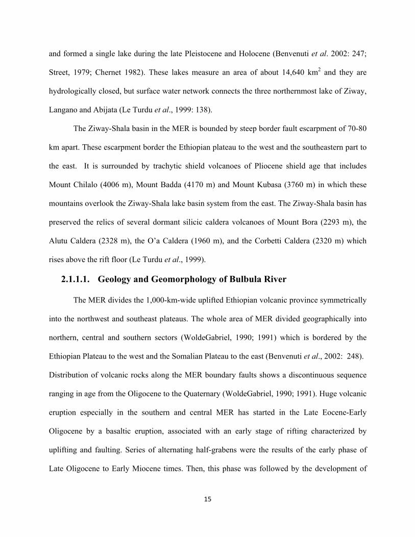
Figure 4: Fluvio-lacustrine sediment, east of Lake Shala ------------------------------ --------- 18
Figure 5: Pumice deposit, northeast of Lake Ziway------------------------------------- -------- 19
Figure 6: synthesis of the main geomorphological features in Ziway-Shala------ --------- 21"
Figure 7: Main paleoanthopological sites and geographic features-------------------- -------- 23
Figure 8: areas investigated by the LSA Sequence in Ethiopia ----------------------- -------- 25"
Figure 9: schematic cross-section along Bulbula River (Ziway-Shala Basin)---- ---------- 28
Figure 10: Geological log of the sedimentary formations in Bulbula----------------- -------- 30
Figure 11: Radiocarbon dates of archaeological sites in Bulbula---------------------- --------- 31"
Figure 12: view of B1s4 at the end of excavation in 2010------------------------------ -------- 33
Figure 13: Location major LSA sites in Eastern Africa-------------------------------- --------- 37"
Figure 14: Artifacts covered in patina---------------------------------------------------- -------- 71
Figure 15: graph shows classes of main debitage from B1s4-------------------------- -------- 77
Figure 16: the various core types--------------------------------------------------------- -------- 79"
Figure 17: selected blades blanks ------------------------------------------------------- --------- 83
Figure 18: Long and thing bladelets blanks---------------------------------------------- -------- 84
Figure 19: scrapers drawing illustration------------------------------------- ------------ --------- 89"
Figure 20: Bulbula scraper showing scraping wear ------------------------------------- --------- 91"
Figure 21: Experimental tool used in a cutting motion--------------------- ------------ --------- 92
Figure 22: the graphs represent the frequency of different tool forms---------------- --------- 94
Figure 23: Straight backed pieces from B1s4, bulbula---------------------------------- --------- 95

VIII""
Figure: 24: photo illustration of utilized broken blade fragments----------------- --------- 98
IX""
Lists of Table
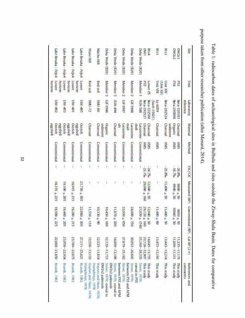
Table 1: radiocarbon dates of archaeological sites in Bulbula
and sites outside the Ziway-Shala Basin. Dates for comparative-------------------- -------- 32
Table 2: total number of identified and unidentified faunal remains of B1s4)------ --------- 68
Table 3: the identified dorsal scar patterns --------------------------------------------- --------- 72
Table 4: inventory butt types from B1s4------------------------------------------------- --------- 74
Table 5: descriptive analysis of different debitage classes ----------------------------------- 76"
Table 6: inventory of platform types and core blank types----------------------------- --------- 78
Table 7: inventory of Flakes as whole flakes and fragments--------------------------- -------- 81
Table 8: inventory of various tool classes from B1S4----------------------------------- --------- 87
Table 9: different classes of scraper ------------------------------------------------------ --------- 88
Table 10: use wear hardness scale revised ----------------------------------------------- --------- 90
Table 10: Descriptive statistics of burin------------------------------------------------- -------- 93
Table 12: Descriptive statistics of microliths, notches and backed pieces------------------- 96
"
1""
Chapter One
Introduction and Research Objectives
1.1.! Background
The archaeological survey and excavation which had been conducted by Late Stone Age
Research Project in Ethiopia from 2007 -2010 had revealed human occupation horizons at
Bulbula which were dated to early Holocene, Terminal and early Pleistocene period (Bon et al.,
2013). The study site, B1s4, from Bulbula 1 locality is part of this project and it was first
discovered in 2008. Charcoal sample from the lower paleosol (PS1) level of B1s4 were taken for
radiocarbon dating and dated to 12,040 ± 50 (14,045-13,755 cal BP) using AMS dating.
Therefore, the earliest occupation at B1s4 site is belongs to the Late Stone Age, particularly for
the Terminal Pleistocene period (Ménard et al., 2014) which was characterized by fluctuating
climate conditions such as an increasing temperature and moisture, but it was mainly interrupted
by an abrupt return to the arid condition and probably Younger Dryas climatic reversal (Kiage
and Liu, 2006: 644). This fluctuating climatic condition during the terminal Pleistocene
increasingly modified the cultural and subsistence strategies of the hunter-gatherers.
Chronologically, the terminal phase of the last glaciation in East Africa had prevailed after
12,500 BP and had continued into the onset of the Holocene (Kiage and Liu, 2006: 644).
Moreover, during this period the cultural and environmental interaction and contact of
hunter-gathers is a focus of many archaeological researchers in the field who are interested to
understand human adaption. During this period, hunter-gathers may have been forced to design
certain adaptive strategies to cope up with the changing environment which finally brought
district lithic technology in some regions (e.g. South Africa) (Ambrose, 2002: 12:13).

2""
Therefore, my thesis project focused on the analysis Terminal Pleistocene lithic materials from
B1s4 site which had been excavated and collected by the project of Late Stone Age Sequence in
Ethiopia directed by François Bon (Université de Toulouse, France) and Asamerew Dessie
(ARCCH, Ethiopia).
1.2.! Research Objective
The main objective of this research was to understand technological adaptation of B1s4 Bulbula
hunter-gatherers to the major resources and environmental changes that took place during the
Terminal Pleistocene. The specific objectives of this research are the following:
1.! To understand characteristic features LSA lithic technology at B1s4 and how Terminal
Pleistocene hunter-gatherers at B1s4 organized and used the surrounding landscape
during this period;
2.! To investigate how the cores were exploited during the manufacture of flakes;
3.! To understand the subsistence strategy of hunter-gatherers of B1s4 based on evidence
found on lithic and faunal remains;
4.! To understand technological and typological traditions as well as behavioral and social
changes that prevalent during the end of the Pleistocene and the onset of the Holocene at
Bulbula (B1s4);
5.! To compare and contrast the typological and technological features of Bulbula B1s4 lithic
assemblage from local and regional site such as B1S4, DW2S1, DW2S2 at Bulbula and
FEJx2 at Lake Besaka and others;
6.! To understand better late quaternary archaeology and paleoenvironment of the study area.

3""
1.3.! The significance of the study
The terminal Pleistocene, which is characterized by fluctuating and turbulent climatic conditions,
has been the concern of archaeologists who have been working on this period. In Ethiopia, this
period spans from c. 18,000-12,000 BP and culturally has been understood by few stone artifacts
uncovered from Lake Besaka (Brandt, 1982) and Bulbula B1s1 (Ménard et al., 2014; Habte,
2014). Yet, there is a lack of data to understand the technological aspect, subsistence strategy and
adaptation behavioral aspect of hunter-gatherers who were living during this terminal Pleistocene
period. So, this thesis would generate additional data which are useful for understanding
paleoenvironment, cultural behavior and economic subsistence of hunter-gathers of the terminal
Pleistocene period.
1.4.! Statement of the Problem
Despite several attempts had been made to establish the chronology and techno-typology
pattern of LSA industry of the Horn of Africa, yet this period remains poorly understood. There
is no general consensus about the definition and the chronological boundaries among the
researchers working in the region. It is ‘catch-all concept’ which depends on different kind of
contexts and industries dated between MIS3 and Late Holocene (Ménard et al., 2014).
Researchers such as Brandt (1982) characterized LSA dominantly by the existence of backed
microlithic tools and blade-core technology. Others said that LSA culture is apparent by the
production of blade and miniaturization (Ménard et al, 201. All agree that archaeological reality
is much more complex, and widely accepted that the existing archaeological data is not sufficient
enough for understanding hunter-gatherers technological behavior in the region because the
temporal and technological changes that occurred during this period were limited by lack of
stratigraphic sequence and reliable radiocarbon data (Brandt, 1982).

4""
Despite several research projects has been conducted in order to establish the chronology
and typology of LSA in the Horn of Africa, the available data did not produce enough
information and yet this period remains poorly understood. Hence, in order to generate more data
useful for understanding the chronology and the nature of technological and environmental
changes in the LSA period in general and the Terminal Pleistocene in particular, more data are
needed sites like Bulbula. Therefore, the data from Bulbula (B1s4) has the potential to yield
important information to understand Terminal Pleistocene hunter/gatherers cultural development
in the Ziway-Shala basin, which is located in the Main Ethiopian Rift. My research project
therefore focused to understand the adaptive strategies of the Terminal Pleistocene hunter-
gathers in Bulbula (B1s4) through close examination of the technological innovation, land use
and mobility pattern, and subsistence strategies.
1.5.! Development of the Research Interest and the selection of the study site
My research interest on the study of lithics developed in 2013 when I have started to
work on analysis of lithic materials collected from Mezber by Eastern Tigray archaeological
Project (ETAP) near to Adigrat town. The reason for selecting B1s4 for study is related to the
importance of the site for yielding information about the technological and behavioral
adaptations of the hunter-gathers of the Terminal Pleistocene period as the areas is preserved
important water bodies of the Ziway-Shala basin that may provide resources during the bottle
neck period faced the Last Glacial Maximum hunter-gathers. In addition, the B1s4 has preserved
important sedimentary formations of two paleosols in which one of it was securely dated and
could provide data to answer hunter-gather adaptive strategies of the new environment they
encounter during the Terminal Pleistocene and also it offers me an opportunity to compare to

5""
other post-LGM site of Bulbula like B1S1 studied by Habtie (2013)and DW2S1 and DW2S2
(Ménard et al. (2014).
1.6.! Research Methods
1.6.1.!Data Analysis
During classifying and analyzing lithic artifacts, researchers employ different approaches
and often determine the methodologies based on the type of question they would like to address.
According to Vanpool and Leonard (2011), both qualitative and quantitative methods are
important for the analysis of lithic assemblage. The qualitative and theoretical perspective tells
us which observations are important to make and how explanations are constructed. On the other
hand, quantitative methods and statistical techniques play an important role in archaeological
analysis because archaeologists rely on heavily on fragmentary archaeological samples that time
and the vagaries of environment (including human activities) allowed to be preserved. These
quantitative methods and statistics were employed for data analysis which were collected by
systematic observation and analysis of the lithic assemblages. Bearing this in mind, the lithics
assemblages derived from B1s4 were analyzed using both qualitative and quantitative
methodological approach.
Qualitative data analysis would be organized using the lithic assemblages uncovered
during excavation as well as referring the draft notes taken during the field work. In order to
develop standard classification system, first levelled the artifacts on the table at the laboratory
room available by Authority for Research and Conservation of Cultural Heritage (ARCCH).
This would be useful for me to be apparent for the different form of tools variability and for the
first few days I tried various classification schemes with different analytical procedures until I
came up with the classification scheme and a standard descriptive system that would be capable

6""
of dealing with the observed variability, yet would be easy to understand and relatively fast to
record.
The analysis of lithics begins with the identification and classification of lithic
assemblages. Classification plays a great role for the summarization of data for descriptive
purpose. It plays also a role as a heuristic device (Andrefsky, 2005). According to Whittaker
(1994:270), there are four factors that govern the shapes of the lithic artifacts. These factors
include 1) the raw material of which the tools are manufactured, 2) the technology employed
during the production of the artifacts, 3) the function or purpose of the artifacts, and 4) the style
of characteristic mode of tool form current among the people making the object. During the
analysis of B1s4 lithic assemblages, the raw material choice and the technological employed
were systematically examined and used to develop a classification scheme for my data analysis
(based on both qualitative and quantitative method) as well as to achieve my research goals. The
prehistoric hunter-gathers from B1s4 were totally produced their lithic artifacts from obsidian
which are available near to the site. In addition, the techniques applied and the technologies
practiced at B1s4 were traced by analyzing individual debitages, cores and tools. The stage of
manufacture and the manufacturing techniques exhibited on each artifact provide evidences to
understand the technology employed during the production of artifacts. So, taking in account
this, individual lithic artifacts from B1s4 would be carefully classified and examined in order to
determine an artifact was as cores, tools and debitages in one hand and to reconstruct the
technical and technological procedures of a given assemblages on the other hand. For debitage
analysis, decortications of debitage analysis, tool debitage analysis, and hierarchical analysis
were employed. To understand core reduction sequence, both core and flake assemblages were
analyzed.

7""
1.6.2.!Debitage Analysis
Most prehistorians who study lithics have given much attention for cores and tools
relatively compared to flakes and debris, collectively they are called debitage, during the
classification and the analysis of lithic assemblages (Fish, 1981: 374). Debitage are flaked
products removed by either pressure or percussion techniques. They tell the whole process which
includes wide variety of activities and varies stages of process of the raw material from the
original to the finished stages (Inizan et al 1999; Fish, 1981: 374). The analysis of debitage can
be differed from one to another depending on the purpose of lithic studies (Gang, 1997). But,
whatever such variations exists among researchers, the methods of debitage analysis can be
largely divided in to two classes: individual flake analysis and flake aggregate analysis
(Anderfsky, 2005; Ahler 1989:86 cited in Gang, 1997: 89). The individual flake analysis
comprises decortication or core reduction debitage analysis, tool debitage analysis and
hierarchical analysis (Gang 1989:89).
During the analysis of B1s4 lithic artifacts, I used individual methods of debitage analysis
particularly for whole flakes, blades, bladelets, cores and tools. On the other hand, angular
wastes, broken flakes, chips and shatters were analyzed in aggregate or mass analysis system.
According to Gang (1989: 106), during mass or aggregate analysis, individual artifacts are not
investigated, instead this debitage analysis method favors counting and weighting of the total
artifacts in a given artifact sample. For individual debitage analysis, the basic and common
debitage attributes such as the size and shape of every whole flakes (maximum length, width and
thickness), artifact type, platform type, cross-section, the presence or absence of cortex, nature of
retouch (for scrapers), completeness and physical condition were considered. Then based on
these attributes, an attribute table on excel program was prepared and data entered into the

8""
computer. The same attribute analysis table is used for tools and cores. This attribute table is
adopted and modified from Brandt (1982; 2012).
1.6.3.!Core Analysis
Researchers employ different methodological approach for core analysis. Morphological
description, technological analysis or graphical representations of technological attributes are
some of the methodological approaches often used by researchers. These methodological
approaches of core analysis provide information about temporal relationships between flake
removals. It also offers spatial information and gives information useful to know different stages
of reduction sequence and movement of abandonment of reduction process.
Specific core industries such as blade and bladelet constitute a small part of the lithic
assemblage of B1s4 and in order to understand reduction sequence of the assemblage, all of these
cores were analyzed from morphological and technological point of view. Experimental
archaeology has provided useful data for the understanding of reduction sequence of cores. In
their early stage, cores are mostly characterized by large and heavy features and exhibit few scars
on the major removal face and simple scar pattern. When it reaches at middle stage, both core
size and removal surface area on cores reduced. At this stage, the negative features of the core
manifests complex features both in terms of scar count and pattern which resulted from the
previous scar pattern. In final and latter stage, reduction of core often characterized by
amorphous shape and very complex scar pattern and high scar counts (Baumler 1987:27;
Munday, 1976:120 cited in Gang, 1989).
1.6.4.!Tool Analysis
According to Anderfsky (2005: 76), tools “are considered to be all those chipped stone
objective pieces that have been modified by intentionally altering their form and those detached

9""
pieces that show signs of modification as a result of use”. Tools can be identified either by the
task for which it was produced or the type of choice made by the makers among several equally
valid and feasible options. The task of every tool is measured by its functional attributes, but the
type of choice of the material is related to stylistic attributes. For this thesis, the lithic assemblage
from B1s4 is investigated by dividing into shaped and unshaped tools. Shaped tools comprise
scrapers, retouched flakes, backed pieces, while unshaped tools include irregular modified pieces
and lithics with utilized edge.
1.6.5.!Exploratory analysis
Further analytical tools would be employed and the data on the attribute table were
represented visually using for example frequency distributions like histogram, bar chart, pie chart
etc. Then, the data summarized in the graphical representation were again further described by
using numerical form of descriptive statistics which can be based on a single variable. This
numerical characterization of the data allows a more formal means of both describing a
distribution and comparing two or more distribution. These numerical descriptions of distribution
are termed either statistics or parameters depending on whether they describe a population or a
sample. Statistics are descriptions of the characteristics of a statistical sample, whereas
parameters refer to the characteristics of statistical population Vanpool and Leonard (2011).
1.6.6.!Use Wear Analysis
Use wear analysis is the study of the function of tools based on the complex analysis of
all traces of use, including macro-deformations, micro-linear traces and polishes (Peterson,
2015). This study can be investigated by using both low-power or high-power microscope
technique. By the request of the author of this thesis, a small use wear study was conducted by
Elizabeth Peterson (PhD candidate from Simon Frazer University, Canada), up on a selection of
10""
14 shaped obsidian tools classified as different types of scrapers from B1s4. According to here
report, the method used within the analysis is the standard low-power use wear method
developed by Dr. George Odell (1977). Before evaluation, each stone was washed carefully in
water and then lightly bathed in 50% acetone to clear away any hand grease that could be
confused as polish under microscopic inspection. The tools were then each evaluated under a
stereomicroscope of 6 to 80X magnification, tracking the location, type, and frequency of the
different wear attributes.
1.7.! Definitions Retained for this Study
1.7.1.!Artifact Typology
Artifact type is a subjective, macro-level assessment based on presence or absence of
specific features on each artifact (e.g. lateral retouch, butt morphology, and overall artifact
length, width, and thickness).
1.7.2.!Completeness
Completeness is determined based on whether or not the artifact was broken during use-
related activates or during production or post-depositional processes. When an artifact had a bulb
of percussion or unbroken proximal end, intact lateral edges, and intact distal tip or bit, it was
coded as complete. Other codes, for example, like proximal flake and distal flake fragment were
used if the artifact had an intact proximal end and lateral edges and distal end and lateral edge
respectively.
1.7.3.!Length, Width, and Thickness
Length, Width, and Thickness was recorded in millimeters (mm) and measured
maximum limits of each artifact. Each artifact was held perpendicular then parallel during the

11""
measuring process. Measurements were recorded with one electronic digital caliper that
measures to the hundredth of a millimeter (0.00 mm).
1.7.4.!Presence or Absence of Cortex
Cortex was measured only viewing the dorsal surface of the artifact and was recorded
either the presence or absence of cortex.
1.7.5.!Dorsal Scar Pattern and Scar Counts
Dorsal scar patterns can indicate particular reduction sequences and illuminate standards
in production or reduction of stone tools. For example artifacts may have parallel or convergent
dorsal arrises indicating unidirectional core flaking. On the other hand scar counts are refer to the
number of flake scars evident on the on the dorsal face of the flake.

12""
Chapter two
Cultural and Environmental Background
2.1.Contextual Data
2.1.1.!Features of the Ziway-Shala basin, Main Ethiopian Rift
The Ziway-Shala basin is located in the Main Ethiopian Rift (hereafter called MER),
which is part of the northern extension of East African Rift System. Its northern limit extends to
the Red Sea and Gulf of Aden rift system (Gasse and Street, 1978: 280). The study area, B1s4, is
found in the Ziway-Shal Basin and it is located at 07°49.125’ N and 038°41.909’ E close to the
edge of Bulbula canyon and to the north of Bulbula 1 locality (figure 1 and figure 2) (Bon etal.,
2013). It is part of the Bulbula Plain which is situated between Lake Ziway and Lake Abijata and
extends 28 km in length and 10 km in width. This wider plain area varies in elevation ranging
between 1640 and 1700 m a.s.l. In the eastern and western part, the Bulbula plain is bounded by
Alutu volcano and, the Waso and Macho hills respectively (Di Paola, 1972).
13""
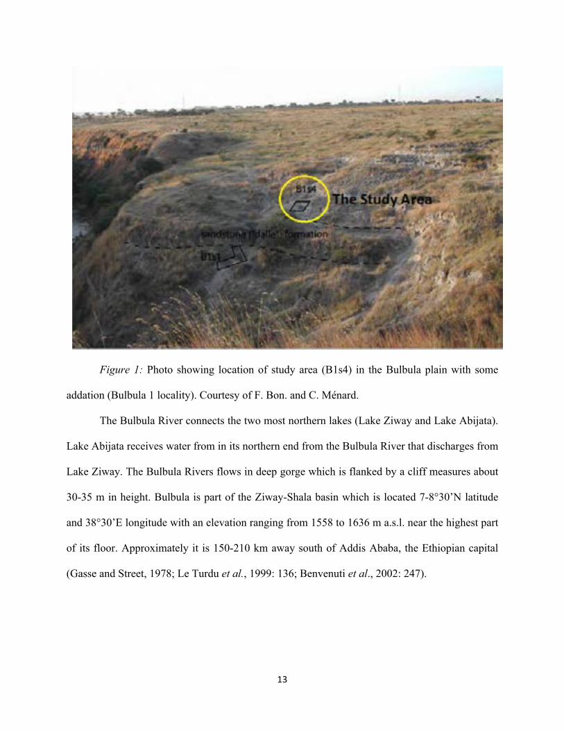
Figure 1: Photo showing location of study area (B1s4) in the Bulbula plain with some
addation (Bulbula 1 locality). Courtesy of F. Bon. and C. Ménard.
The Bulbula River connects the two most northern lakes (Lake Ziway and Lake Abijata).
Lake Abijata receives water from in its northern end from the Bulbula River that discharges from
Lake Ziway. The Bulbula Rivers flows in deep gorge which is flanked by a cliff measures about
30-35 m in height. Bulbula is part of the Ziway-Shala basin which is located 7-8°30’N latitude
and 38°30’E longitude with an elevation ranging from 1558 to 1636 m a.s.l. near the highest part
of its floor. Approximately it is 150-210 km away south of Addis Ababa, the Ethiopian capital
(Gasse and Street, 1978; Le Turdu et al., 1999: 136; Benvenuti et al., 2002: 247).

14""
Figure 2: satellite image (Landsat) of the Ziway-Shala basin showing the location of
main LSA sites (windmills) and sampled obsidian sources (blue dots) (after Ménard et al., 2014:
57).
As it has presented in figure 2, the Ziway-Shala basin comprises rift-bounded chains of
four different lakes (Ziway, Langano, Abijata and Shala) which were different times connected
15""
and formed a single lake during the late Pleistocene and Holocene (Benvenuti et al. 2002: 247;
Street, 1979; Chernet 1982). These lakes measure an area of about 14,640 km2 and they are
hydrologically closed, but surface water network connects the three northernmost lake of Ziway,
Langano and Abijata (Le Turdu et al., 1999: 138).
The Ziway-Shala basin in the MER is bounded by steep border fault escarpment of 70-80
km apart. These escarpment border the Ethiopian plateau to the west and the southeastern part to
the east. It is surrounded by trachytic shield volcanoes of Pliocene shield age that includes
Mount Chilalo (4006 m), Mount Badda (4170 m) and Mount Kubasa (3760 m) in which these
mountains overlook the Ziway-Shala lake basin system from the east. The Ziway-Shala basin has
preserved the relics of several dormant silicic caldera volcanoes of Mount Bora (2293 m), the
Alutu Caldera (2328 m), the O’a Caldera (1960 m), and the Corbetti Caldera (2320 m) which
rises above the rift floor (Le Turdu et al., 1999).
2.1.1.1.! Geology and Geomorphology of Bulbula River
The MER divides the 1,000-km-wide uplifted Ethiopian volcanic province symmetrically
into the northwest and southeast plateaus. The whole area of MER divided geographically into
northern, central and southern sectors (WoldeGabriel, 1990; 1991) which is bordered by the
Ethiopian Plateau to the west and the Somalian Plateau to the east (Benvenuti et al., 2002: 248).
Distribution of volcanic rocks along the MER boundary faults shows a discontinuous sequence
ranging in age from the Oligocene to the Quaternary (WoldeGabriel, 1990; 1991). Huge volcanic
eruption especially in the southern and central MER has started in the Late Eocene-Early
Oligocene by a basaltic eruption, associated with an early stage of rifting characterized by
uplifting and faulting. Series of alternating half-grabens were the results of the early phase of
Late Oligocene to Early Miocene times. Then, this phase was followed by the development of

16""
full symmetrical grabens and rift-in-rift structures (WoldeGabriel et al., 1990; Le Turdu et al.,
1999; Benvenuti et al., 2002).
"
Figure 3: simplified geologic map of the study area (Ziway-Shala basin) (after Rango,
2009: 35).

17""
The Ziway-Shala basin in the central sector of the MER was formed by the erupted
voluminous flow of rhyolitic ignimbrites and collapsed calderas during early Pliocene tectonic
event. This central sector of the MER and its shoulders are made of volcanites and pyroclastic
rocks, whereas large areas of the rift floor are covered by volcano-lacustrine and fluvio-
lacustrine deposits (WoldeGabriel et al., 1990). Compared to the previous periods, the Late
Pleistocene–Holocene time interval appears to be characterized by minor tectonic deformation.
During these periods, Wonji Fault Belt (WFB), which formed part of the central sector of MER
and eastern marginal graben of the Ziway-Shala basin, and the Silti Debre Zeit Fault Zone
(SDZFZ) were the two main areas in the sector of MER dominantly affected by tectonic and
volcanic events (Benvenuti et al., 2002). Volcanic activities continue from the Middle
Pleistocene to the present in WFB and are marked by the development of fluvio-lacustrine
basins. Successive Fluvio-lacustrine basins have been also formed in the Pleistocene-Holocene in
an extensive area of the MER floor (Le Turdu et al., 1999; Benvenuti et al., 2002). This was also
a time when joint history of sedimentation in the Ziway, Langano, Abijata and Shala lake basins
have started in the central MER (Le Turdu et al., 1999).
18""
Figure 4: Fluvio-lacustrine sediment, east of Lake Shala (after Rango, 2009:36)

19""
Figure 5: Pumice deposit, northeast of Lake Ziway (after Rango, 2009: 36)
Lacustrine sediments were formed by non-volcanic activities in portions of the rift. This
lacustrine formation in the portions of the rift valley covered a large area of about 4000km2 and
whose thickness is sometimes considered range from about 40 m in Bulbula River and 50 m in
Boru and Maky River up to more than 100 m between Modjo and Koka. These lacustrrine
sediments were formed when the big lakes were formed when lakes were filled with water
drying up in the area where in the past occupied the floor of the rift valley. Lakes Ziway,
Langano, Abijata and Shala in fact, are the remnants of the ancient large water basin. The
lacustrine deposits are marked by the presence of cemented volcanic sands, and ashes,
transported pumice, silt, clay and diatomites (Di Paola, 1972).

20""
The Late Pleistocene-Holocene deposits of the Ziway-Shala basin have revealed three
lithostratigraphic units. The first two, the alluvial and fluvio-lacustrine deposits, formed the
lithostratigraphic unit of Meki Formation. Evidence of this formation is recorded on the
fluctuation marks identifying in the Meki River base-level (Benvenuti et al., 2002). The other
lithostratigraphic unit, which is called Bulbula Formation, was recorded in the Ziway-Shala
Basin. Lacustrine diatomaceous marls and calcareous sands formed this lithostratigraphic unit.
This formation is dominated by a thick (about 30 m) volcaniclastic Latest Pleistocene unit which
preserves erosive surfaces and paleosols used as reference for the transition from Upper
Pleistocene to Holocene deposits (Gasse and Street, 1978). The last stratigraphic unit is called
the Ajewa Formation which is comprised the eastern shore of Lake Shala. This unit is composed
of Late Pleistocene and Holocene deep to shallow lucustrine, shoreface, alluvial and colluvial
deposits (Benvenuti et al., 2002).
With regards to geomorphology, striking geomorphological evidences of lake
fluctuations and soil formation process have been identified in the Ziway-Shala basins in a form
lacustrine recessional still stands, such as terraces and stranded plaeo-shorelines (figure 6).
Evidences of lucustrine terraces (V-I from higher to lower) are recognized around Lake Ziway
(Benvenuti et al., 2002). Relict shorelines were also identified and they are mainly developed in
the southern basin of the MER. Evidences of terraces has continued to develop during the early
phases of the Holocene and a single lake had existed during the development of terrace IV dated
between 9600 and 9400 BP, with a subsequent flooding at about 5400-5100 BP (Benvenuti et al.,
2002).

21""
Figure 6: synthesis of the main geomorphological features related to Late Quaternary
lake fluctuations (after Benvenuti et al., 2002:251).
Morphological evidence of lake-level lowering and complete desiccation was recorded in
the Ziway-Shala basin. This desiccation is represented by N-S trending depression, 2 km wide
and 15 km long, about 2 m deeper than the average lake Ziway bottom, interpreted as a
submerged paleovalley (Benvenuti et al., 2002).

22""
2.1.1.2.! Climate and Vegetation of the Ziway-Shala Basin
The Ziway-Shala basin modern climatic data has shown a considerable climatic variation
within a short distant difference. Mainly, it is marked by alternating wet and dry seasons
following the annual movement of the Intertropical Convergence Zone (ITCZ) which separates
the air streams of the northeast and southeast monsoons. In the region, the average annual
rainfall ranges from 600 mm at the vicinity of lake Ziway to 1200 mm in the high margins (3000
m contour) of the MER. The rainy season (Kiremt) of the study area is in the summer (from June
to September), and get about 50-70 % mean annual total rainfall (Degefu, 1987). From October
to February, hot and dry weather (Bega) is predominant. This is the season when the ITCZ lies in
the southern Ethiopia. At the Ziway area for Example, the average monthly minimum
temperature ranges from 9 °C in December to 6 °C in July. On the other hand, the average
maximum temperature ranges only from 25 °C in February and July to 29 °C in May (Wendorf
and Schild, 1974: 110). In general, in the Ziway-Shala basin, the mean annual temperature is less
than 15 ºC in the highlands and more than 20 ºC in the lowlands. Evaporation ranges from more
than 2500 mm on the rift floor to less than 1000 mm in the highlands (Le Turdu et al., 1999:
138).
The modern vegetation cover of the Ziway-Shala Basin ranges from open woodland to
bushed grassland on the rift floor. Bushed grasslands is identified on the rift shoulders, and then
remnants of dry, montane forest and, from 3200 to 3500 m, ericaceous scrub and Afroalpine
moorland (Le Turdu et al 1999: 138).
2.2.! Archaeological and Historical Background Bulbula
The MER, as part of the East African Rift System, contains important
paeoanthropological sites where important fossils and cultural remains of hominids have been

23""
uncovered. It comprises well know paleoanthroplogical and archaeological sites such as Konso-
Gardula, Gademotta, Gedeb, Melka Kunture and Kesem-Kebena (WoldeGabriel et al., 2000).
Figure 7: Main paleoanthopological sites and geographic features in the northern part of
the East African Rift System. (after WoldeGabriel et al., 2000: 84).
The study area, the Ziway-Shala Basin, is part of the MER and the existence LSA
occurrences/sites in the region was identified for the first time by researchers conducting a
Pleistocene/Holocene environmental study in the northern Afar Rift and Central Rift Valley

24""
Lakes in the 1970s. During the survey, an exposed section near the Bulbula River was revealed
that an occupation horizon embedded within a paleosol dated on charcoal to ca. 27,057 ±1,540
BP (Gasse and Street, 1978; Gasse et al., 1980) in which this radiometric data has been
considered as the earliest known LSA record in Ethiopia. In addition to the occupation horizons,
it was also reported that the site has been littered with obsidian blade industry including non-
geometric microliths, scrapers and blades as well as faunal remains which were collected on the
surface (Brandt, 1986). Despite its archaeological potential of LSA sequence, no one has
conducted a research on the area until the Late Stone Sequence in Ethiopia project took the
initiative and started its survey in 2007. This primary survey encompasses different
environmental and topographic features including hill tops and paleoshorelines. Among the
surveyed areas, the Bulbula river valley attracted the attention of the survey team. This river cuts
the sedimentary deposits of the Upper Pleistocene and Holocene formation sediments in which
finally the surveyed team recognized two archaeological localities: Bulbula 1 (B1S1,B1S3 and
B1s4) and Deka Wede (DW1, DW2S1 and DW2S2) (figure 2) (Ménard et al., 2014).

25""
Figure 8: detailed views of the main areas investigated by the LSA Sequence in Ethiopia
project (A. Bulbula, B. Deka Wede), images taken from Google Earth (after Ménard et al., 2014:
58).

26""
2.3.! Stratigraphy of the Bulbula River
The sedimentary exposures bordering the Bulbula River provided evidence of two pre-Holocene
highstands of the lakes in the Ziway-Shala basin, provisionally named as Bulbula I and Bulbula
II. The Cultural stratigraphic record of the Ziway-Shala Lake basin had been dated to Late
Pleistocene and Holocene based on the sample taken on a reference section designates as 0738-
B20. For this stratgiraphic investigation, the most informative section comes from the quite
steeply sloping inner walls of the Shala lake and along the Bulbula River (Gasse and Street,
1978; Grove et al., 1975). In Bulbula, the Late Pleistocene and Holocene section is well
identified and exposed about 400 m east of Bulbula River in a large gully descending from Mt.
Alutu. Two Pre-Holocene highstands of the lakes, provisionally names Bulbula I and Bulbula II,
were identified from sedimentary exposures bordering the Bulbula River (Gasse and Street,
1978).
Bulbula I sedimentary deposit was recorded in limited areas and they were found
overlying on a fluvial cobble-gravel containing large blocks of tuff and obsidian derived from
Mt. Alutu. In Bulbula I, lacustrine sequence begins with thin silt in which a diatomaceous clast
provides the only clue to the presence even older lake beds in the area. The basalt silt was
overlain by ripple-marked sand containing floated pumice pebbles and very planorbid shells. The
upper most and the latest sedimentary deposit are made compact sandy silt which had a thickness
from 2.4-4.35 m. This upper most layer of Bulbula I lake bed was unconformobly overlain by
fluvial sand pebble-gravel. The upper 20 cm of this sedimentary deposit was made up of a very
weakly developed paleosol which preserves abundant worked obsidian artifacts, which probably
appeared to be the age of LSA, weathered bone refuses and charcoal. The Charcoal sample has
been dated at 27,050 ± 1540 BP (SUA-588) (Gasse and Street, 1978).

27""

28""
Figure 9: schematic cross-section along Bulbula River (Ziway-Shala Basin) showing
major stratigraphic units. Key: 1) Holocene Lake deposits and surficial colluviums; 2) uppermost
Pleistocene pumice deposits; 3) upper Pleistocene lake deposits; 4) upper Pleistocene fluvial
gravels; 5) hypothetical correlation; 6-9) 14C dates; 6) non-lacustrine sediments (F.A street, new
date); 7-9) lacustrine sediments; 7) F.A street, new date; 8) Geze (1975), approximate location;
9) Laury and Albritton (1975), approximate location. All section numbers are preceded area code
0738 (after Gasse and Street, 1978: 289).
Bulbula II lake beds began with lacustrine mud formation (marl) which was directly
resting on the soil. Over the thin marl, ripple-marked or plane-bedded fine sand and silt formed
the deposit. This formation is overlain by compact marl which is laminated from 1.5 to 2.0 m and
undoubtedly records the lacustral maximum. The upper surface of the marl part were getting
smaller slightly before the deposition of the overlying pebbly sands containing occasional
corbicula shell, which marks a return to shallower conditions. The top part of this pebbly sand
sequence is overlying by thin silt bed represent by a brief episode of non-lacustrine pumice laid
down during the succeeding arid phase. Finally, the upper most deposits of Bulbula II lake beds
are overlain by 7.45 m non-lacustrine pumices which were formed during the succeeding arid
phases (Gasse and Street, 1978).
To know the numerical age of the Bulbula I and II deposits Late Pleistocene, an absolute
dating system (14C) was employed. The charcoal sample (SUA-494) was taken from a paleosol at
the top of the pumice bed and dated to 11,870 ±300 bp (Gasse and Street, 1978). The highest
lake deposit was associated with Bulbula II phase at a smaller tributary gully of Bulbula River
(0738-B17). The relicts of outcrop measures about 1,641 m. They consist of pumice beach gravel
interbedded with waterlaid ash, and overlain by Alutu pumice and then Holocene lake beds.

29""
Shells from the base of the Holocene sediments were dated at 9,360 ± 210 BP on the samples
which were taken from the nearby sites (Gasse and Street, 1978).
The Holocene deposits are marked by depositional evidences formed by transgression
and regression of the lakes. The presence of initial lake transgression is represented by the thin
marl identified in the site. The transgression did not continue and it was replaced by a brief
regression that brought in renewal deposition of pumice gravel containing occasional
implements. During early Holocene, the level of the lake was increased and deposited the second
marl with occasional shells. The sedimentary deposit of second marl about 14.45-15.55 m thick.
The Marl bed was overlain by thin gravelly sand. The sedimentary deposits of this layer was
over lain by another deposit which manifested by a thick bed of pumice lapilli representing a
single eruption. Then, after a brief return of a lake, a more important regression is recorded by
further airfall and fluvially reworked pumice beds. After this a second major regression took
place and it left deposits consists mainly of interbedded pumice gravel and waterlaid ash with
rich shell horizons. Thin beds of calcareous silt occurred at the top and bottom. The depositional
sequence at this level dated to 6,110 ± 115 m. Finally, the upper most and the latest part of the
Holocene deposit is covered by gradually colluviums bearing modern soil (Gasse and Street,
1978). New and details stratigraphic framework for the Late Quaternary deposits is presented by
another researchers (eg. Benvenuti et al., 2002).
30""
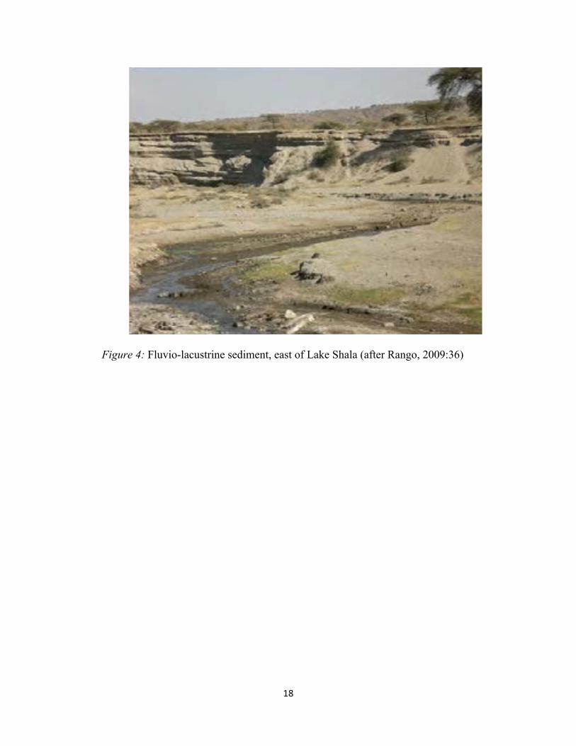
Figure 10: Geological log of the sedimentary formations identified in the Bulbula plain.
Archaeological site locations are illustrated for information only (the actual context and location
of B1s4 and B1s1 cannot be rendered here) (After Bon et al., 2013).
B1s4 was first discovered in 2008 and two test trenches (T1 and T2) were opened in 2009
on the site which is located on modern Bulbula canyon. Excavation at T2 was soon terminated,
but continued on T1 in 2010 by setting up a square meter grid system (squares A, B, C and D)
(figure 12). From these grids, only C and D were excavated on their whole surface. A and B
B1s4 sedimentary record can be divided into 5 lithostratigraphic units that measures 1.10 meter
thick sedimentary deposits of colluviums, silts and pumice (figure 12). Of these, two occupation
levels (paleosols PS1and PS2) were identified, which they are separated each other by 30 cm
hiatus thick intermediary silt. PS1 and PS2 contain abundant materials made of obsidian and
31""
faunal remains. In addition to the two paleosols and the intermediary silt, two sterile horizons
were exposed as the older (bottom layer) and younger (top layer) stratigraphic units (Bon et al.,
2013).
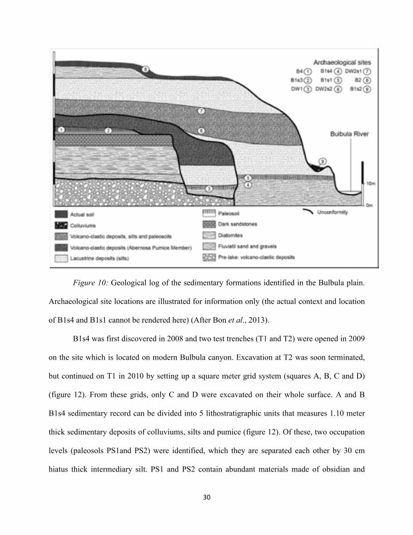
Figure 11: Radiocarbon dates of archaeological sites from the end of the Pleistocene and
the beginning of the Holocene and for comparative purposes, the GICC05 curve. (after Bon et
al., 2013).
32##
Table 1: radiocarbon dates of archaeological sites in Bulbula and sites outside the Ziw
ay-Shala Basin. D
ates for comparative
purpose taken from other researcher publication (after M
enard, 2014).

33""
The lowest and the oldest stratigraphic units were made up of brown colluviums deposit
that does not preserve any cultural materials and faunal remains. This lowest level was overlain
by a paleosol (PS1), containing the oldest human occupation horizon which is dated by a single
radiocarbon date to 12,040±50 (14,045-13,755 Cal BP). The large proportion of lithic materials
from the total assemblage was derived from PS1 which yielded the majority of lithic artifacts and
some faunal remains. PS1 is overlain by sterile 30 cm thick intermediary silt which separates
PS1 from PS2.
Figure 12: view of B1s4 at the end of excavation in 2010. In black stratigraphic units; in
blue grid units and in what location of the 2009 trench (courtesy of F. Bon and C. Ménard)
34""
The PS2 stratigraphic unit is interbedded by the pumice formation and intermediary silts
at the top and the bottom respectively. This unit measure 15 cm thick and have yielded few
number of lithic assemblages and faunal remains. This unit has not yet been dated but probably it
is the upper most of the Terminal Pleistocene phase. PS2 is overlain by 50cm thick pumice
deposit and thick silt formation of the early Holocene lake deposits (Ménard et al., 2014).
Correlation of the cultural horizons of B1s4 with other sites in the Ziway-Shala basin and
other Late Pleistocene sites containing lithic assemblages is still problematic because yet it lacks
complete and detail record of sedimentary deposits Late Pleistocene sites in the country. All the
identified radiocarbon dates in the Ziway-Shala basin did not closely correlate with B1s4 human
occupation horizon dated to 12,040±50 (14,045-13,755 Cal BP). The human occupation horizons
in the Ziway-Shala basin and the rest parts of Ethiopia are either older or immediately younger
than B1s4. The nearby B1S1 site (Habte, 2013) has a calibrated date on the two occupation
horizons that ranges between 13,467 and 13,196 cal BP (Bon et al., 2013), which is younger than
B1s4 dated 14,054-13,755 cal BP. This period was part of the terminal Pleistocene, which
appeared shortly before the Younger Dryas abrupt climatic condition and some places in
Ethiopia, such as Lake Besaka was marked by cool and extensive arid condition. Evidence of
human occupation were hardly recognized except identifying few pieces LSA assemblage which
were uncovered from weakly developed paleosol at Lake Besaka (Clark and Williams, 1978;
Brandt, 1982).
2.4.Cultural and Chronological Sequence of LSA Industries in Eastern Africa
The Stone Age archaeological record in Africa covers the entire Pleistocene and the latest
Pliocene (dated c. 2.6 million years ago) (Semaw et al. 1997). This prehistoric cultural
sequence in Africa, South of the Sahara, is divided in three phases: the Early Stone Age

35""
(hereafter is called ESA) (including Oldowan and Acheulian), Middle Stone Age (here after is
called MSA) and Late Stone Age (LSA) (Willoughby, 2009: 303). These schemes were first used
by Goodwin and Van Riet Lowe (1929) on the basis of archaeological materials discovered in
South Africa. These periods can be distinguished from each other on the basis of changes in
stone tools technology.
The Early Stone Age begins with the first appearance of stone artifacts such as Oldowan.
The Oldowan, which is dated between 2.6-1.5 Ma, uncovered in the archaeological sites in
eastern, northern and southern part of Africa. The lithic artifacts dated from these period are
cores, whole and broken flakes, core angular fragments, a small number of retouched pieces and
in some instance unmodified stones transported to site. But c.1.5 Ma, the Oldowan lithic
industry, which lasted over 1 million years, was replaced by an advanced stone working tradition
in Africa which is called Acheulian (Semaw, 1997; 2000:1198). The Acheulian, on the other
hand, is different in its types from Oldowan and manifested by bifacial tools of variable size and
shape manufactured on flakes. Morphologically, the Acheulian is classified into handaxes,
cleavers, picks and other types.
Around 200,000 years ago, the Acheulian lithic industry disappeared and new flake tools
struck from radial, discodial, or Levallois cores continue as MSA until the beginning of LSA.
MSA Assemblage is characterized by the appearance flaked lithic industries including points,
scrapers and other thin flakes tools (Clark, 1988: 236; Goodwin, 1928; 1929; Willoughby,
2009:303, Bar-Yosef and Kuhn, 1999) which comes to an end in Africa between 30,000 and
40,000 years ago (Clark, 1988:236). In some places in East Africa the MSA component includes
the Heavy Duty core-ax or pick, the production of blades and some LSA components like borers
of various kinds, burins and backed forms (Clark, 1988:236).

36""
The temporal transition from MSA to LSA in East Africa was not well dated so far
(Clark, 1988: 236), but recent research which has been conducted in Ethiopia in the Ziway-Shala
basin(Ménard et al., 2014) and Goda Buticha in southeastern Ethiopia basin have produced
important data to inderstand the temporal transition from LSA to MSA. This transition in East
Africa especially remains equivocal because the transition appears to be at or beyond the limits
of radiocarbon dating, around 40-45,000 years BP. On the other hand, other dating methods did
not provide reliable and exact dating results. This transition period in Sub-Saharan Africa is
equivalent to the Middle/ Upper Paleolithic (MP/UP) transition in northern Africa and western
Eurasia (Clark, 1988:236; Ambrose, 1998:377; Klein, 1992)"despite it is a bit outdated idea to
consider MSA/LSA as equivalent to MP/UP and research on the later transition during the last
decades made big progress which indicate complex processes in a short period of time compared
to what we know of the MSA/LSA (Ménard , Per. Communication, 2015).

37""
Figure 13: Location major LSA sites in Eastern Africa. Not all the sites are discussed on
this thesis (after Kusimba, 2001:79).
According to Clark (1988), the transition to LSA occurred at much the same time as in
other part of continent dated between 30,000 and 40, 000 years ago. However, according to

38""
Mabulla (1996), LSA associated technological culture was dated sometime between 50 ka and 20
ka and evidence of the earliest date of transition in east Africa came from Kenya at Enkapune
Yamuto rock shelter. Radio carbon and obsidian hydration dates indicate that the transition from
MSA to LSA may have occurred by 50,000 BP. In Enkapune Yamuto, the younger Early LSA
was found in association with ostrich eggshell head manufacture, which dated to 39,000 BP
(Ambrose, 1998, 377). The other early transition evidence came from one of the late MSA site,
Midhishi 2 in Northern Somalia, dated ≥ 42,000 BP (Brandt and Brook, 1984). In southern
Africa, however, MSA has persisted to appear during “typical” LSA times, ending about 20 ka
BP (Mabulla, 1996:21).
In the Horn of Africa, the transition between the MSA and LSA provided the Somaliland
variant of the Magosian and intrusive blade and burin industries of the Hargesian. The Magosian
mainly identified in southern Somalia, the Ogaden, and the Afar Rift, and the Hargeisan was
found in northwestern Somalia (Clark, 1954). According to Clark (1954), this transition period is
characterized by maintaining both MSA and LSA elements which comprising ‘Stillbay’ MSA
features such as points, levallois cores and flakes as well as LSA forms including microliths,
blade tools and blade cores. LSA features in Somalia include two industries which developed
from the end of the Upper Pleistocene onwards, the Doian and the Somaliland Wilton (Clark
1954; Brandt, 1986:44, 59). In Ethiopia, however, the transition from MSA to LSA is not
established based on the sites previously studied. Due to this, the tempo and mode of cultural
change from MSA and LSA remains poorly known. But, at least there is one LSA earliest site
dated radiometrically in Ethiopia at Ziway, where an exposed section near the Bulbula River
revealed an occupation horizon embedded within a paleosol dated on charcoal to ca. 27,050 ±
1,540 BP (SUA-588) (Gasse and Street, 1978; Gasse et al., 1980). At this site, lithic

39""
assemblages such as non-microliths, scrapers, and blades made from obsidian were discovered
on the surface (Brandt, 1986: 62-63). In addition to this, the excavation at Lake Besaka had
yielded artifacts of blade technology dated to 22,675 ± 500 BP. At Laga Oda, the microlithic
industry, using mostly chert, was dated to 15,000 years ago
The Term LSA is originally was used to describe prehistoric flaked stone industries
uncovered in the Stone Age sequence of South Africa in which these materials has shown a close
resemblance to the material culture of the last stone tool using people in the Southern Africa. It
was later the terminology of LSA has been used for all of the Sub Saharan Countries to define
the cultural sequence of the period (Goodwin and Lower, 1929). According to Clark (1969),
Chronologically LSA is marked by Later Pleistocene and Holocene industries (be “Mode 4”
and/or “Mode 5”). LSA industries are commonly dominated by backed microlithic tools and
blade-core technology (Brandt, 1982:8) and marked by the existence of blades- and small flake
based industries, burin (gravers), bladelets and end scrapers (Ambrose, 1998; 2002; Kusimba
2005; Klein, 1992) which were technologically made from on cores which has a plain platforms
(Ambrose 1998:377) and that are much easier to replace a mutual exclusive (Klein, 1992). In
fact, blades and backed tools were discovered in Euroasia sites which were occupied by
behaviorally archaic humans. But in Africa, blades and backing tools were often considered
important features of the technology of behaviorally “modern” human during MSA period
(McBreaty and Brooks, 2000) despite the shift to modern human behavior appeared during LSA
in Africa (Ambrose, 1998).
LSA industry is known for its high degree of standardization and internally more
morphologically variable tools forms which were used in a wider range of specialized and
distinct activities. The other characteristic associated with LSA is that tools which were not used

40""
in MSA/MP including bone, antler, or ivory began to appear and become part of formal artifact
types. These tools could be whittled, carved, or polished into a variety of useful artifact types
which are a constant feature of LSA (Klein, 1992; Bar-Yosef, 2002:366). These shifts are
interpreted as reflecting changes in style (i.e., transmitting cultural information) and rarely are
related to functional needs (Bar-Yosef, 2002: 366).
LSA cultural sequence was also known yielding as personal adornments in a form of
perforated ornaments including beads and pendants which were made of marine shells, teeth,
ostrich eggshell (e.g. in Kenya at EYM rock shelter) and ivory (Klein, 1992, Bar-Yosef, 2002:
367; Ambrose 1998: 377). These are considered the self-awareness and identity of the individual
as well as social groups (Bar-Yosef, 2002:367). The use of these objects of personal adornment
also provides additional information about the exchange pattern and relationships among
individuals and bands, and among the neighboring groups (Ambrose 1998:377). Klein (1992) has
suggested that unlike the MP, LSA/UP art and personal adornment became one characteristics
feature of UP sites. LSA/UP is marked by rapid differentiation into wide range regional and
temporal variants. It is widely recognized by lithic assemblages that show temporal and spatial
heterogeneity (Klein, 1992).
The LSA is known more in the shift in diet compared to earlier MSA. More diverse diets
were included in the faunal assemblage of LSA hunter-gathers (Bar-Yosef, 2002; Steele and
Klein, 2009). The most significant document shift is the appearance of small, quick, difficult to
catch game, such as fish, birds, hares and small carnivores faunal remains in southern Africa
costal sites, but absent from comparably located sites during MSA. In addition big and dangerous
terrestrial games such as buffalos and wild pig were also included in the diet of LSA people in
southern Africa (Bar-Yosef, 2002; Steele and Klein, 2009). This new diets may be the result of

41""
the innovation new technology that made it possible to more efficient to capture these resources
(Steele and Klein, 2009). Evidence of these new tools forms in a form of microlithic tool forms
began to appear LSA sites that dated after 20,000 BP. These tools were probably mounted or
inserted in bone or wooden handles or staff. The ethnographic research data show that
microlithic pieces associated with bone LSA assemblages were probably parts of the composite
arrow, while other bone and stone artifacts were probably used for fishing.
2.5.Adaptation and subsistence Strategies of Late Stone Age Hunter-Gatherers
According to Mabulla (1996, pp. 37-38),
“Adaptation is a useful concept that can be used to investigate variabilities in human behaviors, culture, and biological design in time and space. It is the means by which human-environment relationships develop. Therefore, adaptation can be used to account for changes in the human behavior and culture. …archaeologists and anthropologists of cultural economy and ecosystem persuasions view adaptation as a process whereby humans actively and intentionally direct change in their strategies and tactics of survival. Taking this perspective, Bennett (1984, p. 246) defines adaptation as a “set of psychological process which are probably universal or nearly so, and situations”. To Bennet, adaptation is the product of the interaction between particular historical processes and human institutions. According to Hardesty (1986), cultural adaptation occurs because of changes in technology, organization, ideology, in short all aspects of culture. To Denevan (1983, p. 401), adaptation is “the process of change in response to changes in physical environment or a change in internal stimuli, such as demography, economics and social organization.”
All these definitions and explanation about adaption have shown that adaptation is a broad
concept, and for my thesis I have to governed by my research questions and objectives and I
want to limit adaption to issues that related to direct change in their strategies and tactics of
survival like economic subsistence, mobility and settlement patterns.
The subsistence pattern of hominids was not the same throughout the history of human
evolution. It has a temporal and spatial variations resulted from changing environmental
condition and changes in technology combined with changing social and settlement strategies

42""
(Conard, 2007). In East Africa there is no enough data used to reconstruct the subsistence
behavior of MSA and LSA population which is partially because of lack of previous research in
the region. But, southern Africa is particularly rich in evidence bearing on the subsistence of
Middle and Late Stone Age people (Klein, 1983). The available limited faunal assemblages,
particularly in southern part of Africa, has proved that there was a dietary changes between MSA
and LSA and even in later this change had brought a major change on human behavior that led to
the expansion of modern humans out of Africa (Steele and Klein, 2009).
Numerous faunal remains, including large ungulate mammals of Buffalo and elands,
were recorded in the caves which once had been inhabited by MSA and LSA people in Sothern
Africa at Klasies River Mouth Cave 1 and Nelson Bay cave respectively (Klein, 1983). LSA
people were also known by intensive use of the existing and new diets in their subsistence which
were not often used or part of MSA population. In southern Africa LSA diet was known by
increased exploitation dangerous games, such as buffalo and wild pigs; increased exploitation of
marine mollusks, tortoises, and airborne birds; as well as the addition of fish occupied under
comparable climate and environmental condition during the present interglacial (Steele and
Klein, 2009; Klein, 1983). According to Klein (1983: 43), the evidence of the exploitation of
new species including fish and fowl by LSA people has been supported by the discovery of
fishing and fowling gear on LSA sites. These artifacts include grooved stones that were probably
used as line or net sinkers, as well as bone “gorges” that were probably baited to catch either fish
or flying sea birds (Klein, 1983).
In the Horn of Africa, there is no substantial data that provides evidences for the
subsistence strategies of late upper Pleistocene hunter-gatherers. Our knowledge of subsistence
and dietary practice of LSA hunter-gathers for this period has been relayed on very small faunal

43""
remains from the Lake Besaka site of FeJx4, dated to ca. 22,000 years. At Besaka, later
Pleistocene and terminal Pleistocene stratigraphic sequence had provided hundreds of highly
fragmentary animal bone and dental remains, 885.5 gm of ostrich eggshell fragments and small
sample of fish bones which probably all these animal species were the subsistence and dietary
preference of LSA hunter-gatherers. Bovids and hippopotamus cheek tooth fragments dominated
the whole faunal assemblage in most unites. Bush pig dental fragment and/or warthog as well as
rodent incisors and jaw fragments were also identified. Other faunal remains included post-
cranial remains of a few reptile, rodent incisors and jaw fragments. Fish remains dated as old as
22,000 BP were also uncovered in a form of cranial and post-cranial element (Brandt, 1982).
2.6.LSA Raw Material Exploitation and Socio-Territorial Organization Pattern
The distribution and availability of lithic raw materials play an important role to understand
how humans manufactured, used and reconfigured stone tools. It provides information for us
about prehistoric people exploitation of their environment. The sources of raw material have the
capacity to provide robust information about circulation of stone across the landscape. Therefore,
locating the sources of raw material and investigation the procurement strategies are important
tools for prehistorians who want to seek information on human land use and mobility pattern,
and relating these to lithic technology. The availability of lithic raw materials is also a
determinant factor in tool and core technological reduction strategies (Andrefsky, 2008).
This local raw material would be important to provide information about procurement
strategy and raw material transport in to the site. As it was known, raw materials into the site
were transported into different strategies. It could be transported into the site as a natural nodule,
roughed out cores, tool blanks or finished tools. It is argued that raw material raw material

44""
procurement has direct or indirect influence on technological choice of the makers of stone tools
of the prehistoric hunter-gathers (Andrefsky, 2009: 76).
In addition, exploitation of lithic raw materials, which needs an accurate knowledge to know
the location of lithic sources actually exploited, provide information about the circulation of
lithic artifacts across the landscape. Higher levels of behavioral inferences, such as home range,
mobility pattern, and the evolution of regional interaction networks, reciprocal intergroup
materials, information exchange and cooperation for risk reduction, are drawn from data on lithic
site-to-source distance (Ambrose, 2006).
According to Bar-Yosef (2002:367), UP/LSA hunter-gathers had wider range of contact
that covers hundreds kilometers through long distance exchange networks in lithic, raw
materials, and marine shells. Their network and exchange system are different from MSA/MP
people who were restricted to shorter ranges of raw material procurement. But this short raw
material procurement pattern did not work for Howiesons Poort MSA hunter-gathers in South
Africa because raw material was transported to the site from a long distance (Bar-Yosef, 2002).
In East Africa, the dry grassland LSA hunter-gathers were highly mobile which crossed the
landscape following herds of migratory ungulates. Because of this mobility, LSA hunter-
gatherers in East Africa controlled large home ranges and had an access to with herds through
either predictable moments or visual sighting from looking outs on high terrain. Their sites are
characterized by ephemeral and seasonal occupation. However, the ethnographic study that
conducted on modern desert hunter-gatherers provided different subsistence and mobility
strategy. The ethnographic model proved that plant food has constituted the majority part in the
dry and tropical environment in the Kalahari and Hadzabe of northern Tanzania hunter-gatherers.

45""
Furthermore, it is not the location of the animals, but the location of water sources, that
determines much of individual and group movements (Kusimba, 1999).
2.7.Characteristic Feature of Blades and Bladelets and their Production Techniques
B1s4 lithic assemblages from Bulbula are characterized predominately by blades and
bladelet typology. So, it is worth noting to provide some notes about widely accepted criteria
proposed by previous research works to distinguish blades from bladelets. According to
Kauffman (1986), a number of attempts have been made by various researchers (e.g. Tixier
1963, Heinzelin, 1962 and Marks, 1968) to define blades and bladelets on the basis of metric
attributes including length, width, length/width ratios or combination of these. On the basis of
these attributes, the most widely accepted criteria is that bladelets are defined flakes as having
length equal to or greater than twice their width (length/width ratio= 2:1) and also defined by
maximum width of 12 mm, and maximum length of 50 mm. It includes also flakes longer than
50 mm, but its width yet not exceeds 12 mm. Additional definition for blades and bladelets is
given by other authors and their metric attributes are different from Tixier (1963) (See details in
Tixier, 1963 cited in Heinzelin 1962; Marks, 1968; Kauffman, 1986). On the other hand, blades
are conventionally defined as flakes with length greater than twice their width and compare to
bladelets, it is significantly greater despite differentiating blades from bladelets is inherently
ambiguous and subjective (Kauffman, 1986; Ambrose, 2002).According to Inizan (1999), the
production of these debitage pieces was a technical choice for the objective of either large
debitage product (blades) or small ones (bladelets and micro-bladelets). So the availability of raw
material does not have an influence for the choice of the debitage product (Inizan, 1999: 73). The
failure to make clear classification between the two results from the overlapping nature of the
blade and bladelet length as well as the quantifying definition of blades versus bladelets given by

46""
researchers (Kauffman, 1986; Ambrose, 2002). Therefore, all these definitions prove that still
there is gap to establish a universal set of principles and boundary between blades and bladelets.
A substantial difference has been seen in different regions depending on raw material size,
mechanical properties, types of hafts, style, and other factors. Relatively, depending on
quantitative description of length and width ratio is better despite problems arise relates to
subjectivity (Ambrose, 2002: 9-10)
In Sub-Saharan Africa, microlithic industries are found in association with blades, but
defining and identifying microlithic industries relaying on blades is misleading. Because in Sub-
Saharan Africa several early microlithic industries were not blade/bladelet based and in others
blades do not always form a distinct mode among the flakes (Ambrose, 2002: 9-10). In Africa
this microlithic industries were fully developed by 20,000 years ago despite the microlithic
industries went back to 80,000-90,000 years ago and found in a form of small blade industries
(Clark, 1985:95). According to Clark (1985: 95), microliths are based on the manufacture of
bladelets and flakelets in which the dimension of their length does not exceeds 50 mm and the
great majorities are less than 30 mm long. Typologically, microliths industries were composed of
variety of backed tools and small convex scrapers, together with a range of other artifact forms,
some of which may be macrolithic in size. Such kind of tools are the characteristic feature of
LSA industries in Africa south of the Sahara, despite not all LSA industries are yielded
microlithic proportions (Clark, 1985:95)
LSA industries in Africa is also known by blade and blade segments which were often
blunted (backed) by different techniques including steep retouch parallel to or truncating one or
more ends of straight sharp edge were used during backing. Morphologically, backed microliths
can be found either geometric or non-geometric forms. Crescents, triangles, trapezes, deep
47""
crescents, petites tranchéts (deep trapezes) and rectangles are geometric forms identified in
African LSA industries. Non-geometric forms include curved backed, straight backed,
orthogonal, oblique, and longitudinal truncations. In relation to size, backed tools are widely
varied. For example in the earlier phase of Eburran industry, backed microliths were identified
with mean length approaching 50 mm (but the maximum lengths of approximately 100 mm). To
the opposite backed microliths pieces of extremely small with mean length less than 17 mm were
found in some Holocene LSA and Neolithic industries (Ambrose, 2002:10).
Varieties of techniques are used for the manufacture of blades and blade-like flakes (Bar-
Yosef and Kuhn, 1999). Both blades and bladelets are removed using direct percussion (using a
hammer stone, wood, or antler), indirect percussion and pressure flaking. But it is not easy to get
the desired blade products using a raw material in its natural condition and due to this the desired
shape of the blade is achieved by shaping out of the core, and to the preparation of striking or
pressure platforms and most particularly to the preparation of one or more “ridges”, called crests.
(Inizan, 1999). In classic prismatic flake production, one or more long ridges are prepared on the
face of the core by bifacial flaking, creating the characteristic crested blade (lame à crête). In
such a way a blade core produces a series of blades throughout its perimeter. Flat and
unmodified or platforms prepared by flaking or abrasion would be used for the production of
blades on the prismatic core (Bar-Yosef and Kuhn, 1999). But this does not mean that blades do
not produced in blade cores without crested ridges. Some blade cores which have sufficient
convex area of cortex surface are convenient for blade debitage production (Inizan, 1999)
48""
Chapter Three
Literature Review
3.1. Previous Research on Late Pleistocene LSA
3.1.1. Late Pleistocene LSA sites in East Africa
In Eastern part of Africa, archaeology is a young discipline in which a scientific research
on the field has started in the 1920s. Prior than the 1920s, archaeological exploration and
research were conducted by travelers, colonial administrators, explorers, and foreign enthusiasts
(Mabulla, 1996). In East Africa, the first systematic prehistoric research was begun by E.J.
Wayland, who was the Director of Geological Survey in Uganda in 1920 (Clark 1988). Wayland
divided the later sedimentary deposits of the country and he developed threefold glacio-plluvial
hypothesis. In 1926, L.S.B. Leaky’s East African Archaeology Expedition conducted its research
in the basins of Lakes Naivasha and Nakuru in Eastern Kenya. On these sites, stratified, fine-
grained sediments in Malewa Gorge yielded lithic assemblages which were described as later as
“Kenyan Mousterian” and “Kenyan Stillbay” (Leaky, 1931; Clark, 1988: 241-242).
3.1.2. Previous Research on Late Pleistocene LSA sites in Ethiopia
According to Brandt (1982), in the Horn of Africa which includes the modern countries
of Ethiopia, Djibouti and Somalia, the earliest attempt to record MSA/LSA had been taken place
by Revoil between 1882 and 1888 along the coast of Somalia. In Ethiopia, the first systematic
prehistoric research was commenced with discovery and excavation of the MSA site of Porc
Epic cave near Dire Dawa town by Teillhard de Chardin and Henry de Monfreid between
November 1928 and January 1929 (Clark, 1954).
In the 1940s, Desmond Clark has commenced his Stone Age research and he documented
sites with surface findings as well as he excavated a series of stratified MSA/LSA rock shelters

49""
and open air sites in Ethiopia (Brandt, 1986: 42). The 1940s and earlier research work of Clark,
which were conducted in Ethiopia and Somalia, were compiled together later and Clark (1954)
published The Prehistoric Culture of the Horn of Africa. In the 1940s, Lieutenant-Colonel
F.Moysey had also conducted his investigation in the northern and northwestern part of Ethiopia
and had excavated Quiha rock shelter in the 1940s while he was serving with British armed
forces in British Somaliland. The Quiha rock shelter is located in Tigray province in northern
Ethiopian highlands, close to the town of Quiha and Mekele. The LSA/Neolithic lithic materials
discovered at Quiha include high frequencies of obsidian microliths, small scrapers, blades and
blade cores. They have never been fully published (Barnett, 199) but, these materials were dated
to the Late Prehistory (Moysey, 1943; Leakey, 1943). Mosey had also partially excavated
Gorgora rock-shelter in 1943, which is located to the North of Lake Tana in northwestern part of
Ethiopia Gorgora had yielded a stratified ‘Middle Stone Age’ sequence with ‘Late Stone Age’.
The excavated materials were analyzed by L.S.B. Leaky and the analytical results show both
MSA and LSA cultural materials. The MSA debitage belongs to the culture of Stillbay
uncovered from 12-foot level upwards to the top of the 4-foot layer. Layer 4 was identified as a
transitional unit that contains lithic belongs to Magosian culture. Finally, the upper most 2 feet of
the black soil contain a very crude microlithic industry which may be regarded as a local
derivative of the Magosian, comparison to the Wilton B of Kenya and Northern Tanganyika
(Williamson, 1984; Moysey, 1943; Leakey, 1943).
In the northern part of Ethiopian plateau, the other site that provides knowledge of LSA
hunter-gatherers is Gobedra hill. According to Phillipson (1977b), the presence of Stone Age
material at Gobedra in the vicinity of Aksum has been reported first by Puglisi (see Puglisi,
1941). Then, in 1974, 4m2 test-trench was excavated and he uncovered more than 26, 000 LSA

50""
assemblages. Radiocarbon dating samples were taken on the occupation layers and calculated on
the basis of the 5568-year half-life. Based on this, the stratum IV (65-70cm) from square C was
dated 8168 B.C ± 140 years. Different types of cores, retouched implements, backed geometrics,
backed flakes, backed points, blades and various types of scrapers were discovered (Phillipson,
1977b). In Northern Part of Ethiopia, Finneran also recorded various sites with their LSA
occurrences (See Finneran, 2000; 2001; 2003).
In the 1970s (1974 and 1975), University of California Expedition under the direction of
Professor J. Desmond Clark and M.A.J Williams had begun a survey and excavation in the
southern part of the Afar rift and southeastern plateau in Ethiopia and discovered important sites
containing LSA and/or MSA cultural sequence. This was a multidisciplinary research expedition
consisting of archaeologists from Berkeley and geomorphologists from Macquarie University
who carried out an excavation and survey from 1974 to 1976 at K’one/Garibaldi (Middle and
Late Stone Age), Lake Besaka (LSA), Aladi Spring (Middle and Late Stone Age), Lega Oda
(prehistoric rock art and LSA), and Porc Epic (Middle and a few extent Late Stone Age) (Clark
and Williams, 1978; Kurashina,1978, Clark and Williamson, 1984).
One of the sites which had been excavated by the research team of University of
California Expedition was Porc Epic, near to the town of Dire Dawa. After the 1933 excavation,
Porc Epic was revisited and re-excavated in 1974 by this research team. When they started re-
excavation, the top surface was found refilled by fine sand and loam which contains a number of
LSA artifacts from the 1933 excavation backfill. The excavation was continued in 1975 by J.D.
Clark and Williamson and later by Williamson in 1975. The cave was occupied by LSA hunter-
gathers temporarily who were used lithic assemblages dominated by microliths, small scrapers
and outils ecailles (Clark and William, 1984). LSA dating results of Porc Epic sediment deposits

51""
was based on a sample taken from dripstone sealing the main artifact-brecca and was dated by
14C and TH/U methods to ca. 4590 ± BP (pta-2600) and 6270 ± 1020 years (U-111)
respectively.
In the district of Dire Dawa, there is also Goda Buticha cave site which is located close to
hamlet of Kunama in the administrative district of Serkama village. Excavation at this cave
yielded MSA and LSA cultural materials which were uncovered 2.3 m-deep sedimentary
sequence. This sedimentary deposit has provided two occupational phases which were dated to
the Upper Pleistocene (~43-31.5 ka cal BP) and in the Mid-Holocene (~ 7.8- 4.7 Ka cal BP)
(Pleurdeau, 2014).
The other LSA site who attracted the attention of archaeologists for long was Laga Oda
rockshelter, which is situated on the foot hills of Chercher Mountains. Originally, Laga Oda was
known by its prehistoric rock art which was discovered in 1933 by Pere Azais and Oncieu de
Chappardon (H. Breuil, 1934 cited in Kurashina, 1978; Brandt 1986). Researchers had continued
to revisit Laga Oda and from 1950-1952, Frobenius Institute’s Ethnological Expedition to Laga
Oda had traced and photographed the paintings as well as did small excavation and surface
collection lithic assemblages. The upper part of the floor of the shelter did not have deposit, but
there was at least 140 cm deposit in the lower part of the shelter which spans 20 meters with a
deposit of 1-3 meters. This test excavation by Elizabeth Pauli on this lower level had yielded
flakes, blades, retouched or utilized pieces, cores burins, backed microliths and scrapers made
from obsidian and chert (Kurashina, 1978). Despite it did not have a radio carbon date
(Kurashina, 1978), as Clark (1954) suggested, the discovery of these lithic assemblage at the
lower level had proved that the shelter had been inhabited by LSA people who were probably a
part of the Somaliland Wilton Industrial Complex. At Laga Oda, in 1975, University of

52""
California Expedition under the direction of Professor J.D. Clark had excavated a trial trench
measuring 4x1m2 and uncovered lithic artifacts and faunal remains. Like the 1950s materials,
they discovered crescents (asymmetric and symmetric), geometric microliths, backed flakes,
scrapers and other LSA materials made from chert, quartz, obsidian, basalt, lime stone and
granite (Kurashina, 1978; Clark and William, 1978). According to Brandt (1986), Laga Oda is
the only one among LSA sites in the Horn of Africa that provided securely dated evidence of
human occupation during the arid terminal phase (SUA-475) 15,590 ± 460 BP.
Kone is the other important MSA/LSA site which is located in the southern Afar Rift
approximately 150 km east of Addis Ababa. It is composed of eight volcanic calderas of the
volcanic age. Professor J.D. Clark and his archaeological and geological research team members
surveyed the area and discovered Middle and Late Stone Age obsidian workshop floor (Clark
and Williams, 1978; Brandt 1986). They carried out an excavation in 1974 and 1975 and
uncovered considerable number of MSA and LSA prehistoric sites sealed in primary context.
LSA artifacts were derived from the upper vertisol (black organic layer) measuring 1.0 m thick at
locality C, East Grid. Underlying the upper vertisol layer, 1.5 m thick upper loam dominated by
calcareous was identified and this stratigraphic layer kept MSA/LSA transitional artifacts, dated
to 14,670 ± 200 BP. These LSA lithic assemblages were analyzed by Hiroyasu Kurashina (1978)
for his Ph.D dissertation and he classified these materials in to shaped tools, utilized pieces and
debitages (including flakes and flake fragments, microburins, krukowsky microburins, core and
chunk).Numerous shaped tools were identified including a single La Mouilla, point, backed
flakes, scrapers and burins. All these tools are made up of good quality black obsidian and have
remained in fresh condition with no cortical retained (Kurashina, 1978)

53""
Aladi Spring was also another site which excavated by University of California research
team in the 1974. The stratigraphy of the excavated trench was formed a sequence of alternating
clays and loams that contained LSA and MSA lithic assemblages. These deposits were overlied
by a shell-bearing tufa deposit radiocarbon dated on shell 11,070 ± 160 BP((I-7970) (Clark and
Williams, 1978) and this LSA horizon, which was analyzed by Tegenu Gossa for his M.A.
thesis, was characterized by microblade industry including scrapers, bladelets, burins,
drills/borers, backed pieces and cores which are made of obsidian and chert (Gossa, et.al., 2012;
Williams et al., 1977; Clark and Williams, 1978).
According to Fernandez et al. (2007), LSA and MSA published maps in Ethiopia and the
Horn are not only show few sites but also reveal empty space stretching throw the whole western
part of Ethiopia. To fill this enormous gap, in 2001 and 2002 V.M. Fernandez had conducted
survey and excavation at K’aaba and Bel K’uru’umu rock shelters in Benishangul-Gumuz in
western part of Ethiopia which hasn’t been given an attention in so far (Fernandez et al., 2007).
The excavation at K’aaba had revealed 1.10m sedimentary deposit and radiometric dates were
identified. For the upper sample (middle level D), estimating radiation does from a fraction of
sediment collected that brought a date of 2600 BP. For Bel K’uru’umu rock shelters, the oldest
radiometric date is 4964 ± 340 BP based on samples took from level E or Unit 10 (Ua-19922).
Despite these late dates, the K’aaba and Bel K’uru’umu lithic assemblage technological features
are fairly comparable with the Midhish model (except the microliths), which was dated to 18,790
± 340 BP (Fernandez et al. 2007).
Relatively detailed and complete LSA research in Ethiopia had been taken place at Lake
Besaka. Four localities (FeJx1-FeJx4) were excavated in 1974 and 1975 by Clark and Willams
and by Brandt in 1977 and yielded later Pleistocene/ Early Holocene microlithic assemabalge as

54""
well as other artifacts belongs to more recent times. The excavated sites are situated in three
distinct physio-graphic areas. Lithic assemblages collected from the four localities were analyzed
by Steven A. Brandt as part of his PhD dissertation and detailed lithic typological and
technological analysis is provided by Brandt (1982). Chronologically, human occupation
horizons dated from 22,000 BP to the late Holocene period. However, the prehistoric human
occupation at Besaka is not continuous and by using the various occupation horizons and their
associated lithic assemblages Brandt (1982) has developed cultural and environmental sequence
of the region by dividing into different periods/phases of varying length and occupational
intensity. Five temporal phases has been recognized which form a single technological tradition
known as Ethiopian Blade tool Tradition (Brandt, 1982).
The later Pleistocene Phase: evidence of habituation of hunter-gathers in the Later
Pleistocene phase was recorded at Lake Besaka and this phase was securely dated to 22,000-
19,000 BP. This date provides the earliest well documented evidence in the Horn of Africa for
microlithic base Late Stone Age industry (Brandt 1982). Brandt (1982) also mentioned that other
researchers (eg. Philllipson 1976, 1977a, 1980 and 1982; Bower 1982) had identified similar
kind of microlithic Late Stone Age industry which had been developed and used in East Africa
roughly 20,000-35,000 BP. This new technology in East Africa, which was based on bow and
arrow was, a response to adaptation to the changing to environmental condition from more open
plains to dense vegetation cover.
Terminal Pleistocene: According to Brandt (1982), Terminal Pleistocene is the last part
of the late Pleistocene period that covers c.18,000-12,000 BP and at Lake Besaka this period has
known by paucity of archaeological remains. Lack of evidence of human occupation horizons of
the Terminal Pleistocene compared to other known phases in Besaka may be either sampling

55""
problem or may be a reflection of the cool hyper-arid conditions that was prevalent in Ethiopia
and the Afar rifts (Brandt, 1982).
Earliest Holocene: this phase began to shortly before 11,400 BP and soon followed by
Middle and Late Holocene Phase. This is probably the period when the hunter-gathers of the
terminal Pleistocene were forced to modify the then existing culture in response to changing
resources and hunting/gathering strategies (Brandt, 1982). Brandt (1982) divides the Earliest
Holocene phase into Metahara phase and Abadir phase, in which both of them were represented
by the material culture of Besaka Industry. The material cultural of this Earliest Holocene phase
is divided into four industrial groups, but not relevant to this study except first phase may be
useful for the comparison to the Terminal Pleistocene Phase.
To sum up, the time and the mode of cultural transition from MSA to LSA technology
has not been yet well demarcated in the Horn of Africa. In the region, the most likely earlier LSA
cultural sequence was identified from the Lake Ziway area of Ethiopia where an exposed section
near the Bulbula river had revealed an occupation horizon embedded within a paleosol dated on
charcoal to ca 27,050 ± 540 BP (ca. 35-28,000 cal BP)(USA-588) (Gasse and Street, 1978;
Street, Gasse et al., 1980, ), DW1 locality at unit PSS 33,726-32,907 cal BP (Ménard et al.,
2014) and in southeastern Ethiopia at Goda Buticha cave site dated in its early human
occupation to early LSA phase (~43-31.5 ka cal BP) (Pleurdeau, 2014). "
These lithic materials from Bulbula have characterized by an obsidian blade industry
dominated by the presence of non-microliths, scrapers and blades (Brandt, 1986). The project of
Late Stone Age Sequence in Ethiopia has also been revisited the known LSA sites in Bulbula
since 2007 and uncovered LSA cultural sequence at Bulbula 1 locality (Bon et al., 2013). This
research had yielded lithic assemblages dated from the upper Pleistocene (34-33, 000 Cal BP
56""
from DW1)) to early Holocene. The Pleistocene/ Holocene transition sites at Bulbula were dated
between 14,000 and 11,000 cal BP (B1S1, DW2S2 and DW2S1) (Ménard et al., 2014).
In addition to Bulbula, several other LSA sites were excavated in 1973 by an expedition
in 1973 by an expedition from the Anthropology Department of Southern Methodist University
under the direction of Dr. Fred Wendorf. This project identified the Macho and Waso hills LSA
sites, which are situated to command a view of ancient lake. Two trenches were excavated and
they yielded an assemblage based on blade technology made of obsidian which are characterized
by non-geometric microliths, scrapers, burins, blade core and other artifacts showing general
similarity to the Late Pleistocene phase at Lake Besaka (Humphreys, 1978; Brandt 1986).
3.2. Brief Review Late Pleistocene Paleoenvironment in East and the Horn of
Africa
3.2.1. Paleoenvironment of East African Late Upper Pleistocene
The paleoenvironment records of East Africa during the late Quaternary and early
Holocene were based on a range of evidence including diatoms, microscopic charcoal, ancient
dunefields and aeolian sediments, lake-level fluctuation records, fluvial deposits, glacial features
of East African mountains and tropical palynology (Street and Grove, 1978; Kiage and Liu,
2006). Particularly, pollen records and the sacred lakes in East Africa providing continuous
records in the region covering the period from 115,000 yr BP to the present (Kiage and Liu,
2006).
The LSA cultural sequence began in Africa at least as early as 42,000 BP (Ambrose,
1998) and this earliest phase of LSA in East Africa faced cold and dry conditions which was
prevalent between 42,000 14C yr BP and 30,000 14C yr BP. Due to the cold and dry condition,
high vegetation altitude could not survive and they descended to lower elevation. Evidence of

57""
these cold and dry paleoenvironment were found in the Rukiaga highlands, in Mount Kenya,
Lake Abiyata (Ethiopia) and Kashiru swamp (Burundi) (Kiage and Liu, 2006). In Kashiru
swamo, for example, there was a decline in forest taxa and an increase in Gramineae (Bonnefille
and Riollet, 1988), which is a marker of cold and dry condition (Kiage and Liu, 2006).
Between 30,000 to 21,000 14C yr BP, records of the paleoenvironment have revealed cool
and moist conditions in East Africa and this is the period leading upto LGM period of the
Northern Hemisphere. During this period, there was a slight increase in temperature and
precipitation that led several East African lakes experienced high stands. Places covered with
ericaceous scrub in the Muchoya catchment was replaced by upper montane forest (Taylor 1990
cited in Kiage and Liu, 2006; Perrott and Street-Perrott, 1982). However, the increase in
precipitation is not recorded at all sites of East Africa. For instance, an area like Lake Albert was
dominated by an open wooded grassland assemblage, suggesting a dry climate (Kiage and Liu,
2006). The period from 21,000 to 12,500 14C yr BP in East African environment and the rest of
Africa were characterized by cool conditions, punctuated by episodes of prolonged desiccation
(Kiage and Liu, 2006; Street and Grove, 1976), which reached its climax 18,000 ± 300 yrs BP
when East African glacier reached their greatest extent (Street and Grove, 1976). Sea level
fluctuation from Lake Victoria and Lake Albert provides evidence of two separate episodes
extreme ardification of this period. This desiccation in some part of East Africa was so severe
that led to a low stand of at least 46m below present levels at the core site in Lake Albert (Kiage
and Liu, 2006). Like Lake Albert, Lake Abhe in Ethiopia at Afar reached its minimum by 17,000
yr BP and other rift valley lakes were dried up (Street and Grove, 1976). Still there is lack of data
about this period. The available pollen data are low may be because of the poor preservation of
pollen in low lake levels and subsequent oxidation in these environments (Kiage and Liu,

58""
2006).This aridity period was continued and particularly from 15,000 to 13,000 yr BP, it became
even more intense and wide spread (Street and Grove, 1976; 1979). The Terminal phase of the
last glaciations in East Africa was dated between periods after 12,500 BP and the beginning of
the Holocene (10,000 BP).This terminal phase is considered as a transition period which is
marked by an increase in temperature and moisture (Kiage et al., 2006). According to Street and
Grove (1976), this period was considered as the African counter part of the late glacial.
However, just before 10,000 BP, an abrupt return of the arid condition was recorded at several
sites in East Africa (Street and Grove, 1976; 1979; Kiage and Liu, 2006).
3.2.2. Paleoenvironment of Ethiopian Late Upper Pleistocene
Like other parts of East Africa, evidences of the late quaternary environmental changes
were recorded in different parts of Ethiopia. The earliest study of late quaternary
paleoenvironment was conducted by E.Nilson (1940) on past glacial environment of the simien
highlands of Ethiopian plateau and the lake basins including the lake basin of Tana and Yaya on
the Ethiopian plateau and the lakes in the Ziway-Shala basin that could provide
paleoenvironment relating to ancient beaches and terraces (Brandt, 1982). Most of the data for
this paleoenvironment reconstruction derived from lacustrine and fluviatile sediments, as well as
evidence from sea-level fluctuation along the Somalia coast and Ethiopia. By using these data,
Clark (1954) devised the sequence of the Late Quaternary climate change in the Horn. According
to Clark (1954), the upper Pleistocene three wet phases of the “Gamblian” Pluvial and an arid
phase of the terminal Pleistocene. Following the terminal Pleistocene, two wet phases were
recorded in the Holocene which were separated by period of aridity (Clark, 1982).
In Ethiopia most of the recent data used for the late Pleistocene paleoenvironment
reconstruction has been gathered almost exclusively from five regions: 1) the lower Omo Basin

59""
at the southern end of the Ethiopian Rift, 2) the Ethiopian plateau, 3) the Middle Awash Basin in
the southern Afar Rift, 4) the Lower Awash Basin and the lakes of the central and northern Afar
of Ethiopia, and 5) the Ziway-Shala Basin situated in the south-central portion of Ethiopian rift
(Clark, 1982). But for this study I limit myself on selected temporal phases and spatial
distributions which would be useful for correlations for my study area including the Ziway-Shala
basin, the Lowe Omo basin, lakes of the central and northern Afar and Lake Beseka.
3.2.2.1. Lower Omo Basin
At the Lower Omo basin, two major transgressions from the Lake Turkana formed
littoral, deltaic and fluvial beds of member III of Kibish formation. These transgression of Lake
Turkana, however, interrupted by desiccation (Butzer, 1970:429 cited in Brandt 1982). Late
quaternary last transgression of Lake Turkana was recorded shortly before 35,000 Bp years ago,
when Lake Turkana was 60 to 70 above its present level. Then when the desiccation started, the
level of Lake Turkana dropped left behind carbonate horizons and “desert varnish” on lag pebble
indicate long period low lake level and aridity which ending before 9500 BP.
3.2.2.2. Central and northern Afar
The longest continuous stratigraphic and climatological sequence of late quaternary was
recorded from the central (including Lake Abhe, Dobi-Hanle and Asal) and northern Afar (Lake
Afrera) Lakes. Three major lacustral phases named (Abhe I, II and III), which are separated by
more arid episodes, were identified (Gasse, 1975;1977; Gasse and Street, 1978). The first
lacustrine and arid phases were dated around 70,000 PB, which is not the main concern of this
research. But the second lacustral phase (Abhe II) was well begun before 40,000 BP and ended
around 30,000 BP, which was uncovered in the central Afar basins. During this time Lake Abhe
was marked by increasing sea level and deposition very pure diatomite. After 30,000 BP,

60""
regression was followed and this regression is recorded by a thin bed of gypsum which overlies
calcareous sediments dated about 30,000 BP (Gasse and Street, 1978).
The third lacustral phase of Lake Abhe (Abhe III) covers the time span from 30,000 -
17,000 BP, when the level of Lake Abhe reached its maximum during the late quaternary. This
phase began to deteriorate from 20,000 BP onwards and disappeared around the onset terminal
Pleistocene arid phase (17,000 BP) when it seems that all the lakes in the Afar were dried. The
dry phase continued until the end of the terminal Pleistocene from 12,000-10,000 BP when most
Afar lakes got dried (Gasse and Street, 1978).
3.2.2.3. Besaka:
The late quaternary sedimentary deposits in Lake Besaka are yielded plaeoenvironmental
data dated to late upper Pleistocene transgression period, terminal Pleistocene regression period
and early Holocene transgression period (Brandt, 1982). In the late Pleistocene transgression
phase, the earliest absolute date result is between 11,200-14,400 BP from radiocarbon samples
taken in pits E1 and E2. No dating had been taken from the earliest transgression deposits, which
underling the deposit dated 11,200-11,400 BP, in pits E1 and E2 which certainly older than its
upper sedimentary deposit. But by creating a correlation with the extensive late Pleistocene
highstand in Afar and Ethiopian rift lakes c.27,000-18,000 BP, an age of 18,000 BP was
suggested for the highstand of Besaka late Pleistocene transgression (Gasse, 1975; Clark and
Williams, 1978). During this Late upper Pleistocene phase (22,000-18,000 BP), Besaka was
probably a deep fresh water lake capable of supporting a diverse tropical fauna and flora (Brandt,
1982).
The Late Pleistocene was followed by the terminal Pleistocene regression phase which
was marked by the rapid falling of the lake level of Besaka. Absolute chromomeric dating for
61""
this phase was absent, but the dates of 11,200 and 11,400 BP are the minimal ages for the loamy
sands of pit E2. Despite there was no an absolute date for E2 before 11,200 and 11, 400 BP,
Besaka would not be exceptional and should share the traits of the hyper-arid period, which
prevalent throughout much of Ethiopia and northeastern Africa between 18,000 and 10,000 BP
(Clark and Williams, 1978; Brandt, 1982). This terminal Pleistocene (c.18,000-12,000 BP) in
Besaka was marked by cool and extensive arid condition. The amount of rain fall was small, not
much more than half of what is today. The closed vegetation which had been prevalent during
humid phase was replaced by more open and desertic conditions. The volume of Lake Besaka
was minimized tremendously and may have totally dried up. Evidence of human occupation was
recognized and few pieces of LSA assemblage were uncovered from weakly developed paleosol
(Clark and Williams, 1978; Brandt, 1982).
At the end of Terminal Pleistocene (shortly before 11,400 BP) and the onset of the
Holocene (C. 12,000-9,400 BP), the level of lake Besaka increased again and marked by a
deposit remains of a thick layer of fossiliferous diatomites up to the western fault-scrap (Brandt,
1982). During this period, Besaka was covered by closed vegetation and the lake itself could
provide an access for a diverse array of aquatic fauna and flora. LSA cultural remains were
uncovered and these hunter-gathers occupied Besaka occupied Besaka at Early Holocene had
exploited a wide range of animal and plant resources from presumably many habitats (Brandt,
1982).
3.2.2.4. K’one Crater Complex/Garibaldi Caldera Complex K’one crater complex, also known as Garibaldi, is located in the southern Afar rift 30
kms west of Lake Besaka. Surveying and excavation at K’one had been conducted by Clark and
Williams in 1975 and they had recorded clay deposit containing MSA and LSA assemblages.
The LSA bearing horizons was revealed in the upper vertisol, which was deposited after 14,700

62""
± 200 BP, and was probably synchronous with the end-Pleistocene/early Holocene wet phase
evidenced at Aladi Spring and at Lake Besaka, and with the rise in Lake Shala in the Main
Ethiopian rift at or after 14,400 BP (Grove et al., 1975)
3.2.2.5. Aladi Spring The paleoenvironmental records of the Aladi Spring, located in the base of escarpment of South-
East Plateau nearly 120 away from Dire Dawa, included two wet and three relatively dry phases
during the late Quaternary. LSA cultural sequence based on microblade industry made from
obsidian and chert was uncovered in the stratigraphic sequence of the second wet phase. This
phase has been marked by the formation of mound spring capped by tufa containing shells dated
at 11,070 ± 60 BP. The first wet phase was also identified and known by wide spread deposition
of calcareous green clay loam, possibly under lacustrine condition. Between the sedimentary
deposits of these two wet phases, brown gritty clay was uncovered and this unit was probably
formed during the terminal arid phase of 17,000-12,000/14,000 BP (Clark and Williams, 1978).
3.2.2.6. Paleoenvironment of the Ziway-Shala Basin during the Terminal
Pleistocene The terminal Pleistocene, which was part of the cold and extremely arid Terminal
Pleistocene (c.18,000-12,000 BP), was marked by cool and extremely arid conditions in which
the amount of rainfall was much lower than today, probably not more than half of today.
Climatically, it was marked by more arid Bereha (a sub-zone of arid lowlands elevating not
higher than 600-700m) type. During the Terminal Pleistocene the closed vegetation existed
before was changed in to open and more deserted conditions (Brandt, 1986).
The Ziway-Shala basin has yielded very valuable data for regional and global
paleoenvironment reconstructions (Benvenuti, 2002). Due to this, it attracts the attention of many
paleoenvironment researchers including Gasse and Street (1978), Adamson et al. (1980), Gasse

63""
et al. (1980), Street (1980) and Grove et al. (1975). After the study, these researchers have
produced in one of the two most detail and continuous records of Late Quaternary and early-mid
Holocene paleo-hydrology that provides important information about climate and environment as
yet known in East Africa (Gasse and Street, 1978; Benvenuti, 1980).
Morphological and stratigraphic evidences in the Ziway-Shala Basin have provided
records of two major periods of Late Pleistocene lake transgression to the extent of forming a
single mega or macro lakes. The earliest evidence of transgression record came from Bulbula I
and dated to earlier than 28,000 BP. Despite the extent of the lakes during Bulbula I phase was
unknown, there are data that show the water level reached at least 1,605 m, which implies that
during this phase Abiyata, Langano, and Shala formed a single lake. But the phases of this high
lake level was interrupted and followed by a minor regression and subsequent deposition of
paleosols containing artifacts of LSA assemblage.
The second major Late Pleistocene transgression record in Bulbula II phase (dated to
after 27,000) was identified and during this phase the four lakes of the Ziway-Shala basin
(Ziway, Abiyata, Langano and Shala) was formed a single lake in the region (Gasse and Street,
1978; Benvenuti, 1980). This situation has persisted until 21,000 BP with minor fluctuations
(Brandt, 1982). In East Africa, this period is characterized by cold and moist condition which is
considered as a period leading to the Last Glacial Maximum (LGM) (Kiage et al., 2006) in
which during the hyper-arid phase the lake-level in the Ziway-Shala basin dropped below 1,600
m leaving behind fluvial gravel deposits on the Alutu piedmont (Gasse and Street, 1978).
Based on evidence collected from Ziway-Shala ancient shorelines, two wet phases were
occurred after the LGM, at 14.5 and 11.5 cal. kyr BP. These wet phases were coincided with the
two de-glaciations warming phases which were interrupted by the Younger Dryas cold event

64""
observed in high northern attitudes.12.6 m long sediment core record samples was taken from
Lake Abiyata and provides data for the past 13,500 years. The diatoms from this sediments
proves that lake level fluctuation and change of the chemistry of Lake Abiyata which confirms
that conditions generally much wetter than today prevailed from ca.11 to 5.7 cal.kyr (Umer et al.,
2004: 165-167). The Terminal phase of the last glaciations in East Africa is dated between
periods after 12,500 BP and the beginning of the Holocene (10,000 BP).This terminal phase is
considered as a transition period which was marked by an increase in temperature and moisture
(Kiage et al., 2006). After Terminal Pleistocene, the level of the lakes in the Ziway-Shala basin
began to increase in the minimal scale around 12,000 BP. This was followed by two major lake
transgressions during the Holocene.
The first major Holocene transgression evidence record dated at 9,400-8,000 BP in which
during this phase the four lakes of the Ziway-Shala basin reunited and formed a single lake. This
phase is characterized the deposition of lacustrine marl towards 9,400 BP. This was followed by
a regression phase which began around 8,000 BP and marked by the formation of two buried
soils and deposit of airfall pumice. After this abrupt regression, the second major Holocene
transgression is recorded about 6,500-4,800 BP and this phase is identified by the presence of
shelly lacustrine beach gravels dated c. 6,500 BP (Gasse and Street, 1978; Brandt, 1982). This
was followed by regression of the lakes which brought the separation of Lake Ziway from the
southern lakes by 5,000 BP, and the formation of the Abijata strandlines (Gove et al., 1975). In
East Africa based on the data extracted from pollen, the early Holocene was characterized by
warm and moist paleoclimate. This period was dominated by forest pollen types accompanied by
a reduction in Graminae and an increase in pteridophytes (Kiage et al., 2006).

65""
In the Ziway-Shala basin, faunal and floral remains dated to the Late Pleistocene hyper-
arid period was not discovered. Sedimentological terrestrial investigations show that the
environment was extremely cold and dry which is unfavorable for pedogensis process (Gasse
and Street, 1978; Gove et al., 1975). The East African environment between c. 21,000 to 12,500
BP was also characterized by cool condition that brought in an episode of prolonged desiccation.
This period was marked by lack of pollen data which was the result of poor pollen preservation,
probably due to low lake levels and subsequent oxidation in the region (Kiage et al., 2006). In
the succeeding Holocene period, remains of different fauna including molluscan, fish and diatom
assemblages were identified in the lake bed deposits situated above Lake Shala (Gasse and
Street, 1978; Gove et al., 1975). These faunal remains were uncovered in both warm and cold
tropical environments. The research results of the analysis of diatom, mollusk and fish fauna, and
the algal limestone above Lake Shala proves that the united Holocene lake was relatively fresh
that supports aquatic vegetation and fish population (Gasse and Street, 1978; Gove et al., 1975).
B1s4 study site in Bulbula is dated to 12,040 ± 50 BP (14,045-13,755 Cal BP) in which
this date falls in the Terminal Pleistocene phase of the last glaciations. According to Kiage et al
(2006), this terminal phase in East Africa is considered as a transition period which is marked by
an increase in temperature and moisture. But it was also interrupted by an abrupt return to arid
condition. Data that provides information for the abrupt arid condition identified several sites in
east Africa dated before 10,000 14C BP, probably reflecting the Younger Dryas climate reversal.
Evidence for the younger Younger Dryas effect was uncovered from Burundi highlands and
Aberdare Mountains. For example in Burundi highlands the abrupt aridity was manifested by a
shift to a grassland pollen types. In other sites, Lake Albert, the forest taxa has reduced nearly to
zero and contemporarily replaced by grass pollen with an increment of 40%.

66""
Selected sites of Late Pleistocene paleoenvironment of Ethiopia was briefly summarized
by Gasse and Street (1978) and Grove et al. (1975) and like the Ziway-Shala basin lakes, the
results of these previous studies have shown transgression and regression of the lake levels in the
region. So, the late quaternary environment in the Horn in general has been characterized by
environmental fluctuations that linked with periods of increased humidity and higher lake levels
preceded by periods of increased aridity and concomitant environment and hydrological change
(Brandt, 1982).

67""
Chapter Four
Lithic Analysis
4.1. General Presentation B1s4 had yielded numerous chipped artifacts and few fragmented faunal remains. A 1.10
m deep sedimentary deposit had yielded 4061chipped artifacts which all of them are made up of
obsidian. All the lithic artifacts collected from excavation came from PS1 and PS2 stratigraphic
unit and there was a dramatic increase in the number of lithic artifacts recovered as one
proceeded from PS2 to PS1. The whole lithic assemblage from B1s4 is dominated by debitage
which accounts for 96.8% of the total assemblage. The remaining 3.2% are tools which include
retouched and utilized pieces. This chapter, therefore, have presented analytical results of these
lithic assemblages and brief analytical results of faunal remains which were sorted out by
Josephine Lesur*.
4.2.Faunal Remains
The faunal remains from B1s4 were identified by Josephine Lesur. A total of 105 fragments of
faunal remains were collected from both PS1 and PS2 stratigraphic units (Table 3).
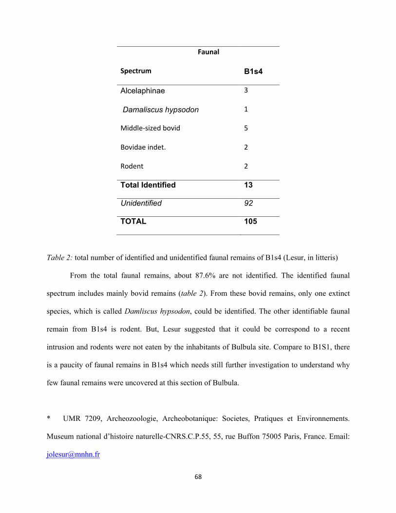
68""
""""""""""""""""""""""""""""""""""""""""""""Faunal&
Spectrum&" B1s4%
Alcelaphinae* 3"
*Damaliscus)hypsodon* 1"
Middle1sized"bovid" 5"
Bovidae"indet." 2"
Rodent" 2"
Total%Identified% 13%
Unidentified) 92)
TOTAL%%% 105%
Table 2: total number of identified and unidentified faunal remains of B1s4 (Lesur, in litteris)
From the total faunal remains, about 87.6% are not identified. The identified faunal
spectrum includes mainly bovid remains (table 2). From these bovid remains, only one extinct
species, which is called Damliscus hypsodon, could be identified. The other identifiable faunal
remain from B1s4 is rodent. But, Lesur suggested that it could be correspond to a recent
intrusion and rodents were not eaten by the inhabitants of Bulbula site. Compare to B1S1, there
is a paucity of faunal remains in B1s4 which needs still further investigation to understand why
few faunal remains were uncovered at this section of Bulbula.
* UMR 7209, Archeozoologie, Archeobotanique: Societes, Pratiques et Environnements.
Museum national d’histoire naturelle-CNRS.C.P.55, 55, rue Buffon 75005 Paris, France. Email:

69""
4.3. Presentation of Lithic Assemblage All the chipped lithic artifacts from B1s4 site from Bulbula are made up homogenous
dark-colored obsidian. Obsidian outcrops are found in the immediate vicinity of the site as
evidence of some obsidian lava flows and outcrops are found mostly on the slopes of individual
volcanoes found in the Ziway-Shala Basin. According to Di Paola (1972), from the north to
south the known obsidian flow sources include Boseti, Ittisa (inside the caldera of Gadamota),
Bericcio, Boro and Alutu, and finally the the Urji and Chabbi volcanoes (grew inside the
Corbetti caldera).
4.3.1. Raw Material Acquisition To identify the obsidian source in the surrounding landscape and to reconstruct
movement and resource exploitation, the project of Late Stone Sequence in East Africa had
conducted a survey in the neighboring regions of Bulbula. During this time, the nearest known
obsidian flow sources such as Alutu caldera and Gademotta Ridge as well as other small sources
were surveyed (Figure 2). A total 175 geological obsidian samples were collected between 2010
and 2012 in the surveyed sites and analyzed geochemically by using Laser Ablation High-
Resolution Inductive Coupled Plasma Mass-Spectrometry (LA-HR-ICP-MS) to know the
chemical composition of the selected obsidian samples. In the same manner, 108 artifacts
samples were selected from different excavated materials and were analyzed using the same
method (Ménard et al., 2014: 56). The final result of this analysis has been being prepared for
publication (Khalidi et al., in preparation cited in Ménard etal., 2014). Despite it is necessary to
wait for the final results, the preliminary investigation result has shown that the prehistoric
inhabitants of Bulbula were exploited the local raw materials which are available nearby across
the landscape. This preliminary analytical result has also brought that no distant obsidian sources
appear in the archaeological assemblage (Ménard et al., 2014: 56).

70""
4.3.2. Raw material Condition From the total 4061 pieces, whole or partial surfaces of 2070 pieces were covered by thin
to thick white carbonate coating, which is called patina, due to post-depositional surface
modification. Artifacts in which their surface is covered with patina account for 51% of the total
lithic assemblage from B1s4. The degree of this patination was considerably varies which
exhibited three different conditions (light, moderate and heavy). Most pieces were found in
moderately patinated condition that amounted 1988 pieces, or 96% of the artifacts coated with
carbonate. This was followed by heavily and light patinated pieces that form 2.5% and 1.5%
respectively. The heavy patina on the lithic surfaces prevented from the identification of the
direction of scar pattern, retouch and utilized modification and prevented use wear study in some
of the pieces. This patination condition suggests that these artifacts were affected by post
depositional activity.

71""
Figure 14: the raw material condition that exhibits thin to thick carbonate coating (patina)
The remaining 1991 or 49% are not coated by carbonate and these artifacts are well
preserved except little weathering physical condition varies from fresh (98.6%, or 1991 pieces)
to slightly abrasion condition (28 pieces, or 1.4 %).
4.3.3. Dorsal Scar Pattern and Number of Flake Scars Dorsal flake scars indicate removals from a core made prior to the removal of the flake
itself. The orientation of these flake scars to the axis of the striking platform indicates in what
direction flakes were removed prior to the movement of a flakes detachment. The orientation of
flake scars are also brings an idea the orientation and the number of platforms on a core. It also
provides clues about the method of reduction at the time the flake was removed. The direction of
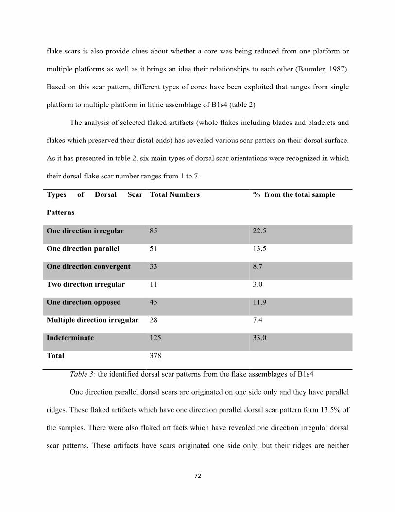
72""
flake scars is also provide clues about whether a core was being reduced from one platform or
multiple platforms as well as it brings an idea their relationships to each other (Baumler, 1987).
Based on this scar pattern, different types of cores have been exploited that ranges from single
platform to multiple platform in lithic assemblage of B1s4 (table 2)
The analysis of selected flaked artifacts (whole flakes including blades and bladelets and
flakes which preserved their distal ends) has revealed various scar patters on their dorsal surface.
As it has presented in table 2, six main types of dorsal scar orientations were recognized in which
their dorsal flake scar number ranges from 1 to 7.
Types of Dorsal Scar
Patterns
Total Numbers % from the total sample
One direction irregular 85 22.5
One direction parallel 51 13.5
One direction convergent 33 8.7
Two direction irregular 11 3.0
One direction opposed 45 11.9
Multiple direction irregular 28 7.4
Indeterminate 125 33.0
Total 378
Table 3: the identified dorsal scar patterns from the flake assemblages of B1s4
One direction parallel dorsal scars are originated on one side only and they have parallel
ridges. These flaked artifacts which have one direction parallel dorsal scar pattern form 13.5% of
the samples. There were also flaked artifacts which have revealed one direction irregular dorsal
scar patterns. These artifacts have scars originated one side only, but their ridges are neither

73""
parallel nor convergent. One direction irregular dorsal scar pattern accounts for 22.5% of the
collection which revealed dorsal scar patterns. There are also artifacts which show one direction
dorsal scar pattern. Artifacts which exhibited such kind of dorsal scar pattern are characterized
by scars originated on one side only and ridges converge towards the opposite edge. 33 pieces or
8.7% have one direction dorsal scars which converges towards its distal end. These negative
scars in general oriented in broadly the same direction may indicate that the previous flakes had
been removed from the same platform.
Other types of dorsal scar pattern such as two direction irregular, one direction opposed
and multiple direction irregular account for 3.0%, 11.9% and 7.4 respectively, while the
remaining 33% or 125 pieces have indeterminate dorsal scar patterns. Flaked pieces which
possessed one direction opposed dorsal scars have scars originated on two opposite edges which
their ridges were either parallel or converge at their center. The data collected from the dorsal
scar pattern of flaked artifacts suggests that the majority of flakes were produced using a single
platform core and flakes which revealed dorsal scar pattern taken form one directions accounts
for 44.7%.
The absence or the presence of the exterior flake scars provides important sources of
information about the reduction stage of the removed flakes. Flakes removed from exhausted
core reveals more flake scars than flakes removed from an early stage. At late stage, cores
become smaller and smaller and the flakes which are knapped during this stage show more
complex scar patterns and higher scar counts than those from early stages (Munday, 1976: 120
cited in Gang, 1997: 101). The dorsal scar number from B1s4 ranges from 1 to 7 which indicate
various stage of reduction stage, probably from early stage to late stage, had been taken place.

74""
Like flake scars, core scars also reflect the detached pieces which were direction taken from the
core.
4.3.4. Striking Platforms Butt of detached pieces is the remnants of the original striking platform of the core from
which the flake was taken. Different type of platforms recorded on the detached pieces provided
information about the stage manufacture at which the flake was removed (Gang, 1997:94). The
analyses of striking platforms show that various flakes including blades and bladelets were
produced on various striking platform types. Four major butt types were identified and these are
plain, faceted, punctiform and point.
Butt Type Total Number %
Plain 60 15
Faceted 29 7.3
Punctiform 240 60.3
Point 65 16.3
Indeterminate 4 1.0
Total 398
Table 4: inventory butt types from B1s4
Plain platform is characterzed by a single facet and show smooth and previously flaked
surface. On the other hand, other knapped stones which have faceted striking platorms are
characterized by the intersection of three or more facets along the surface. From a total 398
flaked artifacts that preserves striking platforms, punctiforms, which exhibits very narrow or
small striking platform, account for 60.3%. This is followed by point (16.3%), Plain (15.0%),
faceted (7.3%) and indeterminate (1.0%). Flakes with cortical platforms were not identified from
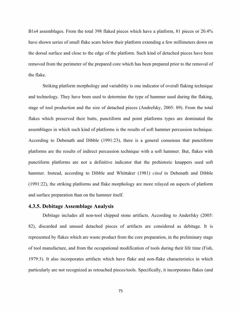
75""
B1s4 assemblages. From the total 398 flaked pieces which have a platform, 81 pieces or 20.4%
have shown series of small flake scars below their platform extending a few millimeters down on
the dorsal surface and close to the edge of the platform. Such kind of detached pieces have been
removed from the perimeter of the prepared core which has been prepared prior to the removal of
the flake.
Striking platform morphology and variability is one indicator of overall flaking technique
and technology. They have been used to determine the type of hammer used during the flaking,
stage of tool production and the size of detached pieces (Andrefsky, 2005: 89). From the total
flakes which preserved their butts, punctiform and point platforms types are dominated the
assemblages in which such kind of platforms is the results of soft hammer percussion technique.
According to Debenath and Dibble (1991:23), there is a general consensus that punctiform
platforms are the results of indirect percussion technique with a soft hammer. But, flakes with
punctiform platforms are not a definitive indicator that the prehistoric knappers used soft
hammer. Instead, according to Dibble and Whittaker (1981) cited in Debenath and Dibble
(1991:22), the striking platforms and flake morphology are more relayed on aspects of platform
and surface preparation than on the hammer itself.
4.3.5. Debitage Assemblage Analysis Debitage includes all non-tool chipped stone artifacts. According to Anderfsky (2005:
82), discarded and unused detached pieces of artifacts are considered as debitage. It is
represented by flakes which are waste product from the core preparation, in the preliminary stage
of tool manufacture, and from the occupational modification of tools during their life time (Fish,
1979:3). It also incorporates artifacts which have flake and non-flake characteristics in which
particularly are not recognized as retouched pieces/tools. Specifically, it incorporates flakes (and

76""
fragments), blades and bladelets (and fragments), burin spalls, cores, outil ecallé, angular waste,
shatters and chips which falls in different size and classes (table 4).
Type N % from the total
assemblage
Debitage 3930 96.8
Whole Flakes 54 1.4
Bipolar Flakes 5 0.1
Flake Fragments 969 24.6
Burin Spalls 17 0.4
Blades 31 0.8
Proximal Blades 38 0.9
Medial Blades 24 0.6
Distal Blades 11 0.3
Debordant Blades 3 0.07
Bladelets 27 0.7
Proximal Bladelets 34 0.9
Medial Bladelets 51 1.3
Distal Baldelets 25 0.6
Angular wastes 1253 31.8
Chips 440 11.1
Shatters 924 23.5
outil ecallé 1 0.02
Cores 23 0.6
Table 5: descriptive analysis of different debitage classes in terms of their number and
percentage
77""
From the total assemblage of B1s4, debitages accounts for 96.8%. This debitage is
dominated by angular wastes which form 30.9% of the total assemblages of B1s4 and 31.8% of
the debitage assemblages. This is followed by flake fragments 24.6% (969 artifacts), shatters
23.5% (924 pieces), chips 11.1% (440 pieces), broken bladelets 2.8% (110 pieces) and broken
blades 1.8% (73 pieces).
Debitage products are important indicators of stage of reduction sequence. Except
primary or initial stage of decortication stage reduction, the other stages of reduction sequences
seemed to be taken place at the site which are reflected by the presence of preparation flakes,
blanks, fragments (may have occurred either during manufacture or use or by trampling), chips,
shatters and discarded angular wastes.
Figure 15: graph shows classes of main debitage from B1s4
4.3.5.1. Cores A total of 23 cores were recognized from B1s4 and this number accounts 0.56% from the
total lithic assemblages. PS1 stratigraphic unit yielded 17 cores and the remaining 2 from the
surface and other 3 cores are PS2 stratigraphic unit. These cores have the mean weight of 12.1g,
0
200
400
600
800
1000
1200
Main"debitage"types"by"number

78""
length of 37.6 mm and mean width of 24.6 mm. The length of the cores ranges from 17.1 to 60.4
(mm) and the dimension of the width ranges from 11.4 to 56.2 (mm). Based on the type and the
manner of flake removal on the surface of the core, the cores from B1s4 are considered as flake,
blade or bladelet cores. From the total 23 cores, 20 or 95.3% are bladelet cores. These cores are
also varies based on the type and number of platforms or the type of striking platforms (Table 5).
Type of Platform Blank Type
N % N %
Single Platform core 14 61 Nodule 9 39.0
Double Platform core 2 8.7 Flake 7 30.5
Bipolar core 3 13 Indeterminate
Opposed double Platform 3 13 Indeterminate 7 30.5
Multiple Platform 1 4.3
Sub total 23 23
Table 6: inventory of platform types and core blank types
These different cores are found in different stage of exploitation which provides
analytical information about the reduction sequence. On their surface, cores show a number of
negative flake scars which are left by the flakes that have been removed. The scar numbers
ranges from 1to 6 with the mean value of 3. Five cores had only 1 scar on the surface. Two cores
had 2 scars, seven cores had 3 scars, six cores had 4 scars, one core had 5 scars and two cores 6
scar numbers. This shows that from the total 23 cores, 14 cores have 3 or less scar umbers on
their on their surface. Despite small number of flakes scars, the majority of the cores are small
which seemed to be found in their late stage of exploitation. The remaining 9 cores have revealed
4 or more flake scar numbers on their surface.

79""
The ripples left by the shock wave provide information to determine in which direction
the flakes was removed. Based on this, four major groups of cores were identified, and each of
these groups is representing a slightly different set of reduction sequence during the removal of
flakes. More than half (14 cores) had single platforms in which flakes were removed from a
single platform. These are single platform non-prismatic cores in which flakes were exploited on
partial face of the cores. This single platform non-prismatic cores accounts for 61 % of the total
core group, followed by opposed double platform and bipolar core each of them form 13% (3
cores each), double platform 8.7%(2 cores), and multiple platform 4.3% (1core) as it has
presented in table 6.

80""
Figure 16: the various core types: 1) Multiple platform core; 2) Single platform Core; 3)
Bipolar Core.
As it has presented in table 5, uni-lateral single platform core dominated B1s4 core
assemblage. The analysis of these cores has shown that they are made in two ways. In one way, a
flake was taken unidirectional from a block fragment/indeterminate piece which has plain (flat)
surface or prepared faceted platform served as the striking surface. 78.5% of single platforms are
bladelet cores and the negatives of their flaking surface shows parallel or sub-parallel scars and
flat (plain) or prepared faceted striking platforms. In the other method, relatively big flake
fragment was chosen and faceted striking platforms were prepared systematically which served
as a striking platform. These cores-on-flakes had yielded small flakes which morphologically fall
on bladelet category. These unilateral-single platforms were identified in different stage of
exploitation which exhibited from 1 to 6 negative flake scar numbers on their flaking surface.
In case of opposed double platform core, flakes are taken on opposed striking platforms.
This is bidirectional exploitation of the flaking surface more or less from parallel striking
platforms at opposite ends served as striking platforms. 3 cores or 13% have opposed double
platform from the total core assemblage. Alike unilateral-single platform cores, the flaking
surface of these cores revealed parallel or sub-parallel small scars. On the other hand, double
Platform Cores from B1s4 do not have opposed platforms. There three double platform cores and
flakes were taken on two different striking platforms which are not found in opposed end. Two
cores have more than two striking platforms and they can be grouped as multiple platform core.
4.3.5.2. Flake and Flake Fragments Flakes and flake fragments include whole flakes (includes also bipolar flakes) and broken
flakes fragment category respectively which all together account for 25.3% of the whole lithic
assemblage. Flake fragments are essentially refers to broken pieces of flakes only and does not

81""
include broken blade and bladelets. It includes proximal flake fragments where still preserve the
platform. It also incorporates medial and distal fragments. From a total 969 flake fragments, 445
are proximal flake fragments. The cause of their breakage is not investigated on this study, but it
may have occurred during production or use. It may occur also because of post depositional
activities.
The majority of these flakes and flake fragments (864 pieces) were discovered from PS1
stratigraphic unit which yielded 84.0% of the collected flakes and flake fragments. PS1
stratigraphic unit produced 116 pieces or 11.2% of flake and flake fragment assemblages. 5
pieces were discovered on the surface and the remaining 43 pieces were collected from the
surface and PS1 stratigraphic unit together as these pieces are found kept in the same bag.
Types N % from the total
flake assemblage
Flakes 54 5.6
Bipolar Flakes 5 0.5
Flake Fragments Proximal Flake 519 53.5
Medial Flake 281 29
Distal Flake 169 17.4
Total 969
Table 7: inventory of Flakes as whole flakes and fragments
The ratio of whole flakes from the total debitage assemblage is low and it accounts only
1.5%. From the total 59 whole flakes, 5 of them are bipolar flakes which all of them were
discovered from PS1 stratigraphic unit. The majority of these whole flakes and proximal flake
fragments have punctiform platform which accounts 73.4%. This was followed by indeterminate
(10.6%), plain platform (7.3%), faceted platform (4.5%) and point platform (4.1%). The length-

82""
breadth- thickness measurement of these whole flakes range from 11 X 5.1 X 1.4 (mm) to 59.9 X
37 X 14.6 (mm), with mean value of 19.6 X 13 X 3.8 (mm) respectively.
4.3.5.3. Blades and Blade fragments As it has been presented in section 2.7, blades and bladelets vary each other on the basis
of metric attributes such as length, width, length/width ratios or combination of all these. Based
on measuring attributes, a total of 34 whole blades and 73 broken blades were recognized from
B1s4. These number account for 0.9% and 1.8% of all the debitage assemblage and 0.8 and 1.8%
of the total lithic assemblage respectively. The length-breadth-thickness measurement value of
whole blades ranges from 26.6 x 10.5 x 2.0 (mm) to 68.8 x 25.2 x 14 (mm) with a mean value
and standard deviation of 40.0 x 14.1 x 5.2 (mm) and 11.9 x 14.1 5.2 respectively. The length-
breadth ratio of blades measures 2.8 mm.
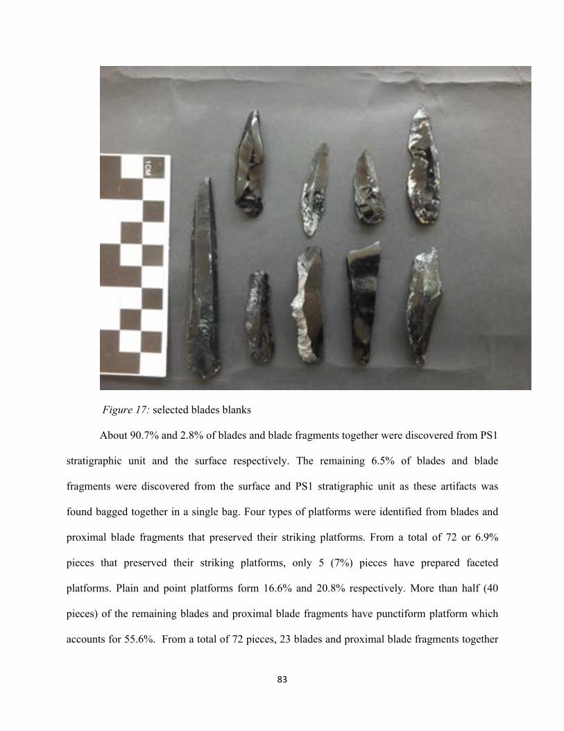
83""
Figure 17: selected blades blanks
About 90.7% and 2.8% of blades and blade fragments together were discovered from PS1
stratigraphic unit and the surface respectively. The remaining 6.5% of blades and blade
fragments were discovered from the surface and PS1 stratigraphic unit as these artifacts was
found bagged together in a single bag. Four types of platforms were identified from blades and
proximal blade fragments that preserved their striking platforms. From a total of 72 or 6.9%
pieces that preserved their striking platforms, only 5 (7%) pieces have prepared faceted
platforms. Plain and point platforms form 16.6% and 20.8% respectively. More than half (40
pieces) of the remaining blades and proximal blade fragments have punctiform platform which
accounts for 55.6%. From a total of 72 pieces, 23 blades and proximal blade fragments together
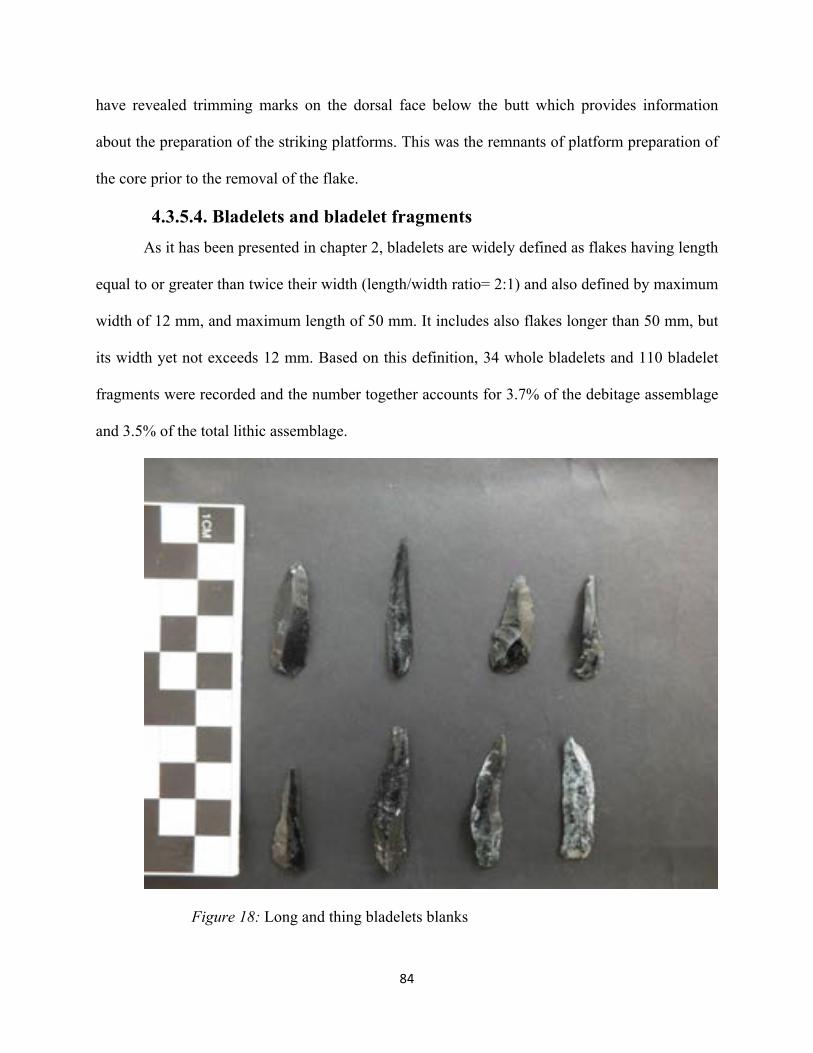
84""
have revealed trimming marks on the dorsal face below the butt which provides information
about the preparation of the striking platforms. This was the remnants of platform preparation of
the core prior to the removal of the flake.
4.3.5.4. Bladelets and bladelet fragments As it has been presented in chapter 2, bladelets are widely defined as flakes having length
equal to or greater than twice their width (length/width ratio= 2:1) and also defined by maximum
width of 12 mm, and maximum length of 50 mm. It includes also flakes longer than 50 mm, but
its width yet not exceeds 12 mm. Based on this definition, 34 whole bladelets and 110 bladelet
fragments were recorded and the number together accounts for 3.7% of the debitage assemblage
and 3.5% of the total lithic assemblage.
Figure 18: Long and thing bladelets blanks

85""
80.3% of these bladelets and their fragments were collected from PS1 stratigraphic unit.
PS2 stratigraphic unit has yielded 10.9% bladelets and bladelet fragments together. The
remaining 8.8% bladelets and their fragments were uncovered on the surface and/or PS2
stratigraphic unit as these artifacts were bagged together in one bag. Whole bladelets and
proximal bladelet fragments which preserve their proximal end have revealed various platforms.
Unlike the blades, prepared faceted platforms were not recorded. Like the blades, punctiforms
are the dominant platforms identified from the bladelets and punctiform platforms account for
67.2%. This was followed by point (26.2%) and plain (6.6%) platforms. Like blades, some of
these bladelets and some proximal fragments have revealed series of small flake scars or
trimmings below the butt or platform on their dorsal face. These distinguished flake scars or
trimmings were prepared prior to the removal of these bladelets. The bladelets and proximal
fragments which have trimming scars below the platform account for 21.3%. The length-breadth-
thickness measurement value of whole bladelets range from 14.1 X 3.8 X 1.2 to 41.7 X 11.7 X
6.9 (mm) with a mean value and standard deviation of 21.6 X 7.7 X 2.3 (mm) and 8.1 X 2.0 X
1.2 respectively. The length-breadth ratio of these bladelets measures 2.8mm.
4.3.5.5. Chips and shattered pieces Chips and shattered pieces are part of the debitage category and they account 10.8 % and 22.8%
of the while lithic assemblage of B1s4. From the total debitage categories, chips and shatters
form 11.2 % and 23.5%. Pieces which grouped as chips are small flakes and according to Butler
(2005:41), chips are by-products of flaking, platform preparation or retouching. Chips exhibit all
characteristic features of flakes. On the other hand, shatters are products of knapping, but they do
not display one or more of the main recognition features of flaked pieces. Finally, chips and
shattered pieces yield diagnostic information that knapping was taking place at the site.

86""
4.3.6. Tools Tools category include detached lithic artifacts that have revealed signs of deliberate
modification on its edges and/or surfaces and also those flaked stone artifacts that shows signs of
modification or edge damage as a result of use. Based on this criteria, B1s4 tools lithic
assemblages includes both shaped/retouched pieces as a result of modification and
unshaped/utilized pieces as a result of use. According Brandt et al (2012) unshaped (informal)
tools are defined as tools which have “minimally invasive edge damage/ retouch (‘utilized’) or
irregular, discontinuous retouch (‘modified’), whereas shaped tools have more invasive having
minimally invasive edge damage/retouch (‘utilized’) or irregular, discontinuous retouch
(‘modified’), whereas shaped tools have more invasive, patterned, and repetitive retouch”. This
modification took place on the thin and long lateral edges and/or distal edges of the flaked
artifacts. These various tool compositions amount to 131 pieces or 3.2% of the total lithic
assemblage. They comprise 77 various retouched and 54 utilized pieces which exhibiting
continuous retouch along their edges.

87""
Type N % from the total tool assemblage
Tools 131
Shaped/ Retouched pieces 77
Backed 6 4.6
Borer 2 1.5
Burin 16 12.2
Microliths 3 2.3
Notched 5 3.8
Retouched 31 23.6
Scraper 14 10.6
Unshaped 54
Utilized Pieces 54 41.2
Table 8: inventory of various tool classes from B1S4.
As it is presented in table 8, shaped tools form 1.9% of the whole analyzed assemblages
of B1s4 and 58.8% of the tool categories. It is composed of 6 backed, 2 borer, 16 burin, 3
microliths, 5 notches, 31 retouched and 14 scraper pieces. On the other hand, all unshaped tools
are composed of only from utilized pieces which form 41.2% of the tools categories and 1.3% of
the total assemblages of B1s4. The most common category of shaped tools is retouched pieces,
which is made up 40.2% of the shaped tools. This is followed by burins and scrapers, which are
formed 20.8% and 18.2% respectively. Other tool classes such as backed tools, borers,
denticulate, microliths and notched pieces form all together the remaining 19.8% of the shaped
tool assemblage.

88""
4.3.6.1. Scrapers (N=14) B1s4 had yielded 14 scrapers which form 18.8% of shaped tools. Flakes and blades were
used as blanks for scrapers which seemed to be elongated blanks were seemed to be preferred for
edge modification. From the total 14 scrapers, 11 of them were collected in PS1 stratigraphic
unit, 1 from the surface and 2 of them were collected in unidentified unit. These scrapers were
found in fresh (11 pieces or 78.6%) and moderately (3 pieces or 21.4%) abrasion conditions.
Typologically, 4 different types of scraper were recognized. These are end scraper, side scraper,
end and side scraper and double end scraper.
Scraper type Total number % from the total scraper
tools
End scraper 10 71.5
Side scraper 1 7.1
End and side scraper 1 7.1
Double end scraper 2 14.3
Total 14 100%
Table 9: different classes of scraper in number and percentage and their blank types
As it has represented in the table 9, the most common type of scraper is single end
scraper which represents 71.5% of the scrapers and 18.2% of shaped tools assemblage. This is
followed by double end scrapers (14.3%), end and side scraper (7.1%) and side scraper (7.1%).
The length-breadth- and thickness measurement ranges from 19.3 x 11.3 x 4.4 (mm) to 58.1 x 35
x 14.5 (mm) with a mean 40.5 x 21 x 7.5 (mm). The length/breadth, length/thickness and
breadth/ thickness ratios have a mean value of 1.9 x 5.4 x 2.8 (mm) respectively.

89""
Figure 19: end scrapers drawing illustration, 1 end scraper on a broken piece and 2 and 3
are ends scrapers on blades
78.6% or 11 scrapers are convex end scrapers when it was viewed from the dorsal
surface. This is followed by 2 straight retouched shape which account for 14.3% and 1 nosed
scraper shape which form 7.1%. Analysis of these scrapers has yielded information that the
makers seemed to prefer to use the distal end of the flakes/blades which have convex distal end.
Only a single side scraper was identified and this scraper had modified edge along the longest
lateral edge. There is a considerable amount of variation in the degree of the scraper angle that

90""
ranges from 43 to 85 degree. Very steep (> 80 degree), steep (60-80 degree) and flat (from 40-60
degree) degree scraper angle was recognized. From the total fourteen scrapers, only one scraper
had a very steep (850) scraper degree angle and the steep scraper accounts for 7.2%. Most
scrapers are dominated by flat scraper degree angle that account for 71.5% of the scraper
assemblage. The remaining two scrapers have revealed steep scraper angle and these scrapers
produced 14.3% of the scraper assemblage. The distribution of the retouch along the edges of
these scrapers is continuous and the extent of the retouch on these scrapers is considered as light
in which the retouch scars were not extended far from the edge. With regards to the position of
retouch, all scrapers display unifacial retouch which is directly took place on the exterior surface
along the distal/ lateral edges flakes/ blades.
4.3.6.2. Use Wear Study of Scrapers In order to understand the function of some tools, use wear study was conducted on a
total of 14 tools (morphologically called scrapers) (see the Appendix) by Elizabeth Peterson who
is a PhD candidate from Simon Frazer University. All the scrapers were recovered from PS1
stratigraphic unit which characterized by ashy fill deposit. According to Peterson (2015) report,
this ashy deposit has protected the tools from most depositional wear (i.e. trampling) and where
thus well situated undergo a use wear study.
Table 10: use wear hardness scale revised from Odell 1979 (after Peterson , 2015).
Hardness(Type Material(TypeAnimal(Soft( Raw(Meat,(Fish,(etc.Vegetable(Soft Plant(Matter1(Medium Wet/(Soften(Hide1(Medium Soft(Wood,(Dry(Hide,(Wet(Bone1(Hard Dry(Bone,(Hard(Wood2(Hard Dry(Antler3(Hard Stone(and(Ground(Earth

91""
The results of this use wear study has yielded that from a total 14 studied tools, 13 of
them were used as either scraping or cutting motion (Table 10). According to Peterson (2015)
report, the most dominant motion was scraping and such kind of motion was indicated by
scraping located on one face of the tools and this motion was identified on 10 tools. Small
feather fractures and medium sized hinged fractures use wear pattern running close to one
another primarily on one face were identified. The type of polish use wear pattern was also
identified and this natty polish found primarily on the opposing face from the flake scars, but
along the used edge. Thus these use pattern indicate the tools were used for working wet/soften
hide (1M-table 9). According to Peterson (2015), previous experimental and ethnographic
research results has suggested that the scrapers may have been used to process soften hide (wet
hide). But, using residual analysis and use of higher power microscope study would help to
identify the use wear pattern more clearly (Table 10).
Figure 20: a. Bulbula scraper showing 1m scraping wear at 60x magnification. b.
Wolayta scraper showing 1m scraping wear at 60X magnification (after Peterson, 2015).
Of the 10 scraping tools, hafting wear was identified on 3 of them. These hafting wear
traces were found located on the opposite end of the tool from the scraping wear. Like, the
scraping wear, the hafting wear was revealed in a form of small feather and some small-medium
92""
sized hinge fractures clumped together and appearing on both faces of the tools. Polish wear was
not recognized. But to understand better, higher magnification should be needed.
Retouching of these 10 scraper tools were conducted before and possible during use. In
southern part of Ethiopia ethnographic study has been conducted on hide workers and the results
of the ethnographic study have provided that the hide workers in order to clean the hide
scarpering, they will retouch the tools, hitting off small flakes from one surface (that of the
opposite of the contact edge).
The other activity identified for the scraper class was cutting. This cutting motion was identified
on 4 tools only and was created during the cutting of some type of soft vegetable or animal
material (Table 9). From the total four tools, only one of these cutting tools was used as scraper.
Based on the study result of Peterson (2015) on these tools, the cutting motion and the type of
material of these tools were indicated by light rounding accompanied by feather flake scares
running along the right lateral edge seen at 40X magnification (figure 21). Attempts have been
done to identify the hafting wear, but it was not recognized on any of these tools during this
primary research.
Figure 21: a. Experimental tool used in a cutting motion on 1V at 50X magnification. b.
Bulbula scraper showing cutting of 1V at 50X magnification.

93""
4.3.6.3. Burins A total of 16 burins, which form 20.8% of the shaped tools were identified. Except one
burin which was collected on the surface, the others were uncovered from PS1 stratigraphic unit.
All burins are made up of either burin on truncation or burin on break. Each group represents
50% of all the burins and these two burin classes seem to be the major pattern of production in
the site. In case of burin on break, the knappers used the broken distal or proximal end as
burinated facets and were removed burins spalls on the lateral edge with one or more blows. The
analyzed burins exhibited flat lateral edges /flat distal ends or burin spall scars on the lateral
edges where burin spalls were removed over it. No burin spall scars are recorded on the dorsal
surfaces of the flakes.
Burin Dimension Minimum Maximum Mean Std. Deviation
Length (mm) 16.1 61.2 30 10.5
Breadth (mm) 5.6 24.3 14 5.0
Thickness (mm) 2.6 10.4 4.7 2.1
Weight (gm) 0.3 6.0 2.3 1.5
Table 11: Descriptive statistics of burin
Morphological dimension of these burins vary considerably as it has presented in table
10. The length-breadth- and thickness measurement ranges from 16.1 x 5.6 x 2.6 (mm) to 61.2 x
24.3 x 10.4 (mm) with a mean value of 30 x 14 x 4.7 (mm) respectively. The length/breadth,
length/thickness and breadth/ thickness ratios have a mean value of 2.1 x 6.4 x 3 (mm)
respectively.
4.3.6.4. Other shaped tools These tools category constitute all together 20.8% of all shaped tools from B1s4. They
include 3 microliths, 2 borers, 2 denticulates, 6 backed pieces and 3 notched pieces. Borers and

94""
denticulates constitute the lowest percentage of all shaped tools in which each of them account
for 2.6% of all shaped tools. This is followed by microlithic and notched pieces which each of
them form 3.8% of all the shaped tools from B1s4.
Figure 22: the graphs represent the frequency of different tool forms
All the microlithic and all notched pieces were discovered from PS1 stratigraphic unit.
Despite backed microliths are often considered as diagnostic markers of LSA culture, only 3
microliths were discovered from B1s4. From these 3 pieces, one of the pieces is curved backed
and the remaining two are straight backed.
6
23
5
0
1
2
3
4
5
6
7
Backed Borer Microliths Notched
Number"of"different"tool"classes
95""
Figure 23: Straight backed pieces from B1s4, bulbula.

96""
Microlithic piece
Dimensions
Minimum Maximum Mean Std.
Deviation
Length (mm) 8.9 12 11.3 2.1
Breadth (mm) 3.5 6.8 4.9 1.6
Thickness (mm) 1.2 3 1.8 1.0
Notched Piece
Dimensions
Length 22 41.2 29.7 7.5
Breadth 10.8 45 22.9 13.5
Thickness 3.8 10.6 6.6 2.7
Backed piece
Dimensions
Length (mm) 17 45.5 28.7 11.8
Breadth (mm) 9 19.5 14.7 3.8
Thickness (mm) 3 6.6 5.0 1.2
Table 12: Descriptive statistics of microliths, notches and backed pieces
As it has presented in the table, the length dimension of microliths varies from 8.9 to 12
(mm) with the mean value 11.3 mm. In the same way, the breadth and thickness dimensions of
microliths varies each other which the morphological dimension of breadth-thickness
measurement ranges from 10.8 x3.8 (mm) with mean value of 6.9 and 2.0 (mm) respectively.
Like the microliths, length-breadth-thickness dimensions of backed pieces are also show
measurement variations that ranges from 17 x 9 x 3 (mm) to 45.5 x 19.5 x 6.6 (mm) with mean
value of 28.7 x 14.7 x 5.0 (mm) respectively.
Notched pieces from B1s4 revealed light concavity on the margin of a flake or a blade.
Out of the five notched pieces, 3 flakes exhibit a single concavity on their lateral edge in which
such kind of retouch is made by a single blow. On the other hand, the remaining two flakes,
exhibit notches which were created by very small and continuous retouch. The length of notched

97""
pieces varies from 22 to 41.2 (mm) with a mean value of 29.7mm. Breadth-thickness dimension
descriptive analysis of the notched tools are also varies from 10.8 x 3.8 (mm) to 45 x 10.6 (mm)
with a mean value of 22.9 mm and 6.6 mm respectively.
4.3.6.5. Utilized tools
During the analysis of B1s4 lithic artifacts, utilized tools are considered as a class of
unshaped tools that reveals evidences of utilization and or modification along their edges. They
are not referring to any lithic artifact that shows evidence of pattered modification in their edge.
According to Nelson (1973: 242 cited in Brandt 1982: 95), unshaped tools are characterized by
casually trimmed (“modified”) edges or casually retouched (“utilized”) edges which are
ubiquitous to most East African LSA industries. Based on this definition, flaked pieces that have
shown trimmed (“modified”) edges or casually retouched (“utilized”) edges are classified as
utilized pieces.
98""
Figure: 24: photo illustration of utilized broken blade fragments.
Utilized flakes form 41.2% of all the tools and 1.3% of the total lithic assemblage from
B1s4. The majority of these utilized pieces were made up of fragments of flake, blade or
bladelets which all together accounts 65.5 % of the total utilized pieces. The remaining utilized
pieces were made up of whole flakes (7.4%), blades (16.7%) and bladelets (7.4%). Length-
breadth and thickness measurement dimensions of these utilized pieces ranges from 10 x 5 x 1.6
(mm) to 107 x 31 x 10.9 (mm) with a mean value of 29 x 12.4 33 (mm) and standard deviation
17.7 x 5.3 1.8 respectively. From the total 54 utilized pieces, 47 (87%) of them were collected
from PS1 stratigraphic unit. The surface and PS2 stratigraphic unit together have yielded the
remaining 7 (13%) of all utilized pieces.

99""
Chapter Five
Discussion and Conclusion
5.1. Lithic reduction sequence analysis
5.1.1. Raw material procurement and site function
Lithic reduction sequences include various stages such as acquisition of raw materials,
core preparation and initial reduction, optional primary trimming, optional secondary trimming,
and finally optional maintenance and modification (Collins, 1975). The first marked stages of
reduction sequence (acquisition of raw materials) are linked to the distribution and availability of
raw materials. This distribution and availability of lithic raw materials play an important role to
understand how humans manufactured, used and reconfigured stone tools (Anderfsky, 2008).
Efforts to locate the raw material sources of B1s4 have been made by the project Late Stone Age
Sequence in Ethiopia. Obsidian chemical analysis was conducted by Khalidi but results are not
available yet (Khalidi et al., in preparation cited in Ménard, 2014). Preliminary results from
survey conducted on the obsidian sources around the Bulbula River (figure 2) and obsidian
samples collected from the excavated materials has shown that the prehistoric inhabitants of
Bulbula exploited the local raw materials which are widely available. Based on Bon and Dessie
field report (2010) the more likely obsidian source for Bulbula sites including B1s4 could be the
Alutu Volcano which is located only a few kilometers away from the site. This primary
observation is supported by the presence of various debitage products on the site such as core
trimming flakes, expedient flakes, unretouched blanks and debris dominating the whole lithic
assemblage which could indicate the inhabitants of B1s4 had an easy access to abundant nearby
raw material sources.
100""
Once the raw materials were obtained from the sources, testing and shaping of the blocks
into rough-outs of optimal shape and transportable size allowed them being carried to the nearby
workshop and/or habituation sites that might took place elsewhere and were subsequently
transported into the site. Primary reduction did not taken place on the camp site. This is
supported by the absence of natural blocks, as well as cortical flakes and flakes with cortical
platforms which indicate initial stages of the reduction sequences did not take place there. This is
further supported by the fact that other production stages which did take place on the site and are
represented by large number of debitage pieces such as shatters and chips, shaped tools, different
types of blanks and discarded cores all together. The presence of all these various types of pieces
proves that the majority of reduction sequences were taken place at the site except initial stage of
reduction.
B1s4 was not only used as lithic production campsite, but it was also an ephemeral
occupation site for Bulbula foragers. This idea is supported by the presence of faunal remains as
well as shaped tools that show traces of use-wear. The analysis of the faunal remains shows that
B1s4 faunal assemblage was dominated by mainly bovid. Among these bovid, only one species
could be identified. It is an extinct species (Damaliscus hypsodon) that is very abundant in the
nearby site of B1s1. Despite detailed investigation has not yet been conducted on B1s4,
preliminary investigation on B1s1 faunal remains, which is very close in time and space to B1s4,
show intentional breakage, traces of burning and spiral-shaped fracture on more than 30% of
long bones which may lead to suggest cooking activity and extraction of bone marrow was
taking place on the site (Lesure, 2013 cited in Habte 2013).
In addition, the discovery of shaped and unshaped tools (which form together 3.2% of the
total lithic assemblage) and finally discarded on the site after use has strengthened the argument

101""
that suggests B1s4 was habituation site. The discovery of tools on the habitation site is an
important source of information to determine the function of the site. But, according to
Anderfsky (2005:210), the association of artifact morphology with artifact function pose
question and does not have fully acceptance by researchers nowadays. Because, correlations
between artifacts form and function is almost universally rejected by ethnographers and
ethnoarchaeologists (Anderfsky, 2005). But, macroscopic variability in the stone tool form can
also provide information to determine the function of the site. In our case, the function of the site
is determined by micro-wear study of the tools. From the total 14 tools (morphologically called
scrapers) which were analyzed by Peterson (2015), traces of use wear were recorded on them. Of
the total 14 tools, 13 were identified as having been used in either a scraping or cutting motion.
Tools with scraping motion wears were used to process soften hide (wet hide). On the other
hand, there are tools which show traces of cutting motion and these tools were used for cutting
some type of soft vegetable or animal material. So, these tools might have been used on the site
and finally discarded there. Therefore, all these evidences provide information that the
prehistoric people at Bulbula (B1s4) had multiple functions such as habitation, knapping
workshop and probably butchery site alike B1s1 (see Habte, 2013). But, no cut marks were
identified on the bones from B1s1 and this absence brings doubt on the importance of butchery
on the site (Lesur, 2013 cited in Habte, 2013).
Habte (2013:81) associated the multi functionality of B1s1 with the harsh environmental
condition that prevailed during the terminal Pleistocene. He argued that the extreme harsh
environmental condition of the terminal Pleistocene could probably limit movement of hunter-
gatherers from their habitation to butchery site and finally could limit themselves to restrained

102""
environments where they undertook multiple tasks. This argument also seems to work for B1s4
where multi-oriented activities took place on the site.
5.1.2. Reduction Sequence
Freehand core reduction method was the most dominant one using single, double, and
multiple platform core types. A single bipolar core and 3 bipolar flakes were identified and the
presence of these cores and flakes indicate that bipolar core reduction method was used at B1s4.
Various core types, from single to multiple-platforms, were recognized and each group
representing slightly different set of reduction sequence. Only one core with cortical platform
was identified and flakes were removed from either plain platforms created by removed flakes or
facetted platforms formed by removing small flakes. The majority of the cores are small in terms
of sizes which results from either over-exploitation or technical choice of the knappers for the
production of small bladelets using small flaked pieces. From the total 23 cores, 20 or 95.3% are
bladelet cores which provide important data to suggest that B1s4 lithic industry was oriented
towards the production of bladelets rather. From these cores, flakes were knapped using from
plain to facetted platforms in which the facetted butt on some of the cores are prepared by
inversely retouched the broken edge knapped pieces. Cores with facetted platform were also
recorded from older Bulbula sites and Ménard et al. (2014) indicate these cores had the
appearance of an inverse truncation. It seems that the reduction sequence took place by keeping
transversal and longitudinal convexities blade and bladelet core morphology as indicated by the
presence of crescented blades, bladelets and flakes with pointed distal ends.
When we relate the source of B1s4 to the reduction stages and the final artifacts, it makes
us to question about it. Despite yet we are waiting the final results, it is argued that B1s4 hunter-
gatherers had an easy access to the abundant raw material sources which are not far from the site.

103""
Sites identified near a raw material sources usually yield abundant cores which have been
discarded in their early stage of reduction sequence. On the opposite at B1s4, the ratio of cores to
flakes is too small and even the available cores are found in an exhausted stage of exploitation or
made from flakes (core-on-flakes). So, the lack of cores on the site in one hand and over-
exploitation of the available cores on the other could tell that easy accessibility and availability
of raw material do not necessarily mean an abundance of cores discarded in their early stage of
reduction sequence. Elston and Kuhn (2002) pointed out that other than distance for access to
raw material source, the mobility of prehistoric society might have been affected by
environmental, social and behavioral motives for procurement of raw material.
Butt morphology variability yields information about the overall flaking techniques and
technology. They are useful indicators to determine the type of hammer used during the flaking,
stage of tool production and the size of detached pieces (Andrefsky, 2005: 89). Butts recorded
from various flaked pieces indicate that hunter-gatherers of B1s4 had practiced various flaking
techniques. Despite the limited number of bipolar flakes and cores identified from the total
assemblage the use of bipolar technique could be identified (figure 16/1). Soft hammer flaking
technique could be also used. From the total flakes which preserved their butts, punctiform and
point platforms types are dominated the assemblages in which such kind of platforms is the
results of soft hammer percussion technique.
5.2. Cultural affinities and chronological place of B1s4 within local and
regional LSA framework
5.2.1. Cultural tradition and chronological sequence
Analysis of the debitage on both unit levels (PS1 and PS2) indicate the presence of
similar features that lead us to assume that B1s4 lithic industry was oriented towards the
104""
production of blades and bladelets. From a techno-typological perspective, there appears to be no
significant change among the two assemblages (PS1 and PS2) except the amount of artifacts in
each level. In fact, the total numbers of artifacts discovered from PS2 stratigraphic unit are too
small to afford a meaningful comparison with PS2 stratigraphic unit. But, the artifacts from both
levels have LSA attributes which are characterized by the presence of blades and bladelets other
than flakes and other kinds of shaped tools (e.g. end scrapers, burins), in which closely
correspond to “Ethiopian Stone Tool Tradition”. The butts of knapped pieces also provide
comparable technical data as plain and punctiform striking platform types are appeared to be the
dominant features at both levels. Therefore, comparative results of these techno-typological data
could confirm that the hunter-gatherers occupied B1s4 have not brought a significant
technological and typological change on lithic production at both levels despite temporal gap
existed between both levels.
The cultural industry B1s4 could be compared to what Brandt (1980: 1982) and Clark
and Williams (1978) are referred as “Ethiopian Blade Tool Tradition”. According to Brandt
(1982), “Ethiopian Blade Tool Tradition” is characterized by six distinct features. The first
distinct feature of this technological tradition is almost exclusive use of obsidian and more rarely
chert as a raw material. This argument works well for B1s4 where all the pieces are made up of
exclusively obsidian artifacts.
Other than the raw material type, according to Brandt (1982) “Ethiopian Blade Tool
Tradition” is also manifested by the use of soft hammer and punch-technique for primary
production of flakes and blades from a single to multiple-platform tabular and prismatic cores.
Of course this argument proposed by Brandt is also supplemented by B1s4 as the butt of the
majority of flakes are either punctiforms or point which provide useful information to suggest

105""
soft hammer or punch technique was practiced to remove thin and long flakes more likely with a
non-prismatic cores. Despite the absence of prismatic cores needs scrutiny investigation, it may
be related to a small sample size of the core assemblage uncovered in B1s4.
“Ethiopian Blade tool tradition” is also represented by the dimension of flake/blade
which flake/blade ratio ranging from 2:1 to 3:1. The metric attributes recorded from blades and
bladelets from B1s4 has shown that they are part of this significant dimensional definition. The
other significant feature of “Ethiopian Blade Tool Tradition” is the proportional lack of shaped
tools component. According to Brandt (1982), shaped tools are dominated by microliths,
endscrapers, and burins, but generally lack outils ecailles and points. These characteristic
features of “Ethiopian Blade Tool Tradition” could be also characteristic feature of B1s4 but
lacks microliths (only three pieces) in B1s4 which may show cultural adaptation and subsistence
strategy shift took place during the Terminal Pleistocene.
5.2.2. Environmental and cultural comparisons
As it has been presented in chapter three, there are limited number of LSA occurrences
which have been reported within Ethiopia and East Africa. Some of these LSA sites in Ethiopia
and East Africa closely correspond to in time and space as well culture with B1s4. Among these
LSA occurrences in Ethiopia only few of them are very close in time with B1s4 and these are
B1s1, DW2s2 and DW2s1 at Bulbula in the Ziway-Shala Basin (Ménard et al., 2014), Aladi
Spring (Gossa et al., 2012; Clark and Williams, 1978); Lake Besaka (Brandt, 1982); K’one
(Kurashina, 1978); Porc Epic; and Laga Oda, (H.Breuil, 1938 cited in Kurashina, 1978;
Kurashina 1978; Brandt, 1986). Some of these sites share strong cultural affinities with B1s4.
Particularly B1s1 in the Bulbula Valley which is characterized by blade technology (Habte,
2013) and “Ethiopian Blade Tool Tradition” at Lake Besaka and other LSA sites in Ethiopia are
106""
closely share significant LSA feature with B1s4 as it has been presented below at this chapter.
Outside Ethiopia, there are LSA sites in the Horn and East Africa somehow correspond in terms
of chronology and technological behavior with B1s4. GvJm19 cultural sequence from Lukenya
Hill in Kenya (Kusimba, 2001) and Mumba Rock in Tanzania (Marks and Conard, 2008; Diez-
Martin et al. 2009) are important LSA sites in East Africa.
Local Comparisons: The paleoenvironmental and chronological data which provide
information about Upper Pleistocene in general and terminal Pleistocene in particular are very
limited in East and the Horn of Africa. One of the site which yielded important
paleoenvironmental and chronological data to elucidate cultural and chronological sequences of
terminal Pleistocene hunter-gatherers came from different localities of Bulbula and Deka Wede
(a tributary of the Bulbula) in the Ziway-Shala Basin. The archaeological sites at Bulbula were
radiocarbon dated by AMS and brought two clusters of dates which are separated by a time gap
corresponding to the LGM. Sites dated to the earliest phase were fallen at the end of MIS 3 or
pre-LGM and these groups include B1s3 and DW1. On the other hand sites at Bulbula and Deka
Wede canyon which are fallen at the later phase dated at the beginning of MIS 1 (Post-LGM) or
the onset of African Humid Period. Post-LGM sites include B1s1 locality dated to the very end
of the Pleistocene at Bulbula locality, and DW2s1and DW2s2 sites dated to the very beginning
of Holocene at Deka Wede locality (table 1). These sites were developed at margins of the lake
and were inhabited by foragers before the last main transgression which was dated to the early
Holocene. These two chronological phases are separated by Younger Dryas, which occurred at
the very end of the terminal Pleistocene (Ménard et al., 2014). Therefore, comparison of B1s4
cultural remains at Post-LGM sites at Bulbula would provide better data to understand the
107""
chronological sequence and paleoenvironment of B1s4 hunter-gatherers during the terminal
Pleistocene.
B1s4 was dated to 14,045-13,755 cal BP in PS1 stratigraphic unit and this phase is very
close in time and space with B1s1 which was marked by more arid condition. The faunal remains
from B1s4, which can provide data to understand paleoenviroment of the region, are limited as
well as highly fragmented. But, faunal remains from B1s4 have similarities with B1s1 which is
dominated bovid remains. Of the bovids, one extinct species (Damaliscus hypsodon) was
identified and this species is particularly very abundant in B1s1 assemblage (dated on two
different levels to 13,443-13214 and 13455-13193 cal BP). This late Pleistocene extinct bovid
species is a dry-adapted species which may help to conclude B1s4 was also more dry during the
occupation of the site (Lesur, 2013 cited in Habte 2013). This argument is also supported by the
abundant paleoenvironmental records that indicates much of the late Upper Pleistocene in East
Africa was colder and drier than at present, temperature being 5.1 to 8.8 °C lower than present
(Coetzee, 1967 cited in Kusimba, 2001: 81) and precipitation being 5.1 to 8.8 °C in the Central
Rift Valley (Gasse and Street, 1978). Fish remains are also absent at B1s4 and which is an
important indicator that the basin was dried when it was occupied by hunter-gathers during the
terminal Pleistocene period. In Ethiopia, this terminal Pleistocene phase was characterized by
cool and dry condition and according to Brandt (1982), this phase extends ca18,000-12,000 uncal
BP at Besaka which is also a characteristic feature of much of Ethiopia and northeastern Africa.
Overlying PS1 main occupation horizon, there is an occupational hiatus of 30 cm thick
intermediary silt. This intermediate phase may be corresponding to other sterile horizons which
are identified in the archaeological sites in Bulbula area and this sterile horizon which is
interbedded between PS1 and PS2 may correspond the Younger Dryas phase which was

108""
recorded in other sites of Bulbula (see Ménard et al., 2014). Above the intermediary silt, there is
15 cm undated abrupt occupation horizon and probably it is the upper most of the Terminal
Pleistocene phase occupied by the hunter-gathers of Bulbula before the onset of the Holocene
phase.
On the other hand, comparing B1s4 to early Holocene sites at Bulbula (DW2s1 and
DW2s2) indicate a strong technological and industrial variability. These two sites very close in
space but relatively far in time in which DW2s2 (dated to 11,800-11,311 cal BP) is slightly older
than DW2s1 (dated to 11,335-11,175 cal BP). DW2s2 lithic production tradition is strongly
marked by small lozenge shaped tanged points which were flaked on bipolar blade core (a core
with two opposing platforms, not by bipolar percussion technique). On the other hand, DW2s1 is
characterized by a microlithic industry the majority of them made on burin spall pieces (see
Ménard et al., 2014: 65) which is almost absent from B1s4. This different industrial traditions
show that notable variability exists between terminal Pleistocene (B1s4 and B1s1) and Early
Holocene (DW2s2 and DW2s1) lithic assemblages collected at different sites in Bulbula.
Despite it was not dated, the probable Holocene phase at B1s4 was marked by 50cm thick
pumice deposit and thick silt formation of the Early Holocene lake deposits which does not
preserve any human cultural remains and faunal assemblages. This phase seem to correspond to
the Holocene phase of other sites in Bulbula studied by Ménard (2014: 55) and based on his
study result, this phase was either not suitable for settlement because of the basin was flooded or
cultural materials were not preserved. "
Alike these two upper most deposits levels, the lower and the oldest deposit level of B1s4
did not yield any cultural or faunal remains. This level was filled with brown colluviums deposit
which probably corresponding to LGM period prevalent also in other sites in Bulbula (see

109""
Ménard et al., 2014) and sites in other parts of Ethiopia (see Brandt, 1982). Ménard (2014: 55)
suggested that the Ziway-Shala Basin during LGM period was filled with thick Pumice deposit
(Amernosa Pumice Member) which did not preserve any cultural remains. The date of this
pumice deposit has not yet been known, but it is ongoing analysis which will help to know the
precise period.
Regional comparison: in addition to the terminal Pleistocene and Early Holocene sites
which were found in Bulbula, there are other terminal Pleistocene LSA sites in Ethiopia that
provide technological and chronological comparison to B1s4. One of these sites is Aladi Springs.
Its LSA occupation horizon was dated to ca. 11 ka BP (Gossa et al., 2012) LSA lithic
assemblages from Aladi spring could be compared to B1s4 assemblages and the technological
and typological investigation reveal that it is oriented towards the production of blades and
bladelets alike B1s4 (See Gossa et al., 2012).
The cultural sequence of B1s4 could also compare to sites which are found in Besaka
what Brandt (1980) and Clark and Williams (1978) are referred as “Ethiopian Blade Tool
Tradition” which we discussed above in this chapter. These characteristic features of “Ethiopian
Blade Tool Tradition” from human occupation period of FeJx2 (dated to 11,400-19,000 BP) site
at Lake Besaka can be characteristic feature of B1s4 except lack of microliths and prismatic
cores in B1s4 lithic assemblage.
The radiometric date of K’one is also correspond with the dates of B1s4. The site yielded
both MSA and LSA assemblages and its LSA deposit was after 14,700 ± 200 BP which
synchronous with the rise in Lake Shala in the Main Ethiopian rift at or after 14,400 BP
(Krushina, 1978; Grove et al., 1975). Despite both B1s4 and K’one were dated to Terminal
Pleistocene and represented by LSA assemblage, they show variability in their lithic

110""
composition. Technologically, B1s4 is oriented towards the production of blades and bladelets
from single to multiple-platforms cores.
Outside Ethiopia, one of the site in East Africa which have a relative close chronology is
Lukenya Hill in Kenya. There are six sites at Lukenya Hill and of the six at least four of them
have levels dated to the terminal Pleistocene period. One of the site which is very close in
chronology with B1s4 is GvJm62 and it was dated to 12,195 ± 330 (radiocarbon date BP) based
on samples taken from 130-140 cm below the datum point. There are also other sites such as
GvJm16, JvJm19 and JvJm22 and dated to 13,150 ± 200 (120-125 cm below the datum), 13,705
± 430 (115-120 cm below the datum), 13,730 ± 430 (190-200 below the datum) respectively. But
these dates are unlikely to be correct, because bones are exposed to modern carbon
contamination from soil carbonate and humic acids, affecting their likely age (Brooks and
Robertshaw, 1990 cited in Kusimba, 2010: 97). Alike B1s4, typologically, scrapers are the
dominate group from the total tool assemblage at Lukenya Hill sites. But unlike B1s4, microliths
are widely identified tool assemblages from Lukenya Hill sites followed by a small member of
burins (Kusimba, 2010).
5.3. Conclusion
Cultural adaptation occurs when changes in all aspects of life such as changes in
technology, organization, ideology and changes in physical environment take place. An adaptive
strategy of the hunter-gathers at B1s4 is expressed by the change of some of shaped tools which
had been widely used at a local and regional scale before and after the terminal Pleistocene.
During the terminal Pleistocene, the environment was more arid and significant tools such as
microliths which were used before were not anymore important at B1s4 as well as B1s1 (see
Habte, 2013). For example at a local scale, comparing B1s4 to Early Holocene sites from

111""
Bulbula (DW2s1 and DW2s2) which provided an important technological and industrial
variability. These two sites very close in space but relatively far in time in which DW2s2 (dated
to 11,800-11,311 cal BP) is slightly older than DW2s1 (dated to 11,335-11,175 Cal BP). This
different industrial traditions shows that notable variability exists between terminal Pleistocene
(B1s4 and B1s1) and Early Holocene (DW2s2 and DW2s1) lithic assemblages collected at
different sites in Bulbula as an adaptive strategy to the environmental change occurred after the
terminal Pleistocene and might have forced the hunter-gathers in sites to develop new adaptive
strategies.
During the terminal Pleistocene, the environment was more arid and significant tools
types such as microliths which were used before the terminal Pleistocene in other sites were not
any more important at B1s4 as well as B1s1 (see Habte, 2013). For example, LSA cultural
sequence at Lake Besaka was dated to both pre- and post- terminal Pleistocene yielded a
considerable amount of microliths which are almost absent in the terminal Pleistocene sequence
of B1s4. Instead the assemblage yielded relatively more scrapers, burins, and unshaped utilized
pieces. According to Habte (2013:88), B1s1 also lacks microliths and yielded instead other
shaped tools such as scrapers .The analysis of B1s4 materials indicate microliths were not
necessarily widespread during the terminal Pleistocene LSA which it corresponds to change in
material culture (hunting gears) or adaptation (hunting strategies).

112""
Appendix
Usewear Report
Bubula
June 2015
Elizabeth Peterson
Usewear Analysis
A small usewear study was conducted upon a selection of shaped obsidian tools classified as different types of scrapers from the site of Bubula (n=14). The goal of this study was to identify the use of the scrapers, complementing the morphological analysis and expanding understanding of the nature of the lithic assemblage for this site.
The usewear study was conducted by PhD Candidate Elizabeth Peterson from Simon Fraser University. Peterson has spent the last three years conducting experimental usewear studies aimed at understanding lithic assemblages from sites found throughout Ethiopia. She has recently finished an ethnoarchaeological usewear study conducted upon the Wolayta hideworkers located in the south of Ethiopia.
Methods
Usewear analysis is the study of the function of tools based on the complex analysis of all traces of use, including macro-deformations, micro-linear traces and polishes. All aspects of wear can be reduced to a twofold change that include: 1) alteration in shape and 2) reduction in volume. Experimental studies have shown that through use, the contact edge of a stone tool will change in form based on the material being worked as well as the motion of use. Wear features observed and tracked include edge scaring (micro flakes), abrasion (rounding), and polish. When taken as a whole, the wear pattern and
location of polish should reveal tool motion and worked material. The type of material being worked is identified through a hardness scale (fig 1).
Low-power use-wear analysis involves using a stereomicroscope with a polarizing external (and with the new digital microscopes, an internal as well) light source and has a magnification power of 10-100X. Most motion can be detected through this form of analysis as well as most worked material types including wet and dry hide, hard wood, and soft animal and vegetable materials. Specific wear features observed using low-power analysis include edge rounding and crushing, shallow edge scarring, striations, and some micro-polish.

113""
Hardness(Type Material(TypeAnimal(Soft( Raw(Meat,(Fish,(etc.Vegetable(Soft Plant(Matter1(Medium Wet/(Soften(Hide1(Medium Soft(Wood,(Dry(Hide,(Wet(Bone1(Hard Dry(Bone,(Hard(Wood2(Hard Dry(Antler3(Hard Stone(and(Ground(Earth
Figure 1: Usewear hardness scale revised from Odell 1979
A total of 14 tools where selected for the analysis based upon their morphological type (i.e. scraper) and their stratigraphic location. All tools where recovered from ashy fill deposits. Such deposits help to contain the tools, providing protection from most post depositional wear (i.e. trampling) and where thus well suited to undergo a usewear study. Past experiments and ethnographic tools where used ascomparisons to aid in the identifying of specific wear patterns and a blind test was conducted to check the skills of the analysis before the study commenced.
The method used within the analysis is the standard low-power usewear method developed by Dr. George Odell (1977). Before evaluation, each stone was washed carefully in water and then lightly bathed in 50% acetone to clear away any hand grease that could be confused as polish under microscopic inspection. The tools were then each evaluated under a stereomicroscope of 6 to 80X magnification, tracking the location, type, and frequency of the different wear attributes.
Results
Of the 14 tools studied, 13 were identified as having been used in either a scraping or cutting motion (Table 1). The most common motion found was that of a scraping motion (indicated by the scaring located on one face of the tool) and identified upon 10 of the tools. The wear pattern typesidentified upon these scrapers (small feather fractures with corresponding medium sized hinged fractures running close to one another primarily on one face) along with the type of polish and its location (matty polish found primarily on the opposing face from the flake scars but along the used edge) indicate the working of a material that falls under 1M (fig 1). Past experimental and ethnographic studies conducted by the analysis suggest that the scrapers may have been used to process soften hide (wet hide), though a high power study and residue analysis could identify this more clearly (fig. 2).

!!"#
a. b.
Figure 2: a. Bubula scraper showing 1m scraping wear at 60x magnification. b. Wolayta scraper showing 1m scraping wear at 60X magnification
Possible hafting wear was also identified upon 3 of the 10 scraping tools. This wear was found located on the opposite end of the tool from the scraping wear and was found in the form of small feather and some small-medium sized hinge fractures clumped together and appearing on both faces of the tool. No polish was identified though highermagnification should be used to further explore this.
All 10 scrapers were identified as having been retouched before and possibly during use. Ethnographic studies have shown that hideworkers in southern Ethiopia, to clean the hide scarpering tools during use, will retouch the tools, hitting off small flakes from one surface (that of the opposite of the contact edge).
A total of 4 tools were identified as having been used in a cutting motion on some type of soft vegetable or animal material (Table 1). Only one of these cutting tools was also identified as having been used as a scraper. The cutting motion and type of material of these tools was indicated by the light rounding accompanied by feather flake scares running along the right lateral edge seen at 40X magnification (fig. 3). Hafting wear was not identified on any of the tools though more research is needed to further explore this.
a. $%# #
Figure 3: a. Experimental tool used in a cutting motion on 1V at 50X magnification. b. Bubula scraper showing cutting of 1V at 50X magnification
Conclusion
b.

115""
The usewear study conducted upon the scrapers form the site of Bubula confirms that 10 of the 14 labeled scrapers where indeed used in a scraping motion. The material primarily being worked by these scrapers was identified as being softened hide (wet hide) confirmed by experimental and experimental studies of obsidian scrapers from southern Ethiopia. The other activity identified for the scraper class was cutting. All except for one of these cutting tools showed now sighs of having been used as a scraper. The possible scraper retouch of which identifies these tools as scrapers morphologically may have come not from retouch or use, but through post-deposited wear and or during the tools manufacturing (crushing and/or platform prep).
Table 1: Usewear data for all scrapers
Abrasion ScarringEU PC ACT WM Rdg Pol Loc L D T S RM Ret Type Artifact=n1 8@1 6 1M MR N D D R FH SM OBSIDIAN D SCRAPER 12 6@7 1 VS LR N D D R FH S= OBSIDIAN N SCRAPER 13 4@5 23 N MR MP B B P FS SM OBSIDIAN N SCRAPER 11 7@2 6 1M MR N D D C FH SM OBSIDIAN D SCRAPER 22 2@6 23 N LR MP B B P FB SM OBSIDIAN N SCRAPER 21 7@2 6 1M MR MP D D R FH SM OBSIDIAN D SCRAPER 32 3@6 23 N LR N B B P FH SM OBSIDIAN N SCRAPER 31 8@1 6 1M LR N D D R FH SM OBSIDIAN D SCRAPER 41 8@1 6 1M LR MP D D R FH SM OBSIDIAN D SCRAPER 51 3@5 6 1M LR N D D C FH SM OBSIDIAN D SCRAPER 62 7@2 2 N LR N B B P FB SM OBSIDIAN D SCRAPER 61 7@2 6 1M MR MP B D R FH SM OBSIDIAN D SCRAPER 71 4@5 6 1M MR MP B D C FH SM OBSIDIAN D SCRAPER 81 5@7 1 AS LR MP B B P F= S= OBSIDIAN N SCRAPER 92 1@4 1 AS LR MP B D R FC SM OBSIDIAN N SCRAPER 93 4@5 23 N LR N D D P F= M OBSIDIAN D SCRAPER 94 8= 0 0 0 0 0 0 0 0 0 OBSIDIAN 0 SCRAPER 91 6@8 1 VS LR N B D R F= S= OBSIDIAN N SCRAPER 102 8@1 6 ? LR N D N N N N OBSIDIAN D SCRAPER 101 4@5 6 1M MR MP B D R FH SM OBSIDIAN D SCRAPER 111 2@4 1 VS LR N D D R F= S= OBSIDIAN N SCRAPER 12N 0 0 N 0 0 0 0 0 0 0 OBSIDIAN 0 SCRAPER 131 8@1 6 1M LR N B V R FH SM OBSIDIAN V SCRAPER 14

!!"## $%&'(#)%%(*+,'-./#0%(#'&&#/)('1.(/#
#

!!"##
#
#

118##
Bibliography
Ambrose S. H., 2001. Paleolithic Technology and Human Evolution. Science Vol.291, 1748-
1753.
Ambrose, S. H., 1998. Chronology of the Later Stone Age and Food Production in East Africa.
Journal of Archaeological Science 25, 377–392.
Ambrose, S. H., 1998. Late Pleistocene human population bottlenecks, volcanic winter, and
differentiation of modern humans. Journal of Human Evolution 34, 623–651.
Ambrose, S. H., 2001. Middle and Later Stone Age Settlement Patterns in the Central Rift,
Kenya: Comparisons and Contrasts. In: Nicholas J. Conard (ed.), Settlement Dynamics of the
Middle Paleolithic and Middle Stone Age. Introductory Volume to the Series: Tiibingen
Publications in Prehistory.
Ambrose, S. H., 2006. Howiesons Poort lithic raw material procurement patterns and the
evolution of modern human behavior: A response to Minichillo (2006). Journal of Human
Evolution 50: 365-369.
Ambrose, S.H., Belfer-Cohen, A., Bleed, P., Close, A., Elston, R., Goebel, T., Goring-Morris,
N., Hiscock, P., Kuhn, S., Neeley, M., Pearson, G., Straus, L., and Yesner, D., 2002. Thinking
Small: Global Perspectives on Microlithization. Archeological Papers of the American
Anthropological Association Number 12, 9-25.
Andrefsky, W., 1997. Thoughts on Stone Shape and Integrated Function. Journal of Middle
Atlantic Archaeology Volume 13: 123-143.
Andrefsky, W., 2005. Lithic Macroscopic Approaches to Analysis, 2nd. ed. Cambridge University
Press, Cambridge.
Andrefsky, W., 2009. The Analysis of Stone Tool Procurement, Production, and Maintenance. J
Archaeol Res 17:65–103.
Barnett, T., 1999. Quiha Rock Shelters, Ethiopia: Implications for Domestication. Azania
XXXIV, pp. 11-24.

119##
Barton, C., Olszewski, D., and Coinman, N., 1996. Beyond the Graver: Reconsidering Burin
Function. Journal of Field Archaeology, Vol. 23, No. 1, pp. 111-125.
Bar-Yosef, O. and Kuhn,S., 1999. The Big Deal about Blades: Laminar Technologies and
Human Evolution. American Anthropologist 101(2):322-338.
Bar-Yosef, O., 2000.The Upper Paleolithicr Evolution. Annual Review of Anthropology, Vol.
31, pp. 363-393.
Baumler, M.F.,1987. Core Reduction Sequence: An Analysis of Blank Production in the Middle
Plaeolithic of North Bosnia, Yugoslavia, Ph.D. Dissertation. The University of Arizona, Tucson.
Benvenuti, M., Carnicelli, S., Belluomini, G., Dainelli, N., Di Grazia, S., Ferrari, G.A., Iasio, C.,
Sagri, M., Ventra, D., Atnafu, B.,and Kebede, S., 2002. Journal of African Earth Sciences 35,
247–269.
Beyene, A., and Abdelsalam, M.G. 2005. Tectonics of the Afar Depression: A review and
synthesis. Journal of African Earth Sciences 41, 41–59.
Bon, F., Dessie, A., Bruxelles, L., Daussy, A., Douze, K., Fauvelle-Aymar, F., Khalidi, L.,
Lesur, J., Ménard, C., Marder, O., Mensan, R., and Saint-Sever, G., 3013. Archeologie
prehistorique de la partie centrale du main Ethiopian Rift (basin lacustre de Ziway-Shala):
contribution a l’etablissement de la s_equence Late Stone Age d'Afrique orientale (LSA
Sequence in Ethiopia). Annales D'Ethiopie XXVIII, 261-297.
Brandt, S., 1980. Archaeological Investigations at Lake Besaka, Ethiopia. In Proceedings of the
8th Panafrican Congress of Prehistory and Quaternary Studies. Nairobi: International Louis
Leaky Memorial Institute for African Prehistory, pp. 339-243.
Brandt, S., 1982. A late Quaternary Cultural-environment Sequence from Lake Besaka,
Southern Afar, Ethiopia. PhD Dissertation, University of California, Berkeley.
Brandt, S., 1986. The Upper Pleistocene and Early Holocene Prehistory of the Horn of Africa.
The African Archaeological Review, 4, pp. 41-82.

120##
Brandt, S., and Brook, G., 1984. Archaeological and Paleoenvironmental Research in Northern
Somalia Current Anthropology, Vol. 25, No. 1, pp. 119-121.
Brandt, S., Fisher, E., Hildebrand, E., Vogelsang, R., Ambrose, S., Lesur, J., and Wang, H.,
2012. Early MIS 3 occupation of Mochena Borago Rockshelter, Southwest Ethiopian Highlands:
Implications for Late Pleistocene archaeology, paleoenvironments and modern human dispersals.
Quaternary International 274: 38-54.
Butler, C. 2005. Prehistoric Flintwork. Tempus Publishing Ltd.
Castaneeda, N., 2009. A Methodological Approach to Core Analysis. Human Evolution, Vol. 24,
no. 2, pp. 107-119.
Clark, D. J., 1954. The Prehistoric Cultures of the Horn of Africa: An Analysis of the Stone Age
Culture and Climatic Succession in Somalilands and Eastern Part of Abyssinia. Cambridge
University Press, Cambridge.
Clark, J.D., 1985. The microlithic industries of Africa: their antiquity and possible economic
implications. In: Misra, V.N., Bellwood, P.S. (Eds.), Recent Advances in Indo-Pacific
Prehistory: Proceedings of the International Symposium Held at Poona, December 19-21, 1978.
Oxford & IBH Pub. Co., New Delhi, pp. 95-103.
Clark, J.D., 1988. The Middle Stone Age of East Africa and the Beginning of Regional Identity.
Journal of World Prehistory, Vol. 2, No 3, 236-305.
Clark, J.D., and Williams, M.A.J., 1978. Recent archaeological research in Southeastern
Ethiopia. 1974-1975. Annales D'Ethiopie 11, 19-44.
Clark, J.D., Williamson, K., Michels, J., and Marean, C., 1984. A Middle Stone Age Occupation
Site at Porc-Epic Cave, Dire Dawa (East-Central Ethiopia). The African Archaeology Review 2,
pp. 37-71.
Clay. R., 1976. Typological Classification, Attribute Analysis, and Lithic Variability. Journal of
Field Archaeology, Vol. 3, No. 3, pp. 303-311.

121##
Close, A., 1978. The Identification of Style in Lithic Artefacts. World Archaeology, Vol. 10, No.
2, Archaeology and Religion, pp. 223-237.
Conard, N., 1990. Laminar Lithic Assemblages from the Last Interglacial Complex in
Northwestern Europe. Journal of Anthropological Research, Vol. 46, No. 3, pp. 243-262.
Conard, N., 2007. Cultural Evolution in Africa and Eurasia during the Middle and Late
Pleistocene. Springer-Verlag Berlin Heidelberg.
Conard, N., Soressi, M, Parkington, J., Wurz, S., and Yates R., 2004. A Unified Lithic
Taxonomy Based on Patterns of Core Reduction. South African Archaeological Bulletin 59
(179): 13–17.
Deacon, H., 1988. The Origins of Anatomically Modren People and the South African Evidence.
Paleoecol Afr 19: 193-200.
Deacon, H., 1995. Two Late Pleistocene –Holocene Archaeological Depositions from the
Southern Cape, South Africa. The South Africa Archaeological Bulletin: 121-131.
Debénath, A., and Dibble, H., 1994. Hand Book of Paleolithic Typology. Lower and Middle
Paleolithic Europe. Upenn Museum of Archaeolgy, Vol. I
Di Paola, G.M., 1972. The Ethiopian Rift Valley (Between 7000’ and 8o40’lat. North). Bull,
Volcanol., 36: 517-560.
Diez-Martín, F., Domínguez-Rodrigo, M., Sánchez, P., Mabulla, A., Tarriño, A., Barba, R.,
Prendergast, M., and Luque, L., 2009. The Middle to Later Stone Age Technological Transition
in East Africa. New Data from Mumba Rockshelter Bed V (Tanzania) and their Implications for
the Origin of Modern Human Behavior. Journal of African Archaeology Vol. 7 (2), pp. 147-173.
Elston, R.G., and S.L. Kuhn, ed. 2002. Thinking Small: Global Perspective on Microlithization.
Amer Anthropological Assn.
Fernández, V., 2007. The Prehistory of the Blue Nile Region (Central Sudan and Western
Ethiopia). Poznan Archaeological Museum, Poznan, pp. 65-98).

122##
Fernández, V., De la torre I., Luque, L., González-ruibal, A., and López-sáez J., 2007 A Late
Stone Age Sequence from West Ethiopia: the Sites of K'aaba and Bel k'urk'umu (Assosa,
Benishangul-Gumuz Regional State). Journal of African Archaeology, Vol. 5 (1), pp 91-126.
Finneran, N., 2003. The prehistoric settlement of the Shire Region, Western Tigray, Ethiopia:
Some preliminary observations. NYAM YKUMA, No. 59, pp.26-31.
Finneran, N., Boardman, S., and Cain, C., 2000. A New Perspective on the Late Stone Age of the
Northern Ethiopian Highlands: Excavations at Anqqer Baahti, Aksum, Ethiopia 1996. Azania:
Archaeological Research in Africa, 35:1, 21-51.
Fish, P.,1979. The Interpretative Potential of Mousterian Debitage. Anthropological Research
Paper no.15. Arizona State University, Tempe.
Fisher, L., 2006. Blades and microliths: Changing contexts of tool production from Magdalenian
to Early Mesolithic in southern Germany. Journal of Anthropological Archaeology 25: 226–238.
Gallagher, J., 1977. Contemporary Stone Tools in Ethiopia: Implications for Archaeology.
Journal of Field Archaeology, Vol. 4, No. 4, pp. 407-414.
Gang, G., 1997. Comparative Analysis of Lithic Materials Recovered from Shurmai (GnJm1)
and Kakwa Lelash (GnJm2) Rockshelters. PhD Dissertation, Texas A and M university.
Gasse, F., 2000. Hydrological changes in the African tropics since the Last Glacial Maximum.
Quaternary Science Reviews 19 (2000) 189-211.
Gasse, F., 2005. Climate and hydrological changes in tropical Africa during the past million
years. Human Palaeontology and Prehistory, 1-9.
Gasse, F., and Street, F.A., 1978. Late Quaternary Lake-Level Fluctuation and Environments of
the Northern Rift Valley and Afar Region (Ethiopia and Djibouti). Palarogeography,
Palaeoclimatology, Plalaeoecology, 24: 279-328.
Gilead, I., 1991. The Upper Paleolithic Period in the Levant. Journal of World Prehistory, Vol.
5, No. 2, pp. 105-154.

123##
Gliganic, L., Jacobs,Z., Roberts, R., Domínguez-Rodrigo, M., and Mabulla , A., 2012. New
ages for Middle and Later Stone Age deposits at Mumba rockshelter, Tanzania: Optically
stimulated luminescence dating of quartz and feldspar grains. Journal of Human Evolution 62:
533-547.
Goodwin.A., and Van Riet Lowe, C., 1929. The Stone Age Culture of South Africa. Annals of
the South African Museum, 27: 1-289.
Gossa, T., Gahle, Y,. and Negash, A., 2002. A reassessment of the Middle and Later Stone Age
Lithic Assemblages from Aladi Spring, Southern Afar Rift , Ethiopia. Azania: Archaeological
Research in Africa 47 (2): 210-222.
Grove, A. T., Street, F. A., and Goudie, A. S., 1975. Former lake levels and climatic change in
the rift valley of southern Ethiopia. The Geographical Journal, Vol. 141, No. 2 , pp. 177-194.
Grove, A.T., and Goudie, A.,1971. Late Quaternary Lake Levels in Rift Valley of Southern
Ethiopia and Elsewhere in Tropical Africa. 1971. Nature Vol. 234. 403-405.
Habte, B., 2013. A Terminal Pleistocene Cultural Sequences from Ethiopia: Lithic Analysis of
B1S4 Site , Bulbula River (Eastern Shewa). M.A. Thesis, Addis Ababa University, Addis Ababa.
Hassan, F. 1977. Holocene Palaeoclimates of Africa. African Archaeological Review, Vol. 14,
No.4, pp. 213-230.
Hiscock, P., Clarkson, C., and Mackay, A., 2011. Big debates over little tools: ongoing disputes
over microliths on three continents. World Archaeology, 43:4, 653-664.
Humphreys, G., 1978. A Preliminary Report of some Late Stone Age occurences in the Lake
Ziway area of the Central Ethiopian Rift Valley In: Annales d'Ethiopie, Volume 11, pp. 45-66.
Inizan, M., Reduron-Ballinger, M., Roche, H., and Tixier, J., 1999. Technology and
Terminology of Knapped Stone. Cercle de Recherches et d'Etudes Préhistoriques Maison de
l'Archéologie et de l'Ethnologie.
Kaufman, D., 1986. A Proposed Method for Distinguishing Between Blades and Bladelets.
Lithic Technology, Vol. 15, No. 1, pp. 34-40.

124##
Kiage, L., and Liu, K., 2006. Late Quaternary paleoenvironmental changes in East Africa: a
review of multiproxy evidence from palynology, lake sediments, and associated records.
Progress in Physical Geography 30 (5), pp. 633–658.
Klein, R., 1983. The Stone Age Prehistory of Southern Africa. Annual Review of Anthropology,
Vol. 12, pp. 25-48.
Klein, R., 1992. The Archeology of Modern Human Origins. Evolutionary Anthropology: Issues,
Views, and Reviews1 (1), pp. 5-14.
Kurashina, H., 1978. An Excavation of Prehistoric Lithic Technology in East-central Ethiopia.
PhD Dissertation, University of California, Berkeley.
Kusimba S., 1999. Hunter–Gatherer Land Use Patterns in Later Stone Age East Africa. Journal
of Anthropological Archaeology 18, 165–200.
Kusimba, S., 2001. The Early Later Stone Age in East Africa: Excavations and Lithic
Assemblages from Lukenya Hill. African Archaeological Review, Vol. 18, No. 2, pp. 77-123.
Kusimba, S., 2005. What Is a Hunter-Gatherer? Variation in the Archaeological Record of
Eastern and Southern Africa. Journal of Archaeological Research, Vol. 13, No. 4,pp. 337-366.
Le Turdu, C., Tiercelin, J., Gibert, E., Travi, Y., Lezzar, K., Richert, J., Massault, M., Gasse, F.,
Bonnefille, R., Decobert, M., Gensous, B., Jeudy, V., Tamrat, E,. Umer, M., Martens, K., and
Atnafu, B., 1999. The Ziway–Shala lake basin system, Main Ethiopian Rift: Influence of
volcanism, tectonics, and climatic forcing on basin formation and sedimentation.
Palaeogeography, Palaeoclimatology, Palaeoecology 150, 135–177.
Leakey L. S. B., 1950. Stone Implements: How They Were Made and Used. The South African
Archaeological Bulletin, Vol. 5, No. 18 , pp. 71-74.
Leaky, L.S.B., 1930. East Africa Past and Present. The Geographical Journal 76 (6): 496-500.
Leaky, L.S.B., 1943. The Industries of the Gorgora Rock Shelter, Lake Tana. Journal of the East
African and Uganda Natural History Society 17: 199-203.

125##
Leplongeon, A., 2014. Microliths in the Middle and Later Stone Age of eastern Africa: New data
from Porc-Epic and Goda Buticha cave sites, Ethiopia. Quaternary International 343: 100-116.
Lombard M., and Parsons, I., 2008. Blade and ladelet function and variability in risk
management during the last 2000 years in the Northern Cape. The South African Archaeological
Bulletin, Vol. 63, No. 187, pp. 18-27.
Mabulla, A., 1996. Middle and Latter Stone Age Land-Use and Lithic Technology in the Eyasi
Basin, Tanzania. PhD Dissertation, University of Florida, Gainesville.
Mackay, A., 2010. The late Pleistocene archaeology of Klein Kliphuis rock shelter, Western
Cape, South Africa: 2006 excavations. South African Archaeological Bulletin 65 (192): 132–147.
Ménard, C., Bon, F., Dessie, A., Bruxelles, L., Douze, K., Fauvelle, F., Khalidi, Lesur, L., and
Mensan, R., 2014. Late Stone Age variability in the Main Ethiopian Rift: New data from the
Bulbula River, Ziway Shala basin. Quaternary International 343: 53-68.
Mitchell, P., 2002. The Organization of Later Stone Age Lithic Technology in the Caledon
Valley, Southern Africa. African Archaeological Review, Vol. 17, No. 3, pp. 141-176.
Moysey, F., 1943. Excavation of a Rock Shelter at Gorgora, Lake Tana, Ethiopia. Journal of the
East African and Uganda Natural History Society 17 (3-4): 196-198.
Negash, A, Alene, M, Brown, F.H., Nash, B.P., Shackley, M.S., 2007. Geochemical sources for
the terminal Pleistocene/early Holocene obsidian artifacts of the site of Beseka, central Ethiopia.
Journal of Archaeological Science 34, 1205-1210.
Newman, J., 1994. The Effects of Distance on Lithic Material Reduction Technology. Journal of
Field Archaeology, Vol. 21, No. 4, pp. 491-501.
Osmaston, H., and Harrison, S., 2005. The Late Quaternary glaciation of Africa: A regional
synthesis. Quaternary International 138–139: 32–54.
Perrott, R. A., and F. A. Street-Perrott., 1982. New evidence for a late Pleistocene wet phase in
northern intertropical Africa. Paleoecology of Africa 14:57–75.

126##
Phillipson, D. W., 2010. The Excavation of Gobedra Rock-shelter, Axum: an Early Occurrence
of Cultivated Finger Millet in Northern Ethiopia. Azania: Archaeological Research in Africa, pp.
53-82.
Phillipson, D.W., 1982. The later stone age in Sub-Saharan Africa. In: Clark, J.D. (Ed.), The
Cambridge History of Africa. From the Earliest Times to C. 500 BC, vol. I. Cambridge
University Press, Cambridge, pp. 410-477.
Phillipson, D., W., 2005. African Archaeology, 3rd. ed. Cambridge University Press, Cambridge.
Phillipson, L., 2009. Lithic Artefacts as a Source of Cultural, Social and Economic Information:
the evidence from Aksum, Ethiopia. Afr Archaeol Rev 26:45–58.
Pleurdeau, D., 2005. Human Technical Behavior in the African Middle Stone Age: The Lithic
Assemblage of Porc-Epic Cave (Dire Dawa, Ethiopia). African Archaeological Review, Vol. 22,
No. 4: 177-197.
Pleurdeau, D., 2005. The Lithic Assemblage Age of the 1975-1976 Excavation of the Porc-Epic
Cave, Dire-Dawa, Ethiopia-Implications for the East African Middle Stone Age. Journal of
African Archaeology Vol. 3 (1), pp. 117-126.
Pleurdeau, D., Hovers, E., Assefa, Z., Asrat, A., Pearson, O., Bahain, J., and Lam, Y.M., 2014.
Cultural change or continuity in the late MSA/Early LSA of southeastern Ethiopia? The site of
Goda Buticha, Dire Dawa area. Quaternary International 343, 117-135.
Rango, G., 2009. Geochemical and Isotopic Composition of Natural Water in the Main
Ethiopian Rift: emphasis on the Study of Source and Genesis of Fluoride. PhD Dissertation,
Università degli Studi di Ferrara, Ferrara.
Rezek, Z., Lin, S., Iovita, R., and Dibble, H., 2011. The relative effects of core surface
morphology on flake shape and other attributes. Journal of Archaeological Science 38, 1346-
1359.
Robertshaw, P., 1984. Archaeology in Eastern Africa: Recent Developments and More Dates.
The Journal of African History, Vol. 25, No. 4, pp. 369-393.
127##
Rose, J., 2004. New Evidence for the Expansion of an Upper Pleistocene Population out of East
Africa, from the Site of Station One, Northern Sudan. Cambridge Archaeological Journal 14:2,
205–216.
Sangen, M., Neumann, K., and Eisenberg, J., 2011. Climate-induced fluvial dynamics in tropical
Africa around the Last Glacial Maximum? Quaternary Research 76, 417–429.
Sassaman, K., 1990. Complex Hunter–Gatherers in Evolution and History: A North American
Perspective. Journal of Archaeological Research, Vol. 12, No. 3, pp. 228-280.
Semaw, S., 2000. The World’s Oldest Stone Artefacts from Gona, Ethiopia: Their Implications
for Understanding Stone Technology and Patterns of Human Evolution Between 2·6–1·5 Million
Years Ago. Journal of Archaeological Science 27, 1197–1214.
Semaw, S., Renne, P., Harris, J., Feibel, C., Bernor, R., Fesseha, N., and Mowbray, K., 1997. 2.5
Million-Years- Old Stone Tools from Gona, Ethiopia. Letters to Nature, pp 333-336.
Semaw, S., Rogers, M., Quade, J., Renne, P., Butler, R., Dominguez-Rodrigo, M., Stout, D.,
Hart, W., Pickering, T., and Simpson, S., 2003. 2.6-Million-year-old stone tools and associated
bones from OGS-6 and OGS-7, Gona, Afar, Ethiopia. Journal of Human Evolution 45: 169–177.
Sollberger, J., and Patterson L., 1976. Prismatic Blade Replication. American Antiquity, Vol.
41, No. 4, pp. 517-531.
Stafford, B., 1977. Burin Manufacture and Utilization: An Experimental Study. Journal of Field
Archaeology, VOL.4. No.2, 235-246.
Steele, T., and Klein, R., 2009. Late Pleistocene Subsistence Strategies and Resource
Intensification in Africa. In: J.-J. Hublin and M.P. Richards (eds.), The Evolution of Hominin
Diets: Integrating Approaches to the Study of Palaeolithic Subsistence, 113–126.
Street, F. A., and Grove A.T., 1976. Environmental and climatic implications of late Quaternary
lake-level fluctuations in Africa. Nature 261, 385-389.
Street, F.A., 1979. Late Quatenary Lakes in the Ziway-Shala Basin, Southern Ethiopia. PhD
Dissertation. Cambridge University, Cambridge.

128##
Street, F.A., and Grove A. T., 1979. Global Maps of Lake-Level Fluctuations since 30,000 yr
B.P. Quaternary Research 12, 83- 118.
Tierney, J. and deMenocal, P. 2013. Abrupt Shifts in Horn of Africa Hydroclimate Since the Last
Glacial Maximum. Science 342, 843-846.
Tomášková, S., 2005. What Is a Burin? Typology, Technology, and Interregional Comparison.
Journal of Archaeological Method and Theory, Vol. 12, No. 2, pp. 79-115.
Umer, M., Legesse, D., Gasse, F., Bonneffille, R., Lamb, H., and Jeng, M., 2004. Late
Quaternary Climate Changes in the Horn of Africa. In: Battarbee, R., Gasse, F. and Stickley
(eds.), Climate Variability through Europe and Africa. Development in Paleoenvironmental
Research Volume 6: 159-179.
Wendorf, F., and Schild, R. 1974. A Middle Stone Age Sequence from the Central Rift Valley,
Ethiopia. Institute of the History of Material Culture, Polska Akademia Nauk, Warsaw.
Wendorf, F., Laury R., Albritton C., Schild, R., Haynes, C., Damon, P., Shafiqullah, M., and
Scarborough, R. 1975. Dates for the Middle Stone Age of East Africa. Science, New Series, Vol.
187, No. 4178, pp. 740-742.
White, R., 1990. Rethinking the Middle/Upper Paleolithic Transition. Current Anthropology,
Vol. 33, No. 1, pp. 85-105.
Whittaker, J.C.,1994. Flintkapping: Making and Understanding of Stone Tools. The University
of Texas press, Austin.
Williams, M., Bishop, P.M., Dakin, F., and Gillespie, R., 1977. Late Quaternary Levels in
Sothern Afar and Adjacent Ethiopian Rift. Nature, 267: 690-93.
WoldeGabriel, G., Aronson,J., and Robert, W., 1990. Geology, geochronology, and rift basin
development in the central sector of the Main Ethiopia Rift. Geological Society of America
Bulletin, 102, no. 4, 439-458.
WoldeGabriel, G., Heiken, G., White, T. D., Asfaw, B., Hart, W. K., and Renne, P. R., 2000,
Volcanism, tectonism, sedimentation, and the paleoanthropological record in the Ethiopian Rift

129##
System. In: McCoy, F. W., and Heiken, G., (eds.), Volcanic Hazards and Disasters in Human
Antiquity: Boulder, Colorado, Geological Society of America Special Paper 345,pp. 83-99.