Massively Reducing Irrigation through Permanent Wireless Below-Ground · PDF...
15
Massively Reducing Irrigation through Permanent Wireless Below-Ground Monitoring Johannes TIUSANEN and Jonathan SKELLY, Finland Key words: Soil Scout, irrigation, wireless, monitoring, water saving SUMMARY It is well-known that water is a precious resource and the ecosystem is broken. Globally, agriculture uses 70% of the available fresh water resources, mostly for crop irrigation. The world average efficiency of agricultural irrigation is about the 50%–60%, mainly due to inappropriate management. Sophisticated irrigation control strategies require near-real-time measurement data on soil moisture. Based on over 15 years of break-through R&D, the Soil Scout HYDRA is the first truly wireless environmental sensor specifically designed to be fully and permanently buried under- ground for up to 20 years, without maintenance. This provides 365x24 insight into below ground conditions, allowing for informed decisions and a potential of reducing water consumption and associated energy costs by up to 50%. A model for calculating the attenuation of a radio link from underground to above ground was developed and validated by case measurements. A patent pending antenna was developed to enable radio transmissions inside soil. The sensing consists of a proprietary capacitive moisture and resistive electric conductivity sensing head developed by Soil Scout and a temperature sensor. Soil Scout Cloud receives data from cellular Soil Scout Base stations, convertes measurements to calibrated data and provides storage, visualisation and analytics. Present irrigation control strategies are not water conservative. Timers are inefficient since the need to avoid wilting requires a margin of over watering. Evapotranspiration models are developed for large scale and estimate poorly micro climate and in-field variation. Until the introduction of Soil Scout, affordable techology for widespread and granular soil condition monitoring has not really existed. The system enables a detailed soil sensor instumentation covering tens - or even hundreds - points of interest at multiple depths. Therefore, new angles into irrigation control strategies are introduced and existing customer cases, involving soil characterization, moisture trending and vertical profiling, presented. The concepts of precision irrigation based on near-real-time soil measurements, and perennial data analysis to maximize water productivity, are presented. Soil Scout is determined to play a key role in providing a feasible and cost effective production system for accurate and information driven farm level water management - which in the end is the most important scene of the whole water supply chain.
Transcript of Massively Reducing Irrigation through Permanent Wireless Below-Ground · PDF...

Massively Reducing Irrigation through Permanent Wireless Below-Ground
Monitoring
Johannes TIUSANEN and Jonathan SKELLY, Finland
Key words: Soil Scout, irrigation, wireless, monitoring, water saving
SUMMARY
It is well-known that water is a precious resource and the ecosystem is broken. Globally, agriculture
uses 70% of the available fresh water resources, mostly for crop irrigation. The world average
efficiency of agricultural irrigation is about the 50%–60%, mainly due to inappropriate
management. Sophisticated irrigation control strategies require near-real-time measurement data on
soil moisture. Based on over 15 years of break-through R&D, the Soil Scout HYDRA is the first
truly wireless environmental sensor specifically designed to be fully and permanently buried under-
ground for up to 20 years, without maintenance. This provides 365x24 insight into below ground
conditions, allowing for informed decisions and a potential of reducing water consumption and
associated energy costs by up to 50%.
A model for calculating the attenuation of a radio link from underground to above ground was
developed and validated by case measurements. A patent pending antenna was developed to enable
radio transmissions inside soil. The sensing consists of a proprietary capacitive moisture and
resistive electric conductivity sensing head developed by Soil Scout and a temperature sensor. Soil
Scout Cloud receives data from cellular Soil Scout Base stations, convertes measurements to
calibrated data and provides storage, visualisation and analytics.
Present irrigation control strategies are not water conservative. Timers are inefficient since the need
to avoid wilting requires a margin of over watering. Evapotranspiration models are developed for
large scale and estimate poorly micro climate and in-field variation.
Until the introduction of Soil Scout, affordable techology for widespread and granular soil condition
monitoring has not really existed. The system enables a detailed soil sensor instumentation covering
tens - or even hundreds - points of interest at multiple depths. Therefore, new angles into irrigation
control strategies are introduced and existing customer cases, involving soil characterization,
moisture trending and vertical profiling, presented. The concepts of precision irrigation based on
near-real-time soil measurements, and perennial data analysis to maximize water productivity, are
presented.
Soil Scout is determined to play a key role in providing a feasible and cost effective production
system for accurate and information driven farm level water management - which in the end is the
most important scene of the whole water supply chain.
Massively Reducing Irrigation through Permanent Wireless Below-Ground Monitoring (9035)
Jonathan Skelly and Johannes Tiusanen (Finland)
FIG Working Week 2017
Surveying the world of tomorrow - From digitalisation to augmented reality
Helsinki, Finland, May 29–June 2, 2017

Massively Reducing Irrigation through Permanent Wireless Below-Ground
Monitoring
Johannes TIUSANEN and Jonathan SKELLY, Finland
1. INTRODUCTION
It is well-known that water is a precious resource and the ecosystem is broken. Globally, agriculture
uses 70% of the available fresh water resources, mostly for crop irrigation. The world average
efficiency of agricultural irrigation is about the 50%–60%, mainly due to the inappropriate
management (UNESCO, 2009).
Most irrigation is still carried out the same way has been done for generations - by eye, or now, by
timer. More sophisticated irrigation control strategies require near-real-time measurement data on
soil moisture, weather parameters, or ideally both. Until now there has been no permanent,
convenient solution for obtaining the soil monitoring data that would enable this industry to
optimise irrigation water use.
Based on over 15 years of break-through R&D, the Soil Scout HYDRA (Fig. 1) is the first wireless
environmental sensor specifically designed to be fully and permanently buried under-ground. The
Scout fits easily in the palm of your hand, and yet transmits through soil, clay, ice, snow and even
stone from up to several metres below ground providing ongoing insight into critical moisture,
temperature and salinity information - for up to 20 years, without maintenance.
Remote sensing and imaging by aerial and satellite equipment have been applied to agricultural
field and crop monitoring, but have not been able to provide detailed information on deeper soil
layer conditions. Existing sensor-based solutions all rely on some form of device sitting on top of
the soil and/or wires running through the subsoil. Thus, soil condition monitoring has not become
routine on many farms. Soil measurement stations are expensive, require maintenance and hinder
regular farming work by introducing obstacles in the field.
Figure 1. Soil Scout HYDRA underground sensor node, Base station and Cloud Service.
Massively Reducing Irrigation through Permanent Wireless Below-Ground Monitoring (9035)
Jonathan Skelly and Johannes Tiusanen (Finland)
FIG Working Week 2017
Surveying the world of tomorrow - From digitalisation to augmented reality
Helsinki, Finland, May 29–June 2, 2017

By being buried, Soil Scout offers out-of-sight permanence. The academic research and system
design were guided by two main criteria; 1) the data packets from underground sensor nodes must
be received with base stations above ground and away from field work, and 2) the maintenance free
underground sensor nodes must operate for more than a decade. This provides farmers 365x24
insight into below ground conditions, allowing them to make informed decisions and thus reach the
potential to reduce water consumption and associated energy costs by up to 50%.
Compared to conventional wired sensors with data loggers, wireless devices are easy to install, they
do not hinder agricultural soil operations and they produce representative data because the
surrounding soil remains undisturbed for several years. The measurement validity is also free of
possible influence from cables, which may conduct surface water into wired sensors especially in
swelling soil types.
This paper will explain the Soil Scout system and discuss how the system can be used for massively
reducing water usage through smart irrigation control.
2. TECHNICAL DESCRIPTION
A model for calculating the attenuation of a radio link from underground (UG) to above ground
(AG) was developed and validated by case measurements (Tiusanen, 2005 and 2007). The
attenuating phenomena of angular defocusing caused by refraction in the soil-air interface was
introduced and verified. The first prototypes of Soil Scouts v1 were installed in 2006 and their data
transfer performance reported (Tiusanen, 2007). A patent pending antenna was developed to enable
radio transmissions inside soil. It is capable of staying tuned despite the soil water content altering a
radio wave length in soil through changing the complex dielectricity of the media. Some early
prototypes were buried in 2006 and are still operating in 2017.
The main challenges for a Wireless Underground Sensor Network (WUSN) concern power
management and connectivity, common problems in wireless sensor networks (WSNs) (Akyildiz &
Stuntebeck, 2006). Solutions in the complicated underground radio environment differ from
terrestrial wireless sensor networks significantly (Sun et al., 2011). Intensive work has been devoted
to evaluate communication in the cases of underground (UG)-to-aboveground (AG) link as well as
underground-to-underground link (UG-UG). Both stationary and mobile network elements have
been considered. Since Soil Scouts only communicate with an AG base station, no actual network is
created and the devices are referred to as wireless underground sensor nodes (WUS) instead of
WUSN. However, the Soil Scout product portfolio does provide solar powered ECHO repeaters,
which can be used to extend the network to any imaginable extent.
The UG-UG channel was eliminated for reasons related to both hardware restrictions and network
topology. Soil Scout development focused on a system, which can monitor a whole agriculture field
without any on-soil in-field instruments. In order to achieve adequate sensor coverage this means
that data from a sensor node must travel several hundred meters to reach the field boundary.
Many reported trials have used wireless soil sensor nodes using an UG sensor and AG transmitter
(Vellidis et al., 2008), applied systems comprised of UG nodes and near-by AG infrastructure nodes
Massively Reducing Irrigation through Permanent Wireless Below-Ground Monitoring (9035)
Jonathan Skelly and Johannes Tiusanen (Finland)
FIG Working Week 2017
Surveying the world of tomorrow - From digitalisation to augmented reality
Helsinki, Finland, May 29–June 2, 2017

acting as repeaters (Ritsema et al., 2009) or have limited the installation depth in order to keep the
soil surface inside the transmitter’s one wavelength (Bogena et al. 2009). These approaches are
applicable in confined environments such as home lawns, but not in open fields where no AG
devices are allowed.
2.1 Radio Wave Attenuation in Soil
Papers related to underground radio signal propagation have incorporated a number of different
attenuating mechanisms. The four mechanisms regarded in Soil Scout development are shown in
Fig. 2. One often disregarded mechanism, when placing an UG transmitter near the soil surface, is
the loss due to angular defocusing LDef. It is a separate phenomenon from the loss due to reflection
from the surface interface LRefl. Soils at different moisture contents have relative permittivity in the
range of 5–45, which retards the travelling speed of electromagnetic radiation, but not the
frequency. Hence the length of an 868 MHz wave in soil is 5–11 cm and a Soil Scout placed 15 cm
deep is located about 1.5–3 wavelengths from the soil surface. The wave striking the soil surface
interface is spherical and the common plane wave approximation does not apply.
Figure 2. Four mechanisms attenuating an UG-AG radiowave: L the loss due to soil medium
attenuation; LRefl due to partial reflection from the surface; LDef due to angular defocusing; and
LPath free air path loss.
The higher the soil water content is, the more electric field power is absorbed by the soil medium,
but the less power is reflected from the soil surface interface. In other words, the loss due to soil
medium attenuation L increases with soil moisture content, but the loss due to partial reflection
LRefl decreases. Thus changes in soil moisture will roughly cause these phenomena to cancel out
changes in each other. However, angular defocusing LDef increases along inclining moisture
content. All four mechanisms have been discussed in detail and validated (Tiusanen, 2009;
Tiusanen, 2007; Tiusanen, 2005).
One topic in addition to soil radio wave interaction must be addressed here. The receiving antenna
significantly affects Soil Scout system performance. The main criterion is antenna directivity, which
corresponds to antenna gain. Just like optics, the stronger the signal amplification in one direction
Massively Reducing Irrigation through Permanent Wireless Below-Ground Monitoring (9035)
Jonathan Skelly and Johannes Tiusanen (Finland)
FIG Working Week 2017
Surveying the world of tomorrow - From digitalisation to augmented reality
Helsinki, Finland, May 29–June 2, 2017

becomes, the narrower the beam from which waves can be intercepted. The beam width is always a
trade off compared to signal strength gain.
2.2 Soil Scout Radio and Power Performance
Soil Scouts employ the license free European 868 MHz or American 915 MHz ISM-band at 500
mW transmitting power, which equals to +27 dBm (decibel of mW). The underground antenna is an
advanced underground antenna, which is small in size and mechanically durable. The present
system is built around a single-chip transceiver micro controller. The measurement and
transmission duty cycle is 20 min and the device is powered by a 2500 mAh 3 V lithium battery.
During the 400 ms sensing and processing phase the current varies between 0.05 and 32 mA and
adds up to 26 nAh per cycle. The time on air for the 10-byte Gaussian frequency-shifting key
modulated packet is 2.4 ms, during which 0.5 A current is drawn resulting in 4 μAh per
transmission. In sleep state the node draws 2.5 μA, resulting in 2.3 μAh per hour.
The mean current 6.9 μA and battery capacity 2500 mAh results in a theoretical life time of 22
years. The battery has a life span exceeding 10-years at 30 μA discharge current, which is 4 times
higher compared to the Soil Scout consumption.
The sensing subsystem consists of a analog-to-digital converter, a proprietary capacitive moisture
and resistive electric conductivity (EC) sensing head developed internally by Soil Scout and a
digital on-board temperature sensor. The sensors and the radio amplifier are powered by a regulated
3.3 V supply. In addition to individual id number and sensor data, Soil Scouts transfer periodically
self diagnostic information containing battery voltage etc., allowing for device health diagnostic.
Tables 1a and 1b display the technical specifications of the Soil Scout system.
Table 1a. Soil Scout HYDRA technical specification
Radio power 27.0 dBm (500 mW)
Frequency 868 / 915 MHz
Battery capacity 2500 mAh, encapsulated primary lithium
Life expectancy Up to 20 years @ 1 cycle / 20 minutes
Typical range Scout Depth Receiver In-Air Distance
10-15 cm 400-900 m
25-30 cm 300-800 m
100-200 cm 10-50 m
Dimensions (L x W x H)
- Scout HYDRA
- Scout FLEX
129 x 59 x 25 mm
78 × 59 × 25 mm
Soil Sensing 3-prong integrated capacitive moisture & resistive salinity
Temperature sensor
(Digital on-board)
Range: -40 to +80°C, accuracy: 0.25 °C
Resolution: -40.0 to -11 1.00°C
-10.0 to +10 0.25°C
+10.5 to +80 0.50°C
Encapsulation Polyurethane
Massively Reducing Irrigation through Permanent Wireless Below-Ground Monitoring (9035)
Jonathan Skelly and Johannes Tiusanen (Finland)
FIG Working Week 2017
Surveying the world of tomorrow - From digitalisation to augmented reality
Helsinki, Finland, May 29–June 2, 2017

Table 1b. Soil Scout Base Station technical specification
Receiver RF sensitivity -100 dBm
Operating Voltage 8-14 VDC, 300 mA
Dimensions (L x W x H) 180 x 130 x 100 mm 4)
Receiver interface Cellular modem / Custom
2.3 Soil Scout Moisture Sensing
Electric soil moisture content sensors are based on measuring how soil interacts with an electric
field. Soil electrical phenomena are complicated, and one single parameter cannot be directly
converted to absolute moisture without using calibration equations. Soil Scout embedded sensors
are software controlled, and are able to address soil behaviour by utilizing several methods and
thereby providing deeper information for moisture content determination.
At modest alternating current frequencies (< 200 MHz), two separate phenomena mainly determine
how soil water responds to an electric field.
Capacitivity: Water molecules are dipoles, so they rotate in an electric field. As the field alternates,
repetitious rotations consume energy, causing the soil to charge and discharge. The amount of
charged energy correlates to the amount of water. In electric circuits, soil appears as a capacitor
with a moisture dependent capacitance.
Conductivity: All ions dissolved in water carry a current; so distilled water is not conductive.
Negative ions flow towards the positive anode, positive ions vice versa. With less water, the route
for these ions to travel in soil becomes more difficult. Hence, electrical conductivity (EC) is
proportional to soil moisture. Note: the level of measured EC is dependent on soil salinity, whilst
changes in conductivity depend on moisture content level.
Figure 3. Soil Scout HYDRA sensing head.
The Soil Scout HYDRA has a 3-prong sensing probe: the centre rod is the active one, and the
adjacent rods are electric ground. All capacitance-sensing elements are embedded inside the
fibreglass board, and have no soil contact. The sensing circuitry induces a short high-frequency
Massively Reducing Irrigation through Permanent Wireless Below-Ground Monitoring (9035)
Jonathan Skelly and Johannes Tiusanen (Finland)
FIG Working Week 2017
Surveying the world of tomorrow - From digitalisation to augmented reality
Helsinki, Finland, May 29–June 2, 2017

signal to the probe and measures the capacitance comprised by the probe and surrounding soil
together.
The apparent capacitance value is a combination of both molecular rotation and ionic conductivity,
as explained above. In the Soil Scout Cloud the value is converted both to a raw dielectric constant
or relative permittivity r and also a volumetric moisture value (kgwater/litersoil). Soil water
permittivity is temperature dependent and the moisture value is temperature compensated based on
the Scout's temperature. The raw dielectric constant value, naturally, remains unaffected by
temperature. Soils may have dielectricity ranging r = 5..40 (dry to wet) and pure water hasr = 80.
All these values are within Soil Scout Hydra scale limits (from dry air to immersed in water).
For the EC measurements, a direct current (DC) resistance measurement is not considered
applicable for soil. The current will remove dissolved ions from the water through electrolysis, and
the sensing elements would corrode and eventually lose soil contact. Soil Scout uses a four-pin
Wenner electrode array with an alternating current at 1000 Hz. The four contact elements are hard
gold plated pads around the probe's outermost prong edges. The prongs are slightly tapered to
provide optimal soil contact when buried.
With a Wenner array, the measurement current is induced to the outermost pins, while the centre
pins sense the voltage gradient. Soil conductivity is a function of both consumed current and
observed voltage. The Wenner method is tolerant to changes in soil contact quality, since the
voltage sensing pins are high-impedance and will not draw current. A four-pin method is superior
compared to simple two-pin resistivity measurements in regards to both robustness and long period
durability, which are essential to a permanently installed device.
In most non-saline sandy soils the capacitance and conductivity are roughly correlated. Therefore,
when strong deviations are observed in the output data, specific soil calibration should be used to
determine a more appropriate moisture equation choice. Over time, the dynamic responses of all
three values towards extreme moisture values can be observed and the moisture equation further
improved.
It is well-known that electric soil moisture sensors are sensitive to 1) changes in the soil temperature
as well as 2) operating voltage. In addition, most inexpensive commercially available and some
more sophisticated sensors require 3) sensor specific calibration (Majonet et al. 2013). Soil Scout
HYDRA has addressed all these problems: 1) Simultaneous moisture and temperature readings are
measured, and the temperature influence cancelled out in the Soil Scout Cloud, 2) the measurement
circuit is powered by a regulated 3.3 V supply, and 3) each Soil Scout HYDRA is calibrated for
production based offset as part of the individual device quality inspection.
3. WATER SAVING IRRIGATION STRATEGIES
There is vast variation in the level of sophistication that present irrigation control systems have. A
rough classification in 3 main approaches is following:
Massively Reducing Irrigation through Permanent Wireless Below-Ground Monitoring (9035)
Jonathan Skelly and Johannes Tiusanen (Finland)
FIG Working Week 2017
Surveying the world of tomorrow - From digitalisation to augmented reality
Helsinki, Finland, May 29–June 2, 2017

1. Timers. Most automated irrigation systems are programmed to irrigate at time intervals for
predefined periods of time. The irrigation schedule is usually based on the user's empirical
knowledge on crop needs.
2. ET models. Crop evapotranspiration (ET) models can be used to estimate the needed irrigation
schedule. ET represents the water lost by soil surface evaporation and crop transpiration. A
corresponding amount of water is applied to refill the soil water content.
3. Soil sensors. The most advanced automatic controllers regulate irrigation based on soil moisture
measurements by initiating irrigation when sensors detect that soil moisture is below a
predefined low level, and halt irrigation if soil moisture exceeds a high limit.
Timers are found as the most inefficient automated control systems in several studies (e.g. Lozoya,
2016; Grabow et al., 2008). The need to proactively prevent plants from wilting, combined to their
inability to react to environmental conditions may cause severe overwatering, causing up to 200 %
water usage.
ET estimate models have been widely applied for water resource and irrigation management, but
only recently have ET models been used for automated real time irrigation control. Several
problems regarding the usability of ET models when applied to small scale have been identified.
For instance, Jiang et al. (1998) measured ET at 6 locations on a golf course and observed that the
individual measured ET values differed from the local weather station referenced ET estimate by
more than 20 %.
In another 1-hectare soil moisture variability study Hupet & Vanclooster (2002) observed that the
soil moisture variability strongly increases in the superficial 0-50 cm layer, mostly due to variability
in the maize crop water uptake. Hence, a generalized ET model is unable to predict irrigation needs
at the level of precision that is required to acheive the water savings potential that irrigation control
offers.
Small scale trials (e.g. Grabow et al. 2008) have proven the massive water saving potential of
controlling irrigation dynamically based on soil sensor data, but there is a lack of experiments
where methods would have been taken to large scale. Until the introduction of Soil Scout,
affordable techology for widespread and granular soil condition monitoring has not really existed.
As sensor networks are fairly novel, only a few studies have been carried out with so-called
wireless sensor networks, in the sense that the sensor hubs communicate wirelessly, although actual
soil sensors are wired to the above ground junction boxes. Most of such studies (such as Li et al.,
2011) have focused on data acquisition without emphasis on validating water saving performance
(Greenwood et al., 2010).
Grabow et al. (2008) compared a timer based, an ET based and two soil sensor based irrigation
control methods on 40 separate 4 m × 4 m turf grass plots. The soil sensor based irrigation
schedules used the least amount of water. In addition, using soil moisture thresholds for both
initiating and terminating irrigation gave the highest turf quality, higher than just initiating
predefined water doses based on a low soil moisture reading.
Massively Reducing Irrigation through Permanent Wireless Below-Ground Monitoring (9035)
Jonathan Skelly and Johannes Tiusanen (Finland)
FIG Working Week 2017
Surveying the world of tomorrow - From digitalisation to augmented reality
Helsinki, Finland, May 29–June 2, 2017

Lozoya et al. delevoped an automated irrigation control strategy that used actual soil sensor
measurements combined to weather condition observations as an integrated control algorithm. The
comparison between four different irrigation control methods for green pepper crop showed that the
integrated control strategy was able to use 67.4 % less water than the timer based control, 40.0 %
less than the ET estimate control, and 14.9 % less water than the soil moisture threshold irrigation
control strategy.
Grabow's moisture level strategy initiated irrigation at 67 % of the Plant Available Water (the
moisture range between Wilting Point and Field Capacity, see Fig. 4) and interrupted just below
Field Capacity. The corresponding moisture content percentages for the sandy loam were 21 % and
30 %, correspondingly. Any added water beyond Field Capacity would suffer from downward
percolation and eventually drain away.
Figure 4. Important soil moisture levels: Wilting Point, Field Capacity and Saturation. The
corresponding moisture content percentages are soil type specific.
4. EXAMPLES OF WATER SAVING POTENTIAL USING SOIL SCOUTS
Because of soil measurement station price, recurrent installation and removal work combined to
field work hindering obstacles, previous irrigation control attempts have been directed towards
using mathematical models to compensate for an inadequate extent of actual measurements. Now
that applying a Soil Scout system enables a detailed soil sensor instumentation covering tens - or
even hundreds - points of interest at multiple depths, completely new angles into irrigation control
strategies can be introduced. They can be described regarding the depth of data usage as follows:
DDrryy SSooiill RReemmaaiinniinngg wwaatteerr iiss
uunnaavvaaiillaabbllee ttoo rroooottss
WWiillttiinngg PPooiinntt
PPllaanntt AAvvaaiillaabbllee WWaatteerr
FFiieelldd CCaappaacciittyy
SSaattuurraattiioonn AAllll ppoorreess aarree ffiilllleedd aanndd
wwaatteerr ppeerrccoollaatteess tthhrroouugghh
Massively Reducing Irrigation through Permanent Wireless Below-Ground Monitoring (9035)
Jonathan Skelly and Johannes Tiusanen (Finland)
FIG Working Week 2017
Surveying the world of tomorrow - From digitalisation to augmented reality
Helsinki, Finland, May 29–June 2, 2017

1. Reacting to momentary moisture values
2. Adjusting irrigation by observing continuous moisture trends
3. Vertical soil profiling by using Scouts at multiple depths
4. Entering spatial precision variable rate irrigation
5. Optimizing water usage through perennial soil moisture and yield recording
4.1 Reacting to momentary moisture values
The first level to applying soil sensor readings is to identify the desired moisture range that should
maintained. There are several sources for defining soil Saturation, Field Capacity and Wilting Point
for different soil types. The most commonly suggested strategy is then to initiate and interrupt
irrigation at 25 % and 75 % of the Plant Available Water (range from Wilting Point to Field
Capacity), respectively. The control can be automated.
A powerful method is to analyse key soil parameters from the dynamic soil data. Saturation is easily
identified as the absolute highest moisture value, where the moisture curve "hits the roof". That is
the theoretical maximum moisture point, where the soil bulk consists only of solid particles and
water (no air). After an irrigation event or heavy rain, the soil rapidly drains to Field Capacity and
the drying is signifigantly slowed down. One example of this method is presented in Fig. 5.
Figure 5. Two month example of agriculture clay soil moisture data shows that the soil is Saturated
at 62 % (maximum level, all pores water filled) and a Field Capacity of 52 % (excessive water has
rapidly drained, slow evaporation begun). Irrigation strategy should aim for not exceeding 50 %,
unless water is intended to percolate into deeper soil layers.
4.2 Continuous moisture level trending
Quite many farmers manage a limited number of irrigated fields and can in fact operate the watering
with skill. However, the guiding principle is to avoid wilting and a resulting crop failure, water use
efficiency being a secondary goal. The operator is forced to maintain a secure margin of over
watering in the lack of insight into the absolute soil moisture conditions.
Massively Reducing Irrigation through Permanent Wireless Below-Ground Monitoring (9035)
Jonathan Skelly and Johannes Tiusanen (Finland)
FIG Working Week 2017
Surveying the world of tomorrow - From digitalisation to augmented reality
Helsinki, Finland, May 29–June 2, 2017
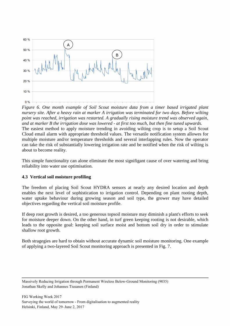
Figure 6. One month example of Soil Scout moisture data from a timer based irrigated plant
nursery site. After a heavy rain at marker A irrigation was terminated for two days. Before wilting
point was reached, irrigation was restarted. A gradually rising moisture trend was observed again,
and at marker B the irrigation dose was lowered - at first too much, but then fine tuned upwards.
The easiest method to apply moisture trending in avoiding wilting crop is to setup a Soil Scout
Cloud email alarm with appropriate threshold values. The versatile notification system allowes for
multiple moisture and/or temperature thresholds and several interlapping rules. Now the operator
can take the risk of substantially lowering irrigation rate and be notified when the risk of wilting is
about to become reality.
This simple functionality can alone eliminate the most signifigant cause of over watering and bring
reliability into water use optimisation.
4.3 Vertical soil moisture profiling
The freedom of placing Soil Scout HYDRA sensors at nearly any desired location and depth
enables the next level of sophistication to irrigation control. Depending on plant rooting depth,
water uptake behaviour during growing season and soil type, the grower may have detailed
objectives regarding the vertical soil moisture profile.
If deep root growth is desired, a too generous topsoil moisture may diminish a plant's efforts to seek
for moisture deeper down. On the other hand, in turf green keeping rooting is not desirable, which
leads to the opposite goal: keeping soil surface moist and bottom soil dry in order to stimulate
shallow root growth.
Both stragegies are hard to obtain without accurate dynamic soil moisture monitoring. One example
of applying a two-layered Soil Scout monitoring approach is presented in Fig. 7.
A
B
Massively Reducing Irrigation through Permanent Wireless Below-Ground Monitoring (9035)
Jonathan Skelly and Johannes Tiusanen (Finland)
FIG Working Week 2017
Surveying the world of tomorrow - From digitalisation to augmented reality
Helsinki, Finland, May 29–June 2, 2017

Figure 7. 20 day example of Soil Scout moisture data from a sport turf USGA specified sand-peat-
mixture with sensors at two depths. The every second day irrigation is adjusted to a rate, where
topsoil is kept at a 20 % moisture level, but no water is allowed to percolate down to the bottom
level. At marker "R" natural rain has occurred, deep soil moisture risen and irrigation events have
been cancelled for 5 days instead of 2.
4.4 Mapping spatial in-field variation and precision irrigation
Precision irrigation (or variable rate irrigation) is a technique allowing producers to apply different
rates of water to different segments of a field. Varying soil type, topography, drainage, multiple
crops or planting dates, and overlap from adjacent pivots are examples of situations where variable-
rate irrigation is needed. Most current center pivot irrigation systems can apply different rates of
water during irrigation by varying speed. However, only the most sophisticated ones can change the
application rate along the length of the pivot. (Vories, 2008)
The obvious difficulty in controlling a precision irrigation boom is to obtain soil moisture data
needed to adjust the irrigation rate accordingly. Center pivot booms may be 400 or even 800 m long
and very tall crops such as corn are often produced. In such fields, even the Soil Scout system
cannot communicate with all in-field sensors directly from outside the field, and another approach
is required.
The preferable setup is to add solar powered Soil Scout ECHO repeaters at all sides of the field in
addition to a few on the boom itself. Scouts on the sides of the field can be used to decide when to
initiate an irrigation event, and as the boom revolves ECHO repeaters are able to collect moisture
data "before and after" the irrigation event. Each event can be used to validate whether the irrigation
threshold was correctly chosen, or some regions had already dried up too much. Simultaneously, the
dosage can be validated based on the "before and after" moisture readings and adjusted accordingly
for the next irrigation events.
R
Massively Reducing Irrigation through Permanent Wireless Below-Ground Monitoring (9035)
Jonathan Skelly and Johannes Tiusanen (Finland)
FIG Working Week 2017
Surveying the world of tomorrow - From digitalisation to augmented reality
Helsinki, Finland, May 29–June 2, 2017

Soil Scouts have been installed successfully in center pivot irrigated fields, but the above described
hybrid method of combining continuous data with on-the-go readings has not yet been put to test in
field trials.
Figure 8. Suggested configuration for a ½ mile (400 m) center pivot irrigated field. Two solar
powered Soil Scout ECHO repeaters are installed; one at the center, another at 300 m from the
center. When the boom is halted as above, all Soil Scouts HYDRA sensors within the red circles are
inside reception range and can be used to decide when to initiate irrigation. As the boom revolves,
all remaining regions are covered with "before-and-after" measurements.
4.5 Perennial soil moisture and yield recording
Recent research in water saving irrigation methods have shown promising potential in accepting a
small or modest cuts in yields while saving enormous amounts of water. In many regions, the
transition from over watering to controlled deficit irrigation may enable the shift from a collapsing
water system to a sustainable water resource management. However, a successful step from the
traditional yield maximizing into optimizing water productivity requires detailed perennial data on
both soil moisture and the consequently produced yields.
Yield mapping is a commercially available technique of using GNSS data during harvest to analyze
crop yield distribution in a given field. The data produces a yield map that can be used to compare
yield distribution within a field from year to year and/or against other known influencing
parameters. (Stafford et el., 1996)
Controlled deficit irrigation has been widely investigated as a valuable and sustainable production
strategy in dry regions. By limiting water applications to drought-sensitive growth stages, this
practice aims to maximize water productivity and to stabilize – rather than maximize – yields.
(Geerts & Raes, 2009)
Massively Reducing Irrigation through Permanent Wireless Below-Ground Monitoring (9035)
Jonathan Skelly and Johannes Tiusanen (Finland)
FIG Working Week 2017
Surveying the world of tomorrow - From digitalisation to augmented reality
Helsinki, Finland, May 29–June 2, 2017
A successful combination of controlling deficit irrigation based on Soil Scout technology and
feeding back the obtained in-field yield variation maps presents a huge opportunity. With the
described method, farmers will be able to perform multiple simultaneous watering strategy trials
within their regular crop production and gradually learn the most favorable strategy not only for
each field, but even for each management zone of their fields.
5. CONCLUSION
We have described the Soil Scout technology for truly underground wireless soil condition
monitoring, the underlying technical principles and the performance specifications of the
commercially available system. Also, we have presented irrigation strategies that have been
successfully employed by our customers worldwide. The most intriguing methods to obtain even
further water savings have been introduced and discussed.
In the end, considering the global water challenge, every farmer inevitably is either a part of the
problem or the solution. We strongly believe that our Soil Scout technology has been the missing
link in providing a feasible and cost effective production system for accurate and information driven
farm level water management - which in the end is the most important scene of the whole water
supply chain.
REFERENCES
Akyildiz, I. F. & Stuntebeck, E. P., 2006, Wireless underground sensor networks: research
challenges, Ad Hoc Networks J. 4, 669-686.
Bogena, H. R., Huisman, J. A., Meier, H., Rosenbaum, U., and Weuthen, A., 2009, Hybrid wireless
underground sensor networks: quantification of signal attenuation in soil, Vadose Zone Journal
8(3), 755-761.
Geerts, S. & Raes, D., 2009, Deficit irrigation as an on-farm strategy to maximize crop water
productivity in dry areas. Agricultural Water Management 96(9), 1275-1284.
Grabow, G.L., Vasanth, A., Bowman, D., Huffman, R.L., Miller, G.L., 2008, Evaluation of
evapotranspiration-based and soil-moisturebased irrigation control in turf. World
Environmental and Water Resources Congress 2008, Honolulu, Hawaii, May 12-16, 2008.
Greenwood, D.J., Zhang, K., Hilton, H.W., Thompson, A.J., 2010, Opportunities for improving
irrigation efficiency with quantitative models, soil water sensors and wireless technology,
Journal of Agricultural Science 2010(148), 1-16.
Hupet, F. & Vanclooster, M., 2002, Intraseasonal dynamics of soil moisture variability within a
small agricultural maize cropped field, Journal of Hydrology 261, 86-101.
Jiang, H., Fry, J.D., Wiest, S.C., 1998, Variability in turfgrass water requirements on a golf course,
HortScience 33(4), 689-691.
Li, Z., Wang, N., Hong, T., Franzen, A., Li, J., 2011, Closed-loop drip irrigation control using a
hybrid wireless sensor and actuator network, Science China 54(3), 577-588.
Lozoya, C., Mendoza, C., Aguilar, A., Román, A., Castelló, R., 2016, Sensor-based model driven
control strategy for precision irrigation,. Journal of Sensors 2016(31), 1-12.
Massively Reducing Irrigation through Permanent Wireless Below-Ground Monitoring (9035)
Jonathan Skelly and Johannes Tiusanen (Finland)
FIG Working Week 2017
Surveying the world of tomorrow - From digitalisation to augmented reality
Helsinki, Finland, May 29–June 2, 2017

Ritsema, C.J.¸ Kuipers, H., Kleiboer, L. van den Elsen, E., Oostindie, K., Wesseling, J.G.,
Wolthuis, J.-W. and Havinga, P.J.M., 2009, A new wireless underground network system for
continuous monitoring of soil water contents, Water resources research 45.
Stafford, J.V., Ambler, B., Lark, R.M., Catt, J., 1996, Mapping and interpreting the yield variation
in cereal crops, Computers and Electronics in Agriculture 14(2-3), 101-119.
Sun, Z., Akyildiz, I. F. and Hancke, G. P., 2011, Dynamic connectivity in wireless underground
sensor networks, IEEE Trans. Wireless Commun. 10(12), 4334-4344.
Tiusanen, J., 2005, Attenuation of a Soil Scout radio signal, Biosystems Engineering 90(2), 127-
133.
Tiusanen, J., 2007, Validation and results of the Soil Scout radio signal attenuation model,
Biosystems Engineering 97, 11-17.
Tiusanen, J., 2009, Wireless soil scout prototype radio signal reception compared to the attenuation
model, Precision Agriculture 10(5), 372-381.
UNESCO, 2009, Water in a Changing World: United Nations World Water Development Report 3,
UNESCO Publishing, Paris, France, 2009.
Vellidis, G., Tucker, M., Perry, C., Kvien, C., Bednarz, C., 2008, A real-time wireless smart sensor
array for scheduling irrigation, Computers and Electronics in Agriculture 61(1), 44-50.
Vories, E.D., 2008, Variable rate irrigation, 14th Annual Judd Hill Cotton Technology Field Day
Tour Book, Trumann, Ark., Judd Hill Field Day Committee.
BIOGRAPHICAL NOTES
Johannes Tiusanen
Founder and Chief Science Officer at Soil Scout Ltd.
PhD Research scientist, speciality in soil science and agriculture electronics
Adjunctive professor in Agrotechnology (University of Helsinki, Finland)
19th generation farmer
Jonathan Skelly
Chief Executive Officer at Soil Scout Ltd.
20+ years in Business Development, Product + Technology Marketing, and Go to Market
Former global head of Product Marketing at Nokia (Phones division)
Extensive international experience and success
Passionate about the Customer, and practical solutions
CONTACTS
CSO, PhD Johannes Tiusanen
Soil Scout Ltd.
Eskolantie 1
00720 Helsinki
FINLAND
Tel. +358 44 3659799
Email: [email protected]
Web site: www.soilscout.com
Massively Reducing Irrigation through Permanent Wireless Below-Ground Monitoring (9035)
Jonathan Skelly and Johannes Tiusanen (Finland)
FIG Working Week 2017
Surveying the world of tomorrow - From digitalisation to augmented reality
Helsinki, Finland, May 29–June 2, 2017