Maps and Satellite Images of Ngorongoro Conservation Area · Maps and satellite images of...
10
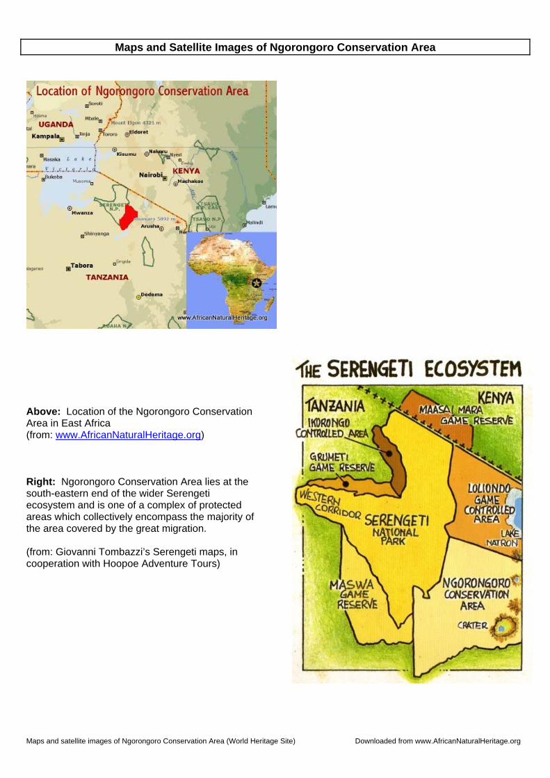
Maps and satellite images of Ngorongoro Conservation Area (World Heritage Site) Downloaded from www.AfricanNaturalHeritage.org Maps and Satellite Images of Ngorongoro Conservation Area Above: Location of the Ngorongoro Conservation Area in East Africa (from: www.AfricanNaturalHeritage.org ) Right: Ngorongoro Conservation Area lies at the south-eastern end of the wider Serengeti ecosystem and is one of a complex of protected areas which collectively encompass the majority of the area covered by the great migration. (from: Giovanni Tombazzi’s Serengeti maps, in cooperation with Hoopoe Adventure Tours)
Transcript of Maps and Satellite Images of Ngorongoro Conservation Area · Maps and satellite images of...
Maps and satellite images of Ngorongoro Conservation Area (World Heritage Site) Downloaded from www.AfricanNaturalHeritage.org
Maps and Satellite Images of Ngorongoro Conservation Area
Above: Location of the Ngorongoro Conservation Area in East Africa (from: www.AfricanNaturalHeritage.org) Right: Ngorongoro Conservation Area lies at the south-eastern end of the wider Serengeti ecosystem and is one of a complex of protected areas which collectively encompass the majority of the area covered by the great migration. (from: Giovanni Tombazzi’s Serengeti maps, in cooperation with Hoopoe Adventure Tours)
Maps and satellite images of Ngorongoro Conservation Area (World Heritage Site) Downloaded from www.AfricanNaturalHeritage.org
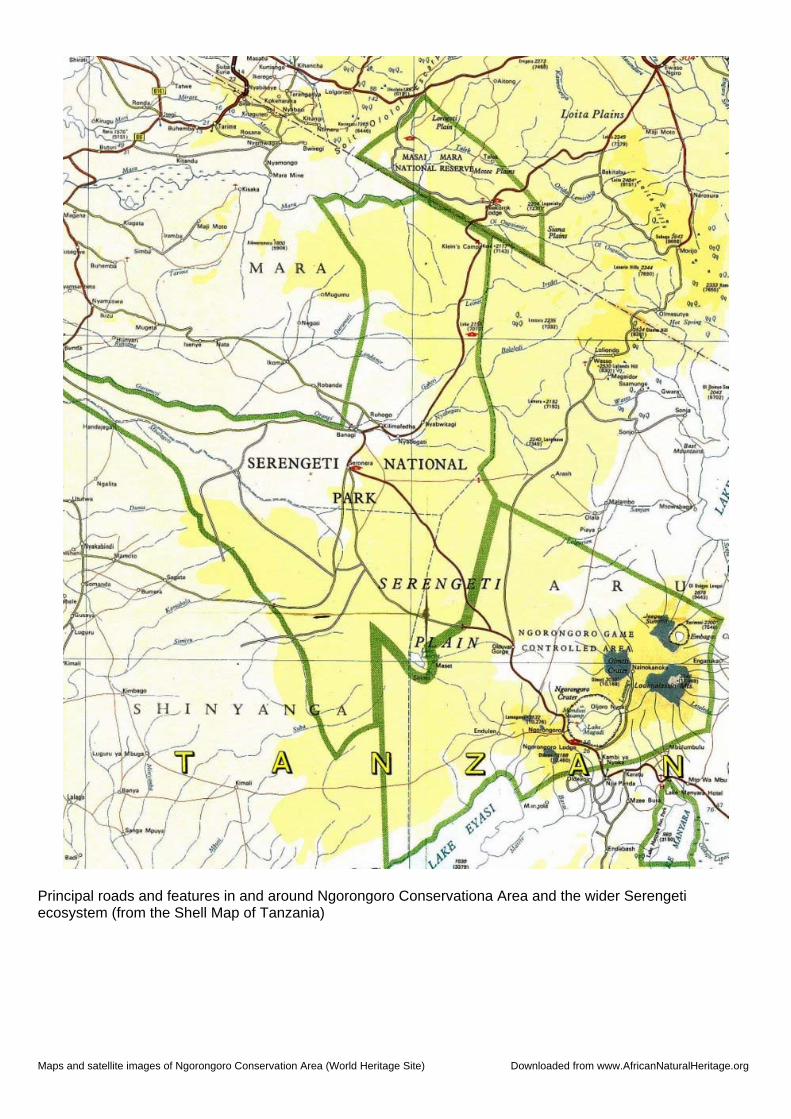
Principal roads and features in and around Ngorongoro Conservationa Area and the wider Serengeti ecosystem (from the Shell Map of Tanzania)
Maps and satellite images of Ngorongoro Conservation Area (World Heritage Site) Downloaded from www.AfricanNaturalHeritage.org
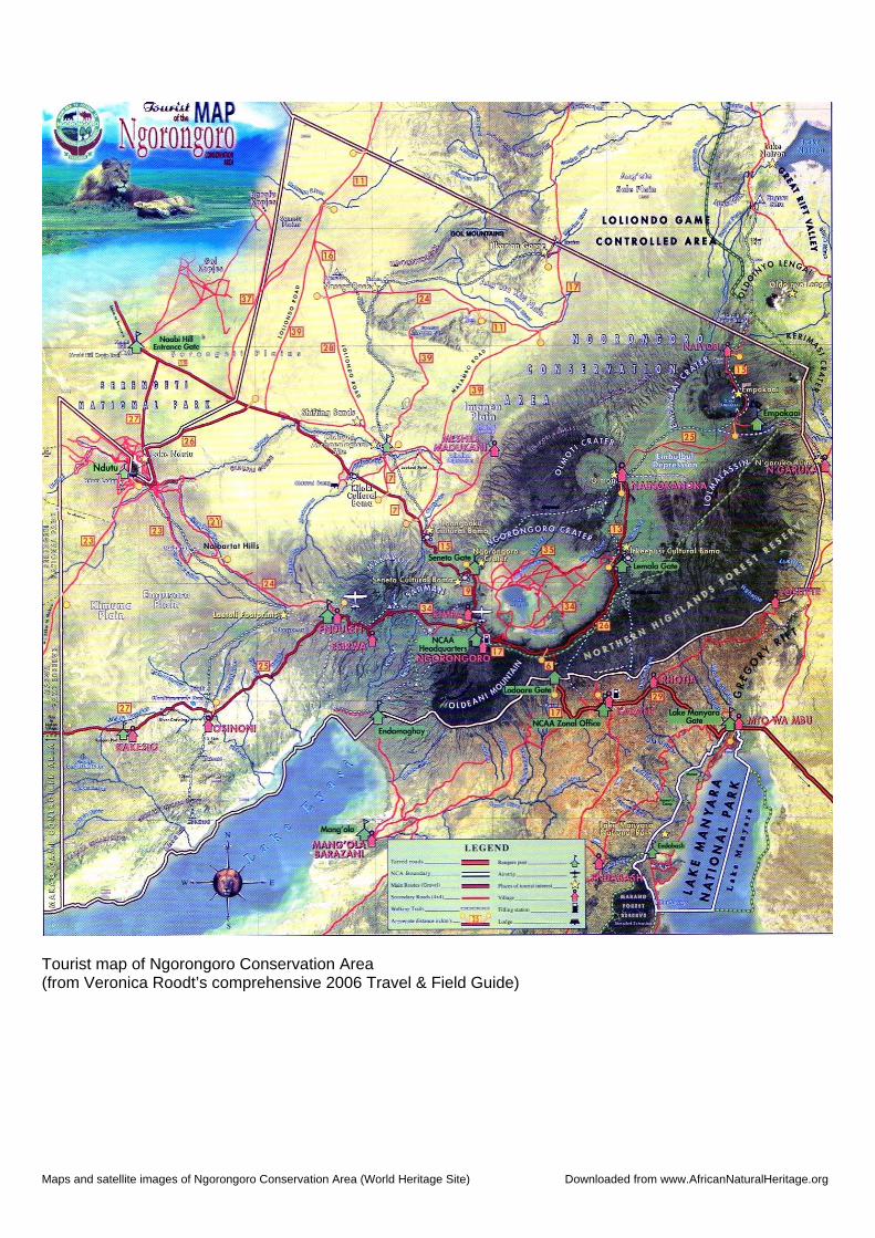
Tourist map of Ngorongoro Conservation Area (from Veronica Roodt’s comprehensive 2006 Travel & Field Guide)
Maps and satellite images of Ngorongoro Conservation Area (World Heritage Site) Downloaded from www.AfricanNaturalHeritage.org
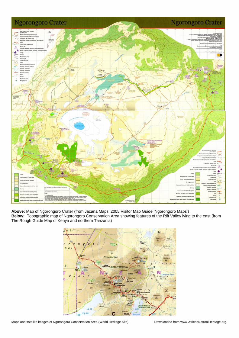
Above: Map of Ngorongoro Crater (from Jacana Maps’ 2005 Visitor Map Guide ‘Ngorongoro Maps’) Below: Topographic map of Ngorongoro Conservation Area showing features of the Rift Valley lying to the east (from The Rough Guide Map of Kenya and northern Tanzania)

Maps and satellite images of Ngorongoro Conservation Area (World Heritage Site) Downloaded from www.AfricanNaturalHeritage.org
Month-by-month movement of the migrating herds through the Serengeti ecosystem (from Giovanni Tombazzi’s Serengeti maps in cooperation with Hoopoe Adventure Tours)

Maps and satellite images of Ngorongoro Conservation Area (World Heritage Site) Downloaded from www.AfricanNaturalHeritage.org
Google Earth satellite image of the short grass plains of southern Serengeti (left half of image), with the rift valley escarpment (Gol Mountains), Lake Natron (top right) and Ngorongoro highlands (bottom right). Lake Ndutu (bottom left) marks the northern boundary of Ngorongoro Conservation Area.
The seven main volcanic cones and craters of Ngorongoro Conservation Area, with Ngorongoro Crater at the centre of the image (Lake Magadi can clearly be seen in the southwestern corner of the crater floor)

Maps and satellite images of Ngorongoro Conservation Area (World Heritage Site) Downloaded from www.AfricanNaturalHeritage.org
Ngorongoro Crater (top right), showing the course of the main road through the conservation area from Arusha/Karatu (off to bottom right) to Seronera in Serengeti National Park (off to top left). To the west (left) of the main road are the volcanic cones of Mounts Lemakarot, Satiman Elgon and Oldeani.
Satellite image of the section of Africa’s Great Rift Valley that lies to the east of the crater highlands. The eastern part of Ngorongoro Conservation Area is shown (bottom of image), together with Lake Natron (left), and the volcanic cones of Mounts Gelai (mid-left) and Kitumbeine (top centre). The active volcano Ol Donyo Lengai lies just outside the conservation area (left of centre, with small white cap)

Maps and satellite images of Ngorongoro Conservation Area (World Heritage Site) Downloaded from www.AfricanNaturalHeritage.org
Satellite image of the eastern part of Ngorongoro Conservation Area showing the perfect cone of lake-filled Empakaai Crater (top left), the cone of Mount Kerimasi (bottom centre, marking the boundary of the conservation area), and Ol Donyo Lengai (God’s Mountain), an active volcano that lies just outside the boundary (bottom right).
Satellite image of Olmoti Crater, an area which is subject to heavy grazing pressure from Maasai cattle, sheep and goats.

Maps and satellite images of Ngorongoro Conservation Area (World Heritage Site) Downloaded from www.AfricanNaturalHeritage.org
Google Earth satellite images showing features of Ngorongoro Conservation Area, with Olkarian Gorge (top); the ash-covered cone of Ol Donyo Lengai (God’s Mountain) which spews ash over the grasslands of Ngorongoro during frequent eruptions (centre); and the arid slopes of Olduvai Gorge, made famous by the fossil hominid discoveries of palaeontologists Louis and Mary Leakey (bottom)

Maps and satellite images of Ngorongoro Conservation Area (World Heritage Site) Downloaded from www.AfricanNaturalHeritage.org
Satellite images of Ngorongoro Crater, showing the intense land pressure on the southern slopes of the caldera where the boundary of the conservation area is marked by a distinct demarcation between protected forest and land cleared for agriculture (top); a lodge perched on the rim of the crater overlooking the zig-zag track that provides access to the crater floor (middle); and game-viewing trails in the mosaic of Acacia woodlands and grassland that characterises the vegetation within the crater (bottom).