Inmarsat Satellite Coverage Maps - Skywave/media/Documents/skyWave/Public/skywave... · Inmarsat...
6
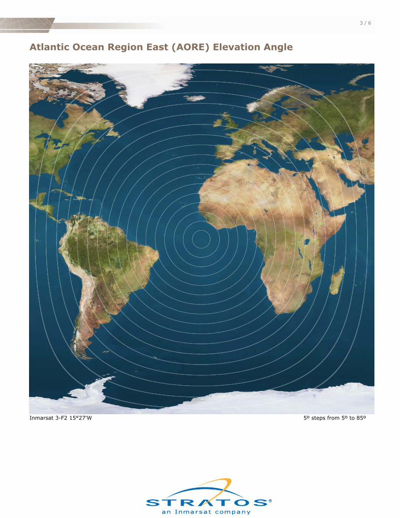
Inmarsat Satellite Coverage Maps - Skywave The maps on the following pages indicate the elevation angle to each of the five Inmarsat satellites used by SkyWave to provide satellite service. The elevation angle is the number of degrees above the horizon that the satellite will appear from a particular location on the globe. Each map has a series of concentric rings centered on a satellite. A ring denotes points on the map which have an equal elevation angle. The outermost ring corresponds with an elevation angle of 5º. Each subsequent ring represents a 5º increment. The innermost ring corresponds to an elevation angle of 85º. Higher elevation angles correspond to stronger signal strength and less likelihood of signal obstruction. These factors are most important when using the DMR or SureLinx terminal for mobile applications.
Transcript of Inmarsat Satellite Coverage Maps - Skywave/media/Documents/skyWave/Public/skywave... · Inmarsat...

Inmarsat Satellite Coverage Maps - Skywave The maps on the following pages indicate the elevation angle to each of the five Inmarsat satellites used by SkyWave to provide satellite service. The elevation angle is the number of degrees above the horizon that the satellite will appear from a particular location on the globe. Each map has a series of concentric rings centered on a satellite. A ring denotes points on the map which have an equal elevation angle. The outermost ring corresponds with an elevation angle of 5º. Each subsequent ring represents a 5º increment. The innermost ring corresponds to an elevation angle of 85º. Higher elevation angles correspond to stronger signal strength and less likelihood of signal obstruction. These factors are most important when using the DMR or SureLinx terminal for mobile applications.

Atlantic Ocean Region West (AORW) Elevation Angle
Inmarsat 3-F4 53°56'W 5º steps from 5º to 85º
3 / 6
Atlantic Ocean Region East (AORE) Elevation Angle
Inmarsat 3-F2 15°27'W 5º steps from 5º to 85º

4 / 6
Indian Ocean Region (IOR) Elevation Angle
Inmarsat 3-F1 63°51'E 5º steps from 5º to 85º

5 / 6
Pacific Ocean Region (POR) Elevation Angle
Inmarsat 3-F3 178°3’E 5º steps from 5º to 85º

6 / 6
Pacific Ocean Region Central (PACC) Elevation Angle
Inmarsat 3-F4 142°’W 5º steps from 5º to 85º