
Map Scale Detail Comparison Graphic Ver. 1 - West Point Scale Detail Comparison Graphic Ver. 1...
1
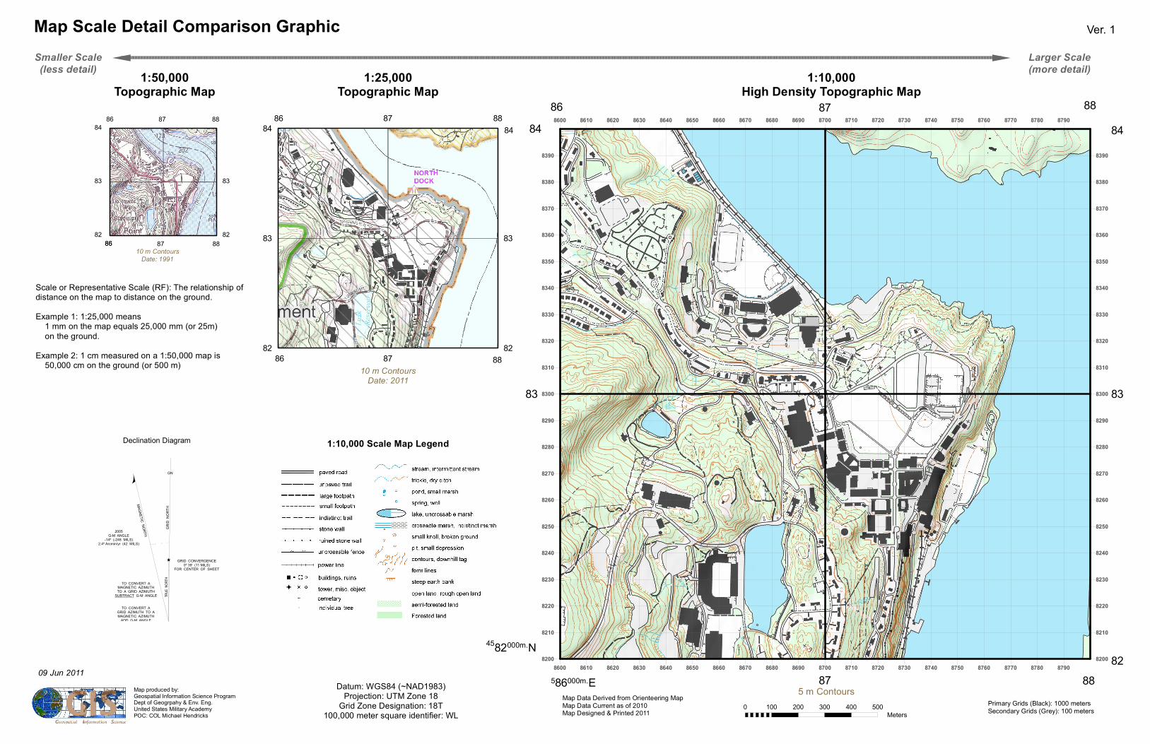
8600 8600 8610 8610 8620 8620 8630 8630 8640 8640 8650 8650 8660 8660 8670 8670 8680 8680 8690 8690 8700 8700 8710 8710 8720 8720 8730 8730 8740 8740 8750 8750 8760 8760 8770 8770 8780 8780 8790 8790 8200 8200 8210 8210 8220 8220 8230 8230 8240 8240 8250 8250 8260 8260 8270 8270 8280 8280 8290 8290 8300 8300 8310 8310 8320 8320 8330 8330 8340 8340 8350 8350 8360 8360 8370 8370 8380 8380 8390 8390 0 100 200 300 400 500 Meters Map Scale Detail Comparison Graphic Ver. 1 Datum: WGS84 (~NAD1983) Projection: UTM Zone 18 Grid Zone Designation: 18T 100,000 meter square identifier: WL Primary Grids (Black): 1000 meters Secondary Grids (Grey): 100 meters 5 m Contours Map produced by: Geospatial Information Science Program Dept of Geogrpahy & Env. Eng. United States Military Academy POC: COL Michael Hendricks Map Data Derived from Orienteering Map Map Data Current as of 2010 Map Designed & Printed 2011 1:10,000 Scale Map Legend 87 87 88 82 82 83 83 84 1:10,000 High Density Topographic Map 1:25,000 Topographic Map 1:50,000 Topographic Map 87 87 45 82 000m. N 83 83 84 82 84 88 86 88 5 86 000m. E 86 10 m Contours Date: 1991 10 m Contours Date: 2011 86 86 88 84 × TRUE NORTH GN GRID CONVERGENCE 0º 39' (11 MILS) FOR CENTER OF SHEET GRID NORTH Ø 2005 G-M ANGLE -14º (-248 MILS) 2.4º Arcmin/yr (42 MILS) MAGNETIC NORTH TO CONVERT A MAGNETIC AZIMUTH TO A GRID AZIMUTH SUBTRACT G-M ANGLE TO CONVERT A GRID AZIMUTH TO A MAGNETIC AZIMUTH ADD G-M ANGLE Declination Diagram Smaller Scale (less detail) Larger Scale (more detail) Scale or Representative Scale (RF): The relationship of distance on the map to distance on the ground. Example 1: 1:25,000 means 1 mm on the map equals 25,000 mm (or 25m) on the ground. Example 2: 1 cm measured on a 1:50,000 map is 50,000 cm on the ground (or 500 m) 87 87 88 82 82 83 83 84 88 86 86 " " 09 Jun 2011
Transcript of Map Scale Detail Comparison Graphic Ver. 1 - West Point Scale Detail Comparison Graphic Ver. 1...
8600
8600
8610
8610
8620
8620
8630
8630
8640
8640
8650
8650
8660
8660
8670
8670
8680
8680
8690
8690
8700
8700
8710
8710
8720
8720
8730
8730
8740
8740
8750
8750
8760
8760
8770
8770
8780
8780
8790
87908200 8200
8210 8210
8220 8220
8230 8230
8240 8240
8250 8250
8260 8260
8270 8270
8280 8280
8290 8290
8300 8300
8310 8310
8320 8320
8330 8330
8340 8340
8350 8350
8360 8360
8370 8370
8380 8380
8390 8390
0 100 200 300 400 500Meters
Map Scale Detail Comparison Graphic Ver. 1
Datum: WGS84 (~NAD1983)Projection: UTM Zone 18
Grid Zone Designation: 18T100,000 meter square identifier: WL
Primary Grids (Black): 1000 metersSecondary Grids (Grey): 100 meters
5 m ContoursMap produced by:Geospatial Information Science ProgramDept of Geogrpahy & Env. Eng.United States Military AcademyPOC: COL Michael Hendricks
Map Data Derived from Orienteering MapMap Data Current as of 2010Map Designed & Printed 2011
1:10,000 Scale Map Legend
87
87
88
82 82
83 83
84
1:10,000High Density Topographic Map
1:25,000Topographic Map
1:50,000Topographic Map
87
87
4582000m.N
83 83
84
82
848886
88586000m.E
8610 m Contours
Date: 1991
10 m ContoursDate: 2011
86
86
88
84
×
TRUE
NOR
TH
GN
GRID CONVERGENCE0º 39' (11 MILS)
FOR CENTER OF SHEET
GRID
NOR
TH
Ø
2005G-M ANGLE
-14º (-248 MILS)2.4º Arcmin/yr (42 MILS)
MAGNETIC NORTH
TO CONVERT AMAGNETIC AZIMUTHTO A GRID AZIMUTH
SUBTRACT G-M ANGLE
TO CONVERT AGRID AZIMUTH TO AMAGNETIC AZIMUTH
ADD G-M ANGLE
Declination Diagram
Smaller Scale(less detail)
Larger Scale(more detail)
Scale or Representative Scale (RF): The relationship of distance on the map to distance on the ground.Example 1: 1:25,000 means 1 mm on the map equals 25,000 mm (or 25m) on the ground.Example 2: 1 cm measured on a 1:50,000 map is 50,000 cm on the ground (or 500 m)
87
87
88
82 82
83 83
84
8886
86
" "09 Jun 2011


![NUC920ABN data sheet Ver A3[1] - Nuvoton · The following integrated on-chip functions are described in detail in this document. Main Function CPU ...](https://static.fdocuments.in/doc/165x107/5d663e4a88c9937a098b9ce5/nuc920abn-data-sheet-ver-a31-the-following-integrated-on-chip-functions.jpg)


