Forever Living Katalog 2016 in Bahasa - Malaysia, Singapore & Brunei

Unlimited distribution
Cleared for public release
A CNA Occasional Paper Malaysia and Brunei: An Analysis of their Claims in the South China Sea
J. Ashley Roach With a Foreword by CNA Senior Fellow Michael McDevitt
August 2014

Copyright © 2014 CNA
This document contains the best opinion of the authors at the time of issue. It does not necessarily represent the opinion of the sponsor.
Cover Photo: South China Sea Claims and Agreements. Source: U.S. Department of Defense’s Annual Report on China to Congress, 2012.
Distribution
Distribution unlimited. Specific authority contracting number: E13PC00009.
Copyright © 2014 CNA This work was created in the performance of Contract Number 2013-9114. Any copyright in this work is subject to the Government's Unlimited Rights license as defined in FAR 52-227.14. The reproduction of this work for commercial purposes is strictly prohibited. Nongovernmental users may copy and distribute this document in any medium, either commercially or noncommercially, provided that this copyright notice is reproduced in all copies. Nongovernmental users may not use technical measures to obstruct or control the reading or further copying of the copies they make or distribute. Nongovernmental users may not accept compensation of any manner in exchange for copies. All other rights reserved.
This project was made possible by a generous grant from the Smith Richardson Foundation
Approved by: August 2014
Ken E. Gause, Director International Affairs Group Center for Strategic Studies

i
Foreword This is the second of three legal analyses commissioned as part of a project entitled, “U.S. Policy Options in the South China Sea.” The objective in asking experienced U.S international lawyers, such as Captain J. Ashley Roach, Judge Advocate General’s Corps, USN (ret.),1 the author of this analysis, is to provide U.S. policy makers access to work that tests the legal arguments that Vietnam, China, Malaysia and Brunei and the Philippines make in support of their claims, weigh them against the body of international case law associated with maritime disputes of this sort, and if possible, reach a judgment on which country’s claim is superior. Importantly, this analysis of Malaysian and Brunei claims in the Spratly archipelago was not undertaken as a prelude to a recommendation that the United States depart from its long held position of not taking a position on competing sovereignty claims in the South China Sea. That is not the intent of these legal analyses, nor is it one of the recommendations of the project. Malaysia claims seven islands or rocks in the Spratly group, two of which are occupied by Vietnam, and one by the Philippines. Malaysia occupies the remaining four and has constructed sturdy mini-naval stations with small boat basins on each of these features. Malaysia also claims two low-tide elevations and three totally submerged reefs that are on its continental shelf. Captain Roach’s findings regarding Malaysia are:
The only features claimed by Malaysia that could generate maritime zones are the islands named Swallow Reef, Amboyna Cay (Vietnam occupied), Barque Canada Reef (Vietnam occupied) and Commodore Reef/Rizal Reef (Philippine occupied), and the rocks forming Erica Reef, Investigator Shoal, and Mariveles Reef. The islands are entitled to a territorial sea, EEZ, and continental shelf. The rocks are entitled only to a 12-mile territorial sea. The other features [claimed by Malaysia] are either low-tide elevations lying more than 12 miles from an island or mainland or submerged at low tide. They have no maritime zone entitlements and are not subject to appropriation. The State from whose continental shelf these feature rise has sovereign rights to them.
Assuming that the Spratlys are not treated as a single unit for sovereignty purposes, there is insufficient evidence to state definitely which State (Malaysia or Vietnam) has sovereignty over the islands and rocks in the Spratlys claimed by Malaysia. It would appear that the Philippines and China have the weakest cases as to these features. As to the features not subject to appropriation that rise from Malaysia’s continental shelf, Malaysia clearly has sovereign rights over them, i.e., the low-
1 Captain, JAGC, USN (ret.), Office of the Legal Adviser, U.S. Department of State (retired).

ii
tide elevations Dallas Reef and Ardasier Reef, and the submerged features James Shoal and North Luconia Shoals and South Luconia Shoals.
Malaysia’s involvement the Spratlys was the result of its continental shelf claim of 1979, followed in December of that year by publication of a map that drew protests from Malaysia’s neighbors, including China, Indonesia, Vietnam and the Philippines. Malaysia’s claim, which is based on the presence of the islands and rocks in its claimed continental shelf and EEZ jurisdiction, is considered by some legal analysts very weak.2 This would be true if either China or Vietnam’s claims to the entire Spratly archipelago were judged to be superior. However, as Captain Roach points out in his findings, that depends on whether sovereignty over the entire Spratly archipelago ( spread over some 164,000 square miles of ocean) is based on considering the Spratlys as a single territorial unit, or if, because of its sprawl and remoteness, occupation by Malaysia of discrete previous unoccupied features could be legitimate. This is only one of the many issues an arbitral tribunal would have to sort out; in the remote chance that all of the contesting parties ever agreed to seek arbitration. Regarding Brunei, there is only one feature in the Spratlys that Brunei claims, Louisa Reef. The basis for this claim is that it is on Brunei’s continental shelf; the same rationale that Malaysia used to for its claims to Spratly features. In fact, Malaysia in the past had also claimed Louisa Reef, but has apparently quietly dropped that claim given that its neighbor’s rationale is identical to its own. Since that feature is considered part of the Spratly claim that means that both China and Vietnam also claim Louisa Reef. There is also some uncertainty whether Louisa Reef is an island (more likely a rock), or is a low tide elevation. Captain Roach concludes:
China’s claim to Louisa Reef is not mentioned in the 2013 American Journal of International Law Agora on the South China Sea. (NB: he does not address Vietnam’s claim to the Spratlys.)3 Brunei, on the other hand, maintains its claim to Louisa Reef. Accordingly, to the extent that Louisa Reef is an island and subject to appropriation, Brunei would appear to have the better claim to sovereignty over Louisa Reef. If, on the other hand, Louisa Reef is either a low-tide elevation or a submerged feature, it is not subject to appropriation and is simply part of Brunei’s continental shelf. In any case, China likely has no plausible claim to the waters of Brunei’s EEZ included within the nine-dash line.
2 E.P. FARRELL, THE SOCIALIST REPUBLIC OF VIETNAM AND THE LAW OF THE SEA: AN ANALYSIS OF VIETNAMESE
BEHAVIOR WITHIN THE EMERGING INTERNATIONAL OCEANS REGIME 254, 256 (The Hague: Nijhoff 1998). 3 107 AJIL 95-163 (2013).

iii
In the unlikely event these sovereignty claims are taken to the International Court of Justice, International Tribunal for the Law of the Sea or arbitration for resolution, the process will be long and difficult. None of the claimants has what might be called an “open and shut” legal case. While Malaysia and Brunei are minor players when compared to the claims of China, Taiwan, Vietnam, and the Philippines, they will both have to be taken into account to achieve a permanent resolution to the overlapping sovereignty claims in the Spratlys. The reality on the ground is that China, Taiwan, Vietnam, Malaysia and the Philippines all permanently occupy features in the Spratly group; some have done so for over 50 years. Resolution of the dispute is likely in only four ways:
All parties agree to undertake judicial decision or arbitration.
All parties agree to freeze in place, tabling the issue of ultimate sovereignty in favor of a cooperative regime for resource exploitation and management.
Individual claimants reach an understanding with China, renouncing their sovereignty claims in return for economic preference.
The most powerful party uses force to expel rival claimants.
Michael McDevitt Senior Fellow and Project Director

iv
This page intentionally left blank

v
Contents
Malaysia’s Maritime Claims in the South China Sea ................................................ 1
Background ............................................................................................................ 1
Maritime claims and Malaysia’s neighbors ........................................................... 2
Entitlements of maritime features .......................................................................... 8
Malaysia’s claimed maritime features in the South China Sea ........................... 10
Conclusions .......................................................................................................... 15
Jurisprudence addressing sovereignty disputes ................................................... 16
Analysis ................................................................................................................ 26
Conclusions .......................................................................................................... 31
Appendix A: Malaysia’s declarations under Article 310, LOS Convention ........ 32
Appendix B: Territorial waters and continental shelf boundaries of Malaysia, 21 December 1979 .................................................................................................... 34
Brunei Darussalam’s Maritime Claims .................................................................... 35
Background .......................................................................................................... 35
Maritime claims ................................................................................................... 36
Sovereignty .......................................................................................................... 41
Analysis and conclusions ..................................................................................... 43

vi
This page intentionally left blank

1
Malaysia’sMaritimeClaimsintheSouthChinaSea
J. Ashley Roach1
This paper addresses Malaysia’s claims in the South China Sea. It does not address Malaysia’s maritime claims in the Strait of Malacca, which are addressed elsewhere.2
Background During the late 18th and 19th centuries, Great Britain established colonies and protectorates in the area of current Malaysia. These areas were occupied by Japan from 1942 to 1945. In 1948, the British-ruled territories on the Malay Peninsula except Singapore formed the Federation of Malaya, which became independent on August 31, 1957. Malaysia was formed on September 16, 1963, when the former British colonies of Singapore, as well as Sabah and Sarawak on the northern coast of Borneo, joined the Federation.3 Singapore became an independent State on August 9, 1965, pursuant to the Independence of Singapore Agreement, 1965.4 Today Malaysia is a federation of 13 states and one federal territory (Wilayah Persekutuan) with three components (Kuala Lumpur, Labuan, and Putrajaya). Malaysia has two geographically separated regions: Peninsular Malaysia, with 11 states (Kedah, Perlis, Penang, Parak, Kelantan, Terengganu, Selangor, Negeri Sembilan, Melaka, Pahang, and Jahor); and East Malaysia, on the island of Borneo, with two states (Sabah and Sarawak). The two regions are separated by some 640 miles of the South China Sea.5 Malaysia signed the 1982 UN Convention on the Law of the Sea (LOS Convention) on December 10, 1982, and ratified the Convention on October 14, 1996, with declarations.6 Malaysia signed the Agreement in Implementation of Part XI on August 2, 1994, and consented to be bound by the Part XI Agreement on October 14, 1996.7
1 Captain, JAGC, USN (ret.), Office of the Legal Adviser, U.S. Department of State (retired). This paper has been prepared in his personal capacity at the request of the Center for Naval Analyses as part of its South China Sea project. The author expresses his thanks to Leo Dillon, Office of the Geographer, U.S. Deparment of State, for his useful comments on an earlier draft of this paper. All errors remain the responsibility of the author. 2 See Limits in the Seas Nos. 1, 50, 81. See further n. 35 infra. 3 CIA World Factbook, available at https://www.cia.gov/library/publications/the-world-factbook/geos/my.html (last visited Nov. 20, 2013). 4 Agreement relating to the separation of Singapore from Malaysia as an independent and sovereign State, Kuala Lumpur August 7, 1965, entered into force August 9, 1965, 563 UNTS 90, available at http://treaties.un.org/doc/Publication/UNTS/Volume%20563/volume-563-I-8206-English.pdf (last visited Nov. 20, 2013). 5 Ibid. 6 Malaysia’s declarations are quoted in appendix A, from http://treaties.un.org/pages/ViewDetailsIII.aspx?&src=UNTSONLINE&mtdsg_no=XXI~6&chapter=21&Temp=mtdsg3&lang=en#EndDec. 7 The United Nations (UN) Division for Ocean Affairs and the Law of the Sea (DOALOS), “Table recapitulating the status of the Convention and of the related Agreements, as at 18 September 2013,” available at http://www.un.org/Depts/los/reference_files/status2010.pdf (last visited Nov. 19, 2013).

2
MaritimeclaimsandMalaysia’sneighbors Malaysia claims a 12-mile territorial sea (TS),8 an exclusive economic zone (EEZ),9 a continental shelf (CS),10 and an extended continental shelf in the southern part of the South China Sea.11 The 2009 Malaysia-Vietnam Joint Submission prompted a series of notes from China, the Philippines, Vietnam, Malaysia, and Indonesia.12 Of significance to this paper is China’s note of May 9, 2009: it included the first official publication of the nine-dash line, which passes close to the East Malaysian and Brunei coasts.13
Baselines Malaysia employs straight baselines along its coast facing the South China Sea. They are illustrated on the maps appended to the Executive Summary of the Joint Submission14 and on the map appended to the U.S. State Department’s analysis of the 1969 Indonesia-Malaysia agreement.15 Malaysia has not given the due publicity to those straight baselines required by article 16(2); so far as is known, no chart or list of coordinates has been submitted to the United Nations.16
8 Emergency (Essential Powers) Ordinance, No. 7, 1969, as amended in 1969, available at http://www.un.org/Depts/los/LEGISLATIONANDTREATIES/PDFFILES/MYS_1969_Ordinance.pdf (last visited Nov. 20, 2013). 9 Exclusive Economic Zone Act, 1984, Act No. 311, An Act pertaining to the exclusive economic zone and certain aspects of the continental shelf of Malaysia and to provide for the regulations of activities in the zone and on the continental shelf and for matters connected therewith, available at http://www.un.org/Depts/los/LEGISLATIONANDTREATIES/PDFFILES/MYS_1984_Act.pdf (last visited Nov. 20, 2013) and http://www.agc.gov.my/Akta/Vol.%207/Act%20311%20-%20Exclusive%20Economic%20Zone%20Act%201984.pdf (last visited Dec. 2, 2013). 10 Continental Shelf Act 1966 - Act No. 57 of 28 July 1966, as amended by Act No. 83 of 1972, available at http://www.un.org/Depts/los/LEGISLATIONANDTREATIES/STATEFILES/MYS.htm (last visited Nov. 20, 2013) and http://www.agc.gov.my/Akta/Vol.%202/Act%2083%20-%20Continental%20Shelf%20Act%201966%20Revised%201972.pdf (last visited Dec. 2, 2013). 11 Executive Summary, Joint [partial] Submission by Malaysia and Viet Nam to the Commission on the Limits of the Continental Shelf in the southern part of the South China Sea, May 6, 2009, available at http://www.un.org/depts/los/clcs_new/submissions_files/submission_mysvnm_33_2009.htm (last visited Nov. 20, 2013). 12 The ten notes are available at http://www.un.org/Depts/los/clcs_new/submissions_files/submission_mysvnm_33_2009.htm (last visited Nov. 19, 2013). 13 Chinese Mission to the UN note CML/18/2009, May 7, 2009, available at http://www.un.org/Depts/los/clcs_new/submissions_files/mysvnm33_09/chn_2009re_mys_vnm_e.pdf (last visited Nov. 19, 2013). 14 Figures 1 and 2, Executive Summary of Joint Submission, pp. 5 and 23, supra n. 11. Malaysia also uses straight baselines in the Strait of Malacca. Continental Shelf Boundary: Indonesia-Malaysia, Limits in the Seas No. 1, at 2 (1970), available at http://www.state.gov/documents/organization/61975.pdf (last visited Nov. 20, 2013). 15 Limits in the Seas No. 1, supra n. 14. 16 See UN DOALOS, “Maritime Space: Maritime Zones and Maritime Delimitation,” available at http://www.un.org/Depts/los/LEGISLATIONANDTREATIES/depositpublicity.htm (as of October 16, 2013) (last visited Nov. 19, 2013).

3
MaritimeboundariesintheSouthChinaSea17 As illustrated on the figures appended to the Joint Submission18 and on the map included in the January 2013 American Journal of International Law Agora on the South China Sea,19 Malaysia appears to have maritime boundaries with Indonesia, Brunei, and the Philippines.
Indonesia The 1969 agreement with Indonesia provides Malaysia’s and Indonesia’s continental shelf boundaries in the South China Sea from Johor and from Borneo.20 The superjacent waters remain undelimited.
Brunei It appears that in 2009 Malaysia and Brunei reached agreement on their maritime boundaries. No details have been released; however, some information may be inferred from Brunei’s preliminary submission to the Commission on the Limits of the Continental Shelf (CLCS) and two press statements. Brunei’s preliminary submission to the CLCS states:21
The maritime boundaries between Brunei and Malaysia out to 200 nautical miles have been delimited by two series of agreements.
- First, the territorial sea and continental shelf between Brunei and Malaysia were delimited as far as the 100 fathom isobath by two 1958 British Orders in Council.22
17 The coordinates of Malaysia’s Peninsula and Eastern Borneo maritime boundaries are tabulated at “Borders of Malaysia,” available at http://www.ask.com/wiki/Borders_of_Malaysia?o=2801&qsrc=999&ad=doubleDown&an=apn&ap=ask.com. 18 Figures 1 and 2, Executive Summary of Joint Submission, pp. 5 and 23, supra n. 11. 19 107 AJIL 96 (2013). 20 Agreement between the Government of Malaysia and the Government of Indonesia on the delimitation of the continental shelves between the two countries, Kuala Lumpur October 27, 1969, entered into force November 7, 1969, available at http://www.un.org/Depts/los/LEGISLATIONANDTREATIES/PDFFILES/TREATIES/MYS-IDN1969CS.PDF (last visited Nov. 20, 2013); LIS No. 1, supra n. 14; 9 ILM 1173 (1970); II INTERNATIONAL
MARITIME BOUNDARIES 1019 (1993). The agreement appears not to have been recorded with the UN as required by article 102 of the UN Charter. See further “Indonesia-Malaysia border,” http://en.wikipedia.org/wiki/Indonesia-Malaysia_border. 21 Brunei Darassalam’s Preliminary Submission concerning the Outer Limits of its Continental Shelf, May 12, 2009, para. 10, available at http://www.un.org/Depts/los/clcs_new/submissions_files/preliminary/brn2009preliminaryinformation.pdf (last visited Nov. 8, 2013). 22 The North Borneo (Definition of Boundaries) Order in Council, 1958, Statutory Instruments 1958 No. 1517; and the Sarawak (Definition of Boundaries) Order in Council, 1958, Statutory Instruments 1958 No. 1518 [footnote in the original]. While these statutory instruments are not listed on the UK National Archives website for 1958, http://www.legislation.gov.uk/uksi (last visited Nov. 8, 2013), they are reproduced in I INTERNATIONAL MARITIME
BOUNDARIES 915, 924-928 (Nijhoff 1993), available at http://nijhoffonline.nl/pages/IMB (subscription) (last visited Nov. 9, 2013).

4
- Second, the territorial sea, the Exclusive Economic Zone and the continental shelf out to a distance of 200 nautical miles were delimited by an Exchange of Letters dated 16 March 2009.23
A press statement by the Prime Minister of Malaysia in advance of his working visit to Brunei on March 15-17, 2009, read in part:
The Honourable Dato’ Seri Abdullah Hj. Ahmad Badawi, Prime Minister of Malaysia will undertake a working visit to Bandar Seri Begawan from 15 to 16 March 2009 for the signing of the Exchange of Letters to formalise the solution of the Malaysia-Brunei Darussalam boundary issues. The idea to commence bilateral negotiation to resolve the Malaysia-Brunei Darussalam boundary issues was first raised in 1994. Negotiations were also taking place in 1997. However, both sides were unable to arrive at a mutually accepted solution. After that, both countries resumed negotiations from May 2003 until August 2008. Through this series of negotiation, both countries finally agreed to a package solution that includes maritime boundaries between Malaysia and Brunei Darussalam, collaboration in the exploration and exploitation of hydrocarbon resources, and the demarcation of land boundaries between the two countries. The solution of the abovementioned issues ensures certainty with regard to sovereign rights and jurisdiction on the continental shelf and the Exclusive Economic Zone of both countries. At the same time, the overlapping maritime claims between the two countries are also resolved. Furthermore, the solution enabled both countries to embark on new developments and impose enforcement of rules and regulations in their respective maritime zones without any conflicts. . .24
At the conclusion of their meeting the two leaders issued the following joint statement:
Joint Press Statement by Leaders on the Occasion of the Working Visit of Yab Dato’ Seri Abdullah Haji Ahmad Badawi, Prime Minister of Malaysia to Brunei Darussalam on 15-16 March 2009
* * * *
Both leaders held a four-eyed meeting at Istana Nurul Iman on 16 March 2009. The two leaders also signed an Exchange of Letters to mark the successful conclusion of negotiations which had been ongoing for many years on outstanding bilateral issues between the two countries, having regard to historical, legal and other relevant criteria acceptable to both sides. Both Leaders noted the agreement of their respective Governments on the key elements contained in the Exchange of Letters, which included the final delimitation of maritime boundaries between Brunei Darussalam and Malaysia, the establishment of Commercial Arrangement Area (CAA) in oil and gas, the modalities for the final demarcation of the land
23 The texts of these letters appear not to be publicly available. See Smith, Brunei and Malaysia resolve outstanding maritime boundary issues, ASIL LOS Reports, vol. 1 (2010), available at www.asil.org (under reconstruction). 24 Minister of Foreign Affairs, Malaysia, Press Statement, March 13, 2009, available through links at http://www.kln.gov.my/web/guest/arkib (emphasis added) (last visited Nov. 8, 2013).

5
boundary between Brunei Darussalam and Malaysia and unsuspendable rights of maritime access for nationals and residents of Malaysia across Brunei’s maritime zones en route to and from their destination in Sarawak, Malaysia provided that Brunei’s laws and regulations are observed. The solution of the maritime delimitation issue ensures certainty with regard to the delimitation of the territorial seas, the continental shelf and the Exclusive Economic Zone of both countries. The two countries would be able to enforce their rules and regulations and embark on new developments in their respective maritime zones. The demarcation of the land boundaries between the two countries will be resolved on the basis of five (5) existing historical agreements between the Government of Brunei and the Government of Sarawak, and, as appropriate, the watershed principle. Hereafter, all issues pertaining to land boundaries of the two states shall be accordingly resolved.
* * * *
Both Leaders believe that the above-mentioned signing and exchange of letters will pave the way for the development of strategic partnership and closer collaboration between the two countries in all fields, especially trade and investment, energy and hydrocarbon resources, tourism, education, agriculture, infrastructure, banking, halal industry and people-to-people contacts with special focus on the Malaysian States of Sabah and Sarawak. . . .
Bandar Seri Begawan 16 March 200925
Neither Brunei nor Malaysia has given the due publicity to these maritime boundaries required by articles 75(2) and 84(2) of the LOS Convention.26 The May 9, 2009, Joint Submission by Malaysia and Vietnam on the extended continental shelf in the southern part of the South China Sea shows the following: as a continuous U-shaped line, the Peninsular Malaysia (Johor)-Indonesia, East Malaysia-Vietnam, and East Malaysia-Indonesia international boundaries; a continuous line for the Malaysian 200-mile limit; the two much shorter Brunei-Malaysia international boundaries to the edge of the shallow portion of the shelf; and the East Malaysia-Philippines international boundary.27
25 Available at http://bn.chineseembassy.org/eng/wlxw/t542877.htm (last visited Nov. 19, 2013). See “Brunei-Malaysia border,” http://en.wikipedia.org/wiki/Brunei-Malaysia border for further analysis. 26 See UN DOALOS, “Maritime Space: Maritime Zones and Maritime Delimitation,” available at http://www.un.org/Depts/los/LEGISLATIONANDTREATIES/depositpublicity.htm (as of October 16, 2013) (last visited Nov. 19, 2013). See also Beckman, The UN Convention on the Law of the Sea and the Maritime Disputes in the South China Sea, 107 AJIL 142, at 149 n. 48 and accompanying text (2013). 27 Joint Submission, supra n. 11. It should be noted that the map of the South China Sea published in conjunction with the Agora on the South China Sea at 107 AJIL 96, supra n. 19, shows the three Indonesia-Malaysia/Vietnam agreed maritime boundaries, and the two Brunei-East Malaysia agreed maritime boundaries extending past the joint CLCS submission to what appears to be the median line with Vietnam; it shows no agreed East Malaysia maritime boundary with the Philippines.

6
Philippines It is not entirely clear whether Malaysia and the Philippines agree that there is a maritime boundary delimited between them. They are the successor states to the U.S.-U.K. 1930 treaty regarding the boundary between the Philippine Archipelago and the State of North Borneo (when the United States was sovereign and the United Kingdom was a colonial power).28 Treaty law is clear that no action is required by successor states when land and maritime boundaries are the subject of a treaty, because of the need for stable boundaries. 29 Part of the uncertainty arises from the nature and wording of the 1930 treaty. While the purpose of the treaty is to delimit definitely the boundary between the Philippine Archipelago and the State of North Borneo, at the time the purpose of the line was to allocate to the United Kingdom and United States the islands in that area. No mention appears in the treaty as to the waters on either side of the line.
HaveMalaysiaandthePhilippinestreatedthis1930treatyasamaritimeboundaryagreement? Malaysia shows the maritime boundary with the Philippines on the map accompanying its joint partial submission with Vietnam to the CLCS,30 and on its 1979 map (reproduced in appendix B at the end of this report). The Philippines has long claimed the waters inside the 1898/1900/1930 treaty lines as Philippine waters.31 However, the Philippines continues to claim Sabah, North Borneo.32 For this reason it may not wish to acknowledge the existence of a maritime boundary in this area. The UN
28 Convention between His Majesty in respect of the United Kingdom and the President of the United States of America regarding the Boundary between the Philippine Archipelago and the State of North Borneo, Washington Jan. 2, 1930, entered into force Dec. 13, 1932, 47 Stat. 2198, TS 856, 12 Bevans 473, 137 LNTS 297, available at http://treaties.un.org/doc/Publication/UNTS/LON/Volume 137/v137.pdf (last visited Dec. 13, 2013). See http://en.wikipedia.org/wiki/Brunei%E2%80%93Malaysia_border. 29
Hafner and Novak, State Succession in Respect of Treaties, THE OXFORD GUIDE TO TREATIES 419 (D.B. Hollis ed. 2012); A. AUST, MODERN TREATY LAW AND PRACTICE 370 (Cambridge, 2nd ed. 2007). 30 Joint Submission, Figure 1, supra n. 11. 31 The United States and others reject the Philippine claim to sovereignty over these waters. ROACH AND SMITH, EXCESSIVE MARITIME CLAIMS 211-214 (Nijhoff, 3rd ed. 2012). 32 Section 2 of Republic Act 5446, Sept. 18, 1968, which Republic Act 9522 did not repeal, provides: “The definition of the baselines of the territorial sea of the Philippine Archipelago as provided in this Act is without prejudice to the delineation of the baselines of the territorial sea around the territory of Sabah, situated in North Borneo, over which the Republic of the Philippines has acquired dominion and sovereignty.” RA 5446 is available at http://www.un.org/Depts/los/LEGISLATIONANDTREATIES/PDFFILES/PHL_1968_Act.pdf. RA 9522 appears in LOS Bull. No. 70 at 32, and is available at http://www.lawphil.net/statutes/repacts/ra2009/ra_9522_2009.html. See also Philippine Mission to the UN Diplomatic Note No. 000819, Aug. 4, 2009, available at http://www.un.org/Depts/los/clcs_new/submissions_files/mysvnm33_09/clcs_33_2009_los_phl.pdf; Malaysian Mission to the UN Diplomatic Note HA 41/09, August 21, 2009, available at http://www.un.org/Depts/los/clcs_new/submissions_files/mysvnm33_09/mys_re_phl_2009re_mys_vnm_e.pdf (last visited Nov. 21, 2013); Beckman, The UN Convention on the Law of the Sea and the Maritime Disputes in the South China Sea, supra n. 26, at 149 n. 48. See further V. PRESCOTT AND C. SCHOFIELD, THE MARITIME POLITICAL
BOUNDARIES OF THE WORLD 452 (Nijhoff, 2nd ed. 2005).

7
DOALOS (Division for Ocean Affairs and the Law of the Sea) website for the Philippines states that no maritime boundary delimitation agreements with the Philippines are available.33 As to the Philippine claim to Sabah, in his separate opinion in the 2001 Case Concerning Sovereignty of Pulau Ligitan and Pulau Sipadan, Application by the Philippines for Permission to Intervene, Judge Ad Hoc Franck said:
2. …. [H]istoric title, no matter how persuasively claimed on the basis of old legal instruments and exercises of authority, cannot—except in the most extraordinary circumstances—prevail in law over the rights of non-self-governing people to claim independence and establish their sovereignty through the exercise of bona fide self-determination.
* * * *
15. Accordingly, in light of the clear exercise by the people of North Borneo of their right to self-determination, it cannot matter whether this Court, in any interpretation it might give to any historic instrument or efficacy, sustains or not the Philippines claim to historic title. Modern international law does not recognize the survival of a right of sovereignty based solely on historic title; not, in any event, after an exercise of self-determination conducted in accordance with the requisites of international law, the bona fides of which has received international recognition by the political organs of the United Nations. Against this, historic claims and feudal pre-colonial titles are mere relics of another international legal era, one that ended with the setting of the sun on the age of colonial imperium.34
Other areas Malaysia has seven maritime boundary agreements in other areas.35
33 http://www.un.org/Depts/los/LEGISLATIONANDTREATIES/STATEFILES/PHL.htm (visited Dec. 13, 2013). 34 Sovereignty over Pulau Ligitan and Pulau Sipadan (Indonesia/Malaysia), Application for Permission to Intervene, Judgment, 2001 ICJ Rep. 652, 657, available at http://www.icj-cij.org/docket/files/102/7712.pdf (last visited Nov. 21, 2013). See M. CHEMILLIER-GENDREAU, SOVEREIGNTY OVER THE PARACEL AND SPRATLY ISLANDS 31-32 and 92-93 (The Hague, Kluwer 2000) for details (hereinafter CHEMILLIER-GENDREAU). 35 Agreement between the Government of Malaysia and the Government of Indonesia on the delimitation of the continental shelves between the two countries, October 27, 1969, supra n. 20 (Strait of Malacca);
Treaty between the Republic of Indonesia and Malaysia relating to the delimitation of the Territorial Seas of the Two Countries in the Strait of Malacca, Kuala Lumpur March 17, 1970, entered into force October 8, 1971, LIS No. 50 (1973), I INTERNATIONAL MARITIME BOUNDARIES 1029, available at http://www.state.gov/documents/organization/61516.pdf;
Agreement between the Government of the Republic of Indonesia, The Government of Malaysia and the Government of the Kingdom of Thailand Relating to the Delimitation of the Continental Shelf Boundaries in the Northern Part of the Strait of Malacca, Kuala Lumpur December 21, 1971, entered into force July 16, 1973, II INTERNATIONAL MARITIME BOUNDARIES 1443, LIS No. 81, available at http://www.state.gov/documents/organization/59574.pdf;
Treaty between the Kingdom of Thailand and Malaysia relating to the delimitation of the territorial seas of the two countries, Kuala Lumpur October 24, 1979, entered into force July 15, 1982, 1291 UNTS 240, I INTERNATIONAL MARITIME BOUNDARIES 1091, available at http://treaties.un.org/doc/Publication/UNTS/Volume%201291/volume-1291-I-21270-English.pdf (last visited Nov. 20, 2013); and
Memorandum of Understanding between the Kingdom of Thailand and Malaysia on the delimitation of the continental shelf boundary between the two countries in the Gulf of Thailand (with map), Kuala Lumpur October 24, 1979, entered into force July 15, 1982, 1291 UNTS 1982, I INTERNATIONAL MARITIME BOUNDARIES 1099,
8
Malaysia has other undelimited maritime boundaries, with Indonesia in the Natuna Sea (EEZ), and the Sulawesi Sea (TS, EEZ, CS); with Singapore and Indonesia in the Singapore Strait (TS and tri-point); and with Thailand and Indonesia in the northern part of the Strait of Malacca (tri-point of EEZ).36
Entitlementsofmaritimefeatures Land generates maritime zones, not vice versa.37 Related terms are defined as follows: Territorial sea: The sovereignty of a coastal State extends, beyond its land territory and internal waters to the adjacent belt of sea, described as a territorial sea. Sovereignty extends to air space over the territorial sea and to its seabed and subsoil. The maximum breadth of the territorial sea is 12 miles.38 Exclusive economic zone: The EEZ is a maritime area beyond and adjacent to territorial sea in which the coastal State has sovereign rights and jurisdiction. These rights are less than full sovereignty. All States have freedoms of navigation and overflight in the EEZ. The maximum breadth of the EEZ is 200 miles from the baseline from which the breadth of the territorial sea is measured.39 Continental shelf: The continental shelf comprises the seabed and subsoil of the submarine areas beyond the territorial sea throughout the natural prolongation of the land territory to the outer edge of the continental margin. The continental margin is the submerged prolongation of the land mass of a coastal State. It consists of the seabed and subsoil of the shelf, the slope, and the rise. The maximum breadth of the continental shelf is 200 miles from the baseline or more if certain criteria are met.40
available at http://treaties.un.org/doc/Publication/UNTS/Volume%201291/volume-1291-I-21271-English.pdf (all last visited Nov. 20, 2013);
Memorandum of Understanding between Malaysia and the Socialist Republic of Vietnam for the Exploration and Exploitation of Petroleum in a Defined Area of the Continental Shelf involving the Two Countries, Kuala Lumpur June 5, 1992, entered into force June 5, 1992, III INTERNATIONAL MARITIME BOUNDARIES 2335 (1998) (overlapping continental shelf claims in the outer area of the Gulf of Thailand northeast of Peninsular Malaysia), not otherwise published (last visited Nov. 21, 2013) ;
Agreement between the Government of Malaysia and the Government of the Republic of Singapore to Delimit Precisely the Territorial Waters Boundary in Accordance with the Straits Settlements and Johore Territorial Waters Agreement [October 19,] 1927, Singapore August 7, 1995, entered into force August 7, 1995, III INTERNATIONAL
MARITIME BOUNDARIES 2345 (1998), not otherwise published (last visited Nov. 21, 2013). 36 Arif Havas Oegroseno, Indonesia’s Maritime Boundaries, in CRIBB AND FORD EDS., INDONESIA BEYOND THE
WATER’S EDGE: MANAGING AN ARCHIPELAGIC STATE 49, 57 (Singapore 2009). 37 North Sea Continental Shelf Cases (Ger. v. Den.; Ger. v. Neth.), 1969 ICJ Rep. 3, 22 para. 19, and 29 para. 39, available at http://www.icj-cij.org/docket/files/52/5561.pdf. 38 United Nations Convention on the Law of the Sea, Montego Bay Dec. 10, 1982, entered into force November 10, 1994, 1833 UNTS 397, arts. 2 & 3, available at http://www.un.org/Depts/los/convention_agreements/texts/unclos/closindx.htm (hereinafter LOS Convention). 39 Id., Part V. 40 Id., art. 76.
9
Islands: Islands are defined as naturally formed areas of land surrounded by water which are above water at high water.41 The maximum breadths of the maritime zones of islands are the same as for land areas along the coast: territorial sea not to exceed (NTE) 12 miles; EEZ NTE 200 miles, and continental shelf at least 200 miles.42 There is no minimum size for islands.43 For islands on atolls and islands having fringing reefs, the baseline is the seaward low-water line of the reef shown by the appropriate symbol on official charts.44 Thus, the breadth of the territorial sea of these features is measured from that low-water line. Rocks are islands which cannot sustain human habitation, or have no economic life of their own. They are entitled only to a territorial sea. They are not entitled to an EEZ or continental shelf.45 It is not clear how many features are “rocks.” There is no agreement as to which features meet the criteria of article 121(3).46 Low-tide elevations (LTEs): LTEs are naturally formed areas of land, surrounded by and above water at low tide, but submerged at high tide.47 The low-water line on an LTE within the territorial sea of the mainland or an island may be used as the baseline for measuring the breadth of the territorial sea—i.e., it may expand the outer limit of the territorial sea. However, an LTE situated wholly outside the territorial sea of the mainland or islands has no territorial sea of its own.48 LTEs cannot be appropriated.49 Features below water at low tide have no maritime zones and are not subject to sovereignty claims.50 Other above water formations: Artificial islands, installations, and structures do not possess the status of islands. They have no territorial sea of their own, and their presence does not affect the delimitation of the territorial sea, the exclusive economic zone, or the continental shelf.51
41 Id., art. 121(1). The ICJ has stated that all of article 121 is customary international law. Nicaragua v. Colombia, 2012 ICJ Rep., para. 139. 42 LOS Convention, art. 121(2). 43 Nicaragua v. Colombia, 2012 ICJ judgment, para. 37, citing Qatar v. Bahrain, 2001 ICJ Rep. 99, para. 197. 44 LOS Convention, art. 6. 45 LOS Convention, art. 121(3). 46 See the discussion in V. PRESCOTT AND C. SCHOFIELD, THE MARITIME POLITICAL BOUNDARIES OF THE WORLD 61-89 (Leiden: Nijhoff, 2nd ed. 2005) (hereinafter PRESCOTT AND SCHOFIELD). ITLOS Judge Vukas has expressed his disagreement with EEZ claims from the Kerguelen Islands (declaration in the 2000 Monte Confurco Case (Seychelles v. France), available at http://www.itlos.org/fileadmin/itlos/documents/cases/case_no_6/Declaration.Vukas.E.pdf, and around Heard Island and the McDonald Islands (lengthy declaration in the 2002 Volga Case (Russian Federation v. Australia)), available at http://www.itlos.org/fileadmin/itlos/documents/cases/case_no_11/decl.Vukas.E.pdf. 47 Id., art. 13(1). 48 Id., art. 13(2). 49 Nicaragua v. Colombia, ICJ 2012 judgment, para. 26. 50 Embassy Bogotá note No. 694, Sept. 8, 1972 (“Quita Sueño, being permanently submerged at high tide, is at the present time not subject to the exercise of sovereignty”), 1307 UNTS 383. The ICJ subsequently determined that one small feature of Quitasueño (QS 32) is above water at high tide. Nicaragua v. Colombia, 2012 Judgment, para. 37. 51 LOS Convention, art. 60(8).

10
In its decision on the merits of Nicaragua v. Colombia, the International Court of Justice (ICJ) provided the following definitions of other terms:
Cays are small, low islands composed largely of sand derived from the physical breakdown of coral reefs by wave action and subsequent reworking by wind. Larger cays can accumulate enough sediment to allow for colonization and fixation by vegetation. Atolls and banks are also common in this area. An atoll is a coral reef enclosing a lagoon. A bank is a rocky or sandy submerged elevation of the sea-floor with a summit less than 200 metres below the surface. Banks whose tops rise close enough to the sea surface (conventionally taken to be less than 10 metres below water level at low tide) are called shoals. Maritime features which qualify as islands or low-tide elevations may be located on a bank or shoal.52
Malaysia’sclaimedmaritimefeaturesintheSouthChinaSea Malaysia claims a number of features above water at low tide in the southern Spratly Islands within its claimed EEZ from Sabah, North Borneo, all of which lie within China’s nine-dash line. The following features are controlled by Malaysia but claimed by others: — Island
Swallow Reef (7°22′20″N 113°50′30″E) An oceanic atoll of the Spratly Islands situated approximately 160 miles northwest from Kota Kinabalu, Sabah, Swallow Reef is the 11th largest Spratly island. It has a total land area of approximately 0.1 sq km. Treeless cay and rocks up to 3 meters high surround a lagoon. It has been occupied since 1983.53 Some 70-plus soldiers are stationed here and maintain a beacon. There is a fishing port and a 15-room diving resort, including a 1.5-km airstrip. Malaysia has drawn territorial seas around this and Amboyna Cay. The ownership of the island is disputed, but it is controlled by Malaysia and claimed by the People’s Republic of China, the Republic of China (Taiwan), and Vietnam.54 The present land mass is reclaimed, making it the first artificial island in Spratly. Another source asserts that this oval-shaped island was only partially reclaimed and is nearly 7 sq km wide and 1.2 sq km long, with a 1,665- to 1,998-meter drop.55 — Rocks
Erica Reef (8°6′0″N 114°8′37″E) Located 24 km east-northeast of Mariveles Reef, Erica Reef is small, almost circular, with an outside radius of about 1 km. It dries entirely at low tide, enclosing a shallow lagoon. A few rocks remain visible on the east side at high water, but there is no obvious point of reference. The lagoon is too shallow to be of much interest. The outer reef is a steep slope rather than a drop-off,
52 Nicaragua v. Colombia, 2012 ICJ judgment, para. 20. 53 http://www.ask.com/wiki/Spratly_Islands_dispute?o=2801&qsrc=999. 54 http://www.ask.com/wiki/Swallow_Reef?o=2801&qsrc=999. 55 http://www.symbiosis-travel.com/malaysia/escapes-hideaways/201/layang-layang-island-resort/.

11
but it descends into very deep water. Healthy stony corals harboring a myriad of reef creatures descend into the depths, and many shoals of semi-pelagic fish are seen in the clear visibility. On each reef the south walls are precipitous, while their other boundaries are slopes. The walls are a result of prevailing currents and the direction of maximum sunlight, which encourages coral growth. The reef is also claimed by the People’s Republic of China, the Republic of China (Taiwan), the Philippines, and Vietnam.56
Investigator Shoal (8°6′51″N 114°42′7″E) About 130 miles northwest of Sabah, Investigator Shoal is above water only at low tide. Some large rocks at the western end might be visible at high water. It encloses a lagoon. The shoal is also claimed by the People’s Republic of China, the Republic of China (Taiwan), the Philippines, and Vietnam.57
Mariveles Reef (7°59′38″N 113°53′42″E) Mariveles Reef is 170 miles northwest of Sabah, and 59 km slightly east of north from Swallow Reef. It dries at high tide, enclosing two large lagoons in a figure-eight formation with a sand cay between them. This small cay, 1.5–2 meters high, and some isolated rocks are just visible at high water. Several Malaysian soldiers are stationed there. It has been occupied since 1986. The island is also claimed by the People’s Republic of China, the Republic of China (Taiwan), the Philippines, and Vietnam.58 — Low-tide elevations
Dallas Reef (7°38′20″N 113°48′0″E) Dallas Reef lies about 160 miles northwest of Sabah and 26 km north of Swallow Reef. It is naturally above water only at low tide. Some 7 km long and 2 km wide, when Dallas Reef dries out it has a completely enclosed shallow lagoon 15 meters deep, stretching east to west. It looks larger than neighboring triangle-shaped Ardasier Reef, which is just 9 km east. Several Malaysian soldiers are stationed there. The ownership of the atoll is disputed, but it is controlled by Malaysia and is claimed by the People’s Republic of China, the Republic of China (Taiwan), and Vietnam.59
Ardasier Reef (7°37′19″N 113°51′39″E) About 140 miles northwest of Sabah, Ardasier Reef is naturally above water only at low tide. Triangle shaped, it lies 26 km north-northeast of Swallow Reef. Ardasier Reef is 9 km east of Dallas Reef, with the massive Ardasier Bank extending 69 km to the east-northeast. Ardasier Reef is steep, except on its eastern side where it adjoins the Ardasier Bank. The reef is also
56 http://www.ask.com/wiki/Erica_Reef?qsrc=3044. 57 http://www.ask.com/wiki/Investigator_Shoal?qsrc=3044 http://www.ask.com/wiki/Investigator_Shoal?qsrc=3044. 58 http://www.ask.com/wiki/Mariveles_Reef?o=2801&qsrc=999&ad=doubleDown&an=apn&ap=ask.com. 59 http://www.ask.com/wiki/Dallas_Reef?o=2801&qsrc=999&ad=doubleDown&an=apn&ap=ask.com.

12
claimed by the People’s Republic of China, the Republic of China (Taiwan), the Philippines, and Vietnam. The following island is claimed by Malaysia and occupied by the Philippines:
Commodore Reef/Rizal Reef (8°22′32″N 115°13′10″E) Commodore Reef/Rizal Reef is 118 miles northwest of Pulau Balambangang, East Malaysia. It is a sand “cay” 0.5 meters high, surrounded by two lagoons. Parts of the reef are above water at high tide. Some structures exist here.60 The Philippines occupies this feature, which is within the 1979 Malaysian-claimed continental shelf limit. One source describes life on the reef as follows:
The soldiers on Rizal Reef, on the other hand, enjoy fishing. Rizal Reef has white sandbars which are above water level when the tide is not extremely high. These sandbars enclose many lagoons which according to the soldiers are like “swimming pools” for the clear water they enclose. When the weather is bad (e.g., typhoon), there comes the boredom. They have no choice but to stay inside their small quarters on stilts. However, they are not totally bitter when the weather is bad since it is also their source of clean water. The roof of their quarters is made such that it can catch raindrops and stock them in a huge container. The soldiers said that, unlike food which can be provided by their fishing and a vegetable garden beside their barracks, fresh water is their number one concern. When they run out of fresh water supplied by the Philippine Navy or Coast Guard, they begin drinking the water caught from the rain. And during these times is when they limit their baths as much as they can.61
Figure 1 shows Commodore Reef/Rizal Reef.
60 http://wikimapia.org/9640656/Commodore-Reef. 61 http://www.ask.com/wiki/Philippines_and_the_Spratly_Islands?o=2801&qsrc=999&ad=doubleDown&an=apn &ap=ask.com, text accompanying note 52.

13
Figure 1. Commodore Reef/Rizal Reef
Source: http://commons.wikimedia.org/wiki/File:Commodore_Reef,_Spratly_Islands.png The following islands claimed by Malaysia appear to be seaward of Malaysia’s claimed EEZ.62 They are occupied by Vietnam.63
Amboyna Cay (7°53′45″N 112°55′2″E) Amboyna Cay is about 205 miles northwest of Sabah. With an area of 1.6 hectares, it is the 13th largest Spratly island and the sixth largest among the Vietnamese-occupied Spratly islands. It has two parts: the east part consists of sand and coral, and the west part is covered with guano. It has a fringing reef. An obelisk, about 2.7 meters high, stands on the southwest corner. There is little vegetation. A lighthouse has been operational since May 1995. It is described by some as heavily fortified. The island is also claimed by the People’s Republic of China, the Republic of China (Taiwan), the Philippines, and Malaysia.64
Barque Canada Reef (8°10′33″N 113°15′45″E)
62 Distances measured from Google Earth. 63 For a detailed chronology to 1995 of claims to offshore features in the Spratlys and the Paracels, see CHEMILLIER-GENDREAU, supra n. 34, at 30-47. 64 http://www.ask.com/wiki/Amboyna_Cay?qsrc=3044.

14
Barque Canada Reef is a coral reef about 205 miles northwest of Sabah. Its highest rocks are 4.5 meters high, at the southwest end. Much of the reef is above water at high tide. There are some sandy patches. It is 18 miles long. Vietnamese military structures were recently upgraded. It has been occupied since 1987.65 — Submerged features
James Shoal (03°58′26″N 112°20′56″E) James Shoal is a small bank in the South China Sea, with a depth of 22 meters (72 feet). It is reported to be an underwater feature, not subject to sovereignty claims.66 Nevertheless, the shoal is the southernmost feature of China as claimed by the PRC within its nine-dash line and by the ROC. The People’s Liberation Army Navy visited the shoal in May 1983, again in 1994, and most recently in March 26, 2013, with a four-ship amphibious task force.67 On April 20, 2010, the Marine Surveillance Ship-83 placed a sovereignty stele into the water area of the shoal.68 The shoal is about 60 miles northwest of Bintulu, on the continental shelf of Sarawak Borneo, placing it 60 miles from the Malaysian coast and about 1,800 km from the Chinese mainland. Geographically, it is south of the Spratly Islands, but it is sometimes grouped with them as part of the international dispute over sovereignty in the South China Sea.69
North Luconia Shoals and South Luconia Shoals (05°35′59″N 112°35′59″E) The Luconia Shoals, divided into the North Luconia and South Luconia Shoals and sometimes known as the Luconia Reefs, constitute one of the largest and least known reef complexes in the South China Sea. The shoals lie 100 kilometers (62 miles) off the Sarawak coast of Borneo, southwest of the southernmost members of the Spratly Islands. Extending over an area of several hundred kilometers, both the north and south groups of the shoals are permanently submerged at a depth of 5 to 40 meters (16 to 130 feet) below sea level. There are extensive oil and natural gas resources under the seabed in this area, which is home to fish, including manta rays, wrasse, and grouper. The Luconia shoals are claimed by the Republic of China (Taiwan), the People’s Republic of China, and Malaysia.70 Malaysia has built oil platforms on them.
65 http://wikimapia.org/9640529/Barque-Canada-Reef. 66 Hayton, How a non-existent island became China’s southernmost territory, South China Morning Post, Feb. 9, 2013, available at http://www.scmp.com/comment/insight-opinion/article/1146151/how-non-existent-island-became-chinas-southernmost-territory?page=all.. 67 Slavin, Chinese navy makes presence felt at disputed shoal, Stars and Stripes, March 27, 2013, available at http://www.stripes.com/news/pacific/chinese-navy-makes-presence-felt-at-disputed-shoal-1.213662 See also “Chinese ships patrol southernmost territory,” Xinhua, Jan. 26, 2014; and “Loss of James Shoal could wipe out state’s EEZ,” Borneo Post, Feb. 5, 2014. 68 http://www.ask.com/wiki/James_Shoal?o=2801&qsrc=999&ad=doubleDown&an=apn&ap=ask.com. 69 Ibid. For example, CHEMILLIER-GENDREAU, supra n. 34, at 21. 70 http://www.ask.com/wiki/Luconia_Shoals?o=2801&qsrc=999&ad=doubleDown&an=apn&ap=ask.com

15
Conclusions Assuming that the sources listed in the footnotes are correct at this time, the only features claimed by Malaysia that could generate maritime zones are the islands named Swallow Reef, Amboyna Cay, Barque Canada Reef, and Commodore Reef/Rizal Reef, and the rocks forming Erica Reef, Investigator Shoal, and Mariveles Reef. The islands are entitled to a territorial sea, EEZ, and continental shelf. The rocks are entitled only to a 12-mile territorial sea. In contrast, the 1979 Malaysian map appended to this report shows a territorial sea around only Swallow Reef and Amboyna Cay, and not any of the other features. The other features listed above are either low-tide elevations lying more than 12 miles from an island or mainland or submerged at low tide. They have no maritime zone entitlements and are not subject to appropriation. The State from whose continental shelf these feature rise has sovereign rights to them. Finally, based on the press statements quoted above accompanying notes 24-25, it appears that Malaysia’s claim to Louisa Reef has been abandoned. As described in the author’s separate analysis of Brunei’s maritime claims, there is uncertainty as to whether any of Louisa Reef is above water at high tide. The 1979 Malaysian map in appendix B of this report does not show a territorial sea for Louisa Reef, suggesting that it is merely a low-tide elevation, which would not be subject to appropriation. Figure 2 shows the claims of various countries in South China Sea.

16
Figure 2. Claims in the South China Sea
Source: http://www.ask.com/wiki/Philippines_and_the_Spratly_Islands?o=2801&qsrc=999&ad=doubleDown&an=apn&ap=ask.com
Jurisprudenceaddressingsovereigntydisputes The international legal rules for deciding sovereignty disputes are well established, and are summarized in this section.71 — Acquisition of territory The rules for acquisition of territory were concisely summarized by the tribunal in the first (1998) Eritrea/Yemen Arbitration Award:
71 See James Crawford, The Acquisition and Transfer of Territorial Sovereignty, BROWNLIE’S PRINCIPLES OF PUBLIC
INTERNATIONAL LAW, chapter 9 (Oxford, 8th ed. 2012).

17
The modern international law of the acquisition (or attribution) of territory generally requires that there be: an intentional display of power and authority over the territory, by the exercise of jurisdiction and state functions, on a continuous and peaceful basis. The latter two criteria are tempered to suit the nature of the territory and size of its population, if any.72
In the 1931 award in the dispute between Mexico and France over the sovereignty of Clipperton Island, located in the Pacific Ocean 1,280 km (~ 690 miles) southwest of Acapulco, Mexico, the King of Italy as sole arbitrator had previously stated the rules this way:
It is beyond doubt that by immemorial usage having the force of law, besides the animus
occupandi, the actual, and not the nominal, taking of possession is a necessary condition of occupation. This taking of possession consists in the act, or series of acts, by which the occupying state reduces to its possession the territory in question and takes steps to exercise exclusive authority there. Strictly speaking, and in ordinary cases, that only takes place when the state establishes in the territory itself an organization capable of making its laws respected. But this step is, properly speaking, but a means of procedure to the taking of possession, and, therefore, is not identical with the latter. There may also be cases where it is unnecessary to have recourse to this method. Thus, if a territory, by virtue of the fact that it was completely uninhabited, is, from the first moment when the occupying state makes its appearance there, at the absolute and undisputed disposition of that state, from that moment the taking of possession must be considered as accomplished, and the occupation is thereby completed.
****
There is no reason to suppose that France has subsequently lost her right by derelictio, since she never had the animus of abandoning the island, and the fact that she has not exercised her authority there in a positive manner does not imply the forfeiture of an acquisition already definitively perfected.73
In the separate opinion of Judge Carneiro in the case of the Minquiers and Ecrehos islands (France/United Kingdom), ICJ 1953, the judge laid out the rules for determining sovereignty in greater detail:
72 Award of the Arbitral Tribunal in the first stage of the proceedings between Eritrea and Yemen (Territorial Sovereignty and Scope of the Dispute, (1998) 22 RIAA 268, para. 239), available at http://untreaty.un.org/cod/riaa/cases/vol_XXII/209-332.pdf. Judge Dugard, in his dissenting opinion in the Pedra Branca/Pulau Batu Puteh case, stated:
This formulation requires serious attention for two reasons. First, because it gives effect to the jurisprudence of contemporary international law from the time of Max Huber’s seminal decision in the Island of Palmas Case (Netherlands/United States of America) (Award of 4 April 1928, RIAA, Vol. II (1949), pp. 839, 868). Secondly, because it was expounded by a Tribunal comprising two former Presidents of the International Court of Justice (Professor Sir Robert Y. Jennings and Judge Stephen M. Schwebel), the President of the Court (Judge Rosalyn Higgins) and two highly experienced and well regarded international law practitioners (Dr. Ahmed Sadek El-Kosheri and Mr. Keith Highet). In my view, this is a formulation of the law on the acquisition of territory that is to govern all acquisitions of territorial title based on the effective control of territory over a long period of time, including prescription, estoppel, abandonment of title by the previous sovereign, acquiescence and tacit agreement evidenced by conduct. (pages 150-151, para. 42).
73 26 Am. J. Int’l L. 390, at 393-394 (1932), available at http://www.jstor.org/stable/ pdfplus/2189369.pdf.

18
2. Criterion for the decision. -- In this Opinion I have confined myself to the following rules which were laid down by the Permanent Court of International Justice in the case concerning the Legal Status of Eastern Greenland:74
(a) the elements necessary to establish a valid title to sovereignty are “the intention and will to exercise such sovereignty and the manifestation of State activity” (pp. 46 and 63);
(b) in many cases international jurisprudence “has been satisfied with very little in the way of the actual exercise of sovereign rights, provided that the other State could not make out a superior claim. This is particularly true in the case of claims to sovereignty over areas in thinly populated or unsettled countries”. (p. 46);
(c) it is the criterion of the Court in each individual case which decides whether sovereign rights have been displayed and exercised “to an extent sufficient to constitute a valid title to sovereignty” (pp. 63-64).75
In this case, Judge Carneiro then applied these rules to the interpretation of treaties and other ancient documents by considering the following factors: the historical moment that the documents were concluded and their specificity regarding the islands in question; the attitudes of the parties regarding the features in question; geographical data; the natural unity of the islands; proximity of the mainland and relevant historical facts; acts of occupation; visits of fishermen; maps (which in this case were not taken into consideration); and diplomatic protests of the parties.
In the case of Nicaragua v. Honduras, the ICJ recalled the Indonesia/Malaysia case where the Court indicated:
in the case of very small islands which are uninhabited or not permanently inhabited — like Ligitan and Sipadan, which have been of little economic importance (at least until recently) — effectivités will indeed generally be scarce (Sovereignty over Pulau Ligitan and Pulau Sipadan (Indonesia/Malaysia), Judgment, I.C.J. Reports 2002, p. 682, para. 134).76
More recently, in the case of Nicaragua v. Colombia, the ICJ noted:
a significant element to be taken into account is the extent to which any acts à titre de souverain in relation to disputed islands have been carried out by another State with a competing claim to sovereignty. As the Permanent Court of International Justice stated in its Judgment in the Legal status of Eastern Greenland case [quoted above]:
“It is impossible to read the records of the decisions in cases as to territorial sovereignty without observing that in many cases the tribunal has been satisfied with very little in the way of the actual exercise of sovereign rights, provided that the other State could not make out a superior claim. This is particularly true in the case of claims to sovereignty
74 Available at http://www.icj-cij.org/pcij/serie_AB/AB_48/01_Groenland_ordonnance_1932080.pdf. 75 The Miniquiers and Ecrhos case, individual opinion of Judge Carniero, 1953 ICJ Rep. 85, available at http://www.icj-cij.org/docket/files/17/2029.pdf. 76 Territorial and Maritime Dispute between Nicaragua and Honduras in the Caribbean Sea (Nicaragua v. Honduras), Judgment, 2007 ICJ Rep. 659, 712 para. 174, available at http://www.icj-cij.org/docket/files/120/14075.pdf.

19
over areas in thinly populated or unsettled countries.” (Legal status of Eastern Greenland, Judgment, 1933, P.C.I.J. Series A/B, No. 53, p. 46.)77
— Inter-temporal law78 In cases where resolution of a dispute depends on legally significant facts that occurred, or a treaty concluded, centuries ago, the doctrine of inter-temporal law has become well established: “in such cases the situation in question must be appraised, and the treaty interpreted, in the light of the rules of international law as they existed at that time, and not as they exist today.”79
Later cases have elaborated on the meaning and scope of these rules. — Critical date or dates80 One of the initial decision points is identifying what is known as the “critical date or dates.” The ICJ, in its Pedra Branca/Pulau Batu Puteh judgment, stated:
32. The Court recalls that, in the context of a dispute related to sovereignty over land such as the present one, the date upon which the dispute crystallized is of significance. Its significance lies in distinguishing between those acts which should be taken into consideration for the purpose of establishing or ascertaining sovereignty and those acts occurring after such date, “which are in general meaningless for that purpose, having been carried out by a State which, already having claims to assert in a legal dispute, could have taken those actions strictly with the aim of buttressing those claims” (Territorial and Maritime Dispute between Nicaragua and Honduras in the Caribbean Sea (Nicaragua v. Honduras), Judgment, I.C.J. Reports 2007, pp. 697-698, para. 117). As the Court explained in the Indonesia/Malaysia case, “it cannot take into consideration acts having taken place after the date on which the dispute between the Parties crystallized unless such acts are a normal continuation of prior acts and are not undertaken for the purpose of improving the legal position of the Party which relies on them” (Sovereignty over Pulau Ligitan and Pulau Sipadan (Indonesia/Malaysia), Judgment, I.C.J. Reports 2002, p. 682, para. 135).
The ICJ recalled these rules in its 2012 judgment in Nicaragua v. Colombia:
67. The Court recalls that, in the context of a dispute related to sovereignty over land,
such as the present one, the date upon which the dispute crystallized is of significance. Its significance lies in distinguishing between those acts à titre de souverain occurring prior to the date when the dispute crystallized, which should be taken into consideration for the purpose of establishing or ascertaining sovereignty, and those acts occurring after that date,
77 Territorial and Maritime Dispute (Nicaragua v. Colombia), 2012 ICJ Rep. 1, 32 para. 80, available at http://www.icj-cij.org/docket/files/124/17164.pdf. 78 Summarized by Crawford in BROWNLIE’S PRINCIPLES OF PUBLIC INTERNATIONAL LAW, supra n. 71, at 218-219, and CHEMILLIER-GENDREAU, supra n. 34, at 29-32. 79 Sir Gerald Fitzmaurice, The Law and Procedure of the International Court of Justice, 30 BR. Y.B. INT’L L. 1953, at 5 (1954). This principle was earlier applied in the Island of Palmas case, infra. 80 Summarized by Crawford in BROWNLIE’S PRINCIPLES OF PUBLIC INTERNATIONAL LAW, supra n. 71, at 219 and CHEMILLIER-GENDREAU, supra n. 34, at 94-96, 124 (seeking the critical date or dates for the claims over the Paracels and Spratlys).
20
“which are in general meaningless for that purpose, having been carried out by a State which, already having claims to assert in a legal dispute, could have taken those actions strictly with the aim of buttressing those claims” (Territorial and Maritime Dispute between Nicaragua and Honduras in the Caribbean Sea (Nicaragua v. Honduras), Judgment, I.C.J. Reports 2007 (II), pp. 697-698, para. 117).
The Court then repeated the quotation above from the Indonesia/Malaysia case (para. 68).
— Burden of proof On the issue of the burden of proof, the ICJ in its Pedra Branca/Pulau Batu Puteh judgment stated:
45. It is a general principle of law, confirmed by the jurisprudence of this Court, that a party which advances a point of fact in support of its claim must establish that fact (Application of the Convention on the Prevention and Punishment of the Crime of Genocide (Bosnia and Herzegovina v. Serbia and Montenegro), Judgment, I.C.J. Reports 2007, p. 75, para. 204, citing Military and Paramilitary Activities in and against Nicaragua (Nicaragua v. United States of America), Jurisdiction and Admissibility, Judgment, I.C.J. Reports 1984, p. 437, para. 101).
In his separate opinion in this case, Judge ad hoc Rao explained the standard of proof needed to meet this burden of proof (p. 154, para. 3):
it is quite clear from the well-established jurisprudence of the Court that it is incumbent upon Malaysia to prove with certainty that the claim it makes is sound in law and to establish conclusively the facts on which the claim of Johor’s original title is based. That this is the standard of proof that is required is clear from the pronouncement of the Court in the Nicaragua case. Referring to Article 53 of its Statute and clarifying the standard of proof that is required to “satisfy itself”, the Court noted that it
must attain the same degree of certainty as in any other case that the claim of the party appearing is sound in law, and, so far as the nature of the case permits, that the facts on which it is based are supported by convincing evidence (Military and Paramilitary Activities in and against Nicaragua (Nicaragua v. United States of America), Merits, Judgment, I.C.J. Reports 1986, p. 24, para. 29).
— Absence of competing sovereignty claims With regard to the absence of competing sovereignty claims to the territory in question prior to a time certain, the ICJ in its Pedra Branca/Pulau Batu Puteh judgment stated:
63. It is appropriate to recall the pronouncement made by the Permanent Court of International Justice in the case concerning the Legal Status of Eastern Greenland, on the significance of the absence of rival claims. In that case it was the Danish contention that “Denmark possessed full and entire sovereignty over the whole of Greenland and that Norway had recognized that sovereignty”, whereas the Norwegian contention was that all the parts of Greenland “which had not been occupied in such a manner as to bring them effectively under the administration of the Danish Government” were “terrae nullius, and that
21
if they ceased to be terrae nullius they must pass under Norwegian sovereignty.” (Legal Status of Eastern Greenland, Judgment, 1933, P.C.I.J., Series A/B, No. 53, p. 39).81
— Competing claims to sovereignty With regard to the extent to which there are competing claims to sovereignty, the Court explained:
64. Against this background the Court stated: Another circumstance which must be taken into account by any tribunal which has to adjudicate upon a claim to sovereignty over a particular territory, is the extent to which the sovereignty is also claimed by some other Power. In most of the cases involving claims to territorial sovereignty which have come before an international tribunal, there have been two competing claims to the sovereignty, and the tribunal has had to decide which of the two is the stronger. One of the peculiar features of the present case is that up to 1931 there was no claim by any Power other than Denmark to the sovereignty over Greenland. Indeed, up till 1921, no Power disputed the Danish claim to sovereignty. (Ibid., p. 46.)
65. On this basis, the Court came to the following conclusion: bearing in mind the absence of any claim to sovereignty by another Power, and the Arctic and inaccessible character of the uncolonized parts of the country, the King of Denmark and Norway displayed . . . in 1721 to 1814 his authority to an extent sufficient to give his country a valid claim to sovereignty, and that his rights over Greenland were not limited to the colonized area (ibid., pp. 50-51).
66. If this conclusion was valid with reference to the thinly populated and unsettled territory of Eastern Greenland, it should also apply to the present case involving a tiny uninhabited and uninhabitable island, to which no claim of sovereignty had been made by any other Power throughout the years from the early sixteenth century until the middle of the nineteenth century.
67. The Court further recalls that, as expounded in the Eastern Greenland case (see paragraph 64 above), international law is satisfied with varying degrees in the display of State authority, depending on the specific circumstances of each case.
Moreover, as pointed out in the Island of Palmas case, State authority should not necessarily be displayed “in fact at every moment on every point of a territory” (Island of Palmas Case (Netherlands/United States of America), Award of 4 April 1928, II RIAA 840 (1949)). It was further stated in the Award that:
[I]n the exercise of territorial sovereignty there are necessarily gaps, intermittence in time and discontinuity in space . . . The fact that a state cannot prove display of sovereignty as regards such a portion of territory cannot forthwith be interpreted as showing that sovereignty is inexistent. Each case must be appreciated in accordance with the particular circumstances. (Island of Palmas Case (Netherlands/United States of America), Award of 4 April 1928, RIAA, Vol. II (1949), p. 855.)
— Effectiveness of exercise of sovereignty82 81 Sovereignty over Pedra Branca/Pulau Batu Puteh, Middle Rocks and South Ledge (Malaysia/Singapore), Judgment, 2008 ICJ Rep. 12, at 35-36.

22
With regard to the effectiveness of exercise of sovereignty, the Award of the Arbitral Tribunal in the first stage of proceedings (Territorial Sovereignty and Scope of the Dispute) in the case of Eritrea versus Yemen, October 9, 1998, stated:
239. The factual evidence of “effectivités” presented to the Tribunal by both parties is voluminous in quantity but is sparse in useful content. This is doubtless owing to the inhospitability (sic) of the Islands themselves and the relative meagreness of their human history. The modern international law of the acquisition (or attribution) of territory generally requires that there be: an intentional display of power and authority over the territory, by the exercise of jurisdiction and state functions, on a continuous and peaceful basis. The latter two criteria are tempered to suit the nature of the territory and the size of its population, if any.
The tribunal then turned to an analysis of the evidence, applying the following principles:
241. Evidence of intention to claim the Islands à titre de souverain is an essential element of the process of consolidation of title. That intention can be evidenced by showing a public claim of right or assertion of sovereignty to the Islands as well as legislative acts openly seeking to regulate activity on the Islands. . . .
After considering the evidence regarding Public Claims to Sovereignty over the Islands and Legislative Acts Seeking to Regulate Activity on the Islands, the tribunal concluded:
257. In conclusion, the evidence on behalf of both Parties shows legislative and
constitutional acts without any specific reference to the Islands by name. It should be borne in mind that during most of these years both Ethiopia and Yemen were distracted by civil war or strife, and serious internal instability. Yemen did not resile from the broad and loose claims made before World War II – which might or might not have embraced the islands in dispute – but did not pursue or articulate them until 1973.
With regard to Licensing of Activities in the Waters off the Islands, the tribunal concluded:
263. In conclusion, the Tribunal is of the view that the activities of the Parties in relation to the regulation of fishing allows no clear legal conclusion to be drawn. The record of these activities under Ethiopian administration is, as will be seen below, open to conjecture. Since Eritrean independence, the record is less than clear. Since 1987, Yemen appears to have been engaged in some regulation of fishing, primarily directed toward larger vessels. The balance of this evidence does not appear to tilt in one direction or another.
With regard to the arrest of fishing vessels, the tribunal concluded:
264. Although there is evidence before the Tribunal that a substantial number of arrests of fishing vessels for violation of the respective fishing regulations and orders have occurred, the period of time comprised in that evidence is brief. It is difficult therefore to characterize those actions as the “continuous and peaceful display of state authority.”
The tribunal considered other evidence of effectiveness, under the following headings:
82 Summarized as “effective occupation” by Crawford in BROWNLIE’S PRINCIPLES OF PUBLIC INTERNATIONAL LAW, supra n. 71, at 221-226.

23
Other Licensing Activity; Granting of Permission to Cruise Around or to Land on the Islands; Publication of Notices to Mariners or Pilotage Instructions Relating to the Waters of the Islands; Search and Rescue Operations; The Maintenance of Naval and Coast Guard Patrols in the Waters Around the Islands; Environmental Protection; Fishing Activities by Private Persons; Other Jurisdictional Acts Concerning Incidents at Sea; landing parties on the Islands; the establishment of military posts on the Islands; the construction and maintenance of facilities on the Islands; the licensing of activities on the land of the Islands; the exercise of criminal or civil jurisdiction in respect of happenings on the Islands; the construction or maintenance of lighthouses; the granting of oil concessions; and limited life and settlement on the Islands; overflight; maps; and petroleum agreements and activities.
In Nicaragua v. Colombia, the ICJ framed the rules this way in its 2012 judgment (p. 32):
80. The Court recalls that acts and activities considered to be performed à titre de souverain are in particular, but not limited to, legislative acts or acts of administrative control, acts relating to the application and enforcement of criminal or civil law, acts regulating immigration, acts regulating fishing and other economic activities, naval patrols as well as search and rescue operations (see Territorial and Maritime Dispute between Nicaragua and Honduras in the Caribbean Sea (Nicaragua v. Honduras), Judgment, I.C.J. Reports 2007 (II), pp. 713–722, paras. 176-208). It further recalls that “sovereignty over minor maritime features . . . may be established on the basis of a relatively modest display of State powers in terms of quality and quantity” (ibid., p. 712, para. 174). Finally, a significant element to be taken into account is the extent to which any acts à titre de souverain in relation to disputed islands have been carried out by another State with a competing claim to sovereignty. As the Permanent Court of International Justice stated in its Judgment in the Legal status of Eastern Greenland case:
“It is impossible to read the records of the decisions in cases as to territorial
sovereignty without observing that in many cases the tribunal has been satisfied with very little in the way of the actual exercise of sovereign rights, provided that the other State could not make out a superior claim. This is particularly true in the case of claims to sovereignty over areas in thinly populated or unsettled countries.” (Legal status of Eastern Greenland, Judgment, 1933, P.C.I.J. Series A/B, No. 53, p. 46.)
— Acquiescence83 With regard to acquiescence, the ICJ in the Pedra Branca/Pulau Batu Puteh case set out the rule:
121. Under certain circumstances, sovereignty over territory might pass as a result of the failure of the State which has sovereignty to respond to conduct à titre de souverain of the other State or, as Judge Huber put it in the Island of Palmas case, to concrete manifestations of the display of territorial sovereignty by the other State (Island of Palmas Case (Netherlands/United States of America), Award of 4 April 1928, RIAA, Vol. II, (1949) p. 839). Such manifestations of the display of sovereignty may call for a response if they are not to be opposable to the State in question. The absence of reaction may well amount to acquiescence. The concept of acquiescence
83 Summarized by Crawford in BROWNLIE’S PRINCIPLES OF PUBLIC INTERNATIONAL LAW, supra n. 71, at 232-234.
24
is equivalent to tacit recognition manifested by unilateral conduct which the other party may interpret as consent . . . (Delimitation of the Maritime Boundary in the Gulf of Maine Area (Canada/United States of America), Judgment, I.C.J. Reports 1984, p. 305, para. 130).
That is to say, silence may also speak, but only if the conduct of the other State calls for a response.
122. Critical for the Court’s assessment of the conduct of the Parties is the central
importance in international law and relations of State sovereignty over territory and of the stability and certainty of that sovereignty. Because of that, any passing of sovereignty over territory on the basis of the conduct of the Parties, as set out above, must be manifested clearly and without any doubt by that conduct and the relevant facts. That is especially so if what may be involved, in the case of one of the Parties, is in effect the abandonment of sovereignty over part of its territory.
— Historical title With regard to the concept of historical title, the Award of the Arbitral Tribunal in the first stage of proceedings (Territorial Sovereignty and Scope of the Dispute) in the case of Eritrea versus Yemen, October 9, 1998, the panel stated:
123. There can be no doubt that the concept of historic title has special resonance in situations that may exist even in the contemporary world, such as determining the sovereignty over nomadic lands occupied during time immemorial by given tribes who owed their allegiance to the ruler who extended his socio-political power over that geographic area. A different situation exists with regard to uninhabited islands which are not claimed to be falling within the limits of historic waters.84
— Military occupation With regard to acquisition of sovereignty by military occupation, in the case of the Ottoman Empire pre-1918 of the Red Sea islands, the Award of the Arbitral Tribunal in the first stage of proceedings (Territorial Sovereignty and Scope of the Dispute) in the case of Eritrea versus Yemen, October 9, 1998, stated that “title had been secured by military occupation, which was lawful by reference to the international law of the day” (para. 147).85 — Title arising out of contiguity
84 Supra n. 72. 85 It should be noted that China occupied by force the Paracels in 1956 and 1974. CHEMILLIER-GENDREAU, supra n. 31, at 26, states “Contemporary international law (Charter of the United Nations, Article 2, paragraph 4) prohibits the use of force against the territorial integrity of a State. So a military occupation denounced as such cannot ever, in any way, become a valid, recognized title”, citing Treves, ‘La déclaration des Nations Unies sur le renforcement de l’efficacitá du principe de non-recours à la force,’ 1987 Annuaire Français de droit international 379 et seq. She adds (at 31) “[w]ars of conquest, as a source of new sovereignty over a territory, are now prohibited. Conquest by force entails a situation of military occupation which is always illegal and which, failing agreement concluded between the States concerned, cannot be transformed into law, even with the passage of time.” And (at 94) “the politics of the cannon can no longer have any legal effects. The use of force cannot form the basis of law.” She concludes (at 136-137) that “Vietnam has a title superior to China’s” to the Paracels, noting China’s military occupation and Vietnam’s protests thereof.

25
In the Island of Palmas case, Judge Huber wrote:
Although States have in certain circumstances maintained that islands relatively close to their shores belonged to them in virtue of their geographical situation, it is impossible to show the existence of a rule of positive international law to the effect that islands situated outside territorial waters should belong to a State from the mere fact that its territory forms the terra firma (nearest continent or island of considerable size). . . . . Nor is this principle of contiguity admissible as a legal method of deciding questions of territorial sovereignty; for it is wholly lacking in precision and would in its application lead to arbitrary results.86
— Evidentiary value of maps Concerning the evidentiary value of maps, the ICJ in its judgment in the case of Kasikili/Sedudu Island, wrote:
84. The Court will begin by recalling what the Chamber dealing with the Frontier Dispute (Burkina Faso/Republic of Mali) case had to say on the evidentiary value of maps:
maps merely constitute information which varies in accuracy from case to case; of themselves, and by virtue solely of their existence, they cannot constitute a territorial title, that is, a document endowed by international law with intrinsic legal force for the purpose of establishing territorial rights. Of course, in some cases maps may acquire such legal force, but where this is so the legal force does not arise solely from their intrinsic merits: it is because such maps fall into the category of physical expressions of the will of the State or States concerned. This is the case, for example, when maps are annexed to an official text of which they form an integral part. Except in this clearly defined case, maps are only extrinsic evidence of varying reliability or unreliability which may be used, along with other evidence of a circumstantial kind, to establish or constitute the real facts. (I.C.J. Reports 1986, p. 582, para. 54.)
After recalling this admonition, the ICJ in its 2012 judgment in Nicaragua v. Colombia stated (p. 38, para. 100): “Moreover, according to the Court’s constant jurisprudence, maps generally have a limited scope as evidence of sovereign title.”
In its judgment in Pedra Branca/Pulau Batu Puteh, the ICJ made the following observation regarding official maps:
267. The Parties referred the Court to nearly 100 maps. They agreed that none of the
maps establish title in the way, for instance, that a map attached to a boundary delimitation agreement may. They do contend however that some of the maps issued by the two Parties or their predecessors have a role as indicating their views about sovereignty or as confirming their claims.
The Court concluded:
86 Island of Palmas Case (Netherlands/United States of America), Award of April 4, 1928, II RIAA 854-855 (1949). The same logic would seem to apply to a claim of sovereignty to an island based on title to the underlying continental shelf. Accord, CHEMILLIER-GENDREAU 28-29.

26
272. The Court recalls that Singapore did not, until 1995, publish any map including Pedra Branca/Pulau Batu Puteh within its territory. But that failure to act is in the view of the Court of much less weight than the weight to be accorded to the maps published by Malaya and Malaysia between 1962 and 1975. The Court concludes that those maps tend to confirm that Malaysia considered that Pedra Branca/Pulau Batu Puteh fell under the sovereignty of Singapore.87
Analysis At least two scholars have analyzed the littoral countries’ claims to the Spratlys. Chemillier-Gendreau (supra n. 31, at 49-80) analyzes the inter-temporal law on the acquisition of original title in the context of Chinese and Vietnamese claims to the Paracels and Spratlys. She states (at 79) no other State in the region made any claim to them. She concludes (at 80) that at the end of the 19th century (1884 in particular) Vietnam possessed a right over them, “a right unchallenged and going back almost two centuries, in accordance with the legal system of the time.” She adds that this right was undoubtedly exercised over the Paracels but there is insufficient evidence regarding the Spratlys. Chemillier-Gendreau concluded (at 102-103 and 111) that in the period 1884-1939 the acts by which China asserted effective authority concerned the Paracels alone but were insufficient to allow China to displace Vietnam. During the same time period France claimed the Paracels on succession to the rights of Annam and for the Spratlys on the principle of discovery. During the period 1930-1933 France manifested sovereignty over the whole of the Spratlys on the theory of unity of legal status of the group of islands articulated in the Island of Palmas Award. She asserts (at 110) that during the colonial period there is no “trace of any Chinese claim whatsoever to the Spratlys.” Chemillier-Gendreau notes (at 95-96) there have been a variety of dates suggested as the critical date for crystallization of the disputes over the Paracels and Spratlys: 1880s, 1937, and 1954. She concludes (at 133) that the sovereignty dispute over the Paracels and Spratlys “undoubtedly crystallized” before 1975 when Vietnam was reunified. She notes (at 137) that the Philippines claim “was not voiced until the 1970s,” and that “Taiwan’s claim is highly opportunistic, linked as it is to Taiwan’s relief of the islands from Japanese troops after the War (although Taiwan was not authorized to take such action). Malaysia’s claim is of more recent date.” She states (at 46 without citing sources) that on February 23, 1983
Malaysia raised the issue of its sovereignty over three of the islands in the Spratlys [not further identified] [and] on 25 March the Vietnamese Ministry of Foreign Affairs disputed the fact that Malaysia had any rights over these islands and islets. In June of this same year, Malaysian troops were dispatched to the island of Hoa Lau [Swallow Reef], where they embarked on major building work. Protest from Vietnam.
87 Supra n. 81.

27
She notes (at 137-138) that the PRC “began to speak of a claim to the Spratlys in 1951 [b]ut this was an abstract claim, devoid of any trace of effective occupation of these islands remote from Chinese territory.” She adds that it was not until 1988 that “there were the beginnings of partial occupation, as the result of military action.” But the prohibition of the occupation of territories by force in contemporary international law prevents the acquisition of title. She concludes (at 139) that “it is easy to see that China’s claim to the Spratlys has no legal basis” but is unable to conclude as to the viability the Vietnamese claim or those of the Philippines and Malaysia to the “shards of land [that] lie just off the coasts of other States.” Another scholar, writing in late 1991, described the Philippines’, Taiwan’s, and Malaysia’s activities in the Spratlys:
Much of the activity in the Paracels and Spratlys had been stimulated by a 1956 claim of a private citizen of the Philippines to many of the Spratlys, which resulted in a formal claim by the Philippines in 1971 followed by a presidential decree in 1978.88 The Republic of China on Taiwan resumed its presence in the Spratlys in 1956 as a result, and the RVN sent its first naval patrol to the area.
* * * *
Malaysia’s intrusions into the Spratlys was the result of that country’s continental shelf claim of 1979,89 followed in December of that year by publication of a map90 that drew protests from Malaysia’s neighbors, including Vietnam. Malaysia’s claim include Amboyna Cay (Dao An Bang to the Vietnamese), which has been occupied by the Vietnamese since 1978. The Malaysians, in turn, occupied Swallow Reef (Terumbu Layang Layang to the Malaysians), 64 km from Amboyna. They now have troops stationed on three atolls and have built an artificial islands on Swallow Reef. Malaysia’s claim, which is based on the presence of the atolls on its claimed continental shelf, is considered very weak.91
An unanswered question remains: Do the Spratlys indeed form such a unit so that, in the words of Max Huber in his Island of Palmas Award, the fate of the main part may determine that of the remainder? The arbitration between Eritrea and Yemen is the case most analogous to the Spratlys. In that case sovereignty over the many islands in the Red Sea between the opposite coasts of Eritrea and Yemen was in dispute. The Tribunal found that the evidence did not support Yemen’s claim of natural or physical unity for the entire island chain in dispute (“Hanish Group”). Rather the Tribunal analyzed the evidence that applied to each of the six groups of islands and divided sovereignty over the groups between Eritrea and Yemen.92
88 The may refer to the Presidential Decree No. 1599 of 11 June 1978 establishing an Exclusive Economic Zone and for other purposes, available at http://www.un.org/Depts/los/LEGISLATIONANDTREATIES/PDFFILES/PHL_1978_Decree.pdf. 89 But see the Malaysian Continental Shelf Act 1966 as amended in 1972, supra n. 10. 90 See appendix B infra. 91 E.P. FARRELL, THE SOCIALIST REPUBLIC OF VIETNAM AND THE LAW OF THE SEA: AN ANALYSIS OF VIETNAMESE
BEHAVIOR WITHIN THE EMERGING INTERNATIONAL OCEANS REGIME 254, 256 (The Hague: Nijhoff 1998). 92 Eritrea v. Yemen, Award in the First Stage of Proceedings (Territorial Sovereignty and Scope of Dispute), Oct. 9, 1998, paras. 461-464, 22 RIAA 209, 314-315 (2006), 40 ILM 900, 969-970 (2001), available at http://legal.un.org/riaa/cases/vol_XXII/209-332.pdf and http://www.pca-cpa.org/showfile.asp?fil_id=458.

28
Another important question is, what are the critical dates regarding the features? The ICJ in Pedra Branca/Pulau Batu Puteh (Malaysia/Singapore) ruled that the critical date with regard to Pedra Branca/Pulau Batu Puteh was February 14, 1980, the date on which Singapore protested the 1979 map of Peninsular Malaysia showing Pedra Branca/Pulau Batu Puteh as being within Malaysia’s territorial waters and thereby crystallized the sovereignty dispute.93 The Court also ruled that the critical date with regard to Middle Rocks and South Ledge was February 6, 1993, the date on which Singapore first disputed Malaysia’s claim to sovereignty over them (as the 1980 protest had not mentioned them).94 A companion to this map was one carrying the same date in 1979 of the continental shelf and territorial waters boundaries of East Malaysia (Borneo). All of the features discussed below are within those boundaries. However, only two are shown to have territorial waters around them. It is not known to this author whether this latter map produced any protests.
“Islands” — Swallow Reef A brief description of Swallow Reef is set out above (accompanying notes 53-55). In addition part of the reef has been reclaimed by Malaysia to form an island large enough to support an airstrip and a modest but complete diving and bird watching resort—the three-star Layang-Layang Island Resort, shown in figure 3. It consists of 76 superior rooms plus 10 deluxe rooms, and is air conditioned and comfortably furnished. Built from tropical hardwoods, it shares the look of a longhouse, the traditional community homes of Borneo’s tribal people.95 Figure 3. Layang-Layang Island Resort
The text accompanying note 89 above briefly described how/why Malaysia occupied the island and Vietnam’s reactions thereto. There appears to be no specific information available to this author of the evidence supporting China’s and Taiwan’s claims to this island. The critical date
93 Sovereignty over Pedra Branca/Pulau Batu Puteh, Middle Rocks and South Ledge (Malaysia/Singapore), Judgment, 2008 ICJ Rep. 28 para. 34. 94 Id. para. 36. 95 See more at http://www.symbiosis-travel.com/malaysia/escapes-hideaways/201/layang-layang-island-resort/, including an aerial photograph of the island.
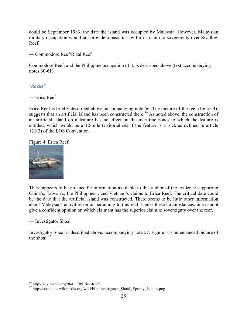
29
could be September 1983, the date the island was occupied by Malaysia. However, Malaysian military occupation would not provide a basis in law for its claim to sovereignty over Swallow Reef. — Commodore Reef/Rizal Reef Commodore Reef, and the Philippine occupation of it, is described above (text accompanying notes 60-61).
“Rocks” — Erica Reef Erica Reef is briefly described above, accompanying note 56. The picture of the reef (figure 4), suggests that an artificial island has been constructed there.96 As noted above, the construction of an artificial island on a feature has no effect on the maritime zones to which the feature is entitled, which would be a 12-mile territorial sea if the feature is a rock as defined in article 121(3) of the LOS Convention. Figure 4. Erica Reef
There appears to be no specific information available to this author of the evidence supporting China’s, Taiwan’s, the Philippines’, and Vietnam’s claims to Erica Reef. The critical date could be the date that the artificial island was constructed. There seems to be little other information about Malaysia’s activities on or pertaining to this reef. Under these circumstances, one cannot give a confident opinion on which claimant has the superior claim to sovereignty over the reef. — Investigator Shoal Investigator Shoal is described above, accompanying note 57. Figure 5 is an enhanced picture of the shoal.97
96 http://wikimapia.org/9641170/Erica-Reef. 97 http://commons.wikimedia.org/wiki/File:Investigator_Shoal,_Spratly_Islands.png.

30
Figure 5. Investigator Shoal
— Mariveles Reef Mariveles Reef is briefly described above, accompanying note 58. The following picture, figure 6, is reported to be of the reef.98 Figure 6. Mariveles Reef
98 http://commons.wikimedia.org/wiki/File:Mariveles_Reef,_Spratly_Islands.png.

31
There appears to be no specific information found by this author of the evidence supporting China’s, Taiwan’s, the Philippines’, or Vietnam’s claims to Mariveles Reef. The critical date could be 1986, the date the reef was occupied by Malaysia. If the occupation was by military force, Malaysia would not have a legitimate claim to sovereignty over the reef.
Conclusions Assuming that the Spratlys are not treated as a single unit for sovereignty purposes, there is insufficient evidence to state definitely which State (Malaysia or Vietnam) has sovereignty over the islands and rocks in the Spratlys claimed by Malaysia. It would appear that the Philippines and China have the weakest cases as to these features. As to the features not subject to appropriation that rise from Malaysia’s continental shelf, Malaysia clearly has sovereign rights over them, i.e., the low-tide elevations Dallas Reef and Ardasier Reef, and the submerged features James Shoal and North Luconia Shoals and South Luconia Shoals.

32
AppendixA:Malaysia’sdeclarationsunderArticle310,LOSConvention
1. The Malaysian Government is not bound by any domestic legislation or by any declaration issued by other States upon signature or ratification of this Convention. Malaysia reserves the right to state its positions concerning all such legislations or declarations at the appropriate time, in particular the maritime claims of any other State having signed or ratified the Convention, where such claims are inconsistent with the relevant principles of international laws and the provisions of the Convention on the Law of the Sea and which are prejudicial to the sovereign rights and jurisdiction of Malaysia in its maritime areas.
2. The Malaysian Government understands that the provisions of article 301 prohibiting ‘any
threat or use of force against the territorial integrity of any State, or in other manner inconsistent with the principles of international law embodied in the Charter of the United Nations’ apply in particular to the maritime areas under the sovereignty or jurisdiction of the coastal state.
3. The Malaysian Government also understands that the provisions of the Convention do not
authorize other States to carry out military exercises or manoeuvres, in particular those involving the use of weapon or explosives in the exclusive economic zone without the consent of the coastal state.99
4. In view of the inherent danger entailed in the passage of nuclear-powered vessels or
vessels carrying nuclear material or other material of a similar nature and in view of the provision of article 22, paragraph 2, of the Convention on the Law of the Sea concerning the right of the coastal State to confine the passage of such vessels to sea lanes designated by the State within its territorial sea, as well as that of article 23 of the Convention, which requires such vessels to carry documents and observe special precautionary measures as specified by international agreements, the Malaysian Government, with all of the above in mind, requires the aforesaid vessels to obtain prior authorization of passage before entering the territorial sea of Malaysia until such time as the international agreements referred to in article 23 are concluded and Malaysia becomes a party thereto.100 Under all circumstances, the flag State of such vessels shall assume all responsibility for any loss or damage resulting from the passage of such vessels within the territorial sea of Malaysia.
5. The Malaysian Government also wishes to reiterate the statement relating to article 233 of
the Convention in its application to the Straits of Malacca and Singapore which has been annexed to a letter dated 28th April 1982 transmitted to the President of UNCLOS III and as contained in Document A/CONF.62/L 145, UNCLOS III Off. Rec., vol. XVI, p. 250-251.
6. The ratification of the Convention by the Malaysian Government shall not in any manner affect its rights and obligations under any agreements and treaties on maritime matters entered into to which the Malaysian Government is a party.
99 The United States does not accept this claim denying the high seas freedom of navigation in the EEZ guaranteed by article 58(1) of the LOS Convention. ROACH AND SMITH, EXCESSIVE MARITIME CLAIMS 378-391 (Nijhoff 3rd ed. 2012). 100 The United States does not accept this requirement for prior authorization. ROACH AND SMITH, supra n. 96, at 254-258.
33
7. The Malaysian Government interprets article 74 and article 83 to the effect that in the absence of agreement on the delimitation of the exclusive economic zone or continental shelf or other maritime zones, for an equitable solution to be achieved, the boundary shall be the median line, namely a line every point of which is equidistant from the nearest points of the baselines from which the breadth of the territorial sea of Malaysia and of such other States is measured.
Malaysia is also of the view that in accordance with the provisions of the Convention,
namely article 56 and article 76, if the maritime area is less or to a distance of 200 nautical miles from the baselines, the boundary for continental shelf and exclusive economic zone shall be on the same line (identical).
8. The Malaysian Government declares, without prejudice to article 303 of the Convention of
the Law of the Sea, that any objects of an archeological and historical nature found within the maritime areas over which it exerts sovereignty or jurisdiction shall not be removed, without its prior notification and consent.101
Source: http://treaties.un.org/pages/ViewDetailsIII.aspx?&src=UNTSONLINE&mtdsg_no=XXI~6&chapter=21&Temp=mtdsg3&lang=en#Participants
101 The United States does not accept this claim insofar as it would apply to the EEZ and continental shelf. ROACH
AND SMITH, supra n. 96, at 549-550.
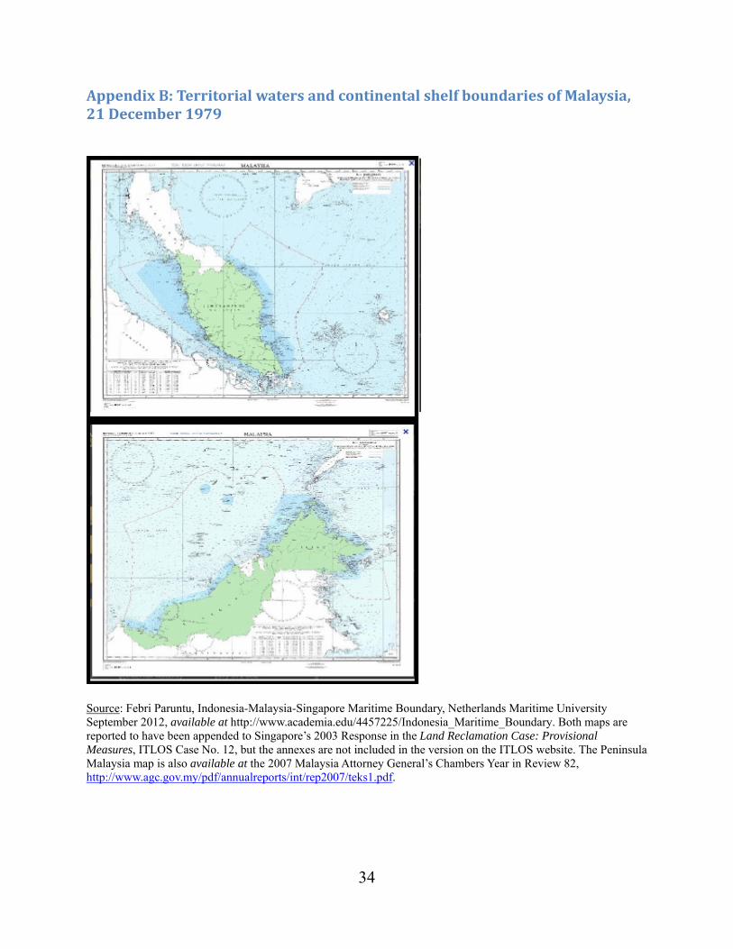
34
AppendixB:TerritorialwatersandcontinentalshelfboundariesofMalaysia,21December1979
Source: Febri Paruntu, Indonesia-Malaysia-Singapore Maritime Boundary, Netherlands Maritime University September 2012, available at http://www.academia.edu/4457225/Indonesia_Maritime_Boundary. Both maps are reported to have been appended to Singapore’s 2003 Response in the Land Reclamation Case: Provisional Measures, ITLOS Case No. 12, but the annexes are not included in the version on the ITLOS website. The Peninsula Malaysia map is also available at the 2007 Malaysia Attorney General’s Chambers Year in Review 82, http://www.agc.gov.my/pdf/annualreports/int/rep2007/teks1.pdf.
35
BruneiDarussalam’sMaritimeClaims
J. Ashley Roach105
Background Brunei has described itself in the following way:
Located in Southeast Asia on the north-western coast of the island of Borneo, bordered to the south, east and west by the Malaysian state of Sarawak. Brunei’s north-facing coastline extends for approximately 160 km [about 100 miles] along the South China Sea, including Brunei Bay.106
The eastern and western parts of Brunei are separated by Limbang province of the Malaysian state of Sarawak, until recently long claimed by Brunei,107 and Brunei Bay. The mainland of Brunei and Vietnam are about 525 miles apart at their closest points.108 Brunei gained full independence on January 1, 1984, after being a British protected state since 1888.109 Brunei signed the 1982 Law of the Sea Convention (LOS Convention) on May 12, 1984. Twelve years later, on May 11, 1996, it ratified the LOS Convention and consented to be bound by the Part XI Agreement. It has filed no declarations.110 105 Captain, JAGC, USN (ret.), Office of the Legal Adviser, U.S. Department of State (retired). This paper has been prepared in his personal capacity at the request of the Center for Naval Analyses as part of its South China Sea project. The author expresses his thanks to Kevin Baumert for his insightful comments on an earlier draft of this paper. All errors remain the responsibility of the author. 106 Brunei Darussalam’s Preliminary Submission concerning the Outer Limits of its Continental Shelf, May 12, 2009, para. 9, available at http://www.un.org/Depts/los/clcs_new/submissions_files/preliminary/brn2009preliminaryinformation.pdf (last visited Nov. 8, 2013). 107 Apparently Brunei relinquished its claim to Limbang province in 2009 in connection with the Exchange of Letters dated March 16, 2009. See infra the Press Statements accompanying notes 20 and 21 and IBRU Boundary news, “Details emerge of the 2009 Brunei-Malaysia maritime agreement,” May 13, 2010, available at https://www.dur.ac.uk/ibru/news/boundary_news/?itemno=10047&rehref=%2Fibru%2Fnews%2F&resubj=Boundary+news%20Headlines (last visited Nov. 8, 2013), and the CIA World Fact Book entry for Brunei Transnational Issues-Disputes, available at https://www.cia.gov/library/publications/the-world-factbook/geos/bx.html (last visited Nov. 9, 2013). Accord “Brunei-Malaysia border,” http://en.wikipedia.org/wiki/Brunei%E2%80%93Malaysia_border (last visited Dec. 13, 2013). 108 Miles are nautical miles measured using Google Earth. 109 For a detailed, but dated, history of Brunei, see Haller-Trost, The Brunei-Malaysia Dispute over Territorial and Maritime Claims in International Law, IBRU Maritime Briefing, vol. 1 no. 3 (1994), available at https://www.dur.ac.uk/ibru/publications/search/?series=3 (last visited Nov. 9, 2013). 110 UN DOALOS, “Table recapitulating the status of the Convention and of the related Agreements, as at 18 September 2013,” available at http://www.un.org/Depts/los/reference_files/status2010.pdf.

36
Maritimeclaims Brunei claims a 12-mile territorial sea,111 an EEZ,112 and a continental shelf.113 There is very little information available as to the implementation of Brunei’s maritime claims.114 The United Nations (UN) Division of Ocean Affairs and Law of the Sea (DOALOS) Table of Claims to Maritime Jurisdiction (as of 15 July 2011) lists Brunei as claiming a 12-mile territorial sea; a 200-mile EEZ; and a continental shelf to the outer edge of the continental margin, or to 200 nautical miles where the outer edge does not extend up to that distance.115 The DOALOS maritime legislation website only lists the Territorial Waters of Brunei Act, 1982,116 and the preliminary information of its claim to an extended continental shelf in the South China Sea.117
Baselines The Territorial Waters of Brunei Act requires that the breadth of the territorial waters “shall be measured in accordance with international law.”118 The Preliminary Submission on Brunei’s Extended Continental Shelf (ECS) merely states that its ECS “extends beyond 200 nautical miles from the baselines from which the breadth of Brunei’s territorial sea is measured.”119 It may be assumed that the normal baseline described in article 5 of the LOS Convention is being used as there appears to be no publicity of the baselines, as would be required by article 16(2) of the LOS Convention if straight baselines were being used.120
111 Article 2(1), Territorial Waters of Brunei Act, 1982, available at http://www.un.org/Depts/los/LEGISLATIONANDTREATIES/PDFFILES/BRN_1982_Act.pdf (last visited Nov. 9, 2013). 112 Declaration on the Exclusive Economic Zone, July 21, 1993, listed in Dzurek, The Spratly Islands Dispute: Who’s On First?, at 58, IBRU Maritime Briefing, vol. 2, no. 1 (1996), available at https://www.dur.ac.uk/ibru/publications/search/?series=3 (last visited Nov. 9, 2013). For a discussion of Brunei’s EEZ claim see Haller-Trost, supra n.106, at 27, 28. The earlier Brunei Fisheries Enactment, 1982, set the Brunei fisheries limits at 200 miles. UN, National Claims to Maritime Jurisdiction: Excerpts of Legislation and Table of Claims 23 (UN Sales No. E.91.V.15, 1992). For a discussion of Brunei’s fishery zone, see Haller-Trost, supra n. 106, at 43-44. 113 Royal Continental Shelf Proclamation 1954 No. S.41, June 30, 1954; Brunei’s Preliminary Submission on its extended continental shelf, paras. 10 and 11, supra n. 2. For earlier analyses of Brunei’s continental shelf claim see Dzurek, supra n. 8, at 21, and Haller-Trost, supra n. 106, at 40-42. 114 See V. PRESCOTT AND C. SCHOFIELD, THE MARITIME POLITICAL BOUNDARIES OF THE WORLD 453-455 (Nijhoff, 2nd ed. 2005). 115 Available at http://www.un.org/Depts/los/LEGISLATIONANDTREATIES/PDFFILES/table_summary_of_claims.pdf (last visited Nov. 9, 2013). 116 Available at http://www.un.org/Depts/los/LEGISLATIONANDTREATIES/PDFFILES/BRN_1982_Act.pdf (last visited Nov. 8, 2013). 117 Supra n. 103. 118 Article 2(2), Territorial Waters Act, supra n. 108. 119 Preliminary Submission, supra n. 103, para. 11. 120 See UN DOALOS, “Maritime Space: Maritime Zones and Maritime Delimitation,” available at http://www.un.org/Depts/los/LEGISLATIONANDTREATIES/depositpublicity.htm (as of Oct. 16, 2013) (last visited Nov. 19, 2013).

37
Maritimeboundaries While the DOALOS states that no information is available on Brunei’s maritime boundaries, the Preliminary Submission states:121
The maritime boundaries between Brunei and Malaysia out to 200 nautical miles have been delimited by two series of agreements.
- First, the territorial sea and continental shelf between Brunei and Malaysia were delimited as far as the 100 fathom isobath by two 1958 British Orders in Council.122 - Second, the territorial sea, the Exclusive Economic Zone and the continental shelf out to a distance of 200 nautical miles were delimited by an Exchange of Letters dated 16 March 2009.123
A press statement by the Prime Minister of Malaysia in advance of his working visit to Brunei on March 15-17, 2009, read in part:
The Honourable Dato’ Seri Abdullah Hj. Ahmad Badawi, Prime Minister of Malaysia will undertake a working visit to Bandar Seri Begawan from 15 to 16 March 2009 for the signing of the Exchange of Letters to formalise the solution of the Malaysia-Brunei Darussalam boundary issues. The idea to commence bilateral negotiation to resolve the Malaysia-Brunei Darussalam boundary issues was first raised in 1994. Negotiations were also taking place in 1997. However, both sides were unable to arrive at a mutually accepted solution. After that, both countries resumed negotiations from May 2003 until August 2008. Through this series of negotiation, both countries finally agreed to a package solution that includes maritime boundaries between Malaysia and Brunei Darussalam, collaboration in the exploration and exploitation of hydrocarbon resources, and the demarcation of land boundaries between the two countries. The solution of the abovementioned issues ensures certainty with regard to sovereign rights and jurisdiction on the continental shelf and the Exclusive Economic Zone of both countries. At the same time, the overlapping maritime claims between the two countries are also resolved. Furthermore, the solution enabled both countries to embark on new developments and impose enforcement of rules and regulations in their respective maritime zones without any conflicts. . . . 124
121 Preliminary Submission, supra n. 103, para. 10. 122 The North Borneo (Definition of Boundaries) Order in Council, 1958, Statutory Instruments 1958 No. 1517; and the Sarawak (Definition of Boundaries) Order in Council, 1958, Statutory Instruments 1958 No. 1518 [footnote in the original]. While these statutory instruments are not listed on the UK National Archives website for 1958, http://www.legislation.gov.uk/uksi (last visited Nov. 8, 2013), they are reproduced in I INTERNATIONAL MARITIME
BOUNDARIES 915, 924-928 (Nijhoff 1993), available at http://nijhoffonline.nl/pages/IMB (subscription) (last visited Nov. 9, 2013). 123 The texts of these letters appear not to be publicly available. See Smith, Brunei and Malaysia resolve outstanding maritime boundary issues, ASIL LOS Reports, vol. 1 (2010), available at http://www.asil.org (under reconstruction). 124 Minister of Foreign Affairs, Malaysia, Press Statement, March 13, 2009, available through links at http://www.kln.gov.my/web/guest/arkib (emphasis added) (last visited Nov. 8, 2013).

38
At the conclusion of their meeting the two leaders issued the following joint statement:
Joint Press Statement by Leaders on the Occasion of the Working Visit of Yab Dato’ Seri Abdullah Haji Ahmad Badawi, Prime Minister of Malaysia to Brunei Darussalam on 15-16 March 2009
* * * *
Both leaders held a four-eyed meeting at Istana Nurul Iman on 16 March 2009. The two leaders also signed an Exchange of Letters to mark the successful conclusion of negotiations which had been ongoing for many years on outstanding bilateral issues between the two countries, having regard to historical, legal and other relevant criteria acceptable to both sides. Both Leaders noted the agreement of their respective Governments on the key elements contained in the Exchange of Letters, which included the final delimitation of maritime boundaries between Brunei Darussalam and Malaysia, the establishment of Commercial Arrangement Area (CAA) in oil and gas, the modalities for the final demarcation of the land boundary between Brunei Darussalam and Malaysia and unsuspendable rights of maritime access for nationals and residents of Malaysia across Brunei’s maritime zones en route to and from their destination in Sarawak, Malaysia provided that Brunei’s laws and regulations are observed. The solution of the maritime delimitation issue ensures certainty with regard to the delimitation of the territorial seas, the continental shelf and the Exclusive Economic Zone of both countries. The two countries would be able to enforce their rules and regulations and embark on new developments in their respective maritime zones. The demarcation of the land boundaries between the two countries will be resolved on the basis of five (5) existing historical agreements between the Government of Brunei and the Government of Sarawak, and, as appropriate, the watershed principle. Hereafter, all issues pertaining to land boundaries of the two states shall be accordingly resolved.
* * * *
Both Leaders believe that the above-mentioned signing and exchange of letters will pave the way for the development of strategic partnership and closer collaboration between the two countries in all fields, especially trade and investment, energy and hydrocarbon resources, tourism, education, agriculture, infrastructure, banking, halal industry and people-to-people contacts with special focus on the Malaysian States of Sabah and Sarawak. . . . Bandar Seri Begawan 16 March 2009125
Neither Brunei nor Malaysia has given the due publicity to these maritime boundaries required by articles 75(2) and 84(2).126
125 Available at http://bn.chineseembassy.org/eng/wlxw/t542877.htm (emphasis added) (last visited Nov. 19, 2013). 126 See UN DOALOS, “Maritime Space: Maritime Zones and Maritime Delimitation,” supra n. 117. See also Beckman, The UN Convention on the Law of the Sea and the Maritime Disputes in the South China Sea, 107 AJIL 142, at 149 n. 48 and accompanying text (2013).

39
The May 9, 2009, Joint Submission by Malaysia and Vietnam on the extended continental shelf in the southern part of the South China Sea shows a continuous line for the Malaysian 200-mile limit and much shorter Brunei-Malaysia international boundaries to the edge of the shallow portion of the shelf.127 This Joint Submission prompted a series of notes from China, the Philippines, Vietnam, Malaysia, and Indonesia.128 Of significance to this paper is China’s note of May 9, 2009, as it included the first official publication of the nine-dash line, which passes close to the East Malaysian and Brunei coasts.129 Brunei has not publicly protested the nine-dash line or the depiction of the Malaysian 200-mile limit, which appears to deny Brunei a 200-mile continental shelf and an extended continental shelf.130 The Brunei Preliminary Information has not produced any official published reactions.
Louisa Reef (6°20′7″N 113°16′47″E) There appears to be only one offshore feature in the Brunei EEZ, Louisa Reef, which is currently claimed by Brunei and China.131 Apparently the Malaysia claim to Louisa Reef has been rescinded.132 There is no agreement in the literature on whether Louisa Reef is an island, a low-tide elevation, or submerged at all times. Louisa Reef lies about 120 miles northwest of the Brunei coastline and 408 miles from Vietnam. One source describes it as a quadrilateral reef with sides about 1.2 miles long with a number of rocks on its surface. Two clusters in the northeast and southwest reportedly do not cover and stand one meter above water level.133 It is not clear from the sources in note 29 whether the feature “above water level” is at high or low tide.
127 Joint Submission to the Commission on the Limits of the Continental Shelf Executive Summary, Figures 1 and 2, May 9, 2009, available at http://www.un.org/Depts/los/clcs_new/submissions_files/submission_mysvnm_33_2009.htm (last visited Nov. 9, 2013). It should be noted that the map of the South China Sea published in conjunction with the Agora on the South China Sea at 107 AJIL 96 (2013) shows the two agreed Malaysia-Brunei boundaries extending past the joint CLCS submission to what appears to be the median line with Vietnam. 128 The 10 notes are available at http://www.un.org/Depts/los/clcs_new/submissions_files/submission_mysvnm_33_2009.htm (last visited Nov. 19, 2013). 129 Chinese Mission to the UN note CML/18/2009, May 7, 2009, available at http://www.un.org/Depts/los/clcs_new/submissions_files/mysvnm33_09/chn_2009re_mys_vnm_e.pdf (last visited Nov. 19, 2013). 130 The Malaysian claim is criticized in Poling, The South China Sea in Focus: Clarifying the Limits of Maritime Dispute 8-9 (Washington, CSIS 2013), available at http://csis.org/files/publication/130717_Poling_SouthChinaSea_Web.pdf (last visited Nov. 9, 2013). 131 See the discussion of Louisa Reef in Haller-Trost, supra n. 106, at 45, 48-49. 132 Inferred from the texts of the Press Statements quoted above accompanying notes 20 and 21. 133 Hancok and Prescott, A Geographical Description of the Spratly Islands and an Account of Hydrographic Surveys Amongst Those Islands, IBRU Maritime Briefing, vol. 1 no. 6, at 20 (1995), available at https://www.dur.ac.uk/ibru/publications/search/?series=3; and Digital Gazetteer of the Spratly Islands (undated), available at http://middlebury.edu/~scs/macand/gazetter.htm (both last visited Nov. 9, 2013). Reportedly Brunei

40
Another source described Louisa Reef as follows:
Louisa Reef, known as Nantong Jiao (Chinese: 南通礁) in China and Terumbu Semarang Barat Kecil in Malaysia, operates a lighthouse here. Only exposed at times of low water, the Louisa Reef is 128 km south-southwest of Swallow Reef. It rises as deeply undercut walls and steep slopes from very deep water with wonderful stony and soft corals. Safe anchorage is difficult to find, depending on the wind and currents there are sandy areas at the northwest and southwest ends but one must be on constant watch for changes in the wind, the nearest real shelter is the lagoon at Swallow Reef. Louisa Reef is oval in shape, approximately 1.5 km east to west and 0.5 km north to south. The navigation beacon at its southwest point and the highest visible rock is at the southeast end. The reef itself abounds with pristine coral growth, with a prolific amount of staghorn coral on the north and west walls. The sandy patches south and west of the beacon give excellent night diving.134
If the feature is above water at high tide,135 Louisa Reef is an “island” as defined in article 121(1) of the LOS Convention. However, it should be characterized as a “rock” as that term is defined in article 121(3) given that it is very small, is uninhabited, and does not appear to have an economic life of its own. If characterized as a rock under article 121(3), it would be entitled only to a 12-mile territorial sea. On the other hand, if it is below water at high tide but above water at low tide,136 it is a low-tide elevation,137 and, as it lies outside the territorial sea of Brunei, it then has no territorial sea of its own138 and is not subject to appropriation.139 Another source states that Louisa Reef is completely submerged.140 If so, it is part of the Brunei continental shelf with no territorial sea of its own and is not subject to appropriation.
declared the reef to be a wildlife sanctuary in 1948. Coastal Reef MPAs of East Asia and Micronesia, available at http://mpa.reefbase.org/database.aspx (last visited Nov. 9, 2013). 134 http://www.ask.com/wiki/Louisa_Reef?o=2801&qsrc=999&ad=doubleDown&an=apn&ap=ask.com (last visited Dec. 12, 2013). 135 Dzurek, supra n. 8, at 45; Haller-Trost, supra n. 5, at 45. The 2010 USG map of the Spratly Islands shows Louisa Reef with a 12-mile territorial sea (803425AI (GO2257) 1-10), thereby implying that it is an island (as defined in article 121(1)), being above water at high tide. 136 Storey, Testing Brunei’s resolve over China, The Straits Times, Dec. 10, 2012, available at http://www.iseas.edu.sg/documents/publication/is10dec12.pdf (“Louisa Reef is a low-tide elevation”) (last viewed Nov. 9, 2013). The report on the Orders in Council, INTERNATIONAL MARITIME BOUNDARIES 915 states at 920 “[i]t was noted by Brunei in 1983 that there did not appear to be any feature which stood above high tide in the zone it was claiming. This indicates that Brunei denies the existence of rocks which stand above high tide on Louisa Reef.” The Wikipedia article, quoted above accompanying note 30, states that Louisa Rock is exposed only at low tide. 137 LOS Convention, art. 13(1). 138 LOS Convention, art. 13(2). 139 Nicaragua v. Colombia, 2012 ICJ Judgment 19 para. 26, available at http://www.icj-cij.org/docket/files/124/17164.pdf (last visited Nov. 11, 2013). 140 C. Joyner, The Spratly Island Dispute in the South China Sea: Problems, Policies, and Prospects for Diplomatic Accommodation, Stimson Center Report, Investigating Confidence-Building Measures in the Asia-Pacific Region
41
The map of the territorial waters and continental shelf boundaries of Malaysia, 21 December 1979, does not show a territorial sea around Louisa Reef as it does with only two other features (Swallow Reef and Amboyna Cay). This suggests that the feature is a low-tide elevation. If Louisa Reef is characterized as an island under article 121(1), it will be difficult to argue that it is entitled to an EEZ or continental shelf.
Sovereignty Land generates maritime zones, not vice versa.141 Accordingly, sovereignty over the territorial sea and sovereign rights over the EEZ and continental shelf follow the sovereignty of the adjacent mainland or island.142 Further, only the State that has sovereignty over those maritime features that generate maritime zones, i.e., islands as defined in article 121, is entitled to those maritime zones. The international legal rules for deciding sovereignty disputes are well established.143 The rules for acquisition of territory were concisely summarized by the tribunal in the first (1998) Eritrea/Yemen Arbitration Award:
The modern international law of the acquisition (or attribution) of territory generally requires that there be: an intentional display of power and authority over the territory, by the exercise of jurisdiction and state functions, on a continuous and peaceful basis. The latter two criteria are tempered to suit the nature of the territory and size of its population, if any.144
53, 64 (1998), asserts Louisa Reef is submerged at all times, available at http://www.stimson.org/images/uploads/research-pdfs/cbmapspratly.pdf (last visited Dec. 14, 2013). 141 North Sea Continental Shelf Cases (Ger. v. Den.; Ger. v. Neth.), 1969 ICJ REP. 3, 22 para. 19, and 29 para. 39, available at http://www.icj-cij.org/docket/files/52/5561.pdf. 142 LOS Convention, arts. 2(1), 55, 76(1), 77(1) and 77(3). 143 See James Crawford, The Acquisition and Transfer of Territorial Sovereignty, BROWNLIE’S PRINCIPLES OF PUBLIC
INTERNATIONAL LAW, chapter 9 (Oxford, 8th ed. 2012). 144 Award of the Arbitral Tribunal in the first stage of the proceedings between Eritrea and Yemen (Territorial Sovereignty and Scope of the Dispute), (1998) 22 RIAA 268, para. 239), available at http://untreaty.un.org/cod/riaa/cases/vol_XXII/209-332.pdf. Judge Dugard, in his dissenting opinion in the Pedra Branca/Pulau Batu Puteh case, stated:
This formulation requires serious attention for two reasons. First, because it gives effect to the jurisprudence of contemporary international law from the time of Max Huber’s seminal decision in the Island of Palmas Case (Netherlands/United States of America) (Award of 4 April 1928, RIAA, Vol. II (1949), pp. 839, 868). Secondly, because it was expounded by a Tribunal comprising two former Presidents of the International Court of Justice (Professor Sir Robert Y. Jennings and Judge Stephen M. Schwebel), the President of the Court (Judge Rosalyn Higgins) and two highly experienced and well regarded international law practitioners (Dr. Ahmed Sadek El-Kosheri and Mr. Keith Highet). In my view, this is a formulation of the law on the acquisition of territory that is to govern all acquisitions of territorial title based on the effective control of territory over a long period of time, including prescription, estoppel, abandonment of title by the previous sovereign, acquiescence and tacit agreement evidenced by conduct.
Sovereignty over Pedra Branca/Pulau Batu Puteh, Middle Rocks and South Ledge (Malaysia/Singapore), 2008 ICJ REP. 133, 150-151 para. 42.
42
In the 1931 award in the dispute between Mexico and France over the sovereignty of Clipperton Island, located in the Pacific Ocean 1,280 km (~ 690 miles) southwest of Acapulco, Mexico, the King of Italy as sole arbitrator had previously stated the rules this way:
It is beyond doubt that by immemorial usage having the force of law, besides the animus occupandi, the actual, and not the nominal, taking of possession is a necessary condition of occupation. This taking of possession consists in the act, or series of acts, by which the occupying state reduces to its possession the territory in question and takes steps to exercise exclusive authority there. Strictly speaking, and in ordinary cases, that only takes place when the state establishes in the territory itself an organization capable of making its laws respected. But this step is, properly speaking, but a means of procedure to the taking of possession, and, therefore, is not identical with the latter. There may also be cases where it is unnecessary to have recourse to this method. Thus, if a territory, by virtue of the fact that it was completely uninhabited, is, from the first moment when the occupying state makes its appearance there, at the absolute and undisputed disposition of that state, from that moment the taking of possession must be considered as accomplished, and the occupation is thereby completed.
**** There is no reason to suppose that France has subsequently lost her right by derelictio, since she never had the animus of abandoning the island, and the fact that she has not exercised her authority there in a positive manner does not imply the forfeiture of an acquisition already definitively perfected.145
In the separate opinion of Judge Carneiro in the case of the Minquiers and Ecrehos islands (France/United Kingdom), ICJ 1953, the judge laid out the rules for determining sovereignty in greater detail:
2. Criterion for the decision. -- In this Opinion I have confined myself to the following rules which were laid down by the Permanent Court of International Justice in the case concerning the Legal Status of Eastern Greenland:146
(a) the elements necessary to establish a valid title to sovereignty are “the intention and wil1 to exercise such sovereignty and the manifestation of State activity” (pp. 46 and 63);
(b) in many cases international jurisprudence “has been satisfied with very little in the way of the actual exercise of sovereign rights, provided that the other State could not make out a superior claim. This is particularly true in the case of claims to sovereignty over areas in thinly populated or unsettled countries”. (p. 46);
(c) it is the criterion of the Court in each individual case which decides whether sovereign rights have been displayed and exercised “to an extent sufficient to constitute a valid title to sovereignty” (pp. 63-64).147
In this case, Judge Carneiro then applied these rules to the interpretation of treaties and other ancient documents by considering the following factors: the historical moment that the documents were concluded and their specificity regarding the islands in question; the attitudes of the parties regarding the features in question; geographical data; the natural unity of the islands; proximity of the mainland and relevant historical facts; acts of occupation; visits of fishermen;
145 26 AJIL 390, at 393-394 (1932), available at http://www.jstor.org/stable/pdfplus/2189369.pdf. 146 Available at http://www.icj-cij.org/pcij/serie_AB/AB_48/01_Groenland_ordonnance_1932080.pdf. 147 The Miniquiers and Ecrhos case, individual opinion of Judge Carniero, 1953 ICJ REP. 85, available at http://www.icj-cij.org/docket/files/17/2029.pdf.

43
maps (which in this case were not taken into consideration); and diplomatic protests of the parties. In the case of Nicaragua v. Honduras, the ICJ recalled the Indonesia/Malaysia case where the Court indicated that
in the case of very small islands which are uninhabited or not permanently inhabited — like Ligitan and Sipadan, which have been of little economic importance (at least until recently) — effectivités will indeed generally be scarce” (Sovereignty over Pulau Ligitan and Pulau Sipadan (Indonesia/Malaysia), Judgment, I.C.J. Reports 2002, p. 682, para. 134).148
More recently, in the case of Nicaragua v. Colombia, the ICJ noted that
a significant element to be taken into account is the extent to which any acts à titre de souverain in relation to disputed islands have been carried out by another State with a competing claim to sovereignty. As the Permanent Court of International Justice stated in its Judgment in the Legal status of Eastern Greenland case [quoted above]:
“It is impossible to read the records of the decisions in cases as to territorial sovereignty without observing that in many cases the tribunal has been satisfied with very little in the way of the actual exercise of sovereign rights, provided that the other State could not make out a superior claim. This is particularly true in the case of claims to sovereignty over areas in thinly populated or unsettled countries.” (Legal status of Eastern Greenland, Judgment, 1933, P.C.I.J. Series A/B, No. 53, p. 46.)149
Analysisandconclusions There seems to be little evidence publicly available as to what acts à titre de souverain China has taken vis á vis Louisa Reef. Haller-Trost reported in 1994 that China erected a stone marker on the reef in October 1987.150 China’s claim to Louisa Reef is not mentioned in the 2013 American Journal of International Law Agora on the South China Sea.151 Brunei, on the other hand, maintains its claim to Louisa Reef.152 Accordingly, to the extent that Louisa Reef is an island and subject to appropriation, Brunei would appear to have the better claim to sovereignty over Louisa Reef. If, on the other hand, Louisa Reef is either a low-tide elevation or a submerged feature, it is not subject to appropriation and is simply part of Brunei’s continental shelf.
148 Territorial and Maritime Dispute between Nicaragua and Honduras in the Caribbean Sea (Nicaragua v. Honduras), Judgment, 2007 ICJ REP. 659, 712 para. 174, available at http://www.icj-cij.org/docket/files/120/14075.pdf. 149 Territorial and Maritime Dispute (Nicaragua v. Colombia), 2012 ICJ REP. 1, 32 para. 80, available at http://www.icj-cij.org/docket/files/124/17164.pdf. 150 Haller-Trost, supra n. 106, at 48. The marker was removed by Malaysia the following year. Ibid. 151 107 AJIL 95-163 (2013). 152 Haller-Trost, supra n. 106, at 48-49.

44
In any case, China likely has no plausible claim to the waters of Brunei’s EEZ included within the nine-dash line.

The CNA Corporation This report was authored by CNA Corporation’s Strategic Studies (CSS) division.
CNA Corp. Strategic Studies division is CNA's focal point for regional expertise and analyses, political-military studies, and U.S. strategy and force assessments. Its research approach anticipates a broad scope of plausible outcomes assessing today’s issues, analyzing trends, and identifying "the issue after next,” using the unique operational and policy expertise of its analysts.
IOP-2014-U-008434-Final
www.cna.org ● 703-824-2000
3003 Washington Boulevard, Arlington, VA 22201