M a p o f S t a t u t o r y N a t u r a l H a z a r d Z o ...€¦ · S t a t u t o r y N a t u r a...
49
Map of Statutory Natural Hazard Zones This map is provided for convenience only to show the approximate location of the Property and is not based on a field survey. JCP-LGS Residential Property Disclosure Reports Map of Statutory Natural Hazards For SANTA CLARA County Property Address: 38 N ALMADEN BLVD #1119 APN: 259-59-163 SAN JOSE, SANTA CLARA COUNTY, CA95110 Report Date: 01/17/2017 ("Property") Report Number: 2033807 ©2017 - JCP-LGS Disclosure Reports - 200 Commerce, Suite 100, Irvine, CA 92602 Phone: (800) 748-5233 Fax: (800) 329-9527 Page 1 of 49
Transcript of M a p o f S t a t u t o r y N a t u r a l H a z a r d Z o ...€¦ · S t a t u t o r y N a t u r a...
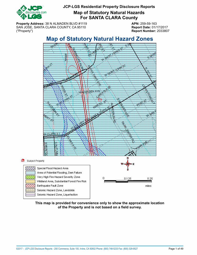
Map of Statutory Natural Hazard Zones
This map is provided for convenience only to show the approximate locationof the Property and is not based on a field survey.
JCP-LGS Residential Property Disclosure ReportsMap of Statutory Natural Hazards
For SANTA CLARA CountyProperty Address: 38 N ALMADEN BLVD #1119 APN: 259-59-163SAN JOSE, SANTA CLARA COUNTY, CA 95110 Report Date: 01/17/2017("Property") Report Number: 2033807
©2017 - JCP-LGS Disclosure Reports - 200 Commerce, Suite 100, Irvine, CA 92602 Phone: (800) 748-5233 Fax: (800) 329-9527 Page 1 of 49

Map of Environmental Hazard Sites
NOTE: The foregoing map may show more sites than are reported in the listing below. The map shows all sites found within thesquare coverage area. The listing below reports only those sites found within the standard radius search distance for the databaselisted, which covers a smaller area. Sites outside of that standard radius search distance are not listed below. The standard radiussearch distances for point sources are defined by the U.S. Environmental Protection Agency's "All Appropriate Inquiries" (AAI)guidelines. The AAI standard search distance differs between database categories, depending upon degree of potential hazard.Pipeline search distance (2,000 feet, red dashed circle on map) complies with U.S. bill H.R. 22 (Speier). See section called"Explanation of Databases Used" for the actual standard search distance used for each database category.
(NPL) Federal National Priorities List or "Superfund" Sites (SWIS) Solid Waste Landfill Facilities
(RCRA COR) Corrective Action Sites (SLIC) Spills, Leaks, Investig. & Cleanup
(LUST) Leaking Underground Storage Tanks California EnviroStor State Response Sites
Oil or Gas Well Gas Transmission Pipelines (Approximate)
Hazardous Liquid Pipelines (Approximate)
©2017 - JCP-LGS Disclosure Reports - 200 Commerce, Suite 100, Irvine, CA 92602 Phone: (800) 748-5233 Fax: (800) 329-9527 Page 2 of 49
JCP-LGS Residential Property Disclosure ReportsMap of Environmental Hazard Sites
For SANTA CLARA CountyProperty Address: 38 N ALMADEN BLVD #1119 APN: 259-59-163SAN JOSE, SANTA CLARA COUNTY, CA 95110 Report Date: 01/17/2017("Property") Report Number: 2033807

Statutory Natural Hazard Disclosure ("NHD") Statementand Acknowledgment of Receipt
The transferor and his or her agent(s) or a third-party consultant disclose the following information with the knowledge that even though this is not a warranty,prospective transferees may rely on this information in deciding whether and on what terms to purchase the Property. Transferor hereby authorizes any agent(s)representing any principal(s) in this action to provide a copy of this statement to any person or entity in connection with any actual or anticipated sale of the Property.
The following are representations made by the transferor and his or her agent(s) based on their knowledge and maps drawn by the State. This information is adisclosure and is not intended to be part of any contract between the transferee and the transferor. THIS REAL PROPERTY LIES WITHIN THE FOLLOWINGHAZARDOUS AREA(S):
A SPECIAL FLOOD HAZARD AREA (Any type Zone "A" or "V") designated by the Federal Emergency Management AgencyYes No X Do not know and information not available from local jurisdiction AN AREA OF POTENTIAL FLOODING shown on a dam failure inundation map pursuant to Section 8589.5 of the Government Code.Yes X No Do not know and information not available from local jurisdiction A VERY HIGH FIRE HAZARD SEVERITY ZONE pursuant to Section 51178 or 51179 of the Government Code. The owner of this Property is subject to themaintenance requirements of Section 51182 of the Government Code.Yes No X A WILDLAND AREA THAT MAY CONTAIN SUBSTANTIAL FOREST FIRE RISK AND HAZARDS pursuant to Section 4125 of the Public Resources Code. Theowner of this Property is subject to the maintenance requirements of Section 4291 of the Public Resources Code. Additionally, it is not the state's responsibility toprovide fire protection services to any building or structure located within the wildlands unless the Department of Forestry and Fire Protection has entered into acooperative agreement with a local agency for those purposes pursuant to Section 4142 of the Public Resources Code.Yes No X AN EARTHQUAKE FAULT ZONE pursuant to Section 2622 of the Public Resources Code.Yes No X A SEISMIC HAZARD ZONE pursuant to Section 2696 of the Public Resources Code.Yes (Landslide Zone) Yes (Liquefaction Zone) X
No Map not yet released by state THESE HAZARDS MAY LIMIT YOUR ABILITY TO DEVELOP THE REAL PROPERTY, TO OBTAIN INSURANCE, OR TO RECEIVE ASSISTANCE AFTER ADISASTER. THE MAPS ON WHICH THESE DISCLOSURES ARE BASED ESTIMATE WHERE NATURAL HAZARDS EXIST. THEY ARE NOT DEFINITIVEINDICATORS OF WHETHER OR NOT A PROPERTY WILL BE AFFECTED BY A NATURAL DISASTER. TRANSFEREE(S) AND TRANSFEROR(S) MAY WISH TOOBTAIN PROFESSIONAL ADVICE REGARDING THOSE HAZARDS AND OTHER HAZARDS THAT MAY AFFECT THE PROPERTY.
Signature of Transferor(s) Date Signature of Transferor(s) Date
Signature of Agent Date Signature of Agent Date
X Transferor(s) and their agent(s) represent that the information herein is true and correct to the best of their knowledge as of the date signed by the transferor(s)and agent(s).
X Transferor(s) and their agent(s) acknowledge that they have exercised good faith in the selection of a third-party report provider as required in Civil Code Section1103.7, and that the representations made in this Natural Hazard Disclosure Statement are based upon information provided by the independent third-partydisclosure provider as a substituted disclosure pursuant to Civil Code Section 1103.4. Neither transferor(s) nor their agent(s) (1) has independently verified theinformation contained in this statement and Report or (2) is personally aware of any errors or inaccuracies in the information contained on the statement. Thisstatement was prepared by the provider below:
Third-Party Disclosure Provider(s) FIRST AMERICAN PROFESSIONAL REAL ESTATE SERVICES, INC. OPERATING THROUGH ITS JCP-LGS DIVISION.Date 17 January 2017
Transferee represents that he or she has read and understands this document. Pursuant to Civil Code Section 1103.8, the representations in this Natural HazardDisclosure Statement do not constitute all of the transferor's or agent's disclosure obligations in this transaction.
Signature of Transferee(s) Date Signature of Transferee(s) Date TRANSFEREE(S) REPRESENTS ABOVE HE/SHE HAS RECEIVED, READ AND UNDERSTANDS THE COMPLETE JCP-LGS DISCLOSURE REPORT DELIVERED WITH THIS SUMMARY:
A. Additional Property-specific Statutory Disclosures: Former Military Ordnance Site, Commercial/Industrial Use Zone, Airport Influence Area, Airport Noise, SanFrancisco Bay Conservation and Development District Jurisdiction (in S.F. Bay counties only), California Energy Commission Duct Sealing Requirement, Notice ofStatewide Right to Farm, Notice of Mining Operations, Sex Offender Database (Megan's Law), Gas and Hazardous Liquid Transmission Pipeline Database.
B. Additional County and City Regulatory Determinations as applicable: Airports, Avalanche, Blow Sand, Coastal Zone, Dam/Levee Failure Inundation, Debris Flow,Erosion, Flood, Fault Zone, Fire, Groundwater, Landslide, Liquefaction, Methane Gas, Mines, Naturally Occurring Asbestos, Redevelopment Area, Right to Farm,Runoff Area, Seiche, Seismic Shaking, Seismic Ground Failure, Slope Stability, Soil Stability, Subsidence, TRPA, Tsunami.
C. General advisories: Methamphetamine Contamination, Mold, Radon, Endangered Species Act, Abandoned Mines, Oil & Gas Wells, Tsunami Maps (coastal only),Wood-burning fireplaces.
D. Additional Reports - Enclosed if ordered: (1) PROPERTY TAX REPORT (includes state-required Notices of Mello-Roos and 1915 Bond Act Assessments, andNotice of Supplemental Property Tax Bill, (2) ENVIRONMENTAL SCREENING REPORT (discloses Transmission Pipelines, Contaminated Sites, and Oil & GasWells). Enclosed if applicable: Local Addenda.
E. Government Guides in Combined Booklet with Report. Refer to Booklet: (1) ENVIRONMENTAL HAZARDS: "A Guide for Homeowners, Buyers, Landlords andTenants"; (2) EARTHQUAKE SAFETY: "The Homeowners Guide To Earthquake Safety" and included "RESIDENTIAL EARTHQUAKE HAZARDS REPORT FORM";(3) LEAD-BASED PAINT: "Protect Your Family From Lead In Your Home"; (4) BRIEF GUIDE TO MOLD, MOISTURE AND YOUR HOME; (5) WHAT IS YOUR HOMEENERGY RATING? Government Guides are also available on the Company's "Electronic Bookshelf" at http://www.disclosures.com/.
©2017 - JCP-LGS Disclosure Reports - 200 Commerce, Suite 100, Irvine, CA 92602 Phone: (800) 748-5233 Fax: (800) 329-9527 Page 3 of 49
JCP-LGS Residential Property Disclosure ReportsNatural Hazard Disclosure (NHD) Report
For SANTA CLARA CountyProperty Address: 38 N ALMADEN BLVD #1119 APN: 259-59-163SAN JOSE, SANTA CLARA COUNTY, CA 95110 Report Date: 01/17/2017("Property") Report Number: 2033807
Table of ContentsMap of Statutory Natural Hazards.................................................................................. 1Environmental Hazard Map............................................................................................ 2Statutory NHD Statement and Acknowledgment of Receipt...........................................3Table of Contents............................................................................................................4Summary of Disclosure Determinations......................................................................... 5-6NHD Report.................................................................................................................... 7-28Tax Report...................................................................................................................... 29-36Environmental Report..................................................................................................... 37-45Terms and Conditions..................................................................................................... 46-47Addenda......................................................................................................................... 48-49
©2017 - JCP-LGS Disclosure Reports - 200 Commerce, Suite 100, Irvine, CA 92602 Phone: (800) 748-5233 Fax: (800) 329-9527 Page 4 of 49
JCP-LGS Residential Property Disclosure ReportsContents
For SANTA CLARA CountyProperty Address: 38 N ALMADEN BLVD #1119 APN: 259-59-163SAN JOSE, SANTA CLARA COUNTY, CA 95110 Report Date: 01/17/2017("Property") Report Number: 2033807
PROPERTY DISCLOSURE SUMMARY - READ FULL REPORT
StatutoryNHD Determinations IN
NOTIN
MapN/A* Property is:
NHDReportpage:
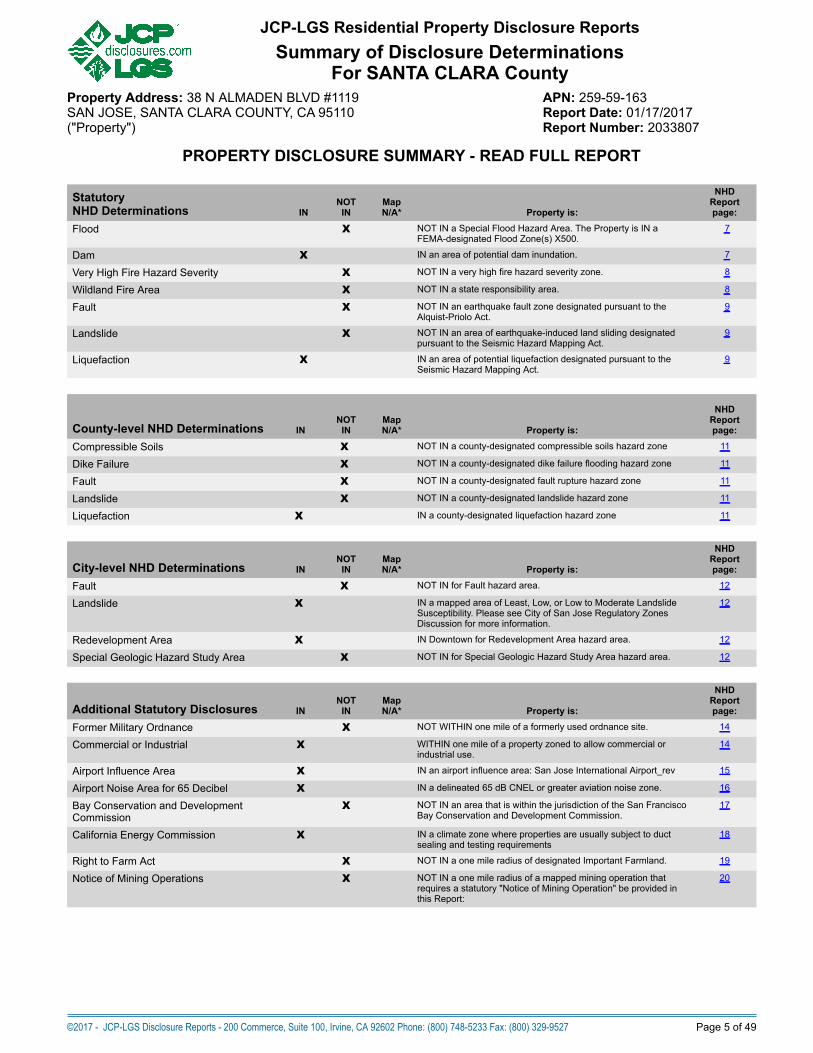
Flood X NOT IN a Special Flood Hazard Area. The Property is IN aFEMA-designated Flood Zone(s) X500.
7
Dam X IN an area of potential dam inundation. 7
Very High Fire Hazard Severity X NOT IN a very high fire hazard severity zone. 8
Wildland Fire Area X NOT IN a state responsibility area. 8
Fault X NOT IN an earthquake fault zone designated pursuant to theAlquist-Priolo Act.
9
Landslide X NOT IN an area of earthquake-induced land sliding designatedpursuant to the Seismic Hazard Mapping Act.
9
Liquefaction X IN an area of potential liquefaction designated pursuant to theSeismic Hazard Mapping Act.
9
County-level NHD Determinations INNOT
INMapN/A* Property is:
NHDReportpage:
Compressible Soils X NOT IN a county-designated compressible soils hazard zone 11
Dike Failure X NOT IN a county-designated dike failure flooding hazard zone 11
Fault X NOT IN a county-designated fault rupture hazard zone 11
Landslide X NOT IN a county-designated landslide hazard zone 11
Liquefaction X IN a county-designated liquefaction hazard zone 11
City-level NHD Determinations INNOT
INMapN/A* Property is:
NHDReportpage:
Fault X NOT IN for Fault hazard area. 12
Landslide X IN a mapped area of Least, Low, or Low to Moderate LandslideSusceptibility. Please see City of San Jose Regulatory ZonesDiscussion for more information.
12
Redevelopment Area X IN Downtown for Redevelopment Area hazard area. 12
Special Geologic Hazard Study Area X NOT IN for Special Geologic Hazard Study Area hazard area. 12
Additional Statutory Disclosures INNOT
INMapN/A* Property is:
NHDReportpage:
Former Military Ordnance X NOT WITHIN one mile of a formerly used ordnance site. 14
Commercial or Industrial X WITHIN one mile of a property zoned to allow commercial orindustrial use.
14
Airport Influence Area X IN an airport influence area: San Jose International Airport_rev 15
Airport Noise Area for 65 Decibel X IN a delineated 65 dB CNEL or greater aviation noise zone. 16
Bay Conservation and DevelopmentCommission
X NOT IN an area that is within the jurisdiction of the San FranciscoBay Conservation and Development Commission.
17
California Energy Commission X IN a climate zone where properties are usually subject to ductsealing and testing requirements
18
Right to Farm Act X NOT IN a one mile radius of designated Important Farmland. 19
Notice of Mining Operations X NOT IN a one mile radius of a mapped mining operation thatrequires a statutory "Notice of Mining Operation" be provided inthis Report:
20
JCP-LGS Residential Property Disclosure ReportsSummary of Disclosure Determinations
For SANTA CLARA CountyProperty Address: 38 N ALMADEN BLVD #1119 APN: 259-59-163SAN JOSE, SANTA CLARA COUNTY, CA 95110 Report Date: 01/17/2017("Property") Report Number: 2033807
©2017 - JCP-LGS Disclosure Reports - 200 Commerce, Suite 100, Irvine, CA 92602 Phone: (800) 748-5233 Fax: (800) 329-9527 Page 5 of 49

General Advisories Description
NHDReportpage:
Registered Sex Offender Data Base(Megan's Law) Notice
Provides an advisory required pursuant to Section 290.46 of the Penal Code. Informationabout specified registered sex offenders is made available to the public.
21
Gas and Hazardous Liquid TransmissionPipeline Database Notice
Provides a notice required pursuant to Section 2079.10.5(a) of the Civil Code. Informationabout transmission pipeline location maps is made available to the public.
22
Methamphetamine Contamination Provides an advisory that a disclosure may be required pursuant to the "MethamphetamineContaminated Property Cleanup Act of 2005".
23
Mold Provides an advisory that all prospective purchasers of residential and commercial propertyshould thoroughly inspect the subject property for mold and sources for additional informationon the origins of and the damage caused by mold.
24
Radon Provides an advisory on the risk associated with Radon gas concentrations. 25
Endangered Species Provides an advisory on resources to educate the public on locales of endangered orthreatened species.
25
Abandoned Mines Provides an advisory on resources to educate the public on the hazards posed by, and someof the general locales of, abandoned mines.
26
Oil and Gas Wells Provides an advisory on the potential existence of oil and gas wells and sources for additionalgeneral and/or specific information.
26
Tsunami Map Advisory Provides an advisory about maximum tsunami inundation maps issued for jurisdictionalemergency planning.
27
Residential Fireplace Disclosure Provides disclosure of restrictions on the use of wood-burning fireplaces imposed by the BayArea Air Quality Management District.
28
Local Addendums Description
NHDReportpage:
City of San Jose Street Tree Disclosure Form Provides a statutory disclosure form for compliance with ordinance governing street treemaintenance and replacement. BUYER/SELLER SIGNATURES REQUIRED.
48
Property Tax Determinations ISIS
NOT Property is:
TaxReportpage:
Mello-Roos Districts X NOT SUBJECT TO a Mello-Roos Community Facilities District. 30
1915 Bond Act Districts X NOT SUBJECT TO a 1915 Bond Act District. 30
Other Direct Assessments X SUBJECT TO one or more other direct assessments. 31
SRA Fire Prevention Fee X NOT SUBJECT TO the State Responsibility Area Fire Prevention Fee (seeState-level SRA Zone Disclosure).
35
Environmental Screening ISIS
NOT Property is:
EnvironmentalReportpage:
Leaking Underground Storage Tanks X WITHIN one-quarter mile of a known leaking underground storage tank. 44
Superfund or RCRA Corrective Action Site X NOT WITHIN one mile of a Superfund or RCRA Corrective Action site. 43
Other sites in databases screened X WITHIN one-half mile of sites other than those above that are listed in thedatabases searched.
43
Oil and Gas Wells X NOT WITHIN one-quarter mile of a mapped oil or gas well(s). 41
Underground Transmission Pipelines X NOT WITHIN 2,000 feet of a gas transmission or hazardous liquidpipeline(s) depicted in the National Pipeline Mapping System.
42
Determined by First American Professional Real Estate Services, Inc.
For more detailed information as to the foregoing determinations, please read this entire Report.
JCP-LGS Residential Property Disclosure ReportsSummary of Disclosure Determinations
For SANTA CLARA CountyProperty Address: 38 N ALMADEN BLVD #1119 APN: 259-59-163SAN JOSE, SANTA CLARA COUNTY, CA 95110 Report Date: 01/17/2017("Property") Report Number: 2033807
©2017 - JCP-LGS Disclosure Reports - 200 Commerce, Suite 100, Irvine, CA 92602 Phone: (800) 748-5233 Fax: (800) 329-9527 Page 6 of 49

Natural Hazard Disclosure ReportPart 1. State Defined Natural Hazard Zones
Statutory Natural Hazard DisclosuresSection 1103 of the California Civil Code mandates the disclosure of six (6) natural hazard zones if the Property is located withinany such zone. Those six "statutory" hazard zones, disclosed on the Natural Hazard Disclosure Statement ("NHDS") on Pageone of this Report, are explained below. Note that the NHDS does not provide for informing buyers if a property is only partiallywithin any of the delineated zones or provide additional flood zone information which could be very important to the process. Thefollowing summary is intended to give buyers additional information they may need to help them in the decision-making processand to place the information in perspective.
SPECIAL FLOOD HAZARD AREADISCUSSION: Property in a Special Flood Hazard Area (any type of Zone "A" or "V" as designated by the Federal EmergencyManagement Agency ("FEMA") is subject to flooding in a "100-year rainstorm." Federally connected lenders are required to havehomeowners maintain flood insurance in these zones. A 100-year flood occurs on average once every 100 years, but may notoccur in 1,000 years or may occur in successive years. According to FEMA, a home located within a SFHA has a 26% chance ofsuffering flood damage during the term of a 30-year mortgage. Other types of flooding, such as dam failure, are not considered indeveloping these zones. Flood insurance for properties in Zones B, C, D, X, X500, and X500_Levee is available but is notrequired.
Zones A, AO, AE, AH, AR, A1-A30: Area of "100-year" flooding - a 1% or greater chance of annual flooding.Zones V, V1-V30: Area of "100-year" flooding in coastal (shore front) areas subject to wave action.Zone B: Area of moderate flood risk. These are areas between the "100" and "500" year flood-risk levels.Zones C, D: NOT IN an area of "100-year" flooding. Area of minimal (Zone C) or undetermined (Zone D) flood hazard.Zones X: An area of minimal flood risk. These are areas outside the "500" year flood-risk level.Zone X500: An area of moderate flood risk. These are areas between the "100" and "500" year flood-risk levels.Zone X500_LEVEE: An area of moderate flood risk that is protected from "100-year flood" by levee and that is subject to revisionto high risk (Zone A) if levee is decertified by FEMA.Zone N: Area Not Included, no flood zone designation has been assigned or not participating in the National Flood InsuranceProgram.
Notice: The Company is not always able to determine if the Property is subject to a FEMA Letter of Map Revision ("LOMR") orother FEMA letters of map change. If Seller is aware that the Property is subject to a LOMR or other letters of map change, theSeller shall disclose the map change and attach a copy of the FEMA letter(s) to the Report. Contact FEMA at http://msc.fema.govfor additional information.
For more information about flood zones, visit:http://www.floodsmart.gov/floodsmart/pages/flooding_flood_risks/defining_flood_risks.jsp
PUBLIC RECORD: Official Flood Insurance Rate Maps ("FIRM" ) compiled and issued by the Federal Emergency ManagementAgency ("FEMA") pursuant to 42 United States Code §4001, et seq.
AREA OF POTENTIAL FLOODING (DAM FAILURE)DISCUSSION: Local governmental agencies, utilities, and owners of certain dams are required to prepare and submit inundationmaps for review and approval by the California Office of Emergency Services ("OES"). A property within an Area of PotentialFlooding Caused by Dam Failure is subject to potential flooding in the event of a sudden and total dam failure with a full reservoir.Such a failure could result in property damage and/or personal injury. However, dams rarely fail instantaneously and reservoirs arenot always filled to capacity. Please note that not all dams (such as federally controlled dams) located within the state have beenincluded within these dam inundation zones. Also these maps do not identify areas of potential flooding resulting from storms orother causes.
PUBLIC RECORD: Official dam inundation maps or digital data thereof made publicly available by the State of California Office ofEmergency Services ("OES") pursuant to California Government Code §8589.5.
©2017 - JCP-LGS Disclosure Reports - 200 Commerce, Suite 100, Irvine, CA 92602 Phone: (800) 748-5233 Fax: (800) 329-9527 Page 7 of 49
JCP-LGS Residential Property Disclosure ReportsNatural Hazard Disclosure (NHD) Report
For SANTA CLARA CountyProperty Address: 38 N ALMADEN BLVD #1119 APN: 259-59-163SAN JOSE, SANTA CLARA COUNTY, CA 95110 Report Date: 01/17/2017("Property") Report Number: 2033807

VERY HIGH FIRE HAZARD SEVERITY ZONE (VHFHSZ)DISCUSSION: VHFHSZs can be defined by the California Department of Forestry and Fire Protection ("Calfire") as well as bylocal fire authorities within "Local Responsibility Areas" where fire suppression is the responsibility of a local fire department.Properties located within VHFHS Zones may have a higher risk for fire damage and, therefore, may be subject to (i) additionalconstruction requirements such as a "Class A" roof for new construction or replacement of existing roofs; and (ii) additionalmaintenance responsibilities such as adequate vegetation clearance near the structure, spark screens on chimneys andstovepipes, leaf removal from roofs, and other basic fire-safety practices. Contact the local fire department for a complete list ofrequirements and exceptions.
PUBLIC RECORD: Maps issued by Calfire pursuant to California Government Code § 51178 recommending VHFHSZs to beadopted by the local jurisdiction within its Local Responsibility Area, or VHFHSZs adopted by the local jurisdiction within thestatutory 120-day period defined in California Government Code § 51179.
WILDLAND FIRE AREA (STATE RESPONSIBILITY AREA)DISCUSSION: The State Board of Forestry classifies all lands within the State of California based on various factors such asground cover, beneficial use of water from watersheds, probable damage from erosion, and fire risks. Fire prevention andsuppression in all areas which are not within a Wildland - State Responsibility Area ("WSRA") is primarily the responsibility of thelocal or federal agencies, as applicable.
For property located within a WSRA, please note that (1) there may be substantial forest fire risks and hazards; (2) except forproperty located within a county which has assumed responsibility for prevention and suppression of all fires, it is NOT the state'sresponsibility to provide fire protection services to any building or structure located within a WSRA unless the Department hasentered into a cooperative agreement with a local agency; and (3) the property owner may be is subject to (i) additionalconstruction requirements such as a "Class A" roof for new construction or replacement of existing roofs; and (ii) additionalmaintenance responsibilities such as adequate vegetation clearance near the structure, spark screens on chimneys andstovepipes, leaf removal from roofs, and other basic fire-safety practices.
The existence of local agreements for fire service is not available in the Public Record and, therefore, is not included in thisdisclosure. For very isolated properties with no local fire services or only seasonal fire services there may be significant fire risk. Ifthe Property is located within a WSRA, please contact the local fire department for more detailed information.
PUBLIC RECORD: Official maps issued by the California Department of Forestry and Fire Protection ("Calfire") pursuant toCalifornia Public Resources Code § 4125.
SRA Fire Prevention Benefit Fee AdvisoryOn January 23, 2012, the State Board of Forestry and Fire Protection ("Board") adopted an emergency regulation thatimplements a Fire Prevention Benefit Fee ("Benefit Fee") imposed annually on property owners in wildland areas where thestate has responsibility for providing fire protection. According to the adopted regulation, the Benefit Fee is one hundred fifty-two dollars and thirty-three cents ($152.33) per habitable structure in the State Responsibility Area ("SRA"), including single-family homes, multi-dwelling structures, mobile and manufactured homes, and condominiums. The Board regulation ispursuant to Chapter 1.5 (commencing with Section 4210) to Part 2 of Division 4 of the Public Resources Code (also known asAssembly Bill X1 29). The regulation allows a fee reduction of thirty-five dollars ($35.00) per habitable structure located in theSRA and within the boundaries of a local agency that provides fire protection services. For more information, please refer to"Part 6. State Responsibility Area Fire Prevention Fee" in the JCP-LGS Property Tax Report.
©2017 - JCP-LGS Disclosure Reports - 200 Commerce, Suite 100, Irvine, CA 92602 Phone: (800) 748-5233 Fax: (800) 329-9527 Page 8 of 49
JCP-LGS Residential Property Disclosure ReportsNatural Hazard Disclosure (NHD) Report
For SANTA CLARA CountyProperty Address: 38 N ALMADEN BLVD #1119 APN: 259-59-163SAN JOSE, SANTA CLARA COUNTY, CA 95110 Report Date: 01/17/2017("Property") Report Number: 2033807

EARTHQUAKE FAULT ZONEDISCUSSION: Earthquake Fault Zones are delineated and adopted by California as part of the Alquist-Priolo Earthquake FaultZone Act of 1972. Property in an Earthquake Fault Zone ("EF Zone") does not necessarily have a fault trace existing on the site.EF Zones are areas or bands delineated on both sides of known active earthquake faults. EF Zones vary in width but averageone-quarter (1/4) mile in width with the "typical" zone boundaries set back approximately 660 feet on either side of the fault trace.The potential for "fault rupture" damage (ground cracking along the fault trace) is relatively high only if a structure is locateddirectly on a fault trace. If a structure is not on a fault trace, shaking will be the primary effect of an earthquake. During a majorearthquake, shaking will be strong in the vicinity of the fault and may be strong at some distance from the fault depending on soiland bedrock conditions. It is generally accepted that properly constructed wood-frame houses are resistant to shaking damage.
PUBLIC RECORD: Official earthquake fault zone or special study zone maps approved by the State Geologist and issued by theCalifornia Department of Conservation, California Geological Survey pursuant to California Public Resources Code §2622.
SEISMIC HAZARD MAPPING ACT ZONEDISCUSSION: Official Seismic Hazard Zone ("SH Zone") maps delineate Areas of Potential Liquefaction and Areas ofEarthquake-Induced Landsliding. A property that lies partially or entirely within a designated SH Zone may be subject torequirements for site-specific geologic studies and mitigation before any new or additional construction may take place.
Earthquake-Induced Landslide Hazard Zones are areas where the potential for earthquake-induced landslides is relatively high.Areas most susceptible to these landslides are steep slopes in poorly cemented or highly fractured rocks, areas underlain byloose, weak soils, and areas on or adjacent to existing landslide deposits. The CGS cautions these maps do not capture allpotential earthquake-induced landslide hazards and that earthquake-induced ground failures are not addressed by these maps.Furthermore, no effort has been made to map potential run-out areas of triggered landslides. It is possible that such run-out areasmay extend beyond the zone boundaries. An earthquake capable of causing liquefaction or triggering a landslide may notuniformly affect all areas within a SH Zone.
Liquefaction Hazard Zones are areas where there is a potential for, or an historic occurrence of liquefaction. Liquefaction is asoil phenomenon that can occur when loose, water saturated granular sediment within 40 feet of the ground surface, are shakenin a significant earthquake. The soil temporarily becomes liquid-like and structures may settle unevenly. The Public Record isintended to identify areas with a relatively high potential for liquefaction but not to predict the amount or direction of liquefaction-related ground displacement, nor the amount of damage caused by liquefaction. The many factors that control ground failureresulting from liquefaction must be evaluated on a site specific basis.
PUBLIC RECORD: Official seismic hazard maps or digital data thereof approved by the State Geologist and issued by theCalifornia Department of Conservation, California Geological Survey pursuant to California Public Resources Code §2696.
STATUTORY NATURAL HAZARD DISCLOSURE REPORTING STANDARD: "IN" shall be reported if any portion of the Propertyis located within any of the above zones as delineated in the Public Record. "NOT IN" shall be reported if no portion of theProperty is located within any of the above zones as delineated in the Public Record. Map Not Available shall be reported in areasnot yet evaluated by the governing agency according to the Public Record. Please note that "MAP NOT AVAILABLE" will beapplicable to most portions of the state. Official Seismic Hazard Zone ("SH Zone") maps delineate Areas of Potential Liquefactionand Areas of Earthquake-Induced Landsliding.
©2017 - JCP-LGS Disclosure Reports - 200 Commerce, Suite 100, Irvine, CA 92602 Phone: (800) 748-5233 Fax: (800) 329-9527 Page 9 of 49
JCP-LGS Residential Property Disclosure ReportsNatural Hazard Disclosure (NHD) Report
For SANTA CLARA CountyProperty Address: 38 N ALMADEN BLVD #1119 APN: 259-59-163SAN JOSE, SANTA CLARA COUNTY, CA 95110 Report Date: 01/17/2017("Property") Report Number: 2033807

Part 2. County and City Defined Natural Hazard ZonesHAZARD MAPS IN THE LOCAL GENERAL PLAN
General Plan regulates property development. There are currently over 530 incorporated cities and counties in California. Thestate Government Code (Sections 65000 et seq.) requires each of those jurisdictions to adopt a comprehensive, long-term"General Plan" for its physical development. That General Plan regulates land uses within the local jurisdiction in order to protectthe public from hazards in the environment and conserve local natural resources. The General Plan is the official city or countypolicy regarding the location of housing, business, industry, roads, parks, and other land uses.
Municipal hazard zones can affect the cost of ownership. Each county and city adopts its own distinct General Planaccording to that jurisdiction's unique vegetation, landscape, terrain, and other geographic and geologic conditions. The "SafetyElement" (or Seismic Safety Element) of that General Plan identifies the constraints of earthquake fault, landslide, flood, fire andother natural hazards on local land use, and it delineates hazard zones within which private property improvements may beregulated through the building-permit approval process, which can affect the future cost of ownership. Those locally regulatedhazard zones are in addition to the federal and state defined hazard zones associated with statutory disclosures in the precedingsection.
City and/or County natural hazard zones explained below. Unless otherwise specified, only those officially adopted SafetyElement or Seismic Safety Element maps (or digital data thereof) which are publicly available, are of a scale, resolution, andquality that readily enable parcel-specific hazard determinations, and are consistent in character with those statutory federal orstate disclosures will be considered for eligible for use as the basis for county- or city-level disclosures set forth in this Report.Please also note:
• If an officially adopted Safety Element or Seismic Safety Element map relies on data which is redundant of that used for state-level disclosures, this Report will indicate so and advise Report recipients to refer to the state-level hazard discussion sectionfor more information.
• If an officially adopted Safety Element or Seismic Safety Element cites underlying maps created by another agency, those mapsmay be regarded as incorporated by reference and may be used as the basis for parcel-specific determinations if those mapsmeet the criteria set forth in this section.
• Because county- and city-level maps are developed independently and do not necessarily define or delineate a given hazardthe same way, the boundaries for the "same" hazard may be different.
If one or more maps contained in the Safety Element and/or Seismic Safety Element of an officially adopted General Plan areused as the basis for local disclosure, those maps will appear under the "Public Record(s) Searched" for that county or city.
REPORTING STANDARDSA good faith effort has been made to disclose all hazard features on pertinent Safety Element and Seismic Safety Element mapswith well-defined boundaries; however, those hazards with boundaries that are not delineated will be deemed not suitable forparcel-specific hazard determinations. Some map features, such as lines drawn to represent the location of a fault trace, may bebuffered to create a zone to facilitate disclosure. Those map features which can not be readily distinguished from thoserepresenting hazards may be included to prevent an omission of a hazard feature. If the width of a hazard zone boundary is inquestion, "IN" will be reported if that boundary impacts any portion of a property. Further explanations concerning specific mapfeatures peculiar to a given county or city will appear under the "Reporting Standards" for that jurisdiction.
PUBLIC RECORDS VS. ON-SITE EVALUATIONSMapped hazard zones represent evaluations of generalized hazard information. Any specific site within a mapped zone could beat less or more relative risk than is indicated by the zone designation. A site-specific evaluation conducted by a geotechnicalconsultant or other qualified professional may provide more detailed and definitive information about the Property and anyconditions which may or do affect it.
PROPERTY USE AND PERMITTINGNo maps beyond those identified as "Public Record(s)" have been consulted for the purpose of these local disclosures. Thesedisclosures are intended solely to make Report recipient(s) aware of the presence of mapped hazards. For this reason -- andbecause local authorities may use on these or additional maps or data differently to determine property-specific land use andpermitting approvals -- Report recipients are advised to contact the appropriate local agency, usually Community Development,Planning, and/or Building, prior to the transaction to ascertain if these or any other conditions or related regulations may impactthe Property use or improvement.
©2017 - JCP-LGS Disclosure Reports - 200 Commerce, Suite 100, Irvine, CA 92602 Phone: (800) 748-5233 Fax: (800) 329-9527 Page 10 of 49
JCP-LGS Residential Property Disclosure ReportsNatural Hazard Disclosure (NHD) Report
For SANTA CLARA CountyProperty Address: 38 N ALMADEN BLVD #1119 APN: 259-59-163SAN JOSE, SANTA CLARA COUNTY, CA 95110 Report Date: 01/17/2017("Property") Report Number: 2033807

SANTA CLARA COUNTY GEOLOGIC ZONES DISCUSSIONPUBLIC RECORD(S) SEARCHED: The following Public Records are utilized for those county-level disclosures below: Officiallyadopted digital data of "County Geologic Hazard Zones" as prepared by Santa Clara County Department of Planning anddisclosure of which is required by County Ordinance Sec C12-624 as revised March 19, 2002.
FAULTThe County identifies Fault Rupture Hazard Zones as both "active" and "potentially active" fault zones as well as otherfaulting-related geologic features. Active faults are known to have experienced fault rupture in the last 11,000 years and areusually seismically active (produce earthquakes periodically). Potentially active faults are not seismically active, and it cannotbe definitely proven that these faults have moved in the last 11,000 years. Potentially active faults far outnumber active faultsin Santa Clara County. Because potentially active faults are included in the zone description, all Fault Rupture Hazard Zoneare not necessarily equal to an Alquist-Priolo Earthquake Fault Zone which only includes active faults.Reporting Standards: If any portion of the Property is situated within a fault zone as delineated in the Public Record,"WITHIN" shall be reported.
LANDSLIDELandslide Hazard Zones include areas with a high potential for earthquake-induced landslides. It does not necessarily meanthat landslides exist on the Property or that landsliding is imminent or probable in the area. It does mean that the designatedarea has a greater chance of landsliding than properties in flat-lying areas. The County has also included a United StatesGeological Survey Report and State of California Geologic Survey Earthquake-Induced Landslide Hazard Zones into the zonedescription. These include areas where there has been a recent landslide, or where local slope, geological, geotechnical, andground moisture conditions indicate a potential for landslides as a result of earthquake shaking.Reporting Standards: If any portion of the Property is situated within a landslide zone as delineated in the Public Record,"IN" shall be reported.
LIQUEFACTIONLiquefaction Hazard Zones include areas the California Geological Survey has defined as areas of historic occurrence orpotential for liquefaction. Liquefaction is a rare soil phenomenon that can occur when loose, water saturated, fine-grainedsands and silty sands that lie within 50 feet of the ground surface are shaken in a significant earthquake. The soil temporarilybecomes liquid-like and structures may settle unevenly. The County has also included zones of liquefaction susceptibility froma United States Geological Survey Report of soil deposits that may be prone to liquefaction.Reporting Standards: If any portion of the Property is situated within an area of potential liquefaction as delineated in thePublic Record, "IN" shall be reported.
COMPRESSIBLE SOILSCompressible Soils Zones include areas where there is a chance that the ground will settle locally during severe shaking dueto the potential compression of peaty-type soils in these areas. Risk of injury is relatively low in these areas as a result ofsettlement alone.Reporting Standards: If any portion of the Property is situated within an area of compressible soils as delineated in thePublic Record, "IN" shall be reported.
DIKE FAILUREDike Failure Flooding Zones include areas where there is a significant chance of flooding following a large earthquake if theperimeter dike systems of the bay fail.Reporting Standards: If any portion of the Property is situated within an area of potential dike failure as delineated in thePublic Record, "IN" shall be reported.
©2017 - JCP-LGS Disclosure Reports - 200 Commerce, Suite 100, Irvine, CA 92602 Phone: (800) 748-5233 Fax: (800) 329-9527 Page 11 of 49
JCP-LGS Residential Property Disclosure ReportsNatural Hazard Disclosure (NHD) Report
For SANTA CLARA CountyProperty Address: 38 N ALMADEN BLVD #1119 APN: 259-59-163SAN JOSE, SANTA CLARA COUNTY, CA 95110 Report Date: 01/17/2017("Property") Report Number: 2033807
CITY OF SAN JOSE REGULATORY ZONES DISCUSSIONPUBLIC RECORD(S) SEARCHED: The following Public Records have been incorporated into "The San Jose 2020 General Plan"(including Appendix B, "Seismic Safety") as adopted by the San Jose City Council in 1994 or adopted by City Ordinance or otherCity Council action pursuant to required disclosures below:• "City of San Jose Fault Hazard Zone Maps" dated 1983 and on file in the Department of Public Works pursuant to §17 of theCity of San Jose Municipal Code.
• "Geotechnical Report, Geological Investigation, City of San Jose Sphere of Influence," produced in 1974 by Cooper, Clark, andAssociates pursuant to §17 of the City of San Jose Municipal Code.
• "City of San Jose Special Geologic Hazard Study Area Map" and any map(s) that show any land added by way of amendmentpursuant to §17.10.805 of the City of San Jose Municipal Code.
• "Landslide Areas Map, City of San Jose Phase 1A Regional Geologic Study," produced in 1995 by Norfleet Consultants.• "Strong Neighborhood Initiative ("SNI") / Redevelopment Area" maps produced by the City's Planning Services Division.By local ordinance, the City of San Jose requires disclosure of these geologic hazard zones, neighborhood and redevelopmentareas, and street tree maintenance requirements to potential buyers of real property
FAULTSan Jose Fault Hazard Zones are areas identified by the State of California and the City of San Jose Department of PublicWorks that include Alquist-Priolo Earthquake Fault Zones as designated by the California Geological Survey, as well as CitySpecial Studies Zones and City Potential Hazard Zones. These three zones are disclosed in this Report as "City FaultZones." The City has also identified "Reported Faults" which have been buffered on all sides by one-eighth of one mile andare disclosed in this Report as "Reported Faults."Reporting Standards: If any portion of the Property is located within a City Fault Zone as delineated in the Public Record,"City Fault Zone" shall be reported. If any portion of the Property is located within one-eighth of one mile (660 feet) of aReported Fault as delineated in the Public Record, "Reported Fault" shall be reported.
LANDSLIDE SUSCEPTIBILITYStandard Geologic Hazard Study Area: These are areas identified by the City as having a very high, high, or moderate tohigh landslide susceptibility and are disclosed in this Report as "Moderate to Very High." In most places, these "Standard"areas are equivalent to and replace the old definition of a "Special Geologic Hazard Area" that was used by the City of SanJose prior to the August 23, 1994 updating of their maps. Areas identified by the City as Least, Low, and Low to Moderate arealso disclosed in this Report as "Least to Moderate."Reporting Standards: If any portion of the Property is located within a mapped area of Moderate to High, High, or Very HighLandslide Susceptibility as delineated in the Public Record, "Moderate to Very High" shall be reported. If no portion of theProperty is within this "Moderate to Very High" area and is within the mapped area, then "Least to Moderate" shall bereported.
SPECIAL GEOLOGIC HAZARD STUDY AREASpecial Geologic Hazard Study Area: A limited zone defined by the City that is undergoing a special phased geologic studyto define areas that are underlain by active landsliding. New development, grading or building permits for propertyimprovements in this area will take into consideration information from the first phase of the Final Report, Phase 1A RegionalGeologic Special Study that has been completed, this report is titled Study of the Special Geologic Hazard Area, this firstphase has delineated the following landslide zones within the City of San Jose. Special Geologic Hazard Area:• Zone X - Not within a landslide area. However, the possibility exists of unrecognized landslides in this area.• Zone Y - Not enough information to determine if the area is within or not within a landslide area. These areas couldencompass all types of possible landslides, but it could not be determined with the information available in the Phase 1AStudy if this was the case.
• Zone Z - Within a landslide area, this area encompasses active, recent, and old landslides.NOTE: Zones X, Y, and Z were determined using air photo analysis and field studies. No distinctions were made as to thesize, age, depth or activity of any landslide. If the subject property is located in a "Standard" or a "Special" Geologic HazardStudy Area, or if other geologic information of concern exists in the City's files, a "Certificate of Geologic Clearance" from theDepartment of Public Works is required prior to any discretionary approval for development or any grading or building permitfor improvements to a site. In order to obtain a Clearance for sites within a "Special Geologic Hazard Study Area," theproperty owner is required to perform a Geologic Evaluation according to City ordinance (Chapter 17.10, Part 6). An "on" or"off-site" geologic study may have been prepared for the site. Such reports are normally available for review in the office ofthe City's engineering geologist. The preceding information must be disclosed to the buyer by the agent for the seller of thesubject property in accordance with Section 10176(a) of the California Business and Professions Code and "Disclosure toProspective Purchasers," Title 17, Chapter 17.10, Part 9, Section of the City of San Jose Municipal Code.Reporting Standards: If any portion of the Property is within one or more of the 3 Special Geologic Hazard Study Areas asdelineated in the Public Record, the name of that Zone or Zones shall be reported.
SAN JOSE REDEVELOPMENT AREAS (Strong Neighborhood Initiative Areas)
©2017 - JCP-LGS Disclosure Reports - 200 Commerce, Suite 100, Irvine, CA 92602 Phone: (800) 748-5233 Fax: (800) 329-9527 Page 12 of 49
JCP-LGS Residential Property Disclosure ReportsNatural Hazard Disclosure (NHD) Report
For SANTA CLARA CountyProperty Address: 38 N ALMADEN BLVD #1119 APN: 259-59-163SAN JOSE, SANTA CLARA COUNTY, CA 95110 Report Date: 01/17/2017("Property") Report Number: 2033807

The Strong Neighborhoods Initiative ("SNI") is a commitment made by the Mayor and the Council to unite with San Josecommunities to strengthen City neighborhoods. SNI is about cleaner, safer neighborhoods and connecting thoseneighborhoods to resources and to each other. It is listening to San Jose neighborhoods and responding to citywide priorities.By focusing resources from the City of San Jose, San Jose Redevelopment Agency, private investment, and public-privatepartnerships, the Strong Neighborhoods Initiative will improve conditions, enhance community safety, and strengthenneighborhood associations.
The Agency, under this Plan, is authorized to develop or otherwise participate in certain publicly owned projects in variousneighborhoods as may be determined and approved in accordance with California Redevelopment Law, such as communitycenters, fire stations, libraries, joint school projects, community gardens, open space and cultural facilities. The Agency alsosponsors programs to develop affordable housing and to provide funds to rehabilitate residential and commercial properties,like grants for exterior renovations and roofing.• Industrial Redevelopment Areas were created to encourage the expansion and location of research and development,office, manufacturing, warehouse and commercial uses, attract local jobs, and increase various revenue sources to the city.
• Downtown Redevelopment Area is modeled after the San Jose of 1900-1950, a 24-hour city where people lived, worked,and shopped.
• Neighborhood Business Districts were created to revitalize, and encourage private investment in, San Jose's oldercommercial neighborhoods. Enhanced by community involvement, the NBD program tackles parking problems, improvesbuilding facades, extends street improvements, modernizes underground utilities, and offers marketing advice to smallbusinesses.
• Neighborhood Business Clusters were created to revitalize and increase commercial and residential development tobetter serve the needs of the neighborhood.
For more information please visit the City web site at http://www.sanjoseca.gov/index.aspx?NID=1745Reporting Standards: If the Property is one of the SNI Areas, Districts, or Clusters as delineated in the Public Record, thename of that Area, District, or Cluster shall be reported.
END OF LOCAL AREA DISCLOSURES AND DISCUSSIONS SECTION
©2017 - JCP-LGS Disclosure Reports - 200 Commerce, Suite 100, Irvine, CA 92602 Phone: (800) 748-5233 Fax: (800) 329-9527 Page 13 of 49
JCP-LGS Residential Property Disclosure ReportsNatural Hazard Disclosure (NHD) Report
For SANTA CLARA CountyProperty Address: 38 N ALMADEN BLVD #1119 APN: 259-59-163SAN JOSE, SANTA CLARA COUNTY, CA 95110 Report Date: 01/17/2017("Property") Report Number: 2033807
Part 3. Additional Property Specific DisclosuresFORMER MILITARY ORDNANCE SITE DISCLOSURE
DISCUSSION: Former Military Ordnance (FUD) sites can include sites with common industrial waste (such as fuels), ordnance orother warfare materiel, unsafe structures to be demolished, or debris for removal. California Civil Code Section 1102 requiresdisclosure of those sites containing unexploded ordnance. "Military ordnance" is any kind of munitions, explosive device/materialor chemical agent used in military weapons. Unexploded ordnance are munitions that did not detonate. NOTE: MOST FUD sitesdo not contain unexploded ordnance. Only those FUD sites that the U.S. Army Corps of Engineers (USACE) has identified tocontain Military Ordnance or have mitigation projects planned for them are disclosed in this Report. Additional sites may be addedas military installations are released under the Federal Base Realignment and Closure (BRAC) Act. Active military sites are NOTincluded on the FUD site list.
PUBLIC RECORD: Data contained in Inventory Project Reports, Archives Search Reports, and related materials produced for,and made publicly available in conjunction with, the Defense Environmental Restoration Program for Formerly Used DefenseSites by the U.S. Army Corps of Engineers. Sites for which no map has been made publicly available shall not be disclosed.
REPORTING STANDARD: If one or more facility identified in the Public Record is situated within a one (1) mile radius of theProperty, "WITHIN" shall be reported. The name of that facility or facilities shall also be reported.
COMMERCIAL OR INDUSTRIAL ZONING DISCLOSUREDISCUSSION: The seller of real property who has actual knowledge that the property is affected by or zoned to allow commercialor industrial use described in Section 731a of the Code of Civil Procedure shall give written notice of that knowledge to purchasersas soon as practicable before transfer of title (California Civil Code Section 1102.17). The Code of Civil Procedure Section 731adefines industrial use as areas in which a city and/or county has established zones or districts under authority of law whereincertain manufacturing or commercial or airport uses are expressly permitted. The "Zoning Disclosure" made in this Report DOESNOT purport to determine whether the subject property is or is not affected by a commercial or industrial zone. As stated above,that determination is based solely upon ACTUAL KNOWLEDGE of the seller of the subject property.
In an effort to help determine areas where this may be applicable, this disclosure identifies if a property exists within one mile ofthe seller's property that is zoned to allow for commercial or industrial use. Very commonly, a home will have in its vicinity one ormore properties that are zoned for commercial or industrial use such as restaurants, gasoline stations, convenience stores, golfcourses, country club etc.
PUBLIC RECORD: Based on publicly-available hardcopy and/or digital zoning and land use records for California cities andcounties.
REPORTING STANDARD: If one or more property identified in the Public Record as "commercial," "industrial," or "mixed use" issituated within a one (1) mile radius of the Property, "WITHIN" shall be reported. Please note that an airport facility that may beclassified as public use facility in the Public Record will be reported as "commercial/industrial" in this disclosure.
©2017 - JCP-LGS Disclosure Reports - 200 Commerce, Suite 100, Irvine, CA 92602 Phone: (800) 748-5233 Fax: (800) 329-9527 Page 14 of 49
JCP-LGS Residential Property Disclosure ReportsNatural Hazard Disclosure (NHD) Report
For SANTA CLARA CountyProperty Address: 38 N ALMADEN BLVD #1119 APN: 259-59-163SAN JOSE, SANTA CLARA COUNTY, CA 95110 Report Date: 01/17/2017("Property") Report Number: 2033807
AIRPORT INFLUENCE AREA DISCLOSUREDISCUSSION:If any portion of the Property is in either an officially designated "airport influence area" ("AIA") or a two mile radius of a qualifyingfacility for which an AIA has not yet been officially designated, the following Notice is required:
NOTICE OF AIRPORT IN VICINITYIf this property is presently located in the vicinity of an airport, as identified in the determination section of this Report,within what is known as an airport influence area…the property may be subject to some of the annoyances orinconveniences associated with proximity to airport operations (for example: noise, vibration, or odors). Individualsensitivities to those annoyances can vary from person to person. In that case, you may wish to consider what airportannoyances, if any, are associated with the property before you complete your purchase and determine whether they areacceptable (California Civil Code, Section 1103.4).Certain airports are not disclosed in this Report. JCP-LGS has made a good faith effort to identify the airports covered underSection 1102.6a. Sources consulted include official land use maps and/or digital data made available by a governing Airport LandUse Commission (ALUC) or other designated government body. Most facilities for which an Airport Influence Area has beendesignated are included on the "California Airports List" maintained by the California Department of Transportation's Division ofAeronautics. Not disclosed in this Report are public use airports that are not in the "California Airports List", airports that arephysically located outside California, heliports and seaplane bases that do not have regularly scheduled commercial service, andprivate airports or military air facilities unless specifically identified in the "California Airports List". If the seller has actualknowledge of an airport in the vicinity of the subject property that is not disclosed in this Report, and that is material tothe transaction, the seller should disclose this actual knowledge in writing to the buyer.Most facilities for which an Airport Influence Area has been designated are included on the "California Airports List" maintained bythe California Department of Transportation's Division of Aeronautics. The inclusion of military and private airports varies byCounty, and heliports and seaplane bases are not included, therefore, airports in these categories may or may not be included inthis disclosure.
NOTE: Proximity to an airport does not necessarily mean that the property is exposed to significant aviation noise levels.Alternatively, there may be properties exposed to aviation noise that are greater than two miles from an airport. Factors that affectthe level of aviation noise include weather, aircraft type and size, frequency of aircraft operations, airport layout, flight patterns ornighttime operations. Buyer should be aware that aviation noise levels can vary seasonally or change if airport usage changes.
PUBLIC RECORD: Based on officially adopted land use maps and/or digital data made publicly available by the governing ALUCor other designated government body. If the ALUC or other designated government body has not made publicly available a currentofficially adopted airport influence area map, then California law states that "a written disclosure of an airport within two (2) statutemiles shall be deemed to satisfy any city or county requirements for the disclosure of airports in connection with transfers of realproperty."
REPORTING STANDARD: "IN" shall be reported along with the facility name(s) and the "Notice of Airport in Vicinity" if any portionof the Property is situated within either (a) an Airport Influence Area as designated on officially adopted maps or digital data or (b)a two (2) mile radius of a qualifying facility for which an official Airport Influence Area map or digital data has not been madepublicly available by the ALUC or other designated governing body. "NOT IN" shall be reported if no portion of the Property iswithin either area.
©2017 - JCP-LGS Disclosure Reports - 200 Commerce, Suite 100, Irvine, CA 92602 Phone: (800) 748-5233 Fax: (800) 329-9527 Page 15 of 49
JCP-LGS Residential Property Disclosure ReportsNatural Hazard Disclosure (NHD) Report
For SANTA CLARA CountyProperty Address: 38 N ALMADEN BLVD #1119 APN: 259-59-163SAN JOSE, SANTA CLARA COUNTY, CA 95110 Report Date: 01/17/2017("Property") Report Number: 2033807

AIRPORT NOISE DISCLOSUREDISCUSSION: California Civil Code §1102.17 requires the seller(s) of residential real property who has/have actual knowledgethat the property in the transaction is affected by airport use must give written notice of that knowledge, as soon as practicable,before transfer of title.
Under the Federal Aviation Administration's Airport Noise Compatibility Planning Program Part 150, certain 65 decibel (dB)Community Noise Equivalent Level (CNEL) contour maps have been produced for some airports. Not all airports have producednoise exposure maps. A property may be near or at some distance from an airport and not be within a delineated noise exposurearea, but still experience aviation noise. Unless 65dB CNEL contour maps are published, helipads and military sites are notincluded in this section of the Report.
The Airport Noise Compatibility Planning Program is voluntary and not all airports have elected to participate. Furthermore, not allproperty in the vicinity of an airport is exposed to 65dB CNEL or greater average aviation noise levels. Conversely a property maybe at some distance from an airport and still experience aviation noise. Buyer should be aware that aviation noise levels can varyseasonally or change if airport usage changes after a map is published or after the Report Date. JCP-LGS uses the mostseasonally conservative noise exposures provided.
Federal funding may be available to help airports implement noise reduction programs. Such programs vary and may includepurchasing properties, rezoning, and insulating homes for sound within 65dB areas delineated on CNEL maps. Airport ownershave also cooperated by imposing airport use restrictions that include curfews, modifying flight paths, and aircraft limitations.
PUBLIC RECORD: Certain 65 decibel (dB) Community Noise Equivalent Level (CNEL) contour maps produced under the FederalAviation Administration's Airport Noise Compatibility Planning Program Part 150.
REPORTING STANDARD: "IN" shall be reported if any portion of the Property is situated within a 65 decibel Community NoiseEquivalent Level contour identified in the Public Record. "NOT IN" shall be reported if no portion of the Property is situated withina 65 decibel Community Noise Equivalent Level contour identified in the Public Record.
©2017 - JCP-LGS Disclosure Reports - 200 Commerce, Suite 100, Irvine, CA 92602 Phone: (800) 748-5233 Fax: (800) 329-9527 Page 16 of 49
JCP-LGS Residential Property Disclosure ReportsNatural Hazard Disclosure (NHD) Report
For SANTA CLARA CountyProperty Address: 38 N ALMADEN BLVD #1119 APN: 259-59-163SAN JOSE, SANTA CLARA COUNTY, CA 95110 Report Date: 01/17/2017("Property") Report Number: 2033807
SAN FRANCISCO BAY CONSERVATION AND DEVELOPMENTCOMMISSION DISCLOSURE
DISCUSSION: As of July 1, 2005, Civil Code §1103.4 mandates disclosure to buyers of certain real estate if the boundary of theproperty is determined to be (1) within 100 feet of the San Francisco Bay shoreline as mapped in 1997 by the National OceanSurvey (NOS), an agency of the National Oceanographic and Atmospheric Administration (NOAA); or (2) within another mappedzone established by the Bay Conservation and Development Commission (BCDC). The BCDC has regulatory jurisdiction within100 feet inland from the point of "mean higher high water" as mapped by the NOS, and within other zones the agency has definedalong the San Francisco Bay margin (BCDC Memo entitled "Guidance on Determining Commission Jurisdiction Pursuant toSenate Bill 1568).
Notice is required to prevent unknowing violations of the law by new owners who were unaware that certain activities on the realproperty are subject to the BCDC's permit requirements. The BCDC notes that the Bay is a highly dynamic environment and theshoreline changes over time (see Discussion below). In addition, there is inherent uncertainty in the shoreline position as mappedby the NOS or any agency. The BCDC advises the buyer and other interested parties to contact its office if a more authoritativejurisdictional determination is desired. The BCDC office is located at 50 California Street, Suite 2600, San Francisco, California94111, and can be reached at (415) 352-3600, or by email to [email protected]
The BCDC has issued maps for some parts of its jurisdiction, including the San Francisco Bay Plan maps (California Code ofRegulations, Title 14, Section 10121) and the Suisun Marsh Plan maps (Nejedly-Bagley-Z'berg Suisun Marsh Preservation Act of1974). Official maps have not been issued for other parts of the BCDC jurisdiction (McAteer-Petris Act areas) because the Bay isa highly dynamic environment and the shoreline changes over time (in part because the sea level also changes over time). Inthose areas where official BCDC maps are not available or along the edges of the BCDC's mapped jurisdiction, to meet thedisclosure requirements, this Report will indicate that the property "could be within" the BCDC's jurisdiction and that a location-specific jurisdictional determination should be made by consulting the BCDC. This determination of "could be within" the BCDC'sjurisdiction was recommended by the BCDC in that certain Memo entitled "Guidance on Determining Commission JurisdictionPursuant to Senate Bill 1568" issued in February 2005 and posted on the BCDC website.
PUBLIC RECORDS: San Francisco Bay Plan maps (California Code of Regulations, Title 14, Section 10121) and the SuisunMarsh Plan maps (Nejedly-Bagley-Z'berg Suisun Marsh Preservation Act of 1974) made publicly available by BCDC and thatcertain Memo entitled "Guidance on Determining Commission Jurisdiction Pursuant to Senate Bill 1568" issued by BCDC inFebruary 2005 and posted on the BCDC website ("BCDC Memo").
REPORTING STANDARD: "WITHIN" shall be reported if any portion of the Property is situated within an areas mapped by BCDCor is within the 100-foot shoreline band. "COULD BE WITHIN" shall be reported if any portion of the Property is situated withinone-quarter (1/4) mile of either an area mapped by BCDC or the 100-foot shoreline band. "NOT WITHIN" shall be reported if noportion of the Property is situated within an area that would otherwise be reported as either "WITHIN" or "COULD BE WITHIN".
©2017 - JCP-LGS Disclosure Reports - 200 Commerce, Suite 100, Irvine, CA 92602 Phone: (800) 748-5233 Fax: (800) 329-9527 Page 17 of 49
JCP-LGS Residential Property Disclosure ReportsNatural Hazard Disclosure (NHD) Report
For SANTA CLARA CountyProperty Address: 38 N ALMADEN BLVD #1119 APN: 259-59-163SAN JOSE, SANTA CLARA COUNTY, CA 95110 Report Date: 01/17/2017("Property") Report Number: 2033807
CALIFORNIA ENERGY COMMISSION DUCT SEALING & TESTING REQUIREMENTDISCUSSION: According to the California Energy Commission ("CEC") most California homes have improperly sealed central airconditioning and heating system ducts such that approximately 30 percent of the conditioned air actually leaks outside the home.
Effective July 1, 2014, in order to combat this waste of energy and money, the CEC updated its residential duct sealing and testingrequirements in the 2013 Building Energy Efficiency Standards (Title 24). Previously, such duct sealing and testing was requiredonly in certain CEC-designated climate zones when a central air conditioner or furnace is installed or replaced. The revisedstandards now make duct sealing and testing mandatory in all California climate zones when such a system is installedor replaced. Ducts found to leak more than 15 percent or more must be repaired. Once a contractor tests and fixes these ducts,you must have an approved third-party verifier determine that the ducts have been properly sealed. The CEC cautionshomeowners that a contractor who fails to obtain a required building permit and fails to test and repair your ducts "is violating thelaw and exposing you to additional costs and liability." If you do not obtain a permit, you may be required to bring your home intocompliance with code requirements for that work and may incur additional penalties and fines that have to be paid prior to sellingyour home. Remember that you have a duty to disclose whether you obtained required permits for work performed to prospectiveBuyers and appraisers. Local governments may mandate more stringent requirements.
Please note there are specific alternatives that allow high efficiency equipment and added duct insulation to be installed instead offixing duct leaks. Please also be advised that there are separate regulations which govern duct insulation levels required byclimate zone and HVAC system.
For more information please contact the California Energy Commission or visit the official CEC "2013 Building Energy EfficiencyStandards" portal at: http://www.energy.ca.gov/title24/2013standards/index.html
PUBLIC RECORD: 2013 Building Energy Efficiency Standards (Title 24).REPORTING STANDARD: "WITHIN" shall be reported regardless of CEC-designated climate zone pursuant to the revised Title24 Standards.
COOLING AND HEATING ENERGY-EFFICIENCY ADVISORYEffective January 1, 2015, new federal energy-efficiency standards apply to the repair and replacement of residential heating,ventilation and air conditioning ("HVAC") systems. The new standards raise the minimum efficiency requirements for airconditioning systems and certain types of heating systems. Energy efficiency is measured by the Seasonal Energy EfficiencyRatio ("SEER"), which compares the amount of cooling (or heating) output by an HVAC system to the amount of energy (electricityor gas) input over its operating season. The higher the system's SEER value, the more energy-efficient it is and the lower the unitcost of cooling (or heating) a home.
For the first time, federal minimum-efficiency standards will vary by region. Prior to 2015 one standard, called SEER 13, appliednationwide. Now, in California, Nevada, Arizona and New Mexico (the Southwestern Region), SEER 13 has been replaced by themore efficient SEER 14 standard. In the Southwestern Region the new rule allows repairs to existing SEER 13-compliant systems.However, in many cases a full system replacement (both the indoor and outdoor unit) will be necessary to make the systemcompatible, and replacement is allowed only with a SEER 14-compliant unit. The higher standard may increase the replacementcost to the property owner because the SEER 14 efficiency improvements require increased complexity of the new equipment,and the SEER 14 units may not fit in the existing space, requiring structural modifications at the owner's expense. In some casesthe SEER 14 standard could double the cost of replacement over the earlier replacement cost. For applicable details and codes,see the California Energy Commission web page at: http://www.energy.ca.gov/title24/2013standards/residential_manual.html (Thenew federal standards go into effect on January 1, 2015, which is six months after the July 1, 2014, effective date of the 2013Standards.)
©2017 - JCP-LGS Disclosure Reports - 200 Commerce, Suite 100, Irvine, CA 92602 Phone: (800) 748-5233 Fax: (800) 329-9527 Page 18 of 49
JCP-LGS Residential Property Disclosure ReportsNatural Hazard Disclosure (NHD) Report
For SANTA CLARA CountyProperty Address: 38 N ALMADEN BLVD #1119 APN: 259-59-163SAN JOSE, SANTA CLARA COUNTY, CA 95110 Report Date: 01/17/2017("Property") Report Number: 2033807
STATEWIDE RIGHT TO FARM DISCLOSUREDISCUSSION:California has a "Right to Farm Act" (Civil Code Section 3482.5) to protect farming operations. When agricultural land within theState's agricultural areas is bought and sold, the purchasers are often not made aware of the fact that there are right-to-farm laws.This has lead to confusion and a misunderstanding of the actual uses of the land or uses of the surrounding agricultural lands.
In 2008 the State of California enacted Assembly Bill 2881 to limit the exposure of farmers to nuisance lawsuits by homeowners inneighboring developments. The mechanism of this bill is a formal notification of the Buyer, through a "Notice of Right to Farm" inan expert disclosure report that advises the Buyer if the subject property is within one mile of farmland as defined in the bill.
If the seller has actual knowledge of an agricultural operation in the vicinity of the subject property that is not disclosedin this Report, and that is material to the transaction, the seller should disclose this actual knowledge in writing to theBuyer.PUBLIC RECORD: Based on the most current available version of the "Important Farmland Map" issued by the CaliforniaDepartment of Conservation, Division of Land Resource Protection, utilizing solely the county-level GIS map data, if any, availableon the Division's Farmland Mapping and Monitoring Program website, pursuant to Section 11010 of the Business and ProfessionsCode, and Section 1103.4 of the California Civil Code.
REPORTING STANDARD: "IN" shall be reported and the "Notice of Right to Farm" provided if any portion of the Property issituated within, or within one mile of, a parcel of real property designated as "Prime Farmland," "Farmland of StatewideImportance," "Unique Farmland," "Farmland of Local Importance," or "Grazing Land" in the public record. "NOT IN" shall bereported if no portion of the Property is within that area.
Some counties, or parts thereof, are not included in the Public Record because they have not been mapped for farmland parcelsunder this State program. Typically, this is because the county area is public land and not planned for incorporation, or, in the caseof San Francisco, the county is entirely incorporated. In those instances, we report "Map Not Available" above, or "Map N/A" in thetable of summary determinations at the beginning of this Report.
©2017 - JCP-LGS Disclosure Reports - 200 Commerce, Suite 100, Irvine, CA 92602 Phone: (800) 748-5233 Fax: (800) 329-9527 Page 19 of 49
JCP-LGS Residential Property Disclosure ReportsNatural Hazard Disclosure (NHD) Report
For SANTA CLARA CountyProperty Address: 38 N ALMADEN BLVD #1119 APN: 259-59-163SAN JOSE, SANTA CLARA COUNTY, CA 95110 Report Date: 01/17/2017("Property") Report Number: 2033807
NOTICE OF MINING OPERATIONS DISCLOSUREIf the Property has been determined to be located within one (1) mile of a reported mining operation(s), the following notice isprovided as mandated by California law:
NOTICE OF MINING OPERATIONSThis property is located within one mile of a mine operation for which the mine owner or operator has reported minelocation data to the Department of Conservation pursuant to Section 2207 of the Public Resources Code. Accordingly,the property may be subject to inconveniences resulting from mining operations. You may wish to consider the impactsof these practices before you complete your transaction.DISCUSSION: Historically mining operations have been located in remote areas. However, increasing urbanization has resulted insome residential projects being developed near existing mining operations.
California Public Resources Code §2207 requires owners and operators of mining operations to provide annually specificinformation to the California Department of Conservation ("DOC"), including but not limited to, (i) ownership and contactinformation, and (ii) the latitude, longitude, and approximate boundaries of the mining operation marked on a specific UnitedStates Geological Survey map. The Office of Mining Reclamation ("OMR") is a division of the DOC. Using the mandatory dataspecified above, OMR provides map coordinate data that can be used by GIS systems to create points representing minelocations ("OMR Maps"). For more information please visit OMR's Mines OnLine Map Viewer(http://maps.conservation.ca.gov/mol/index.html).
Effective January 1, 2012, California Civil Code §1103.4 requires the seller of residential property to disclose to a Buyer if theresidential property is located with one (1) mile of mining operations as specified on OMR Maps.
Special Notes:1. This statutory disclosure does not rely on the OMR's "AB 3098 List," a list of mines regulated under the Surface Mining andReclamation Act of 1975 ("SMARA") that meet provisions set forth under California Public Resources Code §2717(b). The AB3098 List does not include map coordinate data as required under California Public Resources Code §2207 and may not includeall mining operations subject to the "Notice of Mining Operations" disclosure.
2. This "Notice of Mining Operations" disclosure is not satisfied by disclosing abandoned mines. An abandoned mine is NOT anoperating mine. California Civil Code §1103.4 is satisfied only by disclosing based on OMR Maps.
PUBLIC RECORD: Mining operations as provided on OMR Maps made publicly available by DOC pursuant to California law.REPORTING STANDARD: "IN" is reported if any portion of the Property is located within a one (1) mile radius of one or moremining operation(s) identified in the Public Record for which map coordinate data is provided. If "IN", the name of the miningoperation(s) as it appears in the Public Record is also reported. "NOT IN" is reported if no portion of the Property is located withina one (1) mile radius of a mining operation specified on OMR Maps.
©2017 - JCP-LGS Disclosure Reports - 200 Commerce, Suite 100, Irvine, CA 92602 Phone: (800) 748-5233 Fax: (800) 329-9527 Page 20 of 49
JCP-LGS Residential Property Disclosure ReportsNatural Hazard Disclosure (NHD) Report
For SANTA CLARA CountyProperty Address: 38 N ALMADEN BLVD #1119 APN: 259-59-163SAN JOSE, SANTA CLARA COUNTY, CA 95110 Report Date: 01/17/2017("Property") Report Number: 2033807
Part 4. General AdvisoriesREGISTERED SEX OFFENDER DATABASE DISCLOSURE REQUIREMENT
("MEGAN'S LAW")Notice: Pursuant to Section 290.46 of the Penal Code, information about specified registered sex offenders is madeavailable to the public via an Internet Web site maintained by the Department of Justice at www.meganslaw.ca.gov.Depending on an offender's criminal history, this information will include either the address at which the offenderresides or the community of residence and ZIP Code in which he or she resides.DISCUSSION: California law (AB 488), signed by the Governor on September 24, 2004, provides the public with Internet accessto detailed information on registered sex offenders. The Sex Offender Tracking Program of the California Department of Justice(DOJ) maintains the database of the locations of persons required to register pursuant to paragraph (1) of subdivision (a) ofSection 290.46 of the Penal Code. The online database is updated with data provided by local sheriff and police agencies on anongoing basis. It presents offender information in 13 languages; may be searched by a sex offender's specific name, zip code, orcity/county; provides access to detailed personal profile information on each registrant; and includes a map of your neighborhood.
California Department of Justice Information Sources:Megan's Law Sex Offender Locator Web Site: http://www.meganslaw.ca.gov
California Department of Justice Megan's Law Email Address: [email protected]
Local Information Locations For The Property:All sheriffs departments and every police department in jurisdictions with a population of 200,000 or more are required to make aCD-ROM available free to the public for viewing. Although not required, many other law enforcement departments in smallerjurisdictions make the CD-ROM available as well. Please call the local law enforcement department to investigate availability.
San Jose "High Risk" Sex Offender DisclosureAdditional data on persons required to register pursuant to paragraph (1) of subdivision (a) of Section 290.4 of the Penal Codecan be found on the website of the San Jose Police Department at www.sjpd.org
The following are the law enforcement departments in your county that are REQUIRED to make information available:
Santa Clara County Sheriff's Department (408) 808-4400San Jose Police Department (408) 277-8900
Explanation and How to Obtain InformationFor over 50 years, California has required certain sex offenders to register with their local law enforcement agencies. However,information on the whereabouts of the sex offenders was not available to the public until implementation of the Child MolesterIdentification Line in July 1995. The available information was expanded by California's "Megan's Law" in 1996 (Chapter 908,Stats. of 1996). Megan's Law provides certain information on the whereabouts of "serious" and "high-risk" sex offenders. The lawspecifically prohibits using the information to harass or commit any crime against the offender. The information on a registered sexoffender includes: name and known aliases; age and sex; physical description, including scars, marks and tattoos; photograph, ifavailable; crimes resulting in registration; county of residence; and zip code (from last registration). Accessing the online databaserequires agreement to the DOJ's terms of use on the web page.
©2017 - JCP-LGS Disclosure Reports - 200 Commerce, Suite 100, Irvine, CA 92602 Phone: (800) 748-5233 Fax: (800) 329-9527 Page 21 of 49
JCP-LGS Residential Property Disclosure ReportsNatural Hazard Disclosure (NHD) Report
For SANTA CLARA CountyProperty Address: 38 N ALMADEN BLVD #1119 APN: 259-59-163SAN JOSE, SANTA CLARA COUNTY, CA 95110 Report Date: 01/17/2017("Property") Report Number: 2033807

GAS AND HAZARDOUS LIQUID TRANSMISSION PIPELINEDATABASE DISCLOSURE REQUIREMENT
DISCUSSION: Following a number of pipeline disasters in the U.S., such as the 2010 San Bruno explosion in Northern California,there is an increased awareness of the potential dangers associated with underground transmission pipelines. As a result, theCalifornia Legislature unanimously passed Assembly Bill 1511 (Bradford), signed by Governor Jerry Brown on July 13, 2012. Thislaw, which becomes effective January 1, 2013, is chaptered as California Civil Code Section 2079.10.5 and mandates thedisclosure of the following notice to Buyers:
NOTICE REGARDING GAS AND HAZARDOUS LIQUIDTRANSMISSION PIPELINES
This notice is being provided simply to inform you that information about the general location of gasand hazardous liquid transmission pipelines is available to the public via the National PipelineMapping System (NPMS) Internet Web site maintained by the United States Department ofTransportation at http://www.npms.phmsa.dot.gov/. To seek further information about possibletransmission pipelines near the property, you may contact your local gas utility or other pipelineoperators in the area. Contact information for pipeline operators is searchable by ZIP Code andcounty on the NPMS Internet Web site. (California Civil Code Section 2079.10.5(a))
Civil Code Section 2079.10.5(c) adds, "Nothing in this section shall alter any existing duty under anyother statute or decisional law imposed upon the seller or broker, including, but not limited to, the dutiesof a seller or broker under this article, or the duties of a seller or broker under Article 1.5 (commencingwith Section 1102) of Chapter 2 of Title 4 of Part 4 of Division 2."Such "existing duties" include the disclosure of actual knowledge about a potential hazard, such as maybe created by the delivery of a letter from the local utility company informing the seller that a gastransmission pipeline exists within 2,000 feet of the Property.
Beginning on the law's January 1, 2013, effective date, except where such"existing duties" apply, "Upon delivery of the noticeto the transferee of the real property, the seller or broker is not required to provide information in addition to that contained in thenotice regarding gas and hazardous liquid transmission pipelines in subdivision (a). The information in the notice shall be deemedto be adequate to inform the transferee about the existence of a statewide database of the locations of gas and hazardous liquidtransmission pipelines and information from the database regarding those locations." (California Civil Code Section 2079.10.5(b))
The disclosure of underground transmission pipelines helps the parties in a real estate transaction make an informeddecision and is in the best interest of the public. Buyer should be aware that, according to the NPMS Internet Web site,gas and/or hazardous liquid transmission pipelines are known to exist in 49 of California's 58 counties, the exceptionsbeing in rural mountainous parts of the state. Every home that utilizes natural gas is connected to a gas "distribution"pipeline, which is generally of smaller size and lower pressure than a transmission pipeline.For More InformationTo investigate whether any pipeline easement (right-of-way) exists on the Property, Buyer should review the Preliminary TitleReport. Buyer should consult an attorney for interpretation of any law. This notice is for information purposes only andshould not be construed as legal advice.
©2017 - JCP-LGS Disclosure Reports - 200 Commerce, Suite 100, Irvine, CA 92602 Phone: (800) 748-5233 Fax: (800) 329-9527 Page 22 of 49
JCP-LGS Residential Property Disclosure ReportsNatural Hazard Disclosure (NHD) Report
For SANTA CLARA CountyProperty Address: 38 N ALMADEN BLVD #1119 APN: 259-59-163SAN JOSE, SANTA CLARA COUNTY, CA 95110 Report Date: 01/17/2017("Property") Report Number: 2033807

METHAMPHETAMINE CONTAMINATED PROPERTY DISCLOSURE ADVISORYDISCUSSION: According to the "Methamphetamine Contaminated Property Cleanup Act of 2005" a property owner must disclosein writing to a prospective buyer if local health officials have issued an order prohibiting the use or occupancy of a propertycontaminated by meth lab activity. The owner must also give a copy of the pending order to the buyer to acknowledge receipt inwriting. Failure to comply with these requirements may subject an owner to, among other things, a civil penalty up to $5,000.Aside from disclosure requirements, this new law also sets forth procedures for local authorities to deal with meth-contaminatedproperties, including the filing of a lien against a property until the owner cleans up the contamination or pays for the cleanupcosts.
©2017 - JCP-LGS Disclosure Reports - 200 Commerce, Suite 100, Irvine, CA 92602 Phone: (800) 748-5233 Fax: (800) 329-9527 Page 23 of 49
JCP-LGS Residential Property Disclosure ReportsNatural Hazard Disclosure (NHD) Report
For SANTA CLARA CountyProperty Address: 38 N ALMADEN BLVD #1119 APN: 259-59-163SAN JOSE, SANTA CLARA COUNTY, CA 95110 Report Date: 01/17/2017("Property") Report Number: 2033807
MOLD ADVISORYDISCUSSION: The Buyer is hereby advised that naturally occurring molds may exist both inside and outside of any home andmay not be visible to casual inspection. Persons exposed to extensive mold levels can become sensitized and develop allergies tothe mold or other health problems. Extensive mold growth can damage a structure and its contents. All prospective purchasers ofresidential and commercial property are advised to thoroughly inspect the Property for mold. Be sure to inspect the Property insideand out for sources of excess moisture, current water leaks and evidence of past water damage.
As part of a buyer's physical inspection of the condition of a property, the buyer should consider engaging an appropriate andqualified professional to inspect and test for the presence of harmful molds and to advise the buyer of any potential risk andoptions available. This advisory is not a disclosure of whether harmful mold conditions exist at a property or not. No testing orinspections of any kind have been performed by The Company. Any use of this form is acknowledgement and acceptance thatThe Company does not disclose, warrant or indemnify mold conditions at a property in any way and is not responsible in any wayfor mold conditions that may exist. Information is available from the California Department of Health Services Indoor Air QualitySection fact sheet entitled, "Mold in My Home: What Do I Do?" The fact sheet is available at www.cal-iaq.org or by calling (510)620-3620.
The Toxic Mold Protection Act of 2001 requires that information be developed regarding the potential issues surrounding naturallyoccurring molds within a home. Information was written by environmental authorities for inclusion in the Residential EnvironmentalHazards: A Guide for Homeowners, Buyers, Landlords and Tenants booklet developed by the California Environmental ProtectionAgency and the Department of Health Services. It is found in Chapter VII of that booklet, and includes references to sources foradditional information.
For local assistance, contact your county or city Department of Health, Housing, or Environmental Health.
©2017 - JCP-LGS Disclosure Reports - 200 Commerce, Suite 100, Irvine, CA 92602 Phone: (800) 748-5233 Fax: (800) 329-9527 Page 24 of 49
JCP-LGS Residential Property Disclosure ReportsNatural Hazard Disclosure (NHD) Report
For SANTA CLARA CountyProperty Address: 38 N ALMADEN BLVD #1119 APN: 259-59-163SAN JOSE, SANTA CLARA COUNTY, CA 95110 Report Date: 01/17/2017("Property") Report Number: 2033807

RADON ADVISORYDISCUSSION: For its Radon Advisory, JCP-LGS uses the updated assessment of radon exposure published in 1999 by theLawrence Berkeley National Laboratory (LBNL) and Columbia University, under support from the U.S. Environmental ProtectionAgency (EPA), the National Science Foundation, and the US Department of Energy (published onlineat http://energy.lbl.gov/ie/high-radon/USgm.htm). Based on this recent assessment, JCP-LGS radon advisory is as follows:
All of California's 58 counties have a predicted median annual-average living-area concentration of radon below 2.0 pCi/L(picocuries per liter of indoor air) -- which is well below the EPA's guideline level of 4 pCi/L and equivalent to the lowesthazard zone (Zone 3) on the 1993 EPA Map of Radon Zones.The "median concentration" means that half of the homes in a county are expected to be below this value and half to be above it.All houses contain some radon, and a few houses will contain much more than the median concentration. The only way toaccurately assess long-term exposure to radon in a specific house is through long-term testing (sampling the indoor airfor a year or more). The EPA recommends that all homes be tested for radon. Columbia University's "Radon Project" websiteoffers help to homeowners in assessing the cost vs. benefit of testing a specific house for radon or modifying it for radon reduction(see http://www.stat.columbia.edu/~radon//).
NOTE: JCP-LGS does not use the EPA's 1993 map for advisory purposes because that map shows "short-term" radon exposureaveraged by county. It was based on "screening measurements" that were intentionally designed to sample the worst-caseconditions for indoor air in US homes--using spot checks (sampling for just a few days), in the poorest air quality (with sealeddoors and windows), at the worst time of the year (winter), in the worst part of the house (the basement, if one was available).These short-term, winter, basement measurements are both biased and variable compared to long-term radon concentrations(averaged over a year) in the living area of a house. Long-term concentrations are a more accurate way to judge the long-termhealth risk from radon. For the above reasons, the EPA expressly disclaims the use of its 1993 map for determining whether anyhouse should be tested for radon, and authorizes no other use of its map for property-specific purposes. For additional informationabout EPA guidelines and radon testing, see "Chapter VII--Radon", in the California Department of Real Estate's ResidentialEnvironmental Hazards: A Guide for Homeowners, Homebuyers, Landlords and Tenants.
ENDANGERED SPECIES ACT ADVISORYDISCUSSION: The Federal Endangered Species Act of 1973 ("ESA"), as amended, requires that plant and animal speciesidentified and classified ("listed") by the Federal government as "threatened" or "endangered" be protected under U.S. law. Areasof habitat considered essential to the conservation of a listed species may be designated as "critical habitat" and may requirespecial management considerations or protection. All threatened and endangered species -- even if critical habitat is notdesignated for them -- are equally afforded the full range of protections available under the ESA.
In California alone, over 300 species of plants and animals have been designated under the ESA as threatened or endangered,and over 80 species have critical habitats designated for them. Most California counties are host to a dozen or more protectedspecies and, in many cases, 10 or more species have designated critical habitats within a county.
ADVISORY: An awareness of threatened and endangered species and/or critical habitats is not reasonably expected to be withinthe actual knowledge of a seller.
No federal or state law or regulation requires a seller or seller's agent to disclose threatened or endangered species or criticalhabitats, or to otherwise investigate their possible existence on real property. Therefore, Buyer is advised that, prior to purchasinga vacant land parcel or other real property, Buyer should consider investigating the existence of threatened or endangeredspecies, or designated critical habitats, on or in the vicinity of the Property which could affect the use of the Property or thesuccess of any proposed (re)development.
FOR MORE INFORMATION: Complete and current information about the threatened and endangered species in California thatare Federally listed in each county -- including all critical habitats designated there -- is available on the website of the U.S. Fish &Wildlife Service, the Federal authority which has enforcement responsibility for the ESA.
U.S. Fish & Wildlife Service Endangered Species Database (TESS)http://ecos.fws.gov/tess_public/
©2017 - JCP-LGS Disclosure Reports - 200 Commerce, Suite 100, Irvine, CA 92602 Phone: (800) 748-5233 Fax: (800) 329-9527 Page 25 of 49
JCP-LGS Residential Property Disclosure ReportsNatural Hazard Disclosure (NHD) Report
For SANTA CLARA CountyProperty Address: 38 N ALMADEN BLVD #1119 APN: 259-59-163SAN JOSE, SANTA CLARA COUNTY, CA 95110 Report Date: 01/17/2017("Property") Report Number: 2033807

ABANDONED MINES ADVISORYDISCUSSION: According to the California Department of Conservation, Office of Mine Reclamation, since the Gold Rush of 1849,tens of thousands of mines have been dug in California. Many were abandoned when they became unproductive or unprofitable.The result is that California's landscape contains many thousands of abandoned mines, which can pose health, safety, orenvironmental hazards on and around the mine property. Mines can present serious physical safety hazards, such as open shaftsor adits (mine tunnel), and they may create the potential to contaminate surface water, groundwater, or air quality. Someabandoned mines are such massive problems as to earn a spot on the Federal Superfund environmental hazard list.
No California law requires the disclosure of abandoned mines in a real estate transaction, unless the existence of an abandonedmine is within the actual knowledge of the Seller and is deemed to be a fact material to the transaction.
The Office of Mine Reclamation (OMR) and the U.S. Geological Survey maintain a database of abandoned mines -- however, it isknown to be incomplete and based on maps that are often decades out of date. Many mines are not mapped because they are onprivate land. The OMR warns that, "Many old and abandoned mines are not recorded in electronic databases, and whenthey are, the information may not be detailed enough to accurately define, differentiate or locate the mine feature, suchas a potentially hazardous vertical shaft or horizontal adit or mine waste." (See reference below.)Accordingly, this Report does not contain an abandoned mines disclosure from any government database or map or anyother source, in order to protect the seller from liability for non-disclosure of unrecorded abandoned mines.Parties concerned about the possible existence or impact of abandoned mines in the vicinity of the Property are advised to retaina State-licensed geotechnical consultant to study the site and issue a report. Other sources of information include, but are notlimited to, the State Office of Mine Reclamation at (916) 323-9198 (website: http://www.conservation.ca.gov/OMR), and theEngineering, Planning or Building Departments in the subject City and County.
FOR MORE INFORMATION: For more information visit the State Office of Mine Reclamation's website at:http://www.conservation.ca.gov/omr/abandoned_mine_lands/Pages/index.aspx
OIL & GAS WELL ADVISORYCalifornia is currently ranked fourth in the nation among oil producing states. Surface oil production is concentrated mainly in theLos Angeles Basin and Kern County, and in districts elsewhere in the state. In recent decades, real estate development hasrapidly encroached into areas where oil production has occurred. Because the state's oil production has been in decline since the1980's, thousands of oil and gas wells have been shut down or abandoned, and many of those wells are in areas whereresidential neighborhoods now exist.
According to the California Department of Conservation ("DOC"), to date, about 230,000 oil and gas wells have been drilled inCalifornia and around 105,000 are still in use. The majority of remaining wells have been sealed ("capped") under the supervisionof the DOC's Division of Oil, Gas and Geothermal Resources. A smaller number have been abandoned and have no knownresponsible operator -- these are called "orphan" wells. The state has a special fund that pays the cost of safely capping orphanwells, however, that program is limited in its scope and progress.
Buyer should be aware that, while the DOC database is the most comprehensive source available for California oil andgas well information, the DOC makes no warranties that the database is absolutely complete, or that reported welllocations are known with absolute accuracy.For More InformationFor a search of the state's databases of oil and gas wells and sites of known environmental contamination on or near the Property,please obtain the JCP-LGS Residential Environmental Report. For general information, visit the California Department ofConservation, Division of Oil, Gas, and Geothermal Resources at http://www.consrv.ca.gov/dog.
©2017 - JCP-LGS Disclosure Reports - 200 Commerce, Suite 100, Irvine, CA 92602 Phone: (800) 748-5233 Fax: (800) 329-9527 Page 26 of 49
JCP-LGS Residential Property Disclosure ReportsNatural Hazard Disclosure (NHD) Report
For SANTA CLARA CountyProperty Address: 38 N ALMADEN BLVD #1119 APN: 259-59-163SAN JOSE, SANTA CLARA COUNTY, CA 95110 Report Date: 01/17/2017("Property") Report Number: 2033807

TSUNAMI MAP ADVISORYDISCUSSION: The California Emergency Management Agency (CalEMA), the University of Southern California TsunamiResearch Center (USC), and the California Geological Survey (CGS) have prepared maps that depict areas of maximum tsunamiinundation for all populated areas at risk to tsunamis in California (20 coastal counties). The maps were publicly released inDecember 2009 with the stated purpose that the maps are to assist cities and counties in identifying their tsunami hazard anddeveloping their coastal evacuation routes and emergency response plans only.
These maps specifically contain the following disclaimer:
Map Disclaimer: This tsunami inundation map was prepared to assist cities and counties in identifying their tsunami hazard.It is intended for local jurisdictional, coastal evacuation planning uses only. This map, and the information presented herein,is not a legal document and does not meet disclosure requirements for real estate transactions nor for any otherregulatory purpose. The California Emergency Management Agency (CalEMA), the University of Southern California(USC), and the California Geological Survey (CGS) make no representation or warranties regarding the accuracy of thisinundation map nor the data from which the map was derived. Neither the State of California nor USC shall be liable underany circumstances for any direct, indirect, special, incidental or consequential damages with respect to any claim by any useror any third party on account of or arising from the use of this map.
A tsunami is a series of ocean waves or surges most commonly caused by an earthquake beneath the sea floor. These mapsshow the maximum tsunami inundation line for each area expected from tsunamis generated by undersea earthquakes andlandslides in the Pacific Ocean. Because tsunamis are rare events in the historical record, the maps provide no information aboutthe probability of any tsunami affecting any area within a specific period of time.
Although these maps may not be used as a legal basis for real estate disclosure or any other regulatory purpose, the CGS has,however, provided diagrams of the maps online which the public can view. To see a maximum tsunami inundation map for aspecific coastal community, or for additional information about the construction and/or intended use of the tsunami inundationmaps, visit the websites below:
State of California Emergency Management Agency, Earthquake and Tsunami Program:http://myhazards.calema.ca.gov/
University of Southern California -- Tsunami Research Center:http://www.usc.edu/dept/tsunamis/2005/index.php
State of California Geological Survey Tsunami Information:http://www.conservation.ca.gov/cgs/geologic_hazards/Tsunami/index.htm
National Oceanic and Atmospheric Agency Center for Tsunami Research (MOST model):http://nctr.pmel.noaa.gov/time/background/models.html
©2017 - JCP-LGS Disclosure Reports - 200 Commerce, Suite 100, Irvine, CA 92602 Phone: (800) 748-5233 Fax: (800) 329-9527 Page 27 of 49
JCP-LGS Residential Property Disclosure ReportsNatural Hazard Disclosure (NHD) Report
For SANTA CLARA CountyProperty Address: 38 N ALMADEN BLVD #1119 APN: 259-59-163SAN JOSE, SANTA CLARA COUNTY, CA 95110 Report Date: 01/17/2017("Property") Report Number: 2033807
RESIDENTIAL FIREPLACE DISCLOSUREResidential wood burning is the leading source of wintertime air pollution in the Bay Area and studies have confirmed there aresignificant health impacts from exposure to fine particulate matter found in wood smoke. The Bay Area Air Quality ManagementDistrict ("BAAQMD") established the Wood Burning Devices (Wood Smoke Rule), Regulation 6, Rule 3 to reduce wintertimesmoke pollution and protect public health. The Wood Smoke Rule requires anyone selling, renting or leasing a property in the BayArea to disclose the potential health impacts from air pollution caused from burning wood. Fine particulate matter, also known asPM2.5, can travel deep into the respiratory system, bypass the lungs and enter the blood stream. Exposure may cause short termand long term health effects, including eye, nose and throat irritation, reduced lung function, asthma, heart attacks, chronicbronchitis, cancer and premature deaths. Exposure to fine particulates can worsen existing respiratory conditions. High PM2.5levels are associated with increased respiratory and cardiovascular hospital admissions, emergency department visits, and evendeaths. Children, the elderly and those with pre-existing respiratory or heart conditions are most at risk from negative healtheffects of PM2.5 exposure. The Buyer should consult with a licensed professional to inspect, properly maintain, and operate awood burning stove or fireplace insert according to manufacturer’s specifications to help reduce wood smoke pollution. The AirDistrict encourages the use of cleaner and more efficient, non-wood burning heating options such as gas-fueled or electricfireplace inserts to help reduce emissions and exposure to fine particulates.
When the BAAQMD issues a Winter Spare the Air Alert during the winter season from November 1 through the end of February, itis illegal to burn wood, manufactured fire logs, pellets or any solid fuels in fireplaces, wood stoves or outdoor fire pits. To checkwhen a Winter Spare the Air Alert is issued and it is illegal to burn wood, please call 1-877-4NO-BURN or visit www.baaqmd.govor www.sparetheair.org.
END OF NATURAL HAZARD DISCLOSURE REPORT SECTIONSee Terms and Conditions at end of this Report.
©2017 - JCP-LGS Disclosure Reports - 200 Commerce, Suite 100, Irvine, CA 92602 Phone: (800) 748-5233 Fax: (800) 329-9527 Page 28 of 49
JCP-LGS Residential Property Disclosure ReportsNatural Hazard Disclosure (NHD) Report
For SANTA CLARA CountyProperty Address: 38 N ALMADEN BLVD #1119 APN: 259-59-163SAN JOSE, SANTA CLARA COUNTY, CA 95110 Report Date: 01/17/2017("Property") Report Number: 2033807
California Property Tax Disclosure ReportThe parties for whom this Report was prepared are the owner ("Seller") of the Residential Property ("Property") on the ReportDate, the buyer ("Buyer") of the Residential Property from Seller as of the Report Date, and their respective licensed real estateagents ("Agents"). Seller, Buyer and the Agents are sometimes referred to herein as "Party" or "Parties."
Part 1. Introduction and SummaryThis Tax Report section discusses the results of an electronic search of specified government lists ("Databases") containing realproperty tax information and geographic data concerning the Residential Property. To understand the information provided, pleaseread this entire Report.
Summary of Property Tax DeterminationsThe ResidentialProperty:
IS
IS NOT
A. X NOT SUBJECT TO a Mello-Roos Community Facilities District. 30
B. X NOT SUBJECT TO a 1915 Bond Act District. 30
C. X SUBJECT TO one or more other direct assessments. 31
D. X NOT SUBJECT TO the State Responsibility Area Fire Prevention Fee(see State-level SRA Zone Disclosure).
35
Determined by First American Professional Real Estate Services, Inc.
THIS IS A DATABASE REPORT ONLY: The tax information in this Report only provides data derived from County Tax Assessor'sDatabases ("Databases") identified in this Report. While JCP-LGS has made good faith efforts to report from the Databases asaccurately as possible, the quality, accuracy, and currency ("Database Date") of the information contained in these Databases canvary greatly. For more information regarding a specific Database, please read Part 2 of this Report. By use of this Report,transferee agrees this is a Report product and not an insurance policy and is subject to the Terms and Conditions attached heretoand incorporated herein.
This Report satisfies Seller's obligations to disclose (a) Mello-Roos and 1915 Act Bond Assessments applicable to theResidential Property as required by California Civil Code Section 1102.6b, and (b) Supplemental Taxes as required byCalifornia Civil Code Section 1102.6c.
©2017 - JCP-LGS Disclosure Reports - 200 Commerce, Suite 100, Irvine, CA 92602 Phone: (800) 748-5233 Fax: (800) 329-9527 Page 29 of 49
JCP-LGS Residential Property Disclosure ReportsProperty Tax Disclosure Report
For SANTA CLARA CountyProperty Address: 38 N ALMADEN BLVD #1119 APN: 259-59-163SAN JOSE, SANTA CLARA COUNTY, CA 95110 Report Date: 01/17/2017("Property") Report Number: 2033807

Part 2. NOTICE OF SPECIAL TAX/ASSESSMENTSpecial assessments, also referred to as direct or fixed assessments, are charges that are not based on the value of the property.These charges are levied to provide funding for services or improvements that directly benefit the property. Mello RoosCommunity Facility Districts and 1915 Bond Districts are also classified as special assessments. Certain special assessmentsmay be subject to accelerated foreclosure if allowed to go delinquent.
TO THE PROSPECTIVE PURCHASER OF THE RESIDENTIAL PROPERTY AT THE ADDRESS REFERENCED ABOVE: THIS IS A NOTIFICATION TO BUYER PRIOR TO PURCHASING THE RESIDENTIAL PROPERTY.
A. Mello-Roos Community Facilities DistrictsThis Residential Property is NOT SUBJECT to Mello-Roos Community Facilities Districts.Database Date: 2016-2017
B. 1915 Bond Act Assessment Districts This Residential Property is NOT SUBJECT to 1915 Bond Assessment Districts.Database Date: 2016-2017
C. Accelerated Foreclosure InformationCertain assessment or bond issues may contain accelerated foreclosure liens which have priority over other real property taxesand are a legal right included as part of the security for the obligation. The issuers of such bonds are often contractually requiredto monitor and collect delinquent assessments quickly. Accordingly these assessments are not subject to the five (5) year waitingperiod applicable to ad valorem real property taxes. If the real property is subject to such an assessment and the taxes are notpaid promptly, the real property may be foreclosed upon and sold at public auction on an expedited basis. Therefore, it isextremely important that the real property tax bill be paid on time to prevent the accelerated foreclosure.
D. Notice of Property Assessed Clean Energy (PACE) ProgramProperty assessed clean energy (PACE) programs allow property owners to finance energy efficiency, water efficiency andrenewable energy projects on residential and commercial structures through a voluntary special tax assessment on the property.PACE programs are offered by many city, county and regional planning agencies, and have repayment periods ranging from 5 to20 years however some may be longer.
WHAT THIS MEANS: If a property owner voluntarily enters into a PACE program, a contractual assessment lien is placed on theproperty. The lien is repaid through installments collected on the property owner's secured county property tax bill. In certainsituations the program administrator may bill the property owner directly. If the property is sold and the contractual assessment isnot repaid in full, the new owner may be responsible for future assessments contributing towards repayment of the PACE contract.
DISCLOSURES AT RESALE: A PACE lien runs with the land. This means that the responsibility to repay the PACE lien may fallto the new owner upon transfer of the property unless the lien is paid off before closing. This fact may be material to a buyer’sdecision to purchase or price offered for the property. In addition, the buyer’s lender may require the lien to be paid in full beforeclosing (for certain federally backed mortgages, for example). Therefore, the property seller and his or her real estate agent mayhave a duty to disclose the existence of a PACE lien on the sale property.
DISCLAIMER: This Property Tax Report only discloses PACE special taxes documented in the county’s 2016-2017 property tax roll. The Report does not include PACE special taxes first assessed or recorded after JCP-LGS obtained this tax roll information. To discover a PACE lien on the Property executed more recently, thebuyer should read the preliminary title report and obtain and read all exceptions listed therein. Note that, inthe title report, lien exceptions are named as recorded with the county; therefore, a PACE lien may be listedunder a name that is not obvious.
E. Approved Assessment Districts Which Have Been Formed and Authorized But Are NotYet FundedCertain assessment districts may have been formed and authorized but have not yet been funded. Accordingly no assessmentlien will appear in the County Assessor records. However, the information regarding such districts may appear on your preliminaryreport issued by a title company. If the assessment district has not been formed or funded, the improvements have also not beenconstructed. If the district is subsequently formed, the assessments may then appear on the property tax bill.
©2017 - JCP-LGS Disclosure Reports - 200 Commerce, Suite 100, Irvine, CA 92602 Phone: (800) 748-5233 Fax: (800) 329-9527 Page 30 of 49
JCP-LGS Residential Property Disclosure ReportsProperty Tax Disclosure Report
For SANTA CLARA CountyProperty Address: 38 N ALMADEN BLVD #1119 APN: 259-59-163SAN JOSE, SANTA CLARA COUNTY, CA 95110 Report Date: 01/17/2017("Property") Report Number: 2033807

Part 3. Current Property Tax Bill SummaryA. Summary of 2016-2017 Property Tax BillThe following is a summary of Database information obtained from the SANTA CLARA COUNTY Secured Property Tax Roll forTax Year 2016-2017 ("Database Date"). This summary is provided for informational purposes only. The summary includes AdValorem taxes which are based on the property's Assessed Value as well as other Non- Ad Valorem Direct or SpecialAssessments. Upon transfer of ownership, the Assessed Value may be reset to the Current Market Value or Sale Price which mayresult in a substantial change in the Ad Valorem taxes assessed. Please see Parts 4 and 5 of this Report for more informationregarding Ad Valorem taxes and Supplemental taxes.
Total Assessed Value: $579,498.00
1st Installment Due 11/01/2016 $3,651.292nd Installment Due 02/01/2017 $3,651.29
Total Annual Tax Liability $7,302.58
General Ad Valorem TaxesAGENCY DESCRIPTION AMOUNT CONTACT PHONE
SANTA CLARA COUNTY GENERAL AD VALOREM TAX &VOTER APPROVED BONDS $7,024.70 408-299-5540
TOTAL AD VALOREM TAXES $7,024.70
Direct and/or Special AssessmentsAGENCY DESCRIPTION AMOUNT CONTACT PHONE
CITY OF SAN JOSE SJ DOWNTOWN PBID $148.64 (408) 535-6831
MOSQUITO ASMT #2 MOSQUITO ASMT #2 $5.02 (800) 273-5167
OPEN SPACE DISTRICTS -SANTA CLARA COUNTY SCCOSA ASMT DIST 1 $12.00 (800) 273-5167
OPEN SPACE DISTRICTS -SANTA CLARA COUNTY SCCOSA MEASURE Q $24.00 (800) 273-5167
S.C. COUNTY - VECTORCONTROL DIST SCCO VECTOR CONTROL $5.08 (800) 273-5167
SCVWD FLOOD ASSMTCENTRAL SCVWD FLOOD CONTR $21.16 (408) 630-2810
SCVWD SAFE CLEAN WATER(MEASURE B) SCVWD SAFE CLN WATER $29.70 (408) 630-2810
SJ LIBRARY ASSMT. S.J. LIBRARY ASSMT. $32.28 (800) 441-8280
TOTAL DIRECT ASSESSMENTS $277.88
B. Available Senior Citizen ExemptionsCertain districts that levy special taxes or assessments may offer exemptions to Senior Citizens. These exemptions can result insubstantial savings to qualified tax payers. The filing of an application along with annual renewal may be required. Below is thecontact information for requesting details on filing exemptions for districts that may offer a Senior Citizen Exemption. AdditionalDirect Assessment Districts may offer exemptions. Therefore you may want to contact the districts to determine their policy onSenior Citizen Exemptions.
No Senior Citizen Exemptions listed as of the most recent update from the County.See Part 4B for additional information on other exemptions that may be available to Buyer.
©2017 - JCP-LGS Disclosure Reports - 200 Commerce, Suite 100, Irvine, CA 92602 Phone: (800) 748-5233 Fax: (800) 329-9527 Page 31 of 49
JCP-LGS Residential Property Disclosure ReportsProperty Tax Disclosure Report
For SANTA CLARA CountyProperty Address: 38 N ALMADEN BLVD #1119 APN: 259-59-163SAN JOSE, SANTA CLARA COUNTY, CA 95110 Report Date: 01/17/2017("Property") Report Number: 2033807

Part 4. Estimating Property Taxes After the SaleInstantly calculate estimated property taxes and supplemental taxes on our website (or manually calculate them below):https://orderform.fanhd.com/TaxCalcForm.aspx?guid=AB68EC917437490EB98CFCFB5DDD4A72
A. Calculating Property Taxes After Sale (ESTIMATE ONLY)
PROPERTY TAX ESTIMATORThe following calculation method is provided to assist Buyer in estimating the approximate amount of property tax charges thatthe Residential Property may be subject to for the upcoming tax year based on the assessed valuation being equal to the salesprice. The amount derived is only an estimate and is not a substitute for a tax bill from the County, nor does it anticipate newproperty tax charges, fees or other changes in the property tax rates for future tax years.
1 Estimated Sales Price............................................................................................................... • 1 $
2 Estimated Ad Valorem Tax Rate............................................................................................... • 2 0.012123 Multiply line 1 by line 2. This is your Estimated Ad Valorem Tax.............................................. • 3 $
4 Direct Assessments including Mello Roos Special Taxes and 1915 Bond Act Assessments ifapplicable..................................................................................................................................
•
4
$
277.885 Add lines 3 and 4. Total Estimated Annual Tax Amount After Sale........................................... • 5 $
The information in this subparagraph A is an estimate only. The purpose of this "ESTIMATOR" is to assist Buyer in planning forproperty taxes which will be applicable after the Sale Date. This "ESTIMATOR" requires the Buyer's projection of the purchaseprice of the Residential Property. Please note that potential exemptions and exclusions are not reflected in this estimate.Additionally, undeveloped or recently developed properties may be subject to additional Direct Assessments not included in thisestimate JCP-LGS is not responsible or liable for any losses, liabilities or damages resulting from use of this Property TaxEstimator.
B. Exemptions & Exclusions to Ad Valorem TaxesCalifornia law provides certain exemptions from reassessments. The following is a list of common exemptions which may beavailable:
• Homeowner exemption (California Constitution Art XIII, §3 & R&T Code §218)• Honorably discharged veterans (California Constitution Art XIII, §3 & R&T Code §205)• Disabled veterans (California Constitution Art XIII, §4 & R&T Code §205)
California law also provides certain exclusions from reassessment. The following is a list of common exclusions which may beavailable:
• Persons over 55 years of age (R&T Code § 69.5)• Severely and permanently disable persons (R&T Code § 69.5(a))• Transfers between parents and children and grandparents and grandchildren (R&T Code § 63.1)• Transfers into revocable trusts (R&T Code § 62)• Interspousal transfers (R&T Code § 63)• Improvements for seismic retrofitting (R&T Code § 74.5)• Improvements for disabled access (R&T Code § 74.3)• Replacement of property damaged or destroyed by disaster (R&T Code § 69)
In order to determine if Buyer may qualify for any exemptions or exclusions or to obtain a comprehensive list of availableexemptions and exclusions, please contact the county tax assessor's office (408-299-5540) or visit the county websiteat http://www.sccassessor.org/. Additional information is also available on the website for the California Board of Equalization atwww.boe.ca.gov
©2017 - JCP-LGS Disclosure Reports - 200 Commerce, Suite 100, Irvine, CA 92602 Phone: (800) 748-5233 Fax: (800) 329-9527 Page 32 of 49
JCP-LGS Residential Property Disclosure ReportsProperty Tax Disclosure Report
For SANTA CLARA CountyProperty Address: 38 N ALMADEN BLVD #1119 APN: 259-59-163SAN JOSE, SANTA CLARA COUNTY, CA 95110 Report Date: 01/17/2017("Property") Report Number: 2033807

Part 5. Supplemental Property Tax InformationA. General Information Regarding Supplemental TaxesCalifornia law mandates the county assessor to reappraise real property upon a change in ownership or completion of newconstruction. The assessor's office issues a supplemental assessment which reflects the difference between the prior assessedvalue and the new assessment. This value is prorated based on the number of months remaining in the fiscal tax year which endsJune 30.
Notices of the supplemental assessment are mailed out to the property owners prior to the issuance of the supplemental tax bill orrefund if the value is reduced. The taxes or refund based on the supplemental assessment are in addition to the regular annual taxbill.
The supplemental tax will be due from the current owner in addition to the regular tax assessment. Accordingly for the first year ofownership, Buyer should plan for this additional payment.
B. Supplemental Property Tax DisclosureThe following notice is mandated by California Civil Code Section 1102.6c:
NOTICE OF YOUR "SUPPLEMENTAL" PROPERTY TAX BILL"California property tax law requires the Assessor to revalue real property at the time the ownership of theproperty changes. Because of this law, you may receive one or two supplemental tax bills, depending on whenyour loan closes.The supplemental tax bills are not mailed to your lender. If you have arranged for your property tax payments to bepaid through an impound account, the supplemental tax bills will not be paid by your lender. It is yourresponsibility to pay these supplemental bills directly to the Tax Collector.If you have any question concerning this matter, please call your local Tax Assessor or Collector's Office."SANTA CLARA County AssessorPhone: 408-299-5540Website: http://www.sccassessor.org/
©2017 - JCP-LGS Disclosure Reports - 200 Commerce, Suite 100, Irvine, CA 92602 Phone: (800) 748-5233 Fax: (800) 329-9527 Page 33 of 49
JCP-LGS Residential Property Disclosure ReportsProperty Tax Disclosure Report
For SANTA CLARA CountyProperty Address: 38 N ALMADEN BLVD #1119 APN: 259-59-163SAN JOSE, SANTA CLARA COUNTY, CA 95110 Report Date: 01/17/2017("Property") Report Number: 2033807
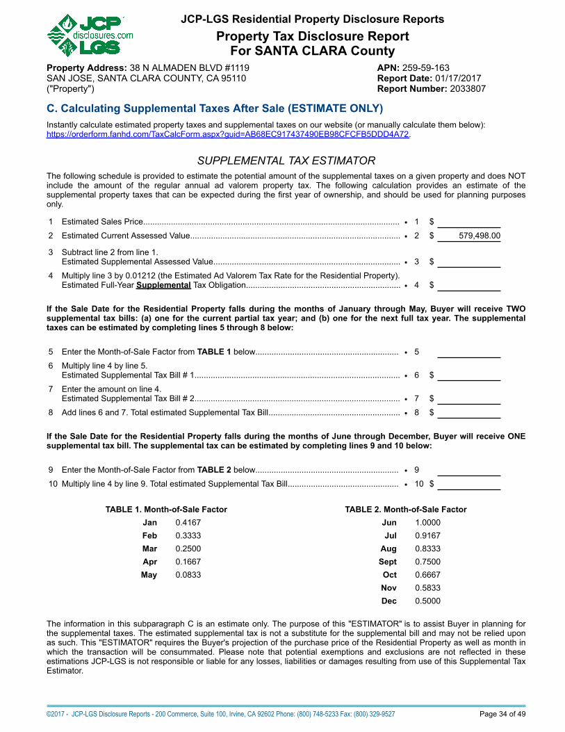
C. Calculating Supplemental Taxes After Sale (ESTIMATE ONLY)Instantly calculate estimated property taxes and supplemental taxes on our website (or manually calculate them below):https://orderform.fanhd.com/TaxCalcForm.aspx?guid=AB68EC917437490EB98CFCFB5DDD4A72.
SUPPLEMENTAL TAX ESTIMATORThe following schedule is provided to estimate the potential amount of the supplemental taxes on a given property and does NOTinclude the amount of the regular annual ad valorem property tax. The following calculation provides an estimate of thesupplemental property taxes that can be expected during the first year of ownership, and should be used for planning purposesonly.
1 Estimated Sales Price............................................................................................................... • 1 $
2 Estimated Current Assessed Value........................................................................................... • 2 $ 579,498.00
3 Subtract line 2 from line 1.Estimated Supplemental Assessed Value.................................................................................
•
3
$
4 Multiply line 3 by 0.01212 (the Estimated Ad Valorem Tax Rate for the Residential Property).Estimated Full-Year Supplemental Tax Obligation...................................................................
•
4
$
If the Sale Date for the Residential Property falls during the months of January through May, Buyer will receive TWOsupplemental tax bills: (a) one for the current partial tax year; and (b) one for the next full tax year. The supplementaltaxes can be estimated by completing lines 5 through 8 below:
5 Enter the Month-of-Sale Factor from TABLE 1 below.............................................................. • 5
6 Multiply line 4 by line 5.Estimated Supplemental Tax Bill # 1.........................................................................................
•
6
$
7 Enter the amount on line 4.Estimated Supplemental Tax Bill # 2.........................................................................................
•
7
$
8 Add lines 6 and 7. Total estimated Supplemental Tax Bill......................................................... • 8 $
If the Sale Date for the Residential Property falls during the months of June through December, Buyer will receive ONEsupplemental tax bill. The supplemental tax can be estimated by completing lines 9 and 10 below:
9 Enter the Month-of-Sale Factor from TABLE 2 below.............................................................. • 9
10 Multiply line 4 by line 9. Total estimated Supplemental Tax Bill................................................ • 10 $
TABLE 1. Month-of-Sale Factor TABLE 2. Month-of-Sale FactorJan 0.4167 Jun 1.0000Feb 0.3333 Jul 0.9167Mar 0.2500 Aug 0.8333Apr 0.1667 Sept 0.7500May 0.0833 Oct 0.6667
Nov 0.5833 Dec 0.5000
The information in this subparagraph C is an estimate only. The purpose of this "ESTIMATOR" is to assist Buyer in planning forthe supplemental taxes. The estimated supplemental tax is not a substitute for the supplemental bill and may not be relied uponas such. This "ESTIMATOR" requires the Buyer's projection of the purchase price of the Residential Property as well as month inwhich the transaction will be consummated. Please note that potential exemptions and exclusions are not reflected in theseestimations JCP-LGS is not responsible or liable for any losses, liabilities or damages resulting from use of this Supplemental TaxEstimator.
©2017 - JCP-LGS Disclosure Reports - 200 Commerce, Suite 100, Irvine, CA 92602 Phone: (800) 748-5233 Fax: (800) 329-9527 Page 34 of 49
JCP-LGS Residential Property Disclosure ReportsProperty Tax Disclosure Report
For SANTA CLARA CountyProperty Address: 38 N ALMADEN BLVD #1119 APN: 259-59-163SAN JOSE, SANTA CLARA COUNTY, CA 95110 Report Date: 01/17/2017("Property") Report Number: 2033807

Part 6. State Responsibility Area Fire Prevention FeePursuant to Chapter 1.5 (commencing with Section 4210) to Part 2 of Division 4 of the Public Resources Code, the State ofCalifornia shall charge an annual "Fire Prevention Benefit Fee" ("Benefit Fee") on each eligible habitable structure on a parcel thatis within a State Responsibility Area ("SRA") as defined in Section 4102 of the Public Resources Code, commencing with the2011-2012 fiscal year. For an explanation of the SRA, refer to page 8 of the Natural Hazard Disclosure Report, under "WildlandFire Area (State Responsibility Area)". The Fee Amount and a Fee Exemption (explained below) were implemented in anemergency regulation adopted January 23, 2012 by the State Board of Forestry and Fire Protection ("Board").
Fee Amount: A Benefit Fee of one hundred fifty-two dollars and thirty-three cents ($152.33) shall be charged on each habitablestructure within an SRA, including single-family homes, multi-dwelling structures, mobile and manufactured homes, andcondominiums. This is not a "per parcel" fee, but a levy on each structure (if any) on the parcel within an SRA which the Statedetermines to be habitable.
Fee Exemption: Property owners of habitable structures within a SRA and also within the boundaries of a local agency thatprovides fire protection services shall receive a fee reduction of thirty-five dollars ($35) per habitable structure.
Date Due and Late Payment PenaltiesThe fee shall be collected annually by the State Board of Equalization ("BOE"), and is due and payable 30 days fromthe date of assessment by the BOE. If not paid when due and payable, a penalty of twenty percent (20%) of the feedetermined to be due shall be added to the amount due and payable for EACH 30-day period in which the fee remainsunpaid.
The fees collected, other than that retained by the BOE necessary for payment of refunds and expenses incurred in the collectionof the fee, shall be deposited into the State Responsibility Area Fire Prevention Fund in the State Treasury. This Fund shall beused by the Board and the Department of Forestry and Fire Protection ("CalFire") to finance the cost of specified fire preventionactivities that will benefit the owners within the SRA who are required to pay the fee, including such activities as public educationprograms and local fire prevention projects to reduce fire risk in SRAs.
On July 1, 2013, and annually thereafter, the Board shall adjust the annual amount of the Fire Prevention Fee to reflect thepercentage of change in the average annual value of a specified standard price index as reported by the Department of Finance.Commencing with the 2012-13 fiscal year, if there are sufficient amounts of moneys in the SRA Fire Prevention Fund to financethe costs of specified fire prevention activities for a fiscal year, the BOE would be prohibited from collecting the fee for that fiscalyear.
Appeals Process: A person from whom the Benefit Fee is to be due may petition for a redetermination of whether this feerequirement applies to the Property. To appeal, the owner must submit within 30 days after the date of service of the determinationa written petition stating the specific grounds upon which the appeal is founded and include supporting documentation. Thepetition must be sent to the address indicated by CalFire which may be the address of CalFire's Designated Fee Administrator.
Database Date: July 2016This Property IS NOT located in a State Responsibility Area.
©2017 - JCP-LGS Disclosure Reports - 200 Commerce, Suite 100, Irvine, CA 92602 Phone: (800) 748-5233 Fax: (800) 329-9527 Page 35 of 49
JCP-LGS Residential Property Disclosure ReportsProperty Tax Disclosure Report
For SANTA CLARA CountyProperty Address: 38 N ALMADEN BLVD #1119 APN: 259-59-163SAN JOSE, SANTA CLARA COUNTY, CA 95110 Report Date: 01/17/2017("Property") Report Number: 2033807

Part 7. Private Transfer Fee AdvisoryPrivate Transfer Fee. This is a fee imposed by a private entity such as a property developer, home builder, or homeownerassociation, when a property within a certain type of subdivision is sold or transferred. (It is commonly known as a "PrivateTransfer Tax".) It is NOT the same as a city or county Documentary Transfer Tax. A Private Transfer Fee may apply in addition togovernment Documentary Transfer Taxes that are due upon sale or transfer of the Property.
Transfer Fee Defined. California Civil Code Section 1098 defines a "Transfer Fee".Effective January 1, 2008, if the payment of any Transfer Fee is required in the sale or transfer of the Property, Civil CodeSection 1102.6e requires Seller to notify Buyer of the existence of the fee and to disclose certain specific informationabout the fee.How to Determine the Existence of a Transfer Fee. If a Transfer Fee does exist affecting the Property, the document creatingthe fee may be on file with the County Recorder as a notice recorded against the Property and should be disclosed in thepreliminary (title) report on the Property. However, the preliminary (title) report will merely disclose the existence of the documentsaffecting title, not the content of the documents. The title of a document may also not be sufficient to disclose that a Transfer Feeis included in its terms. Accordingly Seller should (a) request the title company which issued the preliminary (title) report to providecopies of the documents shown as "exceptions," and (b) review each document to determine if it contains a Transfer Fee.
Parties are advised that documents regarding any Transfer Fee should be obtained early in the sale process in order toavoid delays in the transaction process and to ensure full disclosure as required by law.
To determine if the Property is subject to a Transfer Fee, OBTAIN COPIES OF ALL OF THE EXCEPTIONS LISTED ONTHE PRELIMINARY (TITLE) REPORT FROM THE TITLE COMPANY AND READ THEM TO DETERMINE IF ANYTRANSFER FEES ARE APPLICABLE.
END OF TAX DISCLOSURE REPORT SECTIONSee Terms and Conditions at end of this Report.
©2017 - JCP-LGS Disclosure Reports - 200 Commerce, Suite 100, Irvine, CA 92602 Phone: (800) 748-5233 Fax: (800) 329-9527 Page 36 of 49
JCP-LGS Residential Property Disclosure ReportsProperty Tax Disclosure Report
For SANTA CLARA CountyProperty Address: 38 N ALMADEN BLVD #1119 APN: 259-59-163SAN JOSE, SANTA CLARA COUNTY, CA 95110 Report Date: 01/17/2017("Property") Report Number: 2033807
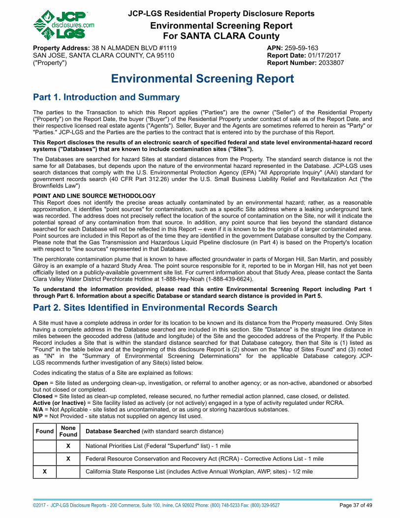
Environmental Screening ReportPart 1. Introduction and SummaryThe parties to the Transaction to which this Report applies ("Parties") are the owner ("Seller") of the Residential Property("Property") on the Report Date, the buyer ("Buyer") of the Residential Property under contract of sale as of the Report Date, andtheir respective licensed real estate agents ("Agents"). Seller, Buyer and the Agents are sometimes referred to herein as "Party" or"Parties." JCP-LGS and the Parties are the parties to the contract that is entered into by the purchase of this Report.
This Report discloses the results of an electronic search of specified federal and state level environmental-hazard recordsystems ("Databases") that are known to include contamination sites ("Sites").The Databases are searched for hazard Sites at standard distances from the Property. The standard search distance is not thesame for all Databases, but depends upon the nature of the environmental hazard represented in the Database. JCP-LGS usessearch distances that comply with the U.S. Environmental Protection Agency (EPA) "All Appropriate Inquiry" (AAI) standard forgovernment records search (40 CFR Part 312.26) under the U.S. Small Business Liability Relief and Revitalization Act ("theBrownfields Law")
POINT AND LINE SOURCE METHODOLOGYThis Report does not identify the precise areas actually contaminated by an environmental hazard; rather, as a reasonableapproximation, it identifies "point sources" for contamination, such as a specific Site address where a leaking underground tankwas recorded. The address does not precisely reflect the location of the source of contamination on the Site, nor will it indicate thepotential spread of any contamination from that source. In addition, any point source that lies beyond the standard distancesearched for each Database will not be reflected in this Report -- even if it is known to be the origin of a larger contaminated area.Point sources are included in this Report as of the time they are identified in the government Database consulted by the Company.Please note that the Gas Transmission and Hazardous Liquid Pipeline disclosure (in Part 4) is based on the Property's locationwith respect to "line sources" represented in that Database.
The perchlorate contamination plume that is known to have affected groundwater in parts of Morgan Hill, San Martin, and possiblyGilroy is an example of a hazard Study Area. The point source responsible for it, reported to be in Morgan Hill, has not yet beenofficially listed on a publicly-available government site list. For current information about that Study Area, please contact the SantaClara Valley Water District Perchlorate Hotline at 1-888-Hey-Noah (1-888-439-6624).
To understand the information provided, please read this entire Environmental Screening Report including Part 1through Part 6. Information about a specific Database or standard search distance is provided in Part 5.
Part 2. Sites Identified in Environmental Records SearchA Site must have a complete address in order for its location to be known and its distance from the Property measured. Only Siteshaving a complete address in the Database searched are included in this section. Site "Distance" is the straight line distance inmiles between the geocoded address (latitude and longitude) of the Site and the geocoded address of the Property. If the PublicRecord includes a Site that is within the standard distance searched for that Database category, then that Site is (1) listed as"Found" in the table below and at the beginning of this disclosure Report is (2) shown on the "Map of Sites Found" and (3) notedas "IN" in the "Summary of Environmental Screening Determinations" for the applicable Database category. JCP-LGS recommends further investigation of any Site(s) listed below.
Codes indicating the status of a Site are explained as follows:
Open = Site listed as undergoing clean-up, investigation, or referral to another agency; or as non-active, abandoned or absorbedbut not closed or completed.Closed = Site listed as clean-up completed, release secured, no further remedial action planned, case closed, or delisted.Active (or Inactive) = Site facility listed as actively (or not actively) engaged in a type of activity regulated under RCRA.N/A = Not Applicable - site listed as uncontaminated, or as using or storing hazardous substances.N/P = Not Provided - site status not supplied on agency list used.
Found NoneFound Database Searched (with standard search distance)
X National Priorities List (Federal "Superfund" list) - 1 mile
X Federal Resource Conservation and Recovery Act (RCRA) - Corrective Actions List - 1 mile
X California State Response List (includes Active Annual Workplan, AWP, sites) - 1/2 mile
©2017 - JCP-LGS Disclosure Reports - 200 Commerce, Suite 100, Irvine, CA 92602 Phone: (800) 748-5233 Fax: (800) 329-9527 Page 37 of 49
JCP-LGS Residential Property Disclosure ReportsEnvironmental Screening Report
For SANTA CLARA CountyProperty Address: 38 N ALMADEN BLVD #1119 APN: 259-59-163SAN JOSE, SANTA CLARA COUNTY, CA 95110 Report Date: 01/17/2017("Property") Report Number: 2033807
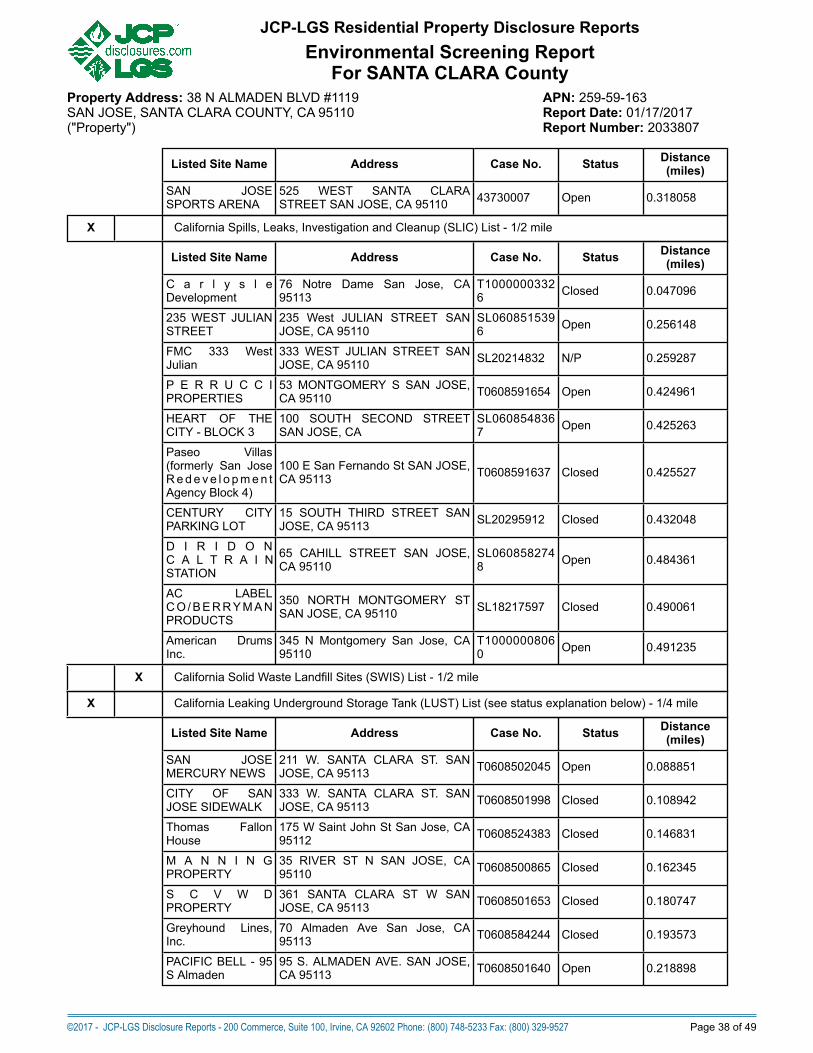
Listed Site Name Address Case No. Status Distance(miles)
SAN JOSESPORTS ARENA
525 WEST SANTA CLARASTREET SAN JOSE, CA 95110 43730007 Open 0.318058
X California Spills, Leaks, Investigation and Cleanup (SLIC) List - 1/2 mile
Listed Site Name Address Case No. Status Distance(miles)
C a r l y s l eDevelopment
76 Notre Dame San Jose, CA95113
T10000003326 Closed 0.047096
235 WEST JULIANSTREET
235 West JULIAN STREET SANJOSE, CA 95110
SL0608515396 Open 0.256148
FMC 333 WestJulian
333 WEST JULIAN STREET SANJOSE, CA 95110 SL20214832 N/P 0.259287
P E R R U C C IPROPERTIES
53 MONTGOMERY S SAN JOSE,CA 95110 T0608591654 Open 0.424961
HEART OF THECITY - BLOCK 3
100 SOUTH SECOND STREETSAN JOSE, CA
SL0608548367 Open 0.425263
Paseo Villas(formerly San JoseRedeve l o pmen tAgency Block 4)
100 E San Fernando St SAN JOSE,CA 95113 T0608591637 Closed 0.425527
CENTURY CITYPARKING LOT
15 SOUTH THIRD STREET SANJOSE, CA 95113 SL20295912 Closed 0.432048
D I R I D O NC A L T R A I NSTATION
65 CAHILL STREET SAN JOSE,CA 95110
SL0608582748 Open 0.484361
AC LABELCO/BERRYMANPRODUCTS
350 NORTH MONTGOMERY STSAN JOSE, CA 95110 SL18217597 Closed 0.490061
American DrumsInc.
345 N Montgomery San Jose, CA95110
T10000008060 Open 0.491235
X California Solid Waste Landfill Sites (SWIS) List - 1/2 mile
X California Leaking Underground Storage Tank (LUST) List (see status explanation below) - 1/4 mile
Listed Site Name Address Case No. Status Distance(miles)
SAN JOSEMERCURY NEWS
211 W. SANTA CLARA ST. SANJOSE, CA 95113 T0608502045 Open 0.088851
CITY OF SANJOSE SIDEWALK
333 W. SANTA CLARA ST. SANJOSE, CA 95113 T0608501998 Closed 0.108942
Thomas FallonHouse
175 W Saint John St San Jose, CA95112 T0608524383 Closed 0.146831
M A N N I N GPROPERTY
35 RIVER ST N SAN JOSE, CA95110 T0608500865 Closed 0.162345
S C V W DPROPERTY
361 SANTA CLARA ST W SANJOSE, CA 95113 T0608501653 Closed 0.180747
Greyhound Lines,Inc.
70 Almaden Ave San Jose, CA95113 T0608584244 Closed 0.193573
PACIFIC BELL - 95S Almaden
95 S. ALMADEN AVE. SAN JOSE,CA 95113 T0608501640 Open 0.218898
©2017 - JCP-LGS Disclosure Reports - 200 Commerce, Suite 100, Irvine, CA 92602 Phone: (800) 748-5233 Fax: (800) 329-9527 Page 38 of 49
JCP-LGS Residential Property Disclosure ReportsEnvironmental Screening Report
For SANTA CLARA CountyProperty Address: 38 N ALMADEN BLVD #1119 APN: 259-59-163SAN JOSE, SANTA CLARA COUNTY, CA 95110 Report Date: 01/17/2017("Property") Report Number: 2033807

CLOSED SITES REMAIN OFFICIALLY LISTED: All Sites listed on the State's Leaking Underground Storage Tank InformationSystem (LUSTIS) have been identified to have had a leaking storage tank. Many LUST Sites have been cleaned up and theircases "Closed", and this is noted above if applicable. Parties should be aware that LUST Sites remain in the LUSTIS databaseeven after they have been closed, and are included in this Report if found by our search. Leaking underground storage tanks arethe most common type of contamination.
Storage tank leaks are often less extensive than other types of contamination releases and usually do not extend beyond the realproperty on which the tank is located. For specific information about a Site listed above, please see Part 5 of this Reportand contact the agency responsible for maintaining that Database.
PART 3. Sites Missing Key Location InformationMany environmental hazard Sites in the Databases searched have incomplete or inaccurate address information. Those Sitescannot be precisely or reliably located and could potentially be anywhere in the Property's city, county, or state. They are,therefore, considered "unlocatable".
A sample of unlocatable sites that may be in the vicinity is listed below. A full list of ALL unlocatable California sites that include azip code is available at the web address below:http://www.firstamprs.com/sites/default/files/Current_List_of_Unlocatable_Sites_by_Zip_Code.xlsx
Status codes for the unlocatable Sites are the same as noted above for the Sites "Found".
No. Site Name Address Case No. Status Database1 BLOCK 2 CITY OF SAN JOSE
PARKING LOT8 EAST SAN FERNANADO STREET SAN JOSE, CA95113
SL0608508545 Closed CA_SLIC
2 Diridon Station JV W Santa Clara St && Delmas Ave San Jose, CA95113
T10000009352 Open CA_SLIC
3 Insight Realty - College ParkParcel 2
Guadalupe Parkway && Ryland Street San Jose, CA95110
T10000007661 Open CA_SLIC
4 AMERICAN CAN PACKAGINGINC
1598 S FIRST ST, SAN JOSE, CA95110 CAD990768871 Active FED_RCRA_COR
5 Avis Budget 2255 && 2253 Airport Boulevard San Jose, CA 95110 T10000002846 Closed CA_SLIC
6 BRANDENBURG-BUTTERS 153 WEST JULIAN ST SAN JOSE, CA 95110 SL18218598 Closed CA_SLIC
7 FORMER ALL STICK ANDGEARS
1697 Pomona Avenue SAN JOSE, CA 95110 T0608535747 N/P CA_SLIC
8 Guadalupe River Project -GUADALUPE RIVER PROJECT
WILLOW STREET && LELONG AVENUE SANJOSE, CA 95110
T10000003264 Closed CA_SLIC
9 PIER 64/MISSION BAY VICINITY OF PIER 64 SAN FRANCISCO, CA 95110 SL18397817 Open CA_SLIC
10 San Jose Transit Mall Devine Street San Jose, CA 95110 T10000008026 Open CA_SLIC
11 SJC TERMINAL A 1701 Airport Blvd SAN JOSE, CA 95110 T0608591655 Closed CA_SLIC
12 Bay Transmissions 1474 Monterey Hwy San Jose, CA 95110 T0608501631 Closed CA_LUST
13 PG&E Substation A 17 Otterson St San Jose, CA 95110 T0608521441 Closed CA_LUST
14 Rebar Spacer Block Co. 1400 State St San Jose, CA 95110 T0608501092 Closed CA_LUST
15 REGAL #423 827 1ST st. SAN JOSE, CA 95110 T0608500589 Open CA_LUST
16 Salamoni Property 933 King Rd San Jose, CA 95110 T0608503500 Closed CA_LUST
17 SAN JOSE ARENA RITCHEYPARCEL
60 MONTGOTMERY ST N SAN JOSE, CA 95110 T0608501981 Closed CA_LUST
18 SCV PARAMEDICS SJAMBULANCE
58 AUTUMN ST N SAN JOSE, CA 95110 T0608500140 Closed CA_LUST
19 SCVTA RYLAND STREETPROPERTY
UNKNOWN RYLAND ST SAN JOSE, CA 95110 T0608501218 Closed CA_LUST
20 Spreckles Sanitary Station 3288 Spreckles Ave San Jose, CA 95110 T0608528407 Closed CA_LUST
21 TULLY/KENOGA LIBRARY &BALL FIELDS
880 TULLY ROAD SAN JOSE, CA 95110 T0608519644 Closed CA_LUST
22 Moyer chemical 1300,1310, 1336 Old Bayshore Hwy San Jose, CA95112
60001663 Open CA_DTSC_RESPONSE
23 PEPPER LANE 1931 MONTEREY HWY SAN JOSE, CA 95112 43200020 Closed CA_DTSC_RESPONSE
24 TOWN & COUNTRY VILLAGESHOPPING CENTER
2980 && 3030 STEVENS CREEK BOULEVARD SANJOSE, CA 95113
43590001 Open CA_DTSC_RESPONSE
©2017 - JCP-LGS Disclosure Reports - 200 Commerce, Suite 100, Irvine, CA 92602 Phone: (800) 748-5233 Fax: (800) 329-9527 Page 39 of 49
JCP-LGS Residential Property Disclosure ReportsEnvironmental Screening Report
For SANTA CLARA CountyProperty Address: 38 N ALMADEN BLVD #1119 APN: 259-59-163SAN JOSE, SANTA CLARA COUNTY, CA 95110 Report Date: 01/17/2017("Property") Report Number: 2033807

25 169 E BROKAW RD 169 E BROKAW RD SAN JOSE, CA 95112 SL0608505537 Closed CA_SLIC
26 Art Cleaners 400 East Santa Clara Street San Jose, CA 95113 T0608578883 Open CA_SLIC
27 Caltrans 10th St 10th Street && Hwy 101 San Jose, CA 95112 T10000008021 Open CA_SLIC
28 Deluxe Cleaners/CIVIC PLAZA 200 E. Santa Clara Street SAN JOSE, CA 95113 SL0608520959 Open CA_SLIC
29 DR. EU BUILDING 35 && 43 SANTA CLARA ST E SAN JOSE, CA95113
SLT2O287178 Open CA_SLIC
30 Housing for Independent People 1072/1082 Vermont St San Jose, CA 95126 T10000007927 Open CA_SLIC
©2017 - JCP-LGS Disclosure Reports - 200 Commerce, Suite 100, Irvine, CA 92602 Phone: (800) 748-5233 Fax: (800) 329-9527 Page 40 of 49
JCP-LGS Residential Property Disclosure ReportsEnvironmental Screening Report
For SANTA CLARA CountyProperty Address: 38 N ALMADEN BLVD #1119 APN: 259-59-163SAN JOSE, SANTA CLARA COUNTY, CA 95110 Report Date: 01/17/2017("Property") Report Number: 2033807
PART 4. Oil & Gas Well Locations Within 1/4 Mile Of PropertyNo oil or gas well locations were identified within a radius of one-fourth (1/4) of one (1) mile of the Residential Property,based on a search of valid geographic coordinates contained in the current Statewide All Wells Database maintained bythe California Department of Conservation, Division of Oil, Gas and Geothermal Resources (DOGGR) ("All WellsDatabase").Buyer is advised that additional wells may exist in the area of the Property which are not contained in the All WellsDatabase. Wells that do not have valid geographic coordinates in the All Wells Database are not disclosed in this Report.The physical property boundaries of well locations and the Property are not factored into the calculation of the specifiedsearch radius.
EXPLANATION: The All Wells Database includes approximately 230,000 well location records. This database is searched for welllocations within one-fourth (1/4) of one (1) mile around the geocoded point representing the Residential Property. Well locations, ifany, within the specified parameters are listed in the table above.
Of the approximately 230,000 wells identified in the All Wells Database, 105,000 are classified as new, active, or idle in the latestStatewide All Wells Database release. The majority of remaining wells have been sealed under supervision of the DOGGR. Asmaller number have been deserted and have no known responsible operator.
California has established laws with respect to well drilling, operation, maintenance, and abandonment to "prevent, as far aspossible, damage to life, health, property, and natural resources; damage to underground oil and gas deposits from infiltratingwater and other causes; loss of oil, gas, or reservoir energy, and damage to underground and surface waters suitable for irrigationor domestic purposes by the infiltration of, or the addition of, detrimental substances." (California Public Resources Code §3106).
The DOGGR is responsible for maintenance of orphaned wells. To defray the maintenance costs, oil companies pay the State 4.3cents per barrel a year. A portion of this assessment funds the Orphan Well Plugging Fund ("Fund") with an annual $1 millionbudget. Since its inception in the 1970's, the Fund has facilitated the plugging of wells by hired contractors. The selection processfor wells to be plugged considers numerous factors including, but are not limited to, the proximity of wells to populated areas, theamount of pressure in well reservoirs, and other hazards.
For a complete listing and explanation of well status codes, visit the following DOGGR web page:http://www.conservation.ca.gov/dog/maps/Pages/GISMapping2.aspx
FOR MORE INFORMATION: Ownership information of oil, gas, mineral, geothermal and other subsurface rights regarding theResidential Property may be disclosed in a preliminary (title) report or title commitment. The DOGGR does not use the CountyAssessor Parcel Number or site address to locate wells or leases, and therefore, the APN and address cannot be used todetermine if there is a well on a specific property. To help tell if there is a well on a property, oilfield maps may be available on theDOGGR website (http://www.conservation.ca.gov/dog/maps/Pages/GISMapping2.aspx). In addition, the DOGGR Online MappingSystem (http://maps.conservation.ca.gov/doms/doms-app.html) allows users to search well locations by API Number, PropertyAddress, Geographic Coordinates, or Field Name. For detailed information about a specific well, reference the unique "APINumber" that the DOGGR has assigned to it. The DOGGR website provides an online well search by API number athttp://opi.consrv.ca.gov/opi/opi.dll.
©2017 - JCP-LGS Disclosure Reports - 200 Commerce, Suite 100, Irvine, CA 92602 Phone: (800) 748-5233 Fax: (800) 329-9527 Page 41 of 49
JCP-LGS Residential Property Disclosure ReportsEnvironmental Screening Report
For SANTA CLARA CountyProperty Address: 38 N ALMADEN BLVD #1119 APN: 259-59-163SAN JOSE, SANTA CLARA COUNTY, CA 95110 Report Date: 01/17/2017("Property") Report Number: 2033807
Part 5. NPMS Gas Transmission and Hazardous Liquid Pipelines Within 2,000Feet of the Residential PropertyBuyer is advised to carefully review the limitations of the Public Record noted below as to the important limitations regarding theNational Pipeline Mapping System (NPMS) and the NPMS Public Map Viewer used for making this determination. For moreinformation please visit the NPMS Public Map Viewer (https://www.npms.phmsa.dot.gov/PublicViewer/).
EXPLANATION: Proximity to a pipeline does not of itself indicate a safety risk. However, on September 9, 2010, a Pacific Gasand Electric (PG&E) natural gas transmission pipeline exploded in San Bruno, California, causing loss of life and extensiveproperty damage. Following this incident much attention has focused on the presence of natural gas and hazardous liquidpipelines in the vicinity of residential neighborhoods. As a result, PG&E has notified residents and businesses within 2,000 feet ofPG&E's natural gas transmission pipelines about their proximity.
This disclosure covers gas "transmission" and hazardous liquid pipelines only. It is important to note that every home that usesnatural gas is connected to a gas "distribution" pipeline. Distribution pipelines are generally of smaller size and lower pressurethan transmission pipelines. This disclosure does not include distribution pipelines nor is it meant to indicate there is no riskassociated with distribution lines. While proximity to a pipeline does not of itself indicate a safety risk, excavation near a pipelineposes a definite hazard. For this reason, this disclosure includes an advisory about how to spot and avoid buried pipelines on andnear a property.
The U.S. Department of Transportation, Pipeline and Hazardous Materials Safety Administration (PHMSA) administers thenational regulatory program to monitor the transportation of natural gas, liquefied natural gas (LNG), and hazardous liquids bypipeline. PHMSA and the U.S. Office of Pipeline Safety (OPS) maintain a database of pipeline information called the NationalPipeline Mapping System (NPMS) in cooperation with other federal and state governmental agencies and the pipeline industry.The NPMS is created using data compiled from mandatory submissions to PHMSA made by operators of pipelines and LNGplants, and from voluntary submissions made by breakout tank operators. The data is processed by private contractors. Since2002, transmission pipeline and LNG plant facility operators are required to update their submissions annually.
The PHMSA website provides a Public Map Viewer that allows the general public to view pipeline maps in one county at a time.The viewer displays maps and associated data identifying transmission pipelines, LNG plants, and breakout tanks stored in theNPMS database. The data include information about the pipeline commodity (e.g., natural gas or liquid fuel), pipeline operator,agency contact, etc. The Public Map Viewer can be accessed at the following address:https://www.npms.phmsa.dot.gov/PublicViewer/
This pipeline disclosure is based on a proximity search of the gas transmission pipelines and hazardous liquid pipelines depictedin NPMS Public Map Viewer at a scale of approximately 1:24,000. That map scale is the maximum resolution at which pipelinesare displayed. At that map scale one inch on the map equals approximately 2,000 feet on the ground, which is the same scale asregulatory maps required for statutory natural haazard disclosure in California.
This pipeline disclosure is provided as an accommodation and is subject to the following limitations in the Public Record:
• Access to the original digital data in the NPMS database (on which the public maps are based) is restricted to federal, state,and local government agencies (including emergency responders). Pipeline operators are allowed access to their own pipelinedata only.
• Pipeline locations in the NPMS database are accurate to plus or minus 500 feet.• Neither the United States government nor any party involved in the creation and compilation of NPMS data and mapsguarantees the accuracy or completeness of its product.
• Because the NPMS digital data are restricted from public access, any disclosure based on the NPMS Public Map Viewer maybe subject to some positional inaccuracies in addition to those acknowledged by NPMS.
• Neither this disclosure nor NPMS data should ever be used as a substitute for calling "811" -- the federally-mandated "CallBefore You Dig" one-call center -- prior to any digging project.
How to Spot a Pipeline EasementRead the Preliminary Title Report A pipeline right-of-way is a strip of land over and around pipelines where some of the propertyowner's legal rights have been granted to a pipeline company. A right-of-way agreement between the pipeline company and theproperty owner is also called an easement and is usually filed in the public records with property deeds. Rights-of-way andeasements provide a permanent, limited interest in the land that enables the pipeline company to operate, test, inspect, repair,maintain, replace, and protect one or more pipelines on property owned by others. The agreement may vary the rights and widthsof the right-of-way, but generally, the pipeline company's right-of-ways extend 25 feet from each side of a pipeline unless specialconditions exist.
To determine if the Property includes a pipeline right-of-way or easement, OBTAIN COPIES OF ALL OF THEEXCEPTIONS LISTED ON THE PRELIMINARY (TITLE) REPORT FROM THE TITLE COMPANY AND READ THEM.
©2017 - JCP-LGS Disclosure Reports - 200 Commerce, Suite 100, Irvine, CA 92602 Phone: (800) 748-5233 Fax: (800) 329-9527 Page 42 of 49
JCP-LGS Residential Property Disclosure ReportsEnvironmental Screening Report
For SANTA CLARA CountyProperty Address: 38 N ALMADEN BLVD #1119 APN: 259-59-163SAN JOSE, SANTA CLARA COUNTY, CA 95110 Report Date: 01/17/2017("Property") Report Number: 2033807

Call Before You Dig - Every Time! In 2000, the U.S. Department of Transportation and the utility industry created the CommonGround Alliance (CGA), a trade association to work with all industry stakeholders in an effort to prevent damage to undergroundutility infrastructure and ensure public safety and environmental protection. The result is the "Call Before You Dig - 811 Service".Whether you are a homeowner or a professional excavator, every digging job requires a call to "811" - even small projects likeplanting trees or shrubs. If you hit an underground utility line while digging, you can harm yourself or those around you, disruptservice to an entire neighborhood and potentially be responsible for fines and repair costs. One call to 811 gets your undergroundutility lines marked for FREE.
Signs of Buried Pipelines Since pipelines are usually buriedunderground, line markers and warning signs like the ones shownhere are used to indicate their approximate location along thepipeline route. The markers and signs are in high-visibility colors(yellow or orange) and are located at frequent intervals along thepipeline right-of-way. The markers can be found where a pipelineintersects a street, highway, railway, or waterway, and at otherprominent points along the route. The markers display the materialtransported in the line, the name of the pipeline operator, and atelephone number where the operator can be reached in the eventof an emergency. Pumping stations, tank farms, and cleared rights-of-way also help signal that a pipeline is located nearby.
Markers and warning signs only indicate the general location of a pipeline. They cannot be relied upon to indicate the exactposition of the pipeline they mark. Also, the pipeline may not follow a straight course between markers. And, while markers arehelpful in locating pipelines, they are limited in the information they provide. They provide no information, for example, about thedepth or number of pipelines in the vicinity.
EXPLANATION OF THE DATABASES USED IN THIS REPORTThis Report uses the following Databases as of the date specified:
1) NATIONAL PRIORITIES LIST ("NPL" - commonly called "Superfund" or "CERCLIS" site list) as of 12 Sep 2016The National Priorities List is a U.S. Environmental Protection Agency ("USEPA") database which includes Sites where knownreleases or threatened releases of hazardous substances, pollutants, or contaminants have occurred. As a part of theSuperfund cleanup program, the NPL helps the USEPA determine which Sites warrant further investigation to assess humanhealth and environmental risks, identify what remedial actions may be appropriate, notify the public of Sites believed to warrantfurther investigation, and serve notice to potentially responsible parties that the USEPA may initiate remedial action. Some NPLSites encompass relatively large areas. Search Distance: one (1.0) mile. Responsible Agency: USEPA
Public Record: Facilities located in California listed as NPL Status code "A" (Site is Part of NPL Site), "D" (Deleted from theFinal NPL), "F" (Currently on the Final NPL), "P" (Proposed for NPL), "R" (Removed from Proposed NPL), or "W" (Withdrawn)in the Region IX Active CERCLIS database obtained from USEPA. Facilities assigned NPL Status code "N" (Not on the NPL)are not disclosed in this Report.
For More Information: Contact the Environmental Protection Agency Superfund Hotline at (800) 424-9346 to speak with aSuperfund consultant to request information from the individual Site Fact Sheet. This help-line can also provide the telephonenumber of the local Community Relations Coordinator for the Site in question and the location of the local information repositoryfor that Site. The USEPA's official Internet website address is:http://www.epa.gov/superfund/index.htm
2) RESOURCE CONSERVATION & RECOVERY ACT--CORRECTIVE ACTION list ("RCRA-COR") as of 12 Sep 2016.RCRA (pronounced "ric-ra") is a federal law enforced by the U.S. Environmental Protection Agency ("USEPA") that requiressafeguards on the use and disposal of household, municipal, commercial and industrial refuse. The goals of the law are toprotect human health and the environment from the potential hazards of waste disposal, to reduce the amount of wastegenerated, and to ensure that wastes are managed in an environmentally sound manner. Under the Corrective Action program,the USEPA permits and monitors the cleanup of hazardous waste contamination. Search Distance: one (1.0) mile. ResponsibleAgency: USEPA
Public Record: "Subject to Corrective Action" facilities identified using USEPA's RCRAInfo Hazardous Waste Query Form forCalifornia.
For More Information: Contact the Environmental Protection Agency at (800) 424-9346 to speak with a consultant to requestinformation from the individual Site Fact Sheet. The USEPA's official Internet website address is:http://www.epa.gov/enviro/html/rcris/index.html
3) CALIFORNIA ENVIROSTOR STATE RESPONSE list as of 13 Sep 2016.
©2017 - JCP-LGS Disclosure Reports - 200 Commerce, Suite 100, Irvine, CA 92602 Phone: (800) 748-5233 Fax: (800) 329-9527 Page 43 of 49
JCP-LGS Residential Property Disclosure ReportsEnvironmental Screening Report
For SANTA CLARA CountyProperty Address: 38 N ALMADEN BLVD #1119 APN: 259-59-163SAN JOSE, SANTA CLARA COUNTY, CA 95110 Report Date: 01/17/2017("Property") Report Number: 2033807
The State Response list, a part of California's "Envirostor" database, identifies sites of confirmed hazardous materials releaseswhere the Department of Toxic Substances Control ("DTSC") is involved in cleanup activities, either in a lead or oversightcapacity. These confirmed release sites are generally high-priority and high potential risk, according to the DTSC. The StateResponse list includes the sites formerly contained in the "Active Annual Workplan (AWP)" list. Search Distance: 1/2 mile.Responsible Agency: State EPA/DTSC
Public Record: Sites listed as "State Response" under "Site_Facility_Type" in the EnviroStor Cleanup Sites database obtainedfrom the Department of Toxic Substances Control. Please note that a given Site may have more than one record if the Site hasmore than one activity Status or EnviroStor ID assigned to it.
For More Information: Contact the State Environmental Protection Agency Department of Toxic Substances Control at: (916)323-3400
4) SPILLS, LEAKS, INVESTIGATION & CLEANUP list ("SLIC") as of 13 Sep 2016.The California SLIC Program oversees soil and water investigations, corrective actions, and assessments at Sites with currentor historic unauthorized discharges and covers all types of pollutants (such as solvents, petroleum fuels, heavy metals,pesticides, etc.). As of January 1, 2005, all SLIC data is required to be submitted to the Geotracker database of the State WaterResources Control Board ("SWRCB"). Information on individual Sites may be available onlineat http://geotracker.waterboards.ca.gov. Please note that according to the SWRCB, "data is undergoing data cleanup and maycontain errors". Search Distance: 1/2 mile. Responsible Agency: SWRCBPublic Record: Sites identified as "Cleanup Program Site" in the GeoTracker database obtained from the State WaterResources Control Board GeoTracker website.
For More Information: For details about a particular site, please visit GeoTracker at http://geotracker.waterboards.ca.govUsing the Identifier tool and clicking on the site on the graphic map interface, you can access a report that includes the casenumber and contact telephone number for the agency with more information on this site. If you know case number, you mayaccess the record using Case Finder at http://geotracker.waterboards.ca.gov/search.asp.
5) SOLID WASTE INFORMATION SYSTEM list ("SWIS") as of 13 Sep 2016.Solid waste landfill sites vary from state to state and may include active landfills, inactive landfills, incinerators, transfer stations,recycling facilities, and other facilities where solid waste is treated or stored. The California Integrated Waste ManagementBoard ("CIWMB") tracks such Sites via its Solid Waste Information System database. SWIS contains information on facilitytype, regulatory and operational status, type of wastes received, and local enforcement actions. Please note that these Sitesare simply regulated facilities and are not classified as being "contaminated" by the Board. Search Distance: 1/2 mile.Responsible Agency: CIWMB
Public Record: Sites listed in the "SwisGis.txt" database obtained from the California Integrated Waste Management BoardSolid Waste Information System website.
For More Information: Contact the Board's "Solid Waste Information Center" at (916) 341 6320 and ask for the AssociateWaste Management Specialist who should be able to answer some limited general questions. For more information, pleasecontact the CIWMB in Sacramento or visit http://www.calrecycle.ca.gov/SWFacilities/Directory/search.aspx on the Internet.
6) LEAKING UNDERGROUND STORAGE TANK list ("LUST") per GEIMS/GeoTracker Information Management System asof 13 Sep 2016.The LUST database is also known as the "LUFT" database because it includes records of leaking underground fuel tanks.LUSTs may be a significant source of soil and groundwater contamination. The State Water Resources Control Board("SWRCB") maintains a database of LUSTs known as the Leaking Underground Storage Tank Information System ("LUSTIS")which was recently supplanted by the statewide GEIMS/GeoTracker information management system. LUSTIS contains thelocations of all reported LUSTs, as well as the contents and status of the LUSTs. Search Distance: 1/4 mile. ResponsibleAgency: SWRCB
Public Record: Sites identified as "LUST Cleanup Site" in the GeoTracker database obtained from the State Water ResourcesControl Board GeoTracker website.
For More Information: For general questions, telephone the State Water Resources Control Board's Clean Water Desk inSacramento at (866) 480-1028. Information on specific Sites is available at www.swrcb.ca.gov or visit their official Internet siteat http://geotracker.waterboards.ca.gov.
7) CALIFORNIA STATEWIDE ALL WELLS DATABASE as of 07 Oct 2016.The California Division of Oil, Gas, and Geothermal Resources, California Department of Conservation ("DOC"), maintains adatabase of oil, gas and geothermal wells in the state. Of the approximately 230,000 wells identified in the All Wells Database,approximately 105,000 are still in use. The majority of remaining wells have been sealed under supervision of the DOGGR. Asmaller number have been deserted and have no known responsible operator. Search Distance: 1/4 mile. ResponsibleAgency: State Department of Conservation
©2017 - JCP-LGS Disclosure Reports - 200 Commerce, Suite 100, Irvine, CA 92602 Phone: (800) 748-5233 Fax: (800) 329-9527 Page 44 of 49
JCP-LGS Residential Property Disclosure ReportsEnvironmental Screening Report
For SANTA CLARA CountyProperty Address: 38 N ALMADEN BLVD #1119 APN: 259-59-163SAN JOSE, SANTA CLARA COUNTY, CA 95110 Report Date: 01/17/2017("Property") Report Number: 2033807

Public Record: Well locations listed in the Statewide All Wells Database obtained from the Department of Conservation,Division of Oil, Gas and Geothermal Resources.
For More Information: Contact the State Department of Conservation, Division of Oil, Gas and Geothermal Resources at:(916) 445-9686.
8) NATIONAL PIPELINE MAPPING SYSTEM (NPMS) GAS TRANSMISSION AND HAZARDOUS LIQUID PIPELINES as of 31Oct 2016.The National Pipeline Mapping System (NPMS) is a geographic information system (GIS) created by the U.S. Department ofTransportation, Pipeline and Hazardous Materials Safety Administration (PHMSA), Office of Pipeline Safety (OPS) incooperation with other federal and state governmental agencies and the pipeline industry. The NPMS is created using datacompiled from mandatory submissions made by pipeline, LNG (Liquid Natural Gas) plant operators, and voluntary submissionsmade by breakout tank operators. The data is processed by private contractors. Neither the United States government nor anyparty involved in the creation and compilation of NPMS data and maps guarantees its accuracy or completeness. NPMS datashould be considered no more accurate than +/- 500 feet and must never be used as a substitute for contacting the appropriateone-call center prior to digging. PHMSA restricts access to the NPMS to federal, state, and local government agencies(including emergency responders). Pipeline operators are allowed access to their own pipeline data only. NPMS Public MapViewer (https://www.npms.phmsa.dot.gov/PublicViewer/) allows the general public to view available data one county at a timeand at a limited zoom level in accordance with PHMSA's security policy. Search Distance: 2,000 feet. Responsible Agency:PHMSA
Public Record: Gas transmission pipelines and hazardous liquid pipelines as depicted on the NPMS Public Map Viewer at ascale of 1:24,000.
For More Information: To identify a specific pipeline owner/operator, please use the NPMS Public Map Viewer at the URLprovided above. For policy and technical questions regarding NPMS, please contact PHMSA.
WANT MORE INFORMATION?There is no single government agency that handles information for all contaminated Sites. Multiple agencies are responsible fororganizing clean-up efforts at different types of Sites. Each generally maintains files on the Sites they oversee with information onthe type and extent of contamination, clean-up efforts etc. There is also the possibility that the file may have no additionalinformation. For general information, refer to the discussions in this Report. If your question isn't answered there, call us hereat JCP-LGS. We will try and answer them for you.
In the list of databases above, there is the name and telephone number of the agency overseeing that site. Agencies are limited toanswering general questions. NOTE! Additional information on a site may be limited and the government agency you contact willnot venture opinions.
How to Obtain Generalized Environmental InformationBrochures published by the Environmental Protection Agency (EPA) are a good source of general information. County healthdepartments may have a health and safety officer or a "hazmat" (hazardous materials) specialist that can answer generalquestions also. The telephone number for the local Department of Health should be listed in the telephone book.
• Environmental Protection Agency Drinking Water Hotline: (800) 426-4791• Federal Environmental Protection Agency Public Information Office: (866) 372-9378• California Environmental Protection Agency: (916) 445-3846BACKGROUND ABOUT ENVIRONMENTAL HAZARDSJCP-LGS provides a consumer guide titled, "Guide to Environmental Hazards", as a supplement to this environmental Report.This "plain-English" supplement discusses and explains environmental hazards and what they mean for residential propertytransactions. The guide may be freely downloaded (as a PDF document) and printed from our website at the following address:http://www.disclosures.com/sites/default/files/fanhdguidetoenvironmentalhazards.pdf
©2017 - JCP-LGS Disclosure Reports - 200 Commerce, Suite 100, Irvine, CA 92602 Phone: (800) 748-5233 Fax: (800) 329-9527 Page 45 of 49
JCP-LGS Residential Property Disclosure ReportsEnvironmental Screening Report
For SANTA CLARA CountyProperty Address: 38 N ALMADEN BLVD #1119 APN: 259-59-163SAN JOSE, SANTA CLARA COUNTY, CA 95110 Report Date: 01/17/2017("Property") Report Number: 2033807

TERMS and CONDITIONSACCEPTANCE OR USE OF THIS REPORT CONSTITUTES APPROVAL AND ACCEPTANCE OF THE TERMS, CONDITIONS, AND LIMITATIONSSTATED HEREIN.
The Report ("Report") is subject to each of the following Terms and Conditions. Each Recipient (defined below) of the Report agrees that the Report issubject to the following Terms and Conditions, and each Recipient agrees to be bound by such. Use of this Report by any Recipient constitutes acceptanceof the Terms and Conditions to the Report. The Terms and Conditions below are incorporated by this reference into the Report. This Report is not aninsurance policy.
This Report is made for the real property specifically described in the Report (the “Property”) and solely for the transaction for which it was originallypurchased ("Transaction"). The Property shall not include any property beyond the boundaries of the real property described in the Report. The Propertyshall not include any structures (whether located on the Property, or not), easements, or any right, title, interest, estate, or easement in any abutting streets,roads, alleys, lanes, ways, or waterways.
IMPORTANT NOTICE: Transferor(s) and transferee(s) shall read the complete Report in its entirety before the close of escrow. A "Signature Page" or"Summary Pages" document may be included in the electronic delivery of this Report. Those documents do not replace the complete Report or remove theneed to read the complete Report, and do not remove the requirement to disclose. The Signature Page and Summary Pages documents are subject to theTerms and Conditions of the complete Report.
A. No Third Party Reliance on This Report. Only the transferor(s) and transferee(s), and their agents/brokers, if any, involved in the Transaction(collectively, the "Recipients") may use and rely on this Report and only after they have paid in full for the Report. While disclosures made on the NaturalHazard Disclosure Statement in the Report may indicate certain risks to the Property, the disclosures are only "…between the transferor, the transferor'sagents, and the transferee, and shall not be used by any other party, including, but not limited to, insurance companies, lenders, or governmentalagencies, for any purpose." Cal. Civil Code section 1103.2, subdivision (g).
B. Seller and Seller’s Agent’s Responsibility of Full Disclosure. Recipients are obligated to make disclosures, and always disclose material facts, thatare within their actual knowledge.
C. Scope of Report. This Report is limited to determining whether the Property is in those specified natural hazard zones and property tax districts, and inproximity to those specified environmental sites (depending on the report product ordered), as defined in the Report. The Report is not a geologic reportor a land survey and no site inspection has been made in producing the Report. JCP-LGS makes no determination, expresses no opinion or view, andassumes no responsibility in this Report concerning the right, entitlement, or ability to develop or improve the Property. JCP-LGS has no informationconcerning whether the Property can be developed or improved. No determination is made and no opinion is expressed, or intended, by this Reportconcerning structures or soils on or outside of the Property, including, without limitation, habitability of structures or the Property, suitability of theProperty for construction or improvement, potential for soil settlement, drainage, soil subsidence, or other soil or site conditions. The Recipient(s) isadvised to consult the local Planning Department to determine whether factors beyond the scope of this Report may limit the transferee(s) ability to useor improve the Property.
The Report is not a title report, and no determination is made and no opinion is expressed, or intended, by this Report as to title to the Property or liensagainst the Property, recorded or otherwise, or whether the Property is comprised of legal lots in conformance with the California Subdivision Map Act orlocal ordinances. The Report is not a property inspection report, and no determination is made and no opinion is expressed, or intended, by this Reportconcerning architectural, structural, mechanical, engineering, or legal matters, or the marketability or value of the Property. JCP-LGS has not conductedany testing or physical or visual examination or inspection of the Property, nor is this Report a substitute for any such testing, physical or visualexamination, or inspection.
D. Tax and Environmental Disclosures (if included in Report). No determination is made and no opinion is expressed, or intended, by the Reportconcerning the existence of property tax liabilities, or the existence of hazardous or toxic materials or substances, or any other defects, on, under, or inproximity to the Property, unless specifically described in the Report. JCP-LGS's total liability for any error or omission in its disclosures relating to taxesand/or environmental matters shall be limited to actual proven damages not to exceed $10,000.
E. JCP-LGS Database Updates. Each database used in this Report is updated by the responsible agency at various intervals. Updates for a database aredetermined by the responsible agency and may be made at any time and without notice. JCP-LGS maintains an update schedule and makes reasonableefforts to use updated information. For these reasons, JCP-LGS reports information as of the date when the database was last updated by JCP-LGS.That date is specified as the "Database Date" for each database.
F. Statutory and Additional Disclosures, Advisories, and Local Addenda (if included in Report). No determination is made and no opinion isexpressed, or intended, by this Report concerning the need to purchase earthquake or flood insurance for the Property. In preparing the Report, JCP-LGS accurately reported on information contained in Government Records. JCP-LGS reviewed and relied upon those Government Records specificallyidentified and described in the Report. JCP-LGS has not reviewed or relied upon any Government Records that are not specifically identified in theReport. JCP-LGS also has not reviewed any plat maps, survey maps, surveyor maps, assessor maps, assessor parcel maps, developer maps, orengineering maps, whether or not such maps have been recorded. No determination is made and no opinion is expressed, or intended, by the Reportconcerning any matters identified in Government Records that were not reviewed by JCP-LGS. Local Addenda, where applicable, are included "AS IS"as an accommodation to the local real estate board that provided the content; JCP-LGS assumes no responsibility for the accuracy of any informationincluded in the Local Addenda.
G. FEMA Flood Determination Certificate (if accompanying the Report). No determination is made and no opinion is expressed, or intended, by theReport concerning the requirement for or cost of flood insurance on the Property. Recipient(s) understands that a lender may require flood insurance tosecure its loan collateral independent of whether FEMA may require flood insurance under the National Flood Insurance Program on a federally backedmortgage. The FEMA Flood Determination Certificate ("Flood Certificate"), which may accompany the Report, is produced by a third-party expertcertified by FEMA to provide Flood Certificates. JCP-LGS assumes no liability for errors in that third-party flood determination.
JCP-LGS Residential Property Disclosure ReportsTerms and Conditions
Property Address: 38 N ALMADEN BLVD #1119 APN: 259-59-163SAN JOSE, SANTA CLARA COUNTY, CA 95110 Report Date: 01/17/2017("Property") Report Number: 2033807
©2017 - JCP-LGS Disclosure Reports - 200 Commerce, Suite 100, Irvine, CA 92602 Phone: (800) 748-5233 Fax: (800) 329-9527 Page 46 of 49
H. Changes to Government Record after Report Date. This Report is issued as of the Report Date identified in the Report. JCP-LGS shall have noobligation to advise any Recipient of any information learned or obtained after the Report Date even if such information would modify or otherwise affectthe Report. Subsequent to JCP-LGS acquisition of Government Records, changes may be made to said Government Records and JCP-LGS is notresponsible for advising the Recipients of any changes. JCP-LGS will update this Report upon request and at no charge during the transaction processfor which this Report was issued, but not to exceed one year from the date of the Report. Likewise, JCP-LGS is not liable for any impact on the Propertythat any change to the Government Records may have.
I. Government Record Sources.JCP-LGS relies upon the Government Records specifically identified in the Report without conducting an independentinvestigation of their accuracy. JCP-LGS assumes no responsibility for the accuracy of the Government Records identified in the Report. JCP-LGSmakes no warranty or representation of any kind, express or implied, with respect to the Report. JCP-LGS expressly disclaims and excludes any and allother express and implied warranties, including, without limitation, warranties of merchantability or fitness for a particular purpose. The JCP-LGS Reportis "AS IS".
J. Limitation of JCP-LGS's Liability
1. JCP-LGS is not responsible for:• Any inaccuracies or incompleteness of the information in the Public Records.• Inaccurate address information provided for the Property.• Any other information not contained in the Public Records as of the Report Date.• Any information which would be disclosed by a physical inspection of the Property.• Any information known by one of the Parties.• The health or risk to humans or animals that may be associated with any of the disclosed hazards.• The costs of investigating or remediating any of the disclosed hazards.
2. Except as otherwise expressly set forth in these Terms and Conditions, JCP-LGS’s total liability and responsibility to all Recipients collectively forany and all liabilities, causes of action, claim or claims, including but not limited to claims for breach of contract or negligence, shall be for actualproven damages only caused directly by JCP-LGS’s error up to a maximum of $100,000. JCP-LGS expressly disclaims any liability for Recipientsindirect, incidental and/or consequential damages, including without limitation lost profits even if such damages are foreseeable. In the event of anyerror, omission or inaccuracy in the JCP-LGS Report for which JCP-LGS is liable, JCP-LGS shall have no duty to defend or pay any attorneys’ fees,costs or expenses incurred by the Recipients, or any of them. The Recipients, and each of them, expressly waive the benefits of California CivilCode Section 2778.
K. Reporting of Risk Elements for Condominium Projects, Planned Unit Developments, and Other Properties with Common or UndividedInterests. Because California’s Residential Natural Hazard Disclosure Law requires disclosure if any portion of the Property is located within a specifiednatural hazard area/zone, the Report must indicate that the subject Property falls within the area/zone if any portion of such a condominium project,planned unit development, or common area is located within a specified hazard area/zone.
L. Governing Law. The Report shall be governed by, and construed in accordance with, the laws of the State of California.
M. Small Claims or Arbitration. This provision constitutes an agreement to arbitrate disputes on an individual basis. Any party may bring an individualaction in small claims court instead of pursuing arbitration. All disputes and claims arising out of or relating to the Report must be resolved by bindingarbitration. This Report to arbitrate includes, but is not limited to, all disputes and claims between JCP-LGS, transferor(s) and transferee(s) and claimsthat arose prior to purchase of the Report. This agreement to arbitrate applies to transferor(s) and transferee(s) successors in interest, assigns, heirs,spouses, and children. As noted above, a party may elect to bring an individual action in small claims court instead of arbitration, so long as the disputefalls within the jurisdictional requirements of small claims court.
Any arbitration must take place on an individual basis, JCP-LGS, transferor(s) and transferee(s) agree that they are waiving any right to a jury trial and tobring or participate in a class, representative, or private attorney general action, and further agree that the arbitrator lacks the power to consider claimsfor injunctive or declaratory relief, or to grant relief effecting anyone other than the individual claimant.
The arbitration is governed by the Commercial Arbitration Rules and the Supplementary Procedures for Consumer Related Disputes (the "AAA Rules")of the American Arbitration Association ("AAA"), as modified by this Agreement, and will be administered by the AAA. Company will pay all AAA filing,administration and arbitrator fees for any arbitration it initiates and for any arbitration initiated by another party for which the value of the claims is$75,000 or less, unless an arbitrator determines that the claims have been brought in bad faith or for an improper purpose, in which case the payment ofAAA fees will be governed by the AAA Rules. A COPY OF THESE RULES IS AVAILABLE FROM THE AAA’S WEB SITE AT WWW.ADR.ORG OR ONREQUEST FROM THE COMPANY. THE ARBITRATION AWARD MAY INCLUDE ATTORNEY’S FEES IF ALLOWED BY FEDERAL, STATE, OROTHER APPLICABLE LAW AND MAY BE ENTERED AS A JUDGMENT IN ANY COURT OF PROPER JURISDICTION.
The arbitration will take place in the same county in which the property covered by the Report is located. The Federal Arbitration Act will govern theinterpretation, applicability and enforcement of this arbitration agreement. This arbitration agreement will survive the termination of this Report.
N. Severability. If any provision of the Terms and Conditions to this Report is determined to be invalid or unenforceable for any reason, then such provisionshall be treated as severed from the remainder of the Terms and Conditions, and shall not affect the validity and enforceability of all of the otherprovisions of the Terms and Conditions.
O. Other Agreements. This Report constitutes the entire, integrated agreement between JCP-LGS and Recipients, and supersedes and replaces all priorstatements, representations, negotiations, and agreements.
END OF REPORT
JCP-LGS Residential Property Disclosure ReportsTerms and Conditions
Property Address: 38 N ALMADEN BLVD #1119 APN: 259-59-163SAN JOSE, SANTA CLARA COUNTY, CA 95110 Report Date: 01/17/2017("Property") Report Number: 2033807
©2017 - JCP-LGS Disclosure Reports - 200 Commerce, Suite 100, Irvine, CA 92602 Phone: (800) 748-5233 Fax: (800) 329-9527 Page 47 of 49

ADDENDUMCITY OF SAN JOSE STREET TREE DISCLOSURE FORM
The City of San Jose ("City") requires the seller or transferor of residential real property ("Property") in the City to disclose to theacquirer of the Property whether the Property fully complies with the City's requirements to have, maintain and if necessary, replacestreet trees pursuant to the San Jose Municipal Code ("SJMC").
13.28.195 Disclosure Obligations Upon Sale or Transfer of a Residential Real PropertyA.Not less than seven (7) business days before the sale or other transfer of residential real property concludes a selling or transferringproperty owner must disclose to the acquiring property owner, on a disclosure form provided by the City, whether the residential realproperty to be sold or transferred fully complies with the City's street tree maintenance and replacement requirements of Sections13.28.130.B and 13.28.190.
B. If the selling or transferring property owner cannot determine whether street trees located on the residential property are substantiallyin compliance with the approved development permits for the property, or the property's approved development permits areinconclusive as to the requirements for the presence and location of street trees on the property, then the following requirements forthe planting and presence of street trees shall apply:1. The property must have one (1) street tree for any adjacent street if it is an interior lot and at least three (3) street trees if it is a
corner lot, unless otherwise modified by the Director in the interest of public safety.2. If the current General Plan requirements for street trees on the property differ from the requirements specified in Subsection B.1,
then the current General Plan requirements shall govern the number and location of street trees required on the property at thetime of sale or transfer. If the property meets the General Plan requirement, then the selling property owner must indicate suchcompliance with the General Plan on the disclosure to the acquiring property owner.
3. All street trees shall be planted in accordance with the requirements of Section 13.28.070.C.Upon a written request, the Director may grant the selling or transferring property owner an exemption in writing from therequirements of this Section if the Director determines in the interest of public safety that planting and maintaining street trees on theresidential property at the time of sale or transfer is not appropriate. Such an exemption does not run with the land and shall not allowany deviations from the disclosure requirements upon residential real property sales or transfers for future sellers or transferors.
To the best of my/our knowledge but without any investigation, I/WE, disclose thatthe street tree(s) on the Property to be sold or transferred and located at San Jose,CA are in the following condition:
1. The property fully complies with the street tree requirements outlined in the SJMC. 2. The property does not have the required number of street trees as required by the SJMC. 3. The property has the required number of street trees but the street trees have not been maintained as required by the SJMC. 4. Seller/Transferor is unaware if the requirements to have and maintain street trees on the Property have been met.
Property Address: San Jose, Santa Clara County, CA
Seller:
Signature(s) Print Name(s) Date
The undersigned hereby acknowledges receipt of a copy of this document.
Buyer:
Signature(s) Print Name(s) Date

ABOUT THE CITY OF SAN JOSÉ STREET TREE ORDINANCETwo changes to San José's Street Tree Ordinance took effect in August 2003 that affect all San José property owners. Street trees arealong the street, usually between the curb and sidewalk, and it is the responsibility of property owners to maintain street trees adjacentto their property.
Tree PruningThe first change allows pruning of street trees without a permit, if the property owner uses a tree service company that has registeredwith the City of San José Department of Transportation. Companies that have registered with the City agree to abide by the City's treepruning standards. A list of currently registered tree companies can be obtained by calling the City Arborist Office at (408) 277-2762, orby accessing the link on the City of San José website at: https://www.sanjoseca.gov/DocumentCenter/View/6692. A trimming permit isnot required when addressing an immediate dangerous public safety condition involving a tree. The City Arborist Office, however, doesneed to be notified of such emergency pruning work within two business days.
Seller Disclosure RequirementThe second change to the ordinance requires a disclosure when residential property within San José is sold. San José requires streettrees in the public right of way. For corner lots, the standard is a minimum of three street trees, while for interior lots between thecorners of a block the standard is at least one tree in the right-of-way. Along with other disclosures that are made during the sale, theseller must disclose to the buyer the status of the property's compliance with the street trees requirement.
If the property owner feels that, for reasons of public safety, there are conditions that may prevent the planting of any of these trees, theproperty owner can contact the City Arborist Office at (408) 277-2762 to have the situation evaluated.
The City of San José's office called "Our City Forest" is a one-stop resource for residents to obtain planting permits, information aboutthe types of street trees, and planting materials, including trees, stakes and root barriers. Our City Forest also provides plantingassistance, if needed, as well as information on proper watering and tree care methods. For more information, contact Our City Forestat (408) 998-7337. Street tree planting permits are also available from the City Arborist Office.
Residents having questions about changes to the Street Tree Ordinance should contact the City of San José Department ofTransportation Arborist Office at (408) 277-2762.
(Information provided by the City of San José, California)


![r Y R G R Y j | W S v R W } r R X S d K U R h Y R g [ J W ... · 9 g ¾ e ^ R W a } n R ¾ e ^ R R u I ] c W T Z T i p [ Y i U x T Z U ~ T i c T Y W U l c T Z U s l [ T14](https://static.fdocuments.in/doc/165x107/5e216c72322dac29f52379e8/r-y-r-g-r-y-j-w-s-v-r-w-r-r-x-s-d-k-u-r-h-y-r-g-j-w-9-g-e-r-w-a-.jpg)