Lummi Nation Road Safety Audit Report · 2016 Prepared by Rowena Yeahquo NW TTAP, Eastern...
19
2016 Prepared by Rowena Yeahquo NW TTAP, Eastern Washington University Lummi Nation Road Safety Audit Report
Transcript of Lummi Nation Road Safety Audit Report · 2016 Prepared by Rowena Yeahquo NW TTAP, Eastern...
2016
Prepared by
Rowena Yeahquo
NW TTAP, Eastern Washington University
Lummi Nation Road Safety Audit Report
RSA REPORT – LUMMI NATION
1
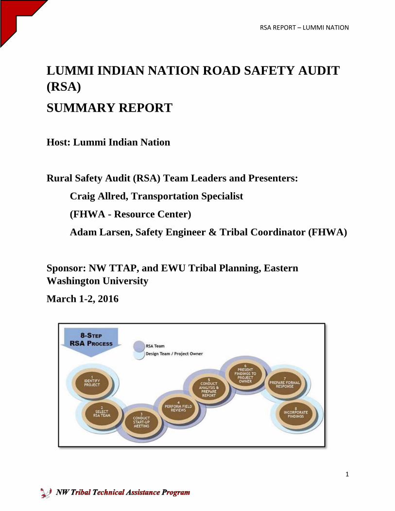
LUMMI INDIAN NATION ROAD SAFETY AUDIT
(RSA)
SUMMARY REPORT
Host: Lummi Indian Nation
Rural Safety Audit (RSA) Team Leaders and Presenters:
Craig Allred, Transportation Specialist
(FHWA - Resource Center)
Adam Larsen, Safety Engineer & Tribal Coordinator (FHWA)
Sponsor: NW TTAP, and EWU Tribal Planning, Eastern
Washington University
March 1-2, 2016
RSA REPORT – LUMMI NATION
2
To Lummi Nation:
The NW Tribal Technical Assistance Program (NW TTAP) is pleased to support the Lummi
Indian Nation Road Safety Audit Workshop that involved participants creating this RSA as
described in this report. The Lummi Indian Nation served as host for this RSA training and
workshop to strengthen community safety and wellness in transportation. The Lummi Nation has
placed a priority on a tribal transportation planning and development that have produced major
accomplishments including the Lummi Shore Road Project, 2008 adoption of the Lummi Nation
Transportation Plan and the Lummi Nation Haxton Way Pedestrian Path/Lighting Project. The
Lummi Nation has a highly professional staff that addresses the priorities for sound
transportation and transportation safety. The Lummi Nation hosted this RSA workshop and
completed the RSA to continue this leadership and progress for a safe community.
The Lummi Nation Transportation Program worked with consultants in 2015 to update their
Tribal Traffic Safety Plan and also partnered with our EWU Tribal Planning Programs in a
Washington Traffic Safety Commission funded demonstration project for data driven Tribal
Transportation Safety. During 2015 Lummi Nation identified the need to hold a Road Safety
Audit workshop as a “next step” in the development and implementation of traffic safety projects
and programs. This request was made to the NW TTAP, and we are very pleased that this RSA
workshop was carried out successfully thanks to the presenters, participants, and the Lummi
Nation. We had strong participation that will strengthen the successful efforts to achieve Target
Zero—no fatalities, no serious injuries, on Lummi Nation reservation roads, and to promote
safety and wellness throughout the reservation. I would like to thank Mr. Craig Allred and Mr.
Adam Larsen from the Federal Highway Administration, and Kurt Vinish, Diane Bern, Matthew
Enders, and tribal council member Henry Cagey for their support in this effort.
The NW TTAP was pleased to support this workshop and RSA report to promote the knowledge
and skills to continue to improve the reservation transportation systems, specifically through safe
roads. We hope that community leaders and staff will build on the knowledge and results of this
workshop, report, and subsequent videos. We are pleased to offer this Lummi Nation RSA
Report as documentation of the process and work of an RSA team, and how it can be applied on
reservations to lead to road safety improvement projects and programs.
Sincerely,
Rowena Yeahquo, Director
NW TTAP
Table of Contents
Cover Page
RSA REPORT – LUMMI NATION
3
Letter of Transmission
Table of Contents
1.0 Introduction to the Road Safety Audit in Transportation Planning.
1.1 RSAs in Transportation Planning and Development
1.2 RSA Training Activities and Workshop Schedule
1.3 RSA Team
2.0 The Lummi Indian Nation RSA
2.1 Identification of Need.
2.2 Site A –Haxton and Slater Road
2.2.1 Useful Features of Intersection
2.2.2. Key Safety Issues
2.2.3. Crash Data
2.2.4. Areas of Concern
2.2.5 Low Cost/Short Term Countermeasures
2.2.6 Long Term Recommendations
2.3 Site B – Lummi Shores Road/Kwina Rd/Marine Road
2.3.1. Useful Features of Intersection
2.3.2. Key Safety Issues
2.3.3. Crash Data
2.3.4. Areas of Concern
2.3.5 Low Cost/Short Term Countermeasures
2.3.6 Mid-Term Recommendations
2.3.7 Long Term Recommendations Options 1-4
3.0 Follow Up Steps in RSA Process
Table of Figures
RSA REPORT – LUMMI NATION
4
Figure (1) Ariel picture of Haxton Way & Slater Road Pg. 4
Figure (2) Ariel picture of Lummi Shores Rd/Kwina Rd/Marine Drive Pg. 4
Figure (3) Map of Collision Data on Lummi Reservation Pg. 6
Figure (4) Intersection of Haxton Way and Slater Road Pg. 7
Figure (5) Green vehicle turning left (south) Pg. 8
Figure (6) Green vehicle turning right (east) Pg. 8
Figure (7) Looking Westbound on Slater Rd. Pg. 8
Figure (8) Looking Eastbound on Slater Rd. Pg. 8
Figure (9) Example of Roundabout on Haxton Way
and Northgate Rd. on Lummi Reservation Pg. 9
Figure (10) Ariel picture of Lummi Shores Rd/Kwina Rd/Marine Drive Pg. 10
Figure (11) Going southeast from Kwina Rd to Lummi Shore Rd. Pg. 10
Figure (12) Marine Drive going West Pg. 11
Figure (13) View going west on Marine Drive Pg. 11
Figure (14) Viewing southwest coming off Marine Pg. 11
Figure (15) Viewing west on Marine Drive toward Y-shaped intersection. Pg. 12
Figure (16) Viewing east on Lummi Shore Rd. Pg. 12
Figure (17) Conceptual design to construct two small roundabouts on
Lummi Shore Rd. Pg. 13
Figure (18) Conceptual design build bridge from Marine Dr. to Lummi Shore Rd. Pg. 14
Figure (19) Conceptual design to excavate and level the area of intersection and build
roundabout. Pg. 15
Figure (20) Rough Design to construct modified roundabout with minimum grade
change. Pg. 16
LUMMI ROAD SAFETY AUDIT REPORT
RSA REPORT – LUMMI NATION
5
1.0 Introduction to the Road Safety Audit in Transportation Planning
A Road Safety Audit (RSA) is a proven countermeasure for improving safety and saving lives by
reducing injuries. The RSA is a formal and independent safety performance review of a road
transportation project by an experienced, multi-disciplinary team of safety professionals,
addressing the safety of all road users. The Lummi Tribe, in an effort to make their
transportation system as safe as possible, initiated a Transportation Safety Plan in 2015.
The Northwest Tribal Technical Program (NW TTAP) arranged a RSA workshop at the Lummi
Reservation in March 2016. This report is the product of that review with the findings and
suggestions for improvements.
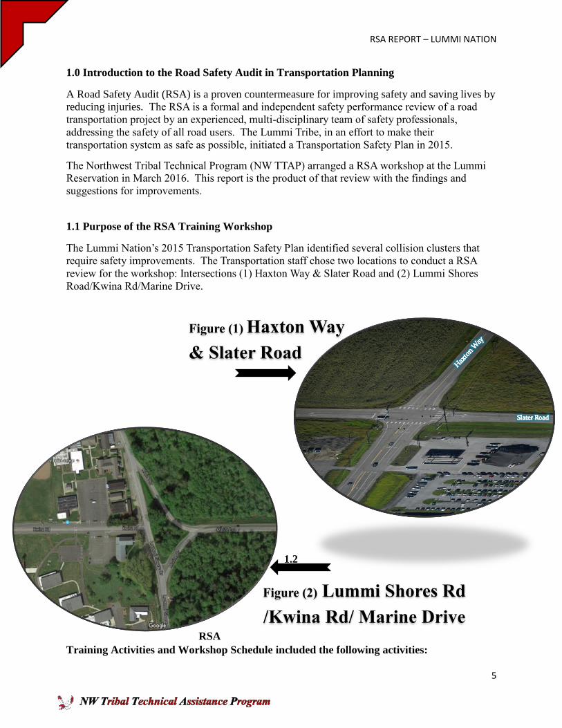
1.1 Purpose of the RSA Training Workshop
The Lummi Nation’s 2015 Transportation Safety Plan identified several collision clusters that
require safety improvements. The Transportation staff chose two locations to conduct a RSA
review for the workshop: Intersections (1) Haxton Way & Slater Road and (2) Lummi Shores
Road/Kwina Rd/Marine Drive.
1.2
RSA
Training Activities and Workshop Schedule included the following activities:
Figure (2) Lummi Shores Rd
/Kwina Rd/ Marine Drive
Figure (1) Haxton Way
& Slater Road
RSA REPORT – LUMMI NATION
6
Field Reviews: Day and Night on March 1- 2, 2016
Stakeholder Meetings on March 1 - 2, 2016 with:
Lummi Nation Planning Department
Lummi Nation Business Council Representatives
Lummi Nation Law Enforcement
Eastern Washington University Student
Parametrix Engineering
Island County
Business Owners and Citizens
Attended Lummi Tribal Planning Department Meeting, March 3, 2016
Delivered RSA Report to Lummi Nation April 2016
1.3 The RSA team consisted of the following individuals:
Craig Allred, Transportation Specialist (FHWA - Resource Center)
Adam Larsen, Safety Engineer & Tribal Coordinator (FHWA)
Diane Bern, Deputy Director Public Works (Lummi Nation)
Officer Phil Ginn (Lummi Nation)
Spencer Keane (Island County)
Carol Brown (Lower Elwha Klallam Tribe)
Tresia Gonzalez (Parametrix Engineering)
Marty Allen, Roads Department (Skokomish Tribe)
Adam Amundson (EWU Student)
Dale Andert (Lummi Nation)
Don Davis, Engineer (Kootenai Tribe of Idaho)
Matt Jensen, Transit Mgr/Transportation Planner (Lummi Nation)
Dwayne Valentine, Engineer (Yakama Nation DNR Engineering)
Teresa Wright (Squaxin Island Tribe)
Tysa Cooper (Lummi Indian Business Council)
Rowena Yeahquo, Director NW TTAP
2.0 The Lummi Indian Nation RSA
2.1. Identification of Need
This safety assessment was intended to identify apparent operational and safety related issues
related to recorded crash experience or observation of operational conditions in the field. The
data analyzed as part of the Safety Plan was obtained from WSDOT for the period from January
1, 2010 through approximately June 1, 2015 for collisions occurring on the Lummi Nation
reservation. Collision data was also analyzed for the major roadways leading to Lummi Nation,
including Slater Road and the Marine Drive/Country Lane corridor, for the period from January
1, 2010 through approximately June 2014. The collision data for the major roadways leading to
Lummi Nation in this report is consistent with the collision data identified by the Northwest
TTAP traffic safety assessment project for Lummi Nation.
RSA REPORT – LUMMI NATION
7
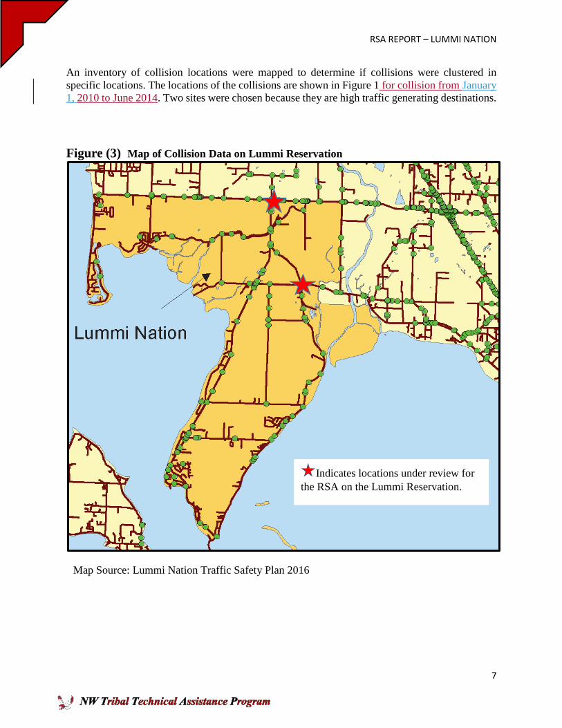
An inventory of collision locations were mapped to determine if collisions were clustered in
specific locations. The locations of the collisions are shown in Figure 1 for collision from January
1, 2010 to June 2014. Two sites were chosen because they are high traffic generating destinations.
Figure (3) Map of Collision Data on Lummi Reservation
Indicates locations under review for
the RSA on the Lummi Reservation.
Map Source: Lummi Nation Traffic Safety Plan 2016
RSA REPORT – LUMMI NATION
8
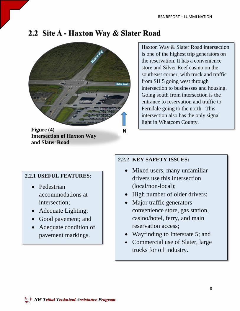
2.2.1 USEFUL FEATURES:
Pedestrian
accommodations at
intersection;
Adequate Lighting;
Good pavement; and
Adequate condition of
pavement markings.
2.2.2 KEY SAFETY ISSUES:
Mixed users, many unfamiliar
drivers use this intersection
(local/non-local);
High number of older drivers;
Major traffic generators
convenience store, gas station,
casino/hotel, ferry, and main
reservation access;
Wayfinding to Interstate 5; and
Commercial use of Slater, large
trucks for oil industry.
2.2 Site A - Haxton Way & Slater Road
Haxton Way & Slater Road intersection
is one of the highest trip generators on
the reservation. It has a convenience
store and Silver Reef casino on the
southeast corner, with truck and traffic
from SH 5 going west through
intersection to businesses and housing.
Going south from intersection is the
entrance to reservation and traffic to
Ferndale going to the north. This
intersection also has the only signal
light in Whatcom County.
Figure (4)
Intersection of Haxton Way
and Slater Road
N
RSA REPORT – LUMMI NATION
9
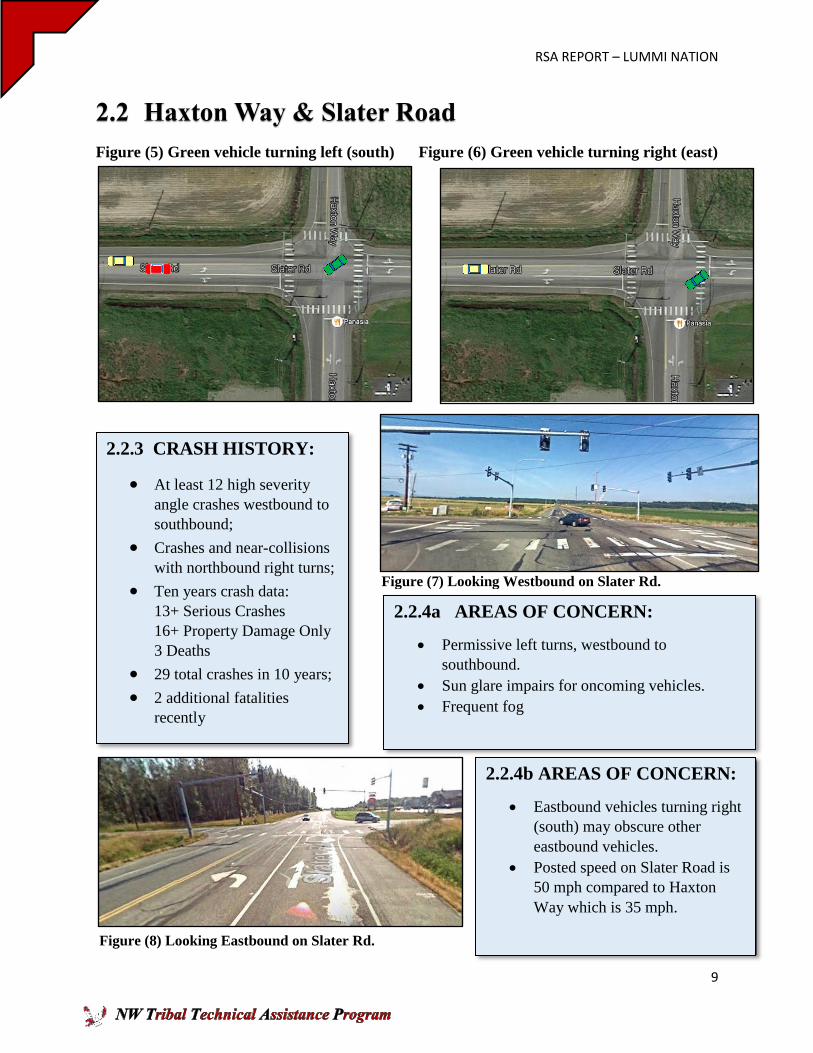
2.2.3 CRASH HISTORY:
At least 12 high severity
angle crashes westbound to
southbound;
Crashes and near-collisions
with northbound right turns;
Ten years crash data: 13+ Serious Crashes
16+ Property Damage Only
3 Deaths
29 total crashes in 10 years;
2 additional fatalities
recently
2.2 Haxton Way & Slater Road
Figure (5) Green vehicle turning left (south) Figure (6) Green vehicle turning right (east)
2.2.4a AREAS OF CONCERN:
Permissive left turns, westbound to
southbound.
Sun glare impairs for oncoming vehicles.
Frequent fog
2.2.4b AREAS OF CONCERN:
Eastbound vehicles turning right
(south) may obscure other
eastbound vehicles.
Posted speed on Slater Road is
50 mph compared to Haxton
Way which is 35 mph.
Figure (7) Looking Westbound on Slater Rd.
Figure (8) Looking Eastbound on Slater Rd.
RSA REPORT – LUMMI NATION
10
2.2 Haxton Way & Slater Road
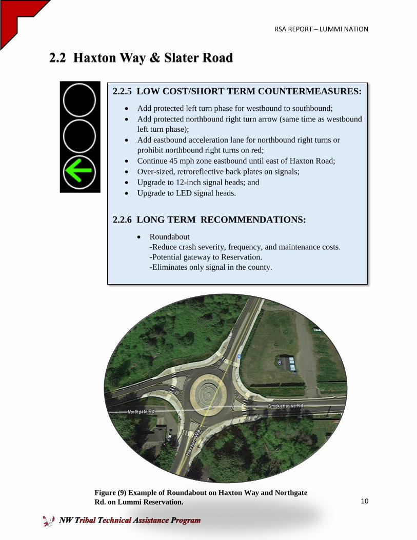
2.2.5 LOW COST/SHORT TERM COUNTERMEASURES:
Add protected left turn phase for westbound to southbound;
Add protected northbound right turn arrow (same time as westbound
left turn phase);
Add eastbound acceleration lane for northbound right turns or
prohibit northbound right turns on red;
Continue 45 mph zone eastbound until east of Haxton Road;
Over-sized, retroreflective back plates on signals;
Upgrade to 12-inch signal heads; and
Upgrade to LED signal heads.
2.2.6 LONG TERM RECOMMENDATIONS:
Roundabout
-Reduce crash severity, frequency, and maintenance costs.
-Potential gateway to Reservation.
-Eliminates only signal in the county.
Figure (9) Example of Roundabout on Haxton Way and Northgate
Rd. on Lummi Reservation.
RSA REPORT – LUMMI NATION
11
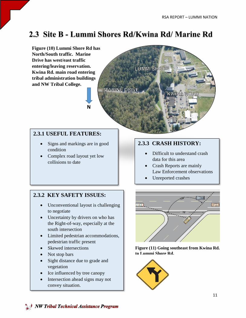
2.3 Site B - Lummi Shores Rd/Kwina Rd/ Marine Rd
N
2.3.1 USEFUL FEATURES:
Signs and markings are in good
condition
Complex road layout yet low
collisions to date
2.3.3 CRASH HISTORY:
Difficult to understand crash
data for this area
Crash Reports are mainly
Law Enforcement observations
Unreported crashes
2.3.2 KEY SAFETY ISSUES:
Unconventional layout is challenging
to negotiate
Uncertainty by drivers on who has
the Right-of-way, especially at the
south intersection
Limited pedestrian accommodations,
pedestrian traffic present
Skewed intersections
Not stop bars
Sight distance due to grade and
vegetation
Ice influenced by tree canopy
Intersection ahead signs may not
convey situation.
Figure (10) Lummi Shore Rd has
North/South traffic. Marine
Drive has west/east traffic
entering/leaving reservation.
Kwina Rd. main road entering
tribal administration buildings
and NW Tribal College.
Figure (11) Going southeast from Kwina Rd.
to Lummi Shore Rd.

RSA REPORT – LUMMI NATION
12
2.3 Lummi Shores Rd/Kwina Rd/ Marine Rd
Figure (13) View going west on
Marine Drive toward Y-shaped
intersection leading to Lummi Shore
Rd in both directions. In order to get
on Kwina Rd. vehicles would have to
make a sharp 45 degree turn onto
Lummi Shore Rd. Sight distance
obstructed to oncoming traffic.
Figure (14) Viewing southwest
coming off Marine Drive taking left
at fork going on to Lummi Shore Rd.
Many unnecessary signs in the
middle of divided road, distracting
to drivers.
2.3.4 AREAS OF CONCERN:
Reduced sight distance due to
horizontal and vertical
alignment.
No lighting on 3 of the 4
intersections. Difficult to detect
alignment at night.
Signs on the road not related to
traffic.
Figure (12) Marine Drive going west taking left
at fork approaching Lummi Shore Rd. to turn
south. Limited sight distance to oncoming
traffic.
RSA REPORT – LUMMI NATION
13
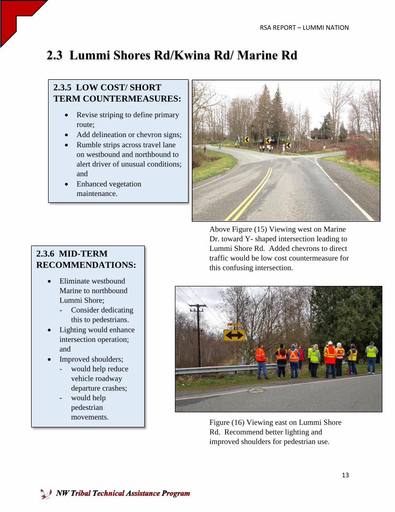
2.3 Lummi Shores Rd/Kwina Rd/ Marine Rd
Above Figure (15) Viewing west on Marine
Dr. toward Y- shaped intersection leading to
Lummi Shore Rd. Added chevrons to direct
traffic would be low cost countermeasure for
this confusing intersection.
Figure (16) Viewing east on Lummi Shore
Rd. Recommend better lighting and
improved shoulders for pedestrian use.
2.3.5 LOW COST/ SHORT
TERM COUNTERMEASURES:
Revise striping to define primary
route;
Add delineation or chevron signs;
Rumble strips across travel lane
on westbound and northbound to
alert driver of unusual conditions;
and
Enhanced vegetation
maintenance.
2.3.6 MID-TERM
RECOMMENDATIONS:
Eliminate westbound
Marine to northbound
Lummi Shore;
- Consider dedicating
this to pedestrians.
Lighting would enhance
intersection operation;
and
Improved shoulders;
- would help reduce
vehicle roadway
departure crashes;
- would help
pedestrian
movements.
RSA REPORT – LUMMI NATION
14
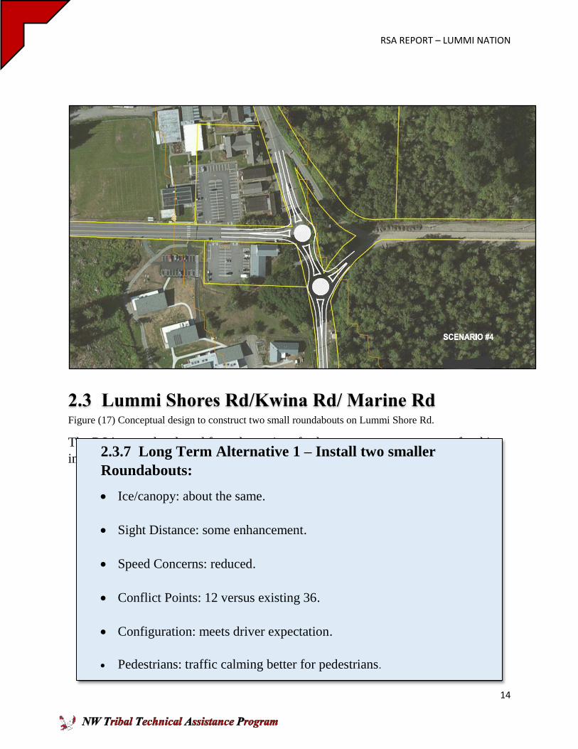
2.3 Lummi Shores Rd/Kwina Rd/ Marine Rd Figure (17) Conceptual design to construct two small roundabouts on Lummi Shore Rd.
The RSA team developed four alternatives for long term countermeasure for this
intersection.
2.3.7 Long Term Alternative 1 – Install two smaller
Roundabouts:
Ice/canopy: about the same.
Sight Distance: some enhancement.
Speed Concerns: reduced.
Conflict Points: 12 versus existing 36.
Configuration: meets driver expectation.
Pedestrians: traffic calming better for pedestrians.
RSA REPORT – LUMMI NATION
15
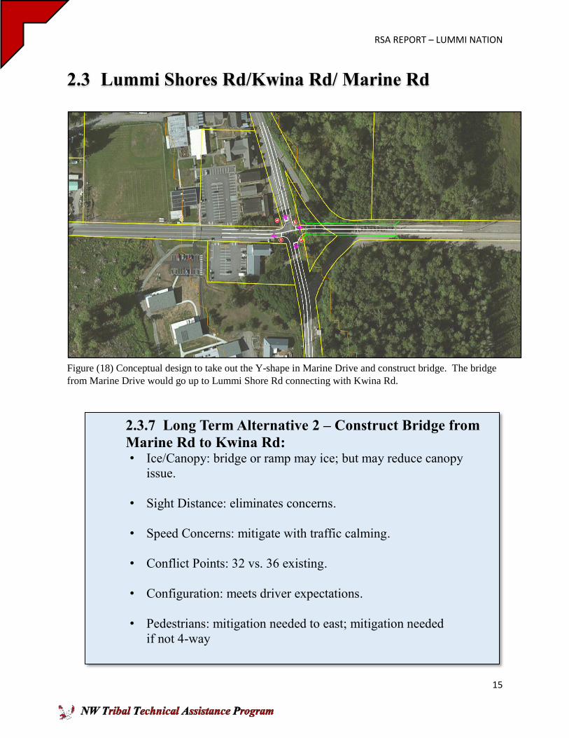
2.3 Lummi Shores Rd/Kwina Rd/ Marine Rd
Figure (18) Conceptual design to take out the Y-shape in Marine Drive and construct bridge. The bridge
from Marine Drive would go up to Lummi Shore Rd connecting with Kwina Rd.
2.3.7 Long Term Alternative 2 – Construct Bridge from
Marine Rd to Kwina Rd: • Ice/Canopy: bridge or ramp may ice; but may reduce canopy
issue.
• Sight Distance: eliminates concerns.
• Speed Concerns: mitigate with traffic calming.
• Conflict Points: 32 vs. 36 existing.
• Configuration: meets driver expectations.
• Pedestrians: mitigation needed to east; mitigation needed
if not 4-way
RSA REPORT – LUMMI NATION
16
2.3. Lummi Shores Rd/Kwina Rd/ Marine Rd
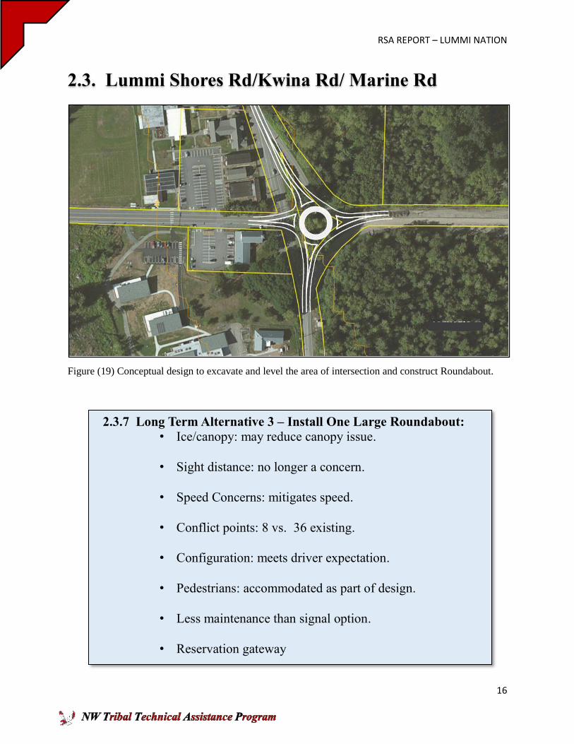
Figure (19) Conceptual design to excavate and level the area of intersection and construct Roundabout.
2.3.7 Long Term Alternative 3 – Install One Large Roundabout:
• Ice/canopy: may reduce canopy issue.
• Sight distance: no longer a concern.
• Speed Concerns: mitigates speed.
• Conflict points: 8 vs. 36 existing.
• Configuration: meets driver expectation.
• Pedestrians: accommodated as part of design.
• Less maintenance than signal option.
• Reservation gateway
RSA REPORT – LUMMI NATION
17
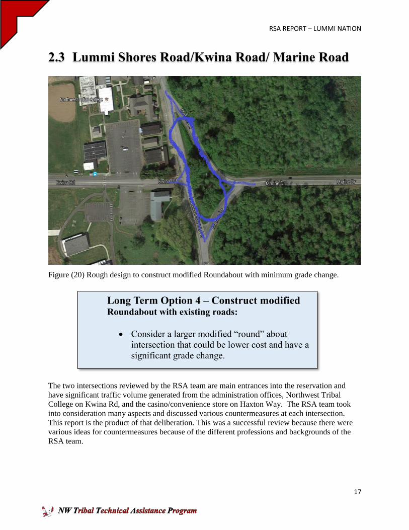
2.3 Lummi Shores Road/Kwina Road/ Marine Road
Figure (20) Rough design to construct modified Roundabout with minimum grade change.
The two intersections reviewed by the RSA team are main entrances into the reservation and
have significant traffic volume generated from the administration offices, Northwest Tribal
College on Kwina Rd, and the casino/convenience store on Haxton Way. The RSA team took
into consideration many aspects and discussed various countermeasures at each intersection.
This report is the product of that deliberation. This was a successful review because there were
various ideas for countermeasures because of the different professions and backgrounds of the
RSA team.
Long Term Option 4 – Construct modified Roundabout with existing roads:
Consider a larger modified “round” about
intersection that could be lower cost and have a
significant grade change.
RSA REPORT – LUMMI NATION
18
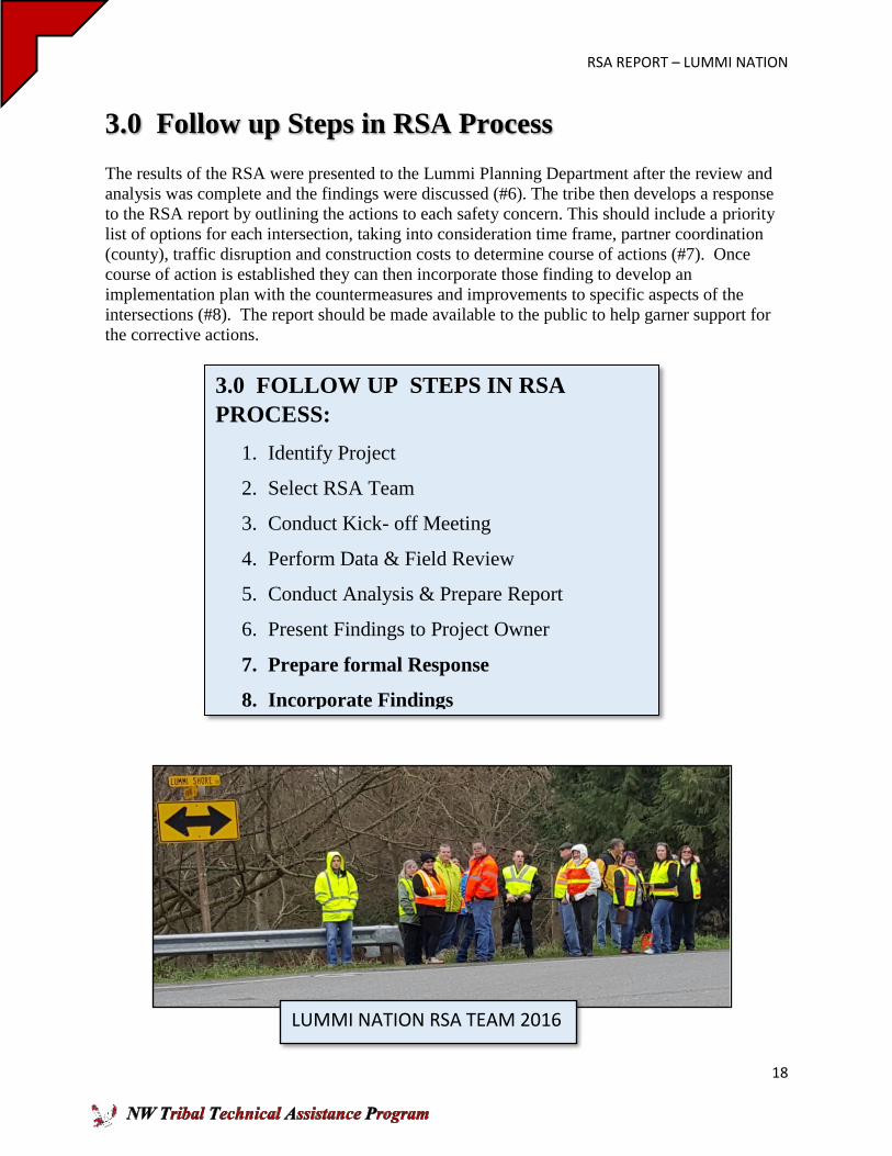
3.0 Follow up Steps in RSA Process
The results of the RSA were presented to the Lummi Planning Department after the review and
analysis was complete and the findings were discussed (#6). The tribe then develops a response
to the RSA report by outlining the actions to each safety concern. This should include a priority
list of options for each intersection, taking into consideration time frame, partner coordination
(county), traffic disruption and construction costs to determine course of actions (#7). Once
course of action is established they can then incorporate those finding to develop an
implementation plan with the countermeasures and improvements to specific aspects of the
intersections (#8). The report should be made available to the public to help garner support for
the corrective actions.
3.0 FOLLOW UP STEPS IN RSA
PROCESS:
1. Identify Project
2. Select RSA Team
3. Conduct Kick- off Meeting
4. Perform Data & Field Review
5. Conduct Analysis & Prepare Report
6. Present Findings to Project Owner
7. Prepare formal Response
8. Incorporate Findings
LUMMI NATION RSA TEAM 2016