Los Angeles World Airports Civil3D... · Los Angeles World Airports Capital Programming, Planning...
30
Los Angeles World Airports Capital Programming, Planning and Engineering Group Autodesk Civil 3D Standards and Practices FINAL Utility Infrastructure Project Los Angeles International Airport (LAX) Project Manager: Teresa Sarullo. P. E. BY: HNTB DATE: July 08, 2015
Transcript of Los Angeles World Airports Civil3D... · Los Angeles World Airports Capital Programming, Planning...

Los Angeles World Airports Capital Programming, Planning and Engineering Group
Autodesk Civil 3D Standards and Practices
FINAL Utility Infrastructure Project
Los Angeles International Airport (LAX)
Project Manager: Teresa Sarullo. P. E.
BY: HNTB
DATE: July 08, 2015


Autodesk Civil 3D Standards for LAWA Projects

Autodesk Civil 3D standards for LAWA Projects
Document History
Revision letter Release date Major changes Approved by
Civil3D_Standards_2015.docx revision letter: A revision date: July 2015 HNTB Corporation 2015 Status: Final Page 1 of 26
Autodesk Civil 3D standards for LAWA Projects
Table of Contents
About this book ............................................................................................................................................. 3
Relation to existing standards................................................................................................................... 3
Who should read this book ....................................................................................................................... 3
How this book is organized ....................................................................................................................... 4
Related documents ................................................................................................................................... 4
Abbreviations ............................................................................................................................................ 5
Introduction .................................................................................................................................................. 6
Benefits of CAD Standards ........................................................................................................................ 6
General principles ..................................................................................................................................... 6
Templates.................................................................................................................................................. 6
Standards in use at LAWA ............................................................................................................................. 7
LAWA standards ........................................................................................................................................ 7
National and International standards ....................................................................................................... 8
Compliance ............................................................................................................................................... 8
Request of Variance .................................................................................................................................. 8
Autodesk Civil 3D .......................................................................................................................................... 9
General Settings ........................................................................................................................................ 9
Civil 3D labels .......................................................................................................................................... 12
Civil 3D Parts Lists ................................................................................................................................... 13
Civil 3D Pipe Styles .................................................................................................................................. 15
GIS Attribute Data ....................................................................................................................................... 20
Autodesk Civil 3D Property Sets .............................................................................................................. 21
Sample Civil 3D views .................................................................................................................................. 24
Pipe Networks in Plan View .................................................................................................................... 24
Pipe Networks in 3D View ....................................................................................................................... 25
Finished Civil 3D Model ........................................................................................................................... 26
Civil3D_Standards_2015.docx revision letter: A revision date: July 2015 HNTB Corporation 2015 Status: Final Page 2 of 26

Autodesk Civil 3D standards for LAWA Projects
About this book
The standards described in this document are provided to help LAWA staff, consultants and project partners prepare CAD files for use in LAWA projects using Autodesk Civil 3D software. By using these standards, LAWA will achieve a standardized approach to spatial data management and related record document(s) that will bring many benefits to both the organization and its staff. These benefits include, but are not limited to:
• consistent and more reliable data that will lead to more informed decision making • closer integration with other LAWA information systems and LAWA spatial data users • portability of staff skills • greater interoperability with organizations outside of LAWA
Relation to existing standards These LAWA-specific Civil 3D standards are generally derived from LAWA CAD Standards and industry best practices when using the software.
Who should read this book This book is intended for all LAWA project partners, and especially for members of their staff who prepare CAD drawings using Autodesk Civil 3D software for use within a project. It is provided to promote and support effective implementation of CAD drawing standards within the airport, for the full project life-cycle.
Civil3D_Standards_2015.docx revision letter: A revision date: July 2015 HNTB Corporation 2015 Status: Final Page 3 of 26

Autodesk Civil 3D standards for LAWA Projects
How this book is organized After the introduction, this book contains the following chapters and appendixes:
Civil 3D General
Settings and general information regarding using Autodesk Civil 3D.
Civil 3D Pipe Networks
Descriptions of custom LAWA Pipe networks
GIS Data Workflows
Processes for dealing with LAWA required Object Data in Civil 3D
Related documents BIM, GIS, Survey, Metadata and EDI standards along with other documentation related to these standards are available on the LAWA website on the LAWA Standard Documents and Guidelines page: http://www.lawa.org/welcome_LAWA.aspx?id=542
Civil3D_Standards_2015.docx revision letter: A revision date: July 2015 HNTB Corporation 2015 Status: Final Page 4 of 26

Autodesk Civil 3D standards for LAWA Projects
Abbreviations AEGIS - Airport Enterprise Geographical Information System
ANSI - American National Standards Institute
BIM - Building Information Modeling
CAD - Computer Aided Design and Drafting
CPPE - Capital Planning, Programming and Engineering
CSDGM - Content Standard for Digital Geospatial Metadata
DDMS - Document & Drawing Management System
EDI - Electronic Data Interchange
FAA - Federal Aviation Administration
FGDC - The Federal Geographic Data Committee
GIS - Geographic Information System
GISSSD - GIS Support Services Division
IMTG - Information Management Technology Group
ISO - International Organization for Standardization
LAWA - Los Angeles World Airports
LAX - Los Angeles International Airport
ONT - Ontario Airport
PMD - Palmdale Airport
SDSFIE - Spatial Data Standards for Facilities, Infrastructure, and Environment
VNY - Van Nuys Airport
Civil3D_Standards_2015.docx revision letter: A revision date: July 2015 HNTB Corporation 2015 Status: Final Page 5 of 26

Autodesk Civil 3D standards for LAWA Projects
Introduction
This document establishes Standards and Procedures for Autodesk Civil3D submittals to Los Angeles World Airports (LAWA). These processes are necessary for efficient Electronic Data Exchange between the airport and consultants and to ensure the data received by LAWA is compliant with internal data standards
Benefits of CAD Standards Drawing up and implementing detailed standards for CAD files standards is intended to ensure a smooth flow of information at every stage of the project. Consistent, comparable files bring benefits that include the following:
• project partners can share information confidently and easily • common format and comparable detail references are used for all projects within LAWA • information is presented in the same place in each set of drawing files • non-compliance and other errors can be quickly detected, reducing the need for change
requests • data can easily be translated between languages and file-formats; document storage and
retrieval can be automated
General principles • except for some specialized schematics, the software used to produce CAD drawings is
AutoCAD (a recent version) • the unit of measurement used for CAD architectural drawings is the inch • the unit of measurement used for CAD civil drawings is the U.S. foot • project codes are defined by LAWA on a project per project basis • all civil drawings must be created in NAD 83 California State Planes, Zone V, US Foot
coordinate system • all civil drawings will identify the survey epoch used, for example NSRS 2007, CORS 96, etc.. • all architectural drawings must use positive values for coordinates • all spatial data must be created in “Model Space” • all graphical elements must be in “Paper Space”
Templates Project partners and subcontractors who need to implement the CAD standards for LAWA projects can download templates to provide a working environment based on the LAWA CAD Standards. Each template (.dwt file) defines the layers for a specific discipline. Sample title blocks can also be downloaded.
Civil3D_Standards_2015.docx revision letter: A revision date: July 2015 HNTB Corporation 2015 Status: Final Page 6 of 26

Autodesk Civil 3D standards for LAWA Projects
Standards in use at LAWA
LAWA standards This section provides an overview of LAWA specific standards, plus related federal, local, and national standards. LAWA standards have been created to improve productivity and reliable information exchange through the full life-cycle of geospatial data, CAD and BIM files along with related documents.
LAWA Metadata Standards
Metadata is structured information that describes, explains, locates, or otherwise makes it easier to retrieve, use, or manage an information resource. Metadata is often called data about data or information about information.
LAWA GIS Standards
The LAWA GIS standards are directly based on the ANSI Spatial Data Standard for Facilities Infrastructure and Environment (SDSFIE), Release 2.60, extended in certain areas to handle specific information relevant to LAWA. GIS Standards for LAWA Projects presents the most important aspects of SDSFIE as it applies to LAWA.
LAWA Survey Standards
The LAWA Survey and Remote Sensing Standards are based on requirements laid out in Airport Circulars published by the FAA, adapted where necessary to suit LAWA-specific requirements.
LAWA BIM Standards
These guidelines focus primarily on adaptation of standards for practical and efficient application of BIM, particularly at the handover (Record - As-Built) stage of a project. Based on USACE_CAD-BIM_Technology Center: version 1.1 and National BIM standard (United States): version2
LAWA EDI (Electronic Data Interchange) Standards
This Standard provides a framework for all data requests and all hard copy or electronic data submittals to or from LAWA, thus ensuring a streamlined data exchange process
Civil3D_Standards_2015.docx revision letter: A revision date: July 2015 HNTB Corporation 2015 Status: Final Page 7 of 26

Autodesk Civil 3D standards for LAWA Projects
National and International standards
AIA CAD Layer Guidelines and the National CAD Standards (NCS)
The LAWA CAD standards are based largely on the AIA CAD Layer Guidelines and the National CAD Standards (NCS), adapted where necessary to suit LAWA-specific requirements.
SDSFIE 2.6
The overall structure of LAWA current geospatial repository is based on SDSFIE 2.6. SDSFIE organizes real world features such as runways, roads and water pipes into a hierarchical structure.
Compliance Having timely up to date, accurate, fully compliant data available to the LAWA community forms an integral part of planning within any project. The aim of these standards is to ensure a smooth data transfer of information into the LAWA geospatial data base and efficient data maintenance through the complete data lifecycle. Accordingly, the terms and conditions of a LAWA contract require compliance with these standards.
Failure to comply with these standards may result in organizations being back-charged for any financial costs incurred by LAWA for rectifying inconsistencies and errors
The individual or organization submitting the files is also responsible for ensuring that all links between non-graphic data and graphic data, and all relationships between database tables, shall be preserved or automatically reconstructed when data is transferred to the LAWA GIS environment.
Request of Variance Compliance with the LAWA standards and data deliverables demands are the cornerstone of achieving trustworthy and relevant data.
Suggestions for improvements or extensions to these standards and demands are encouraged, to meet unforeseen requirements and as a way to improve effectiveness and clarify any ambiguities; any such deviation must be approved by LAWA, in advance and in writing. . Requests need to be submitted on the “Request for variance” form, this form along with other documentation related to these standards are available on the LAWA website. http://www.lawa.org/welcome_LAWA.aspx?id=542
Civil3D_Standards_2015.docx revision letter: A revision date: July 2015 HNTB Corporation 2015 Status: Final Page 8 of 26

Autodesk Civil 3D standards for LAWA Projects
Autodesk Civil 3D
General Settings Current version
The current LAWA approved version of Autodesk Civil 3d is 2014. Use of a year release other than the currently approved version will require written approval from LAWA xxxx Department.
File Management
When delivering Civil 3D content to LAWA, use the built-in eTransmit function. This packages the document with all dependencies. From the Application menu (the button on the top left with C3D on it), select Publish, then eTransmit.
Civil3D_Standards_2015.docx revision letter: A revision date: July 2015 HNTB Corporation 2015 Status: Final Page 9 of 26

Autodesk Civil 3D standards for LAWA Projects
Object Data / Attribute Data
Layers
The LAWA Civil 3D template (.dwt) is prepopulated with LAWA compliant layers. Individual Pipe styles are set to use the compliant layer standards. If additional layers are required, please refer to the LAWA CAD Standards document for information regarding LAWA CAD layer standards.
Coordinate Systems
The LAWA Civil 3D template (.dwt) is preset with the current LAWA approved Coordinate System (CA83-VF). Modification of the Coordinate System should only be done at the direction of LAWA
To set the Coordinate system in Civil 3D, first switch the Workspace to Planning and Analysis. Then from the Map Setup tab on the Ribbon, select Assign in the Coordinate System panel.
Select CA83-VF from the list and Assign at the bottom of the dialog box
Civil3D_Standards_2015.docx revision letter: A revision date: July 2015 HNTB Corporation 2015 Status: Final Page 10 of 26

Autodesk Civil 3D standards for LAWA Projects
Civil3D_Standards_2015.docx revision letter: A revision date: July 2015 HNTB Corporation 2015 Status: Final Page 11 of 26

Autodesk Civil 3D standards for LAWA Projects
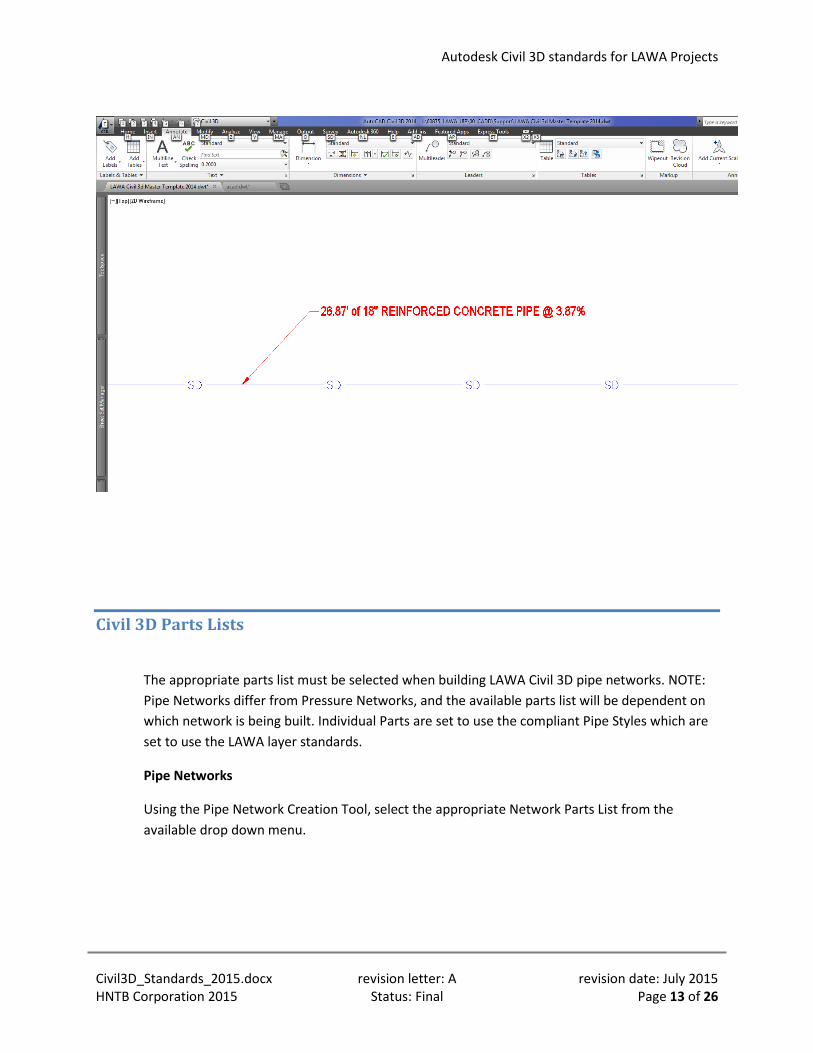
Civil 3D labels
Lables can be added to Civil 3D Pipes and Structres using data such as Pipe Material, Pipe, Length, and Slope. Label Styles can be created in the Settings Tab of the Toolspace Panel. Label Styles shall be created using the appropriate LAWA standards, including font and layer information.
Once a Label Style has been created, use the Add Labels button (located on the Annotate Tab of the Civil 3D ribbon) to bring up the Add Labels Dialog Box. Select the desired Label Style, and then follow the prompts to attach a label to the correct Civil 3D element. Once a label is attached, it should look similar to the following:
Civil3D_Standards_2015.docx revision letter: A revision date: July 2015 HNTB Corporation 2015 Status: Final Page 12 of 26
Autodesk Civil 3D standards for LAWA Projects
Civil 3D Parts Lists
The appropriate parts list must be selected when building LAWA Civil 3D pipe networks. NOTE: Pipe Networks differ from Pressure Networks, and the available parts list will be dependent on which network is being built. Individual Parts are set to use the compliant Pipe Styles which are set to use the LAWA layer standards.
Pipe Networks
Using the Pipe Network Creation Tool, select the appropriate Network Parts List from the available drop down menu.
Civil3D_Standards_2015.docx revision letter: A revision date: July 2015 HNTB Corporation 2015 Status: Final Page 13 of 26
Autodesk Civil 3D standards for LAWA Projects
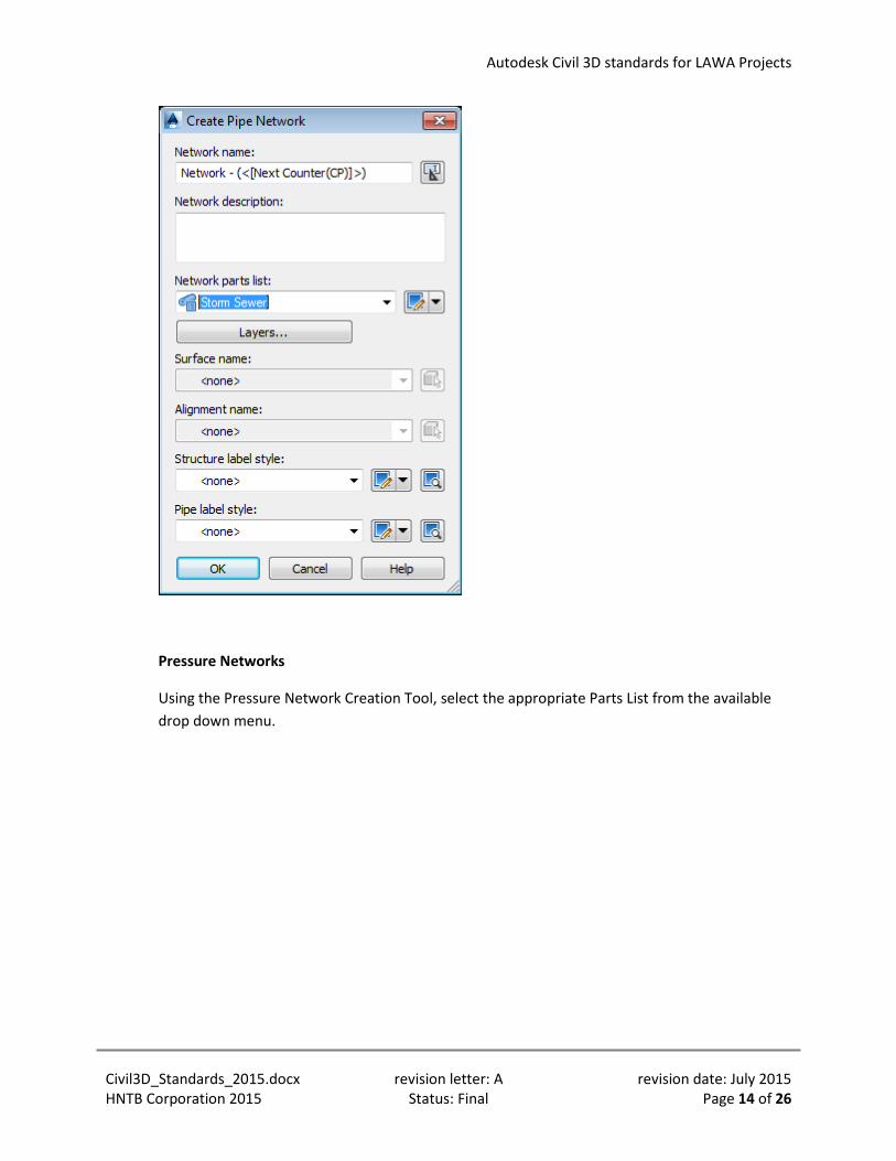
Pressure Networks
Using the Pressure Network Creation Tool, select the appropriate Parts List from the available drop down menu.
Civil3D_Standards_2015.docx revision letter: A revision date: July 2015 HNTB Corporation 2015 Status: Final Page 14 of 26

Autodesk Civil 3D standards for LAWA Projects
Civil 3D Pipe Styles
New Pipe styles are created using the Pipe Style Editor dialog box. This can be accessed via the Settings Tab on a drawing’s Toolspace.
Civil3D_Standards_2015.docx revision letter: A revision date: July 2015 HNTB Corporation 2015 Status: Final Page 15 of 26

Autodesk Civil 3D standards for LAWA Projects
During the style creation process, the new Pipe Style should be properly assigned to LAWA’s standard layers.
Civil3D_Standards_2015.docx revision letter: A revision date: July 2015 HNTB Corporation 2015 Status: Final Page 16 of 26

Autodesk Civil 3D standards for LAWA Projects
The Civil 3D Pipe Styles are automatically selected based on the Parts List being used. However, if the Pipe Style needs to be assigned after a pipe has been created; the following styles can be assigned for the appropriate system using the drop down menu from the Pipe Properties.
Storm Water & Drainage
Civil3D_Standards_2015.docx revision letter: A revision date: July 2015 HNTB Corporation 2015 Status: Final Page 17 of 26

Autodesk Civil 3D standards for LAWA Projects
Sanitary Sewer
Domestic Water
Reclaimed Water
Civil3D_Standards_2015.docx revision letter: A revision date: July 2015 HNTB Corporation 2015 Status: Final Page 18 of 26

Autodesk Civil 3D standards for LAWA Projects
Electrical
Communications
Natural Gas
Civil3D_Standards_2015.docx revision letter: A revision date: July 2015 HNTB Corporation 2015 Status: Final Page 19 of 26

Autodesk Civil 3D standards for LAWA Projects
Jet Fuel
Fire Water
GIS Attribute Data
LAWA records specific attribute data for utilities in the Airport Enterprise GIS database (AEGIS). Property Set Definitions are used in Civil 3D in order to collect the required data.
For additional information, and specific attributes required for your project, see the LAWA GIS Standards and contact the LAWA GIS department.
Civil3D_Standards_2015.docx revision letter: A revision date: July 2015 HNTB Corporation 2015 Status: Final Page 20 of 26

Autodesk Civil 3D standards for LAWA Projects
Autodesk Civil 3D Property Sets
To access Property Set Definitions in Civil 3D, type AECSTYLEMANAGER at the command line. Expand Documentation Objects and Property Set Definitions to reveal the LAWA_AEGIS Property Set. The LAWA_AEGIS Property Set can be added to lines, Polylines, Pipe, and Pressure Pipes as it is in the template. Additional categories can be added via the Applies to tab of the Style Manager. A sample set of metadata attribute fields have been prepopulated in the Property Set. You must confirm the required attributes fields and acceptable values with LAWA prior to deliverable submission.
Use the tools on the right to create or delete Property Set Definitions based on the specific project requirements.
To add Property Set Definitions to objects in Civil 3D, first select the object or objects, then select the Extended Data tab of the properties palette and the Add Property Sets button at the bottom.
Civil3D_Standards_2015.docx revision letter: A revision date: July 2015 HNTB Corporation 2015 Status: Final Page 21 of 26

Autodesk Civil 3D standards for LAWA Projects
Select the LAWA_AEGIS Property Set to add the property Set definitions to the selected object(s). Once the Property Sets is added, the Property Set Definitions are visible on the Extended Data tab of the Properties Palette. Values can be manually input in this dialog. Acceptable input values must be confirmed with LAWA prior to deliverable submission.
Civil3D_Standards_2015.docx revision letter: A revision date: July 2015 HNTB Corporation 2015 Status: Final Page 22 of 26

Autodesk Civil 3D standards for LAWA Projects
Civil3D_Standards_2015.docx revision letter: A revision date: July 2015 HNTB Corporation 2015 Status: Final Page 23 of 26

Autodesk Civil 3D standards for LAWA Projects
Sample Civil 3D views
The following are examples of how Pipe Networks appear in Civil 3D both Plan and 3D views.
NOTE: Civil 3D Pipe Network Styles, and any line types associated with those styles are not compatible with LAWA’s GIS Database (AEGIS).
Pipe Networks in Plan View
Civil3D_Standards_2015.docx revision letter: A revision date: July 2015 HNTB Corporation 2015 Status: Final Page 24 of 26

Autodesk Civil 3D standards for LAWA Projects
Pipe Networks in 3D View
Civil3D_Standards_2015.docx revision letter: A revision date: July 2015 HNTB Corporation 2015 Status: Final Page 25 of 26

Autodesk Civil 3D standards for LAWA Projects
Finished Civil 3D Model
Civil3D_Standards_2015.docx revision letter: A revision date: July 2015 HNTB Corporation 2015 Status: Final Page 26 of 26