Local Village Centres - Waverley · PDF fileprepared for Waverley Council. This Public Domain...
72
Local Village Centres Public Domain Improvement Plan
Transcript of Local Village Centres - Waverley · PDF fileprepared for Waverley Council. This Public Domain...

Local Village CentresPublic Domain Improvement Plan

Public Domain Improvement Plan 2006 - Local Village Centres
3Index
TABLE OF CONTENTS
1.0 INTRODUCTION1.1 Background 1.2 Study Area1.3 Purpose of the Report1.4 Structure1.5 Related Documents
2.0 DESIGN PRINCIPLES2.1 The Public Domain2.2 Landform and Views2.3 Identity2.4 Access and Transport2.5 Liveability2.6 Urban Elements2.7 Public Art2.8 Water Sensitive Urban Design2.9 Trees2.10 Streets and Lanes2.11 Parks and Reserves
3.0 PUBLIC DOMAIN PROJECTS3.1 Bronte Beach Neighbourhood Centre3.2 Bronte Macpherson St Neighbourhood Centre3.3 Charing Cross Small Village3.4 Murray Street Neighbourhood Centre3.5 Bondi Road Village3.6 Old South Head Road Neighbourhood Centres (at Murriverie Rd., Blair St., Flood St.)3.7 Hall Street Town Centre3.8 Glenayr Avenue Neighbourhood Centre3.9 North Bondi Neighbourhood Centre3.10 Murriverie Road Neighbourhood Centre3.11 Rose Bay Small Villages (North and South)3.12 Blake Street Neighbourhood Centre
444667
8889910111112121314
161822 283236
42485458626670

Public Domain Improvement Plan 2006 - Local Village Centres
Page No.F4 Introduction4
1.0 INTRODUCTION
1.1 BackgroundThis document has been prepared in conjunction with Part F5 Local Village Centres, Draft Waverley DCP 2006 (Amendment No.1), prepared for Waverley Council. This Public Domain Improvement Plan and Technical Manual provide a basis for coordinated implementation of public domain improvements for the streets and open spaces of the Local Village Centres.
1.2 Study AreaThe Public Domain Improvement Plan covers twelve commercial centres in the Waverley Local Government Area:
01 Bronte Beach;02 Bronte Macpherson Street;03 Charing Cross;04 Murray Street;05 Bondi Road;06 Old South Head Road Neighbourhood Centres (at Murriverie Rd., Blair St., Flood St.);07 Hall Street;08 Glenayr Avenue;09 North Bondi;10 Murriverie Road;11 Rose Bay Small Villages (North and South); and12 Blake Street;
The commercial centres vary widely in size, activity and character. They have been classifi ed according to subregional planning types (NSW Metropolitan Strategy) adopted by Part F5. The hierarchy, illustrated in Figure 1, also forms the basis for a strategy for paving and urban elements, described in Section 2.5.

5
Public Domain Improvement Plan 2006_ Local Village Centres_ Draft
Introduction
11 Rose Bay Small Village Centres
Town Centre
Village + Small Village Centre
Neighbourhood Centre
10 Murriverie Rd
05 Bondi Rd
08 Glenayr Ave
12 Blake St
03 Charing Cross
02 Bronte Macpherson Street
01 Bronte Beach Centre
04 Murray St
07 Hall St
09 North Bondi
09 North Bondi Wairoa Ave
Flood St.
Blair St.
Murriverie Rd. 06 Old South Head Rd Neighbourhood Centres
north
south

Public Domain Improvement Plan 2006 - Local Village Centres
Page No.F4 Introduction6
1.3 Purpose of the ReportThis Public Domain Improvement Plan and accompanying Technical Manual are intended to guide and coordinate the design and construction of improvements to the public domain in the village centres. The Public Domain Improvement Plan identifi es opportunities for enhancement of all aspects of the public domain, and where possible identifi es the potential for provision of more pedestrian space. The Technical Manual provides a coordinated approach to design, construction and maintenance of the public domain.
The Public Domain Improvement Plan and Technical Manual are intended for use by:
• The general public in understanding the issues involved in protecting existing values inherent to each site, and in
developing strategies for upgrading the area;• Developers, designers, and consultants preparing proposals
affecting the public domain and its components;• Consent authorities assessing and approving the proposed
development; and • Council offi cers, in preparation of developed designs for each
centre, or for adjoining areas.
The Technical Manual will be a controlled document that will be updated in line with changes in maintenance requirements and construction technology, and also as designs for each area are developed.
1.4 StructureThis Public Domain Improvements Plan (PDIP) is a guideline document that proposes overall principles and strategies for the provision, structure, function and identity of the public domain within, and in some cases, immediately adjoining each village centre. The PDIP has been prepared in conjunction with Part F5 - Local Village Centres of Waverley DCP 2006 (Amendment No.1), and has been informed by community consultation, input from specialist consultants, and from Council offi cers. The PDIP is constructed to move from the broad to the particular, in order to cover all aspects affecting public domain design.
The PDIP contains:Section 2 - Principles to set a framework for planning and design of all aspects of the public domain.
Section 3 – Public Domain Projects, gives a broad strategy for each centre, and guidelines for specifi c projects identifi ed in the strategy. The guidelines are presented as 1:500 scale concept drawings.
The PDIP is intended as a basis for the development of designs for the public domain; the concepts illustrate a set of principles rather than a resolved design.

Public Domain Improvement Plan 2006 - Local Village Centres
7Introduction
The Public Domain Technical Manual comprises: • Section 3 – design and layout principles for streets. • Section 4 – the main part of the document contains a series
of standard details and performance criteria to be used as a guide-line for design and construction for streets and small public spaces within the study areas. This includes a standard range of street furniture, lighting, paving and surface treatments to ensure continuity of maintenance practices, and to unify the public domain.
1.5 Related DocumentsThis document has been prepared in conjunction with Part F5 - Local Village Centres of the Draft Waverley DCP 2006 (Amendment No.1). Readers of this PDIP and the Technical Manual should refer to the Part F5 - Local Village Centres for details of building development and how they are encouraged to interact with the public domain.
Readers should also refer to the following documents for development of designs for upgrading the public domain:
Tree Management Plan;Draft Waverley Heritage Assessment;Green Links Project (background study);Small Parks Plan of Management;Part E3 - Footpath Seating for Restaurants of WDCP 2006;Arts Plus Plan - Draft September 2006;Looking Good Strategy; andPart J1 - Access for People with Disabilities of WDCP 2006,

Public Domain Improvement Plan 2006 - Local Village Centres
Page No.F4 Design Principles8
2.0 DESIGN PRINCIPLES
2.1 The Public DomainThe public domain is generally considered to be the land that is in public ownership and freely accessible to the public: the streets, parks and squares of the urban area. Within the village centres, the public domain is generally comprised of streets andsmall public spaces, with some centres having small local parksand green spaces adjacent. The public domain may also include the interface between public and private: – spaces where building setbacks form an extension to streets and open spaces. All these spaces have been considered together for the purposes of the PDIP.
It is essential that all elements of the public domain are considered together. Measures to control traffi c should be balanced with pedestrian comfort and convenience, the existing geometry of streets, and the desired future character of each centre. This PDIP aims to maximise amenity for all users of the public domain, and to upgrade the image of each centre while retaining and enhancing the characteristics that form the centre’s identity.
The principles set out in this section provide a design framework for the public domain of the village centres. These principles underpin the strategies and improvements outlined in Section 3.
2.2 Landform and ViewsLandform helps to shape the physical identity and spatial quality of the public domain. Each centre within the study area has a different setting; some centres on Old South Head Road sit high up in the landform of cliffs, sand dunes and valleys which are characteristic of Waverley and Woollahra LGAs. Others, such as Bronte Beach, sit low in the landscape with an immediate connection to the sea.
Design of the public domain should seek to enhance the patterns that respond to landform, and to retain or open upsignifi cant views. The desire for street tree planting, for example, should often be balanced against retaining a view to the sea or sky which may characterise a particular place. Layout, and placement of elements can contribute to character by orientation of places to a signifi cant view. Design should also work with the qualities of landform to provide appropriate pedestrian connections and ways through spaces.
Signifi cant views or landform characteristics particular to each centre have been identifi ed in the text and/or Potential diagram associated with each centre.

Public Domain Improvement Plan 2006 - Local Village Centres
9Design Principles
Principles:• Retain signifi cant views from streets to water and open sky;• Where possible locate small public spaces on sites with signifi cant views; and• Identify signifi cant views, and consider these in the selection and
placement of street trees and furniture.
2.3 IdentityEach centre has a particular identity related to physical setting, history, urban form, built form and landscape character, major activities and community cultural expression. The infl uence ofeach of these aspects on identity will vary between centres –the identity of the Charing Cross Village Centre, for instance, is defi ned to a greater degree by it’s built edge, whereas Bronte Beach is identifi ed by the setting and the view.
The type and quality of paving and street furniture potentially make a contribution to the character of each place, within the broader context of the sense of place defi ned by other signifi cant elements.
Principles:• Where appropriate, maintain the sense of the broader physical
setting through layout, views and landscape connections;• Reinforce the qualities of the environment though appropriate
paving and street furniture selection. Design should seek to complement, rather than compete with, the colours and forms of the physical setting;
• Recognise that a vibrant street life is an element of cultural life;• Recognise and highlight elements of history that contribute to
cultural identity; and• Enhance the quality of signifi cant buildings in the public and
private domains.
2.4 Access and TransportA fundamental principle of public domain design is to encourage walking as a form of transport. Streets must comfortably accommodate vehicular, cycle and pedestrian use, and reduce confl ict between these forms of access. The aim of plans, through design, should be to give priority to pedestrians in commercial centres, to maximise comfort and safety, and make a liveable, walkable place.
Use of public transport should be encouraged through ease ofaccess to public transport, and the provision of comfortable waiting areas.
Principles:• Rationalise the layout of vehicular circulation to minimum standards where possible, to provide opportunities to enhance
and extend pedestrian space;• Identify areas of pedestrian/vehicle confl ict and rectify where possible;

Public Domain Improvement Plan 2006 - Local Village Centres
Page No.F4 Design Principles10
Provide seating and shelter at bus waiting areas; and• Provide cycle facilities, including bike lock up loops, in the public
domain where possible.
Several areas of pedestrian/vehicle confl ict have been identifi ed in the improvement plan, and broad concepts for improvement proposed. These proposals should be followed up by detailed design resolution, and approval by Waverley Council’s Traffi c Committee.
For further information please refer to the Green Links Project Background Study, July 2006.
2.5 LiveabilityPromoting pedestrian amenity is central to design of the publicdomain. Encouraging pedestrian access reduces car depen-dency, promotes equal access and increases opportunities forsocial exchange and community life. Streets and public spacesshould be comfortable, safe and engaging places that encou-rage people to visit and to stay. There should be spaces that supplement commercial activity, where people can interact socially without the need to spend money. There should also be shelter, seating and visual delight.
Many of the Local Village Centres are small focal places for local residential communities. The public domain should serve their needs, through provision of social spaces, and by reinforcing community identity.
Pedestrian routes to and within centres should, where possible, be designed to be accessible to everyone, including people withmobility impairments. They should offer a continuous path oftravel where possible, or include areas without steps and steepgrades. Use the opportunity provided by public domain improve-ments to improve disability access.
Principles:• Provide access to streets, parks and public spaces for all users; • Use the opportunity provided by public domain improvements to
improve disability access;• Eliminate level changes, obstructions and confusing paving
patterns as much as possible;• Provide clear and generous links between high use areas, and
improve the relationship of streets to associated public spaces;• Create spaces for social interaction to supplement the street; • Improve pedestrian environments and encourage use through
pavement widening, street tree planting and upgrading of furniture and facilities; • Enhance safety and the perception of personal security, and
implement the recommendations of CPTED where applicable.Refer to the Local Village Centres Technical Manual for specifi c guidelines for designing for people with a disbility; and

Public Domain Improvement Plan 2006 - Local Village Centres
11Design Principles
• Provide community information notice pillars where appropriate.
2.6 Urban ElementsGood design in the public domain can reinforce site characte-ristics and contribute to the identity of the commercial centres. Street furniture, paving and lighting create the detail and quality in the public domain.
Furnishing in the public domain should respond to the scale, function and location of each centre. There should, however, be a limited range of elements across the Waverley LGA to promote a uniformity in maintenance practices. A limited palette of materials used in a variety of ways reinforces unity and allows for variation in detail where appropriate.
The centres within the study area are generally smaller, low key areas, with a degree of informality in each setting. The inclusion of complex paving patterns and furniture, polished surfaces and a high degree of variety would be inappropriate in these centres.
The Local Village Centres Technical Manual details the layout and type of paving and furniture. The Technical Manual proposes a hierarchy of paving and furniture treatments, based on the size and activity of each centre, and its contribution to the identity of locality. The proposed paving materials and hierarchy have been developed from a study carried out for the Bronte Centres in 2004 - ‘Bronte Commercial Centres Policy’ which is supplanted by the Local Village Centres project.
The hierarchy proposes a limited palette of elements used as follows:
Town Centres and Village CentresHigh quality paving and street furniture with a moderate level ofdetail, and paving in traffi c calming details. These centres include small public places that punctuate the street, and add diversity to the streetscape – these spaces can have special paving treatments, furniture and public art.
Small Village CentresHigh quality paving with a high quality trim, with paving in traffi c calming details; standard range of furniture and lighting.
Neighbourhood CentresHigh quality paving with no trim or detail, standard furniture and lighting where appropriate.
2.7 Public ArtPublic art is an important cultural activity. It aids legibility of place, enlivens the public domain and can defi ne and reveal a specifi c identity for each centre.
Public art ranges from the monumental to the temporal and can

Public Domain Improvement Plan 2006 - Local Village Centres
Page No.F4 Design Principles12
include: • Free standing art objects;• Artist involvement in the design and layout of public parks,
squares and forecourts;• Artist involvement in the design of specifi c elements of the
public domain; and• Festivals and other cultural events.
The Local Village Centres are places with a local, rather than a regional focus. Public art projects should refl ect this in scale, funding and level of provision. Projects should refl ect the aims and objectives of the Waverley Public Art Committee.
Principles:• Develop public art that will refl ect the local identity, diversity and
values of Waverley, and that will promote sites of signifi cant cultural and natural heritage.
• Create public art that enhances and contributes to the provision of quality facilities and amenities.
• Public art is encouraged as part of building facades and fore courts, and in public spaces within building blocks.
2.8 Water Sensitive Urban DesignDesign of streets, parks and small landscape spaces can integrate water sensitive urban design, by encompassing andfacilitating measures to harvest and reuse water for the public domain. It may be possible and appropriate to integrate measures where whole streetscapes are to be renewed, or into new landscape spaces including parks.
The potential to integrate water harvesting or fi ltering will be dependent on topography, and the ability to retrofi t or adapt existing stormwater systems. Individual systems within each centre should also be underpinned by a catchment wide strategy for harvesting, storing and treating stormwater.
Principles:• Where possible, collect stormwater for watering street trees
and landscape elements;• Allow, where possible and appropriate, for future connections
to stormwater treatment systems when renewing or rectifying stormwater infrastructure as part of public domain works;
• Treat stormwater as close to the source as possible; and• Collect and treat stormwater from paths and roads in bioreten
tion tree pits, rain gardens and fi lter gardens, integrated seamlessly with the design of streets, parks and squares.
See the Technical Manual for guideline details for Water Sensitive urban Design.
2.9 TreesTree planting may affect the visual and spatial quality of the public domain, and improve pedestrian amenity. The placement

Public Domain Improvement Plan 2006 - Local Village Centres
13Design Principles
and selection of trees contributes to the quality of human experience by affecting views, light and shadow, scent and colour. In the absence of awnings, trees also provide shade and shelter.
Continuous lines of street trees are not proposed for most of the Local Village Centres, where the commercial centres are lined by awnings. Instead, trees are proposed in groups to defi ne green points along the street, generally associated with small public spaces and pedestrian focus areas, or small parks and reserves. Planting is proposed on residential streets to reinforce the separation from commercial centres, to highlight the different identity of each, and to enhance the relative intimacy and privacy of residential streets.
Selection of tree species should be based on soil and micro-climatic conditions, as well as considerations of scale, position of services, and desired visual and spatial character. Some Village Centres may require distinct native planting as part of habitat corridors, identifi ed in the Tree management Plan.
For further information, please refer to the Draft Tree Manage-ment Plan and the Local Village Centres Technical Manual.
2.10 Streets and LanesThe Local Village Centres are traditional strip shopping centres, based around the street. In many instances the strip is part of a major street, which is complex in use and character, including residential development. Some of the centres will include a residential component, but all centres retain active uses at ground fl oor, maintaining the street as a vibrant mix of shopping, services and dining.
Strategies and streetscape concepts illustrated in Section 3 have generally sought to defi ne a separation between the mixed use commercial centres and adjoining single use residential areas, in order to make a distinct image for the commercial centres in the street.
Lanes are also an important part of the framework of the centres. They currently provide rear service access for commercial uses, and access to residential areas, but do not contribute to the pedestrian amenity or character of the centres.Future development of centres may include commercial or residential frontage onto lanes, knitting the lanes more closely into the life of the centre. The streetscape of lanes should contribute to the image of the centre, and should provide amenity for residents and pedestrians. Design of streets and lanes should be based on the principles outlined in this section. Guidelines for street layout, paving and urban elements are contained in the accompanying Tecnical Manual.

Public Domain Improvement Plan 2006 - Local Village Centres
Page No.F4 Design Principles14
2.11 Parks and ReservesA number of centres have small parks and reserves on their fringe. These have been considered as part of the public domain of the commercial centres, as they supplement recreation amenity for commercial centre visitors and workers, as well as that of residents. Generally, these parks and reserves have a local focus, serving people within walking distance. In some cases they provide a valuable community resource, and in others the potential for use and attractiveness is under realised.
Each park or reserve has been considered in this study as an integral part of the public domain and the principles outlined above will apply. Council has some overarching design and management principles that will apply to all parks, contained in the Small Parks Plan of Management.
Design proposals for all parks, reserves and small green spacesshould be forwarded to the Integrated Planning and Community Consultation Divisional Manage for comment and approval. Improvements will be subject to Council’s annual maintenance program.

Public Domain Improvement Plan 2006 - Local Village Centres
15Design Principles
(This page is intentianally blanc.)

Public Domain Improvement Plan 2006 - Local Village Centres
Public Domain ProjectsPage No.F4 16
3.0 PUBLIC DOMAIN PROJECTS
The following section – Public Domain Projects, gives a broad strategy for public domain improvements for each centre, and design guide-lines for specifi c projects identifi ed in the strategy. The potential for improvement to each centre is identifi ed diagramatically, focussing on specifi c areas of potential improvement relevant to each centre, namely:
• Signifi cant sites, which identify sites that have a signifi cant impact on the appearance and function of each centre, and which may have the potential to act as visual focal points, or spaces for community gath-ering, outdoor dining and etc. The sites identifi ed may be public or private;
• Signifi cant buildings identifi es buildings in the public or private domain with a particular character or heritage value that has the potential to impact on the character of the public domain;
• Streetscape, including pavement widening to provide more pedestrian space, and tree planting, paving and furniture upgrades to improve amenity and appearance;
• Residential interface seeks to defi ne the separation between residential streets and the village centres;• Access and Transport considers issues of vehicle circulation, pedestrian safety and public transport;• Parks, which identify parks and reserves that are considered part of
the public domain of the centre;• Lanes, generally off the main street, but which have the potential to
effect the comfort, function and appearance of the local village centre; and
• Water Sensitive Urban Design identifi es appropriate measures for harvesting and reusing runoff in the public domain.
Potential diagrams are at a scale of 1:1000.
The detailed guidelines are intended as a basis for future design, andhave generally focussed on ways to improve pedestrian access, amenity and useability. The guideline plans identify, where possible, changes that will result in expanded pedestrian spaces, making places for gathering, tree planting, resting, outdoor dining or improved pedestrian access. In the larger centres the plans are focussed on such areas only, and identify broader strategies for upgrading paving and furniture overall.
Some plans include recommendations for improvements to traffi c fl ow,to balance pedestrian safety with vehicle access. Generally, the changes have been supported with input from a traffi c engineer, and where appropriate Sydney Buses have been consulted in relation to changes to bus turning or parking. Designs for these aspects should, however, be subject to further specialist input and will always need approval from the Traffi c Committee.
The detail for each centre includes guidelines for paving and street

Public Domain Improvement Plan 2006 - Local Village Centres
Public Domain Projects 17
furniture which are cross-referenced to the Local Village Centres Technical Manual. Future design development of each centre should employ both the Public Domain Improvement Plan and the accompanying Technical Manual as a guideline.
The guideline plans are presented as 1:500 scale drawings.

Public Domain Improvement Plan 2006 - Local Village Centres
Public Domain ProjectsPage No.F4 18
3.1 Bronte Beach Neighbourhood Centre
3.1.1 DescriptionBronte Beach centre sits at the lowest point of the Macpherson Street, Bronte Road loop. The terminus for the 378 bus service, which includes bus lay by and loading areas, is located opposite the commercial/dining strip. The terminus includes a heritage bus stop.
The centre is characterised by the setting of the park and the beach, with a relaxed atmosphere associated with recreation and leisure. The café strip and beach attract visitors, making a diverse population. Outdoor dining dominates the footpath, restricting pedestrian movement.
Pedestrian safety and convenience are also compromised at the bus waiting area, and by the turning path of buses from the terminus into Bronte Road.
3.1.2 Desired Future CharacterRetain active character along commercial strip, and balance outdoor dining with pedestrian access and amenity. Improve safety and amenity at pedestrian crossing and bus waiting area.
Future plans for upgrading of the commercial centre should reference the Bronte Park Plan of Management.
Heritage Bus Stop

Public Domain Improvement Plan 2006 - Local Village Centres
Public Domain Projects 19
Cafe Culture
Crossing

Public Domain Improvement Plan 2006 - Local Village Centres
Public Domain ProjectsPage No.F4 20
3.1.3 Bronte Beach_PotentialStreetscape
• Upgrade streetscape along commercial centre to balance pedestrian amenity with outdoor dining.
Access and Transport• Improve pedestrian safety and convenience by relocating
crossing;• Improve bus waiting area.
Signifi cant built elements• Retain and enhance the existing bus shelter, open up building
to allow views through to park.
Water Sensitive Urban Design• No works within the immediate study area;• Potential for future major stormwater project within the park
– opportunity to provide a secondary system for future connection to external stormwater project.
3.1.4 Bronte Beach_Detail1 Widen footpath to 5 metres to improve amenity and circulation
at shops and allow more comfortable integration of pedestrian and dining uses;
2 Improve pedestrian safety by relocating pedestrian crossing away from bus turning area. The exit from bus lay over is realigned, and a pedestrian space is formed at the eastern end of the strip;
3 Widen the footpath slightly into the park to make a more generous and comfortable waiting area at bus terminus. Provide seating at edge of the path; and
4 Renovate bus shelter, open up to allow views through to park.
Paving• General paving - Washed concrete with saw cut pattern (P1)
Trim - localised trim of concrete unit pavers - P2.

Public Domain Improvement Plan 2006 - Local Village Centres
Public Domain Projects 21
Street Furniture and Lighting• Standard seating - SSD/SS at bus waiting area;• Pedestrian lighting under awnings; and• Standard bin near bus stop and at pedestrian crossing.
Landscape• Upgrade planting to nature strips at edges of the centre.
Power lines• Underground powerlines along commercial strip.
4
3
1
2
4

Public Domain Improvement Plan 2006 - Local Village Centres
Public Domain ProjectsPage No.F4 22
3.2 Bronte Macpherson Street Neighbourhood Centres
3.2.1 DescriptionMacpherson Street is the major transport spine of Bronte, providing access to schools, shops, residential areas and Bronte Beach. The street traces the ridge that separates the Bronte and Clovelly gullies. A steep descent at the eastern end of Macpherson Street provides access to the beach and provides a view of the horizon. It is punctuated by parks and open spaces, which allow views to the south. Bronte commercial centres are distributed along the spine.
The Lugar Street and St Thomas Street centres are lively and well used local shopping strips with activation by a variety of shops and services. The centres are part of a mixed density residential area with predominantly local use. They are intimate in scale and character with a community focus.
Parks along the Macpherson Street ridge are local community parks, with the potential to provide a focus for community recreation and events. The exposure to busy streets, and poor pedestrian accessibility currently hamper comfortable use of the parks.
Pedestrian safety issues have been identifi ed at the intersection of Macpherson and St.Thomas Streets, where the steep incline restricts visibility of the existing crossing.
The Lugar Street centre has been recently upgraded with new paving, furniture and bus stands.
3.2.2 Desired Future CharacterLugar StreetRetain the local character of the centre and upgrade the image and amenity through streetscape works. Enhance the character and amenity of parks through planting and landscape upgrade.
St. Thomas StreetRetain the local character of the centre, and improve the image and pedestrian amenity through streetscape upgrade. Improve pedestrian safety at the existing major intersection.
Lugar Street

Public Domain Improvement Plan 2006 - Local Village Centres
Public Domain Projects 23
St Thomas Street

Public Domain Improvement Plan 2006 - Local Village Centres
Public Domain ProjectsPage No.F4 24
3.2.3 Lugar Street_PotentialStreetscapeStreetscape upgrade is complete.
Residential interface• Supplement street tree planting in residential parts of the street.
Parks• Strong defi nition to edge of parks, with consistent planting of
large trees and palms;• Improve access from Macpherson Street into adjoining parks
with steps, ramps and low retaining/seating walls; and• Remove senescent or badly degraded trees. Remove insignifi -
cant low scale planting that blocks sight lines from the public domain.
• Future planting design for parks to consider potential for integrat-ing with habitat corridors.
Water Sensitive Urban Design• Potential to divert and retain runoff to irrigate landscape in parks.

Public Domain Improvement Plan 2006 - Local Village Centres
Public Domain Projects 25
3.2.4 Lugar Street_Detail1 Retain existing pedestrian crossing and kerb extension2 New paving and urban elements
Paving• Asphalt paving;• Trim of ‘Dromana Gold’ 300 x 300mm paver.
Street Furniture and Lighting• Town and Park SSD/SS seat;• Town and Park aluminium tree guard and grate; and• Standard bin near bus stop and at pedestrian crossing.
Landscape• Street trees to residential areas.
1
2
2

Public Domain Improvement Plan 2006 - Local Village Centres
Public Domain ProjectsPage No.F4 26
3.2.5 St. Thomas Street_PotentialStreetscape
• Upgrade streetscape along commercial centre to improve image.
Residential interface• Intensify street tree planting at edges of commercial strip to
defi ne and separate residential area. Access and Transport
• Improve pedestrian safety at the St Thomas Street intersection through traffi c calming measures.
Lanes• Upgrade streetscape to include lanes in public domain - lanes
should provide pedestrian and vehicle access, and be visually upgraded.

Public Domain Improvement Plan 2006 - Local Village Centres
Public Domain Projects 27
3.2.6 St. Thomas Street_Detail1 Kerb extension to reduce intersection misalignment;2 Retain existing pedestrian crossing and improve kerb extension;3 New roundabout;4 Traffi c calming in carriageway; and5 Road markings to slow traffi c approaching pedestrian crossing.
Paving• Upgrade paving to match Lugar Street Centre;• Asphalt paving; and• Trim of ‘Dromana Gold’ 300 x 300mm paver.
Street Furniture and Lighting• Town and Park SSD/SS seat;• Town and Park aluminium tree guard and grate; and• Standard bin near bus stop and at pedestrian crossing.
Landscape• Street trees to residential areas.
3 5
1
2
4

Public Domain Improvement Plan 2006 - Local Village Centres
Public Domain ProjectsPage No.F4 28
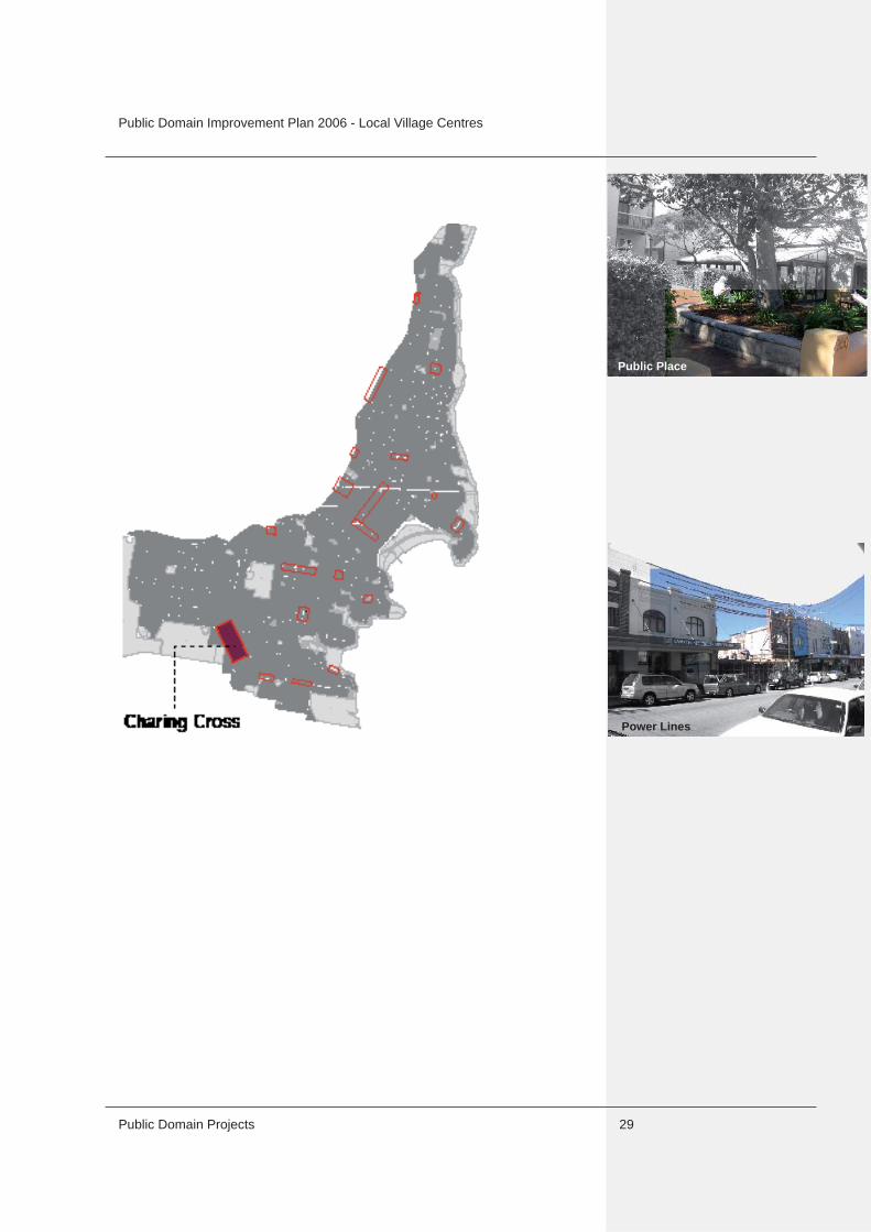
3.3 Charing Cross Small Village
3.3.1 DescriptionThe Charing Cross small village is a lively and well used tradi-tional strip with activation enhanced by cafes and pubs. It has a growing residential population within close proximity to the centre. There is, however, little amenity for people using thiscentre, with little shade and no defi ned seating or gathering area.
The distinction between commercial and residential areas is unclear at the edges of the centre, and where vehicle access lanes have been built across the commercial strip. Some recently constructed lanes lack visual quality, and have narrow and near inaccessible footpaths.
A lack of structure and defi nition in this centre is evident in inconsistent streetscape character, with unfi nished pavement treatments, and inconsistent street tree planting. The gardens and café at 282 Bronte Road, known as Mayfi eld’s Cafe provide a visual focal point.
The old post offi ce site at 234 Bronte Road is a visual focus atthe busy intersection, but the public domain is currently run down, and dominated by power lines. The bus stop on western side of the post offi ce site is crossed by a vehicle entry to residential parking creating potential danger and inconvenience for pedestrians.
3.3.2 Desired future characterImprove pedestrian amenity and safety, and create focal points to encourage people to stay and socialise in the public domain. Upgrade streetscape to create a memorable and attractive centre. Create a clear distinction between residential and com-mercial areas.
Side Lane
Public Domain Improvement Plan 2006 - Local Village Centres
Public Domain Projects 29
,...???
Power Lines
Public Place

Public Domain Improvement Plan 2006 - Local Village Centres
Public Domain ProjectsPage No.F4 30
3.3.3 Charing Cross - PotentialStreetscape
• Complete upgrade of streetscape consistent with recent paving and furniture works.
Signifi cant Sites• Form a small civic space in front of the old post offi ce and
create a new public place at 282 Bronte Road.
Lanes• Upgrade laneways through new paving, street tree planting
and improvements to building facades where possible, to unify streetscape, defi ne transition to residential areas and enhance pedestrian amenity.
Residential Interface• Intensify street tree planting in residential areas to better defi ne the break between residential and commercial uses;

Public Domain Improvement Plan 2006 - Local Village Centres
Public Domain Projects 31
• Investigate the possibility of providing an extra pedestrian crossing at the 282 Bronte Road (Mayfi eld’s Cafe) focal point.
Water Sensitive Urban Design• Potential for bio retention tree pits for new tree planting.
3.3.4 Charing Cross - Detail1 Reduce ‘private’ grassed area, defi ne with planting;2 Remove existing low wall, repave space, add tree planting
along boundary and street to create a public seating space and improve setting for café;
3 Upgrade lane, provide pedestrian path on northern side; and4 Small street trees in parking lane and enhance streetscape.
Paving• Retain existing paving and upgrade to match where necessary
along street, P3 in civic spaces. New paving in lane to match streetscape.
Street Furniture and Lighting• Town and park SSE/SS and WBSE/SS;• Pedestrian lighting under awnings, pole top lighting in civic
space; and• Bin near bus stop and at pedestrian crossing.
Landscape• Larger street trees at interface of Bronte Road and Albion St;• Small street trees at Mayfi elds Cafe.
Power lines• Underground powerlines at post offi ce site and Mayfi elds Cafe.
3
5
4
5
1
2

Public Domain Improvement Plan 2006 - Local Village Centres
Page No.F4 Public Domain Projects32
3.4 Murray Street Neighbourhood Centre
3.4.1 DescriptionA small group of shops with an intimate scale and community character, activated by a café with outdoor dining. The shops and the cafés are located on Belgrave Street, removed from the busier traffi c of Murray Street. The centre sits at a low point, creating a sense of enclosure and intimacy.
Small landscape reserves defi ne the northern section of this centre. The use of Jessie Street Reserve is restricted by slopes and lack of access. The playground is bordered by high planting which restricts surveillance from the street. The residential property on the eastern side overlooks the park, but the lack of separation potentially privatises the park. The northern entry to this playground is over a private driveway.
Belgrave Street is poorly separated from the commercial zone. The wide verge on the northern side has potential for well developed landscape, away from power lines.
3.4.2 Desired future characterEnhance conditions for outdoor dining. Improve the image and function of the reserves as a community focus and facility.
Corner Shop

Public Domain Improvement Plan 2006 - Local Village Centres
Public Domain Projects 33
Jesse Street Reserve

Public Domain Improvement Plan 2006 - Local Village Centres
Public Domain ProjectsPage No.F4 34
3.4.3 Murray Street - PotentialStreetscape
• Extend and upgrade paving in front of the shop and café. The centre is potentially a great family area. • Create better opportunities for gathering, sitting and casual
social interaction in reserves.
Residential Interface• Intensify street tree planting, outside of infl uence of powerlines,
to defi ne and separate residential area.
Parks and reserves• Upgrade landscape of parks to allow better and safer access,
and to improve functionality.
Water Sensitive Urban Design• Potential for diverting some runoff from Murray Street to water
landscape.
3.4.4 Murray Street - Detail1 Extend kerb, fully pave;2 Generous paved area, contiguous with footpath, with seating,
to form a gathering space;3 Create a series of useable terraces, some planted, some open
grass to diversify potential use; 4 Restrict parking with bollards and planting;5 Relocate gate and path to create more visible, safer entry;
repave to defi ne as public space, restrict parking with signage ; and
6 Wide band of small trees to separate park from adjacent residence, use light canopy trees to enhance passive
surveillance.

Public Domain Improvement Plan 2006 - Local Village Centres
Public Domain Projects 35
Paving• General - washed concrete paving with sawcut pattern - P1.
Street Furniture and Lighting• Town and park SSD/SS seating in reserves and at edges;• Pedestrian lighting under awnings; and• Standard bin near edge of reserve.
Landscape• Street trees to residential areas; and• Landscape to parks – community consultation for design
Power lines• Aerial bundle powerlines on Belgrave Street.
1
2
3
5
4
6

Public Domain Improvement Plan 2006 - Local Village Centres
Page No.F4
Post Offi ce
Bondi Road West 3.5 Bondi Road Village
3.5.1 DescriptionBondi Road is a major transport spine connecting the regional centre of Bondi Junction to Bondi and to Bondi Beach. The centre provides access to schools, shops, community facilities and residential areas. The mixture of commercial and residential uses along the street creates a series of traditional shopping strips, with a diverse range of services.
The commercial centre is lively with continuous pedestrian movement. The centre serves a wide area beyond the immediate residential community. Traffi c - private and public transport, is constant and slow moving. The centre has little comfort or amenity provided for pedestrians, meaning that there is little incentive or opportunity to use the street as a social space.
The character of the commercial centre is discontinuous and not well defi ned. Street trees along Bondi Road are scattered, located mainly in front of residential developments that are setback from the building line. These areas of green act as counterpoints to the commercial strips, interrupting the urban character of Bondi Road.
3.5.2 Desired Future CharacterImprove amenity for pedestrians by creating small public spaces as a focus for shoppers and community, with shade, seating, etc.Upgrade the image through streetscape improvements. The defi nition of commercial strips, and separation from residential areas should be enhanced.

Public Domain Improvement Plan 2006 - Local Village Centres
Public Domain Projects 37
Petrol Station
Traffi c Barrier

Public Domain Improvement Plan 2006 - Local Village Centres
Public Domain ProjectsPage No.F4 38
3.5.3 Bondi Road West_PotentialSignifi cant sites
• Potential major focal spaces at the Post Offi ce site and at the existing street closure at the corner of Avoca Street and Bondi Road (see detail) to provide space and facilities for gathering, seating and resting, and to improve the image of the centre.
Signifi cant built elements• Enhance the Post Offi ce building as a visual and social focal
point in the street, through upgrade to painting and signage.
Streetscape• Upgrade streetscape with consistent paving and furniture.
Residential interface• Supplement street tree planting and introduce kerb extensions
where possible to enhance separation of residential streets.
Water Sensitive Urban Design• Potential for bio retention tree pits at Avoca Street.
Lanes• Upgrade pavement and planting to make lanes a part of the
public domain.

Public Domain Improvement Plan 2006 - Local Village Centres
Public Domain Projects 39
3.5.4 Bondi Road West_Detail1 Extend kerb to create a wide pedestrian zone linking the Avoca Street closure to Bondi Road;2 Defi ne vehicle crossover as a shared space;3 Create a focal point at the corner of Avoca Street that
integrates with the service station landscape; 4 Defi ne seating area with contrasting paving material; and5 Extend street closure to include tree planting, seating and
planting.
Paving• Washed concrete with saw cut pattern (P1) as base paving,
with trim of concrete unit pavers (P2); • Special paving (P3) to defi ne extended pedestrian space; and• Cobblestones (P4) to defi ne pedestrian interface with carriage-
way at Avoca Street.
Street Furniture and Lighting• Town and Park SSE/SS seats along Bondi Road generally,
with special seating, including WBSE/SS at focal points in front of Post Offi ce and at Avoca Street;
• Pedestrian lighting under awnings; and• One standard bin for every block, located at bus stops or street
corners.
Landscape• Remove small under awning planting, concentrate planting at
Avoca Street and Post Offi ce.
1
5
2
3
4

Public Domain Improvement Plan 2006 - Local Village Centres
Public Domain ProjectsPage No.F4 40
3.5.5 Bondi Road East_PotentialSignifi cant sites
• Create a pedestrian focal point at the corner of Denham Street and Bondi Road.
Streetscape• Upgrade streetscape with consistent paving and furniture.
Residential interface• Supplement street tree planting and introduce kerb extensions
where possible to enhance separation of residential streets.
Water Sensitive Urban Design• Bio retention tree pits in streetscape of focal point at corner of
Denham Street.
Lanes• Upgrade streetscape to make lanes a part of the public
domain (i.e. Castlefi eld Lane and Royal Lane).

Public Domain Improvement Plan 2006 - Local Village Centres
Public Domain Projects 41
3.5.6 Bondi Road East_Detail1 Extend kerb to expand pedestrian space and reduce width
of crossing;2 New street tree; and3 New paving and streetscape elements.
Paving• Generally - Washed concrete with saw cut pattern (P1) as base
paving, with trim of concrete unit pavers (P2); • Special paving (P3) to defi ne extended pedestrian space; and• Cobblestones (P4) to defi ne pedestrian interface with carriage-
way at Denham Street only.
Street Furniture and Lighting• Town and Park SSE/SS seat along street generally, with special seating at focal points;• Pedestrian lighting under awnings; and• One standard bin for every block, located at bus stops or street
corners.
Landscape• Remove small under awning planting, concentrate planting at
Denham Street corner.
Public Art• Possible pavement artwork interpreting old tram route.
1
23

Public Domain Improvement Plan 2006 - Local Village Centres
Public Domain ProjectsPage No.F4 42
3.6 Old South Head Road Neighbourhood Centres (at Murriverie Road, Blair Street and Flood Street)
3.6.1 DescriptionOld South Head Road is one of two major roads connecting the peninsula of Rose Bay, Vaucluse and Watsons Bay to Bondi Junction and the city. It also provides a major connection to North Bondi.
Old South Head Road links commercial centres, and provides access to residential areas, places of worship and community facilities. Old South Head Road carries high volumes of traffi c, including buses.
There are fi ve commercial centres of various sizes located along Old South Head Road. The two small village centres in the northern section (Rose Bay north and south) are considered in Section 3.11.
The centres at the central and southern sections of Old South Head Road are neighbourhood centres and located at the intersections with Murriverie Road, Blair Street and Flood Street. The centre at the major intersection of Blair Street and Old South Head Road extends into Curlewis Street, where a few shops add to the diversity and character. Curlewis Street has a poor visual quality and lacks amenity for the shopping and residential community. The diversion of traffi c at Blair Street has created a small green space at the meeting point of Blair and Curlewis streets.
The two remaining centres, at the intersection with Flood Street and at the intersection with Murriverie Road are small, containing commercial outlets, with little pedestrian activity. Improvements to the public domain of these centres is of low priority, and should aim to upgrade the image of these centres.
3.6.2 Desired future character Old South Head Road South (Flood Street)The Old South Head Road South Centre has little pedestrian movement and therefore a low priority for a public domain upgrade. Improvements to paving should accompany changes to the built form and/or function. Old South Head Road Central (Blair Street)The Old South Head Road Central Centre is a signifi cant intersection with potential for change. Upgrade of the landscape image at the major intersection should be undertaken. Additionally, the image and pedestrian amenity in the commer-cial centre should be improved. Enhance the quality of, and access to green spaces.
This intersection has been earmarked for gateway signage in Council’s Looking Good Strategy.
Central

Public Domain Improvement Plan 2006 - Local Village Centres
Public Domain Projects 43
Flood Street
Blair Street
Murriverie Road
South

Public Domain Improvement Plan 2006 - Local Village Centres
Public Domain ProjectsPage No.F4 44
3.6.3 Old South Head Road (Murriverie Road and Flood Street)_PotentialStreetscape
• Upgrade streetscape through new paving - washed concrete with saw cut pattern, P1 for both centres. Provide greater
separation from the residential part of Murriverie Road through a kerb extension on the corner of Old South Head Road.
Residential interface• Enhance street tree planting in residential areas.
Old South Head Road North (Murriverie Road)
Old South Head Road South (Flood Street)

Public Domain Improvement Plan 2006 - Local Village Centres
Public Domain Projects 45
3.6.4 Old South Head Road (Blair Street)_PotentialSignifi cant sites
• Upgrade landscape at intersection and provide gateway signage.
The triangular site bounded by Curlewis and Blair Street currently has a negative visual impact , with open car yards:
• Allow for future development accompanied by streetscape upgrade; and
• Enlarge the green space to provide a small local park and create a visual focus at the intersection of Blair Street and Curlewis Street.
Streetscape• Upgrade streetscape on Curlewis Street.
Residential interface• Improve street tree planting on residential streets to defi ne and
separate from the commercial centre.
Water Sensitive Urban Design• Potential for bio retention tree pits along Curlewis Street, and
capture and reuse of runoff at Blair Street median strip.

Public Domain Improvement Plan 2006 - Local Village Centres
Public Domain ProjectsPage No.F4 46
3.6.5 Old South Head Road (Blair Street)_Detail1 Streetscape upgrade with new paving and street tree planting;2 New planting to enhance the image of the intersection as a focal point in the landscape, new gateway signage; and3 Extend the median strip to enlarge the existing green space
and provide a useable public space that enhances the existing green space network.
Paving• Washed concrete with saw cut pattern (P1); and • Cobblestones (P4) on median strips where not planted.
Street Furniture and Lighting• Town and Park SSD/SS and WBSE/SS seating;• Pedestrian lighting under awnings; and• One standard bin for every block, located at bus stops or street
1
2
1

Public Domain Improvement Plan 2006 - Local Village Centres
Public Domain Projects 47
corners.
Landscape• Street trees along Curlewis Street and Blair Street.
3

Public Domain Improvement Plan 2006 - Local Village Centres
Page No.F4 48
3.7 Hall Street Town Centre
3.7.1 DescriptionThe lower part of Hall Street, south of the Glenayr Avenue intersection, provides an extension of the commercial activity and pedestrian use of Campbell Parade, but with a more intimate spatial quality created by topography and defi ned by a consistent built edge. Hall Street is a busy street with a lot of pedestrian traffi c, serving both visitors and the local community. The commercial centre provides a number of cafes with outdoor dining, which are clustered and concentrated into the existing footpaths. The commercial centre offers little public amenity in terms of seating, shade, or visual character.
The following potential pedestrian focal points have been identi-fi ed along the Hall Street commercial centre: at the corner of Glenayr Avenue, where an existing street closure extends over the pedestrian footpath, and couples with the kerb extension opposite to form a gateway to the village centre; and at the Post Offi ce site, where the building is set back, an opportunity for a small civic space is provided.
Residential streets are separated from the commercial centre by planted kerb extensions. These areas are often degraded and detract from the quality of Hall Street. Further street tree planting in the residential streets contributes to the character of the Hall Street commercial centre.
3.7.2 Desired future characterUpgrade the streetscape to create a consistent street. Create public focal points that contribute to the amenity of the street. Improve pedestrian amenity and reduce the dominance of vehicular traffi c. Enhance the separation between the commer-cial centre and the adjoining residential streets.
48

Public Domain Improvement Plan 2006 - Local Village Centres
Public Domain Projects 49
Awnings obstructing tree growth
Kerb extensions as public niches

Public Domain Improvement Plan 2006 - Local Village Centres
Public Domain ProjectsPage No.F4 50
3.7.3 Hall Street - PotentialSignifi cant sites
• The Post Offi ce building is set back, thus extending the pedes- trian environment and providing an opportunity for a focal point;
• Enhance paving and landscape at existing kerb extensions to provide green pockets along the street.
See details following for all sites.
Signifi cant buildings• Enhance the Post Offi ce building - encourage upgrade to
facade and pedestrian access.
Streetscape• Upgrade streetscape with new paving, furniture and lighting.
Residential interface• Enhance the separation of the Hall Street commercial centre
from adjoining residential streets through kerb extensions and landscape.
Access and Transport• Kerb extensions to calm traffi c at residential street intersec- tions.
Water Sensitive Urban Design• Potential for diverting runoff to street trees and planted areas.

Public Domain Improvement Plan 2006 - Local Village Centres
Public Domain Projects 51
3.7.4 Intersection of Hall Street and Cox Avenue At the Finance, Ethics and Strategic Committee meeting held on
6 February 2007, it was resolved that the area at the intersec-tion of Hall Street and Cox Avenue be seperately considered by Council and details of this will be determined by the Divisional Manager, Technical Services in March 2007 and then incorper-ated into the Public Domain Improvement Plan following its adoption by Council.

Public Domain Improvement Plan 2006 - Local Village Centres
Public Domain ProjectsPage No.F4 52
3.7.5 Chambers Avenue + Consett Avenue_ Detail1 Kerb extensions and paving defi ne a break in the
ordinary street condition; 2 Upgrade planting to create green pockets and
enhance separation between commercial centre and adjoining residential streets; and
3 New seating for pedestrian amenity.
Paving• Washed concrete with saw cut pattern as base paving
(P1) with trim of concrete unit pavers (P2); and• Special paving (P3) to defi ne extended pedestrian
space.
Street Furniture and Lighting• Town and Park SSE/SS along street, with special
seating including WBSE/SS at focal points - Glenayre Avenue intersection and Post Offi ce site;
• Pedestrian lighting under awnings; and• One standard bin for every block, located near pedes-
trian crossings or at street corners.
Landscape• Remove small under awning planting, concentrate
planting at Glenayre Avenue intersection and Post Offi ce site focal points.
23
1
222
1
3

Public Domain Improvement Plan 2006 - Local Village Centres
Public Domain Projects 53
3.7.6 Jaques Avenue_ Detail1 Remove planter boxes to enhance pedestrian movement and
create seating and gathering spaces; 2 Create a wider civic space through kerb extensions on both
sides of the street;3 New street tree planting to provide a green pocket along the
street; and4 Upgrade paving and streetscape elements, with special
elements to defi ne as a civic space.
Paving• Washed concrete with saw cut pattern as base paving (P1) with
trim of concrete unit pavers (P2);• Special paving (P3) to defi ne extended pedestrian space.
Street Furniture and Lighting
• Town and Park SSE/SS along street, with special seating including WBSE/SS at focal points - Glenayre Avenue inter- section and Post Offi ce site;• Pedestrian lighting under awnings; and• One standard bin for every block, located near pedestrian crossings or at street corners.
Landscape• Remove small under awning planting, concentrate planting at
Glenayre Avenue intersection and Post Offi ce site focal points.
5
2
3
41
24
4
2
1

Public Domain Improvement Plan 2006 - Local Village Centres
Public Domain ProjectsPage No.F4 54
3.8 Glenayr Avenue Neighbourhood Centre
3.8.1 DescriptionGlenayr Avenue connects the transport spines of Blair Street and O’Brien Street, supporting the 389 bus route connection toBondi Junction and the city. It supplements the commercial centre of Hall Street and Campbell Parade with a mix of retail, commercial and residential uses.
The condition changes along its length from built to street edgeretail and commercial premises, to set back residential buildings.This mix produces a series of shopping strips of local scale and character, divided by residential areas that are complemented by garden planting and by mature street trees.
Glenayr Avenue is contained by major intersections at either end, forming a small civic space accommodating outdoor dining and landscape. The intersection at ‘Seven Ways’ has recently undergone extensive redesign and construction to create an improved open space environment, along with traffi c calming measures. The intersection at Hall Street is considered under Section 3.7.
3.8.2 Desired Future CharacterReinforce the two principal intersections at the ends of Glenayr Avenue, and the minor focal point formed at the intersection with Curlewis Street. Retain the fully paved verge along the entire Avenue, and enhance the pedestrian environment through upgrade to paving, street furniture and connections to public transport.
Spread out commercial activity

Public Domain Improvement Plan 2006 - Local Village Centres
Public Domain Projects 55
Focus of Public Life
Character side street

Public Domain Improvement Plan 2006 - Local Village Centres
Public Domain ProjectsPage No.F4 56
3.8.3 Glenayr Ave_ PotentialSignifi cant sites
• Enhance the ‘Seven Ways’ intersection as a social and visual focal point; and
• Retain the reserve as a signifi cant green space for community use and contribution to streetscape character.
Streetscape• Upgrade streetscape, defi ne commercial areas through paving,
Type P1 generally, with P2 at corner of Curlewis Street to defi ne a minor focal point in the street.. Access and Transport
• Traffi c calming measures at ‘Seven Ways’ intersection.
Water Sensitive Urban Design• Potential for diverting runoff to soft landscape at ‘Seven Ways’.

Public Domain Improvement Plan 2006 - Local Village Centres
Public Domain Projects 57
3.8.4 Detail1 New paving and streetscape elements in commercial centres; 2 New paving, seating and landscaping to upgrade to small public
space; 3 Planting of the median strip along Blair Street; and4 Future upgrade to green space.
Paving• Generally - Washed concrete with saw cut pattern (P1) as base
paving, with trim of concrete unit pavers (P2); • Special paving (P3) to defi ne extended pedestrian space at
cafes; and • Cobblestones (P4) to be used to defi ne pedestrian interface
with carriageway.
Street Furniture and Lighting• SSD/SS along street generally, with special seating at Seven
Ways focal point;• Pedestrian lighting under awnings; and• One standard bin for every block, located at bus stops or street
corners.
Landscape• Planting of the median strip along Blair Street, in the landscape
reserve and on the edge of the outdoor dining area.
1
2
3
4
1

Public Domain Improvement Plan 2006 - Local Village Centres
Public Domain ProjectsPage No.F4 58
3.9 North Bondi Neighbourhood Centre
3.9.1 DescriptionNorth Bondi consists of two centres – one larger centre at Campbell Parade, and a smaller centre at Wairoa Avenue. The larger centre consists of a group of shops, including foodoutlets, and the terminus for the 389 bus route service. The shops predominantly service the local community, but also visitors to Bondi Beach. The Campbell Parade centre is dominated by the bus terminus, with a poor pedestrian environment, restricted movement, and lack of seating and shelter. It has a poor landscape image.
The smaller centre at Wairoa Avenue provides cafes with outdoor dining, and has good connections to small local parks. This centre has an intimate scale with a community focus, buthas to cope with the traffi c coming from Blair Street and Campbell Parade.
3.9.2 Desired future character.Retain the local character at both centres. Improve the pedestrian environment at the bus terminus, clarify pedestrian circulation, and improve access to buses. Investigate kerb realignments to increase pedestrian reserves in central area. Investigate options to ‘green’ the central spine.
Public domain improvements have not been identifi ed for the Wairoa Avenue centre, due to the limited size.
North Bondi Centre

Public Domain Improvement Plan 2006 - Local Village Centres
Public Domain Projects 59
Bus stop building partly unused

Public Domain Improvement Plan 2006 - Local Village Centres
Public Domain ProjectsPage No.F4 60
3.9.3 North Bondi - PotentialSignifi cant SitesThis centre is on the edge of a ridge with good views to Bondi Beach and the ocean, and is visible from many surrounding areas. The central median strip and the bus terminus dominate the street, but are of poor visual quality and low amenity.
• Upgrade the public domain to provide a positive landscape image, and improve amenity for pedestrians and commuters.
Signifi cant built elementsThe existing building of the bus terminus provides facilities for bus drivers, however, it is currently underutilized.
• Investigate opportunities for refurbishing building.
Streetscape• Upgrade streetscape with new paving, street furniture and
tree planting.
Residential interface• Reinforce separation from residential streets through kerb
extensions and planting.
Access and Transport• Provide a break in the median at pedestrian at pedestrian
crossing to improve equal access.

Public Domain Improvement Plan 2006 - Local Village Centres
Public Domain Projects 61
3.9.4 North Bondi - Detail1 New paving and streetscape elements;2 Extend kerb to increase pedestrian space and allow street tree planting;3 Refurbish existing building at bus terminus to ease pedestrian movement, accommodate bus drivers, and to provide more
sheltered space for commuters; 4 Possible future kerb extensions (subject to traffi c study);5 Planting to median strip, with possible tall trees to emphasise
ridge; and6 Break in median to improve access on pedestrian crossing.
Paving• Generally - Washed concrete with saw cut pattern as base
paving (P1), with trim of concrete unit pavers (P2).
Street Furniture and Lighting• Town and Park SSE/SS along street generally, with special
seating at bus terminus;• Pedestrian lighting under awnings; and• One standard bin for every block, located at bus terminusand
at street corner.
Landscape• Tall trees to mark visual high point.
1
3
2
5
5
6
3
4

Public Domain Improvement Plan 2006 - Local Village Centres
Public Domain ProjectsPage No.F4 62
3.10 Murriverie Road Neighbourhood Centre
3.10.1 DescriptionThe Murriverie Road commercial centre is a small centre of shops and services, serving a local residential population only.The centre is small in scale and has a relatively intimate character.
The shops on the corner of Mitchell Street and Murriverie Road are set back from Mitchell Street, potentially forming a small public square, which however, is of very poor visual quality, dominated by powerlines and parking.
The centre has a small playground at the western end of the centre, which is predominantly locally used. The quality of the playground equipment, furniture and paving is poor. Graffi ti has been sprayed on the built edges, giving it a run down appearance. Mature trees within the playground and in the adjacent street are its major assets, creating a landscape focal point in the street and providing shade and shelter.
3.10.2 Desired future characterRetain the local character, and upgrade the image with improvements to the streetscape and landscape. Enhance the social and visual focal points in the street, and the opportunities for social interaction and recreation.
It should be noted that the playground is not currently zoned open space.

Public Domain Improvement Plan 2006 - Local Village Centres
Public Domain Projects 63
playground

Public Domain Improvement Plan 2006 - Local Village Centres
Public Domain ProjectsPage No.F4 64
\
3.10.3 Murriverie Road - PotentialSignifi cant Sites
• Take advantage of setbacks to create a small public square at the corner of Murriverie Road and Mitchell Street; and
• Enhance the character and amenity of the existing playground on Murriverie Road. This site should be rezoned as public space. See detail.
Streetscape• Upgrade streetscape with new paving, street furniture and
street trees.
Residential interface• Reinforce separation from adjoining residential streets by
supplementing street tree planting.
Parks and reserves• Upgrade facilities and paving of the playground.
Water Sensitive Urban Design• Opportunity for diverting runoff for irriagtion of landscape in playground area.

Public Domain Improvement Plan 2006 - Local Village Centres
Public Domain Projects 65
3.10.4 Murriverie Road Playground - Detail1 New paving and streetscape elements;2 Artwork/ screen on walls to enhance edge and deter vandalism;3 Nature play area under exisiting Paperbark trees, with locally
indigenous planting;4 New low wall, with access to nature play area; 5 Renew playground surface and path through; and6 Replace all treated pine fences and play equipment.
Paving• Generally - Washed concrete with saw cut pattern (P1) for
footpaths to Glenayr Avenue and Murriverie Road. Paving and furniture within the playground should be selected (non standard) to suit design concepts for this space.
2
45
326
6
1
P1

Public Domain Improvement Plan 2006 - Local Village Centres
Public Domain ProjectsPage No.F4 66
3.11 Rose Bay Small Villages (North and South)
3.11.1 DescriptionThe two northern local village centres are larger shopping strips, occupying both sides of the Old South Head Road, which forms the border between Waverley and Woollahra local government areas. These centres have higher pedestrian movement, less vehicle traffi c, and the effect of traffi c movement mitigated by parking on both sides. Paving and streetscape details have been upgraded on the Woollahra side. Some recent upgrading of streetscape has been undertaken on the Waverley side of both centres, to match streetscape on the Woollahra Council side.
Both centres are well separated from residential areas through generous and mature street tree planting.
3.11.2 Desired future character Retain the existing character of these centres, and complete the streetscape upgrade to match the Woollahra side.

Public Domain Improvement Plan 2006 - Local Village Centres
Public Domain Projects 67

Public Domain Improvement Plan 2006 - Local Village Centres
Public Domain ProjectsPage No.F4 68
3.11.3 Small Village Centre Rose Bay South_PotentialStreetscape
• Complete streetscape upgrade to match the Woollahra Council side.
See the Local Village Centres Technical Manual for details of streetscape elements.

Public Domain Improvement Plan 2006 - Local Village Centres
Public Domain Projects 69
3.11.3 Small Village Centre Rose Bay North_PotentialStreetscape
• Complete streetscape upgrade to match the Woollahra Council side. See the Local Village Centres Technical Manual for details of streetscape elements.
Residential interface• Reinforce separation from adjoining residential streets by
supplementing street tree planting.
Lanes• Upgrade streetscape to include lanes in public domain - lanes
should provide pedestrian and vehicle access, and be visually upgraded.

Public Domain Improvement Plan 2006 - Local Village Centres
Page No.F4 Public Domain Projects70
3.12 Blake Street Neighbourhood Centre
3.12.1 DescriptionThe Blake Street neighbourhood centre is a very small centre with a cluster of shops and commercial buildings at the corner of Blake Street and Military Road. The centre serves a local community and passing traffi c. The centre is located on a high ridge with views west down Blake Street to the harbour and city.
The public domain comprises a footpath and grass verge on the western side, and paved footpath on the eastern side, with extended paving where buildings are set back. Paving and streetscape details are of poor quality.
3.12.2 Desired future character.The centre has the potential to create a focal point for the local community. This could be achieved through improvements to the streetscape to enhance opportunities for social interaction and outdoor dining.

Public Domain Improvement Plan 2006 - Local Village Centres
Public Domain Projects 71
Harbour views

Public Domain Improvement Plan 2006 - Local Village Centres
Public Domain ProjectsPage No.F4 72
3.12.3 Blake Street - PotentialSignifi cant Sites
• Take advantage of setbacks and kerb extensions to create small seating or outdoor dining areas on the corner of Blake
Street and Military Road.
Signifi cant views• Retain and enhance views to the harbour.
Streetscape• Upgrade streetscape with new paving and street furniture.
Residential interface
• Reinforce separation from adjoining residential streets by supplementing street tree planting along the eastern portion of Blake Street.

Public Domain Improvement Plan 2006 - Local Village Centres
Public Domain Projects 73
3.12.4 Blake Street - Detail1 New paving and streetscape elements.
Paving• Generally - Washed concrete with saw cut pattern (P1).
Street Furniture and Lighting• Town and Park SSD/SS seats along street, provide one seat
each side of Military Road; and• One standard bins at shops eastern side only.
1
1