
Land or Site Description Wayne Foss, MBA, MAI Wayne Foss Appraisals, Inc. Email: [email protected].

Local Plan Site Appraisals – November 2018
Sites not included in the Submission Plan
Appendix 3

EM1 ‐ LAND SOUTH OF HIGH STREET, BRASTED

SITE AVAILABILITY ASSESSMENT
SHELAA ref EM1 / HO8 SHELAA category 4 SHELAA conclusion Deliverable SHELAA yield B1(a) office floorspace SHELAA density 30‐40 DPH When will development be delivered?
1 – 5 years
Will an existing use be lost? If yes, what?
Grassland
Access requirements Existing access onto High Street could be utilised. Car parking arrangements are not clear.
Green Belt strength & boundary issues
Green Belt strength: Strong Weakly performing parcel: RA‐10 Partially located within Brasted urban confines
Viability issues No constraints that could render the site financially unviable. New infrastructure and community benefits
None
Input from technical specialists
Conservation Kent Downs AONB Unit
Other considerations Additional information on site layout and massing is required alongside an assessment of the impact on the conservation area and listed building.
Deliverability summary Red – due to heritage constraints. STAGE 1 SITE APPRAISAL CONCLUSION Deliverability summary Red – due to heritage constraints. Key messages from SA Conservation Area
Listed Building Kent Downs AONB School
Land Use Employment Developable area (ha) 0.08 Density N/A Site capacity B1a Phasing 1 – 5 years Overall conclusion
Include in plan, subject to further information

SITE CONSIDERATIONS EM1 – Land South Of High Street, Brasted Land use / existing use
Brownfield or PDL
Is site in the Green Belt?
Yes
Green Belt recommended area (RA)‐ weakly performing
Partially within an RA‐ 90.4%
Wider Green Belt parcel strength
Strong GB Parcel ID – 36
Strategic gap (SG) Not in a SG
Adjacent to settlement boundary
Fully adjacent – Brasted Partially within Settlement Boundary
Settlement hierarchy
Within or adjacent to lower tier settlement
Proximity to public transport/services
Within walking distance of public transport and existing services and facilities including…
Public Transport Shops
AONB Fully within AONB
Agricultural land quality
Urban
Landscape sensitivity
Low
Optimum density N/A
ADDITIONAL INFORMATION REQUIREMENTS (for yellow sites only) What information was requested?
Conclusion
Additional information – car parking
No response received
Heritage Impact – site layout and massing
No response received

SUMMARY OF CONSULTATION COMMENTS Site promoter No comments received
Infrastructure providers No comments received
Statutory consultees Natural England ‐ Designation Impacted ‐ Kent Downs AONB.
What should be considered for this allocation? ‐ Each policy needs to consider the site’s location within the AONB, ensuring the character of the AONB is protected and enhanced, with reference to the Management Plan, NCA and LCA. Significant Concerns – None. Further advice ‐ See detailed comments on Policy 3(Landscape and AONB).
Public including Town/Parish Councils
General Public Comment Summary ‐ Need to ensure the AONB is protected
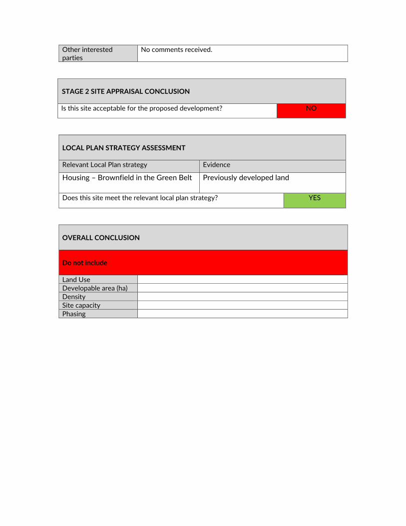
Other interested parties
No comments received
STAGE 2 SITE APPRAISAL CONCLUSION Is this site acceptable for the proposed development? NO
LOCAL PLAN STRATEGY ASSESSMENT Relevant Local Plan strategy Evidence
Employment – close to settlement Employment need can be met on other more suitable sites
Does this site meet the relevant local plan strategy? NO
OVERALL CONCLUSION
DELIVERY The landowner has failed to demonstrate that the development would not have an unacceptable impact on heritage and the historic environment. Conclusion Unsuitable

Do not include Land Use Developable area (ha) Density Site capacity Phasing

EM4 ‐ LAND AT PEDHAM PLACE, SWANLEY

SITE DELIVERABILITY ASSESSMENT
SHELAA ref EM4 SHELAA category 4 SHELAA conclusion B1‐B8 floorspace SHELAA yield SHELAA density N/A When will development be delivered?
1‐5years
Will an existing use be lost? If yes, what?
Agricultural land and land used for car boot sales
Access requirements Existing Access can be used onto the A20 Green Belt strength & boundary issues
Green Belt Strength: Strong Adjacent to Swanley and junction 3 of M25
Viability issues None New infrastructure and community benefits
None
Input from technical specialists
Kent Downs AONB Unit ‐ Objection ‐ elevated position, introduction of substantial built form into undeveloped landscape, unrelated to existing settlement pattern. Environment Agency ‐ We understand that this site partially overlies a historic landfill site, and could therefore encounter significant problems associated with landfill gas, leachate production, drainage issues and foundation solutions. The site is also located within source protection zones for various groundwater abstractions. Although dependent on the ground conditions present at the site, a development may not be considered appropriate at this location.
Highways England Environmental Health
Other considerations Site area has been reduced to area close to existing employment site and strategic road network.
Deliverability summary Orange ‐ due to strategic scale of employment land, on the
strategic road and rail transport network and adjacent to high quality employment site.
STAGE 1 SITE APPRAISAL CONCLUSION Deliverability summary Orange ‐ due to strategic scale of employment land, on the
strategic road and rail transport network and adjacent to high quality employment site.
Key messages from SA Kent Downs AONB AQMA School
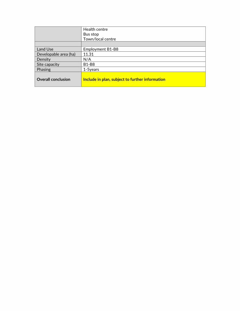
Health centre Bus stop Town/local centre
Land Use Employment B1‐B8 Developable area (ha) 11.31 Density N/A Site capacity B1‐B8 Phasing 1‐5years Overall conclusion
Include in plan, subject to further information
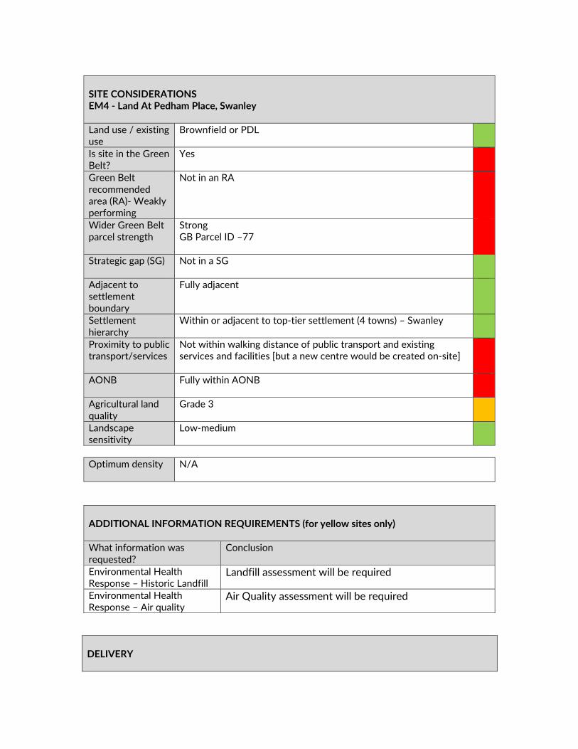
SITE CONSIDERATIONS EM4 ‐ Land At Pedham Place, Swanley Land use / existing use
Brownfield or PDL
Is site in the Green Belt?
Yes
Green Belt recommended area (RA)‐ Weakly performing
Not in an RA
Wider Green Belt parcel strength
Strong GB Parcel ID –77
Strategic gap (SG) Not in a SG
Adjacent to settlement boundary
Fully adjacent
Settlement hierarchy
Within or adjacent to top‐tier settlement (4 towns) – Swanley
Proximity to public transport/services
Not within walking distance of public transport and existing services and facilities [but a new centre would be created on‐site]
AONB Fully within AONB
Agricultural land quality
Grade 3
Landscape sensitivity
Low‐medium
Optimum density N/A
ADDITIONAL INFORMATION REQUIREMENTS (for yellow sites only) What information was requested?
Conclusion
Environmental Health Response – Historic Landfill
Landfill assessment will be required
Environmental Health Response – Air quality
Air Quality assessment will be required
DELIVERY

SUMMARY OF CONSULTATION COMMENTS Site promoter No comments received
Infrastructure providers National Grid – Site Ref: EM4 – Land at Pedham Place, Swanley
(our reference ET237) Decommissioned Underground Electricity Cable. The proposed sites are crossed by a National Grid high voltage electricity transmission overhead line and underground decommissioned electricity cable. National Grid prefers that buildings are not built directly beneath its overhead lines. This is for two reasons, the amenity of potential occupiers of properties in the vicinity of lines and because National Grid needs quick and easy access to carry out maintenance of its equipment to ensure that it can be returned to service and be available as part of the national transmission system. Such access can be difficult to obtain without inconveniencing and disturbing occupiers and residents, particularly where properties are in close proximity to overhead lines. National Grid seeks to encourage high quality and well planned development in the vicinity of its high voltage overhead lines. Land beneath and adjacent to the overhead line route should be used to make a positive contribution to the development of the site and can for example be used for nature conservation, open space, landscaping areas or used as a parking court.
Statutory consultees Natural England ‐ Designation Impacted ‐ Kent Downs AONB. Farningham Woods SSSI. What should be considered for this allocation? ‐ The policy needs to consider the site’s location within the AONB, ensuring the character of the AONB is protected and enhanced, with reference to the Management Plan, NCA and LCA. This site is within the Impact Risk Zone (IRZ) for SSSI. If the allocation is likely to have significant effects on the SSSI, appropriate mitigation measures need to be specified. Significant Concerns ‐ This allocation is for 8 large units on what appears to be largely undeveloped land (part of which may include a car park)adjacent to a golf course. Should this application be taken forward, robust measures to protect and enhance the AONB together with suitable mitigation measures should be carefully considered, and these should be specified in the policy wording for this allocation.
Public including Town/Parish Councils
Crockenhill Parish Council ‐ The Parish Council does not support any proposed development on this site which is currently used as a golf course. The main objections include: The fact that the area
The landowner has indicated that the site is available. However, it is yet to be demonstrated that the impact on the AONB and the wider transport network can be overcome. Conclusion Developable

falls under an Area of Outstanding Natural Beauty and a proposed housing development of this scale would go against the aims of the protection offered to AONBs under the Countryside and Rights of Way Act 2000. Under the CROW Act, the relevant local authority must make sure that all decisions have regard for the purpose of conserving and enhancing the natural beauty of the AONB. The Parish Council cannot support this development in relation to the Greenbelt status of the land, as it is open land, occasionally used for Boot Sales, so fulfils the openness function of the Green Belt. This development would also go against other the fundamental aims of Green Belts namely ;a) to check the unrestricted sprawl of large built‐up areas; b) to prevent neighbouring towns merging into one another; c) to assist in safeguarding the countryside from encroachment; In addition, the Parish Council is concerned about the added heavy goods traffic this site is likely to generate. Congestion is already chronic on the roads and traffic will seek side roads such as Wested Lane/ Eynsford Road leading through the centre of Crockenhill. In this regard the Parish Council would oppose any move such as contained within the Swanley Transport Study to improve/widen/put in place passing laces along Wested Lane/Eynsford Road. Farningham Parish Council ‐ Farningham Parish Council STRONGLY objects to the inclusion of the land at EM4 in SDC’s Draft Local Plan in the strongest terms. The site is within both the Green Belt and an AONB. Given that the economic land needs for Sevenoaks district is only 11.6ha, and given the brownfield sites identified elsewhere in the Local Plan, it makes little sense to build on Green Belt and the AONB. Eynsford Parish Council‐ The land is wholly within the Green Belt and AONB. There are no ‘Very Special Circumstances’ presented supporting development within the Green Belt and there is no evidence presented supporting ‘Exceptional Circumstances’ for this site. The site is bounded by the M25 and the A20 at the extreme limit of the AONB. These major roads provide a natural barrier to encroaching development from Swanley; if allowed this may be the catalyst for further development in the area. The proposal would bring HGV and other industrial vehicles onto the already congested sections of the M25 Junction 3 and the A20. This land is within an area of high air and noise pollution unsuitable for development. For these reasons the site should be withdrawn from the Draft Local Plan. Supported by all the comments above, Eynsford Parish Council strongly objects to the proposed developments MX48 and EM4 and requests that the both proposals be removed from the new Local Plan. General Public Main Issues (in order of frequency)– Roads already congested Object to the development No building on green belt / AONB / SSSI / use brownfield Traffic will increase
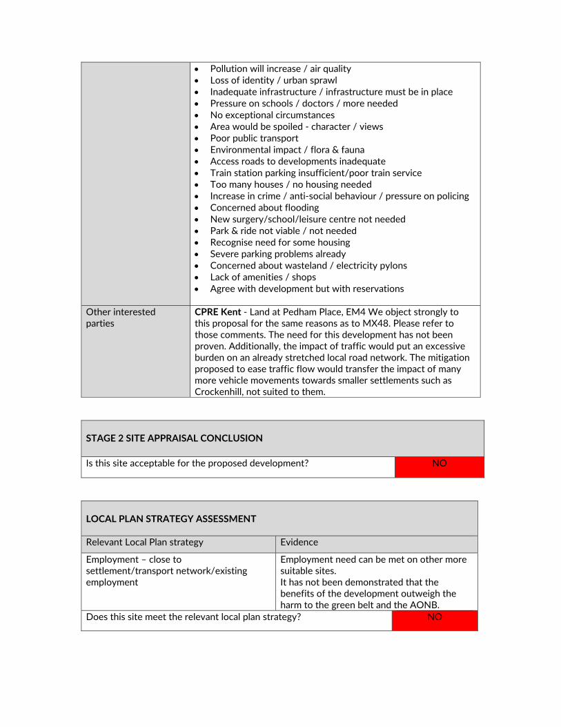
Pollution will increase / air quality Loss of identity / urban sprawl Inadequate infrastructure / infrastructure must be in place Pressure on schools / doctors / more needed No exceptional circumstances Area would be spoiled ‐ character / views Poor public transport Environmental impact / flora & fauna Access roads to developments inadequate Train station parking insufficient/poor train service Too many houses / no housing needed Increase in crime / anti‐social behaviour / pressure on policing Concerned about flooding New surgery/school/leisure centre not needed Park & ride not viable / not needed Recognise need for some housing Severe parking problems already Concerned about wasteland / electricity pylons Lack of amenities / shops Agree with development but with reservations
Other interested parties
CPRE Kent ‐ Land at Pedham Place, EM4 We object strongly to this proposal for the same reasons as to MX48. Please refer to those comments. The need for this development has not been proven. Additionally, the impact of traffic would put an excessive burden on an already stretched local road network. The mitigation proposed to ease traffic flow would transfer the impact of many more vehicle movements towards smaller settlements such as Crockenhill, not suited to them.
STAGE 2 SITE APPRAISAL CONCLUSION Is this site acceptable for the proposed development? NO
LOCAL PLAN STRATEGY ASSESSMENT Relevant Local Plan strategy Evidence
Employment – close to settlement/transport network/existing employment
Employment need can be met on other more suitable sites. It has not been demonstrated that the benefits of the development outweigh the harm to the green belt and the AONB.
Does this site meet the relevant local plan strategy? NO

OVERALL CONCLUSION Do not include Land Use Developable area (ha) Density Site capacity Phasing
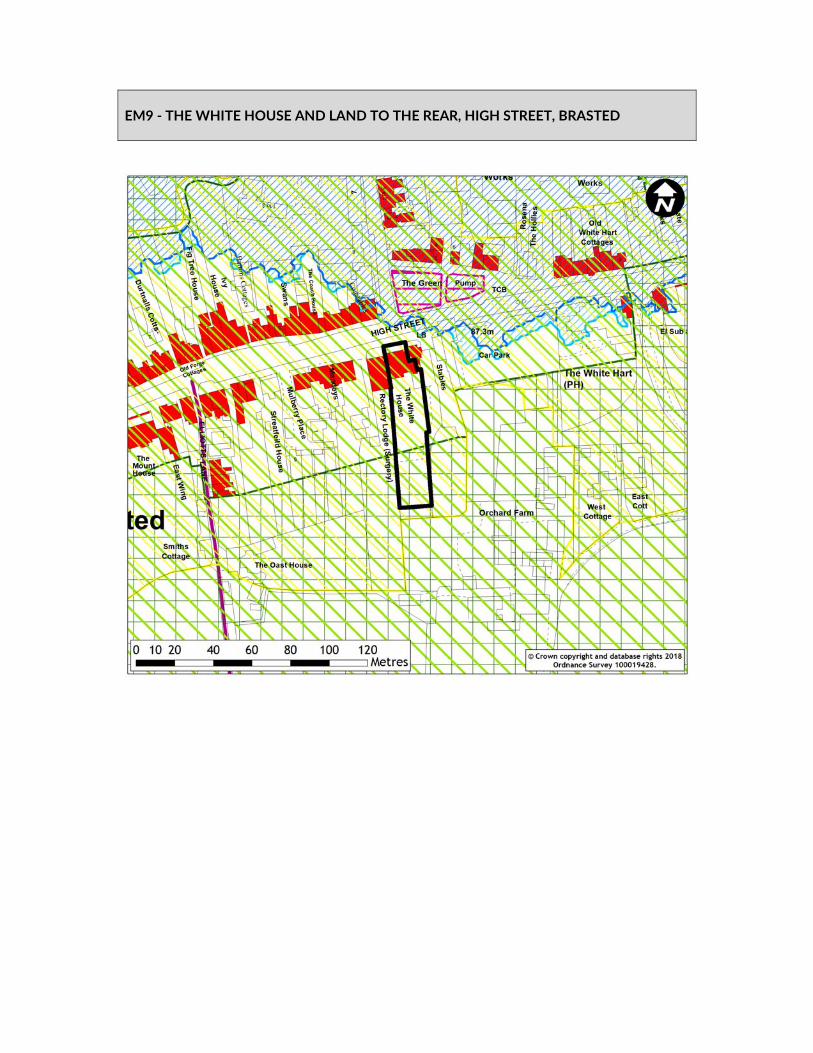
EM9 ‐ THE WHITE HOUSE AND LAND TO THE REAR, HIGH STREET, BRASTED

SITE DELIVERABILITY ASSESSMENT
SHELAA ref EM9 / HO173 / MX23 SHELAA category 1 SHELAA conclusion Deliverable SHELAA yield B1 (a) floorspace SHELAA density 30‐40 DPH When will development be delivered?
1‐5 Years
Will an existing use be lost? If yes, what?
Land rear to existing offices used for car parking.
Access requirements Existing access onto High Street can be utilised. Green Belt strength & boundary issues
Strength: Strong Weakly performing parcel: RA‐10
cViability issues No constraints that could render the site financially unviable are identified at this time.
New infrastructure and community benefits
None
Input from technical specialists
Kent Downs AONB Unit – No objection in principle, but would not wish to see the loss of the historic White House, as this important building in the village contributes to the historic character of the Kent Downs AONB. Conservation
Other considerations Additional information on site layout and massing is required alongside an assessment of the impact on the conservation area and listed building. Any development should retain the White House and existing buildings. Air quality is not considered an issue as new development should be set back from the A25.
Deliverability summary Yellow – due to impact on heritage assets. STAGE 1 SITE APPRAISAL CONCLUSION Deliverability summary Yellow – due to impact on heritage assets. Key messages from SA AQMA
Conservation area Listed building Kent Downs AONB School
Land Use Employment Developable area (ha) 0.14 Density N/A Site capacity B1 (a) Phasing 1‐5 years Overall conclusion
Include in plan, subject to further information

SITE CONSIDERATIONS EM9 ‐ The White House And Land To The Rear, High Street, Brasted Land use / existing use
Brownfield or PDL Managed green land i.e. golf course Agricultural land / natural field
Is site in the Green Belt?
Yes
Green Belt recommended area (RA) – weakly performing
Partially within an RA 35.8% RA ‐10
Wider Green Belt parcel strength
Strong GB parcel ID –36
Strategic gap (SG) Not in a SG
Adjacent to settlement boundary
Fully adjacent – Brasted Partially adjacent Settlement Boundary
Settlement hierarchy
Within or adjacent to lower tier settlement – Brasted
Proximity to public transport/services
Within walking distance of public transport and existing services and facilities including…
Shops Public Transport
AONB Fully within AONB
Agricultural land quality
Urban
Landscape sensitivity
Low
Optimum density N/A
ADDITIONAL INFORMATION REQUIREMENTS (for yellow sites only) What information was requested?
Conclusion
Heritage impact – site layout and massing information
No response received
Additional information – car parking
No response received
SUMMARY OF CONSULTATION COMMENTS Site promoter No comments received
Infrastructure providers No comments received
Statutory consultees Kent downs AONB Unit ‐ The site currently comprises a garden
and carpark and is well related to the village where there are other examples of in‐depth development to the rear of properties fronting the High Street. In the event of the allocation coming forward, we support the proposal to require careful design and layout to conserve the character of the AONB and retention of existing trees and hedges. Natural England ‐ Designation Impacted ‐ Kent Downs AONB. What should be considered for this allocation? ‐ Each policy needs to consider the site’s location within the AONB, ensuring the character of the AONB is protected and enhanced, with reference to the Management Plan, NCA and LCA. Significant Concerns – None Further advice ‐ See detailed comments on Policy 3(Landscape and AONB).
Public including Town/Parish Councils
Sundridge with Ide Hill Parish Council ‐ I am chair of the Sundridge with Ide Hill Planning Committee and comment on behalf of the Parish Council after consultation with the Councillors. Whilst not in the parish of Sundridge with Ide Hill, the Councillors are concerned that the existing street scene at the village centre would be severely damaged if there is any proposal to demolish or alter The White House itself. A flatted development to the rear might be the only way of providing the site density required. If so limitation on the height of such development in rural areas and villages should be restricted to a maximum of two storeys. General Public Comment Summary ‐ There was concern on the effect on the village street scene if the White House was demolished. However, there was support for the scheme providing there was proper design and planning and a limit to a two‐ storey structure and care to preserve AONB.
Other interested parties
No comments received
DELIVERY The landowner has failed to demonstrate that the development would not have an unacceptable impact on heritage and the historic environment. Conclusion Unsuitable

STAGE 2 SITE APPRAISAL CONCLUSION Is this site acceptable for the proposed development? NO
LOCAL PLAN STRATEGY ASSESSMENT Relevant Local Plan strategy Evidence
Employment – close to settlement Employment need can be met on other more suitable sites
Does this site meet the relevant local plan strategy? NO
OVERALL CONCLUSION Do not include Land Use Developable area (ha) Density Site capacity Phasing

EM10 ‐ LAND WEST OF CHAUCER INDUSTRIAL PARK, HONEYPOT LANE, KEMSING
SITE DELIVERABILITY ASSESSMENT
SHELAA ref EM10 SHELAA category 5 SHELAA conclusion Developable SHELAA yield B1‐B8 floorspace SHELAA density N/A When will development be delivered?
6‐10 years
Will an existing use be lost? If yes, what?
Agricultural field
Access requirements Improved access required Green Belt strength & boundary issues
Green Belt Strength: Moderate Adjacent to Major Developed Employment Site
Viability issues No issues known New infrastructure and community benefits
None
Input from technical specialists
Kent Downs AONB Unit – it is attractive pastoral land and is intact as a landscape, although it is well enclosed within the landscape and is not particularly visible and it would represent a natural extension to the existing business park. Environment Agency KCC Highways
Other considerations Adjacent to existing Major Developed Employment Site in the Green Belt.
Deliverability summary Orange ‐ due to strategic scale of employment land, on a rail
transport network and adjacent to major developed employment site in the Green Belt.
STAGE 1 SITE APPRAISAL CONCLUSION Deliverability summary Orange ‐ due to strategic scale of employment land, on a rail
transport network and adjacent to major developed employment site in the Green Belt.
Key messages from SA Kent Downs AONB Zone 1 SPZ School Health centre Bus stop Town/local centre
Land Use Employment B1‐B8 Developable area (ha) 2.27 Density N/A Site capacity B1‐B8

Phasing 6‐10 years Overall conclusion
Include in plan, subject to further information

SITE CONSIDERATIONS EM20 ‐ Land West Of Chaucer Industrial Park, Honeypot Lane, Kemsing Land use / existing use
Agricultural land / natural field
Is site in the Green Belt?
Yes
Green Belt recommended area (RA) –weakly performing
Not in an RA
Wider Green Belt parcel strength
Moderate GB parcel ID ‐ 66
Strategic gap (SG) Not in a SG
Adjacent to settlement boundary
Not adjacent
Settlement hierarchy
Within or adjacent to lower tier settlement – Kemsing
Proximity to public transport/services
Within walking distance of public transport and existing services and facilities including…
Public Transport
AONB Fully within AONB
Agricultural land quality
Grade 3
Landscape sensitivity
Low
Optimum density N/A
ADDITIONAL INFORMATION REQUIREMENTS (for yellow sites only) What information was requested?
Conclusion
Additional information – source protection zone
An assessment of the impact on the SPZ will be required

SUMMARY OF CONSULTATION COMMENTS Site promoter Savills ‐ Promoting the site for a larger mixed use scheme
Infrastructure providers No comments received
Statutory consultees Kent Downs AONB Unit ‐ While the allocation would represent an
extension to the existing Industrial Park and is in a relatively sustainable location, adjacent to an existing railway station, this is a greenfield site that comprises attractive pastoral land that is intact as a landscape although is well enclosed within the wider landscape and not particularly visible in longer distance views. In respect of the current Industrial Park, the smaller units with tree planting along the access roads help reduce impact – the western part of the site is felt to be less successful due to larger buildings and substantial areas of hardstanding, not softened with any tree planting. If the site does come forward as an allocation, it will be imperative that structural planting, in the form of a tree belt to correspond with landscape character, is provided along the western boundary, that the existing trees around the perimeter of the site are retained and protected and that the development is restricted to units with a small footprint with tree planting providing along the access roads to maintain the rural character of the eastern part of the site. Given the rural, undeveloped nature of the site and to ensure that the development accords with the requirement to conserve and enhance the AONB it will also be crucial for buildings to be of a more appropriate design than the current industrial units and preferably limited to single storey. It would also be beneficial to see a requirement for a proper signage strategy applied throughout the industrial park as a whole. Natural England ‐ Designation Impacted ‐ Kent Downs AONB. What should be considered for this allocation? ‐ The policy needs to consider the site’s location within the AONB, ensuring the character of the AONB is protected and enhanced, with reference to the Management Plan, NCA and LCA. Significant Concerns ‐ This allocation is for 8 units on undeveloped land adjacent to an existing business park. Should this application be taken forward, robust measures to protect and enhance the AONB together with suitable mitigation measures should be carefully considered, and these should be specified in the policy wording for this allocation.
DELIVERY The site lies within the AONB and in an unsustainable location. It has not been demonstrated that the impacts can be overcome or outweighed by the benefits. Conclusion Unsuitable

Public including Town/Parish Councils
General Public Comment Summary ‐ The location in an AONB is the main concern. The proposals should endeavour to maintain the rural perspective including well planned tree planting. The problem of increased litter from passing cars should also be addressed.
Other interested parties
No comments received.
STAGE 2 SITE APPRAISAL CONCLUSION
Is this site acceptable for the proposed development? NO
LOCAL PLAN STRATEGY ASSESSMENT Relevant Local Plan strategy Evidence
Employment – close to settlement/transport network/existing employment
Employment need can be met on other more suitable sites
Does this site meet the relevant local plan strategy? NO
OVERALL CONCLUSION Do not include Land Use Developable area (ha) Density Site capacity Phasing

EM20 ‐ WESTERHAM GARAGE AND LAND TO THE REAR, LONDON ROAD, WESTERHAM

SITE DELIVERABILITY ASSESSMENT
SHELAA ref EM20 / MX5 SHELAA category 3 SHELAA conclusion Deliverable ‐ employment SHELAA yield B1 employment floorspace SHELAA density N/A When will development be delivered?
1‐5 years
Will an existing use be lost? If yes, what?
Petrol filling station and car garage
Access requirements Existing access could be used Green Belt strength & boundary issues
Green Belt Strength: Strong Weakly performing parcel: RA‐9
Viability issues None New infrastructure and community benefits
None
Input from technical specialists
Kent Downs AONB Unit; Environmental Health Environment Agency This site is an existing Petrol Filling Station. This is considered a potentially contaminative use, and therefore appropriate site investigation should be undertaken.
Other considerations Potential contamination issues. Site reduced to previously developed land. Need to address the potential loss of current uses.
Deliverability summary Yellow – due to site being located in Green Belt and proportion
being NPPF PDL. For employment use. STAGE 1 SITE APPRAISAL CONCLUSION Deliverability summary Yellow – due to site being located in Green Belt and proportion
being NPPF PDL. For employment use. Key messages from SA AQMA
Kent Downs AONB SSSI Impact Risk Zone School Health centre Town/local centre
Land Use Employment Developable area (ha) 0.62 Density N/A Site capacity Sui Generis (Petrol station), B1 – B2 use Phasing 1‐5 years Overall conclusion
Include in plan, subject to further information
SITE CONSIDERATIONS EM20 ‐ Westerham Garage And Land To The Rear, London Road, Westerham Land use / existing use
Brownfield or PDL
Is site in the Green Belt?
Yes
Green Belt recommended area (RA) –weakly performing
Fully within an RA – 99.9%
Wider Green Belt parcel strength
Strong GB parcel ID – 43b
Strategic gap (SG) Not in a SG
Adjacent to settlement boundary
Not adjacent
Settlement hierarchy
Within or adjacent to top‐tier settlement – Westerham
Proximity to public transport/services
Within walking distance of public transport and existing services and facilities including…
Shops Public Transport
AONB Fully within AONB
Agricultural land quality
Grade 3
Landscape sensitivity
Medium
Optimum density N/A
ADDITIONAL INFORMATION REQUIREMENTS (for yellow sites only) What information was requested?
Conclusion
Natural England response – impact on SSSI
The site is within the Impact Risk Zone (IRZ) for the SSSI. If the allocation is likely to have significant effects on the SSSI, appropriate mitigation measures need to be specified.
Environmental Health Response – Air quality
Air quality assessment will be required

SUMMARY OF CONSULTATION COMMENTS Site promoter J Brooks: Wolfe Westerham Garage ‐
"Thank you all for your comments on Wolfe Garage. We don't know where the rumours started, that it is not our intention to see this site for anything other than a Garage. Further to Mr Pages' comments, over the run down state of the Garage. Thank you for bring this forward. The paintwork had deteriorated last winter, and due to the hot summer, we have not been able to re‐paint. Work has now started. Thank you all for your continued support."
Infrastructure providers No comments received
Statutory consultees Kent downs AONB Unit ‐ This is a brownfield site that lies on the edge of the existing village. The current use of the site, incorporating large areas of hardstanding, a large canopy, totem sign etc fails to make a positive contribution to the Kent Downs AONB. In line with the recently revised NPPF, redevelopment of the site should take the opportunity to enhance the AONB and development here should be designed and laid out in such a way as to conserve the character of the Kent Downs AONB. and should be a maximum of two stories in height to respect existing development in the locality and the site’s location on the very edge of the village, adjacent to open countryside and maintain a soft landscaped verge adjacent to the highway. Natural England – "Designation Impacted ‐ Kent Downs AONB, Westerham Woods SSSI, Westerham Mines SSSI. What should be considered for this allocation? ‐ The policy needs to consider the site’s location within the AONB, ensuring the character of the AONB is protected and enhanced, with reference to the Management Plan, NCA and LCA. The site is within the Impact Risk Zone (IRZ) for the SSSI. If the allocation is likely to have significant effects on the SSSI, appropriate mitigation measures need to be specified. Impacts may include air pollution or dust either in during construction or operation. Regarding Westerham Mines IRZ, all planning applications (except householder) outside or extending outside existing settlements/urban areas should consider impacts to greenspace, farmland, semi natural habitats or landscape features such as trees, hedges, streams, rural buildings/structures,
DELIVERY The site is currently in use as a garage and petrol station. The landowner has indicated that this use would remain and that they would seek to redevelop the green belt green field portion of the site. This additional portion does not meet the Local Plan Strategy. Conclusion Unsuitable

and Bat Guidance should be followed. Westerham Mines is an important autumn swarming site for bats in addition to being a key hibernation site. Layouts should incorporate green corridors help facilitate the movement of bats across the landscape. If these sites are allocated, a coherent green infrastructure network linking the site with the surrounding habitats and landscape will be important to facilitate movement of wildlife, help with climate change, provide corridors for movement, and contribute to the human health and wellbeing benefits that access to greenspace can bring. Significant Concerns ‐ None Further advice ‐ See detailed comments on Policy 3 (Landscape and AONB) and Policy 6 (Safeguarding Places for Wildlife and Nature)."
Public including Town/Parish Councils
General Public Comment Summary ‐ Wolfe/Westerham garage refuted suggestions that the garage would cease to operate. Such an event would be a concern as it was felt that there were no reasonable alternatives. Also the potential loss of the garage shop, workshops and local community shops was a concern and the jobs for the people employed there. There were also concerns for AONB, flora and forna, possible flooding, the need to get rid of toxic waste when the current buildings are demolished, increased air and noise pollution, road safety especially for school children and loss of local identity. However, it was also felt that the current Wolfe/Westerham site does little for the AONB and its development could improve this.EM3, EM5, EM11, EM21 ‐ "Dunbrik Hub A25" ‐ Main Road, Sundridge: Construction Yard; Sevenoaks Garden Centre; Land at A21/M25 Interchange; Coblands Nursery, Dryhill Lane (brownfield portion only) (18 comments) Increased traffic on already congested and dangerous roads was a concern particularly the very busy A25 and the dangerous and narrow Dryhill Lane. Also, the development would almost ‘link’ Sundridge to Chipstead. There is also a need to preserve AONB/flora and fauna and the ability of people to enjoy Dryhill Park. Pollution and flood risk are also of concern.
Other interested parties
No comments received
STAGE 2 SITE APPRAISAL CONCLUSION Is this site acceptable for the proposed development? NO
LOCAL PLAN STRATEGY ASSESSMENT Relevant Local Plan strategy Evidence
Employment – close to settlement/transport network/existing employment
Employment need can be met on other more suitable sites

Does this site meet the relevant local plan strategy? NO
OVERALL CONCLUSION Do not include Land Use Developable area (ha) Density Site capacity Phasing
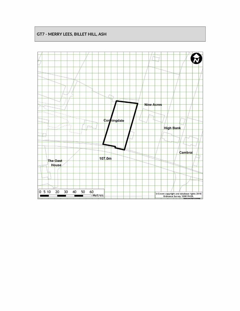
GT7 ‐ MERRY LEES, BILLET HILL, ASH

SITE DELIVERABILITY ASSESSMENT
SHELAA ref GT7 SHELAA category 5 SHELAA conclusion Deliverable SHELAA yield 2 pitches SHELAA density N/A When will development be delivered?
1‐5 years
Will an existing use be lost? If yes, what?
No. Additional pitch on site including 1 temporary pitch
Access requirements Access established. Green Belt strength & boundary issues
Strength: Strong Approx. 950m to settlement green belt boundary
Viability issues No constraints that could render the site financially unviable are identified at this time.
New infrastructure and community benefits
None
Input from technical specialists
N/A
Other considerations None Deliverability summary Orange – due to site being located in the Green Belt, within 1km of
existing settlement and with already existing authorised but temporary pitches
SITE APPRAISAL CONCLUSION Deliverability summary Orange – due to site being located in the Green Belt, within 1km of
existing settlement and with already existing authorised but temporary pitches
Key messages from SA School Health Centre Bus Stop Town/Local Centre
Land Use Gypsy & Traveller Pitches Developable area (ha) 0.14 Density N/A Site capacity 2 pitches Phasing 1‐5 years Overall conclusion
Include in plan
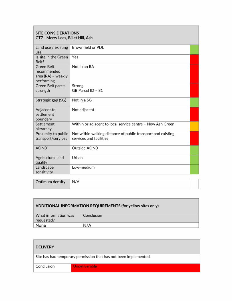
SITE CONSIDERATIONS GT7 ‐ Merry Lees, Billet Hill, Ash Land use / existing use
Brownfield or PDL
Is site in the Green Belt?
Yes
Green Belt recommended area (RA) – weakly performing
Not in an RA
Green Belt parcel strength
Strong GB Parcel ID – 81
Strategic gap (SG) Not in a SG
Adjacent to settlement boundary
Not adjacent
Settlement hierarchy
Within or adjacent to local service centre – New Ash Green
Proximity to public transport/services
Not within walking distance of public transport and existing services and facilities
AONB Outside AONB
Agricultural land quality
Urban
Landscape sensitivity
Low‐medium
Optimum density N/A
ADDITIONAL INFORMATION REQUIREMENTS (for yellow sites only) What information was requested?
Conclusion
None N/A
DELIVERY Site has had temporary permission that has not been implemented. Conclusion Undeliverable

SUMMARY OF CONSULTATION COMMENTS Site promoter No comments received Infrastructure providers No comments received Statutory consultees No comments received Public including Town/Parish Councils
Ash‐cum‐Ridley Parish Council ‐ There is planning permission for a single pitch. A second pitch would result in over intensification of the site and would be out of keeping with the street scene. No special circumstances have been made for the need of a second pitch. There is already a high number of pitches in Ash and the rest of the Parish including the largest County Council managed site in Kent. General public ‐ Already enough pitches within the area Access Infrastructure not adequate Not currently occupied
Other interested parties
No comments received
LOCAL PLAN STRATEGY CONCLUSION Relevant Local Plan strategy Evidence
Gypsy and Traveller – Existing Site The site has not been occupied since the grant of temporary planning permission.
Does this site meet the relevant local plan strategy? NO
OVERALL CONCLUSION Do not include in Plan Land Use Developable area (ha) Density Site capacity
STAGE 2 SITE APPRAISAL CONCLUSION Is this site acceptable for the proposed development? YES

Phasing

GT10 ‐ TWO BARNS, KNATTS LANE, WEST KINGSDOWN

SITE DELIVERABILITY ASSESSMENT
SHELAA ref GT10 SHELAA category 3 SHELAA conclusion Deliverable SHELAA yield 3 pitches SHELAA density N/A When will development be delivered?
1‐5 years
Will an existing use be lost? If yes, what?
No. Additional pitches adjacent to existing permanent pitch.
Access requirements Access onto Knatts Lane. Green Belt strength & boundary issues
Strength: Strong Approx 2km to settlement green belt boundary (via School Lane)
Viability issues No constraints that could render the site financially unviable are identified at this time.
New infrastructure and community benefits
None
Input from technical specialists
Kent Downs AONB Unit
Other considerations New pitches would be in an area of undeveloped land adjacent to the existing pitch within the AONB.
Deliverability summary Orange – due to site being located in the Green Belt and AONB,
further from existing settlement but with already existing authorised pitch.
STAGE 1 SITE APPRAISAL CONCLUSION Deliverability summary Orange – due to site being located in the Green Belt and AONB,
further from existing settlement but with already existing authorised pitch.
Key messages from SA Kent Downs AONB School Health Centre Bus Stop Town/Local Centre
Land Use Gypsy & Traveller Developable area (ha) 0.45 Density N/A Site capacity 3 pitches Phasing 1‐5 years Overall conclusion
Include in plan, subject to further information

SITE CONSIDERATIONS GT10 ‐ Two Barns, Knatts Lane, West Kingsdown Land use / existing use
Brownfield or PDL
Is site in the Green Belt?
Yes
Green Belt recommended area (RA) – weakly performing
Not in an RA
Wider Green Belt parcel strength
Strong GB Parcel ID –78
Strategic gap (SG) Not in a SG
Adjacent to settlement boundary
Not adjacent
Settlement hierarchy
Within or adjacent to lower tier settlement – West Kingsdown
Proximity to public transport/services
Not within walking distance of public transport and existing services and facilities
AONB Fully within AONB
Agricultural land quality
Urban
Landscape sensitivity
Low‐medium
Optimum density N/A
ADDITIONAL INFORMATION REQUIREMENTS (for yellow sites only) What information was requested?
Conclusion
None

SUMMARY OF CONSULTATION COMMENTS Site promoter No comments received Infrastructure providers No comments received Statutory consultees Natural England – Designation Impacted ‐ Kent Downs AONB.
What should be considered for this allocation? ‐ Each policy needs to consider the site’s location within the AONB, ensuring the character of the AONB is protected and enhanced, with reference to the Management Plan, NCA and LCA. Kent Downs AONB Unit ‐ Whilst there is a dispersed settlement pattern in this locality, the proposed allocation is located some distance away from the rural lane network in the open countryside and on the side of a valley. A gypsy site in this location would fail to reflect local settlement pattern and would not conserve nor enhance the AONB. The LCA undertaken by Sevenoaks District Council places this site in the 3b ‘East Hill Wooded Downs’ Landscape Character Area of the Sevenoaks LCA where suburban land uses are noted to detract from the condition of the rural landscape. Local objectives for this area include enhancing local vernacular built form and respecting the special qualities of the Kent Downs AONB. The proposed allocation would not comply with the objectives. The AONB Unit objects to this allocation.
Public including Town/Parish Councils
General Public Comment Summary ‐ There has been a perceived lack of control over unauthorised development which must be addressed. Also, issues regarding AONB must be taken into account.
Other interested parties
CPRE Sevenoaks District Committee ‐ GT10 The site is in the Green Belt and AONB and is accessed via the very steep and winding, single track Knatts Lane. It is remote from the main part of West Kingsdown and schools, shops, public transport and health and social facilities (contrary to Policy 11a).There is no safe and convenient vehicular, pedestrian or cycle access to the site due to the steep, winding, single track nature of Knatts Lane (contrary to Policy 11c)
DELIVERY Site has been promoted by the landowner. Conclusion Deliverable

STAGE 2 SITE APPRAISAL CONCLUSION Is this site acceptable for the proposed development? NO
LOCAL PLAN STRATEGY ASSESSMENT Relevant Local Plan strategy Evidence
Gypsy and Traveller – Existing Site Site has 1 existing permanent pitch
Does this site meet the relevant local plan strategy? YES
OVERALL CONCLUSION Do not include Land Use Developable area (ha) Density Site capacity Phasing
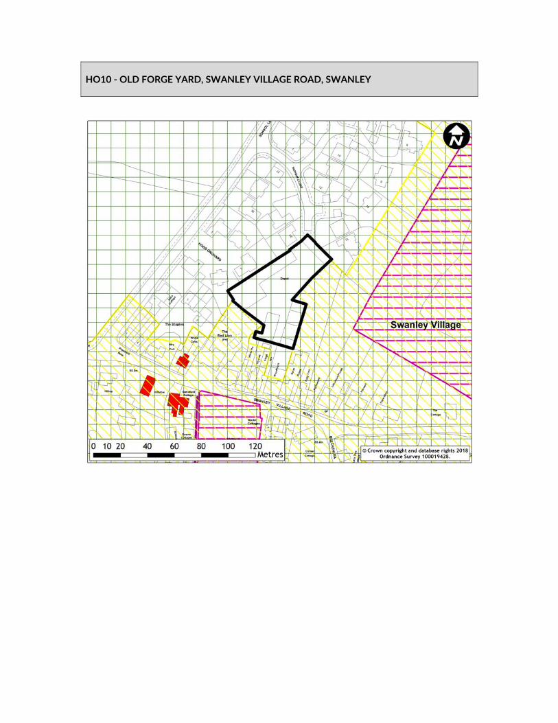
HO10 ‐ OLD FORGE YARD, SWANLEY VILLAGE ROAD, SWANLEY

SITE DELIVERABILITY ASSESSMENT
SHELAA ref HO10 SHELAA category 3 SHELAA conclusion Deliverable SHELAA yield 9‐12 Residential Units SHELAA density 30‐40 DPH When will development be delivered?
1‐5 Years
Will an existing use be lost? If yes, what?
Commercial yard containing a number of buildings/workshops and an area of hardstanding.
Access requirements There is existing access onto Swanley Village Road however this is very narrow and so a new access would be required from either Hoggs Orchard or Hotham Close.
Green Belt strength & boundary issues
Strong
Viability issues Viability may be affected by costs associated with remediating any contamination but at this stage the site is seen as being achievable.
New infrastructure and community benefits
None
Input from technical specialists
Conservation
Other considerations Site area reduced to exclude portion with the Swanley Village Conservation Area. Overall the western part of the site that is previously developed is potentially able to accommodate development. Additional information on site layout and massing is required alongside an assessment of the impact on the conservation area. As the site is in existing employment use it would need to be demonstrated that the use is no longer suitable, feasible or viable and that there is no reasonable prospect of the continued business use in the longer term.
Deliverability summary Yellow – due to site being located in Green Belt and proportion
being NPPF PDL.
STAGE 1 ‐SITE APPRAISAL CONCLUSION
Deliverability summary Yellow – due to site being located in Green Belt and proportion being NPPF PDL.
Key messages from SA Located in conservation area Health centre Bus stop Town/local centre

Land Use Residential Developable area (ha) 0.29 Density Site capacity Phasing 1‐5 Years Overall conclusion
Include in plan, subject to further information
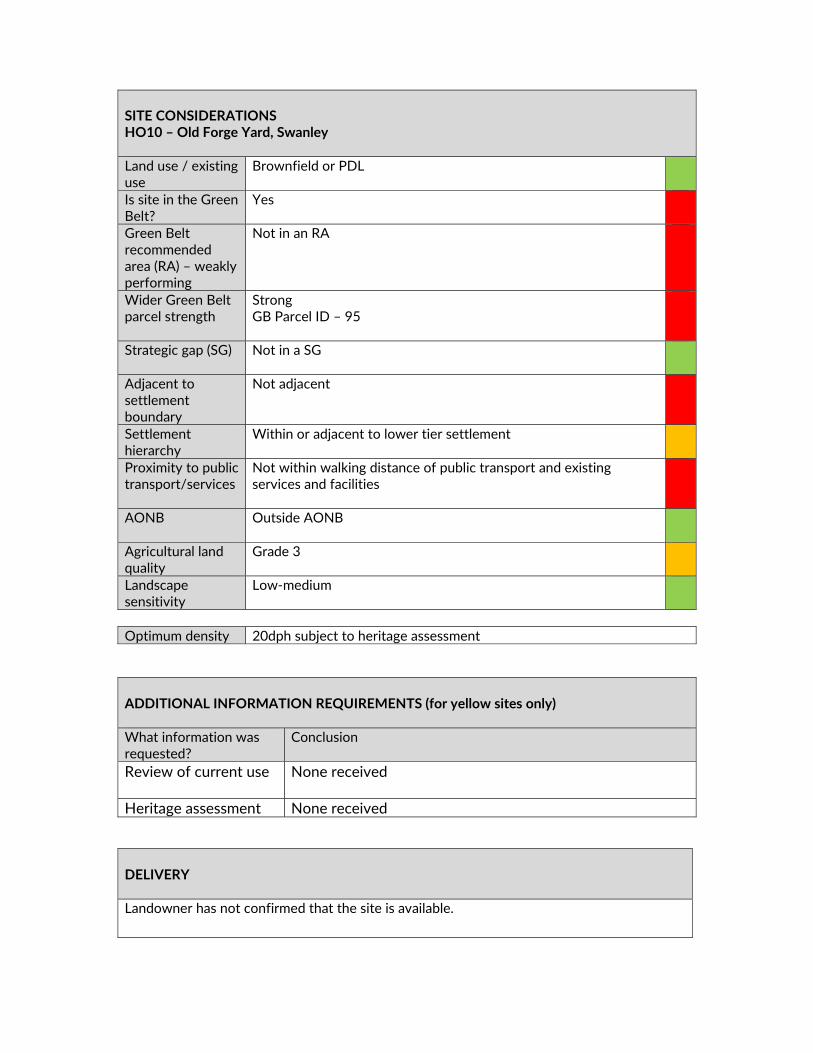
SITE CONSIDERATIONS HO10 – Old Forge Yard, Swanley Land use / existing use
Brownfield or PDL
Is site in the Green Belt?
Yes
Green Belt recommended area (RA) – weakly performing
Not in an RA
Wider Green Belt parcel strength
Strong GB Parcel ID – 95
Strategic gap (SG) Not in a SG
Adjacent to settlement boundary
Not adjacent
Settlement hierarchy
Within or adjacent to lower tier settlement
Proximity to public transport/services
Not within walking distance of public transport and existing services and facilities
AONB Outside AONB
Agricultural land quality
Grade 3
Landscape sensitivity
Low‐medium
Optimum density 20dph subject to heritage assessment
ADDITIONAL INFORMATION REQUIREMENTS (for yellow sites only) What information was requested?
Conclusion
Review of current use
None received
Heritage assessment None received
DELIVERY Landowner has not confirmed that the site is available.

SUMMARY OF CONSULTATION COMMENTS Site promoter No comments received.
Infrastructure providers Kent County Council (KCC) Highways – New access required.
Access ‐ Hotham Close possible? Off School lane Score – C Capacity ‐ Low traffic generation Score ‐ A Sustainability ‐ Primary school. Otherwise Swanley town centre Score – B KCC Primary Education ‐ Up to 1450 new dwellings would generate 406 primary pupils. 406 pupil product is nearly a full 2FE primary school. There is currently some capacity in three of the primary schools in Swanley & Hextable. However, forecasts indicate that this capacity will be largely filled over the next few years. The pupil product from these developments must be accommodated in new provision. Downsview has been mentioned by the developer as the school that could be expanded. The location of much of the new housing would suggest that Downsview is the best option. However, the demand might better be met with a new 2FE primary school. KCC would be happy to talk to the developer and SDC about options for the Swanley Planning Area.
Statutory consultees KCC Heritage and Conservation ‐ Preliminary Heritage Assessment ‐ Broad potential for post medieval remains associated with Red Lion PH, identifiable on 1st Ed OS, and nearby settlement activity. Scale 4 ‐ Low level archaeology anticipated which could be dealt with through suitable conditions on a planning approval.
Public including Town/Parish Councils
Swanley Town Council – No objection. Swanley Town Council has no objection to the development of this site as it is brownfield land. We would suggest access is made through the existing and available access through Hotham Close due to the narrow access on to Swanley Village Road. General Public Comment Summary ‐ There was general agreement that this would be a good use of a brownfield site providing it was a sympathetic development with well planned access. However, the loss of local employment would affect the village and there was some concern over the already congested and dangerous roads become even busier. There is already air pollution in Swanley which would only get worse.
Conclusion Unsuitable
Other interested parties
No comments received.
STAGE 2 SITE APPRAISAL CONCLUSION Is this site acceptable for the proposed development? NO
LOCAL PLAN STRATEGY ASSESSMENT Relevant Local Plan strategy Evidence
Housing – Brownfield in the Green Belt
Previously developed land
Does this site meet the relevant local plan strategy? YES
OVERALL CONCLUSION Do not include Land Use Developable area (ha) Density Site capacity Phasing

HO51 ‐ EUREKA NATURIST CLUB, MANOR LANE, FAWKHAM

SITE DELIVERABILITY ASSESSMENT
SHELAA ref HO51 SHELAA category 3 SHELAA conclusion Deliverable SHELAA yield 6‐8 Residential Units SHELAA density 30‐40 DPH When will development be delivered?
1‐5 Years
Will an existing use be lost? If yes, what?
Naturist retreat containing a single storey permanent building, a number of log cabins and caravans, hardstanding and an open air swimming pool.
Access requirements There is existing access onto Manor Lane however this is a narrow rural lane.
Green Belt strength & boundary issues
Strong Not connected to a settlement
Viability issues No constraints that could render the site financially unviable are identified at this time.
New infrastructure and community benefits
None
Input from technical specialists
Natural England Biodiversity Analysis (subject to NE comments)
Other considerations The site is almost entirely designated as ancient woodland which would require protection and a buffer between the woodland and any future development. Overall the previously developed portion of the site is considered able to accommodate development, subject to the ancient woodland being protected. Site reduced to the previously developed land and locally defined brownfield land only.
Deliverability summary Yellow – due to site being located in Green Belt, proportion being
NPPF PDL and subject to review of the existing use. STAGE 1 ‐ SITE APPRAISAL CONCLUSION Deliverability summary Yellow – due to site being located in Green Belt, proportion being
NPPF PDL and subject to review of the existing use. Key messages from SA High biodiversity
Ancient woodland School Health centre Bus stop Town/local centre

Land Use Residential Developable area (ha) 0.34 Density 40 DPH Site capacity 13 units Phasing 1‐5 Years Overall conclusion
Include in plan, subject to further information
SITE CONSIDERATIONS HO51 ‐ Eureka Naturist Club, Manor Lane, Fawkham Land use / existing use
Brownfield or PDL
Is site in the Green Belt?
Yes
Green Belt recommended area (RA)
Not in an RA
Green Belt parcel strength
Strong GB Parcel ID – 81
Strategic gap (SG) Not in a SG
Adjacent to settlement boundary
Not adjacent
Settlement hierarchy
Not related to a settlement
Proximity to public transport/services
Not within walking distance of public transport and existing services and facilities
AONB Outside AONB
Agricultural land quality
Other land primarily in non agricultural use
Landscape sensitivity
Low‐medium – H1
Optimum density Brownfield site; Not related to settlement – 30DPH
ADDITIONAL INFORMATION REQUIREMENTS (for yellow sites only) What information was requested?
Conclusion
Ecological Survey None submitted
Natural England Response – Ancient Woodland
Ancient woodland is an irreplaceable habitat. Natural England standing advice on ancient woodland states that an appropriate buffer zone of semi‐natural habitat between the development and the ancient woodland should be included (a minimum buffer should be at least 15m). The site cannot accommodate 5 units with a necessary buffer.
STAGE 2 SITE APPRAISAL CONCLUSION Is this site acceptable for the proposed development? NO
SUMMARY OF CONSULTATION COMMENTS Site promoter No comments received.
Infrastructure providers Thames Water ‐ Water Response Not our water area
Waste Response On the information available to date we do not envisage infrastructure concerns regarding wastewater networks in relation to this development/s. Kent County Council (KCC) Highways ‐ No particular concerns subject to level of development proposed. Access would need to be improved. Access ‐ Existing access could be utilised but would need to be improved, Manor Lane is a narrow country lane. Score – B Capacity ‐ A development of this scale would not be likely to lead to any significant impact on capacity. Score ‐ A Sustainability ‐ Remote location. Score – C KCC Primary Education ‐ Up to 942 new dwellings would generate 264 primary pupils. This equates to 1.2FE. There are three schools in the Hartley & New Ash Green planning area. Hartley Academy, Our Lady’s and New Ash Green Primary School. There is one primary school in the impacted part of Sevenoaks Rural North planning area, Fawkham CE PS. There is a small
DELIVERY Site has been promoted by an Agent with support from the landowner. Conclusion Undeliverable

amount of capacity in these four schools, but not enough to accommodate 264 new pupils. This additional demand would require new provision, of between 1 and 1.5 FE.
Statutory consultees KCC Heritage and Conservation ‐ Preliminary Heritage Assessment ‐ Low archaeological potential for as yet unknown archaeology Scale 4 ‐ Low level archaeology anticipated which could be dealt with through suitable conditions on a planning approval.
Public including Town/Parish Councils
Fawkham Parish Council ‐ are open to the possibility of development on this land. The Council supports the proposal that 12 new houses are sustainable in number and could add value to village life. The Council is concerned however, that Manor Lane is very narrow and offers limited access to the proposed site. The Council would want strong assurances from Sevenoaks District Council that, if this proposed development is allowed, there is an agreement that no further development will be permitted on this site. Ash‐cum‐Ridley Parish Council ‐ The protection of the ancient woodland must be ensured. Access is via a single track country lane and there are concerns as to the increased traffic that would be generated by the additional dwellings. General Public Main Issues (in order of frequency)– No building on Green Belt / use brownfield Object to the development Traffic will increase/ safety concerns – dangerous Inadequate infrastructure/ infrastructure must be in place/
bridge not able to cope Access roads to development inadequate Environmental impact/ flora &fauna Support the development Roads already congested Pressure on schools/ doctors/ more needed Area would be spoilt – character./ views/ must be kept a
village/ won’t be in keeping Recognise need for some housing Poor public transport Concerns about flooding/ drainage issues Loss of identity/ urban sprawl Would like the Eureka Naturist Club to go / not happy with it's
current use Pollution will increase / air quality / light / noise / disruption No exceptional circumstances Pressure on utilities / lack of connectivity / pressure on
services Too many houses / no housing needed Lack of amenities/ shops Agricultural land/ farmland Severe parking problems already/ parking would need to be
addressed

Train station parking insufficient/ poor train service
Other interested parties
No comment received.
LOCAL PLAN STRATEGY ASSESSMENT Relevant Local Plan strategy Evidence
Housing – Brownfield in the Green Belt
Previously developed land
Does this site meet the relevant local plan strategy? YES
Do not include in Plan Land Use Developable area (ha) Density Site capacity Phasing

HO77 ‐ MILLVIEW PARK AND FOXLANDS, LONDON ROAD, WEST KINGSDOWN

SITE DELIVERABILITY ASSESSMENT
SHELAA ref HO77 SHELAA category 3 SHELAA conclusion Deliverable SHELAA yield 49‐66 Residential Units SHELAA Density 30‐40 DPH When will development be delivered?
1‐5 Years
Will an existing use be lost? If yes, what?
Residential dwelling and a mobile home park containing approximately 24 mobiles homes.
Access requirements The existing access onto the A20 could be utilised. Green Belt strength & boundary issues
Moderate The site is located adjacent to West Kingsdown urban confines.
Viability issues No constraints that could render the site financially unviable are identified at this time.
New infrastructure and community benefits
None
Input from technical specialists
Kent Downs AONB Unit – No objection
Other considerations Overall the site is considered able to accommodate development. Need to consider loss of 24 mobile home units.
Deliverability summary Yellow – due to site being located in Green Belt, proportion being
NPPF PDL and subject to review of the existing use. STAGE 1 SITE APPRAISAL CONCLUSION Deliverability summary Yellow – due to site being located in Green Belt, proportion being
NPPF PDL and subject to review of the existing use. Key messages from SA Town/local centre Land Use Residential Developable area (ha) 1.66 Density 40 DPH Site capacity 41 units (66 gross) Phasing 1‐5 Years Overall conclusion
Include in plan

SITE CONSIDERATIONS HO77 ‐ Millview Park And Foxlands, London Road, West Kingsdown Land use / existing use
Brownfield or PDL
Is site in the Green Belt?
Yes
Green Belt recommended area (RA) – weakly performing
Not in an RA
Wider Green Belt parcel strength
Moderate GB Parcel ID – 84
Strategic gap (SG) Not in a SG
Adjacent to settlement boundary
Partially adjacent – West Kingsdown
Settlement hierarchy
Within or adjacent to lower tier settlement – West Kingsdown
Proximity to public transport/services
Within walking distance of public transport and existing services and facilities including…
Shops Public Transport
AONB Outside AONB
Agricultural land quality
Urban
Landscape sensitivity
Medium
Optimum density N/A
SUMMARY OF CONSULTATION COMMENTS Site promoter Robinson Escott Planning‐ I am instructed by Mr & Mrs George &
DELIVERY Whilst the landowner has confirmed the site is available, consultation responses from current tenants with long term leases contradicts this. Conclusion Unsuitable

Joyce Sawyer, who is the freehold owner of Millview Mobile Home Park and adjacent dwelling at Foxlands to make following representations of the draft Local Plan. The draft Local Plan proposes that the Millview site should be taken forward as a housing allocation. No additional information is required. The current position is that Mr Sawyer owns a number of the mobile homes on the site but there are also a number of longer term residents with existing leases. In the circumstances, the owner intends to acquire those mobile homes as and when the leases become available. Attached to these representations is a sketch layout which demonstrates how the site might be redeveloped for housing with a total of some 59 units. The scheme would involve a mixture of housing types and sizes including affordable housing in accordance with the requirements set out in the SHMA. The layout demonstrates that a scheme of 59 units can be achieved whilst respecting the spatial standards and context of the site. The site of Foxlands, currently occupied by an existing detached dwelling, is capable of being redeveloped in the short term and the layout also includes a pair of detached houses on this site as part of the overall Masterplan. In the circumstances, it is submitted that this site should be taken forward in the draft Local Plan as a housing allocation. However, in view of the existing tenants and leases on the site and the fact that, in response to the comments that have been already submitted, it is not the intention of the owner to 'evict' any existing resident, the likelihood is that the site would not come forward within the first 5 years of the plan and is more likely to deliver new housing in the second period of 5 ‐ 10 years.
Infrastructure providers Kent County Council (KCC) Highways ‐ Direct access off A20. Junction may require amendment Access – A Capacity –A Sustainability –B
Statutory consultees Thames Water‐ This is currently a residential and caravan park. The majority of the site comprises of grass with caravans situated on top. However, the entire curtilage of the site has been included within the allocation.
Public including Town/Parish Councils
General Public Comment Summary ‐ There was considerable concern about the housing future of the 24 current park home residents. These concerns included the likelihood of getting a fair price to move or offers of relocation. Most of these residents are old retirees who will not have the money to buy new homes while the sale of their park homes would not raise sufficient capital. It would appear that some have not be aware of public meetings to discuss these proposals.
Other interested parties
No comments received

STAGE 2 SITE APPRAISAL CONCLUSION Is this site acceptable for the proposed development? NO
LOCAL PLAN STRATEGY ASSESSMENT Relevant Local Plan strategy Evidence
Housing – Developed land in the Green Belt
Developed land (including previously developed land)
Does this site meet the relevant local plan strategy? YES
OVERALL CONCLUSION Do not include Land Use Developable area (ha) Density Site capacity Phasing

HO104 ‐ BALDWINS YARD, NOAHS ARK, KEMSING
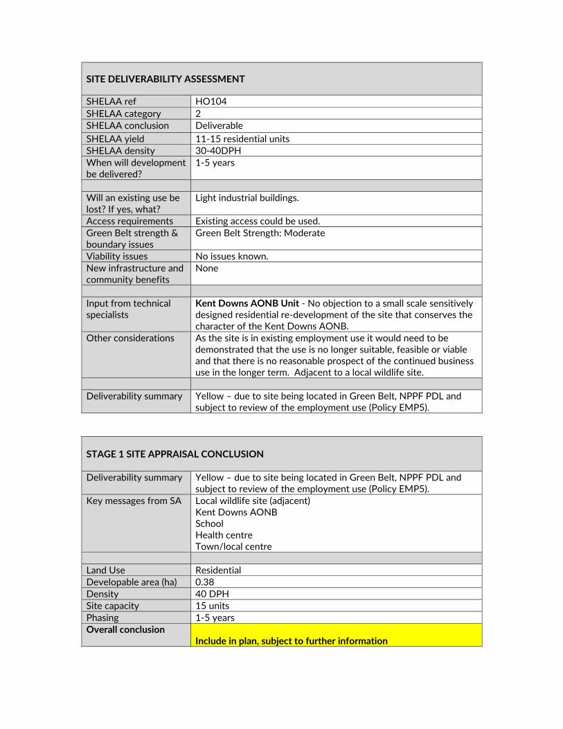
SITE DELIVERABILITY ASSESSMENT
SHELAA ref HO104 SHELAA category 2 SHELAA conclusion Deliverable SHELAA yield 11‐15 residential units SHELAA density 30‐40DPH When will development be delivered?
1‐5 years
Will an existing use be lost? If yes, what?
Light industrial buildings.
Access requirements Existing access could be used. Green Belt strength & boundary issues
Green Belt Strength: Moderate
Viability issues No issues known. New infrastructure and community benefits
None
Input from technical specialists
Kent Downs AONB Unit ‐ No objection to a small scale sensitively designed residential re‐development of the site that conserves the character of the Kent Downs AONB.
Other considerations As the site is in existing employment use it would need to be demonstrated that the use is no longer suitable, feasible or viable and that there is no reasonable prospect of the continued business use in the longer term. Adjacent to a local wildlife site.
Deliverability summary Yellow – due to site being located in Green Belt, NPPF PDL and
subject to review of the employment use (Policy EMP5). STAGE 1 SITE APPRAISAL CONCLUSION Deliverability summary Yellow – due to site being located in Green Belt, NPPF PDL and
subject to review of the employment use (Policy EMP5). Key messages from SA Local wildlife site (adjacent)
Kent Downs AONB School Health centre Town/local centre
Land Use Residential Developable area (ha) 0.38 Density 40 DPH Site capacity 15 units Phasing 1‐5 years Overall conclusion
Include in plan, subject to further information
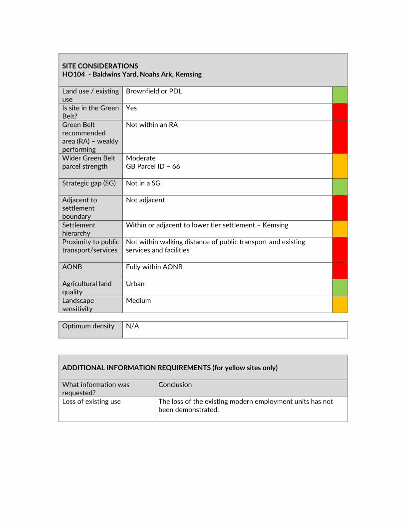
SITE CONSIDERATIONS HO104 ‐ Baldwins Yard, Noahs Ark, Kemsing Land use / existing use
Brownfield or PDL
Is site in the Green Belt?
Yes
Green Belt recommended area (RA) – weakly performing
Not within an RA
Wider Green Belt parcel strength
Moderate GB Parcel ID – 66
Strategic gap (SG) Not in a SG
Adjacent to settlement boundary
Not adjacent
Settlement hierarchy
Within or adjacent to lower tier settlement – Kemsing
Proximity to public transport/services
Not within walking distance of public transport and existing services and facilities
AONB Fully within AONB
Agricultural land quality
Urban
Landscape sensitivity
Medium
Optimum density N/A
ADDITIONAL INFORMATION REQUIREMENTS (for yellow sites only) What information was requested?
Conclusion
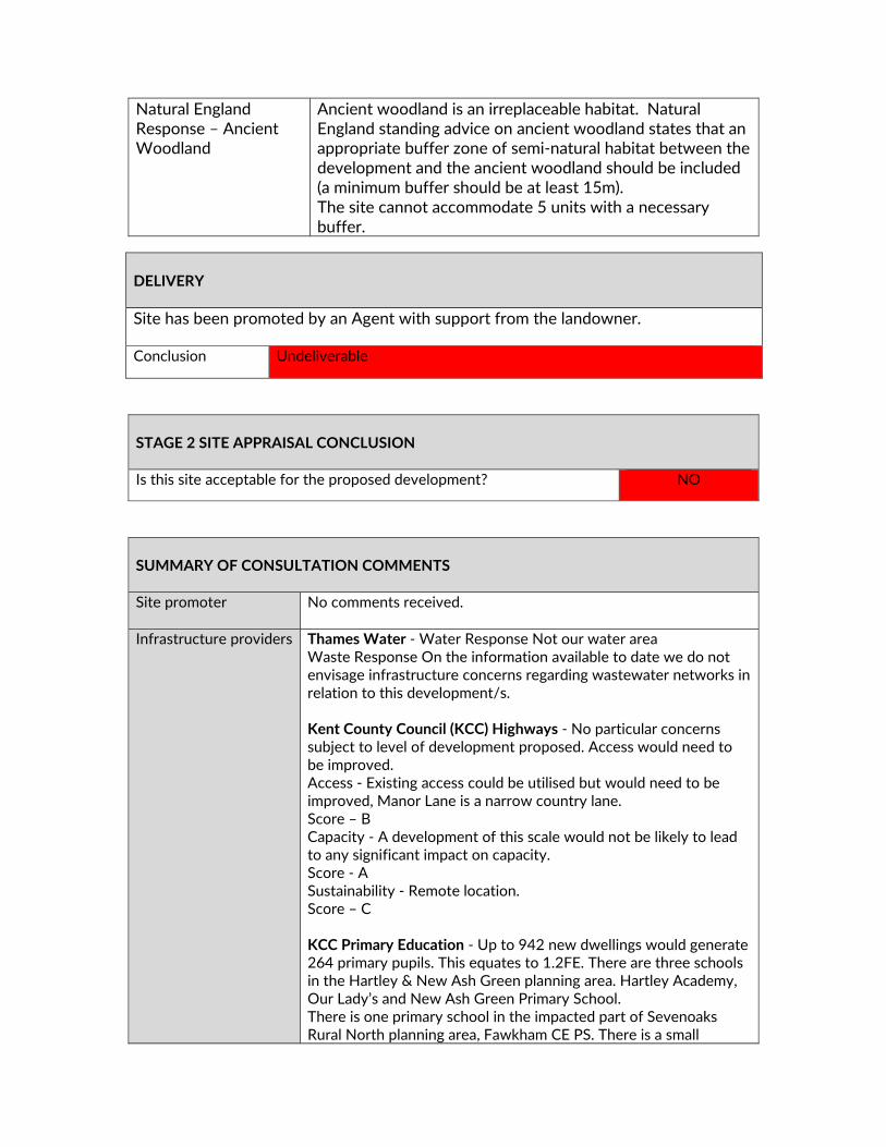
Loss of existing use The loss of the existing modern employment units has not been demonstrated.
SUMMARY OF CONSULTATION COMMENTS Site promoter DHA Planning – Support inclusion of the site.
Infrastructure providers Kent County Council (KCC) Highways ‐ Existing access could be
utilised Access – A Capacity – A Sustainability –C
Statutory consultees Kent Downs AONB Unit ‐ No objection given the brownfield nature of the site, presence of large industrial style buildings on the site and location within an existing settlement. It will be important to ensure existing trees around the perimeter of the site are retained and protected, development is designed and laid out in such a way as to conserve the character of the Kent Downs AONB and development is restricted to a maximum of two stories in height to reflect existing development in the locality Natural England – Designation Impacted ‐ Kent Downs AONB. What should be considered for this allocation? ‐ Each policy needs to consider the site’s location within the AONB, ensuring the character of the AONB is protected and enhanced, with reference to the Management Plan, NCA and LCA. Thames Water‐ Water Response Not our water area Waste Response On the information available to date we do not envisage infrastructure concerns regarding wastewater networks in relation to this development/s. It is recommended that the Developer and the Local Planning Authority liaise with Thames Water at the earliest opportunity to advise of the developments phasing. NHS West Kent CCG‐ Having assessed the proposed developments detailed under the other settlements part of the draft local plan a significant impact has emerged relating to Otford Medical Practice. Not taking into account the sites that need to be confirmed, the impact of the ‘other settlements’ would be growth of c. 1650 new patient registrations (Using average occupancy of 2.34 per dwelling). There is an existing pressure on services ‐ Otford Medical Practice have plans to reconfigure the main surgery
DELIVERY The loss of the existing high quality modern employment units has not been demonstrated. Site could come forward through the development management process for redevelopment. Conclusion Unsuitable

at Otford and have developed plans to extend the branch surgery at Kemsing for which capital is currently being explored. This will not however support all of the growth set out above and further discussions will be required as part of the CCG strategic planning work and the Local Plan infrastructure delivery plan. KCC Heritage and Conservation ‐ Preliminary Heritage Assessment ‐ Archaeological potential for remains associated with prehistoric activity due to river valley to the south. Potential for post medieval remains associated with Noah’s Ark, 17th century cottage pair. Noah’s Ark is Grade II listed building. Heritage Statement required to support any application, including consideration of impact on the designated Noah’s Ark. Scale 3 ‐ Significant archaeology could be dealt with through suitable conditions on a planning approval.
Public including Town/Parish Councils
General Public Comment Summary ‐ There was general agreement that this would be a good use of a brownfield site providing it was a sympathetic development to ensure the retention of the AONB and with well‐planned access. Concern was expressed about the increased pressure on Otford Medical Practice.
Other interested parties
No comments received
STAGE 2 SITE APPRAISAL CONCLUSION Is this site acceptable for the proposed development? NO
LOCAL PLAN STRATEGY ASSESSMENT Relevant Local Plan strategy Evidence
Housing – Developed land in the Green Belt
Previously developed land – high quality existing employment buildings on site
Does this site meet the relevant local plan strategy? YES
OVERALL CONCLUSION Do not include

Land Use Developable area (ha) Density Site capacity Phasing

HO371/HO372/HO373/HO374/EM17 – WHICH WAY WESTERHAM

SITE DELIVERABILITY ASSESSMENT
Site reference HO371 / HO372 / HO373 / HO374 / EM17 Site address Land south of Farley Lane, Westerham HO371 &
Land north of Farley Lane, Westerham HO372 & Land east of Croydon Road, Westerham HO373 & Land south of Madan Road, Westerham HO374 & Land south of Beggars Lane, Westerham EM17
SHELAA category 4 SHELAA conclusion Deliverable SHELAA yield 25‐34 residential units (HO371) &
87‐116 residential units (HO372) & 164‐218 residential units (HO373) & 329‐439 residential units (HO374) & B1‐B8 floorspace
Density 30‐40 DPH When will development be delivered?
1‐5 years
Will an existing use be lost? If yes, what?
Agricultural fields
Access requirements New access points will be required
Green Belt strength & boundary issues
Moderate. Adjacent to edge of settlement Partially within weak performing green belt RA7 & RA9
Viability issues None identified New infrastructure and community benefits
A25 Relief Road Common Land extensions (25 ha) Environmental improvements, landscape restoration and flood risk management works (25 ha) Employment space Environmental landform screen to M25 – noise, light and air pollution attenuation plus renewable energy generation and storage Contributions/facilities for GP surgery and primary school, including second school access road Contributions for public realm and parking works in the town centre
Input from technical specialists
Kent Downs AONB Unit ‐ The AONB Unit has expressed strong objections to a major development in the AONB which would be contrary to paragraph 116 of the NPPF and proposed revised draft NPPF which advises new development in AONBs should be limited in scale. Environmental Health KCC Highways Natural England Highways England (due to M25)
Other considerations Site of Special Scientific Interest Impact risk zone for residential units.

Deliverability summary Yellow – provision of infrastructure benefits and includes
weakly/moderate/strongly performing green belt. STAGE 1 SITE APPRAISAL CONCLUSION Deliverability summary Yellow – provision of infrastructure benefits and includes
weakly/moderate/strongly performing green belt. Key messages from SA Kent Downs AONB
AQMA (HO374, EM17) SSSI Impact Risk Zone School Health centre Bus stop Town/local centre
Land Use Mixed Use – Residential, Employment, Community, Infrastructure Developable area (ha) 21.75 Density 40DPH Site capacity 600 Phasing 1‐5 years, 6‐10 years, 11‐15 years Overall conclusion
Include in plan, subject to further information

SITE CONSIDERATIONS HO371, HO372, HO373, HO374 and EM17 ‐ Land North And East Of Westerham Land use / existing use
Agricultural land / natural field
Is site in the Green Belt?
Yes
Green Belt recommended area (RA) – Weakly Performing
Partially within an RA (97.2 %) RA‐9 / RA‐7
Wider Green Belt parcel strength
HO373, HO373 + EM17 Strong HO372 + HO771 – Moderate
Strategic gap (SG) Near a SG Westerham ‐ Brasted
Adjacent to settlement boundary
Partially adjacent – Westerham
Settlement hierarchy
Within or adjacent to top‐tier settlement (4 towns) –Westerham
Proximity to public transport/services
Within walking distance of public transport and existing services and facilities including… Bus Stop – 23m (HO372) – 523m (HO374) Train Station – Not within walking distance (6974m – HO374)
AONB Fully within AONB
Agricultural land quality
Grade 3
Landscape sensitivity
Medium – Residential and Commercial Development
Optimum density Edge of settlement (average 40DPH) Density will vary across sites,
making efficient use of land and respecting the character of the location, and will be developed through further site design and assessment. It is anticipated that the centre of the sites will be of higher density and the edge of the sites will be lower density, forming a softer graduated edge to the development.

ADDITIONAL INFORMATION REQUIREMENTS (for yellow sites only) What information was requested?
Conclusion
Social and community infrastructure evidence
See the infrastructure table.
West Kent CCG – Health hub supported
It has not been demonstrated that there is an existing need for new health facilities.
Education provider’s response – facilities supported
It has been demonstrated that the expansion of existing education facilities is supported.
Transport modelling A Transport Statement and transport model has been provided
Indicative layout plan An indicative layout plan has been provided. Ecology + landscape assessment required (including impact on AONB)
It has not been demonstrated that the benefits of the development outweighs the harm to the AONB.
DELIVERY Single landowner across all sites with long‐term interest in area Site has been promoted by Agent with support from the landowner The site promoter has provided an indicative phasing plan Site promotion team appointed and supporting studies provided / in preparation Conclusion Developable
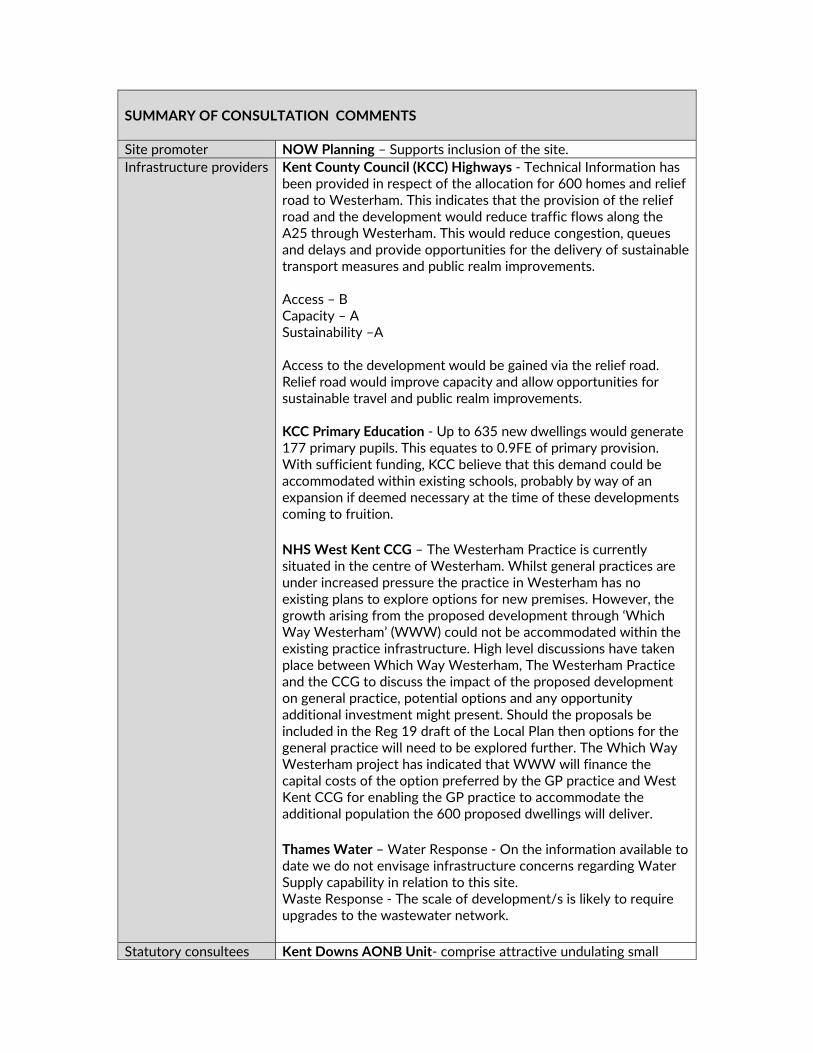
SUMMARY OF CONSULTATION COMMENTS Site promoter NOW Planning – Supports inclusion of the site. Infrastructure providers Kent County Council (KCC) Highways ‐ Technical Information has
been provided in respect of the allocation for 600 homes and relief road to Westerham. This indicates that the provision of the relief road and the development would reduce traffic flows along the A25 through Westerham. This would reduce congestion, queues and delays and provide opportunities for the delivery of sustainable transport measures and public realm improvements. Access – B Capacity – A Sustainability –A Access to the development would be gained via the relief road. Relief road would improve capacity and allow opportunities for sustainable travel and public realm improvements. KCC Primary Education ‐ Up to 635 new dwellings would generate 177 primary pupils. This equates to 0.9FE of primary provision. With sufficient funding, KCC believe that this demand could be accommodated within existing schools, probably by way of an expansion if deemed necessary at the time of these developments coming to fruition. NHS West Kent CCG – The Westerham Practice is currently situated in the centre of Westerham. Whilst general practices are under increased pressure the practice in Westerham has no existing plans to explore options for new premises. However, the growth arising from the proposed development through ‘Which Way Westerham’ (WWW) could not be accommodated within the existing practice infrastructure. High level discussions have taken place between Which Way Westerham, The Westerham Practice and the CCG to discuss the impact of the proposed development on general practice, potential options and any opportunity additional investment might present. Should the proposals be included in the Reg 19 draft of the Local Plan then options for the general practice will need to be explored further. The Which Way Westerham project has indicated that WWW will finance the capital costs of the option preferred by the GP practice and West Kent CCG for enabling the GP practice to accommodate the additional population the 600 proposed dwellings will deliver. Thames Water – Water Response ‐ On the information available to date we do not envisage infrastructure concerns regarding Water Supply capability in relation to this site. Waste Response ‐ The scale of development/s is likely to require upgrades to the wastewater network.
Statutory consultees Kent Downs AONB Unit‐ comprise attractive undulating small

scale pastures enclosed by hedges with an intact pattern of field boundaries and as such are considered to be of particularly high sensitivity as recognised in the LSS. Furthermore the proposals would be in conflict with the objectives of the Sevenoaks LCA which includes retaining historic land use patterns and conserving the remnant small pastures in the valley bottom. While the boundaries of the fields might not be compromised, the character of the fields would be wholly compromised. Natural England‐ Designation Impacted ‐ Kent Down AONB, Westerham Woods SSS Westerham Mines. What should be considered for this allocation? This allocation directly contradicts the aims of the AONB Management Plan, and prevents enhancement and protection of the AONB. All allocations for major development within the AONB need to be robustly assessed against the three tests in the NPPF(paragraph 171).The site is within the Impact Risk Zone (IRZ) for the SSSI. Westerham Mines is an important autumn swarming site for bats in addition to being a key hibernation site. If these sites are allocated, a coherent green infrastructure network linking the site with the surrounding habitats and landscape will be important to facilitate movement of wildlife, help with climate change, provide corridors for movement, and contribute to the human health and wellbeing benefits that access to green space can bring. Due to the rural location and the scale of the allocation, we are extremely concerned about the landscape impact of this proposal on the AONB and the direct loss of AONB features. Subject to assessment against the three tests, Natural England objects to this allocation. KCC SuDS ‐ The submission for the proposed development recognises the local flooding and drainage issues within the locality and offers inclusion of a strategic provision for the area within the development proposal. The different sites have different underlying geology and infiltration potential. It is assumed that attenuation will be a significant requirement across the sites but this may be included with the strategic provision offered for consideration. Assessment will be required on a strategic level given the spread of the site. Space for attenuation of surface water will need to be included within the layout. KCC Heritage and Conservation – (HO371/372) Scale 4 ‐ Low level archaeology anticipated which could be dealt with through suitable conditions on a planning approval. (HO373) Significant archaeology could be dealt with through suitable conditions on a planning approval. (HO374) Pre‐determination assessment should be carried out to clarify whether development of any part of the site is possible.
Public including Town/Parish Councils
Bromley Borough Council – Concerns that the increase in the need for public transport and construction traffic would have negative impacts on the transport network in Bromley.

Westerham Town Council – WTC strongly objects to the Squerryes proposal contained in “Which Way Westerham”(WWW). It submits that the proposal fails to meet either the public interest test for development within the nationally important landscape of the Kent Downs AONB or the requirements for the very high bar set for exceptional circumstances sites and that it should therefore not proceed to the final draft of the Local Plan to be submitted to the Planning Inspectorate. The ‘benefits’ put forward accommodate the new development and not an existing need. General Public Main Issues (in order of frequency)–
Object to development No building on green belt / AONB / SSSI / use brownfield Too many houses / no housing needed Traffic will increase Westerham does not need a bypass / relief road Area would be spoiled ‐ character / views Pollution will increase / air quality Poor public transport Pressure on schools/ doctors/ more needed Disagree with moving doctors surgery Disruption/ noise from construction Concerned about flooding Environmental Impact/ flora & fauna Inadequate infrastructure/ infrastructure must be in place Access roads to developments inadequate No exceptional circumstances Severe parking problems Roads already congested No job/ employment opportunities Recognise needs for some housing No need for industrial estate Affordable housing must be provided Lake of amenities/ shops Community spirit will disappear Increase in crime/ anti‐social behaviour
Other interested parties
CPRE Kent (Sevenoaks District Committee) – We cannot support these proposals because the harm they would cause to the openness of the Green Belt and the landscape of AONB do not outweigh the claimed advantages.
INFRASTRUCTURE CONSIDERATIONS (for greenfield + green belt sites only) What Infrastructure is proposed? (updated to incorporate Draft Local Plan representations from site promoter)
Does it meet an evidenced existing need?
Relief Road KCC supportive of proposals but not a priority – not an existing ‘evidenced need’
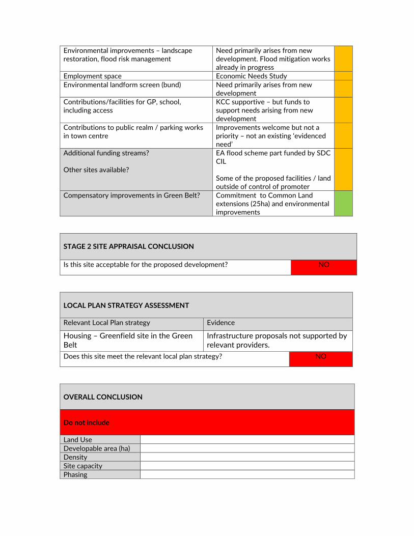
Environmental improvements – landscape restoration, flood risk management
Need primarily arises from new development. Flood mitigation works already in progress
Employment space Economic Needs Study Environmental landform screen (bund) Need primarily arises from new
development
Contributions/facilities for GP, school, including access
KCC supportive – but funds to support needs arising from new development
Contributions to public realm / parking works in town centre
Improvements welcome but not a priority – not an existing ‘evidenced need’
Additional funding streams? Other sites available?
EA flood scheme part funded by SDC CIL Some of the proposed facilities / land outside of control of promoter
Compensatory improvements in Green Belt?
Commitment to Common Land extensions (25ha) and environmental improvements
STAGE 2 SITE APPRAISAL CONCLUSION Is this site acceptable for the proposed development? NO
LOCAL PLAN STRATEGY ASSESSMENT Relevant Local Plan strategy Evidence
Housing – Greenfield site in the Green Belt
Infrastructure proposals not supported by relevant providers.
Does this site meet the relevant local plan strategy? NO
OVERALL CONCLUSION Do not include Land Use Developable area (ha) Density Site capacity Phasing


MX10 ‐ LAND AT BREEZEHURST FARM, CROUCH HOUSE ROAD, EDENBRIDGE
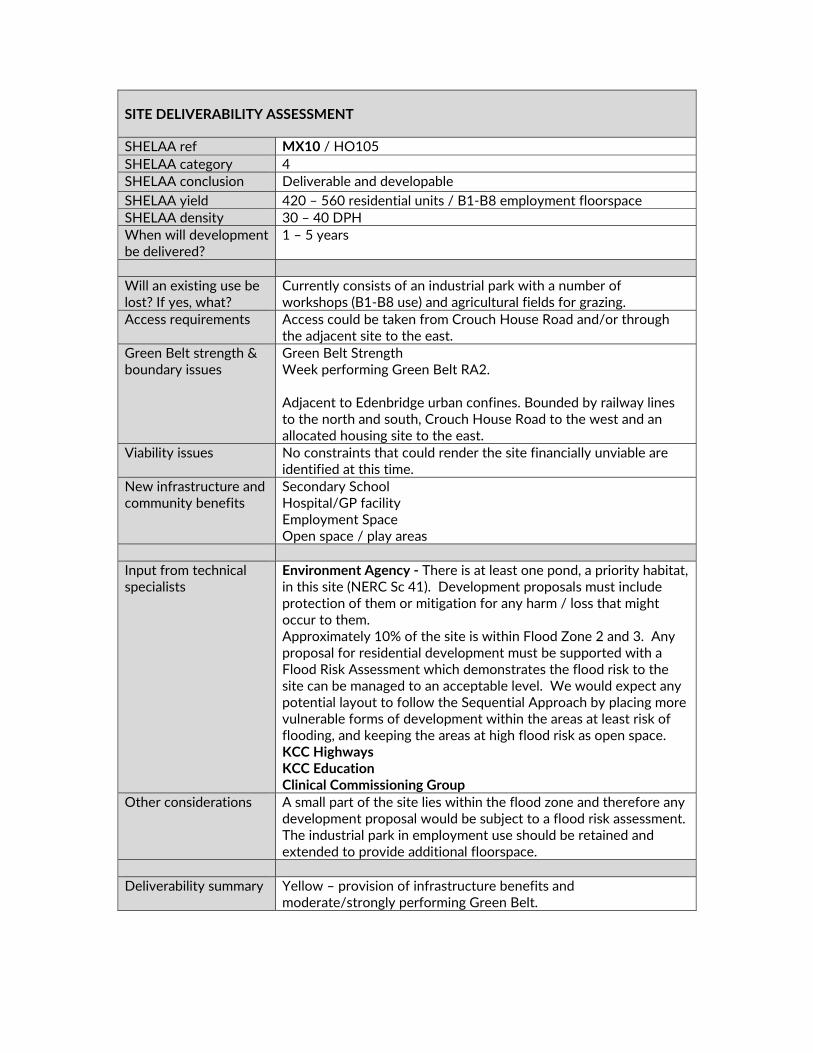
SITE DELIVERABILITY ASSESSMENT
SHELAA ref MX10 / HO105 SHELAA category 4 SHELAA conclusion Deliverable and developable SHELAA yield 420 – 560 residential units / B1‐B8 employment floorspace SHELAA density 30 – 40 DPH When will development be delivered?
1 – 5 years
Will an existing use be lost? If yes, what?
Currently consists of an industrial park with a number of workshops (B1‐B8 use) and agricultural fields for grazing.
Access requirements Access could be taken from Crouch House Road and/or through the adjacent site to the east.
Green Belt strength & boundary issues
Green Belt Strength Week performing Green Belt RA2. Adjacent to Edenbridge urban confines. Bounded by railway lines to the north and south, Crouch House Road to the west and an allocated housing site to the east.
Viability issues No constraints that could render the site financially unviable are identified at this time.
New infrastructure and community benefits
Secondary School Hospital/GP facility Employment Space Open space / play areas
Input from technical specialists
Environment Agency ‐ There is at least one pond, a priority habitat, in this site (NERC Sc 41). Development proposals must include protection of them or mitigation for any harm / loss that might occur to them. Approximately 10% of the site is within Flood Zone 2 and 3. Any proposal for residential development must be supported with a Flood Risk Assessment which demonstrates the flood risk to the site can be managed to an acceptable level. We would expect any potential layout to follow the Sequential Approach by placing more vulnerable forms of development within the areas at least risk of flooding, and keeping the areas at high flood risk as open space. KCC Highways KCC Education Clinical Commissioning Group
Other considerations A small part of the site lies within the flood zone and therefore any development proposal would be subject to a flood risk assessment. The industrial park in employment use should be retained and extended to provide additional floorspace.
Deliverability summary Yellow – provision of infrastructure benefits and
moderate/strongly performing Green Belt.

STAGE 1 SITE APPRAISAL CONCLUSION Deliverability summary Yellow – provision of infrastructure benefits and
moderate/strongly performing Green Belt. Key messages from SA School
Health centre Town/local centre
Land Use Mixed Use – Residential, Employment, Secondary School, Health
Hub Developable area (ha) 18.0 Density 40DPH Site capacity 450 Phasing 1‐5 years & 6‐10 years Overall conclusion
Include in plan, subject to further information
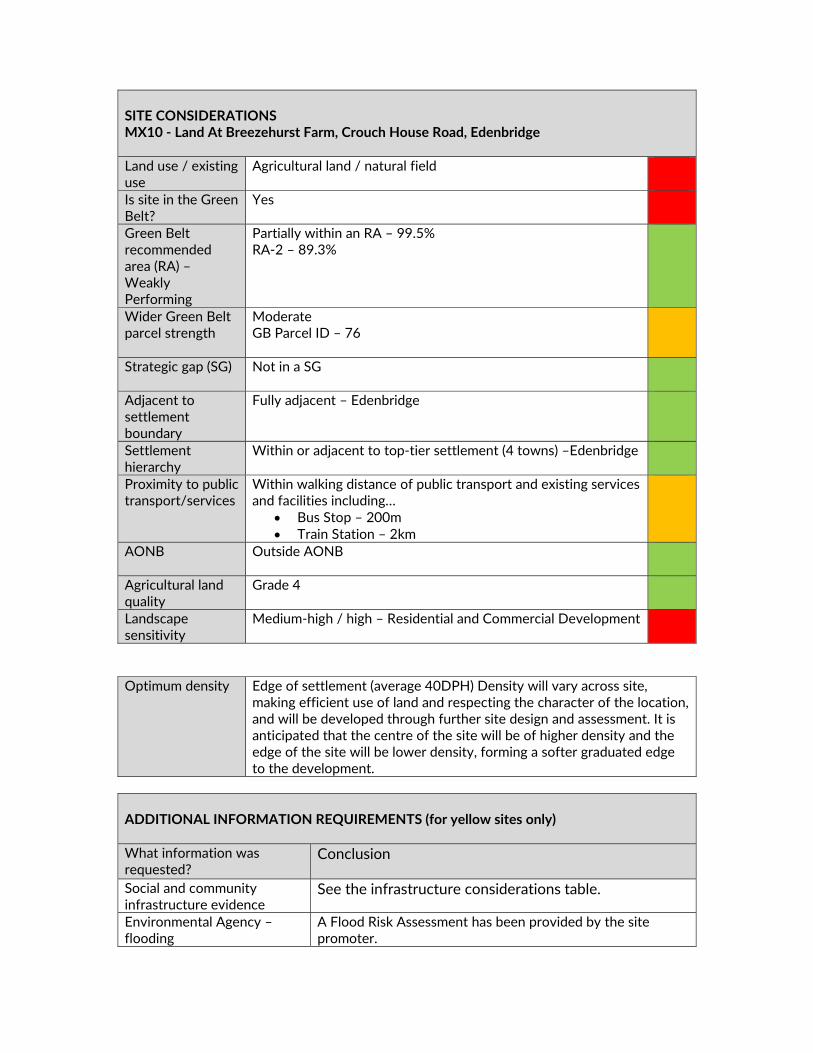
SITE CONSIDERATIONS MX10 ‐ Land At Breezehurst Farm, Crouch House Road, Edenbridge Land use / existing use
Agricultural land / natural field
Is site in the Green Belt?
Yes
Green Belt recommended area (RA) – Weakly Performing
Partially within an RA – 99.5% RA‐2 – 89.3%
Wider Green Belt parcel strength
Moderate GB Parcel ID – 76
Strategic gap (SG) Not in a SG
Adjacent to settlement boundary
Fully adjacent – Edenbridge
Settlement hierarchy
Within or adjacent to top‐tier settlement (4 towns) –Edenbridge
Proximity to public transport/services
Within walking distance of public transport and existing services and facilities including…
Bus Stop – 200m Train Station – 2km
AONB Outside AONB
Agricultural land quality
Grade 4
Landscape sensitivity
Medium‐high / high – Residential and Commercial Development
Optimum density Edge of settlement (average 40DPH) Density will vary across site,
making efficient use of land and respecting the character of the location, and will be developed through further site design and assessment. It is anticipated that the centre of the site will be of higher density and the edge of the site will be lower density, forming a softer graduated edge to the development.
ADDITIONAL INFORMATION REQUIREMENTS (for yellow sites only) What information was requested?
Conclusion
Social and community infrastructure evidence
See the infrastructure considerations table.
Environmental Agency –flooding
A Flood Risk Assessment has been provided by the site promoter.

West Kent CCG – Health hub supported
It is demonstrated that the provision of a new health facility in Edenbridge is supported.
KCC Highways response – sufficient capacity
It is demonstrated that that there is insufficient capacity on the highway network.
Transport modelling A Transport Statement has been provided. Indicative layout plan A indicative layout plan has been provided. Ecology and landscape assessment
A preliminary ecological assessment and landscape appraisal has been provided.
SUMMARY OF CONSULTATION COMMENTS Site promoter Lee Evans Partnership LLP – The Breezehurst Farm site should be
allocated for development in order to assist with meeting Sevenoaks District Council’s housing requirements for the Local Plan period 2015‐2035 and conclude the following: • The Local Plan does not provide sufficient housing land to meet the level of new housing that is required for the District and thus there would be a shortfall of at least approximately 560 dwellings based on the Council’s preferred approach; • Based on the Council’s Settlement Hierarchy, which classifies Edenbridge as second‐tier “Town”, and demonstrates that is scores highly in terms of the size of the existing settlement, the amount of existing services and facilities available and transport links, Edenbridge should be considered for a greater quantum of development than currently proposed; • As demonstrated by the Council’s Evidence Base, Breezehurst Farm is the most suitable site for Green Belt release and site allocation of those sites adjoining Edenbridge; • Development of the site would represent a logical extension of the existing settlement; • That Breezehurst Farm would have sufficient capacity to provide the required Health Hub and new Secondary School, as well as providing additional employment floorspace, demonstrating ‘Exceptional Circumstances’ through the provision of social and community infrastructure. • Whether Sevenoaks District Council considers there to be a requirement for ‘Exceptional Circumstances’ or not, in the case of
DELIVERY Site has been promoted by Agent with support from the landowner The site promoter has indicated that there are no physical or viability constraints that would prevent the site commencing within years 1‐5 Site promotion team appointed and supporting studies provided / in preparation Conclusion Deliverable / Developable

the representation site, Breezehurst Farm should still be brought forward for allocation as a sustainable location for development.
Infrastructure providers Kent County Council (KCC) Highways ‐Proposed medical centre to the north of Breezhurst Farm with access approximately 40 metres from where road bend to Little Browns Lane. Potential visibility issues. Second access to the south of mobile home site. Full TA required to enable full assessment. Access‐ A Capacity –B Sustainability – A Edenbridge is located in a rural area without the benefit of high quality principle roads. It is accessed via B roads to the north and to the east and a ‘c class’ road (Lingfield Road) to the west. These roads are single carriageway with constraints along their routes including villages, bends and narrowings. There are no obvious improvements to bring these routes up to a principal route status. Development which leads to any significant increase in traffic movements is likely to lead to traffic issues along these routes. Edenbridge does however benefit from 2 rail stations providing links between Uckfield/London and Redhill and Tonbridge. Kent County Council Highways – I have considered the Highways Feasibility Report dated August 2018prepared by Mayer Brown. The existing highway network leading to this site is constrained in terms of width with pinch points at the railway bridges and lacking in pedestrian facilities. The level of development proposed would add significantly to the traffic on these routes causing congestion and safety issues. I am not satisfied that safe and suitable access to the site can be achieved for all people, that opportunities for sustainable transport modes can be provided or that the mitigating measures proposed are sufficient to address the concerns raised or indeed deliverable. I would recommend that these matters be addressed in a Transport Assessment in order that further consideration can be given. KCC Secondary Education ‐ Many people from Edenbridge have wanted a secondary school since the closure of Eden Valley School in 2002. KCC offers no opposition to this aspiration, but any new school must be viable. The existing secondary demand, added to the additional demand created if ALL the Edenbridge sites are developed would still only create about 4FE. This is because many Edenbridge students would still prefer to attend Grammar or faith schools in Tonbridge or Tunbridge Wells. A point of support would be available if the school was located in the north of the town, so making it more accessible for students from Westerham. A 4FE secondary school in Edenbridge could be vulnerable financially, but if such a school can be proven to be part of the whole secondary solution for Sevenoaks, KCC would of course,
give it serious consideration. KCC Primary Education ‐ There is currently sufficient capacity at Edenbridge Primary School to accommodate about 100‐150 additional primary pupils across all seven‐year groups. If all options are progressed, an additional 1FE would be required. Edenbridge Primary School was enlarged two years ago and cannot be enlarged again. The two other primary schools in the planning area (Four Elms PS and Hever CE PS) have small sites and do not lend themselves to enlargement. If the demand increases beyond that forecast, Edenbridge Town will need a new 1FE Primary school built in or near the town. NHS West Kent CCG ‐ There is an existing need in Edenbridge and a new combined hospital and GP surgery in Edenbridge has been agreed following public consultation in 2017. The CCG can therefore confirm that the provision of a health facility in this area is supported and work is underway to determine the preferred site. Using the average occupancy figure of 2.34 per dwelling the growth in Edenbridge is expected to be c. 3000 new patient registrations; the project would allow for the proposed growth arising from the local plan to be accommodated. The CCG, Kent Community Health NHS Foundation Trust and Edenbridge Medical Practice have indicated that developer contributions will be sought through CIL as a contribution towards the new infrastructure.
Statutory consultees KCC SuDS ‐ The site is traversed by an area of fluvial flood risk and some associated extent of surface water overland flow paths. The areas of flood risk will need to be assessed and avoided. SuDS features should not be located within any area of flood risk. Space for attenuation of surface water will need to be included within the layout. KCC Heritage and Conservation ‐ Scale 4 ‐ Low level archaeology anticipated which could be dealt with through suitable conditions on a planning approval.
Public including Town/Parish Councils
Edenbridge Town Council – If members’ proposals are accepted for the relocation of the medical facility and school on the Four Elms Road site, but the land to the south east of HO189 is unavailable, Edenbridge Town Council proposes the possibility of an arrangement to enable some housing development on the Breezehurst Farm site. Members preference is as proposed under land south and east of Four Elms Road HO189, HO190, HO223, MX25, MX26. If this site goes ahead members request a feathering and stepping of buildings to protect the Green Belt. Hever Parish Council ‐ Members believe that this site on the Western / Southern side of Edenbridge is too remote for a health / education site with inadequate highway / public transport provision, especially for residents of villages such as Hever, Four Elms and surrounds. Even with the developers proposed traffic
lights by the railway bridge on Crouch House road, there are a number of pinch points from the main routes in Edenbridge compounded by residents having to park on the roads, which would cause regular gridlock. General Public Main Issues (in order of frequency)–
Access road to developments inadequate Traffic will increase Disagree with out of town location for medical centre Object to development No building on Green Belt/ use brownfield Inadequate infrastructure/ infrastructure must be in place Support the development Pressure on schools/ doctors/ more needed Poor public transport Too many houses/ no housing needed Train station parking insufficient/ poor train service Lack of amenities/ shops Environmental impact/ flora & fauna Recognise need for some housing Roads already congested Concerns about flooding Area would be spoiled – character/ views
Other interested parties
CPRE Kent (Sevenoaks District Committee) – MX10: The site should be removed from Plan as it is too far from the town for medical centre/school.
INFRASTRUCTURE CONSIDERATIONS (for greenfield + green belt sites only) What Infrastructure is proposed? (updated to incorporate Draft Local Plan representations from site promoter)
Does it meet an evidenced existing need?
Land for primary care / GP facility CCG – but this is not the CCG preferred location for this facility Draft Neighbourhood Plan identifies need for health facility
Secondary School Draft Neighbourhood Plan identifies need for senior education facility
Employment Space Economic Needs Study Additional funding streams? Other sites available?
Not identified Four Elms Road
Compensatory improvements in Green Belt?
Open space, play areas
STAGE 2 SITE APPRAISAL CONCLUSION Is this site acceptable for the proposed development? YES
LOCAL PLAN STRATEGY ASSESSMENT Relevant Local Plan strategy Evidence
Housing – Greenfield site in the Green Belt
Infrastructure proposals not supported by relevant providers.
Does this site meet the relevant local plan strategy? No
OVERALL CONCLUSION Do not include Land Use Developable area (ha) Density Site capacity Phasing
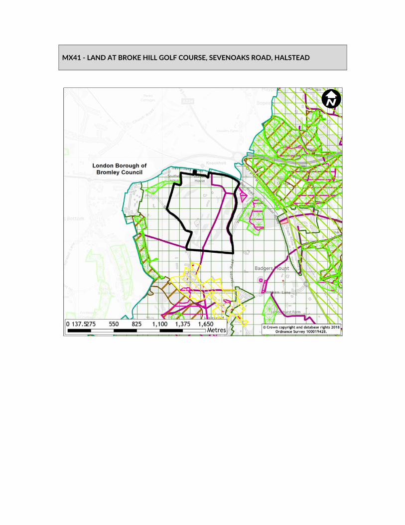
MX41 ‐ LAND AT BROKE HILL GOLF COURSE, SEVENOAKS ROAD, HALSTEAD

SITE DELIVERABILITY ASSESSMENT
SHELAA ref MX41 SHELAA category 3 SHELAA conclusion Unsuitable SHELAA yield 0 SHELAA density 30‐40 DPH When will development be delivered?
1‐5 years
Will an existing use be lost? If yes, what?
Golf course and driving range
Access requirements The existing access onto Sevenoaks Road could be utilised, however an additional access would also be required to serve more than 50 units
Green Belt strength & boundary issues
Strong
Viability issues None identified New infrastructure and community benefits
Extra care / warden‐supported housing Local Needs Housing Local service centre (likely to include community hall, a café, health club facilities, and small‐scale retail) Healthcare provision New Education Facilities, including Primary School, Early Years and Special Education Needs facility Employment space including incubator business space Self build plots Gin distillery (employment and tourism) Station car park A Regional Sports Hub including club/changing facilities Public open space provision
Input from technical specialists
Biodiversity Analysis KCC Highways
Other considerations The loss of the golf course and facilities needs to be addressed. Deliverability summary Yellow – provision of evidenced infrastructure benefits,
moderate/strongly performing Green Belt and proportion of NPPF PDL. For a mix of residential, employment and community facilities.
STAGE 1 SITE APPRAISAL CONCLUSION Deliverability summary Yellow – provision of evidenced infrastructure benefits,
moderate/strongly performing Green Belt and proportion of NPPF PDL. For a mix of residential, employment and community facilities.
Key messages from SA High biodiversity School Health centre Town/ local centre

Land Use Mixed Use – Residential, Mixed Use, Employment. Retail,
Community, Leisure, Open space Developable area (ha) 60.22 Density 40 DPH Site capacity 800 Phasing 1‐5 years, 6‐10 years Overall conclusion
Include in plan, subject to further information
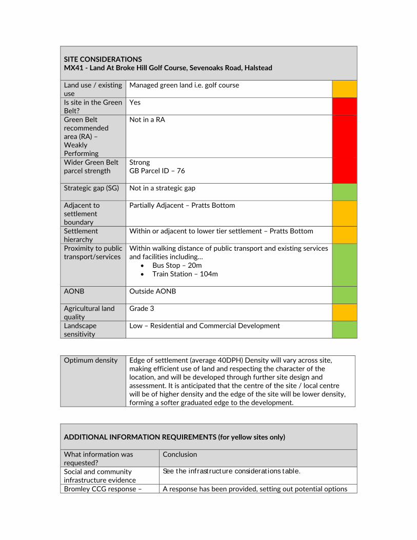
SITE CONSIDERATIONS MX41 ‐ Land At Broke Hill Golf Course, Sevenoaks Road, Halstead Land use / existing use
Managed green land i.e. golf course
Is site in the Green Belt?
Yes
Green Belt recommended area (RA) – Weakly Performing
Not in a RA
Wider Green Belt parcel strength
Strong GB Parcel ID – 76
Strategic gap (SG) Not in a strategic gap
Adjacent to settlement boundary
Partially Adjacent – Pratts Bottom
Settlement hierarchy
Within or adjacent to lower tier settlement – Pratts Bottom
Proximity to public transport/services
Within walking distance of public transport and existing services and facilities including…
Bus Stop – 20m Train Station – 104m
AONB Outside AONB
Agricultural land quality
Grade 3
Landscape sensitivity
Low – Residential and Commercial Development
Optimum density Edge of settlement (average 40DPH) Density will vary across site,
making efficient use of land and respecting the character of the location, and will be developed through further site design and assessment. It is anticipated that the centre of the site / local centre will be of higher density and the edge of the site will be lower density, forming a softer graduated edge to the development.
ADDITIONAL INFORMATION REQUIREMENTS (for yellow sites only) What information was requested?
Conclusion
Social and community infrastructure evidence
See the infrastructure considerations table.
Bromley CCG response – A response has been provided, setting out potential options

Health facilities supported to provide additional facilities both on and off site. Education provider’s response – facilities supported
A response has been provided suggesting current provision cannot be expanded
Transport modelling The information submitted is satisfactory. Network Rail response – reasonable and feasible
A response has been provided, stating that improvements to the existing facility will be needed.
Loss of existing use The information submitted is satisfactory. Sports England and Golf England have no objections.
Ecology and landscape assessment
The information submitted is satisfactory.
SUMMARY OF CONSULTATION COMMENTS Site promoter Quinn Estates – The site is entirely consistent with national policy
and which does not compromise the strategic purpose of the District’s Green Belt. The masterplan depicts 800 homes although there is scope for provision of 1200 homes on site. Proposed 40% affordable housing. The Local Centre will accommodate new medical facilities – most notably a purpose‐built GP surgery and pharmacy. It is a highly‐enclosed and discrete parcel of land, it is a very accessible and quintessential ‘transport hub’ location, and by bringing this redundant land back into active use, we can generate unprecedented public benefits through balanced growth that secures major investment in local services through land value capture instead of taxpayer‐generated resource. No other ‘Exceptional Circumstances’ site can provide such a diverse and meaningful range of economic, social and environmental benefits. Moreover, the land is not crop‐producing BMVL, it is not in an Area of Outstanding Natural Beauty, and it is not subject of other planning designations or physical constraints that would prevent delivery (ecology, flood risk, landscape and so forth). In legal terms, it is therefore sequentially‐preferable to develop this site ahead of other land. Given the absence of development and infrastructure constraints, a new development allocation policy for this site as set out for MX41
DELIVERY Site has been promoted by Agent with support from the landowner The site promoter has indicated that there are no physical or viability constraints that would prevent the site commencing within years 1‐5 Deliver partner appointed Site promotion team appointed and supporting studies provided / in preparation Heads of Terms with sporting providers Conclusion Deliverable / Developable
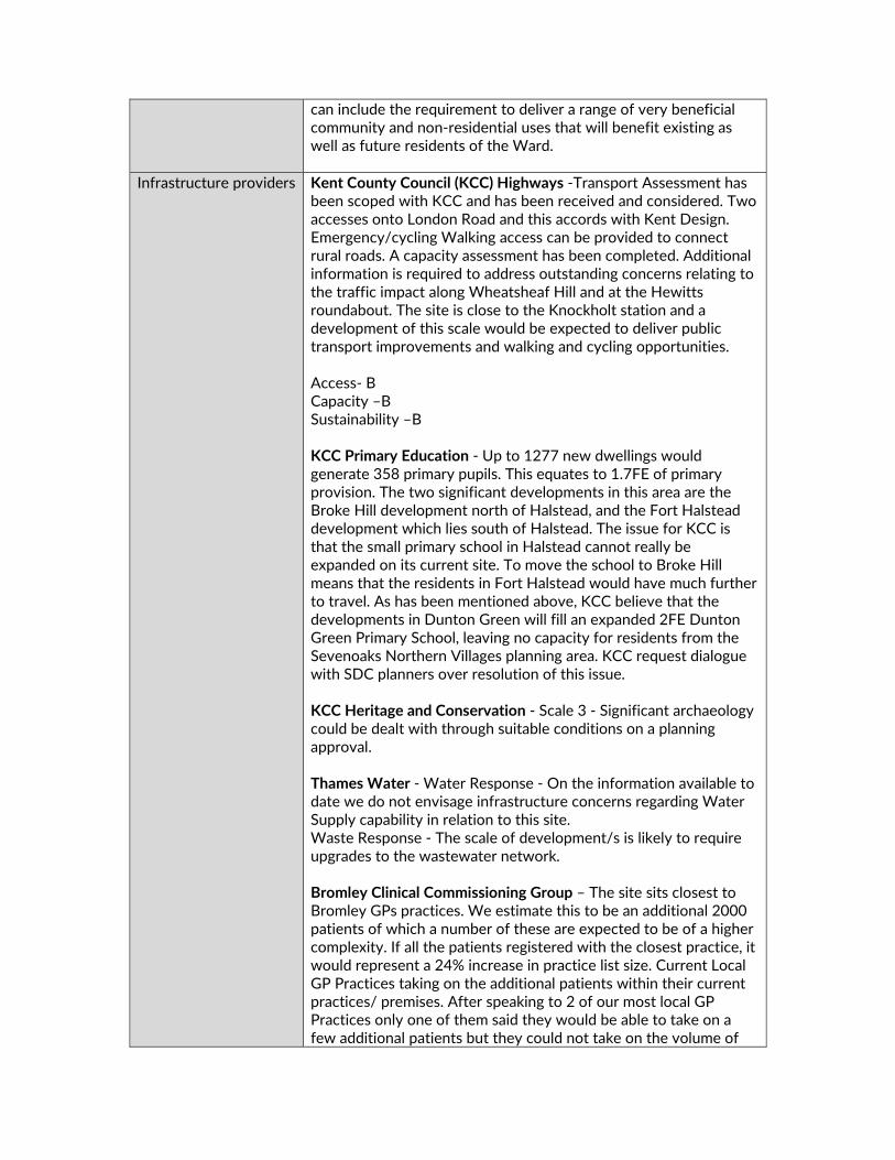
can include the requirement to deliver a range of very beneficial community and non‐residential uses that will benefit existing as well as future residents of the Ward.
Infrastructure providers Kent County Council (KCC) Highways ‐Transport Assessment has been scoped with KCC and has been received and considered. Two accesses onto London Road and this accords with Kent Design. Emergency/cycling Walking access can be provided to connect rural roads. A capacity assessment has been completed. Additional information is required to address outstanding concerns relating to the traffic impact along Wheatsheaf Hill and at the Hewitts roundabout. The site is close to the Knockholt station and a development of this scale would be expected to deliver public transport improvements and walking and cycling opportunities. Access‐ B Capacity –B Sustainability –B KCC Primary Education ‐ Up to 1277 new dwellings would generate 358 primary pupils. This equates to 1.7FE of primary provision. The two significant developments in this area are the Broke Hill development north of Halstead, and the Fort Halstead development which lies south of Halstead. The issue for KCC is that the small primary school in Halstead cannot really be expanded on its current site. To move the school to Broke Hill means that the residents in Fort Halstead would have much further to travel. As has been mentioned above, KCC believe that the developments in Dunton Green will fill an expanded 2FE Dunton Green Primary School, leaving no capacity for residents from the Sevenoaks Northern Villages planning area. KCC request dialogue with SDC planners over resolution of this issue. KCC Heritage and Conservation ‐ Scale 3 ‐ Significant archaeology could be dealt with through suitable conditions on a planning approval. Thames Water ‐ Water Response ‐ On the information available to date we do not envisage infrastructure concerns regarding Water Supply capability in relation to this site. Waste Response ‐ The scale of development/s is likely to require upgrades to the wastewater network. Bromley Clinical Commissioning Group – The site sits closest to Bromley GPs practices. We estimate this to be an additional 2000 patients of which a number of these are expected to be of a higher complexity. If all the patients registered with the closest practice, it would represent a 24% increase in practice list size. Current Local GP Practices taking on the additional patients within their current practices/ premises. After speaking to 2 of our most local GP Practices only one of them said they would be able to take on a few additional patients but they could not take on the volume of
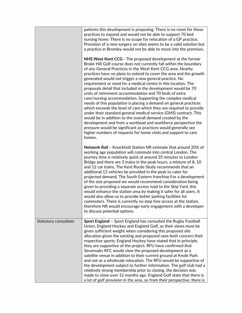
patients this development is proposing. There is no room for these practices to expand and would not be able to support 70 bed nursing home. There is no scope for relocation of a GP practice. Provision of a new surgery on sites seems to be a valid solution but a practice in Bromley would not be able to move into the premises. NHS West Kent CCG ‐ The proposed development at the former Broke Hill Golf course does not currently fall within the boundary of any General Practices in the West Kent CCG area. Nearby practices have no plans to extend to cover the area and the growth generated would not trigger a new general practice. No requirement or need for a medical centre in this location. The proposals detail that included in the development would be 70 units of retirement accommodation and 70 beds of extra care/nursing accommodation. Supporting the complex medical needs of this population is placing a demand on general practices which exceeds the level of care which they are required to provide under their standard general medical service (GMS) contract. This would be in addition to the overall demand created by the development and from a workload and workforce perspective the pressure would be significant as practices would generally see higher numbers of requests for home visits and support to care homes. Network Rail – Knockholt Station NR estimate that around 20% of working age population will commute into central London. The journey time is relatively quick at around 35 minutes to London Bridge and there are 3 trains in the peak hours, a mixture of 8, 10 and 12 car trains. The Kent Route Study recommends that an additional 12 vehicles be provided in the peak to cater for projected demand. The South Eastern franchise For a development of the size proposed we would recommend consideration being given to providing a separate access road to the Skip Yard, this would enhance the station area by making it safer for all users. It would also allow us to provide better parking facilities for commuters. There is currently no step free access at the station, therefore NR would encourage early engagement with a developer to discuss potential options.
Statutory consultees Sport England – Sport England has consulted the Rugby Football Union, England Hockey and England Golf, as their views must be given sufficient weight when considering this proposed site allocation given the existing and proposed uses both concern their respective sports. England Hockey have stated that In principle, they are supportive of the project. RFU have confirmed that Sevenoaks RFC would view the proposed development as a satellite venue in addition to their current ground at Knole Park and not as a wholesale relocation. The RFU would be supportive of the development subject to further information. The golf club had a relatively strong membership prior to closing, the decision was made to close over 12 months ago. England Golf state that there is a lot of golf provision in the area, so from their perspective, there is

still a good level of provision able to cater for the local demand. Therefore, subject to the provision of detail requested above, Sport England has no plans to object to this site allocation. Natural England ‐ Designation Impacted ‐ Kent Downs AONB (setting). What should be considered for this allocation? ‐ Potential to impact the setting of the AONB. Policy should consider the site's location with regards to the AONB, and any impact this allocation may have on the setting of the AONB. Historic England ‐ All sites included in the draft plan as potential housing or mixed development sites should be subject to a detailed heritage assessment prior to inclusion in the final draft Local Plan. Where negative impacts cannot be avoided or limited consideration should be given to reducing the quantum of development on the allocated site, or its removal if mitigation of the harm to heritage significance cannot be achieved. Site descriptions in Appendix A should be enhanced to identify heritage designations (listed buildings, scheduled monuments, registered parks and gardens, etc.) that may be affected by development of allocated sites.
Public including Town/Parish Councils
London Borough of Bromley – Are concerned regarding the transport impact of the proposed development. Knockholt station with 2 services an hour into London is unlikely to be an attractive option compared to private cars. The development would have a significant impact on the capacity of this station at peak times. Additional bus services will be required for the on site primary school and to secondary school. The mixed use nature of the development is welcome but there are concerns that some uses may lead to additional trip generation from outside into the village. Shoreham Parish Council ‐ Both the land at Broke Hill and Pedham Place are situated in the Greenbelt and should not be built on. Badgers Mount Parish Council – The proposal would result in linking of Halstead and Pratts Bottom and result in urban sprawl. Halstead scored high in the Arup Green Belt assessment. Roads are already congested and cannot cope with more traffic. Knockholt station is crowded and has no further capacity. Stonehouse Lane, Cadlocks Hill and Station Road cannot cope with further traffic. The sports facilities do not provide for local residents but for clubs with existing facilities in Sevenoaks town. There is a considerable amount of wildlife in and around the site which will be significantly affected by the proposed development. With all the development in the area Halstead will have more than 3 times the number of houses as the existing village. Halstead Parish Council – The site performed highly in the Arup Green Belt assessment. Do not feel that exceptional circumstances has been met. There is ancient woodland on the site which would

be threatened by development. The infrastructure will not be able to cope with the development. General Public Main Issues (in order of frequency)–
No building on Green Belt/ use brownfield Object to the development Traffic will increase Support sports facilities/ school/ GP surgery on site Roads already congested Environmental impact/ flora & fauna Too many houses/ no housing needed Train station parking insufficient/ poor train service Loss of identity/ urban sprawl Recognise need for some housing Pollution (air/ light/ noise) will increase/ air quality decline Access roads to developments inadequate Allegations of impropriety/ responses from outside the area Inadequate infrastructure/ infrastructure must be in place Sport facilities/ school not needed Need for affordable homes Pressure on schools/ doctors/ more needed Area would be spoiled – character/ views Poor public transport Loss of public footpaths No exceptional circumstances Good location/ near to transport links Increased pressure on utilities Gin distillery/ business park not required Concerned about flooding Severe parking problems already Lack of amenities/ shops Increase in crime/ anti‐social behaviour/ pressure on
policing Support the development
Other interested parties
London Borough of Bromley ‐ As ward councillors in the neighbouring authority representing Chelsfield & Pratt’s Bottom ward we are totally opposed to a development of this nature on green belt land. We are also greatly concerned on the impact it will have on our residents and the local infrastructure. Chelsfield Station is already affected by the overflow from Knockholt Station and this will impact further. The A21 is an extremely busy road already. We cannot see any ‘Exceptional Circumstances’ that warrant this going ahead on Green Belt land and also lose a highly valued recreational area.
CPRE Kent (Sevenoaks District Committee) – object to the development as there are no exceptional circumstances, which meet evidenced needs and the cumulative impact of development in the area will overwhelm infrastructure.

INFRASTRUCTURE CONSIDERATIONS (for greenfield + green belt sites only) What Infrastructure is proposed? (updated to incorporate Draft Local Plan representations from site promoter)
Does it meet an evidenced existing need?
Hockey and Rugby facilities 7.7 ha for sports provision, facilities provided on virtual freehold basis
Playing Pitch Strategy (2018) Sevenoaks Hockey Club and Sevenoaks Rugby Club – agreed HoT National Governing Body
Station car park Current on street parking issues Local Centre – retail, café, community hall, health club with swimming pool Build of new GP medical facility
Centre primarily to serve new development CCG s have not confirmed they would occupy in this location
Business Hub – purpose built serviced B1 office space ‐ 2.1 ha of employment land
Economic Needs Study
Education – 2FE primary school, early years, SEN, S106 contribution to secondary ‐ (1.7ha land)
KCC education Kent Commissioning Plan for Education 2018‐2022
Care home / warden‐assisted accommodation 70 beds (retirement home) 70 beds extra care
Local Housing Needs Study (2017)
Additional funding streams? Other sites available?
Limited funding from other sources Infrastructure proposals primarily related to district‐wide need
Compensatory improvements in Green Belt?
Creation of parkland – retaining mature trees and landscape enhancement. Management Trust / gift to PC. Provision of allotments
STAGE 2 SITE APPRAISAL CONCLUSION Is this site acceptable for the proposed development? YES
LOCAL PLAN STRATEGY ASSESSMENT Relevant Local Plan strategy Evidence
Housing – Greenfield site in the Green Belt
Infrastructure proposals do not outweigh harm to strongly performing belt.
Does this site meet the relevant local plan strategy? NO

OVERALL CONCLUSION Do not include Land Use Developable area (ha) Density Site capacity Phasing
MX44 ‐ LAND WEST OF ROMANI WAY, EDENBRIDGE
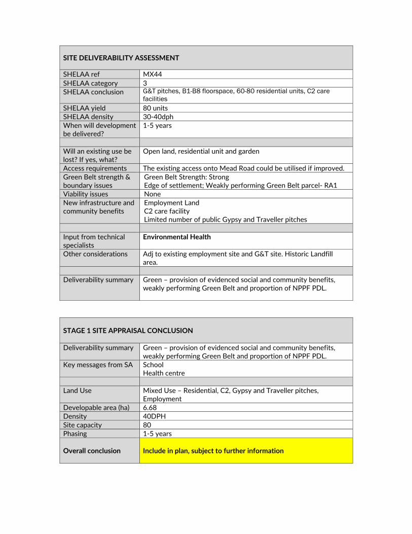
SITE DELIVERABILITY ASSESSMENT
SHELAA ref MX44 SHELAA category 3 SHELAA conclusion G&T pitches, B1-B8 floorspace, 60-80 residential units, C2 care
facilities SHELAA yield 80 units SHELAA density 30‐40dph When will development be delivered?
1‐5 years
Will an existing use be lost? If yes, what?
Open land, residential unit and garden
Access requirements The existing access onto Mead Road could be utilised if improved. Green Belt strength & boundary issues
Green Belt Strength: Strong Edge of settlement; Weakly performing Green Belt parcel‐ RA1
Viability issues None New infrastructure and community benefits
Employment Land C2 care facility Limited number of public Gypsy and Traveller pitches
Input from technical specialists
Environmental Health
Other considerations Adj to existing employment site and G&T site. Historic Landfill area.
Deliverability summary Green – provision of evidenced social and community benefits,
weakly performing Green Belt and proportion of NPPF PDL.
STAGE 1 SITE APPRAISAL CONCLUSION Deliverability summary Green – provision of evidenced social and community benefits,
weakly performing Green Belt and proportion of NPPF PDL. Key messages from SA School
Health centre Land Use Mixed Use – Residential, C2, Gypsy and Traveller pitches,
Employment Developable area (ha) 6.68 Density 40DPH Site capacity 80 Phasing 1‐5 years Overall conclusion
Include in plan, subject to further information
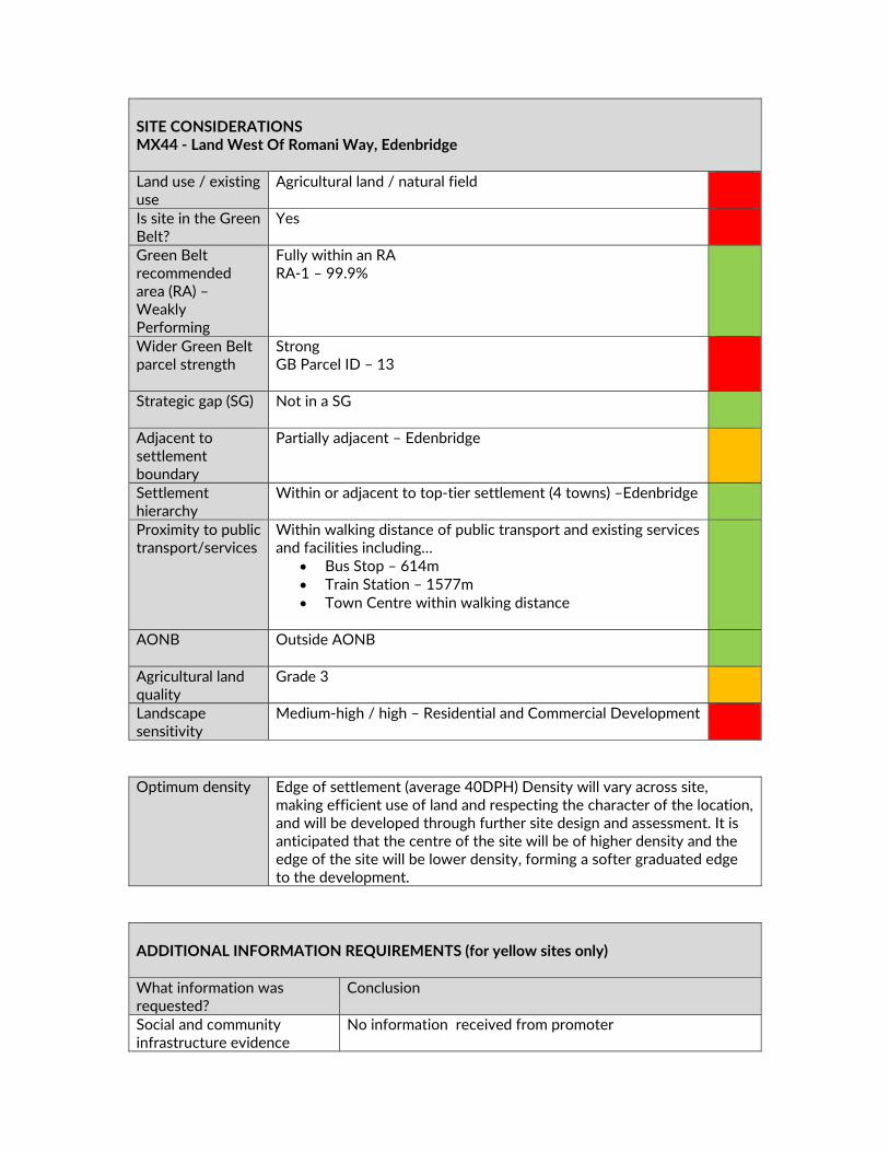
SITE CONSIDERATIONS MX44 ‐ Land West Of Romani Way, Edenbridge Land use / existing use
Agricultural land / natural field
Is site in the Green Belt?
Yes
Green Belt recommended area (RA) – Weakly Performing
Fully within an RA RA‐1 – 99.9%
Wider Green Belt parcel strength
Strong GB Parcel ID – 13
Strategic gap (SG) Not in a SG
Adjacent to settlement boundary
Partially adjacent – Edenbridge
Settlement hierarchy
Within or adjacent to top‐tier settlement (4 towns) –Edenbridge
Proximity to public transport/services
Within walking distance of public transport and existing services and facilities including…
Bus Stop – 614m Train Station – 1577m Town Centre within walking distance
AONB Outside AONB
Agricultural land quality
Grade 3
Landscape sensitivity
Medium‐high / high – Residential and Commercial Development
Optimum density Edge of settlement (average 40DPH) Density will vary across site,
making efficient use of land and respecting the character of the location, and will be developed through further site design and assessment. It is anticipated that the centre of the site will be of higher density and the edge of the site will be lower density, forming a softer graduated edge to the development.
ADDITIONAL INFORMATION REQUIREMENTS (for yellow sites only) What information was requested?
Conclusion
Social and community infrastructure evidence
No information received from promoter

Transport modelling A Transport Assessment will be required Third party response – extensions
None received
Indicative layout plan None received Ecology and landscape assessment
Ecology and landscape assessment will be required
SUMMARY OF CONSULTATION COMMENTS Site promoter The site is still being promoted.
Infrastructure providers Kent County Council (KCC) Highways ‐ Full Transport Statement
required before full assessment can be made. Access – B Capacity –B Sustainability – B Edenbridge is located in a rural area without the benefit of high quality principle roads. It is accessed via B roads to the north and to the east and a ‘c class’ road (Lingfield Road) to the west. These roads are single carriageway with constraints along their routes including villages, bends and narrowings. There are no obvious improvements to bring these routes up to a principal route status. Development which leads to any significant increase in traffic movements is likely to lead to traffic issues along these routes. Edenbridge does however benefit from 2 rail stations providing links between Uckfield/London and Redhill and Tonbridge. KCC Secondary Education ‐ Many people from Edenbridge have wanted a secondary school since the closure of Eden Valley School in 2002. KCC offers no opposition to this aspiration, but any new school must be viable. The existing secondary demand, added to the additional demand created if ALL the Edenbridge sites are developed would still only create about 4FE. This is because many Edenbridge students would still prefer to attend Grammar or faith schools in Tonbridge or Tunbridge Wells. A point of support would be available if the school was located in the north of the town, so making it more accessible for students from Westerham.
DELIVERY Site has been promoted by landowner who is in the process of appointing a delivery partner Landowner has indicated that there are no physical or viability constraints that would prevent the site commencing within years 1‐5 Conclusion Deliverable / Developable

A 4FE secondary school in Edenbridge could be vulnerable financially, but if such a school can be proven to be part of the whole secondary solution for Sevenoaks, KCC would of course, give it serious consideration. NHS West Kent CCG ‐ There is an existing need in Edenbridge and a new combined hospital and GP surgery in Edenbridge has been agreed following public consultation in 2017. The CCG can therefore confirm that the provision of a health facility in this area is supported and work is underway to determine the preferred site. Using the average occupancy figure of 2.34 per dwelling the growth in Edenbridge is expected to be c. 3000 new patient registrations; the project would allow for the proposed growth arising from the local plan to be accommodated.
Statutory consultees High Weald AONB Unit ‐With respect to the Edenbridge sites, particularly H0189, MX44 and MX51, it should be acknowledged that development could affect the setting of the High Weald AONB and this should be taken into account in the decision on whether to allocate and in the design of any future allocation. Setting affects are not just visual but also include impacts on habitats and watercourses connecting into the High Weald such as the River Eden and its environs. KCC SuDS ‐ From a desk review, it is not clear where the discharge destination for any surface water generated from the development would be directed. There are no surface water sewers within the vicinity. Given the underlying geology, any surface water generated by the development will need to be attenuated within the site. There do not appear to be any ordinary watercourses which would convey surface water from the site. We have concerns as to the discharge destination from this site. This will require assessment. An infrastructure upgrade in sewers in the vicinity of the site may be required. KCC Heritage and Conservation ‐ Scale 3 ‐ Significant archaeology could be dealt with through suitable conditions on a planning approval.
Public including Town/Parish Councils
Edenbridge Town Council ‐ Members do not support the release of Green Belt at this site for the following reasons:
Impact on view from Den Cross Access from Hever Road and Mead Road unsuitable Does not meet social and community benefit Provision of additional G&T pitches would exceed best
practice limit of 15 Over provision of elderly persons home already in
Edenbridge Hever Parish Council – The site does not promote exceptional circumstances to build on the Green Belt. Access from Hever Road

is inadequate. There is no evidence a further nursing home is required. Cumulative Gypsy and Traveller site and the Seven Acres site would be inappropriate for the area. General Public Main Issues (in order of frequency)– Access roads to development inadequate No building on Green Belt/ use brownfield Traffic will increase Object to the development Gypsy and traveller pitches not required Severe parking problems already No exceptional circumstances Environmental impacts/ flora & fauna Too many houses/ no housing needed Area would be spoiled – character/ views
Other interested parties
CPRE Kent (Sevenoaks District Committee) – The site should be removed as no need has been demonstrated for a residential medical/nursing centre. An 80‐bed nursing home is currently under construction alongside the town's relief road. However, some limited expansion of the gypsy site might be considered, perhaps separate to existing site.
INFRASTRUCTURE CONSIDERATIONS (for greenfield + green belt sites only) What Infrastructure is proposed? (updated to incorporate Draft Local Plan representations from site promoter)
Does it meet an evidenced existing need?
Gypsy and Traveller pitches GTAA (2017) Employment Space Economic Needs Study Older person’s care facility Local Housing Needs Study Additional funding streams? Other sites available?
Not identified No ‐ land adjacent to public G&T site
Compensatory improvements in Green Belt?
Not identified
STAGE 2 SITE APPRAISAL CONCLUSION Is this site acceptable for the proposed development? YES
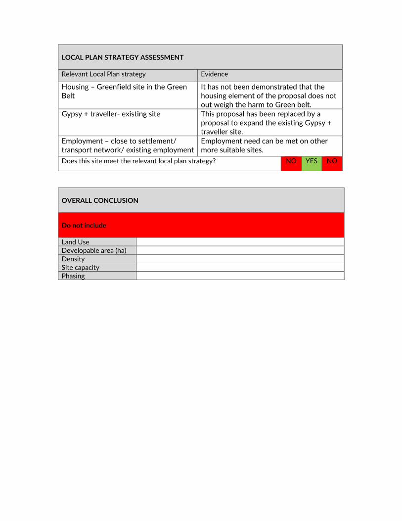
LOCAL PLAN STRATEGY ASSESSMENT Relevant Local Plan strategy Evidence
Housing – Greenfield site in the Green Belt
It has not been demonstrated that the housing element of the proposal does not out weigh the harm to Green belt.
Gypsy + traveller‐ existing site This proposal has been replaced by a proposal to expand the existing Gypsy + traveller site.
Employment – close to settlement/ transport network/ existing employment
Employment need can be met on other more suitable sites.
Does this site meet the relevant local plan strategy? NO YES NO
OVERALL CONCLUSION Do not include Land Use Developable area (ha) Density Site capacity Phasing

MX49 ‐ LAND WEST OF CHEVENING ROAD, CHIPSTEAD

SITE DELIVERABILITY ASSESSMENT
SHELAA ref MX49 / HO53 SHELAA category 3 SHELAA conclusion Deliverable SHELAA yield 5‐7 residential units SHELAA density 30‐40 DPH When will development be delivered?
1‐5 years
Will an existing use be lost? If yes, what?
Residential dwelling, outbuilding, open field
Access requirements Access from Chevening Road Green Belt strength & boundary issues
Green Belt Strength: Moderate
Viability issues No issues known New infrastructure and community benefits
Community car park (to serve primary school), community play space, ecology enhancements and local needs housing
Input from technical specialists
Kent Downs AONB Unit ‐ Would only support a frontage development of this site to correspond with existing settlement pattern which is confined to houses fronting the road on the east side of the street. Environment Agency ‐ This site is adjacent to a historic landfill site, and is therefore likely to require site investigation works to characterise the contamination status of the site.
Environmental Health
Other considerations Planning application pending (18/01036) for 1 residential unit on south eastern portion of the site. Historic landfill site.
Deliverability summary Yellow – provision of evidenced infrastructure benefits,
moderate/strongly performing Green Belt and proportion of NPPF PDL.
STAGE 1 SITE APPRAISAL CONCLUSION Deliverability summary Yellow – provision of evidenced infrastructure benefits,
moderate/strongly performing Green Belt and proportion of NPPF PDL.
Key messages from SA Kent Downs AONB Health centre Bus stop Town/local centre
Land Use Mixed Use ‐ Residential, open space and community use Developable area (ha) 1.71

Density 40 DPH Site capacity 30 units Phasing 1‐5 years Overall conclusion
Include in plan, subject to further information
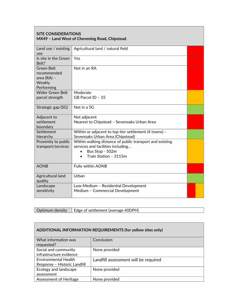
SITE CONSIDERATIONS MX49 – Land West of Chevening Road, Chipstead Land use / existing use
Agricultural land / natural field
Is site in the Green Belt?
Yes
Green Belt recommended area (RA) – Weakly Performing
Not in an RA
Wider Green Belt parcel strength
Moderate GB Parcel ID – 55
Strategic gap (SG) Not in a SG
Adjacent to settlement boundary
Not adjacent Nearest to Chipstead – Sevenoaks Urban Area
Settlement hierarchy
Within or adjacent to top‐tier settlement (4 towns) – Sevenoaks Urban Area (Chipstead)
Proximity to public transport/services
Within walking distance of public transport and existing services and facilities including…
Bus Stop ‐ 502m Train Station – 3115m
AONB Fully within AONB
Agricultural land quality
Urban
Landscape sensitivity
Low‐Medium – Residential Development Medium – Commercial Development
Optimum density Edge of settlement (average 40DPH) ADDITIONAL INFORMATION REQUIREMENTS (for yellow sites only) What information was requested?
Conclusion
Social and community infrastructure evidence
None provided
Environmental Health Response – Historic Landfill
Landfill assessment will be required
Ecology and landscape assessment
None provided
Assessment of Heritage None provided

impact
SUMMARY OF CONSULTATION COMMENTS Site promoter Country House Homes – The site continues to be promoted.
Infrastructure providers Kent County Council (KCC)Highways – The pedestrian crossing
would be acceptable in principle. The details would need to be determined with KCC Agreements Team through a Section 278 Agreement. Access –B Capacity –A Sustainability –B In principle, the proposal for a mixed‐use scheme of residential dwellings, community green and community car park would be acceptable in terms of capacity. The number of residential dwellings proposed would not be likely to lead to any significant impact on the local and strategic network. The community car park would meet a need of providing car parking for parents, thus providing some relief to the congestion of Chevening Road during peak hours. The main concern remains the visibility from the proposed access. As noted above, it is suggested that the hedge is reduced to 0.6 metres in height if possible. The visibility could be conditioned as part of any planning approval. Kent County Council Primary Education ‐ for Sevenoaks Urban Area up to 1101 new dwellings would generate 308 primary pupils. This equates to 1.5FE of primary provision. Sevenoaks Planning Area covers the town of Sevenoaks, Riverhead, Dunton Green, Chevening and extends as far south as Sevenoaks Weald. There is currently a small surplus of capacity in Sevenoaks Planning Area but this fluctuates and cannot be applied into the planning process. The PPR from the Sevenoaks town sites, especially MX43, would require additional provision of 1FE. The primary schools in Sevenoaks have all been assessed for viability for expansion over the last seven years. With the exception of Dunton Green PS, it is unlikely that any other
DELIVERY Site has been promoted by Agent with support from the landowner The site promoter has indicated that there are no physical or viability constraints that would prevent the site commencing within years 1‐5 Site promotion team appointed and supporting studies provided / in preparation Conclusion Deliverable / Developable

expansions will be possible due to site constraints. Dunton Green could be expanded, although currently the PPR that was expected from Ryedale (circa 450) dwellings has yet to materialise. It may be that an expansion of Dunton Green could accommodate the local PPR from Ryedale and the local PPR from MX50. Kent County Council Secondary Education ‐ The town of Sevenoaks will likely need a new 6FE secondary school if the numbers of dwellings recorded in the draft Local Plan are built in the district. It could be built anywhere in or outside the town, but KCC is conscious of the Green Belt issues. Nevertheless, with the amount of housing development being proposed in this Draft Local Plan, without a new 6FE school, KCC would have difficulty supporting housing development in the Sevenoaks, Halstead and Dunton Green areas. Thames Water ‐ Water Response ‐ Not our water area Waste Response ‐ On the information available to date we do not envisage infrastructure concerns regarding wastewater networks in relation to this development/s. It is recommended that the Developer and the Local Planning Authority liaise with Thames Water at the earliest opportunity to advise of the developments phasing. NHS West Kent CCG – The proposed development is for 26‐30 houses. The expected need arising from this will be between c. 60 and 70 new patient registrations. The proposed development falls within the boundaries of four existing general practices. This development when considered on its own (and across a number of practices) will not require specific general practice capacity through new infrastructure to be created.
Statutory consultees Kent downs AONB Unit ‐ The AONB Unit only considers a frontage development of this site to be acceptable, to correspond with existing settlement pattern which is confined to houses fronting the road on the east side of the street and the sites rural fringe location with the site on the edge of the settlement. The AONB Unit consider that there should be a requirement for the frontage boundary treatment to comprise hedgerows to reflect the sites location on the edge of the village and houses to be limited to two stories and each to be accessed directly from Chevening Road. Natural England ‐ Designation Impacted ‐ Kent Downs AONB. What should be considered for this allocation? ‐ The policy needs to consider the site’s location within the AONB, ensuring the character of the AONB is protected and enhanced, with reference to the Management Plan, NCA and LCA. Significant Concerns ‐ This allocation concerns undeveloped land adjacent within the AONB and adjacent to the M25. Should this application be taken forward, robust measures to protect and enhance the AONB together with suitable mitigation measures should be carefully considered, and these should be specified in the policy wording for this allocation.

KCC SuDS ‐ Though the site is not within an area of flood risk it is traversed by a possible overland flow path. There are no surface water sewers within the vicinity. The underlying geology is unlikely to be feasible for infiltration. It is assumed that surface water will be discharged to the ordinary watercourse on the southern boundary. Space for attenuation of surface water will need to be included within the layout. This may impact number of dwellings to be delivered and needs due consideration. The overland flow path will need to be assessed and avoided if needed. KCC Heritage and Conservation ‐ Potential for prehistoric remains due to location close to River Terrace Gravels and for post medieval to modern remains associated with the late 19th century or earlier Froghole Farm. There is some potential for as yet unknown archaeology. Scale 3 ‐ Significant archaeology could be dealt with through suitable conditions on a planning approval. Historic England ‐ All sites included in the draft plan as potential housing or mixed development sites should be subject to a detailed heritage assessment prior to inclusion in the final draft Local Plan. Where negative impacts cannot be avoided or limited consideration should be given to reducing the quantum of development on the allocated site, or its removal if mitigation of the harm to heritage significance cannot be achieved. Site descriptions in Appendix A should be enhanced to identify heritage designations (listed buildings, scheduled monuments, registered parks and gardens, etc.) that may be affected by development of allocated sites.
Public including Town/Parish Councils
Chevening Parish Council – Object to the development. Overdevelopment of the site and add to strain on the existing infrastructure. Chevening Road cannot cope with additional cars. Another play facility is not required. General Public Main Issues (in order of frequency)– Roads already congested Traffic will increase/ safety concerns – dangerous Object to the development Inadequate infrastructure/ infrastructure must be in place/
bridge not able to cope No building on Green belt/ AONB/ use brownfield Pressure on schools/ doctors/ more needed Severe parking problems already/ parking would need to be
addressed Not aware of meeting/ public should have been consulted
earlier/ not enough notice Concerns about flooding/ drainage issues Area would be spoilt – character/ views/ must be kept as a
village/ won’t be in keeping Too many houses/ no housing needed

Do not need another playground/ recreational ground Pollution will increase/ air quality/ noise/ disruption Recognise need for some housing Lack of amenities/ shops Poor public transport Environmental impact/ flora & fauna Access roads to developments inadequate No exceptional circumstances Loss of identity/ urban sprawl Allegations of impropriety (previous Headmistress) Increase in crime/ anti‐social behaviour/ pressure on policing Pressure on utilities/ lack of connectivity/ pressure on services Support the development Proposed access roads are privately owned/ boundary dispute/
land owned by residents
Other interested parties
No comments received
INFRASTRUCTURE CONSIDERATIONS (for Greenfield + Green belt sites only) What Infrastructure is proposed? (updated to incorporate Draft Local Plan representations from site promoter)
Does it meet an evidenced existing need?
Community car park School not supportive of proposal to provide car park in this location.
Playspace / congregation green Chipstead already has a playground off Chevening Road
Additional funding streams? Other sites available?
School would prefer a car‐park site on the same side of the road Existing playground
Compensatory improvements in Green Belt?
Green space and ecology enhancement
STAGE 2 SITE APPRAISAL CONCLUSION Is this site acceptable for the proposed development? YES
LOCAL PLAN STRATEGY ASSESSMENT Relevant Local Plan strategy Evidence + community
Housing – Greenfield site in the Green Belt
Infrastructure proposals are not supported by the relevant users +

provider.
Does this site meet the relevant local plan strategy? NO
OVERALL CONCLUSION Do not include Land Use Developable area (ha) Density Site capacity Phasing
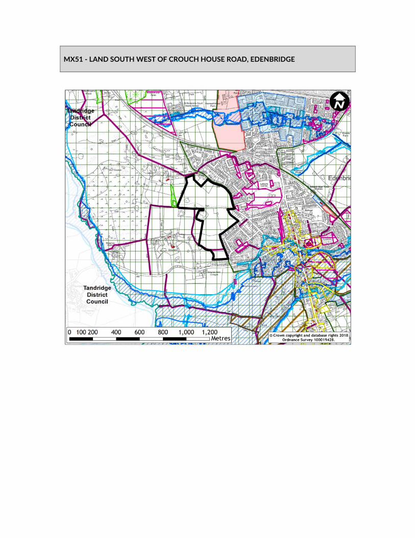
MX51 ‐ LAND SOUTH WEST OF CROUCH HOUSE ROAD, EDENBRIDGE

SITE AVAILABILITY ASSESSMENT
SHELAA ref MX51 / HO158 SHELAA category 4 SHELAA conclusion Deliverable and Developable SHELAA yield 264 ‐ 352 SHELAA density 30‐40 DPH
When will development be delivered?
1‐5 years
Will an existing use be lost? If yes, what?
Agricultural fields
Access requirements New access onto Crouch House Road would be required as well as an additional access to serve more than 50 units. Additional access could be taken off Springfield Road
Green Belt strength & boundary issues
Strong. Adjacent to settlement boundary
Viability issues None identified New infrastructure and community benefits
Land for primary care/GP facility; Land for health services Land for education provision
Input from technical specialists
Environment Agency‐ There are many ponds, a priority habitat, in this site (NERC Sc 41). Development proposals must include protection of them or mitigation for any harm / loss that might occur to them. KCC Highways Clinical Commissioning Group KCC Education
Other considerations It would need to be demonstrated that the relevant health and education providers would support provision in this location.
Deliverability summary Yellow – provision of infrastructure benefits and
moderate/strongly performing Green Belt. STAGE 1 SITE APPRAISAL CONCLUSION Deliverability summary Yellow – provision of infrastructure benefits and
moderate/strongly performing Green Belt. Key messages from SA High landscape sensitivity Land Use Mixed Use – Residential, Health and Education Developable area (ha) 18.39 Density 40 DPH Site capacity 250 units Phasing 1‐5 years & 6‐10 years Overall conclusion
Include in plan, subject to further information

SITE CONSIDERATIONS MX51 ‐ Land South West Of Crouch House Road, Edenbridge Land use / existing use
Agricultural land / natural field
Is site in the Green Belt?
Yes
Green Belt recommended area (RA) – Weakly Performing
Not in an RA
Wider Green Belt parcel strength
Strong GB Parcel ID – 14
Strategic gap (SG) Not in a SG
Adjacent to settlement boundary
Fully adjacent – Edenbridge
Settlement hierarchy
Within or adjacent to top‐tier settlement (4 towns) – Edenbridge
Proximity to public transport/services
Within walking distance of public transport and existing services and facilities including…
Bus Stop – 14m Train Station – 901m Town Centre within walking distance
AONB Outside AONB
Agricultural land quality
Grade 3
Landscape sensitivity
Medium‐high / high – Residential and Commercial
Optimum density Edge of settlement (average 40DPH) Density will vary across site,
making efficient use of land and respecting the character of the location, and will be developed through further site design and assessment. It is anticipated that the centre of the site will be of higher density and the edge of the site will be lower density, forming a softer graduated edge to the development.
ADDITIONAL INFORMATION REQUIREMENTS (for yellow sites only) What information was requested?
Conclusion
Social and community infrastructure evidence
See the infrastructure considerations table.
West Kent CCG – Health hub supported
It is demonstrated that the provision of a new health facility in Edenbridge is supported.
KCC Highways response – sufficient capacity
It is demonstrated that that there is insufficient capacity on the highway network.
Ecology and landscape assessment
A preliminary ecological assessment has been provided.
Indicative layout plan A indicative layout plan has been provided. Transport modelling A Transport Technical Note has been provided but no
transport model.
SUMMARY OF CONSULTATION COMMENTS Site promoter DHA Planning ‐ Edenbridge is well served by existing infrastructure
and represents a sustainable location that should accommodate additional growth. Furthermore, of the sites available, our client’s land is most accessible and the least constrained by flood risk. We consider that the assumptions about ‘exceptional circumstances’ remain extremely flawed and do not represent the guidance set out within case law nor the recently published NPPF. In this regard, housing need alone is sufficient to positively plan for Green Belt review as part of the local plan review process, yet the draft strategy does not recognise this important point.
Infrastructure providers Kent County Council (KCC) Highways ‐ Edenbridge is located in a rural area without the benefit of high quality principle roads. It is accessed via B roads to the north and to the east and a ‘c class’ road (Lingfield Road) to the west. These roads are single carriageway with constraints along their routes including villages, bends and narrowings. There are no obvious improvements to bring these routes up to a principal route status. Development which leads to any significant increase in traffic movements is likely
DELIVERY Site has been promoted by Agent with support from the landowner The site promoter has indicated that there are no physical or viability constraints that would prevent the site commencing within years 1‐5 Site promotion team appointed and supporting studies provided / in preparation Conclusion Deliverable / Developable
to lead to traffic issues along these routes. Edenbridge does however benefit from 2 rail stations providing links between Uckfield/London and Redhill and Tonbridge. Access – B Capacity – B Sustainability ‐ A NHS West Kent CCG – There is an existing need in Edenbridge and a new combined hospital and GP surgery in Edenbridge has been agreed following public consultation in 2017. The CCG can therefore confirm that the provision of a health facility in this area is supported and work is underway to determine the preferred site. Using the average occupancy figure of 2.34 per dwelling the growth in Edenbridge is expected to be c. 3000 new patient registrations; the project would allow for the proposed growth arising from the local plan to be accommodated. KCC Secondary Education ‐ Many people from Edenbridge have wanted a secondary school since the closure of Eden Valley School in 2002. KCC offers no opposition to this aspiration, but any new school must be viable. The existing secondary demand, added to the additional demand created if ALL the Edenbridge sites are developed would still only create about 4FE. This is because many Edenbridge students would still prefer to attend Grammar or faith schools in Tonbridge or Tunbridge Wells. A point of support would be available if the school was located in the north of the town, so making it more accessible for students from Westerham. A 4FE secondary school in Edenbridge could be vulnerable financially, but if such a school can be proven to be part of the whole secondary solution for Sevenoaks, KCC would of course, give it serious consideration. KCC Primary Education ‐ Up to 1346 new dwellings would generate 377 primary pupils. This equates to 1.8 FE of primary provision. There is currently sufficient capacity at Edenbridge Primary School to accommodate about 100‐150 additional primary pupils across all seven‐year groups. If all options are progressed, an additional 1FE would be required. Edenbridge Primary School was enlarged two years ago and cannot be enlarged again. The two other primary schools in the planning area (Four Elms PS and Hever CE PS) have small sites and do not lend themselves to enlargement. If the demand increases beyond that forecast, Edenbridge Town will need a new 1FE Primary school built in or near the town.
Statutory consultees High Weald AONB Unit ‐ With respect to the Edenbridge sites, particularly H0189, MX44 and MX51, it should be acknowledged that development could affect the setting of the High Weald AONB and this should be taken into account in the decision on
whether to allocate and in the design of any future allocation. Setting affects are not just visual but also include impacts on habitats and watercourses connecting into the High Weald such as the River Eden and its environs. KCC SuDS ‐ From a desk review, it is not clear where the discharge destination for any surface water generated from the development would be directed. KCC has major concerns as to the discharge destination from this site. A major infrastructure upgrade in sewers in the vicinity of the site may be required. KCC Heritage and Conservation ‐ Preliminary Heritage Assessment ‐ Potential for prehistoric remains with proximity of River Terrace Gravels and for Roman remains with a roman road considered to follow the alignment of the High Street and a Roman coin located within the site. The site contains a possible post medieval to modern farm outbuilding or barn identified on the Historic Farmstead survey (HE). Potential for as yet unknown multi‐period remains. Scale 3 ‐ Significant archaeology could be dealt with through suitable conditions on a planning approval.
Public including Town/Parish Councils
Edenbridge Town Council – Object to the development as it would lead to further encroachment into the Green Belt and does not meet exceptional circumstances. The infrastructure cannot cope with a large increase in traffic. The development will impact on flooding. General Public Main Issues (in order of frequency)– No building on green belt/ use brownfield Traffic will increase Concerned about flooding Access roads to developments inadequate Environmental impact / flora & fauna Medical centre should be more central Object to development / previous plans have been rejected Inadequate infrastructure / infrastructure must be in place Poor public transport / pressure on public transport Pressure on schools / doctors / more needed Roads already congested Already enough development planned for Edenbridge / too
many houses proposed Severe parking problems already No exceptional circumstances Pollution will increase/ air quality Lack of employment opportunities Lack of amenities/ shops Recognise need for some housing
Other interested parties
CPRE Kent (Sevenoaks District Committee) ‐ The site should be removed from Local Plan as the land is Green Belt with no local support for medical centre here and therefore no exceptional

circumstance proven. INFRASTRUCTURE CONSIDERATIONS (for greenfield + green belt sites only) What Infrastructure is proposed? (updated to incorporate Draft Local Plan representations from site promoter)
Does it meet an evidenced existing need?
Land for primary care / GP facility CCG – but this is not the CCG preferred location for this facility Draft Neighbourhood Plan identifies need for health facility
Older person’s housing Local Housing Needs Study Additional funding streams? Other sites available?
Not identified Four Elms Road
Compensatory improvements in Green Belt?
Open space, landscaping
STAGE 2 SITE APPRAISAL CONCLUSION Is this site acceptable for the proposed development? YES
LOCAL PLAN STRATEGY CONCLUSION Relevant Local Plan strategy Evidence
Housing – Greenfield in the Green Belt
Infrastructure proposals not supported by relevant provider.
Does this site meet the relevant local plan strategy? NO
OVERALL CONCLUSION Do not include Land Use Developable area (ha) Density Site capacity Phasing

MX52/MX53 – CORINTHIANS AND BANCKSIDE, FAWKHAM / HARTLEY

SITE DELIVERABILITY ASSESSMENT
SHELAA ref MX52 / MX53/HO162/HO163/HO169 SHELAA category 3/4 SHELAA conclusion Unsuitable SHELAA yield 0 SHELAA density 30‐40 DPH When will development be delivered?
N/A
Will an existing use be lost? If yes, what?
Agricultural field used for arable crop production (MX53) Sports pitches, a golf course and associated buildings. The site also includes the Gay Dawn Farm complex containing a number of buildings in commercial and agricultural use. (MX52)
Access requirements The existing access is onto Valley Road to the west (MX52) There is an existing access onto Parkfield which could be utilised. An additional access would also be required to serve more than 50 units and could be taken from Fawkham Road. (MX53)
Green Belt strength & boundary issues
Strength: Strong Weak performing green belt RA‐27
Viability issues No constraints that could render the site financially unviable are identified at this time.
New infrastructure and community benefits
Retirement village ‐ specialist elderly care accommodation Satellite GP service Improved sports provision, including improved golf facilities, indoor sports and 4G pitch Replacement primary school & special education needs school New employment floorspace, incubator and start up Improved vehicle/cycle links between Valley Road and Ash Road, Open space & allotments Self‐build plots New Country Park including Pedestrian and cycle links to Longfield railway station, children’s adventure playground and outdoor gym, café, woodland walk, Relief road to allow improved traffic conditions on Castle Hill.
Input from technical specialists
Environment Agency ‐ There are at least two ponds, a priority habitat, in this site (NERC Sc 41). Development proposals must include protection of them or mitigation for any harm / loss that might occur to them. Natural England Environmental Health KCC Countryside Access KCC Highways
Other considerations Sporting facilities and open space would need to be retained or re‐provided as part of any redevelopment. (MX52) Presence of ancient woodland adjacent to the site would require protection and a buffer between the woodland and any future development.

Western part of the site is very open and has an attractive landscape character as it forms the valley side. (MX53)
Deliverability summary Yellow – provision of infrastructure benefits and includes
moderate/strongly/weakly performing Green Belt. STAGE 1 SITE APPRAISAL CONCLUSION Deliverability summary Yellow – provision of infrastructure benefits and includes
moderate/strongly/weakly performing Green Belt. Key messages from SA Zone 1 SPZ (MX53)
Ancient woodland (MX52) School Health centre Bus stop (MX52) Town/local centre
Land Use Mixed Use – Residential, Employment, Health, Education, Sports
and Open Space Developable area (ha) 74.6 Density 40 DPH Site capacity 800 units Phasing 1‐5 years & 6‐10 years Overall conclusion
Include in plan, subject to further information
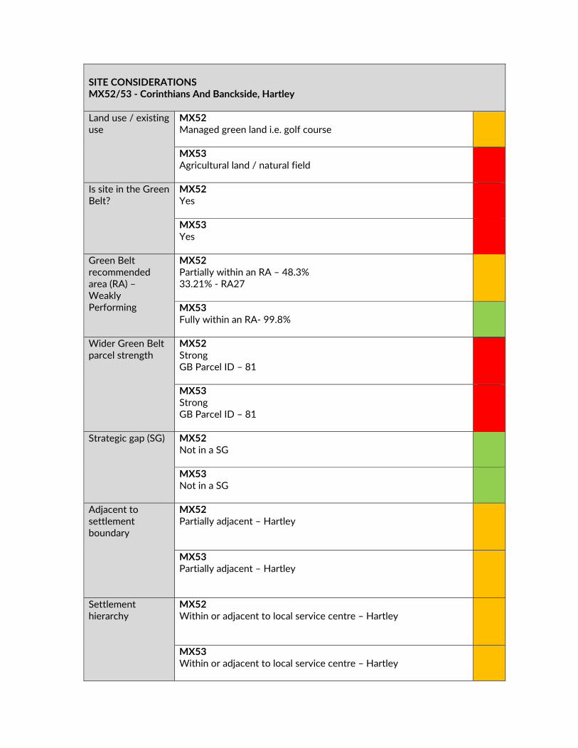
SITE CONSIDERATIONS MX52/53 ‐ Corinthians And Banckside, Hartley Land use / existing use
MX52 Managed green land i.e. golf course
MX53 Agricultural land / natural field
Is site in the Green Belt?
MX52 Yes
MX53 Yes
Green Belt recommended area (RA) – Weakly Performing
MX52 Partially within an RA – 48.3% 33.21% ‐ RA27
MX53 Fully within an RA‐ 99.8%
Wider Green Belt parcel strength
MX52 Strong GB Parcel ID – 81
MX53 Strong GB Parcel ID – 81
Strategic gap (SG) MX52 Not in a SG
MX53 Not in a SG
Adjacent to settlement boundary
MX52 Partially adjacent – Hartley
MX53 Partially adjacent – Hartley
Settlement hierarchy
MX52 Within or adjacent to local service centre – Hartley
MX53 Within or adjacent to local service centre – Hartley

Proximity to public transport/services
MX52 Within walking distance of public transport and existing services and facilities including…
Bus stop – 201m Train Station – 1007m
MX53 Within walking distance of public transport and existing services and facilities including…
Bus Stop – 213m Train Station – 1096m
AONB MX52 Outside AONB
MX53 Outside AONB
Agricultural land quality
MX52 Grade 3
MX53 Grade 3
Landscape sensitivity
MX52 Low / low‐medium – Residential and Commercial Development
MX53 Low / low‐medium – Residential and Commercial Development
Optimum density Edge of settlement (average 40DPH) Density will vary across sites, making
efficient use of land and respecting the character of the location, and will be developed through further site design and assessment. It is anticipated that the centre of the site / local centre will be of higher density and the edge of the site will be lower density, forming a softer graduated edge to the development.
ADDITIONAL INFORMATION REQUIREMENTS (for yellow sites only) What information was requested?
Conclusion
Social and community infrastructure evidence
See infrastructure considerations table.
KCC Countryside – Country Park
Further work to demonstrate a need is required.
Sport England – sport facilities
It has not been demonstrated that a sports facility is required in this location.

Ecology and landscape assessment
A preliminary ecological assessment has been provided.
Education provider’s response – facilities supported
It has been demonstrated that new provision of facilities would be required.
KCC Highways response It has been demonstrated that capacity assessments will be required. See KCC Highways comments on capacity. Only 1 access promoted for greater than 300 homes.
Transport modelling A Transport Statement and transport model has been provided
SUMMARY OF CONSULTATION COMMENTS Site promoter DHA Planning ‐ In addition to the provision of market and
affordable housing, our offer includes specialist accommodation for the elderly, a new medical hub and state of the art new medical facilities for the Leigh Academies Trust. These undoubtedly represent an evidence based local infrastructure need. We consider that the assumptions about ‘exceptional circumstances’ remain extremely flawed and do not represent the guidance set out within case law nor the recently published NPPF. In this regard, housing need alone is sufficient to positively plan for Green Belt review as part of the local plan review process, yet the draft strategy does not recognise this important point.
Infrastructure providers Kent County Council (KCC) Highways ‐ A development of this scale would require a Transport Assessment to inform of the access arrangements. Access should be taken from Ash Road this being more suitable than Fawkham road and Valley Road. A development of more than 300 homes requires two accesses. A Transport Assessment would assess the impact of the development and areas where mitigating measures are required. The scope of the TA should include route assessments on the existing highway network which would be used to access the strategic highway, Ebbsfleet, Bluewater. Capacity assessments will be required at key junctions. Connections to Longfield and its station could be provided for buses, cycling and walking. Access – B
DELIVERY Site has been promoted by Agent with support from the landowner The site promoter has indicated that there are no physical or viability constraints that would prevent the site commencing within years 1‐5 Site promotion team appointed and supporting studies provided / in preparation Conclusion Deliverable / Developable

Capacity – C Sustainability – B KCC Highways – The information provided does not demonstrate that this development would allow safe and suitable access, that opportunities for sustainable transport modes can be provided or that the impacts of the development can be accommodated on the highway network. I would recommend that the matters raised above be addressed in a Transport Assessment in order that further consideration can be given. KCC Primary Education ‐ There are three schools in the Hartley & New Ash Green planning area. Hartley Academy, Our Lady’s and New Ash Green Primary School. There is one primary school in the impacted part of Sevenoaks Rural North planning area, Fawkham CE Primary School. There is some provision to accommodate pupils but not enough, and therefore, new provision is required between 1 and 1.5 FE. Milestone Academy ‐ The future use or disposal of any KCC freehold land that is released after a relocation, would remain a KCC decision and there is no guarantee that any realised funds would be diverted to support this proposal. It has to be remembered that the current status quo of primary provision and extant housing is balanced and sustainable, so any additional demand created must come with developer funding to provide additional school places. Nevertheless, KCC would be willing to enter discussions around this issue. Condition and maintenance of Hartley Primary Academy and Milestone Academy are the responsibility of the Trust. NHS Dartford, Gravesham and Swanley Clinical Commissioning Group - The CCG has serious concerns regarding the significant increase in the proposed number of houses and the impact this will have on existing and future health and care services, which are already stretched beyond capacity in most areas. There is an on-going shortage of GP’s across the whole CCG and considerable staff shortages in other clinical areas, particularly community services. GP practice infrastructure in many areas is also sub-standard and/or not suitable for expansion. Any material increase in housing, such as that proposed, would therefore require considerable expenditure in staffing costs and new build. Network Rail - MX52 & M53 Corinthians & Bankside, Hartley – around 800 homes. NR estimate that around 8% of working age population will commute into central London. The journey time is around 49 minutes to London and there are 3 trains in the peak hours to Victoria and a peak additional into Blackfriars, a mixture of 6, 8 and 12 car trains. It is expected that the projected demand growth up to 2024 can be catered within the existing rolling stock provision. Step Free access for services to London is via ramp from Bramblefield Close, for services away from London via ramp on Station Road.

Thames Water - Water Response - Not our water area Waste Response - The scale of development/s is likely to require upgrades to the wastewater network.
Statutory consultees KCC Heritage and Conservation ‐ Scale 2 ‐ Pre‐determination assessment should be carried out to clarify whether development of any part of the site is possible. Historic England ‐ All sites included in the draft plan as potential housing or mixed development sites should be subject to a detailed heritage assessment prior to inclusion in the final draft Local Plan. Where negative impacts cannot be avoided or limited consideration should be given to reducing the quantum of development on the allocated site, or its removal if mitigation of the harm to heritage significance cannot be achieved. Site descriptions in Appendix A should be enhanced to identify heritage designations (listed buildings, scheduled monuments, registered parks and gardens, etc.) that may be affected by development of allocated sites. KCC Country Parks & Countryside Partnerships ‐ KCC recommends that the site promoter would need to demonstrate a need, the habitat and landscape benefits and the management and sustainability of a new park. KCC is currently not seeking new sites for ownership and recommends that a new park could be partly managed through a local partnership which would need to be funded, or self‐funding.
Public including Town/Parish Councils
Fawkham Parish Council – Object to the development as it does not meet exceptional circumstances and the existing infrastructure cannot cope. Dartford Borough Council – Concern that the development could lead into a coalescence of villages undermining the integrity of the Green Belt. Sufficient services and infrastructure is unlikely to be provided and travel is likely to be car based. The development would add to parking pressure in and around Longfield station. The additional development would have a significant on Longfield as a rural service centre including rail capacity and road network. Ash‐Cum Ridley Parish Council – The proposal will result in substantial pressures on current road and rail services. The SEN school also has a dual use facility with Ash‐cum‐Ridley Parish Council who run a small fitness centre, sharing tennis courts and the sports hall outside of school hours which are used by local people. There is a shortage of doctors and no evidence this will be provided. There are already adequate sports facilities and village halls. General Public Main Issues (in order of frequency)– Object to the development
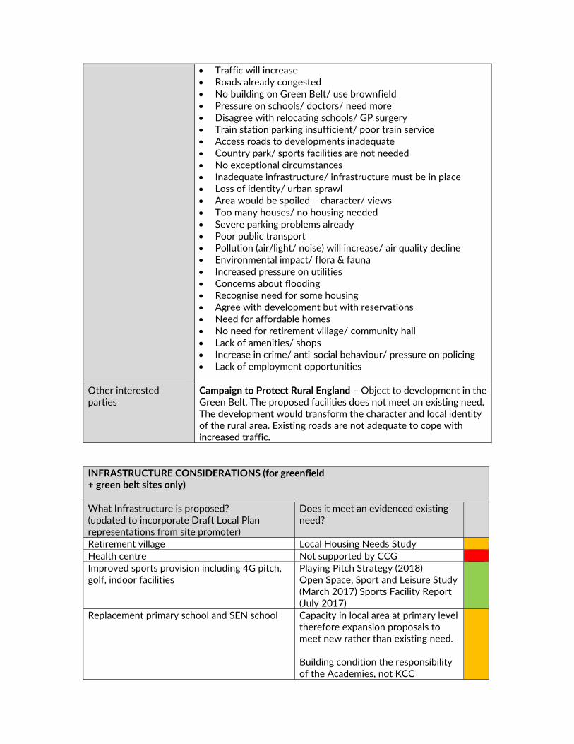
Traffic will increase Roads already congested No building on Green Belt/ use brownfield Pressure on schools/ doctors/ need more Disagree with relocating schools/ GP surgery Train station parking insufficient/ poor train service Access roads to developments inadequate Country park/ sports facilities are not needed No exceptional circumstances Inadequate infrastructure/ infrastructure must be in place Loss of identity/ urban sprawl Area would be spoiled – character/ views Too many houses/ no housing needed Severe parking problems already Poor public transport Pollution (air/light/ noise) will increase/ air quality decline Environmental impact/ flora & fauna Increased pressure on utilities Concerns about flooding Recognise need for some housing Agree with development but with reservations Need for affordable homes No need for retirement village/ community hall Lack of amenities/ shops Increase in crime/ anti‐social behaviour/ pressure on policing Lack of employment opportunities
Other interested parties
Campaign to Protect Rural England – Object to development in the Green Belt. The proposed facilities does not meet an existing need. The development would transform the character and local identity of the rural area. Existing roads are not adequate to cope with increased traffic.
INFRASTRUCTURE CONSIDERATIONS (for greenfield + green belt sites only) What Infrastructure is proposed? (updated to incorporate Draft Local Plan representations from site promoter)
Does it meet an evidenced existing need?
Retirement village Local Housing Needs Study Health centre Not supported by CCG Improved sports provision including 4G pitch, golf, indoor facilities
Playing Pitch Strategy (2018) Open Space, Sport and Leisure Study (March 2017) Sports Facility Report (July 2017)
Replacement primary school and SEN school Capacity in local area at primary level therefore expansion proposals to meet new rather than existing need. Building condition the responsibility of the Academies, not KCC

Employment floorspace Economic Needs Study Transport improvements Part of scheme design – not meeting
existing need
Country park Potentially welcome but not a priority – not an ‘evidenced need. KCC queries the need for such a park
Additional funding streams? Other sites available?
No other funding streams identified Existing sport facilities, schools and open space
Compensatory improvements in Green Belt?
Reference to Allotments & open space New country park ‐pedestrian and cycle links Children’s play area & outdoor gym
STAGE 2 SITE APPRAISAL CONCLUSION Is this site acceptable for the proposed development? NO
LOCAL PLAN STRATEGY ASSESSMENT Relevant Local Plan strategy Evidence
Housing – Greenfield site in the Green Belt
Infrastructure proposals not supported by relevant providers.
Does this site meet the relevant local plan strategy? NO
OVERALL CONCLUSION Do not include Land Use Developable area (ha) Density Site capacity Phasing


MX54a ‐ LAND BETWEEN BEECHENLEA LANE AND THE RAILWAY LINE, SWANLEY

SITE DELIVERABILITY ASSESSMENT
SHELAA ref MX54a SHELAA category 4 SHELAA conclusion Deliverable and developable SHELAA yield 593‐790 residential units SHELAA density 30‐40 DPH When will development be delivered?
1‐5 years
Will an existing use be lost? If yes, what?
Loss of agricultural field and buildings at the northern tip of the site.
Access requirements A new access would be required as well as an additional access to serve more than 50 units.
Green Belt strength & boundary issues
Strength: Strong Partially in weak performing parcel RA31
Viability issues There may be associated costs with building a new access road which includes a new bridge over the railway line
New infrastructure and community benefits
Public open space, including a leisure/cycle trail, viewpoint, allotments and children’s play areas. Land for an extension to the existing Downsview Primary School playing fields and provision of a drop off/pick up point for school‐children. Transport improvements. Land for a healthcare facility and community/local centre. Land for an indoor multipurpose sports hall and outdoor sports pitch (full size for football and/or rugby use). Provision/funding of a new pedestrian footbridge crossing over the railway
Input from technical specialists
KCC Highways
Other considerations Access issues need to be resolved. Deliverability summary Yellow – provision of social/community infrastructure benefits and
moderate/strongly performing Green Belt. STAGE 1 SITE APPRAISAL CONCLUSION Deliverability summary Yellow – provision of social/community infrastructure benefits and
moderate/strongly performing Green Belt. Key messages from SA Health centre
Bus stop Land Use Mixed Use – Residential, Community and Infrastructure Developable area (ha) 21.47 Density 40DPH Site capacity 400

Phasing 1‐5 years, 6‐10 years Overall conclusion
Include in plan, subject to further information
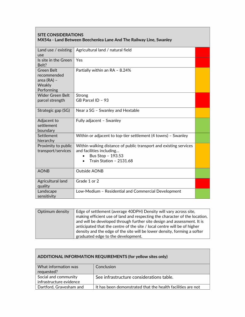
SITE CONSIDERATIONS MX54a ‐ Land Between Beechenlea Lane And The Railway Line, Swanley Land use / existing use
Agricultural land / natural field
Is site in the Green Belt?
Yes
Green Belt recommended area (RA) – Weakly Performing
Partially within an RA – 8.24%
Wider Green Belt parcel strength
Strong GB Parcel ID – 93
Strategic gap (SG) Near a SG – Swanley and Hextable
Adjacent to settlement boundary
Fully adjacent – Swanley
Settlement hierarchy
Within or adjacent to top‐tier settlement (4 towns) – Swanley
Proximity to public transport/services
Within walking distance of public transport and existing services and facilities including…
Bus Stop – 193.53 Train Station – 2131.68
AONB Outside AONB
Agricultural land quality
Grade 1 or 2
Landscape sensitivity
Low‐Medium – Residential and Commercial Development
Optimum density Edge of settlement (average 40DPH) Density will vary across site,
making efficient use of land and respecting the character of the location, and will be developed through further site design and assessment. It is anticipated that the centre of the site / local centre will be of higher density and the edge of the site will be lower density, forming a softer graduated edge to the development.
ADDITIONAL INFORMATION REQUIREMENTS (for yellow sites only) What information was requested?
Conclusion
Social and community infrastructure evidence
See infrastructure considerations table.
Dartford, Gravesham and It has been demonstrated that the health facilities are not

Swanley CCG – health facilities supported
supported in this location.
Transport modelling A Transport Assessment has not been submitted. KCC Highways have identified Access issues.
Sport England – sport facilities
It has not been demonstrated that a sports facility is required in this location.
Ecology and landscape assessment
Ecology and landscape assessment will be required
Network Rail response – is the bridge reasonable and feasible
It has not been demonstrated that the bridge is reasonable and/or feasible.
KCC Highways response – reasonable and supported
It is has been demonstrated that the impacts on the highway network are not supported.
SUMMARY OF CONSULTATION COMMENTS Site promoter Pro Vision – Support inclusion of the site.
Infrastructure providers Kent County Council (KCC) Highways – There is only one access
from Highlands Hill to the north. KCC Highways would be likely to raise objection to a development of over 300 homes served from a single access. New Barn Road and Leyden Hatch Lane are constrained in terms of width and not suited to any significant intensification of traffic. Traffic will therefore be distributed via the B258 Swanley Lane. This will lead to additional congestion and delays in Swanley Centre and contributions and mitigating measures will be required together with improvements to the Swanley Lane B258/Highlands Hill junction. The Park and Ride site shows a new access off Beechenlea Lane, however the pinch point to the south of the access is not suitable for the intensification of use by buses and cars to access the site. Also a park and ride site at this location will only be viable if a fast and frequent bus service is provided with journey time improvements when compared to car journeys. A new access is shown to the east of the site from Beechenlea Lane south of the railway bridge. Beechenlea Lane is narrow and not suited to any significant intensification of traffic flows and the railway bridge is weak with a weight limit.
DELIVERY Site has been promoted by Agent with support from the landowner The site promoter has indicated that there are no physical or viability constraints that would prevent the site commencing within years 1‐5 Site promotion team appointed and supporting studies provided / in preparation Conclusion Deliverable / Developable

Access –C Capacity –C Sustainability –B KCC Secondary Education ‐ A new 8FE secondary school will be needed for the students generated by the housing developments being proposed in the northern half of the district. Due to the distances involved, it would be sensible to site the new school in the Pedham Place development as it lies half way between Hartley and Swanley/Hextable as well as good transport links from the A20. With the amount of housing development being proposed in this Draft Local Plan, without a new 8FE school, KCC would have difficulty supporting housing development in the Swanley, Hextable, Pedham Place and Hartley areas. KCC Primary Education ‐ Up to 1450 new dwellings would generate 406 primary pupils. 406 pupil product is nearly a full 2FE primary school. There is currently some capacity in three of the primary schools in Swanley & Hextable. However, forecasts indicate that this capacity will be largely filled over the next few years. The pupil product from these developments must be accommodated in new provision. Downsview has been mentioned by the developer as the school that could be expanded. The location of much of the new housing would suggest that Downsview is the best option. However, the demand might better be met with a new 2FE primary school. KCC has no plans to move or relocate Broomhill Bank North Special School from Rowhill Road, Hextable. KCC retains the freehold. The disposition of the unoccupied Oasis Hextable school site is not yet determined. KCC retains the freehold. National Grid – National Grid prefers that buildings are not built directly beneath its overhead lines. This is for two reasons, the amenity of potential occupiers of properties in the vicinity of lines and because National Grid needs quick and easy access to carry out maintenance of its equipment to ensure that it can be returned to service and be available as part of the national transmission system. Such access can be difficult to obtain without inconveniencing and disturbing occupiers and residents, particularly where properties are in close proximity to overhead lines. Thames Water – Water Response ‐ The supply required for the proposed scale of development is a significant additional demand in the Water Resource area. Currently the mains that feed the Water Resource area are running close to capacity. Waste Response ‐ The scale of development/s is likely to require upgrades tot he wastewater network.
Statutory consultees KCC SuDS ‐ There are no surface water sewers within the vicinity. The underlying geology should be feasible for infiltration but there
may be constraints on specific portions of the site. This needs further investigation. There is a significant surface water overland flow path which traverses the northern and western portion of the site. It will be important to obtain ground investigation to inform masterplanning on this site. The overland flow path will need to be assessed and avoided if needed. SuDS features should not be located within this area if it is demonstrated to be a function of the site. KCC Heritage and Conservation ‐ Preliminary Heritage Assessment ‐ Potential for prehistoric remains in view of location within a valley system and presence of River Terrace Gravels on site. Mesolithic and Neolithic flint findspots are close to or within the site as well as find spots of Bronze Age and Roman date. Scale 3 - Significant archaeology could be dealt with through suitable conditions on a planning approval. Historic England - All sites included in the draft plan as potential housing or mixed development sites should be subject to a detailed heritage assessment prior to inclusion in the final draft Local Plan. Where negative impacts cannot be avoided or limited consideration should be given to reducing the quantum of development on the allocated site, or its removal if mitigation of the harm to heritage significance cannot be achieved. Site descriptions in Appendix A should be enhanced to identify heritage designations (listed buildings, scheduled monuments, registered parks and gardens, etc.) that may be affected by development of allocated sites. National Rail - There are between 4000 & 5000 units proposed around Swanley. NR estimate that around 14% of the working population would commute to Central London from this area. Swanley station is served by a frequent train service to both London Victoria and London Blackfriars with an average fast journey time of 36 minutes. In the future it is also due to get Thameslink services to London Bridge. Based on current forecasts, NR believes one additional vehicle will be required to meet on train passenger growth by 2024. The train operator is currently working on improvement plans for the station. However, if for example dedicated bus routes from the new housing developments were provided into the town, encouraging more commuting it is expected that further station enhancements would be required to cope with this increase in demand. The DfT is due to announce the winner of the next South Eastern franchise in Autumn 2018, which may include changes in rolling stock fleets.
Public including Town/Parish Councils
Swanley Town Council – Object to the proposal. The Town Council is confident that it has dismissed the case for exceptional circumstances, considering that all the proposed infrastructure is already being met, with increased infrastructure already being

planned, without the need to desecrate the Green Belt. We believe both pieces of land either side of the railway are unsuitable for development due to the important Green Belt protections, reinforced by Sevenoaks District Council’s own ARUP report, as well as its status as Grade 2 Very Good Quality agricultural land. Crockenhill Parish Council – These proposed developments far exceed the number of properties in Crockenhill, effectively making this another large village north‐east of Swanley, changing the overall landscape of the area and putting increased pressure on already inadequate infrastructure and facilities. One of Crockenhill Parish Council's other main concern is that all traffic from these developments would feed onto the M25/M20 feeder road – with implications for Crockenhill residents. More traffic on the feeder road affects access to Crockenhill via to B258, and would encourage traffic to seek alternative routes via Wested Lane/ Eynsford Road. Hextable Parish Council ‐ This huge development would impact greatly on Hextable particularly in regard to the possible access through Harrington’s Nursery at Five Wents junction with Main Road Hextable. Although there is no objection to the separate development of part of Harrington’ s Nursery site not connecting with the Beechenlea Lane site. General Public Main Issues (in order of frequency)– Object to the development No building on Green Belt/ use brownfield Roads already congested Pollution will increase/ air quality Traffic will increase No building on agricultural land Pressure on schools/ doctors/ more needed Loss of identity/ urban sprawl New surgery/ school/ leisure centre not needed Inadequate infrastructure/ infrastructure must be in place Park & rise not viable/ not needed No exceptional circumstances Too many houses/ no housing needed Area would be spoiled – character/ views Environmental impact/ flora & fauna Access roads to developments inadequate Pressure on emergency services/ ease of travel Severe parking problems already Development already rejected previously Train station parking insufficient/ poor train service Increase in crime/ anti‐social behaviour/ pressure on policing Recognise need for some housing Poor public transport Concerned about flooding
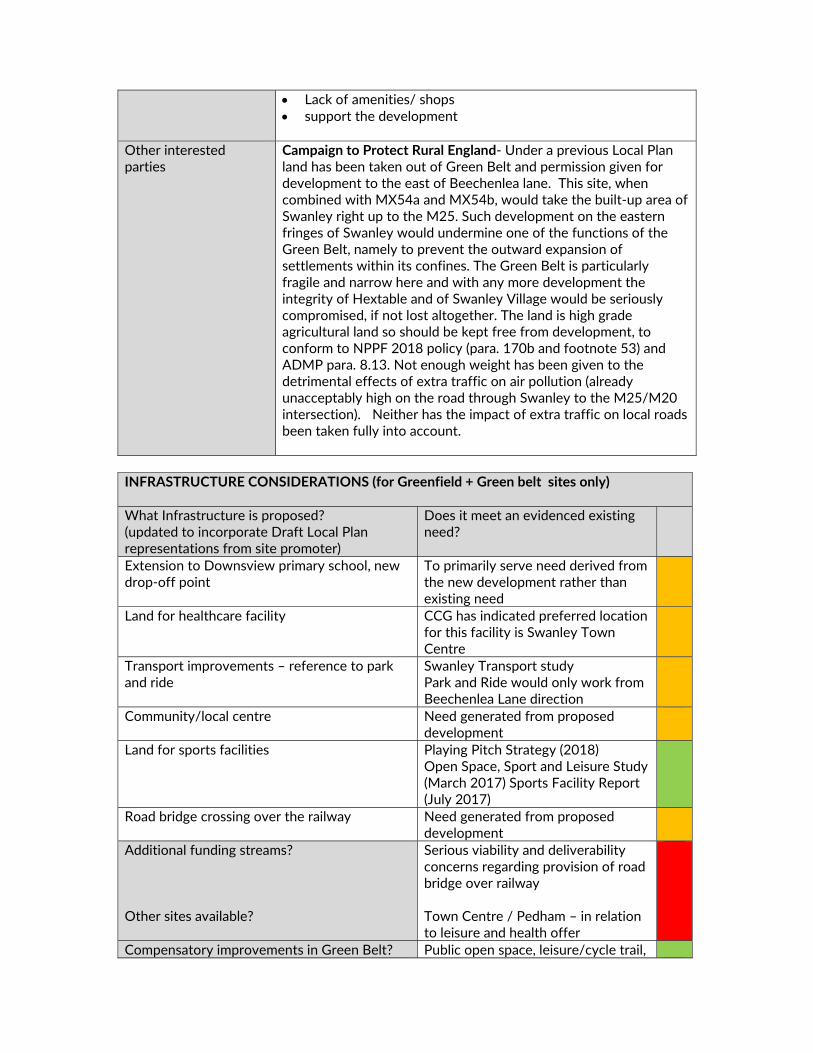
Lack of amenities/ shops support the development
Other interested parties
Campaign to Protect Rural England‐ Under a previous Local Plan land has been taken out of Green Belt and permission given for development to the east of Beechenlea lane. This site, when combined with MX54a and MX54b, would take the built‐up area of Swanley right up to the M25. Such development on the eastern fringes of Swanley would undermine one of the functions of the Green Belt, namely to prevent the outward expansion of settlements within its confines. The Green Belt is particularly fragile and narrow here and with any more development the integrity of Hextable and of Swanley Village would be seriously compromised, if not lost altogether. The land is high grade agricultural land so should be kept free from development, to conform to NPPF 2018 policy (para. 170b and footnote 53) and ADMP para. 8.13. Not enough weight has been given to the detrimental effects of extra traffic on air pollution (already unacceptably high on the road through Swanley to the M25/M20 intersection). Neither has the impact of extra traffic on local roads been taken fully into account.
INFRASTRUCTURE CONSIDERATIONS (for Greenfield + Green belt sites only) What Infrastructure is proposed? (updated to incorporate Draft Local Plan representations from site promoter)
Does it meet an evidenced existing need?
Extension to Downsview primary school, new drop‐off point
To primarily serve need derived from the new development rather than existing need
Land for healthcare facility CCG has indicated preferred location for this facility is Swanley Town Centre
Transport improvements – reference to park and ride
Swanley Transport study Park and Ride would only work from Beechenlea Lane direction
Community/local centre Need generated from proposed development
Land for sports facilities Playing Pitch Strategy (2018) Open Space, Sport and Leisure Study (March 2017) Sports Facility Report (July 2017)
Road bridge crossing over the railway Need generated from proposed development
Additional funding streams? Other sites available?
Serious viability and deliverability concerns regarding provision of road bridge over railway Town Centre / Pedham – in relation to leisure and health offer
Compensatory improvements in Green Belt? Public open space, leisure/cycle trail,

allotments and play areas STAGE 2 SITE APPRAISAL CONCLUSION Is this site acceptable for the proposed development? NO
LOCAL PLAN STRATEGY ASSESSMENT Relevant Local Plan strategy Evidence
Housing – Greenfield site in the Green Belt
Infrastructure proposals not supported by relevant providers.
Does this site meet the relevant local plan strategy? NO
OVERALL CONCLUSION Do not include Land Use Developable area (ha) Density Site capacity Phasing

MX54b ‐ LAND BETWEEN BEECHENLEA LANE AND THE RAILWAY LINE, SWANLEY
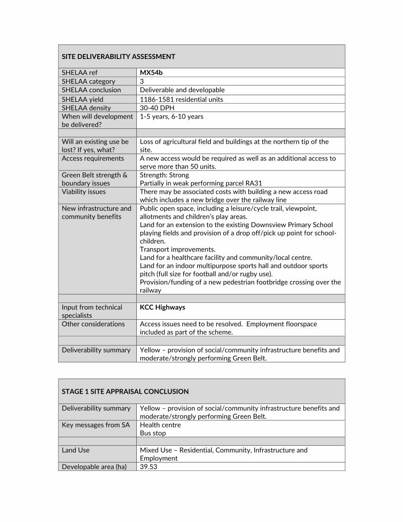
SITE DELIVERABILITY ASSESSMENT
SHELAA ref MX54b SHELAA category 3 SHELAA conclusion Deliverable and developable SHELAA yield 1186‐1581 residential units SHELAA density 30‐40 DPH When will development be delivered?
1‐5 years, 6‐10 years
Will an existing use be lost? If yes, what?
Loss of agricultural field and buildings at the northern tip of the site.
Access requirements A new access would be required as well as an additional access to serve more than 50 units.
Green Belt strength & boundary issues
Strength: Strong Partially in weak performing parcel RA31
Viability issues There may be associated costs with building a new access road which includes a new bridge over the railway line
New infrastructure and community benefits
Public open space, including a leisure/cycle trail, viewpoint, allotments and children’s play areas. Land for an extension to the existing Downsview Primary School playing fields and provision of a drop off/pick up point for school‐children. Transport improvements. Land for a healthcare facility and community/local centre. Land for an indoor multipurpose sports hall and outdoor sports pitch (full size for football and/or rugby use). Provision/funding of a new pedestrian footbridge crossing over the railway
Input from technical specialists
KCC Highways
Other considerations Access issues need to be resolved. Employment floorspace included as part of the scheme.
Deliverability summary Yellow – provision of social/community infrastructure benefits and
moderate/strongly performing Green Belt. STAGE 1 SITE APPRAISAL CONCLUSION Deliverability summary Yellow – provision of social/community infrastructure benefits and
moderate/strongly performing Green Belt. Key messages from SA Health centre
Bus stop Land Use Mixed Use – Residential, Community, Infrastructure and
Employment Developable area (ha) 39.53

Density 40DPH Site capacity 750 Phasing 1‐5 years, 6‐10 years Overall conclusion
Include in plan, subject to further information

SITE CONSIDERATIONS MX54b ‐ Land Between Beechenlea Lane And The Railway Line, Swanley Land use / existing use
Brownfield – 4.53% PDL
Is site in the Green Belt?
Yes
Green Belt recommended area (RA) – Weakly Performing
Partially within an RA – 4.48%
Wider Green Belt parcel strength
Strong GB Parcel ID – 93
Strategic gap (SG) Near a SG – Swanley and Hextable
Adjacent to settlement boundary
Fully adjacent – Swanley
Settlement hierarchy
Within or adjacent to top‐tier settlement (4 towns) – Swanley
Proximity to public transport/services
Within walking distance of public transport and existing services and facilities including…
Bus Stop – Less than 400m Train Station – More than 1km
AONB Outside AONB
Agricultural land quality
Grade 2
Landscape sensitivity
Low‐Medium – Residential and Commercial Development
Optimum density Edge of settlement (average 40DPH) Density will vary across site,
making efficient use of land and respecting the character of the location, and will be developed through further site design and assessment. It is anticipated that the centre of the site / local centre will be of higher density and the edge of the site will be lower density, forming a softer graduated edge to the development.
ADDITIONAL INFORMATION REQUIREMENTS (for yellow sites only) What information was requested?
Conclusion
Social and community infrastructure evidence
See infrastructure considerations table.

Dartford, Gravesham and Swanley CCG – health facilities supported
It has been demonstrated that the health facilities are not supported in this location.
Network Rail response – is the bridge reasonable and feasible
It has not been demonstrated that the bridge is reasonable and/or feasible.
Transport modelling A Transport Assessment has not been submitted. KCC Highways response Likely to raise an objection to a development of over 300
homes served from a single access.
SUMMARY OF CONSULTATION COMMENTS Site promoter Pro Vision – Support inclusion of the site.
Infrastructure providers Kent County Council (KCC) Highways‐ There is only one access
from Highlands Hill to the north. KCC Highways would be likely to raise objection to a development of over 300 homes served from a single access. New Barn Road and Leyden Hatch Lane are constrained in terms of width and not suited to any significant intensification of traffic. Traffic will therefore be distributed via the B258 Swanley Lane. This will lead to additional congestion and delays in Swanley Centre and contributions and mitigating measures will be required together with improvements to the Swanley Lane B258/Highlands Hill junction. The Park and Ride site shows a new access off Beechenlea Lane, however the pinch point to the south of the access is not suitable for the intensification of use by buses and cars to access the site. Also a park and ride site at this location will only be viable if a fast and frequent bus service is provided with journey time improvements when compared to car journeys. A new access is shown to the east of the site from Beechenlea Lane south of the railway bridge. Beechenlea Lane is narrow and not suited to any significant intensification of traffic flows and the railway bridge is weak with a weight limit. Access – C Capacity – C Sustainability –B
DELIVERY Site has been promoted by Agent with support from the landowner The site promoter has indicated that there are no physical or viability constraints that would prevent the site commencing within years 1‐5 Site promotion team appointed and supporting studies provided / in preparation Conclusion Deliverable / Developable

Thames Water ‐ Water Response ‐ The supply required for the proposed scale of development is a significant additional demand in the Water Resource area. Currently the mains that feed the Water Resource area are running close to capacity. Waste Response ‐ The scale of development/s is likely to require upgrades to the wastewater network. KCC Primary Education ‐ Up to 1450 new dwellings would generate 406 primary pupils. 406 pupil product is nearly a full 2FE primary school. There is currently some capacity in three of the primary schools in Swanley & Hextable. However, forecasts indicate that this capacity will be largely filled over the next few years. The pupil product from these developments must be accommodated in new provision. Downsview has been mentioned by the developer as the school that could be expanded. The location of much of the new housing would suggest that Downsview is the best option. However, the demand might better be met with a new 2FE primary school. KCC would be happy to talk to the developer and SDC about options for the Swanley Planning Area. KCC Secondary Education ‐ A new 8FE secondary school will be needed for the students generated by the housing developments being proposed in the northern half of the district. Due to the distances involved, it would be sensible to site the new school in the Pedham Place development as it lies half way between Hartley and Swanley/Hextable as well as good transport links from the A20. With the amount of housing development being proposed in this Draft Local Plan, without a new 8FE school, KCC would have difficulty supporting housing development in the Swanley, Hextable, Pedham Place and Hartley areas. National Rail ‐ There are between 4000 & 5000 units proposed around Swanley. NR estimate that around 14% of the working population would commute to Central London from this area. Swanley station is served by a frequent train service to both London Victoria and London Blackfriars with an average fast journey time of 36 minutes. In the future it is also due to get Thameslink services to London Bridge. Based on current forecasts, NR believes one additional vehicle will be required to meet on train passenger growth by 2024. The train operator is currently working on improvement plans for the station. However, if for example dedicated bus routes from the new housing developments were provided into the town, encouraging more commuting it is expected that further station enhancements would be required to cope with this increase in demand. The DfT is due to announce the winner of the next South Eastern franchise in Autumn 2018, which may include changes in rolling stock fleets

Statutory consultees KCC SuDS ‐ There are no surface water sewers within the vicinity. The underlying geology should be feasible for infiltration but there may be constraints on specific portions of the site. This needs further investigation. There is a significant surface water overland flow path which traverses the northern and western portion of the site. It will be important to obtain ground investigation to inform masterplanning on this site. The overland flow path will need to be assessed and avoided if needed. SuDS features should not be located within this area if it is demonstrated to be a function of the site. KCC Heritage and Conservation ‐ Preliminary Heritage Assessment ‐ Potential for prehistoric remains in view of location within a valley system and presence of River Terrace Gravels on site. Mesolithic and Neolithic flint findspots are close to or within the site as well as findspots of Bronze Age and Roman date. Scale 3 ‐ Significant archaeology could be dealt with through suitable conditions on a planning approval. Historic England ‐ All sites included in the draft plan as potential housing or mixed development sites should be subject to a detailed heritage assessment prior to inclusion in the final draft Local Plan. Where negative impacts cannot be avoided or limited consideration should be given to reducing the quantum of development on the allocated site, or its removal if mitigation of the harm to heritage significance cannot be achieved. Site descriptions in Appendix A should be enhanced to identify heritage designations (listed buildings, scheduled monuments, registered parks and gardens, etc.) that may be affected by development of allocated sites.
Public including Town/Parish Councils
Swanley Town Council‐ Object to the proposal. The Town Council is confident that it has dismissed the case for exceptional circumstances, considering that all the proposed infrastructure is already being met, with increased infrastructure already being planned, without the need to desecrate the Green Belt. We believe both pieces of land either side of the railway are unsuitable for development due to the important Green Belt protections, reinforced by Sevenoaks District Council’s own ARUP report, as well as its status as Grade 2 Very Good Quality agricultural land. Crockenhill Parish Council – These proposed developments far exceed the number of properties in Crockenhill, effectively making this another large village north‐east of Swanley, changing the overall landscape of the area and putting increased pressure on already inadequate infrastructure and facilities. One of Crockenhill Parish Council's other main concern is that all traffic from these developments would feed onto the M25/M20 feeder road – with implications for Crockenhill residents. More traffic on the feeder

road affects access to Crockenhill via to B258, and would encourage traffic to seek alternative routes via Wested Lane/ Eynsford Road. Hextable Parish Council ‐ This huge development would impact greatly on Hextable particularly in regard to the possible access through Harrington’s Nursery at Five Wents junction with Main Road Hextable. Although there is no objection to the separate development of part of Harrington’ s Nursery site not connecting with the Beechenlea Lane site. General Public Main Issues (in order of frequency)– Object to the development No building on Green Belt/ use brownfield Pollution will increase/ air quality Roads already congested Traffic will increase No building on agricultural land Loss of identity/ urban sprawl Pressure on schools/ doctors/ more needed New surgery/ school/ leisure centre not needed Inadequate infrastructure/ infrastructure must be in place Park & ride not viable/ not needed No exceptional circumstances Area would be spoiled – character/views Too many houses/ no housing need Environmental impact/ flora & fauna Access roads to development inadequate Pressure on emergency services/ ease of travel Severe parking problems already/ parking would need to be
addressed Development already rejected previously Train station parking insufficient/ poor train service Poor public transport already/ will be made worse Concerns about flooding Increase in crime/ anti‐social behaviour/ pressure on policing Recognise need for some housing Lack of amenities/ shops Support the development
Other interested parties
Campaign to Protect Rural England – Under a previous Local Plan land has been taken out of Green Belt and permission given for development to the east of Beechenlea lane. This site, when combined with MX54a and MX54b, would take the built‐up area of Swanley right up to the M25. Such development on the eastern fringes of Swanley would undermine one of the functions of the Green Belt, namely to prevent the outward expansion of settlements within its confines. The Green Belt is particularly fragile and narrow here and with any more development the integrity of Hextable and of Swanley Village would be seriously compromised, if not lost altogether. The land is high grade agricultural land so should be kept free from development, to

conform to NPPF 2018 policy (para. 170b and footnote 53) and ADMP para. 8.13. Not enough weight has been given to the detrimental effects of extra traffic on air pollution (already unacceptably high on the road through Swanley to the M25/M20 intersection). Neither has the impact of extra traffic on local roads been taken fully into account.
INFRASTRUCTURE CONSIDERATIONS (for greenfield + green belt sites only) What Infrastructure is proposed? (updated to incorporate Draft Local Plan representations from site promoter)
Does it meet an evidenced existing need?
Extension to Downsview primary school, new drop‐off point
To primarily serve need derived from the new development rather than existing need
Land for healthcare facility CCG has indicated preferred location for this facility is Swanley Town Centre
Transport improvements – reference to park and ride
Swanley Transport study Park and Ride would only work from Beechenlea Lane direction
Community/local centre Need generated from proposed development
Land for sports facilities Playing Pitch Strategy (2018) Open Space, Sport and Leisure Study (March 2017) Sports Facility Report (July 2017)
Road bridge crossing over the railway Need generated from proposed development
Additional funding streams? Other sites available?
Serious viability and deliverability concerns regarding provision of road bridge over railway Town Centre / Pedham – in relation to leisure and health offer
Compensatory improvements in Green Belt?
Public open space, leisure/cycle trail, allotments and play areas
STAGE 2 SITE APPRAISAL CONCLUSION Is this site acceptable for the proposed development? NO
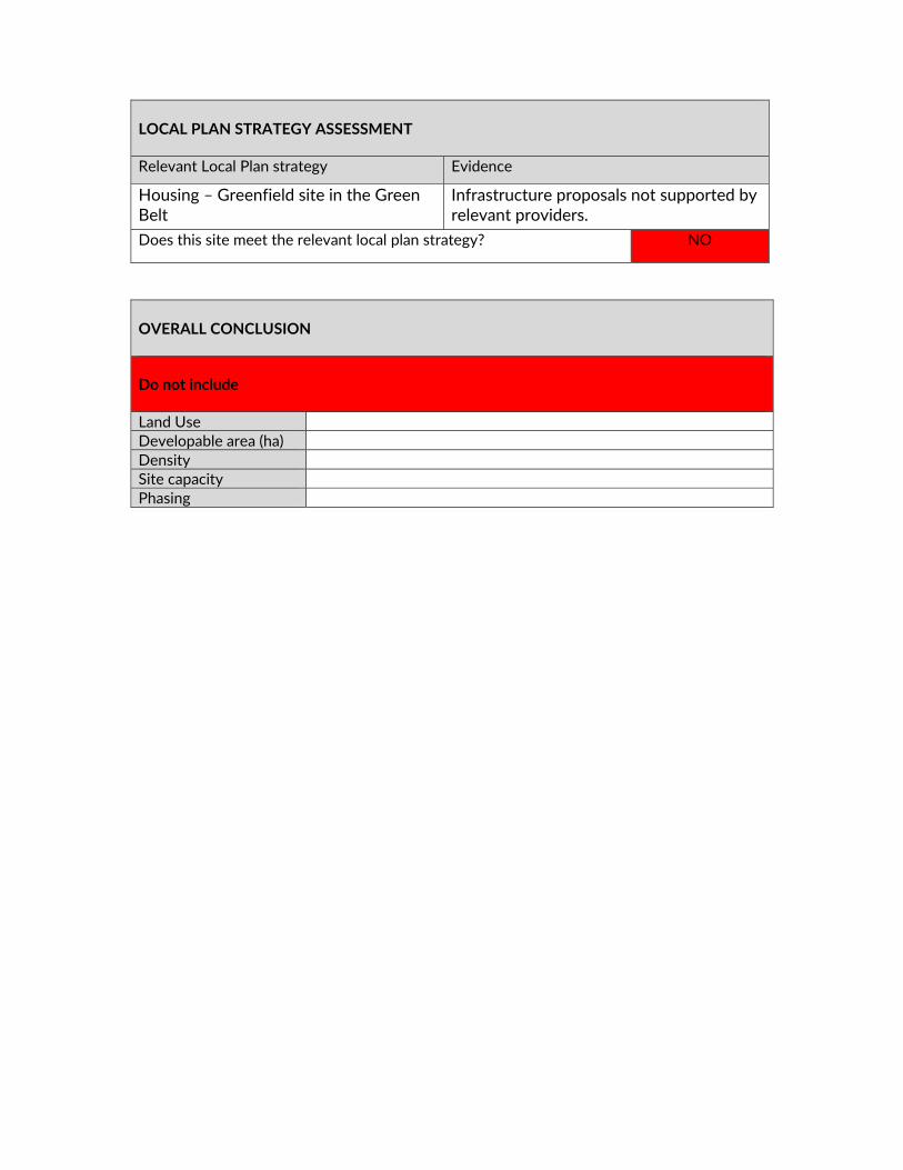
LOCAL PLAN STRATEGY ASSESSMENT Relevant Local Plan strategy Evidence
Housing – Greenfield site in the Green Belt
Infrastructure proposals not supported by relevant providers.
Does this site meet the relevant local plan strategy? NO
OVERALL CONCLUSION Do not include Land Use Developable area (ha) Density Site capacity Phasing