Literature Review - Percentile Groundwater Indicator Documents/Percentile Groundwater... · 1.0...
21
1 Nottawasaga Valley Conservation Authority Percentile Groundwater Indicator Literature Review Prepared by Ryan Post February 18, 2013 Nottawasaga Valley Conservation Authority 8195 8th Line, Utopia, ON, L0M 1T0 705-424-1479 www.nvca.on.ca If you require this document in an alternative format, contact NVCA at 705-424-1479 or [email protected].
Transcript of Literature Review - Percentile Groundwater Indicator Documents/Percentile Groundwater... · 1.0...

1
Nottawasaga Valley Conservation Authority
Percentile Groundwater Indicator Literature Review
Prepared by Ryan Post
February 18, 2013
Nottawasaga Valley Conservation Authority 8195 8th Line, Utopia, ON, L0M 1T0
705-424-1479 www.nvca.on.ca
If you require this document in an alternative format,contact NVCA at 705-424-1479 or [email protected].

2
Table of Contents 1.0 Introduction ............................................................................................................................................. 3 2.0 Groundwater drought indicators .............................................................................................................. 3
2.1 Jacques Whitford Method ................................................................................................................... 3 2.2 Percentile method ............................................................................................................................... 4 2.3 Other groundwater level indicator methodologies: Groundwater Resource Index (GRI) ................... 5
3.0 Summary of groundwater drought indicators in Canada- provincial level .............................................. 5 3.1 Alberta ................................................................................................................................................. 5 3.2 British Columbia .................................................................................................................................. 5 3.3 Manitoba ............................................................................................................................................. 5 3.4 New Brunswick .................................................................................................................................... 6 3.5 Newfoundland: .................................................................................................................................... 6 3.6 Nova Scotia ......................................................................................................................................... 6 3.7 Prince Edward Island .......................................................................................................................... 7 3.8 Saskatchewan ..................................................................................................................................... 7
4.0 Summary of groundwater drought indicators in the United States of America- state level .................... 7 4.1 Role of the Individual State ................................................................................................................. 7 4.2 Role of the United States Geological Survey .................................................................................... 10 4.3 Summary of individual states and groundwater indicator use .......................................................... 11
4.3.1 Alabama ..................................................................................................................................... 11 4.3.2 Arizona ....................................................................................................................................... 12 4.3.3 Connecticut ................................................................................................................................ 12 4.3.4 Georgia ...................................................................................................................................... 13 4.3.5 Maryland .................................................................................................................................... 14 4.3.6 Massachusetts ........................................................................................................................... 14 4.3.7 New Jersey ................................................................................................................................ 15 4.3.8 New York .................................................................................................................................... 15 4.3.9 Pennsylvania .............................................................................................................................. 16 4.3.10 Rhode Island ............................................................................................................................ 16 4.3.11 Virginia ..................................................................................................................................... 17
5.0 Summary and Recommendations ......................................................................................................... 18 5.1 Ontario recommendations ................................................................................................................. 19 5.2 Next Steps ......................................................................................................................................... 19
6.0 References ............................................................................................................................................ 21 List of figures: Figure 1: USGS colour codes of groundwater percentiles. ......................................................................... 11 Figure 2: Connecticut Drought Preparedness and Response Plan Drought Matrix. .................................. 13 Figure 3: Drought indicators for Virginia , September 25, 2012 (http://www.deq.virginia.gov/Programs/Water/WaterSupplyWaterQuantity/Drought.aspx) ........................ 17 List of tables Table 1: Summary of individual state drought management/response document and the use of groundwater as a drought indicator. ............................................................................................................. 8 Table 2: Summary of Key Groundwater Monitoring Parameters per Jurisdiction for Drought Indicators. .. 18
3
1.0 Introduction Ontario Low Water Response (OLWR) is a mitigation strategy, intended to reduce the socioeconomical and environmental effects of low water (Ontario Ministry of Natural Resources et al., 2010). The Ontario Low Water Response Program defines drought as weather and low water conditions characterized by one or more of the following:
a) Below normal precipitation for an extended period of time (3 months or more), potentially combined with high rates of evaporation, can lower lake levels, streamflows and/or baseflows and reduce soil moisture and/or groundwater storage; b) Streamflows are at the minimum required to sustain aquatic life while meeting only high priority demands for water; significant decrease in water level of local wells to the point where they become dry; surface water in storage allocated to maintain minimum streamflows; and c) Socioeconomic effects occurring on individual properties and extending to larger areas of a watershed or beyond.
The three levels of the OLWR low water consist of: Level I-conservation; Level II- conservation and restriction; and Level III- conservation, restriction, and regulation. Drought indicators can be defined as a set of variables that characterize the magnitude, duration, severity, and spatial extent of drought which allows for comparison of different areas, countries and regions on different conditions and aspects (Steinemann and Cavalcanti, 2006). Precipitation and stream flow are the currently used indicators to determine the low water levels for individual watersheds. To date, a groundwater indicator has not been used in the Ontario Low Water Response system; however, it is presently being explored (Ontario Ministry of the Environment, 2008). Other jurisdictions, notably several individual states in the United States of America, have integrated a groundwater drought indicator into their drought defining process through the ubiquitous application of the percentile method. The percentile method has also been recommended as the preferred groundwater indicator methodology by the MNR-MOE-CA Groundwater Low Water Indicator Team. (In this report, drought and low water are used based on the jurisdiction’s definition; however, are herein used interchangeably.) The objective of this report was to complete a desktop literature review of:
1) Summary of the various groundwater drought indicators, focusing on the Percentile Method-a standard statistical method, the Jacques Whitford Method developed by the MNR, and other methods- the Groundwater Resource Index,
2) A summary of groundwater monitoring across Canada and the US and how groundwater is incorporated in drought warning/management across the Canada and the US where applicable, and
3) Description of groundwater indicators used at the provincial or state level in Canada and the US, respectively along with the associated data requirements and the statistical analysis employed, which is limited to the percentile method.
2.0 Groundwater drought indicators This report focuses on a literature review of the percentile method used as a groundwater level indicator. However, other groundwater level indicators have been developed with limited to no North American application. A summary of the various groundwater drought indicators, focusing on the Percentile Method-a standard statistical method, the Jacques Whitford Method developed by the MNR, and other methods- the Groundwater Resource Index is presented below.
2.1 Jacques Whitford Method Jacques Whitford (2007) completed a groundwater indicator study for the MNR in which a methodology for evaluating groundwater data for the OLWR program was developed referred to as the Jacques Whitford method. To apply it, calendar monthly average water levels are compared against two ‘triggers’ to determine low water conditions. The trigger values were determined as follows:
• The Trigger I value is defined as the historical mean groundwater level in a month minus the standard deviation of historical daily average water levels for that month. Thus, there are 12 Trigger I values: one corresponding to each month of the year;
4
• The Trigger II value is selected based on the depth of the well, properties of the aquifer, and characteristics of the groundwater users that depend on the resources monitored by the well; or, absent this information, the lowest daily average level that has been observed in the well. The lowest valid daily average level ever recorded was used as the Trigger II.
The corresponding groundwater OLWR Level I conditions occur when the 30-day average water level falls below the Trigger I value for that month. Level II conditions occur when the 30-day average water level is below the Trigger I value for 3 months in a row or the daily average water level is below Trigger II for one day in the previous month. Level III conditions occur when the 30-day average water level is below the Trigger II value.
2.2 Percentile method The standard statistical method, a percentile is a statistic that gives the relative standing of a numerical data point when compared to all other data points in a distribution. A percentile is a value on a scale of 0 to 100 that indicates the percentage of observations that is equal to or below it. It can be defined as the pth percentile of a distribution is a number such that approximately p percent (p%) of the values in the distribution are equal to or less than that number. So, if ‘28’ is the 80th percentile of a larger batch of numbers, 80% of those numbers are less than or equal to 28. Percentiles can be estimated from N measurements as follows: for the pth percentile, set p(N+1) equal to k + d for k an integer, and d, a fraction greater than or equal to 0 and less than 1. Percentiles are estimated from N measurements as follows:
For 0 < k < N, Y(p) = Y[k] + d(Y[k+1] - Y[k]) For k = 0, Y(p) = Y[1] For k = N, Y(p) = Y[N]
Detailed information on the percentile method can be found at: http://www.itl.nist.gov/div898/handbook/prc/section2/prc252.htm. The proposed MNR groundwater low water indicator uses the percentile method and is calculated on a monthly basis, using the available historical data for a particular well (MOE, 2008). Thus, twelve sets of triggers are developed for each well, one set of triggers corresponding to each month of the year. The trigger levels are defined as the following:
• 100th percentile equals maximum water level on record • 50th percentile equals median conditions • 25th percentile equals Trigger 1 (Level 1) • 10th percentile equals Trigger 2 (Level 2) • 5th percentile equals Trigger 3 (Level 3) • 0th percentile equals minimum water level on record
Level I conditions occur when the 30-day average water level falls below the Trigger 1 value for that month. Level II conditions occur when the 30-day average water level falls below the Trigger 2 value for that month. Level III conditions occur when the 30-day average water level falls below the Trigger 3 value for that month. It is noted that the MOE (2008) did not outline the length of dataset nor the percent completion. The Upper Thames River Conservation Authority (2008) summarized the following regarding the Percentile and the Jacques Whitford method: The Percentile Method is a standard groundwater evaluation tool in the United States being used by the United States Geological Survey (USGS) but they do have long-term data to support this tool. The JW Method was developed due to the lack of long-term data and is very defensible statistically. Consideration should be made to apply a standard method for both surface and groundwater. The
5
Percentile Method would ensure a simpler and more consistent standard to compare both groundwater and surface water conditions.
2.3 Other groundwater level indicator methodologies: Groundwater Resource Index (GRI) Other groundwater level indicator methodologies is limed to the Groundwater Resource Index (GRI). Recently developed by Mendicino et al. (2008), this index is based on a normal distribution of the simulated groundwater storage in porous media at a site. To date, the GRI has been employed only in academic evaluation where the performance has been tested by Mendicino et al. (2008) with 40-years of simulated data. The simulated data were generated by a hydrological model which used: precipitation, air temperature, and air pressure data as driving forces. They compared the GRI with the Standard Precipitation Index (SPI) of 6-, 12-, and 24-months. They found that the GRI was a better indicator for droughts in the Mediterranean area than the SPI (Wanders et al., 2010). The GRI has not been evaluated in North America and is not further elaborated on in this report. 3.0 Summary of groundwater drought indicators in Canada- provincial level Drought determination and declaration is completed at the province level in Canada. This includes 1) the method employed for the indicator, e.g. percentiles, and 2) the use of groundwater as an indicator. Below is a summary of the use of groundwater for drought management purposes at the provincial level, synthesized from provincial drought websites (where found) and personal communication with individuals involved with the drought programs. Groundwater and drought management information was unable to be obtained for Quebec and for the territories. It is noted that only Manitoba is currently using groundwater as a supplemental drought indicator.
3.1 Alberta Information on the Alberta Agriculture Drought Risk Management Plan can be found at http://www1.agric.gov.ab.ca/$department/deptdocs.nsf/all/ppe3883. The Alberta Agriculture Drought Risk Management Plan does not use groundwater as an indicator of drought but does collect information on precipitation, temperature and soil moisture. However, Alberta has a Groundwater Observation Well Network (GOWN) consisting of a network of groundwater monitoring wells located in various aquifers throughout the province. Most of these wells are equipped to continually record groundwater levels. In addition, many of these wells are sampled for water quality analysis. Commencing with three wells in 1957, the network now has over 250 GOWN wells, with about 200 wells being monitored for levels and 160 wells for quality.
3.2 British Columbia The provincial drought plan acknowledges that low stream flows and reduced recharge can impact groundwater levels, which in turn is associated with hydrological drought. Hence, groundwater levels are identified as a supplementary drought indicator; however, no groundwater indicators are identified. It is noted that drought preparedness and response actions outline a need to progressively increase the frequency of monitoring water levels in priority aquifers as a drought intensifies and to publicly communicate that information. The Provincial Observation Well Network provides the possible sites for monitoring groundwater levels. Website: http://www.env.gov.bc.ca/wsd/plan_protect_sustain/groundwater
3.3 Manitoba Manitoba Conservation and Water Stewardship Department has developed a groundwater indicator based on the lower percentile of groundwater levels for the Manitoba Drought Management Strategy, which is in a draft stage and under review. Given the response time in groundwater, the groundwater indicator is to be used as a secondary indicator, supplementary of the principal indictors (streamflow and precipitation).
6
The percentiles are based on an analysis of historical groundwater records available at groundwater monitoring stations in each aquifer across southern Manitoba. Five monitoring wells across southern Manitoba were used to determine the groundwater indicator. Three wells are situated in unconfined aquifer settings; one is completed in a confined aquifer; and one in a transitional aquifer (between unconfined and confined; Abul Kashem, pers. comm., August 2012). A minimum of 37 years of data were used for each station. The historical database was used to calculate the 0.1th, 5th and 25th percentile of groundwater level for each month of the year. For example, the 0.1th percentile is the water level that occurs less than or equal to 0.1% of time or, conversely, is the water level amount that is exceeded 99.9% of the time. In calculating the indicator, the average groundwater level in the month in question was compared to the lowest of the monthly 0.1th, 5th and 25th percentiles with the following thresholds:
• Normal: Monthly groundwater level is greater than the lowest of the monthly 25th percentiles.
• Moderately Dry: Monthly groundwater level is between the lowest of the monthly 25th percentiles and the lower of the monthly 5th percentiles.
• Severely Dry: Monthly groundwater level is between the lowest of the monthly 5th percentiles and the lower of the monthly 0.1th percentiles.
• Extremely Dry: Monthly groundwater level is less than or equal to the lowest of the monthly 0.1th percentiles.
Website: http://www.gov.mb.ca/conservation/waterstewardship/water_quality/wells_groundwater/index.html
3.4 New Brunswick New Brunswick does not use groundwater as a drought indicator (Nadine Caissie Long, pers. comm., September 2012). Presently, New Brunswick utilizes the National Climatic Data Centre for drought awareness (http://www.ncdc.noaa.gov/temp-and-precip/drought/nadm/nadm-maps.php?lang=en&year=2012&month=7). New Brunswick monitors groundwater levels at a number of provincial monitoring wells and releases monthly reports on the levels against the monthly maximum and minimum recorded levels. This data is also used to make a decision on water conservation issues. These reports can be found at: http://www2.gnb.ca/content/gnb/en/departments/elg/environment/content/water/content/water_quantity.html.
3.5 Newfoundland: Newfoundland presently does not have drought indicators for groundwater. Further, Newfoundland is in the process of developing a groundwater monitoring network.
3.6 Nova Scotia Nova Scotia does not complete drought indicator analyses for groundwater. However, all groundwater level data is published on a quarterly basis showing historical highs/lows for comparison on the graphs. In addition, Nova Scotia Environment publishes an annual report that includes a statistical analysis of groundwater levels over time using a Mann-Kendall trend analysis to look for statistically significant trends over the long-term, rather than short duration droughts (John Drage, pers. comm., August 2012).
• Nova Scotia observation well network webpage can be found here: http://www.gov.ns.ca/nse/groundwater/groundwaternetwork.asp
• The current groundwater level graphs can be found here: http://www.gov.ns.ca/nse/groundwater/groundwaternetworkwells.asp
7
• The most recent annual observation well report can be found here: http://www.gov.ns.ca/nse/groundwater/docs/GroundwaterObservationWellNetwork2011Report.pdf
Website: www.gov.ns.ca/nse/groundwater/
3.7 Prince Edward Island PEI does not have a groundwater drought indicator or a drought response plan (Barry Thompson, pers. comm., August 2012). It is noted that PEI tracks groundwater levels and displays historical maximums and minimums along with current levels from 13 groundwater observation wells located across PEI. (http://www.gov.pe.ca/environment/groundwater-levels).
3.8 Saskatchewan Saskatchewan presently does not have a drought response plan nor does it have a drought assessment or drought indicators using groundwater information (Nolan Shaheen, pers. comm., August 2012). It is noted that Saskatchewan does have an observation well network of 70 wells equipped with continuous water level recorders. The earliest wells were established in 1964 with the bulk of the well established in the 1960’s through the 1970’s with additional wells continued to be added through to the early 1990’s. The objective of the network is to measure natural fluctuations in groundwater levels in areas that are remote from influences of groundwater production and artificial recharge. Individual hydrographs illustrating monthly mean water levels and completion records for the wells are located at http://www.swa.ca/WaterManagement/Groundwater.asp?type=ObservationWells# 4.0 Summary of groundwater drought indicators in the United States of America- state level With the exception of the U.S. Drought Monitor (http://droughtmonitor.unl.edu/monitor.html), there is no "umbrella" organization for monitoring/recognizing drought conditions in the individual states. The Drought Monitor (DM) is a collaborative product produced weekly by the U.S. Department of Agriculture, NOAA/National Weather Service, NOAA/National Climatic Data Center, and the National Drought Mitigation Center at the University of Nebraska-Lincoln. A number of other Federal agencies participate in the preparation of the DM, including the United States Geological Survey (USGS), but most do so by providing current data from their various monitoring programs.
4.1 Role of the Individual State Drought determination and declaration is completed at the individual state level. This includes 1) the method employed for the indicator, and 2) the use of groundwater as an indicator. Hence, this individual state drought responsibility results in states such as Colorado, Kansas, Wyoming, and others not having groundwater as an indicator. Further, this definition of roles and responsibilities also results in the individual states, e.g. Pennsylvania and New Jersey, assigning different values to drought levels. Although the individual states are able to define the drought levels and indicators, the percentile method is used ubiquitously throughout the states where groundwater is used as an indicator as the individual states use the federally consistent data generated by the USGS for groundwater levels. It is noted that almost every individual state has a drought management document, located collectively at the National Drought Mitigation Centre (http://www.drought.unl.edu/Planning/PlanningInfobyState/DroughtandManagementPlans.aspx). Table 1 summarizes the year of the drought management plan release, if groundwater is used as an indicator and the link to the plan and the associated USGS website for groundwater levels. It is noted that, where the drought management plan was located, 12 states use groundwater as an indicator.

8
Table 1: Summary of individual state drought management/response document and the use of groundwater as a drought indicator. It is noted that not all drought management plans or drought response sites for the 50 States of the USA were able to be located for this literature review.
State Ground water indicator: Y/N
Link to drought management plan or State Drought Management and Response Sites
Year of drought response plan
USGS groundwater link
Alabama Y http://www.adeca.alabama.gov/Divisions/owr/Documents/20040422_ALDroughtPlan_DraftFinal.pdf
2004 http://groundwaterwatch.usgs.gov/StateMaps/AL.html
Arizona Y http://www.azwater.gov/AzDWR/StatewidePlanning/Drought/documents/operational_drought_plan.pdf
2004 http://groundwaterwatch.usgs.gov/StateMaps/AZ.html
Colorado N http://cwcbweblink.state.co.us/WebLink/ElectronicFile.aspx?docid=145453&searchid=8b0c8c76-e047-4f46-8e09-7237713bddeb&dbid=0
2010 http://groundwaterwatch.usgs.gov/StateMaps/CO.htm
Connecticut Y http://www.drought.state.ct.us/drtwkpln.pdf
2003 http://groundwaterwatch.usgs.gov/StateMaps/CT.html
Florida N http://www.georgiaplanning.com/watertoolkit/Documents/WaterConservationDroughtManagement/DroughtMgtPlanFinal03.pdf
2007 http://groundwaterwatch.usgs.gov/StateMaps/FL.html
Georgia Y http://www.georgiaplanning.com/watertoolkit/Documents/WaterConservationDroughtManagement/DroughtMgtPlanFinal03.pdf
2003 http://groundwaterwatch.usgs.gov/StateMaps/GA.html
Hawaii N http://hawaii.gov/dlnr/drought/preparedness/HDP2b.pdf
2005 http://groundwaterwatch.usgs.gov/StateMaps/HI.html
Idaho N http://www.idwr.idaho.gov/News/drought/PDFs/Drought%20Plan.pdf
2001 http://groundwaterwatch.usgs.gov/StateMaps/ID.html
Illinois N http://www.isws.illinois.edu/hilites/drought/archive/2011/docs/St_Ill_Drought_Plan_2011.pdf
2011 http://groundwaterwatch.usgs.gov/StateMaps/IL.html
Indiana Y http://www.in.gov/dnr/files/watshplan.pdf 2009 http://groundwaterwatch.usgs.gov/StateMaps/IN.html
Kansas N http://www.kwo.org/reports_publications/Drought/rpt_drought_op_plan_gdrt_draft_withapendi_062912_dc_kf.pdf
2012 http://groundwaterwatch.usgs.gov/StateMaps/KS.html
Kentucky N http://www.in.gov/dnr/files/wa-kentuckydroughtplan.pdf http://www.crh.noaa.gov/jkl/?n=drought
2008 http://groundwaterwatch.usgs.gov/StateMaps/KY.html
Louisiana N http://www.ohsep.louisiana.gov/hazards/droughtindex.htm
http://groundwaterwatch.usgs.gov/StateMaps/LA.html
Maryland Y http://www.mde.state.md.us/assets/document/drought/droughtreport.pdf
2000 http://groundwaterwatch.usgs.gov/State

9
Maps/MD.html Massachusetts
Y http://www.mass.gov/dcr/watersupply/rainfall/drought.htm
2001 http://groundwaterwatch.usgs.gov/StateMaps/MA.html
Michigan N http://seca.unl.edu/web_archive/StateDroughtPlans/DroughtPlans/MI_1988.pdf
1988 http://groundwaterwatch.usgs.gov/StateMaps/MI.html
Minnesota N http://files.dnr.state.mn.us/natural_resources/climate/drought/drought_plan_matrix.pdf
2009 http://groundwaterwatch.usgs.gov/StateMaps/MN.html
Missouri N http://www.dnr.mo.gov/pubs/WR69.pdf
2002 http://groundwaterwatch.usgs.gov/StateMaps/MO.html
Montana N http://montanadma.org/sites/default/files/Volume%20X_Drought%20Plan.pdf
1995 http://groundwaterwatch.usgs.gov/StateMaps/MT.html
Nebraska N http://carc.agr.ne.gov/docs/NebraskaDrought.pdf
2000 http://groundwaterwatch.usgs.gov/StateMaps/NE.html
New Hampshire
N http://des.nh.gov/organization/commissioner/pip/publications/wd/documents/nhdes-wrb-90-1.pdf
1990 http://groundwaterwatch.usgs.gov/StateMaps/NH.htm
New Jersey Y http://www.njdrought.org/
http://groundwaterwatch.usgs.gov/StateMaps/NJ.html
New Mexico N http://weather.nmsu.edu/drought/Drought-plan1112002/Volume-2.pdf
2002 http://groundwaterwatch.usgs.gov/StateMaps/NM.html
New York Y http://www.dec.ny.gov/lands/5011.html
http://groundwaterwatch.usgs.gov/StateMaps/NY.html
North Carolina
N http://www.ncdrought.org/
http://groundwaterwatch.usgs.gov/StateMaps/NC.html
Ohio N http://ema.ohio.gov/Documents/Ohio_EOP/drought_annex.pdf
2012 http://groundwaterwatch.usgs.gov/StateMaps/OH.html
Oklahoma N http://www.owrb.ok.gov/supply/drought/reports/drought_plan.pdf
1997 http://groundwaterwatch.usgs.gov/StateMaps/OK.html
Pennsylvania
Y http://www.elibrary.dep.state.pa.us/dsweb/Get/Document-76835/3010-BK-DEP4222.pdf
http://groundwaterwatch.usgs.gov/StateMaps/PA.html
Rhode island
Y http://www.planning.ri.gov/landuse/dpdf/exsum.pdf http://www.planning.ri.gov/landuse/dmp.htm
2002 http://groundwaterwatch.usgs.gov/StateMaps/RI.html
Texas N http://drought.unl.edu/archive/DroughtPlans/Texas_2005.pdf
2005 http://groundwaterwatch.usgs.gov/StateMaps/TX.html
Tennessee N http://www.tennessee.gov/environment/dws/pdf/droughtmgtplan.pdf
2010 http://groundwaterwatch.usgs.gov/StateMaps/TN.html
Utah N http://drought.unl.edu/archive/DroughtPl 1993 http://groundwaterw
10
ans/Utah_1993.pdf
atch.usgs.gov/StateMaps/UT.html
Virginia Y http://www.deq.virginia.gov/Portals/0/DEQ/Water/WaterResources/vadroughtresponseplan.pdf http://www.deq.virginia.gov/Programs/Water/WaterSupplyWaterQuantity/Drought.aspx
2003 http://groundwaterwatch.usgs.gov/StateMaps/VA.html
Wyoming N http://www.wrds.uwyo.edu/sco/drought/droughtplan.pdf
2003 http://groundwaterwatch.usgs.gov/StateMaps/WY.html
4.2 Role of the United States Geological Survey The mission of USGS is to monitor the surface water, groundwater, water quality, and water use conditions of the United States. The USGS hydrologic monitoring networks in the drought-affected states include approximately 2,400 stream gages, 800 water-temperature, 400 conductivity, and 200 dissolved-oxygen monitoring stations and 800 real-time groundwater wells. The USGS contributes real-time water information in the form of maps and related products from WaterWatch (http://waterwatch.usgs.gov/) and Groundwater Watch (http://groundwaterwatch.usgs.gov/). These are the primary hydrologic inputs to the Drought Monitor map. The USGS does not make a drought assessment for the individual states- it provides the technical data from the national climate response network, which is augmented locally or at the state level for the individual states to interpret. The USGS operates a series of national groundwater monitoring networks across the individual states, consisting of:
1. Active Groundwater Level Network: The Active Groundwater Level Network contains water levels and well information from more than 20,000 wells that have been measured by the USGS or USGS cooperators at least once within the past 365 days. This network includes all of these wells, regardless of measurement frequency, aquifer monitored, or the monitoring objective.
2. Climate Response Network: The USGS maintains a network of wells to monitor the effects of droughts and other climate variability on groundwater levels. The network consists of a national network of about 140 wells monitored as part of the Groundwater Resources Program, supplemented by wells in some States monitored as part of the Cooperative Water Program (e.g. Pennsylvania).
3. Real-Time Network: Real-time data typically are recorded at 15-60 minute intervals, stored onsite, and then transmitted to USGS offices every 1 to 4 hours, depending on the data relay technique used.
4. Long-Term Groundwater Data Network: The Long-Term Groundwater Data Network is comprised of active wells measured on a periodic, monthly or yearly basis for periods of 20, 30 or 50 years, whose records are at least 80% complete (http://groundwaterwatch.usgs.gov/help1.htm)
It is noted that the individual states and/or county (e.g. Chester County, PA) may also have their own monitoring network which may or may not be integrated with the USGS monitoring systems. Through the National Water Information System Web Interface (NWISWeb), the USGS provides all USGS groundwater data that are approved for public release. The USGS "groundwater watch" webpages (http://groundwaterwatch.usgs.gov/) provide basic statistics about the water-level data collected by USGS water science centers for program partners. The USGS water-level measurements are evaluated within a monthly statistical framework. This process permits a uniform approach for wells with frequent data collection and wells with infrequent data
11
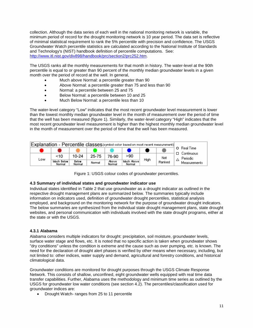
collection. Although the data series of each well in the national monitoring network is variable, the minimum period of record for the drought monitoring network is 10 year period. The data set is reflective of minimal statistical requirement to rank the 5% percentile with precision and confidence. The USGS Groundwater Watch percentile statistics are calculated according to the National Institute of Standards and Technology's (NIST) handbook definition of percentile computations. See: http://www.itl.nist.gov/div898/handbook/prc/section2/prc252.htm. The USGS ranks all the monthly measurements for that month in history. The water-level at the 90th percentile is equal to or greater than 90 percent of the monthly median groundwater levels in a given month over the period of record at the well. In general,
• Much above Normal: a percentile greater than 90 • Above Normal: a percentile greater than 75 and less than 90 • Normal: a percentile between 25 and 75 • Below Normal: a percentile between 10 and 25 • Much Below Normal: a percentile less than 10
The water-level category “Low” indicates that the most recent groundwater level measurement is lower than the lowest monthly median groundwater level in the month of measurement over the period of time that the well has been measured (figure 1). Similarly, the water-level category “High” indicates that the most recent groundwater level measurement is higher than the highest monthly median groundwater level in the month of measurement over the period of time that the well has been measured.
Figure 1: USGS colour codes of groundwater percentiles.
4.3 Summary of individual states and groundwater indicator use Individual states identified in Table 2 that use groundwater as a drought indicator as outlined in the respective drought management plans are summarized below. The summaries typically include information on indicators used, definition of groundwater drought percentiles, statistical analysis employed, and background on the monitoring network for the purpose of groundwater drought indicators. The below summaries are synthesized from the individual state drought management plans, state drought websites, and personal communication with individuals involved with the state drought programs, either at the state or with the USGS.
4.3.1 Alabama Alabama considers multiple indicators for drought: precipitation, soil moisture, groundwater levels, surface water stage and flows, etc. It is noted that no specific action is taken when groundwater shows "dry conditions" unless the condition is extreme and the cause such as over pumping, etc. is known. The need for the declaration of drought alert phases is verified by other means when necessary, including, but not limited to: other indices, water supply and demand, agricultural and forestry conditions, and historical climatological data. Groundwater conditions are monitored for drought purposes through the USGS Climate Response Network. This consists of shallow, unconfined, eight groundwater wells equipped with real time data transfer capabilities. Further, Alabama uses the methodology and minimum time series as outlined by the USGS for groundwater low water conditions (see section 4.2). The percentiles/classification used for groundwater indices are:
• Drought Watch- ranges from 25 to 11 percentile
12
• Drought Warning- ranges from 10 to 6 percentile • Drought Emergency- less than 5 percentile
Website: http://www.adeca.alabama.gov/Divisions/owr/Pages/Drought.aspx
4.3.2 Arizona Although groundwater is listed as an indicator in the 2004 Arizona Drought Preparedness Plan, some of the methodology described has changed. Groundwater is not a part of the numeric equation for determining drought levels in Arizona. Precipitation and surface water data are calculated to derive the index. Presently, groundwater is used only qualitatively in Arizona with perhaps more emphasis in those watersheds where precipitation and stream flow data does not exist. Future research is aimed at using groundwater in a quantitative manner, possibly by a modified Palmer index, although the groundwater level signature may include influences other than a climate response such as pumping, artificial recharge, etc (Ruth Greenhouse, pers. comm., August 2012). Website: http://www.azwater.gov/AzDWR/StatewidePlanning/Drought/documents/operational_drought_plan.pdf
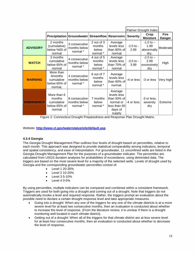
4.3.3 Connecticut The purpose of the Connecticut Drought Preparedness and Response Plan is to preserve essential water uses during a drought by providing a framework for the appropriate assessment of and response to drought conditions. Each drought stage is determined by weighing all of the criteria used to determine the severity of a drought (precipitation, groundwater, streamflow, reservoir levels, palmer drought severity index, crop moisture index and the fire danger). When 4 of the listed 7 drought indicators for a particular region are at the same or more severe level of drought condition for three consecutive months, then that region is flagged as being under a certain drought level. If any of the 4 indices improve to a lesser drought condition in any of the three months, then that region requires another 3 months with 4 of 7 indicators showing more severe drought to increase drought levels. These seven drought criteria mentioned above are re-assessed each month, therefore, the drought stages are adjusted only once per month. This facilitates a smooth progression from Advisory to Watch to Warning on a monthly basis if the drought worsens. The spacing of re-assessments every 30 days also provides time for conservation measures to be effective. Connecticut’s groundwater condition is from the USGS Climate Response Network. The monitoring network consists of 6 real time, unconfined shallow monitoring wells. A minimum of 10 years of monthly data is used to compute monthly statistics. The Connecticut Drought Preparedness and Response Plan outlines 4 levels of drought, including groundwater (figure 2):
• Drought Advisory: Three consecutive months below normal • Drought Watch: Four consecutive months below normal • Drought Warning Stage: Four consecutive months below normal, • Drought Emergency Stage: Eight consecutive months below normal
Normal levels for groundwater are defined as the 25th percentile of the period of record
13
Palmer Drought Index
Precipitation Groundwater Streamflow Reservoirs Severity Crop Moisture
Fire Danger
ADVISORY 2 months
(cumulative) below %65 of
normal
3 consecutive months below
normal *
2 out of 3 months below
normal *
Average levels less
than 80% of normal
-2.0 to -2.99
-1.0 to –1.99
abnormally dry,
Moderate
WATCH 3 months
cumulative below 65% of
normal
4 consecutive months below
normal *
4 out of 5 months below
normal *
Average levels less
than 70% of normal
-3.0 to -3.99
-2.0 to –2.99
excessively dry
High
WARNING
More than 4months
cumulative below 65% of
normal,
4 consecutive months below
normal *
6 out of 7 months below
normal *
Average levels less
than 60% of normal.
-4 or less -3 or less Very high
EMERGENCY
More than 6 months
cumulative below 65% of
normal
8 consecutive months below
normal *
7 months below
normal *
Average levels less
than 50% of normal or
less than 50 days of supply
-4 or less. -3 or less, severely
dry Extreme
Figure 2: Connecticut Drought Preparedness and Response Plan Drought Matrix.
Website: http://www.ct.gov/waterstatus/site/default.asp
4.3.4 Georgia The Georgia Drought Management Plan outlines four levels of drought based on percentiles, relative to each month. This approach was designed to provide statistical comparability among indicators, temporal and spatial consistency, and ease of interpretation. For groundwater, 11 unconfined wells are listed in the Georgia Drought Management Plan for the purposes of a groundwater indicator. The percentiles are calculated from USGS duration analyses for probabilities of exceedance, using detrended data. The triggers are based on the most severe level for a majority of the selected wells. Levels of drought used by Georgia and the corresponding groundwater percentiles consist of:
• Level 1 20-35% • Level 2 10-20% • Level 3 5-10% • Level 4 0-5%
By using percentiles, multiple indicators can be compared and combined within a consistent framework. Triggers are used for both going into a drought and coming out of a drought. Note that triggers do not automatically invoke a level and required response. Rather, the triggers prompt an evaluation about the possible need to declare a certain drought response level and take appropriate measures.
• Going into a drought: When any one of the triggers for any one of the climate districts is at a more severe level for at least two consecutive months, then an evaluation is conducted about whether to increase the level of response. (From the literature review, it is unclear if there is a drought monitoring well located in each climate district).
• Getting out of a drought: When all of the triggers for that climate district are at less severe level for at least four consecutive months, then an evaluation is conducted about whether to decrease the level of response.
14
Website: http://www.georgiaplanning.com/watertoolkit/Documents/WaterConservationDroughtManagement/DroughtMgtPlanFinal03.pdf
4.3.5 Maryland Maryland Department of the Environment uses precipitation, streamflow, groundwater levels, and reservoir storage as drought indicators. Indicators are evaluated by comparing current conditions to historical data for the period of record to determine if there is a water supply deficit. Groundwater drought analysis is completed on 20 unconfined wells used by both USGS and State of Maryland monitoring well networks, distributed in each of the four state climate regions (Wendy McPherson, pers. comm., September 2012). The frequency of data collection is monthly which is manual, continuous, or real time (telemetry) data collection. The minimum time series data for the drought indicator wells is roughly 10-30 years to provide adequate statistical representation of water levels. Groundwater conditions are evaluated on a monthly basis, using the measured value or for continuous data, the last value of the month. The monthly levels are compared with values equivalent to the 25th, 10th, and 5th percentiles of historical records, which corresponds to:
• Normal: >25 percentile • Watch: 11-25 percentile • Warning 6-10 percentile • Emergency: 0-5 percentile
Websites: http://www.mde.maryland.gov/programs/Water/DroughtInformation/DroughtInfoandIndicators/Pages/index.aspx http://www.mde.state.md.us/programs/Water/DroughtInformation/Documents/www.mde.state.md.us/assets/document/drought/droughtreport.pdf
4.3.6 Massachusetts The Massachusetts Drought Management Team uses 7 non-prioritized indicators of drought: drought severity index, crop moisture index, fire danger, precipitation, groundwater levels, streamflow levels, and index reservoir levels. The state is split into six drought evaluation regions. Similar to Connecticut, when 4 of 7 drought indicators for a particular region are at the same or more severe level of drought condition for three consecutive months, then that region is flagged as being under a certain drought level. If any of the 4 indices improve to a lesser drought condition in any of the three months, then that region requires another 3 months with 4 of 7 indicators showing more severe drought to increase drought levels. Status of the groundwater condition is from the USGS Climate Response Network which consists of 88 wells to determine regional groundwater conditions. All wells are unconfined. Twenty of the 88 wells are real time and the remaining 68 are measured monthly. A minimum of 5 years of monthly data are required to compute monthly statistics. The 5-year period for statistical computations is from the start of well record. There is no common period used for all wells (i.e. 20-yr period from 1970-1989); as a result, there could be some bias if the statistics for a new well (e.g. with only 5 years of monthly measurements that were made during a relatively wet or dry period) was compared to the statistics of an older well with 50 years of monthly measurements made during various groundwater level conditions. The oldest monthly wells started in 1936 (Topsfield 1), 1939 (Winchendon 13), and 1940 (Winchester 14; Roy Socolow, pers. comm., September 2012). The newest well added to the network is Westford 160 (2001). The groundwater drought level determination is based on the number of consecutive months groundwater levels are below normal (lowest 25% of period of record). Massachusetts uses the groundwater percentiles as defined and provided monthly by the USGS for the groundwater indicator, which corresponds to:
• Much above normal: a percentile greater than 90
15
• Above Normal: a percentile greater than 75 and less than 90 • Normal: a percentile between 25 and 75 • Below Normal: percentile between 10 and 25 • Much Below Low: a percentile less than 10
Website: http://www.mass.gov/dcr/watersupply/rainfall/drought.htm
4.3.7 New Jersey Administered through the New Jersey Department of Environmental Protection (DEP), New Jersey’s drought indicators are designed to 1) integrate large amounts of data about water resource supply, 2) communicate to the public and decision makers accurate information, 3) be reasonable, 4) be based on real-time data, and 5) be distributed quickly over the internet (Hoffman and Domber, 2003). Groundwater levels are monitored for drought purposes at 19 unconfined groundwater wells across the State. All wells were selected to minimize, as much as possible, impacts on water levels by any nearby pumping (Jeffrey Hoffman, pers. comm., September 2012). It is noted that groundwater levels in confined aquifers in New Jersey do not show a direct impact of drought. The USGS posts water levels from these wells over the Internet. Mean monthly groundwater levels are the basis of the groundwater drought indicator. Observed daily levels are compared to monthly exceedances frequency curves developed from a statistical analysis of mean monthly values against the following percentiles:
• Near or above normal: greater than 50% • Moderately dry: above 30% but less than or equal to 50% • Severely dry: above 10% but less than or equal to 30% • Extremely dry: if the observed groundwater level on a given day is in the lowest 10% of observed
values for that month The 10%, 30% and 50% exceedance frequencies were chosen to be consistent with what was developed for the stream flow drought indicators. The stream flow and groundwater drought indicators depend on a frequency analysis of historical values. The development and application of a groundwater drought indicator is done in three steps:
1) Compute mean monthly water levels for the period of record 2) Set up the frequency distributions for calendar-month water levels. The statistics calculated in this
step are very dependent on the length of the data record. 3) Compare observed water level to the frequency distribution for that month to determine drought
status This process was implemented on a formal basis in January, 2001. It is generally done for each well in the drought network weekly during dry times and biweekly during normal and wet periods. See Hoffman and Domber (2004) for a detailed outline of the New Jersey drought indicator for New Jersey. Website http://www.njdrought.org/
4.3.8 New York New York State produces a drought index as guidance for local public water supplies. It combines the following indicators: precipitation, surface water, groundwater levels, and reservoir levels. The weighting of the several components is different for each of the New York Drought Regions reflecting the different source of water for public water supply systems in each Region with the focus on public water supply. Also, the Palmer Drought Index (PDI) is used in New York, a measure of soil moisture computed by the National Weather Service.

16
Regarding groundwater, New York utilizes the USGS well reports to compute the groundwater portion of the drought index (Brenan Tarrier, pers. comm., November 2012). The wells consist mostly of unconfined wells, with a few that may be partially confined. Several New York monitoring wells were activated very recently with some having between 5-10 years of data. These monitoring wells are included these in the drought index calculation, but precaution is noted whether a local minimum (or maximum) is skewing the regional calculation. It is noted that if these short term wells were not included, then New York state would not have sufficient coverage to generate a meaningful number for some of the regions.
Although the percentiles are not readily defined, New York has a four drought stage: Drought Watch, Drought Warning, Drought Emergency, and Drought Disaster.
Website: http://www.dec.ny.gov/lands/5011.html
4.3.9 Pennsylvania The Pennsylvania Department of Environmental Protection has defined groundwater percentile ranges of 10 to 25, 5 to 10, and 0 to 5 to represent entry into watch, warning and emergency, respectively. The USGS maintains the real-time groundwater monitoring well network including maintenance, data analysis, and on-line data distribution. The wells have a minimum of 10 years of monthly data and consist of both of confined and unconfined aquifers with a well in almost every county. Every day, groundwater levels in USGS observation wells are used to compute an average level of the last 30 days preceding that day (called the “30-day moving average groundwater level”), that serves as a groundwater indicator. The groundwater indicators are then compared with statistical groundwater-level values known as “percentiles” derived from historic observation-well records. It is noted that Chester County, PA has an additional groundwater monitoring network which includes drought monitoring. The network currently consists of 23 wells with water levels measured monthly. The monthly drought-trigger water levels use at least 15 years of monthly water-level measurements in which the hydrologic properties of the well must have remained stable, and the well must not have been affected by outside factors, such as pumping stress (Cinotto, 2007). Websites: http://www.portal.state.pa.us/portal/server.pt/community/drought_information/10606 http://pa.water.usgs.gov/drought/indicators/gw/ http://pa.water.usgs.gov/drought/indicators/gw/explanation.php
4.3.10 Rhode Island Rhode Island drought declaration uses four major indices: the Palmer Drought Index, precipitation, groundwater and stream flow. Precipitation, groundwater and surface water are evaluated in terms of departure from normal. Normal is defined as the statistical average of the data for the period of record. A corresponding drought phase is assigned when three of the four major hydrologic indices reach a designated threshold (Kathleen Crawlet, pers. comm., September 2012). The Plan defines five phases of drought consistent with the Drought Watch/Warning System of the National Weather Service:
1. Normal: 1 month below normal 2. Advisory: at least 2 out of 3 months below normal 3. Watch: 4-5 consecutive months below normal 4. Warning: 6-7 consecutive months below normal; observation wells recording monthly record lows 5. Emergency: >7 months below normal; observation wells recording monthly record lows.
The Rhode Island groundwater monitoring network, as monitored by the USGS, consists of 38 wells completed in stratified drift and till corresponding unconfined aquifer conditions (Gardner Bent, pers. comm., September 2012). The wells have at least 10 years of data. In most of the wells, this corresponds to monthly measurements. Rhode Island uses the percentiles as defined by the USGS for the groundwater indicator to evaluate groundwater conditions on a statewide basis, which corresponds to:

17
• Much above normal: a percentile greater than 90 • Above Normal: a percentile greater than 75 and less than 90 • Normal: a percentile between 25 and 75 • Below Normal: percentile between 10 and 25 • Much Below Low: a percentile less than 10
Therefore, a drought phase determination is based on the number of months groundwater levels are below normal (lowest 25% of period of record). Local water suppliers also monitor public wells in order to make seasonal water availability comparisons. Websites: http://www.wrb.ri.gov/work_programs_drought/Hydrologic_Drought_Indices.pdf
4.3.11 Virginia Virginia uses four indicators for drought: groundwater, streamflow, precipitation, and reservoir levels (figure 3). The states utilizes monitoring wells completed in the shallow water table for drought evaluations and shallow fractured bedrock in some areas west of Route 95 where fractured rock formations are indicative of water table conditions. For groundwater drought monitoring, Virginia utilizes 16 wells in 13 drought evaluation regions (Brian McGurk. Pers. comm.., July 2012). The minimum length of record is 10 years for the wells with levels determined based on the averaged monthly levels. The drought monitoring wells were selected on the basis of period of record and relative location within the drought evaluation region. In drought evaluation regions where no appropriate monitoring wells exist, the groundwater indicator is not be used.
Figure 3: Drought indicators for Virginia, September 25, 2012
(http://www.deq.virginia.gov/Programs/Water/WaterSupplyWaterQuantity/Drought.aspx)
Measured groundwater levels are compared with historic level statistics for the period of record for the following percentiles:
18
• Normal Conditions: Measured groundwater levels above the 25th percentile for all historic levels. • Drought Watch Condition: Measured groundwater levels between the10th and 25th percentiles for
all historic levels • Drought Warning Conditions: Measured groundwater levels between the 5th and 10th percentile
for all historic levels. • Drought Emergency Conditions: Measured groundwater levels below the 5th percentile for all
historic levels (figure 3). It is noted that the USGS uses single percentile classes for data values less than the 10th percentile and greater than the 90th percentile. These additional divisions are necessary for consistency with the surface-water flow-duration web pages. Website: http://www.deq.virginia.gov/Programs/Water/WaterSupplyWaterQuantity/Drought/DroughtIndicators.aspx 5.0 Summary and Recommendations This groundwater indicator literature review concentrated on jurisdictions in the USA and Canada at the state/provincial level. It was found that groundwater drought indicators are limitedly utilized in the USA and Canada: notably in Alabama, Connecticut, Georgia, Maryland, Massachusetts, New Jersey, New York, Pennsylvania, Rhode Island, Virginia and Manitoba; respectively. These jurisdictions employ a widespread application of the percentile method for a groundwater indicator insomuch as no other applied groundwater indicator methodology was found to be used. The percentile thresholds vary across the different jurisdictions. In general, the 25th percentile plus is considered normal groundwater levels, the 10th -25th range is considered dry (or drought watch), and below the 10th or 5th percentile is considered a drought emergency. Key parameters are summarized in Table 2 for the jurisdictions that use groundwater as a drought indicator. Broadly summarized for the individual States, the drought monitoring wells are generally completed into unconfined/water table environments. These drought monitoring wells are managed by the USGS and maybe complimented by local or state monitoring initiatives. The minimum period of record used by the USGS is 10 years with 80% completion for a groundwater drought indicator to capture the recent climatic extremes, although Massachusetts and New York uses a minimum of 5 years to compute the monthly statistics. Further some individual states, such as but not limited to Maryland and Rhode Island, use a combination of continuously logged wells and manual monthly statics to determine the percentiles for groundwater levels. The spatial distribution of the drought monitoring wells vary per individual jurisdiction: some states have a drought monitoring well in roughly every county (e.g. Pennsylvania) whereas other states have monitoring wells in climate regions which are composite watersheds/counties (e.g. Georgia and Maryland). For jurisdictions that apply the percentile method with monthly data, it is unclear if this is monthly data or a 30 day running average (e.g. like Pennsylvania). For the jurisdictions that use groundwater as a trigger for drought, the literature reviewed provided no indication of how often or how effectively the groundwater indicator has been applied or if any jurisdictions used groundwater to trigger drought or maintain a drought level. Table 2: Summary of Key Groundwater Monitoring Parameters per Jurisdiction for Drought Indicators.
Jurisdiction Minimum Length of time series (years)
Number of wells Monitoring in confined vs unconfined aquifers
Data collection method: continuous, manual, or combination
Manitoba 37 5 Unconfined and confined Alabama 10 8 unconfined Continuous Maryland 10 20 Unconfined Continuous and
manual statics Georgia 10 11 Unconfined
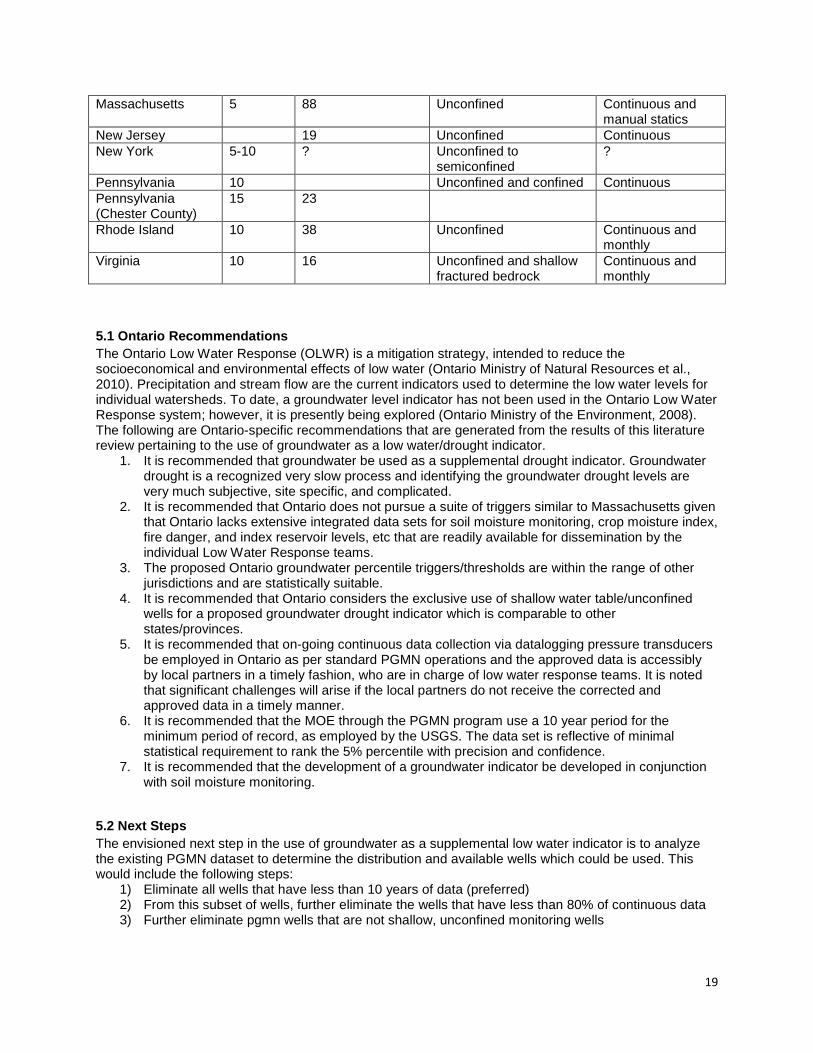
19
Massachusetts 5 88 Unconfined Continuous and manual statics
New Jersey 19 Unconfined Continuous New York 5-10 ? Unconfined to
semiconfined ?
Pennsylvania 10 Unconfined and confined Continuous Pennsylvania (Chester County)
15 23
Rhode Island 10 38 Unconfined Continuous and monthly
Virginia 10 16 Unconfined and shallow fractured bedrock
Continuous and monthly
5.1 Ontario Recommendations The Ontario Low Water Response (OLWR) is a mitigation strategy, intended to reduce the socioeconomical and environmental effects of low water (Ontario Ministry of Natural Resources et al., 2010). Precipitation and stream flow are the current indicators used to determine the low water levels for individual watersheds. To date, a groundwater level indicator has not been used in the Ontario Low Water Response system; however, it is presently being explored (Ontario Ministry of the Environment, 2008). The following are Ontario-specific recommendations that are generated from the results of this literature review pertaining to the use of groundwater as a low water/drought indicator.
1. It is recommended that groundwater be used as a supplemental drought indicator. Groundwater drought is a recognized very slow process and identifying the groundwater drought levels are very much subjective, site specific, and complicated.
2. It is recommended that Ontario does not pursue a suite of triggers similar to Massachusetts given that Ontario lacks extensive integrated data sets for soil moisture monitoring, crop moisture index, fire danger, and index reservoir levels, etc that are readily available for dissemination by the individual Low Water Response teams.
3. The proposed Ontario groundwater percentile triggers/thresholds are within the range of other jurisdictions and are statistically suitable.
4. It is recommended that Ontario considers the exclusive use of shallow water table/unconfined wells for a proposed groundwater drought indicator which is comparable to other states/provinces.
5. It is recommended that on-going continuous data collection via datalogging pressure transducers be employed in Ontario as per standard PGMN operations and the approved data is accessibly by local partners in a timely fashion, who are in charge of low water response teams. It is noted that significant challenges will arise if the local partners do not receive the corrected and approved data in a timely manner.
6. It is recommended that the MOE through the PGMN program use a 10 year period for the minimum period of record, as employed by the USGS. The data set is reflective of minimal statistical requirement to rank the 5% percentile with precision and confidence.
7. It is recommended that the development of a groundwater indicator be developed in conjunction with soil moisture monitoring.
5.2 Next Steps The envisioned next step in the use of groundwater as a supplemental low water indicator is to analyze the existing PGMN dataset to determine the distribution and available wells which could be used. This would include the following steps:
1) Eliminate all wells that have less than 10 years of data (preferred) 2) From this subset of wells, further eliminate the wells that have less than 80% of continuous data 3) Further eliminate pgmn wells that are not shallow, unconfined monitoring wells
20
4) Lastly, assess the remaining subset of wells in the response to climate prior, anthropogenic impacts, as outlined in the well selection methodology developed by UTRCA.
This will provide a subset of wells and the associated geographic distribution that would be suitable to be used as a groundwater indicator. Concurrently with the delineation of suitable wells to be used as a groundwater indicator, a process is required to be developed between the PGMN program lead and partners to ensure timely accessibility to approved corrected data. Lastly, further exploration is required on how groundwater percentiles, either as a recommended supplemental or primary indicator, will factor in with the existing Ontario Low Water indicator system and be effectively communicated.
21
6.0 References
Cinotto, P.L. 2007. Drought-trigger groundwater levels in Chester County, Pennsylvania, for the period of record ending May 2006: U.S. Geological Survey Data Series 292: 9p. Hoffman, J.L and Domber, S.E. 2004. Development of Streamflow and groundwater drought indicators for New Jersey. New Jersey Geological Survey Open File Report OFR 04-2: 27p. Hoffman, J., and Domber, S. 2003. New Jersey Water-Supply Drought Indicators. New Jersey Geological Survey Information Circular. State of New Jersey: 2p. Jacques Whitford. 2007. Progress Draft Report- Develop a Groundwater Indicator for Ontario Low Water Response; Phase I: Determination of a Indicator Methodology: 43p. Mendicino, G., Senatore, A., & Versace, P. 2008. A Groundwater Resource Index for drought monitoring and forecasting in a Mediterranean climate. Journal of Hydrology, 357: 282–302. Ontario Ministry of the Environment. 2008. Draft: Provincial Groundwater Monitoring Network Guidance Document for using the Percentile Method for Calculating Trigger Levels for the Ontario Low Water Response Plan. Environmental Monitoring and Reporting Branch: 15p. Ontario Ministry of Natural Resources, Ontario Ministry of the Environment, Ontario Ministry of Agriculture, Food and Rural Affairs, Ontario Ministry of Municipal Affairs and Housing, Ontario Ministry of Research and Innovation, Association of Municipalities of Ontario, and Conservation Ontario. 2010. Ontario Low Water Response: 48p. http://www.mnr.gov.on.ca/stdprodconsume/groups/lr/@mnr/@water/documents/document/mnr_e002322.pdf Steinemann, A.C., and Cavalcanti, L.F.N. 2006. Developing Multiple Indicators and Triggers for Drought Plans. Journal of Water Resources Planning and Management, 132: 164-174. Upper Thames River Conservation Authority. 2008. Groundwater Indicator Pilot Study- Draft prepared for: Ontario Ministry of Natural Resources Water Resources Section: 66p. Wanders, N., van Lanen, H.A.J., and van Loon, A.F. 2010. Indicators for Drought characterization on a Global Scale. WATCH- Water and Global Change Technical Report 24: 93p. http://www.eu-watch.org/media/default.aspx/emma/org/10646416/WATCH+Technical+Report+Number+24+Indicators+For+Drought+Characterization+on+a+Global+Scale.pdf.