Research Computing Clusters: Kure and Killdevil Research ...
LLiiffee aanndd DDeeaatthhooff HHaawwaaiiiiaann
VVoollccaannooeessKauai (4-5 Ma)
Mauna Loa, Hawaii (<1 Ma)
Kilauea, Hawaii (<0.6 Ma)
GardnerPinnacles (12 Ma)
Kure Atoll (30 Ma)
Hawaiian Ridge
Pacific Plate
Hawaiian hotspot
Emperor
Seamounts

Gardner
0
-2000
-400070075080085090095010001050110011501200125013001350140014501500155016001650
NW SEPinnaclesRaita St. Rogatien Brooks French FrigateShoals Nihoa
MiddleTwinBanksKeoea BankMokumanamanaBank
Ele
vatio
n(m
)
P a c i f i c O c e a n
Areaof
map
EmperorSeamounts
Main Hawaiian Islands
Northwest Hawaiian Islands
Nihoa
GardnerLaysan
MidwayPearl &
Hermes Reef
Raita
Northampton
Middle
PioneerBank
St. Rogatien
BrooksBank French
TwinBanks
Kure
Keoea
LisianskiMaroReef
FrigateShoals
Bank
Mokumanamana
Pinnacles
Necker Ridge
Horizon Guyot
Mid-PacificMountains
500 km
HawaiianRidge
Ni’ihau
Kaua’i
O’ahu
Moloka’i
Lana’i
Kaho’olawe
Maui
Hawai’i
050100150200250300350400450500550600
0
-2000
2000
4000
-4000
SENWKaua‘i Wai‘anae Ko‘olau
WestMoloka‘i
WestMaui
Haleakala
Kohala
Mauna Kea
KilaueaEast
Moloka‘i
170017501800185019001950200020502100215022002250230023502400245025002550260026502700
MaroLaysanMidway
Pearl & NorthamptonPioneerBankKure Lisianski
0
-2000
-4000
Ele
vatio
n(m
)E
leva
tion
(m) NW SEWest East
SalmonBank
SalmonBank Hermes Reef
Mauna Loa
Lana‘iKaho‘olawe
Lo‘ihi
Hualalai
Mahukona
Distance from Kilauea (km)
Ni‘ihau
(0-1 Ma)
(4-6 Ma)
(10 Ma)
(12 Ma)
(12 Ma)(20 Ma)
(28 Ma)
Pacific plate9-10 cm/yr
Pacific plate9-10 cm/yrN
hotspotHawaiian

The Hawaiian Ridge
1
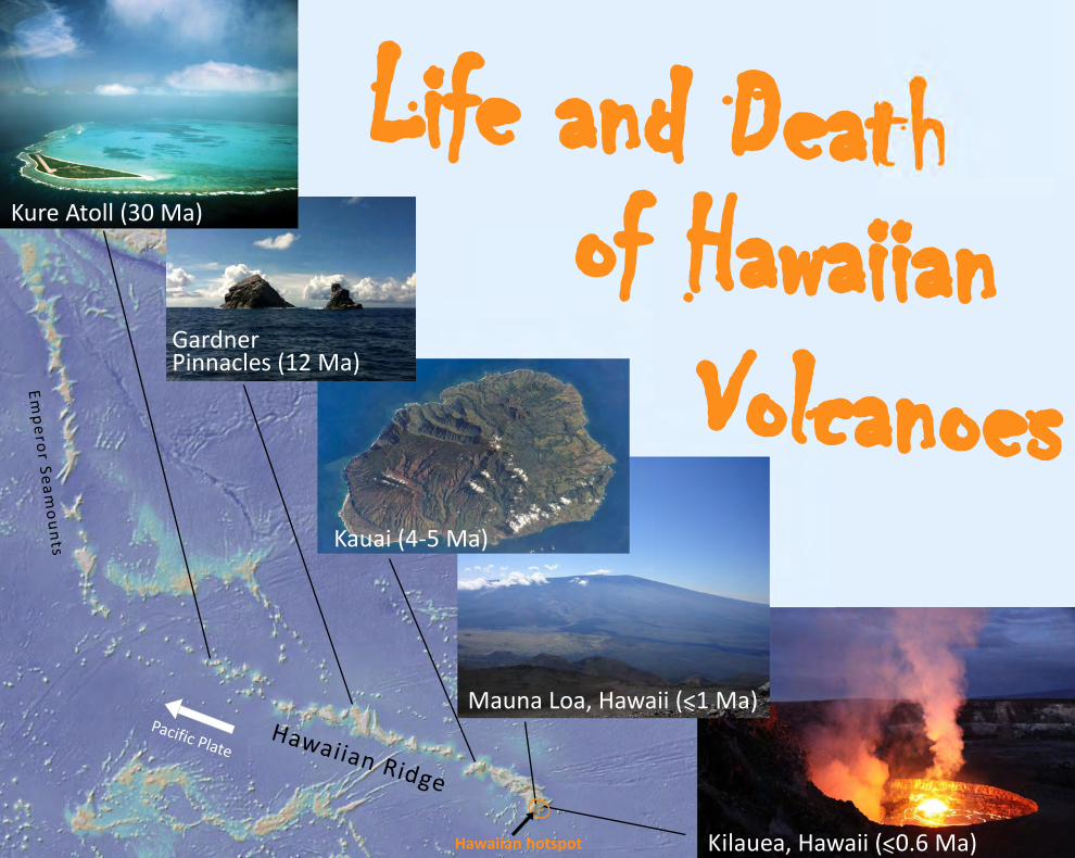
The Hawaiian‐Emperor Chain (Fig. 1 inset) is the classic example of a hotspot chain formed by a mantle plume. It is one of the tectonically simplest (distant from any plate margin or continent for over 70 Myr) and longest examples of an oceanic island chain or hotspot track on Earth, with >100 volcanoes formed over 82 million years and extending ~6000 km in length. The active southeast portion of the chain (the Main Hawaiian Islands) is surrounded by a ~1000 km‐wide bathymetric swell, which is thought to be associated with a hot buoyant mantle plume beneath the lithosphere (Fig. 1).
The Hawaiian‐Emperor Chain can be subdivided into the Emperor Seamounts north of the Hawaiian‐Emperor Bend (~2500 km long segment with at least 45 volcanoes), and the Hawaiian Ridge south of the Hawaiian‐Emperor Bend to the Island of Hawai’i (~3500 km long with 70 volcanoes) where the Hawaiian hotspot is currently forming the largest and most productive volcanoes on Earth (Fig. 1 inset). The Hawaiian Ridge extends from the northwest atolls of Kure and Midway to currently active Kīlauea Volcano on the Island of Hawai‘i to the southeast (Fig. 1). The Hawaiian Ridge can also be subdivided into the Northwest Hawaiian Islands (Kure Atoll to Middle Bank Seamount, ~2800 km long segment with at least 51 volcanoes) and the Main Hawaiian Islands (Ni’ihau to the Island of Hawai’i, ~700 km long with 19 volcanoes).
The Hawaiian Ridge is made up of volcanic island mountains with some of their bases as deep as 5500 m below sea‐level and in the Main Hawaiian Islands some of their summits rise as high as 4200 m above sea‐level. The seventy volcanoes of the Hawaiian Ridge range in age from ~30 Myr old in the northwest (Kure Atoll) to ~12 Myr old in the middle of the ridge (Gardner Pinnacles), to less than 1 Myr old at the southeast end of the ridge above the Hawaiian hotspot (Fig. 1). Hawaiian volcanoes grow from the seafloor to their full height above sea‐level in about 1 to 1.5 Myr. After their formation each volcanic island moves off the hotspot with the Pacific plate, currently moving about 9‐10 cm/yr to the northwest.
Figure 1. Map of the Hawaiian Ridge subdivided into the Northwest Hawaiian Islands and the Main Hawaiian Islands. The Hawaiian hotspot is located at the southeast end of the ridge (orange circle) beneath the Island of Hawaii. The ages for the volcanoes, some shown on the map, increase from east to west along the ridge. The inset shows the Hawaiian‐Emperor Chain in the middle of the Pacific Ocean. Along the bottom are three profiles (with vertical exaggeration) of the Hawaiian Ridge, the top one starting at the northwest end of the ridge, and the bottom one ending at the southeast end of the ridge. Green areas are land above sea‐level.
Almost all of the land above sea‐level on the Hawaiian Ridge is in the Main Hawaiian Islands (> 99%; Fig. 1 profiles on bottom). There is very little land area above sea‐level in the Northwest Hawaiian Islands. Midway Atoll in the Northwest Hawaiian Islands is the only island northwest of Kaua’i and Ni’ihau inhabited by humans year round. The Northwest Hawaiian Islands are mainly inhabited by seabirds, green turtles and monk seals.
Most of the volcanic edifices of the Northwest Hawaiian Islands, northwest of Mokumanamana are capped by coral reefs. The best studied example is Midway Volcano, at the northern end of the Ridge where drilling showed it is capped by ~400 m of coralline debris with some interbedded clay. Coral reefs begin forming on the flanks of the volcanoes near sea level after most of the volcanic activity crossing the coast subsides. The coral reefs continue to grow around the islands as the volcano drifts off the hotspot to the northwest, and grow upwards near sea‐level as Hawaiian volcanoes are submerged as they subside during and after their formation.
The volcanoes of the Northwest Hawaiian Islands are generally much less voluminous than those in the Main Hawaiian Islands (except around Gardner Pinnacles). Many of these volcanoes formed as isolated features on the deep ocean floor (e.g., Kure and Midway in the NW; Fig. 1) rather than directly adjacent to another volcano. However, some volcanoes formed on the flanks of adjacent volcanoes similar to the Main Hawaiian Islands (e.g., Mokumanamana; Fig. 1). Beginning in 2006, the Northwest Hawaiian Islands became protected as the Papahānaumokuākea Marine National Monument, one of the largest marine protected areas in the world.

0
5
15
10Dep
th(k
m)
2001000100200300400500 300 400 500Distance from axis (km)
NESW
Maui Nui
Oceanic crust
050100150200250300350400450500550600Distance from Kilauea (km)
0
5
SENWKaua‘i Wai‘anae Ko‘olau
WestMoloka‘i
WestMaui
Haleakala
Kohala
Mauna Kea
KilaueaEast
Moloka‘i
Dep
th(k
m)
Mauna Loa
Lana‘iKaho‘olawe
Lo‘ihi
Hualalai
Mahukona
Ni‘ihau
Thickened crust
Oceanic crust15
10
SubsidenceSubsidence Uplift
Flexure of oceanic crust
11 km
12 km
13 km
14 km
NE
SW
SE
NW
Lithospheric mantle
Ni’ihau
Kaua’i
O’ahu
Moloka’i
Lana’i
Kaho’olawe
Maui
Hawai’i
Main Hawaiian Islands
(5-6 Ma)
(4-5.8 Ma)
(2-4 Ma)
(1.5-2.1 Ma)
(1-2 Ma)
(0-1.1 Ma)(1.2 Ma)
(1.3 Ma)
H A W A I I A NM O A T
H A W A I I A NA R C H
HAWAI IAN MOAT
HAWAI IAN ARCH
HAWAI IAN ARCH
H A W A I I A NA R C H
Depth to base of theoceanic crust
line of cross-section
lineof cross-section
(90-100 Myr old)
(90-100 Myr old)Flexural upliftFlexural uplift
Mantle
hotspotHawaiian
KilaueaVolcano
100 km
N
Mantle
A
B
C
D
Ocean

The eight Main Hawaiian Islands extend from southeast to northwest, 625 km from the Island of Hawaii (the Big Island) to Ni’ihau. The Big Island has the largest land area above sea‐level, greater than all of the other Main Hawaiian Islands combined, and has the highest elevations (~13,800 ft or 4200 m above sea‐level). The Main Hawaiian Islands consist of 19 individual shield volcanoes, with 2 shield volcanoes making up the Islands of Oahu, Molokai and Maui and 5 subaerial shield volcanoes on the Big Island (Fig. 2B). Of the entire volume of the Main Hawaiian Islands, from their base on the sea floor to their tops, 97% of the volume is below sea‐level and less than 3% is above sea‐level. The ages of the Main Hawaiian Islands are oldest in the northwest (4‐6 Myr old) and youngest in the southeast (less than ~1 Myr old), because after they grow above the Hawaiian hotspot. Then they move to the northwest on top of the oceanic crust at a rate of about 10 cm/yr. The Hawaiian Islands formed on ~90‐100 Myr old oceanic crust. The Main Hawaiian Islands lie in the middle of a broad swell that is ~1‐1.5 km higher than the surrounding seafloor and ~1000 km across and extends along the axis of the Main Hawaiian Islands. There is a moat (called the Hawaiian Moat), or broad depression, and a flexural arch (called the Hawaiian Arch) surrounding the Main Hawaiian Islands (Fig. 2B). The broad swell creating the Hawaiian Arch is caused by thermal uplift of hotter‐than‐normal, buoyant mantle beneath the Pacific Plate (the Hawaiian mantle plume) that spreads out laterally around the hotspot and is deflected to the northwest by the migrating Pacific Plate.
The Main Hawaiian Islands
2
Figure 2. A) Map of the Hawaiian Islands with white contours indicating the depth to the top of the mantle beneath Hawaii. Lines are shown for profiles. B) Bathymetry of the Main Hawaiian Islands with ages and the Hawaiian Arch and Moat. Gray areas are above sea‐level. C) Profile perpendicular to the Hawaiian Ridge across the area of Maui Nui (Maui, Molokai, Lanai and Kahoolawe). D) Profile along the axis of the Hawaiian Ridge, showing areas of subsidence and uplift. Green areas are above sea‐level. Source for depths in panel A) is Watts and ten Brink (1989).
The Hawaiian Moat around the Hawaiian Islands is from flexural depression of the oceanic crust because of the heavy load of the Hawaiian Islands as they form above the Hawaiian hotspot. The growing load of the Hawaiian Islands flexes the oceanic crust downward as they form on the hotspot and cause the oceanic crust to be flexed upward at a radial distance of ~300 km away from the hotspot (Fig. 2D). Hawaiian volcanoes subside (sink) during and after their formation. It is initially rapid (2.6 mm/yr for the Big Island) and thought to be caused by loading of the lithosphere from the accumulation of lavas above the Hawaiian hotspot. The total amount of subsidence varies (it is inferred from a sharp slope change that marks the former shoreline that represents the maximum extent of the volcano as an island) with the age and size of the volcano.
As the Main Hawaiian Islands move northwest on the oceanic crust, they undergo a period of uplift (currently the islands of Oahu, Molokai and Lanai) as the Hawaiian Islands move over the flexural arch. After they pass the area of flexural uplift they subside once again, for the rest of their lifetime (Fig. 2D). This later subsidence is slower and considered to be a consequence of the lithosphere beneath Hawai‘i becoming colder and more dense.

0
100200300400500600 0
SENW
Dep
th(k
m)
120
90
60
30
0
30
60
90
120
0
Dist
ance
(km
)
Kilauea
Loihi
Kaua‘i Wai‘anae Ko‘olauWest
Moloka‘iWestMaui
HaleakalaKohala
Mauna Kea
KilaueaEast
Moloka‘iMauna Loa
Lana‘iKaho‘olawe
Lo‘ihi
Hualalai
Ni‘ihau
Distance from Kilauea (km)
(~10 cm/yr)

The Hawaiian Mantle Plume
3
(The Hawaiian Hotspot)
Hawaiian volcanism is thought to be the surface manifestation of melting occurring within a deep‐seated mantle plume, or ‘hotspot’, beneath the Pacific Plate (Fig. 3). The hotspot theory was developed in part to explain Hawaiian volcanism. The origin of the hotspot is generally believed to be a plume of high‐temperature material upwelling from the deep mantle (>2500 km deep).
The Hawaiian plume is thought to be a narrow column (~50 km wide) of thermally buoyant, hotter‐than‐normal rock (~250 °C hotter than surrounding mantle). The discovery of a seismically‐defined deep conduit under the Big Island has established support for the presence of a deep mantle plume. Also, erupted lavas with distinctive geochemical compositions indicate they likely originated from a source deep in the mantle. Recent studies indicate that the long‐lived Hawaiian hotspot (>80 Myr) may ultimately originate near the boundary between Earth’s outer liquid core and the lowest part of the mantle (~2900 km deep).
Kīlauea, Mauna Loa and Lō‘ihi are the most active Hawaiian volcanoes that are directly above the central part of the rising mantle plume stem of the Hawaiian hotspot (Fig. 3). The lavas that erupt on these Hawaiian volcanoes are thought to originate from partial melting within the upper Hawaiian plume probably at >100 km depth. These partial melts are extracted from the upwelling mantle within the melting region and pool together and are transported through chemically‐isolated channels towards the surface. The magma system for the Hawaiian volcanoes extend from the melting region to the uppermost parts of the volcanoes.
Figure 3. Hypothetical cross‐section of the Hawaiian mantle plume and Main Hawaiian Islands, with depth (in km) and distance along the axis of the Hawaiian Islands. Colors indicate potential temperature of the mantle in the Hawaiian plume from a model by Ribe and Christensen (1999). The inset shows melt flux, or rate of melt generation, from a model by Farnetani and Hofmann (2010).
Models of mantle plumes indicate the plume likely has a radial structure with a hot central core and temperatures decreasing outward from the plume center. As plume material moves into the temperature range where melting takes place (allowing for decompression melting), the greatest amount of magma (or melt flux) is produced at the center of the plume because of the hotter temperatures (Fig. 3 inset).
Like a flame blowing in the wind, the vigorous Hawaiian mantle plume is strongly elongated in the direction of the plate motion to the northwest, extending far ‘downstream’ from the plume stem along the Hawaiian Ridge. The narrow stem of the Hawaiian plume also spreads out beneath the moving oceanic lithosphere (Pacific plate).
As a shield volcano moves on the oceanic crust above the melting zone at the top of the plume stem, the eruption rate (or melt flux) begins with a low rate and gradually becomes higher and peaks before trailing off (Fig. 3 inset). The youngest volcano on the Hawaiian Ridge, Loihi, rising from the seafloor southeast of the Big Island, does not sample the plume center yet, but is sampling the front edge or ‘upstream’ side of the plume. Conversely, later‐stage volcanism is associated with melts formed from the ‘downstream’ part of the plume.

Growth of the Big Island
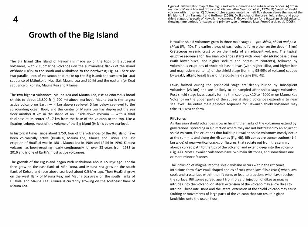
4
The Big Island (the Island of Hawai‘i) is made up of the tops of 5 subaerial volcanoes, with 2 submarine volcanoes on the surrounding flanks of the island offshore (Lō‘ihi to the south and Māhukona to the northwest; Fig. 4). There are two parallel lines of volcanoes that make up the Big Island: the western (or Loa) sequence of Māhukona, Hualālai, Mauna Loa and Lō‘ihi and the eastern (or Kea) sequence of Kohala, Mauna Kea and Kīlauea. The two highest volcanoes, Mauna Kea and Mauna Loa, rise as enormous broad shields to about 13,800 ft (4,200 m) above sea‐level. Mauna Loa is the largest active volcano on Earth — 4 km above sea‐level, 5 km below sea‐level to the surrounding ocean floor, and the center of Mauna Loa has depressed the sea floor another 8 km in the shape of an upside‐down volcano — with a total thickness at its center of 17 km from the base of the volcano to the top. Like a floating iceberg, most of the volume of the Big Island (94%) is below sea‐level. In historical times, since about 1750, four of the volcanoes of the Big Island have been volcanically active (Hualālai, Mauna Loa, Kīlauea and Lō‘ihi). The last eruption of Hualālai was in 1801, Mauna Loa in 1984 and Lō‘ihi in 1996. Kilauea volcano has been erupting nearly continuously for over 33 years from 1983 to 2016 and is one of Earth’s most active volcanoes. The growth of the Big Island began with Māhukona about 1.5 Myr ago. Kohala then grew on the east flank of Māhukona, and Mauna Kea grew on the south flank of Kohala and rose above sea‐level about 0.5 Myr ago. Then Hualālai grew on the west flank of Mauna Kea, and Mauna Loa grew on the south flanks of Hualālai and Mauna Kea. Kīlauea is currently growing on the southeast flank of Mauna Loa.
Hawaiian shield volcanoes grow in three main stages — pre‐shield, shield and post‐shield (Fig. 4D). The earliest lavas of each volcano form either on the deep (~5 km) Cretaceous oceanic crust or on the flanks of an adjacent volcano. The typical eruptive sequence for Hawaiian volcanoes starts with pre‐shield alkalic basalt lavas (with lower silica, and higher sodium and potassium contents), followed by voluminous eruptions of tholeiitic basalt lavas (with higher silica, and higher iron and magnesium contents) of the shield stage (forming 95‐99% of volcano) capped by weakly alkalic basalt lavas of the post‐shield stage (Fig. 4E). Lavas formed during the pre‐shield stage are deeply buried by subsequent volcanism (>3 km) and are unlikely to be sampled after shield‐stage volcanism. Post‐shield stage lavas usually form a thin cap (e.g., <10 to ~1000 m on Mauna Kea Volcano) on the upper parts of the subaerial shield volcanoes extending to near sea level. The entire main eruptive sequence for Hawaiian shield volcanoes may take ~1.5 Myr to form. Rift Zones As Hawaiian shield volcanoes grow in height, the flanks of the volcanoes extend by gravitational spreading in a direction where they are not buttressed by an adjacent shield volcano. The eruptions that build up Hawaiian shield volcanoes mostly occur at the summits and along the rift zones (Fig. 4B). Rift zones are concentrations (1‐4 km wide) of near‐vertical cracks, or fissures, that radiate out from the summit along a curved path to the tips of the volcano, and extend deep into the volcano (Fig. 4A). Most Hawaiian volcanoes have two main rift zones, and sometimes one or more minor rift zones.
The intrusion of magma into the shield volcano occurs within the rift zones. Intrusions form dikes (wall‐shaped bodies of rock when lava fills a crack) when lava cools and crystallizes within the rift zone, or lead to eruptions when lava reaches the surface. Rift zones spread apart from forceful injection of dikes as magma intrudes into the volcano, or lateral extension of the volcano may allow dikes to intrude. These intrusions and the lateral extension of the shield volcano may cause faulting or movements of large parts of the volcano that can result in giant landslides onto the ocean floor.
Figure 4. Bathymetric map of the Big Island with submarine and subaerial volcanoes. A) Cross‐section of Mauna Loa and rift zone of Kilauea (after Swanson et al., 1976). B) Sketch of shield volcano with rift zones. C) Colored circles approximate the melt flux shown above the map of the Big Island. From Farnetani and Hoffman (2010). D) Sketches of the pre‐shield, shield, and post‐shield stages of growth of Hawaiian volcanoes. E) Growth history for a Hawaiian shield volcano, showing time periods for stages and primary type of erupted lava. From Garcia et al. (2005).

050100150200250300350400450500550600
Distance from Kilauea (km)
0
5
SENWKaua‘i Wai‘anae Ko‘olau
WestMoloka‘i
WestMaui
Haleakala
Kohala
Mauna Kea
KilaueaEast
Moloka‘i
Dep
th(k
m)
Mauna Loa
Lana‘iKaho‘olawe
Lo‘ihi
Hualalai
Mahukona
Ni‘ihau
Thickened crust
Oceanic crust15
10
0 1 0 k m
N
H w y 1 1
Hw
y1
30
Hw
y1 3 0
Hw
y 1 3 7
Pu‘u ‘O‘o
Chainof Craters Road
Kupaianaha
MaunaLoa
Halema‘uma‘u
Pacific Ocean
East Rift Zone
Sout
hwes
t Rift
Zone
crater
10 m
plume from summit
Pu‘u ‘O‘o Crater with lava pond, March 2014
35 m
Halema‘uma‘u Crater with new lava lake, Feb. 2014
Mauna LoaMauna Kea
1983-2013Flow field
Lithospheric mantle
vent
Pahoa
A
B
C
D

Kīlauea Volcano is the youngest subaerial volcano in the Hawaiian Islands. Kīlauea Volcano is actively growing through its midlife (≤0.6 Ma). Over the last three and a half decades Kīlauea has been erupting lava at the highest rate of any volcano on Earth. Lavas have destroyed 182 homes and a National Park visitor center, and polluted the air for many Hawai`i residents for decades. The subaerial surface of Kīlauea is almost completely resurfaced with new lava flows about every 1000 years, as it grows on the shoulder of its larger neighbor, Mauna Loa. Gravitational spreading of south flank of Kīlauea Volcano is occurring along a detachment fault system that is rooted near the base of the volcano, making the south part of the volcano susceptible to landsliding. Kīlauea eruptions occur in and around its summit caldera and on the East and Southwest Rift zones (Fig. 5). The East Rift Zone extends about 55 km subaerially and 60+ km underwater (Puna Ridge) and has been much more active than the Southwest Rift Zone in the last few hundred years. Prior to 1955, historical (post‐1820) eruptions on Kīlauea occurred mostly at or near the summit. Since 1955, eruptions on the rift zone have become more common, especially along the East Rift Zone. Kīlauea currently has two active eruptions: Pu‘u ‘Ō‘ō (1983‐present) on the East Rift Zone and a crater in the summit caldera, called Halema‘uma‘u (2008‐present). There are no historical examples of any Hawaiian volcano erupting from two sites for multiple years. Pu‘u ‘Ō‘ō has been Kīlauea’s longest‐lived and largest‐volume historical eruption. The shield‐stage eruptions of Kilauea Volcano shift back and forth between explosive and effusive (lava flow) eruptions over periods of hundreds of years — explosive for over ~1000 years, effusive for ~500 years, explosive for ~300 years and effusive for the last 230 years. Explosive activity (~60% of the time) appears to occur during times of very low magma supply rate to the shallow magma reservoirs in Kīlauea, and may happen at times when the summit caldera intersected the water table.
Recent Volcanism on Kīlauea Volcano
5
Figure 5. Hypothetical cross‐section of the magma plumbing system through the summit and rift zones of Kīlauea. The magma pathways and storage areas are exaggerated in size. Abbreviations are: H, Halema‘uma‘u reservoir; K, Keanakāko‘i reservoir; SC, south caldera reservoir; SWRZ, Southwest Rift Zone. Inset is a plan view of the magma pathways around Kīlauea summit. Figure from Poland et al. (2015). A) Map of flow field from Pu‘u ‘Ō‘ō eruption. B) Photograph of Pu‘u ‘Ō‘ō eruption in March, 2014. C) Photograph of Halema‘uma‘u crater in February, 2014. D) Cross‐section of the Main Hawaiian Islands with location of Kīlauea cross‐section. Photos from USGS Hawaiian Volcano Observatory.
Magma Supply, Storage and Transport Kīlauea Volcano has a complex internal plumbing system that brings magma to the summit and out to the flanks of the volcano through the rift zones (Fig. 5). Recent studies suggest most magma entering Kīlauea may be stored in reservoirs that are 1 to 5 km beneath the summit, where it passes through the summit reservoir system to erupt within the caldera or be transported laterally into the rift zones that may feed eruptions >100 kilometers from the summit. The summit of Kīlauea has a small oval‐shaped caldera (~5 x 3 km), or shallow collapse basin, created by faulting of the upper volcano surface after emptying of magma reservoirs after major eruptions, most recently around about 1500 and 1790 AD. Studies of deformation, gravity and seismicity around the summit suggest there may be two distinct long‐lived connected magma reservoirs, a deeper one at ~3‐5 km depth and a shallower, smaller one at ~1‐2 km depth (Fig. 5). Similar to other basaltic shield volcanoes around the world, magma is transported from the magma reservoirs to where it is erupted or intruded by the emplacement of dikes within the rift zones. Swarms of earthquakes, and the inflation and deflation of the upper volcano surface, are used to track the movements of magma and formation of dikes at different levels within Kīlauea Volcano to help predict and understand these volcanic eruptions.

drowned, inactivereef complex
HEmperor Seamounts
Guyot (Seamount) Stage
Degradation of Hawaiian Volcanoes
subsided coral/algalreef and beach complexes
wave erodedsea cliff
E
reef / beach terraces from sea level
variation
F
complex of reef and beach terraces
lagoonal depositionof fine lime sediment
old eroded surfaceof volcanic island
G
Rejuvenated Stage
Atoll Stage
SubmarinePre-shield Stage
Declining Post-Shield
Stage
A
B
D
weathering and erosion;extensive on windward side
development ofcoral / algal fringing
reefs
mixed mantle andbasal volcano -
upper crust magma
C
rift zone eruptions
near summitreservoir
dikesincipient coral / algal reef growth
Growth of Hawaiian Volcanoes
Shield-building
Emergent
Stage
Subaerial, Shield-building
Stage
Late Erosional to Early Atoll Stages
stacked summitcraters
fissure (dike) fed rift zone eruptions
pillow lavas
deep mantle sourceof alkalic magma
landslidedebris
cycles of summit cratergrowth and collapse
landslides deposits
explosive, glassysediment
pillow lavas
continued basalspreading along
thrust faultsdeep mantle sourceof tholeiitic magma
continued subsidence owing toincreasing weight of volcanic mass
repeated growth and collapseof summit crater
continued subsidence of oceanic crust
pahoehoe and aa lavasmostly from summit and
rift zone eruptions
scattered cinder cones
continued, but declining rate ofsubsidence
thick alkalic cap (flows and cones)
eroded mountainalkalic volcanism
(explosive cinder conesand lava flows)
reef terracesdeveloped during
sea-levelvariations
uplift as volcanic massmoves across flexural arch
Increasing water depth
erosionat decreasing rate small sand / gravel
reef rubble islands
declining subsidence
continued development of algal-dominated reef complex Increasing
water depth
minor subsidence ofvolcanic mass
blanket of marinemud across
seamount complex
Increasing water depth
(15-
18K
feet
)4,
500-
5,50
0 m
(15-
18K
feet
)4,
500-
5,50
0 m
4,50
0-5,
500
m4,
500-
5,50
0 m
(> 2
0K fe
et)
(18
- >20
K ft
)4,
500
- >5,
500
m >
5,50
0 m
(18
- 20K
ft)
4,50
0-5,
500
m(1
8 - 2
0K ft
)4,
500-
5,50
0 m
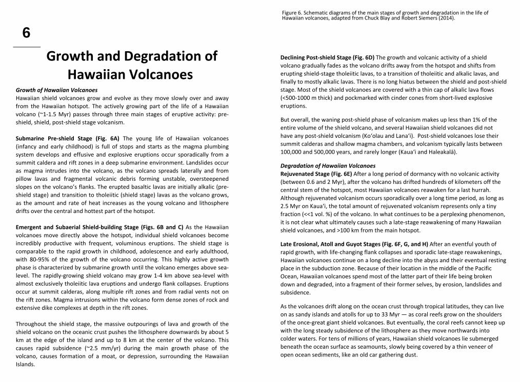
Growth of Hawaiian Volcanoes Hawaiian shield volcanoes grow and evolve as they move slowly over and away from the Hawaiian hotspot. The actively growing part of the life of a Hawaiian volcano (~1‐1.5 Myr) passes through three main stages of eruptive activity: pre‐shield, shield, post‐shield stage volcanism. Submarine Pre‐shield Stage (Fig. 6A) The young life of Hawaiian volcanoes (infancy and early childhood) is full of stops and starts as the magma plumbing system develops and effusive and explosive eruptions occur sporadically from a summit caldera and rift zones in a deep submarine environment. Landslides occur as magma intrudes into the volcano, as the volcano spreads laterally and from pillow lavas and fragmental volcanic debris forming unstable, oversteepened slopes on the volcano’s flanks. The erupted basaltic lavas are initially alkalic (pre‐shield stage) and transition to tholeiitic (shield stage) lavas as the volcano grows, as the amount and rate of heat increases as the young volcano and lithosphere drifts over the central and hottest part of the hotspot. Emergent and Subaerial Shield‐building Stage (Figs. 6B and C) As the Hawaiian volcanoes move directly above the hotspot, individual shield volcanoes become incredibly productive with frequent, voluminous eruptions. The shield stage is comparable to the rapid growth in childhood, adolescence and early adulthood, with 80‐95% of the growth of the volcano occurring. This highly active growth phase is characterized by submarine growth until the volcano emerges above sea‐level. The rapidly‐growing shield volcano may grow 1‐4 km above sea‐level with almost exclusively tholeiitic lava eruptions and undergo flank collapses. Eruptions occur at summit calderas, along multiple rift zones and from radial vents not on the rift zones. Magma intrusions within the volcano form dense zones of rock and extensive dike complexes at depth in the rift zones. Throughout the shield stage, the massive outpourings of lava and growth of the shield volcano on the oceanic crust pushes the lithosphere downwards by about 5 km at the edge of the island and up to 8 km at the center of the volcano. This causes rapid subsidence (~2.5 mm/yr) during the main growth phase of the volcano, causes formation of a moat, or depression, surrounding the Hawaiian Islands.
Growth and Degradation of Hawaiian Volcanoes
6
Figure 6. Schematic diagrams of the main stages of growth and degradation in the life of Hawaiian volcanoes, adapted from Chuck Blay and Robert Siemers (2014).
Declining Post‐shield Stage (Fig. 6D) The growth and volcanic activity of a shield volcano gradually fades as the volcano drifts away from the hotspot and shifts from erupting shield‐stage tholeiitic lavas, to a transition of tholeiitic and alkalic lavas, and finally to mostly alkalic lavas. There is no long hiatus between the shield and post‐shield stage. Most of the shield volcanoes are covered with a thin cap of alkalic lava flows (<500‐1000 m thick) and pockmarked with cinder cones from short‐lived explosive eruptions.
But overall, the waning post‐shield phase of volcanism makes up less than 1% of the entire volume of the shield volcano, and several Hawaiian shield volcanoes did not have any post‐shield volcanism (Ko‘olau and Lana‘i). Post‐shield volcanoes lose their summit calderas and shallow magma chambers, and volcanism typically lasts between 100,000 and 500,000 years, and rarely longer (Kaua‘i and Haleakalā).
Degradation of Hawaiian Volcanoes Rejuvenated Stage (Fig. 6E) After a long period of dormancy with no volcanic activity (between 0.6 and 2 Myr), after the volcano has drifted hundreds of kilometers off the central stem of the hotspot, most Hawaiian volcanoes reawaken for a last hurrah. Although rejuvenated volcanism occurs sporadically over a long time period, as long as 2.5 Myr on Kaua‘i, the total amount of rejuvenated volcanism represents only a tiny fraction (<<1 vol. %) of the volcano. In what continues to be a perplexing phenomenon, it is not clear what ultimately causes such a late‐stage reawakening of many Hawaiian shield volcanoes, and >100 km from the main hotspot.
Late Erosional, Atoll and Guyot Stages (Fig. 6F, G, and H) After an eventful youth of rapid growth, with life‐changing flank collapses and sporadic late‐stage reawakenings, Hawaiian volcanoes continue on a long decline into the abyss and their eventual resting place in the subduction zone. Because of their location in the middle of the Pacific Ocean, Hawaiian volcanoes spend most of the latter part of their life being broken down and degraded, into a fragment of their former selves, by erosion, landslides and subsidence.
As the volcanoes drift along on the ocean crust through tropical latitudes, they can live on as sandy islands and atolls for up to 33 Myr — as coral reefs grow on the shoulders of the once‐great giant shield volcanoes. But eventually, the coral reefs cannot keep up with the long steady subsidence of the lithosphere as they move northwards into colder waters. For tens of millions of years, Hawaiian shield volcanoes lie submerged beneath the ocean surface as seamounts, slowly being covered by a thin veneer of open ocean sediments, like an old car gathering dust.