U.S.C.G. Merchant Marine Exam Limited Operator Uninspected ...
Upload
sabina-holmesCategory
view
216download
0
LCDR Troy Beshears
UAV Platform Manager
United States Coast Guard
U.S.C.G. UAV’s Enhancing the Common U.S.C.G. UAV’s Enhancing the Common Operational Picture Through Emerging Operational Picture Through Emerging
TechnologiesTechnologies

U.S.C.G. 212 Years of Homeland SecurityU.S.C.G. 212 Years of Homeland Security
• UAV Employment techniques to improve maritime domain awareness
• Sensor combinations to extend shipboard detection capabilities while enhancing classification and identification
• Telemetry dissemination and its role in maritime homeland defense
• Improving interoperability among joint agencies through the use of tactical control systems

Territorial Sea
ExclusiveEconomic
Zone
High Seas
Ports & Inland Waterways
Legitimate TradeTransnational Threats
Marine Environmental ProtectionFisheriesOffshore Energy
Port SafetyPort Security
MaritimeSecurityPosture
Pu
sh t
he
bo
rder
ou
t
USCG
UAV Employment techniques to improve UAV Employment techniques to improve Maritime Domain AwarenessMaritime Domain Awareness

• UAV Altitude/Classification• UAV Altitude/Classification
70K
60KGlobal HawkGlobal Hawk
U-2U-2
Heron 1Heron 1
Predator APredator A
Heron 1Heron 1
Predator APredator A
50K
40K
30K
20K
10K
Alti
tude
10
2030
Endurance (hours)
Eagle Eye, Fire scout, Eagle Eye, Fire scout, Hunter, PioneerHunter, Pioneer
Eagle Eye, Fire scout, Eagle Eye, Fire scout, Hunter, PioneerHunter, Pioneer
HAEHAE
MediumMedium
TacticalTactical
Heron 2Heron 2
Predator BPredator B
Heron 2Heron 2
Predator BPredator B

Evaluation of possible deployment Evaluation of possible deployment sites based on UAV Capabilitiessites based on UAV Capabilities
APB05209-18-02

APB05509-18-02
Key to Enhancing Common Operational PictureKey to Enhancing Common Operational Picture
Persistent Presence provided by UAVsPersistent Presence provided by UAVs
Sensor combinations to extend shipboard Sensor combinations to extend shipboard detection capabilities while enhancing detection capabilities while enhancing
classification and identificationclassification and identification
APB020B09-20-02

Why choose an airborne Why choose an airborne surveillance sensor?surveillance sensor?
Large area coverage Remote area coverage High-resolution imagery Long dwell times over areas of interest Readily available technology Flexibility in tasking Ability to operate in hostile environments

Imaging SensorsImaging Sensors
Film & Digital Cameras
Low-light TV Cameras

Imaging SensorsImaging SensorsElectro-optical/Infrared Imagers (EO/IR)
Multispectral ImagersCombine Low Light Images with FLIR
++ ==
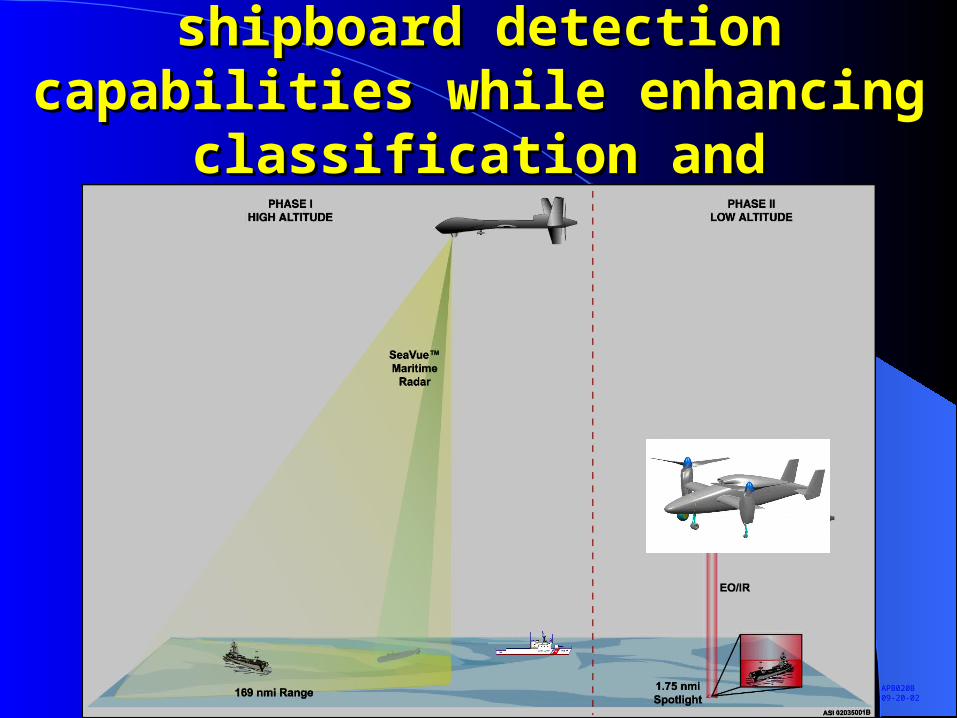
Imaging SensorsImaging SensorsHyperspectral Imagers
Spectral (Z)
Spatial (X)
Spa
tial (
Y)
1000
2000
3000
4000
5000
6000
7000
8000
Wavelength Band
Ref
lect
ance
TreeTruck
0
Blue Green Red Near IR Short Wave IR 0.4 0.5 0.6 0.7 0.8 0.9 1.0 1.1
Hyperspectral Data Cube

Imaging SensorsImaging SensorsSynthetic Aperture Radars (SAR)
Visual Image
SAR Image

Imaging SensorsImaging Sensors Inverse Synthetic Aperture Radars (ISAR)
LIDAR - In the far term, range-gated laser imaging radars (LIDARs) will complement traditional radars by providing the capability to build three-dimensional images in real time of suspected targets found by the latter.
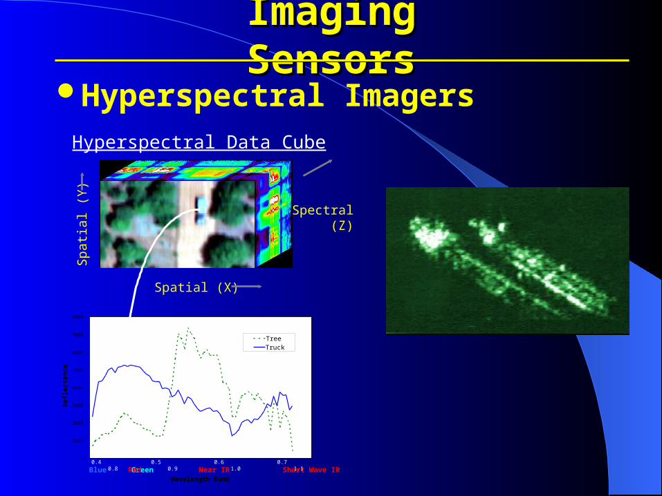
Telemetry Dissemination and its Role Telemetry Dissemination and its Role in Maritime Homeland Defensein Maritime Homeland Defense
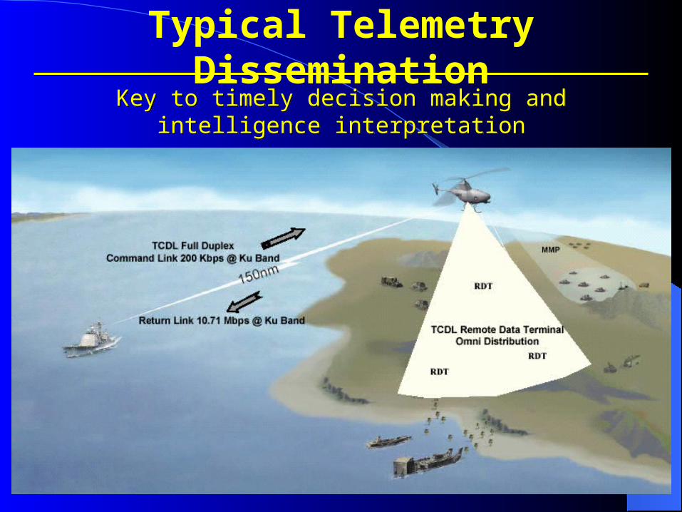
Key to timely decision making and intelligence interpretation
Key to timely decision making and intelligence interpretation
Typical Telemetry Dissemination

TCDL Antenna
Telemetry provides for Command &Control of UAV,
System Health Monitoring,
Single Payload Transmission @ 30fps.
UHF Antenna
Provides Command & Control of UAV,
System Health Monitoring @ 10fps.
IRIDIUM
Commercial Communication Satellite System
Command & Control of UAV, limited Payload.
KU Band
Over the Horizon Satellite Capability, cost effectiveness vs.
availability.
Available Dissemination Capabilities

• Telemetry bandwidth incapable of providing transmission of EO/IR and ISAR payloads simultaneously.
• Can only control one UAV at a time, without switching between platforms.
• Over the Horizon (OTH) operations require that the air vehicle be operated at or above 10,000 agl beyond 110nm. At this altitude most EO/IR sensorsare ineffective at identifying targets of interest.
Shortcomings of Line of Sight (LOS) Antennas

Improving interoperability among joint agencies through the use of tactical control
systems & communications

TACTICAL CONTROL SYSTEMTACTICAL CONTROL SYSTEM
TCS PROVIDES :UAV COMMAND AND CONTROL INTEROPERABILITYSENSOR AND PAYLOAD CONTROLRAPID TARGET/ IMAGERY DISSEMINATION
TCS PROVIDES :UAV COMMAND AND CONTROL INTEROPERABILITYSENSOR AND PAYLOAD CONTROLRAPID TARGET/ IMAGERY DISSEMINATION

LEVEL VLEVEL V
• Launch & Launch & RecoveryRecovery
• Flight Flight ControlControl
• Payload Payload ControlControl
• Direct Data Direct Data ReceiptReceipt
LEVEL IVLEVEL IV
• Flight Flight ControlControl
• Payload Payload ControlControl
• Direct Data Direct Data ReceiptReceipt
LEVEL IIILEVEL III
• Payload Payload ControlControl
• Direct Data Direct Data ReceiptReceipt
LEVEL ILEVEL I
• Secondary Secondary ProductProduct
LEVEL IILEVEL II
• Direct Data Direct Data ReceiptReceipt
TCS Defined Levels Of AV Command and Control
SEMPER PARATUS
Coordinated and Focused on the Real Threats
Prepared for the 21st Century
SEMPER PARATUS
Coordinated and Focused on the Real Threats
Prepared for the 21st Century
Integrated Coast Guard Systems Proprietary Information – Competition Sensitive
QUESTIONS