Layout Designer
1
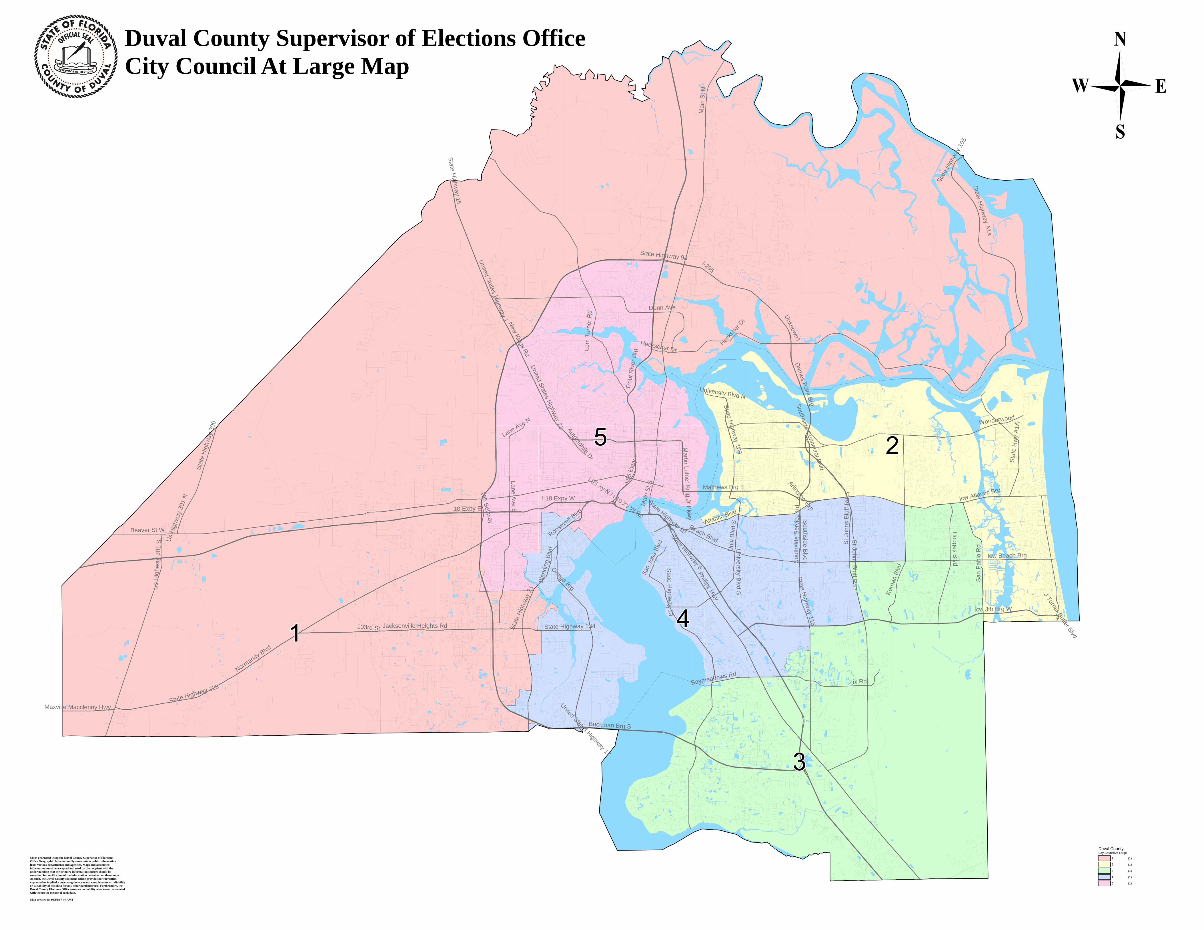
United States Highway 17 S t a t e H i g h w a y 1 3 4 Us Highway 301 N M a x v i l l e M a c c l e n n y H w y B e a v e r S t W Us Highway 301 S Roosevelt Blvd Sta te Highway 2 28 Normandy Blvd State Highway 15 United States Highway 1 295 Beltway Lane Ave N United States Highway 23 Lane Ave S I 1 0 E x p y W Main St N S t at e H ighw ay 9a I-295 Automobile Dr I 95 Expy I 95 Xy N / I 10 Xy W Rp Hec k s c he r Dr Main St S State Highway 10 Martin Luther King Jr Pkwy Hecksher Dr Un ive r s it y B lvd N State Highway 109 Atlanti c B lv d Arlington Exp St Johns Bluff Rd S State Highway 105 State Highway A1a 1 0 3 r d S t State Highway 21 Blanding Blvd Ortega Brg State Highway 5 Phillips Hwy Baymeadow s Rd Univ Blvd S University Blvd S Southside Service Rd Southside Blvd St Johns Bluff Rd I c w B e a c h B r g I cw At la nt i c Brg State Highway 200 B u c k ma n B r g S J Turner Butler Blvd State Highway 115 F ix R d Dames Point Brg Trout River Brg M a t h e ws B r g E I 1 0 E x p y E Southside Connector Blvd I c w J t b B r g W Hodges Blvd Kernan Blvd W on der w ood State Hwy A1A San Pablo Rd D u n n A ve Lem Turner Rd Jacksonville Heights Rd State Highway 13 Duval County Supervisor of Elections Office City Council At Large Map Maps generated using the Duval County Supervisor of Elections Office Geographic Information System contain public information from various departments and agencies. Maps and associated information must be accepted and used by the recipient with the understanding that the primary information sources should be consulted for verification of the information contained on these maps. As such, the Duval County Elections Office provides no warranties, expressed or implied, concerning the accuracy, completeness or reliability or suitability of this data for any other particular use. Furthermore, the Duval County Elections Office assumes no liability whatsoever associated with the use or misuse of such data. Map created on 08/03/17 by AMT Duval County City Council At Large 1 (1) 2 (1) 3 (1) 4 (1) 5 (1)
Transcript of Layout Designer
United States Highway 17
State Highway 134
Us
Hig
hway
301
N
Maxville Macclenny Hwy
Beaver St W
Us
Hig
hway
301
S
Roosevelt Blvd
State Highway 228
Normandy Blvd
State Highw
ay 15
United States H
ighway 1
295 Beltway
Lane Ave N
United States Highway 23
Lane Ave S
I 10 Expy W
Mai
n S
t N
State Highway 9aI-295
Automobile Dr
I 95
Expy
I 95 Xy N / I 10 Xy WRp
Heckscher Dr
Mai
n St
S
State Highway 10
Martin Luther K
ing Jr Pkw
y
Hecks
her D
r
University Blvd N
State Highw
ay 109
Atlantic Blvd
Arlington Exp
St J
ohns
Blu
ff R
d S
Stat
eHi
ghwa
y10
5
State Highw
ay A1a
103rd St Stat
e Hi
ghwa
y 21
Blan
ding
Blv
d
Ortega Brg
State Highway 5Phillips Hwy
Baymeadows Rd
Uni
v Bl
vd S
Univer s ity B
l vd S
Sou
thsi
de S
ervi
ce R
d
So u ths ide B
lv d
St John s B
l uf f Rd
Icw Beach Brg
Icw Atlantic Brg
Stat
e H
ighw
ay 2
00
Buckman Brg S
J Turner Butler Blvd
State Highw
ay 115
Fix Rd
Dam
es Point Brg
Trou
t Riv
er B
rg
Mathews Brg E
I 10 Expy E
Southside Connector Blvd
Icw Jtb Brg W
Hodges B
lvd
Kern
an B
lvd
Wonderwood
Stat
e H
wy
A1A
San
Pab
lo R
d
Dunn Ave
Lem
Tur
ner R
d
Jacksonville Heights Rd
State H
ighway 13
Duval County Supervisor of Elections Office City Council At Large Map
Maps generated using the Duval County Supervisor of Elections Office Geographic Information System contain public information from various departments and agencies. Maps and associated information must be accepted and used by the recipient with theunderstanding that the primary information sources should be consulted for verification of the information contained on these maps. As such, the Duval County Elections Office provides no warranties, expressed or implied, concerning the accuracy, completeness or reliability or suitability of this data for any other particular use. Furthermore, the Duval County Elections Office assumes no liability whatsoever associated with the use or misuse of such data.
Map created on 08/03/17 by AMT
Duval County City Council At Large
1 (1)
2 (1)
3 (1)
4 (1)
5 (1)