Largemouth Bass - Nebraska Game and Parks · most of the lakes contain channel catfish, while...
16
Interstate 80 Lakes Fish Populaon Survey - Page 1 Interstate 80 Lakes — Grand Island to Elm Creek Fish Survey Results - Spring 2013 Brad Eifert, Fisheries Biologist Spanning a stretch of 150 miles along Interstate 80 from Grand Island to Hershey more than 60 small lakes are available for public fishing. Fisheries staff from the Kearney office has the management responsibility for the Interstate lakes located from Grand Island to Elm Creek. These man-made lakes, most of which were created for fill material when the Interstate system was developed in the 1960’s, range in size from 1 to 42 acres. The ground water fed lakes have excellent shoreline access for anglers and usually contain clear water and abundant aquac vegetaon, providing excellent habitat condions for largemouth bass and bluegill. In addion, most of the lakes contain channel caish, while others have crappie, rock bass, walleye, and northern pike. The fish populaons are surveyed on a five year rotaon and the following graphs and text display these results. Largemouth Bass Largemouth bass are present in all of the Interstate lakes in the central poron of Nebraska, with the excepon of War Axe, which has smallmouth bass. Lakes with high densies of smaller bass, include Windmill, Ft. Kearny, West and Middle Mormon Island, Bufflehead, Kea Lake, Coot Shallows, and Sandy Channel #2. Lakes that tradionally produce large bass include Cheyenne, Windmill #1, Bassway Strip, Bufflehead, Blue Hole West, and Sandy Channel #8. Most of the I-80 lakes have a 15-inch minimum length limit on black bass. Excepons include; Mormon Island SRA, Cheyenne, West Wood River, War Axe, and Archway Lakes, all of which have a 21-inch minimum length limit. In addion, Kea West is designated as a catch and release only lake for all species. Anglers are encouraged to pracce catch and release on bass in the I-80 Lakes as they are easily over-harvested. 0 100 200 300 400 500 600 Largemouth bass per hour of electroshocking Interstate 80 Lakes - Grand Island to Elm Creek Largemouth Bass >20 inches 15 - 19.9 inches 12 - 14.9inches 8 - 11.9 inches <8 inches ( ) - year lake was last surveyed
Transcript of Largemouth Bass - Nebraska Game and Parks · most of the lakes contain channel catfish, while...
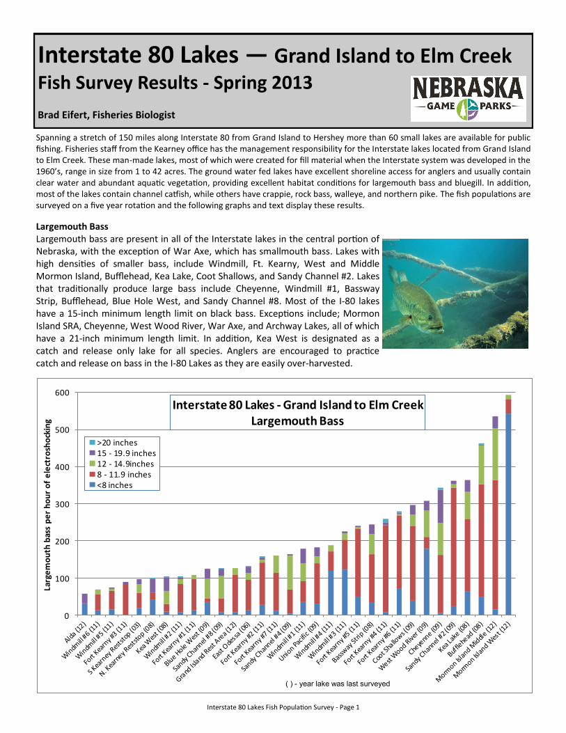
Interstate 80 Lakes Fish Population Survey - Page 1
Interstate 80 Lakes — Grand Island to Elm Creek Fish Survey Results - Spring 2013
Brad Eifert, Fisheries Biologist
Spanning a stretch of 150 miles along Interstate 80 from Grand Island to Hershey more than 60 small lakes are available for public fishing. Fisheries staff from the Kearney office has the management responsibility for the Interstate lakes located from Grand Island to Elm Creek. These man-made lakes, most of which were created for fill material when the Interstate system was developed in the 1960’s, range in size from 1 to 42 acres. The ground water fed lakes have excellent shoreline access for anglers and usually contain clear water and abundant aquatic vegetation, providing excellent habitat conditions for largemouth bass and bluegill. In addition, most of the lakes contain channel catfish, while others have crappie, rock bass, walleye, and northern pike. The fish populations are surveyed on a five year rotation and the following graphs and text display these results.
Largemouth Bass Largemouth bass are present in all of the Interstate lakes in the central portion of Nebraska, with the exception of War Axe, which has smallmouth bass. Lakes with high densities of smaller bass, include Windmill, Ft. Kearny, West and Middle Mormon Island, Bufflehead, Kea Lake, Coot Shallows, and Sandy Channel #2. Lakes that traditionally produce large bass include Cheyenne, Windmill #1, Bassway Strip, Bufflehead, Blue Hole West, and Sandy Channel #8. Most of the I-80 lakes have a 15-inch minimum length limit on black bass. Exceptions include; Mormon Island SRA, Cheyenne, West Wood River, War Axe, and Archway Lakes, all of which have a 21-inch minimum length limit. In addition, Kea West is designated as a catch and release only lake for all species. Anglers are encouraged to practice catch and release on bass in the I-80 Lakes as they are easily over-harvested.
0
100
200
300
400
500
600
Larg
em
ou
th b
ass
pe
r h
ou
r o
f e
lect
rosh
ock
ing
Interstate 80 Lakes - Grand Island to Elm CreekLargemouth Bass
>20 inches15 - 19.9 inches12 - 14.9inches8 - 11.9 inches<8 inches
( ) - year lake was last surveyed
Interstate 80 Lakes Fish Population Survey - Page 2
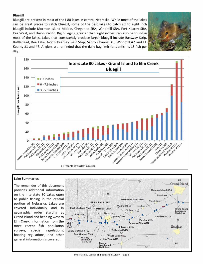
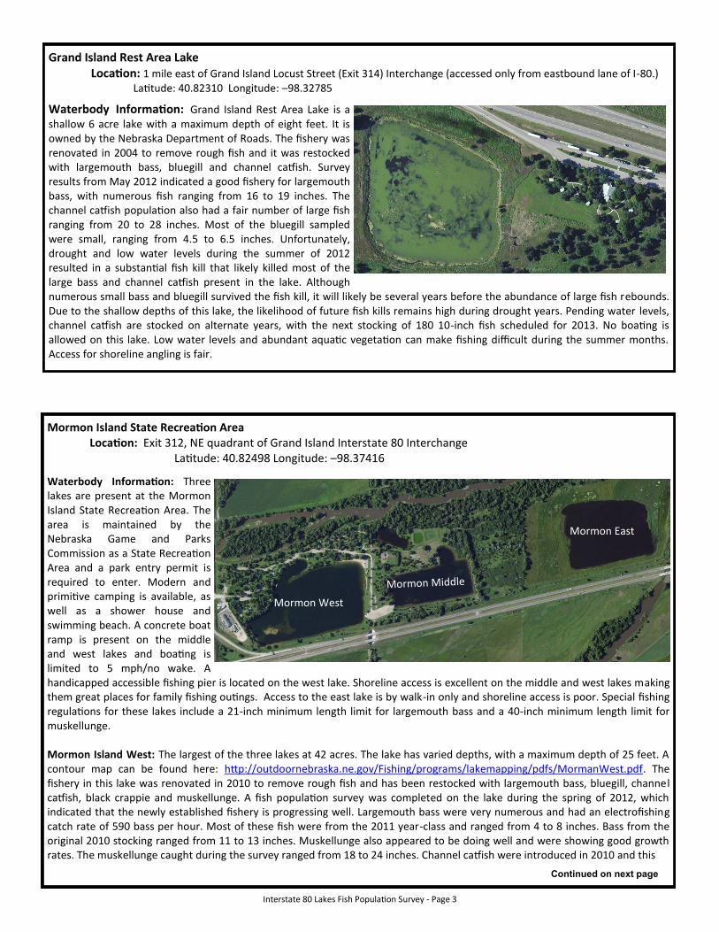
Bluegill Bluegill are present in most of the I-80 lakes in central Nebraska. While most of the lakes can be great places to catch bluegill, some of the best lakes to catch six to eight inch bluegill include Mormon Island Middle, Cheyenne SRA, Windmill SRA, Fort Kearny SRA, Kea West, and Union Pacific. Big bluegills, greater than eight inches, can also be found in most of the lakes. Lakes that consistently produce larger bluegill include Bassway Strip, Bufflehead, Kea Lake, North Kearney Rest Stop, Sandy Channel #8, Windmill #2 and Ft. Kearny #1 and #7. Anglers are reminded that the daily bag limit for panfish is 15 fish per day.
Lake Summaries
The remainder of this document provides additional information on the Interstate 80 Lakes open to public fishing in the central portion of Nebraska. Lakes are covered individually and in geographic order starting at Grand Island and heading west to Elm Creek. Information from the most recent fish population surveys, special regulations, boating regulations, and other general information is covered.
0
20
40
60
80
100
120
140
160
180
blu
egi
ll p
er
fram
e n
et
Interstate 80 Lakes - Grand Island to Elm CreekBluegill
> 8 inches
6 - 7.9 inches
3 - 5.9 inches
( ) - year lake was last surveyed
Interstate 80 Lakes Fish Population Survey - Page 3
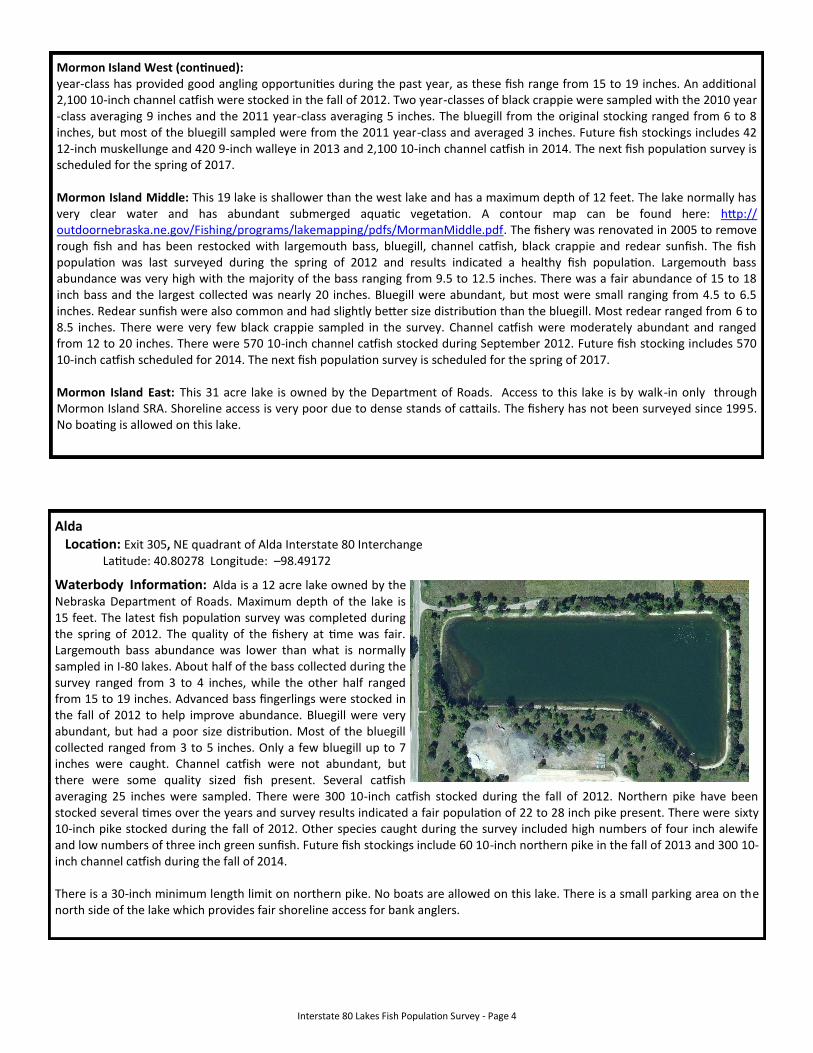
Grand Island Rest Area Lake Location: 1 mile east of Grand Island Locust Street (Exit 314) Interchange (accessed only from eastbound lane of I-80.) Latitude: 40.82310 Longitude: –98.32785
Waterbody Information: Grand Island Rest Area Lake is a shallow 6 acre lake with a maximum depth of eight feet. It is owned by the Nebraska Department of Roads. The fishery was renovated in 2004 to remove rough fish and it was restocked with largemouth bass, bluegill and channel catfish. Survey results from May 2012 indicated a good fishery for largemouth bass, with numerous fish ranging from 16 to 19 inches. The channel catfish population also had a fair number of large fish ranging from 20 to 28 inches. Most of the bluegill sampled were small, ranging from 4.5 to 6.5 inches. Unfortunately, drought and low water levels during the summer of 2012 resulted in a substantial fish kill that likely killed most of the large bass and channel catfish present in the lake. Although numerous small bass and bluegill survived the fish kill, it will likely be several years before the abundance of large fish rebounds. Due to the shallow depths of this lake, the likelihood of future fish kills remains high during drought years. Pending water levels, channel catfish are stocked on alternate years, with the next stocking of 180 10-inch fish scheduled for 2013. No boating is allowed on this lake. Low water levels and abundant aquatic vegetation can make fishing difficult during the summer months. Access for shoreline angling is fair.
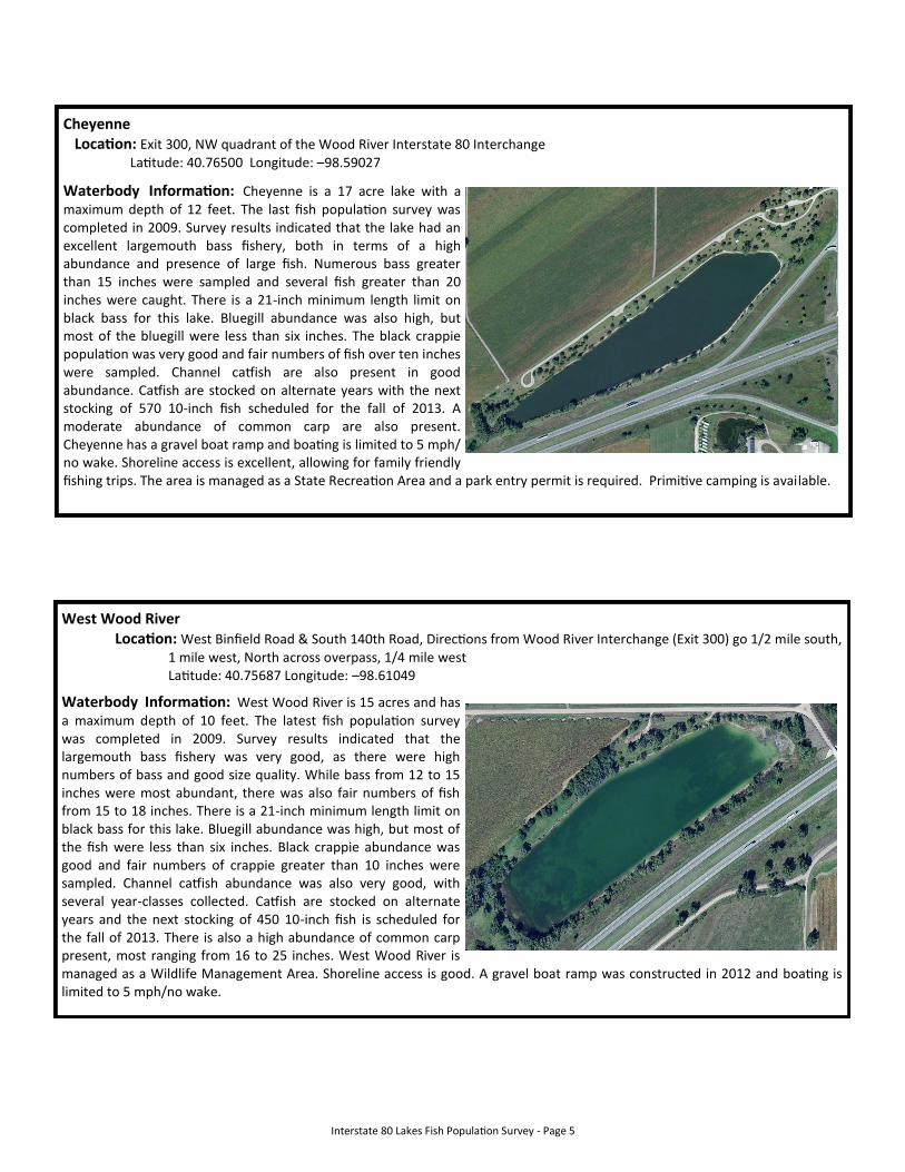
Mormon Island State Recreation Area Location: Exit 312, NE quadrant of Grand Island Interstate 80 Interchange Latitude: 40.82498 Longitude: –98.37416
Waterbody Information: Three lakes are present at the Mormon Island State Recreation Area. The area is maintained by the Nebraska Game and Parks Commission as a State Recreation Area and a park entry permit is required to enter. Modern and primitive camping is available, as well as a shower house and swimming beach. A concrete boat ramp is present on the middle and west lakes and boating is limited to 5 mph/no wake. A handicapped accessible fishing pier is located on the west lake. Shoreline access is excellent on the middle and west lakes making them great places for family fishing outings. Access to the east lake is by walk-in only and shoreline access is poor. Special fishing regulations for these lakes include a 21-inch minimum length limit for largemouth bass and a 40-inch minimum length limit for muskellunge. Mormon Island West: The largest of the three lakes at 42 acres. The lake has varied depths, with a maximum depth of 25 feet. A contour map can be found here: http://outdoornebraska.ne.gov/Fishing/programs/lakemapping/pdfs/MormanWest.pdf. The fishery in this lake was renovated in 2010 to remove rough fish and has been restocked with largemouth bass, bluegill, channel catfish, black crappie and muskellunge. A fish population survey was completed on the lake during the spring of 2012, which indicated that the newly established fishery is progressing well. Largemouth bass were very numerous and had an electrofishing catch rate of 590 bass per hour. Most of these fish were from the 2011 year-class and ranged from 4 to 8 inches. Bass from the original 2010 stocking ranged from 11 to 13 inches. Muskellunge also appeared to be doing well and were showing good growth rates. The muskellunge caught during the survey ranged from 18 to 24 inches. Channel catfish were introduced in 2010 and this
Mormon East
Mormon Middle
Mormon West
Continued on next page
Interstate 80 Lakes Fish Population Survey - Page 4
Mormon Island West (continued): year-class has provided good angling opportunities during the past year, as these fish range from 15 to 19 inches. An additional 2,100 10-inch channel catfish were stocked in the fall of 2012. Two year-classes of black crappie were sampled with the 2010 year-class averaging 9 inches and the 2011 year-class averaging 5 inches. The bluegill from the original stocking ranged from 6 to 8 inches, but most of the bluegill sampled were from the 2011 year-class and averaged 3 inches. Future fish stockings includes 42 12-inch muskellunge and 420 9-inch walleye in 2013 and 2,100 10-inch channel catfish in 2014. The next fish population survey is scheduled for the spring of 2017. Mormon Island Middle: This 19 lake is shallower than the west lake and has a maximum depth of 12 feet. The lake normally has very clear water and has abundant submerged aquatic vegetation. A contour map can be found here: http://outdoornebraska.ne.gov/Fishing/programs/lakemapping/pdfs/MormanMiddle.pdf. The fishery was renovated in 2005 to remove rough fish and has been restocked with largemouth bass, bluegill, channel catfish, black crappie and redear sunfish. The fish population was last surveyed during the spring of 2012 and results indicated a healthy fish population. Largemouth bass abundance was very high with the majority of the bass ranging from 9.5 to 12.5 inches. There was a fair abundance of 15 to 18 inch bass and the largest collected was nearly 20 inches. Bluegill were abundant, but most were small ranging from 4.5 to 6.5 inches. Redear sunfish were also common and had slightly better size distribution than the bluegill. Most redear ranged from 6 to 8.5 inches. There were very few black crappie sampled in the survey. Channel catfish were moderately abundant and ranged from 12 to 20 inches. There were 570 10-inch channel catfish stocked during September 2012. Future fish stocking includes 570 10-inch catfish scheduled for 2014. The next fish population survey is scheduled for the spring of 2017. Mormon Island East: This 31 acre lake is owned by the Department of Roads. Access to this lake is by walk-in only through Mormon Island SRA. Shoreline access is very poor due to dense stands of cattails. The fishery has not been surveyed since 1995. No boating is allowed on this lake.
Alda Location: Exit 305, NE quadrant of Alda Interstate 80 Interchange Latitude: 40.80278 Longitude: –98.49172
Waterbody Information: Alda is a 12 acre lake owned by the Nebraska Department of Roads. Maximum depth of the lake is 15 feet. The latest fish population survey was completed during the spring of 2012. The quality of the fishery at time was fair. Largemouth bass abundance was lower than what is normally sampled in I-80 lakes. About half of the bass collected during the survey ranged from 3 to 4 inches, while the other half ranged from 15 to 19 inches. Advanced bass fingerlings were stocked in the fall of 2012 to help improve abundance. Bluegill were very abundant, but had a poor size distribution. Most of the bluegill collected ranged from 3 to 5 inches. Only a few bluegill up to 7 inches were caught. Channel catfish were not abundant, but there were some quality sized fish present. Several catfish averaging 25 inches were sampled. There were 300 10-inch catfish stocked during the fall of 2012. Northern pike have been stocked several times over the years and survey results indicated a fair population of 22 to 28 inch pike present. There were sixty 10-inch pike stocked during the fall of 2012. Other species caught during the survey included high numbers of four inch alewife and low numbers of three inch green sunfish. Future fish stockings include 60 10-inch northern pike in the fall of 2013 and 300 10-inch channel catfish during the fall of 2014. There is a 30-inch minimum length limit on northern pike. No boats are allowed on this lake. There is a small parking area on the north side of the lake which provides fair shoreline access for bank anglers.
Interstate 80 Lakes Fish Population Survey - Page 5
Cheyenne Location: Exit 300, NW quadrant of the Wood River Interstate 80 Interchange Latitude: 40.76500 Longitude: –98.59027
Waterbody Information: Cheyenne is a 17 acre lake with a maximum depth of 12 feet. The last fish population survey was completed in 2009. Survey results indicated that the lake had an excellent largemouth bass fishery, both in terms of a high abundance and presence of large fish. Numerous bass greater than 15 inches were sampled and several fish greater than 20 inches were caught. There is a 21-inch minimum length limit on black bass for this lake. Bluegill abundance was also high, but most of the bluegill were less than six inches. The black crappie population was very good and fair numbers of fish over ten inches were sampled. Channel catfish are also present in good abundance. Catfish are stocked on alternate years with the next stocking of 570 10-inch fish scheduled for the fall of 2013. A moderate abundance of common carp are also present. Cheyenne has a gravel boat ramp and boating is limited to 5 mph/no wake. Shoreline access is excellent, allowing for family friendly fishing trips. The area is managed as a State Recreation Area and a park entry permit is required. Primitive camping is available.
West Wood River Location: West Binfield Road & South 140th Road, Directions from Wood River Interchange (Exit 300) go 1/2 mile south, 1 mile west, North across overpass, 1/4 mile west Latitude: 40.75687 Longitude: –98.61049
Waterbody Information: West Wood River is 15 acres and has a maximum depth of 10 feet. The latest fish population survey was completed in 2009. Survey results indicated that the largemouth bass fishery was very good, as there were high numbers of bass and good size quality. While bass from 12 to 15 inches were most abundant, there was also fair numbers of fish from 15 to 18 inches. There is a 21-inch minimum length limit on black bass for this lake. Bluegill abundance was high, but most of the fish were less than six inches. Black crappie abundance was good and fair numbers of crappie greater than 10 inches were sampled. Channel catfish abundance was also very good, with several year-classes collected. Catfish are stocked on alternate years and the next stocking of 450 10-inch fish is scheduled for the fall of 2013. There is also a high abundance of common carp present, most ranging from 16 to 25 inches. West Wood River is managed as a Wildlife Management Area. Shoreline access is good. A gravel boat ramp was constructed in 2012 and boating is limited to 5 mph/no wake.
Interstate 80 Lakes Fish Population Survey - Page 6
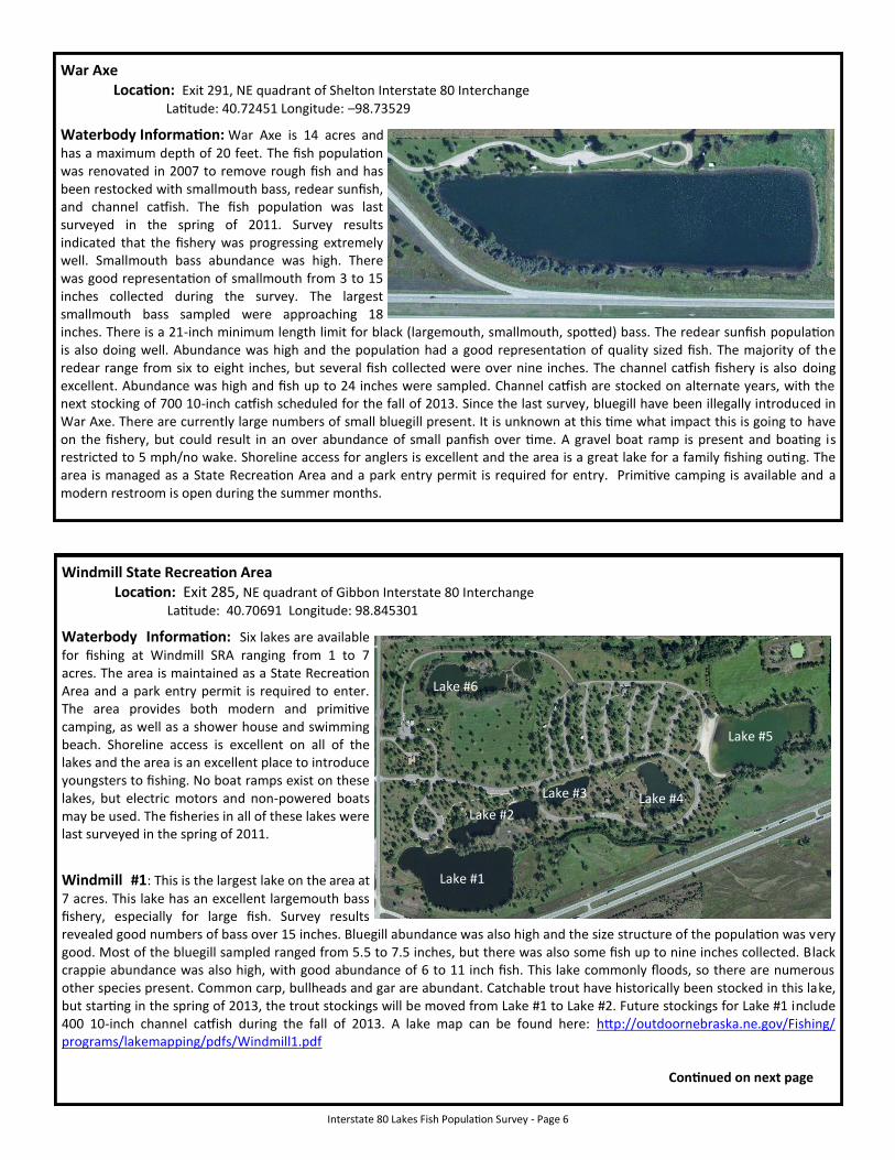
War Axe Location: Exit 291, NE quadrant of Shelton Interstate 80 Interchange Latitude: 40.72451 Longitude: –98.73529
Waterbody Information: War Axe is 14 acres and has a maximum depth of 20 feet. The fish population was renovated in 2007 to remove rough fish and has been restocked with smallmouth bass, redear sunfish, and channel catfish. The fish population was last surveyed in the spring of 2011. Survey results indicated that the fishery was progressing extremely well. Smallmouth bass abundance was high. There was good representation of smallmouth from 3 to 15 inches collected during the survey. The largest smallmouth bass sampled were approaching 18 inches. There is a 21-inch minimum length limit for black (largemouth, smallmouth, spotted) bass. The redear sunfish population is also doing well. Abundance was high and the population had a good representation of quality sized fish. The majority of the redear range from six to eight inches, but several fish collected were over nine inches. The channel catfish fishery is also doing excellent. Abundance was high and fish up to 24 inches were sampled. Channel catfish are stocked on alternate years, with the next stocking of 700 10-inch catfish scheduled for the fall of 2013. Since the last survey, bluegill have been illegally introduced in War Axe. There are currently large numbers of small bluegill present. It is unknown at this time what impact this is going to have on the fishery, but could result in an over abundance of small panfish over time. A gravel boat ramp is present and boating is restricted to 5 mph/no wake. Shoreline access for anglers is excellent and the area is a great lake for a family fishing outing. The area is managed as a State Recreation Area and a park entry permit is required for entry. Primitive camping is available and a modern restroom is open during the summer months.
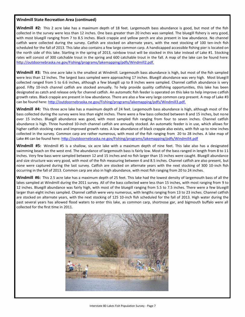
Windmill State Recreation Area Location: Exit 285, NE quadrant of Gibbon Interstate 80 Interchange Latitude: 40.70691 Longitude: 98.845301
Waterbody Information: Six lakes are available for fishing at Windmill SRA ranging from 1 to 7 acres. The area is maintained as a State Recreation Area and a park entry permit is required to enter. The area provides both modern and primitive camping, as well as a shower house and swimming beach. Shoreline access is excellent on all of the lakes and the area is an excellent place to introduce youngsters to fishing. No boat ramps exist on these lakes, but electric motors and non-powered boats may be used. The fisheries in all of these lakes were last surveyed in the spring of 2011.
Windmill #1: This is the largest lake on the area at 7 acres. This lake has an excellent largemouth bass fishery, especially for large fish. Survey results revealed good numbers of bass over 15 inches. Bluegill abundance was also high and the size structure of the population was very good. Most of the bluegill sampled ranged from 5.5 to 7.5 inches, but there was also some fish up to nine inches collected. Black crappie abundance was also high, with good abundance of 6 to 11 inch fish. This lake commonly floods, so there are numerous other species present. Common carp, bullheads and gar are abundant. Catchable trout have historically been stocked in this lake, but starting in the spring of 2013, the trout stockings will be moved from Lake #1 to Lake #2. Future stockings for Lake #1 include 400 10-inch channel catfish during the fall of 2013. A lake map can be found here: http://outdoornebraska.ne.gov/Fishing/programs/lakemapping/pdfs/Windmill1.pdf Continued on next page
Lake #5
Lake #4
Lake #1
Lake #6
Lake #3
Lake #2
Interstate 80 Lakes Fish Population Survey - Page 7
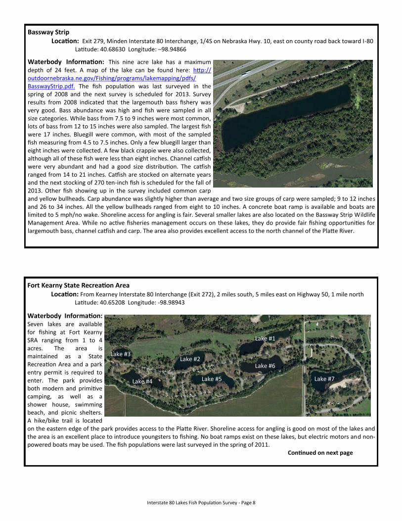
Windmill State Recreation Area (continued)
Windmill #2: This 2 acre lake has a maximum depth of 18 feet. Largemouth bass abundance is good, but most of the fish collected in the survey were less than 12 inches. One bass greater than 20 inches was sampled. The bluegill fishery is very good, with most bluegill ranging from 7 to 8.5 inches. Black crappie and yellow perch are also present in low abundance. No channel catfish were collected during the survey. Catfish are stocked on alternate years, with the next stocking of 100 ten-inch fish scheduled for the fall of 2013. This lake also contains a few large common carp. A handicapped accessible fishing pier is located on the north side of this lake. Starting in the spring of 2013, rainbow trout will be stocked in this lake instead of Lake #1. Stocking rates will consist of 300 catchable trout in the spring and 600 catchable trout in the fall. A map of the lake can be found here: http://outdoornebraska.ne.gov/Fishing/programs/lakemapping/pdfs/Windmill2.pdf.
Windmill #3: This one acre lake is the smallest at Windmill. Largemouth bass abundance is high, but most of the fish sampled were less than 12 inches. The largest bass sampled were approaching 17 inches. Bluegill abundance was very high. Most bluegill collected ranged from 5 to 6.6 inches, although a few bluegill up to 8 inches were sampled. Channel catfish abundance is very good. Fifty 10-inch channel catfish are stocked annually. To help provide quality catfishing opportunities, this lake has been designated as catch and release only for channel catfish. An automatic fish feeder is operated on this lake to help improve catfish growth rates. Black crappie are present in low abundance. There are also a few very large common carp present. A map of Lake #3 can be found here: http://outdoornebraska.ne.gov/Fishing/programs/lakemapping/pdfs/Windmill3.pdf.
Windmill #4: This three acre lake has a maximum depth of 24 feet. Largemouth bass abundance is high, although most of the bass collected during the survey were less than eight inches. There were a few bass collected between 8 and 15 inches, but none over 15 inches. Bluegill abundance was good, with most sampled fish ranging from four to seven inches. Channel catfish abundance is high. Three hundred 10-inch channel catfish are annually stocked. An automatic feeder is in use, which allows for higher catfish stocking rates and improved growth rates. A low abundance of black crappie also exists, with fish up to nine inches collected in the survey. Common carp are rather numerous, with most of the fish ranging from 20 to 28 inches. A lake map of Lake #4 can be found here: http://outdoornebraska.ne.gov/Fishing/programs/lakemapping/pdfs/Windmill4.pdf
Windmill #5: Windmill #5 is a shallow, six acre lake with a maximum depth of nine feet. This lake also has a designated swimming beach on the west end. The abundance of largemouth bass is fairly low. Most of the bass ranged in length from 8 to 11 inches. Very few bass were sampled between 12 and 15 inches and no fish larger than 15 inches were caught. Bluegill abundance and size structure was very good, with most of the fish measuring between 6 and 8.5 inches. Channel catfish are also present, but none were captured during the last survey. Catfish are stocked on alternate years with the next stocking of 300 10-inch fish occurring in the fall of 2013. Common carp are also in high abundance, with most fish ranging from 20 to 24 inches.
Windmill #6: This 2.5 acre lake has a maximum depth of 25 feet. This lake had the lowest density of largemouth bass of all the lakes sampled at Windmill during the 2011 survey. All of the bass collected were less than 15 inches, with most ranging from 9 to 12 inches. Bluegill abundance was fairly high, with most of the bluegill ranging from 5.5 to 7.5 inches. There were a few bluegill larger than eight inches sampled. Channel catfish were very numerous, with lengths ranging from 13 to 23 inches. Channel catfish are stocked on alternate years, with the next stocking of 125 10-inch fish scheduled for the fall of 2013. High water during the past several years has allowed flood waters to enter this lake, as common carp, shortnose gar, and bigmouth buffalo were all collected for the first time in 2011.
Interstate 80 Lakes Fish Population Survey - Page 8
Bassway Strip Location: Exit 279, Minden Interstate 80 Interchange, 1/4S on Nebraska Hwy. 10, east on county road back toward I-80 Latitude: 40.68630 Longitude: –98.94866
Waterbody Information: This nine acre lake has a maximum depth of 24 feet. A map of the lake can be found here: http://outdoornebraska.ne.gov/Fishing/programs/lakemapping/pdfs/BasswayStrip.pdf. The fish population was last surveyed in the spring of 2008 and the next survey is scheduled for 2013. Survey results from 2008 indicated that the largemouth bass fishery was very good. Bass abundance was high and fish were sampled in all size categories. While bass from 7.5 to 9 inches were most common, lots of bass from 12 to 15 inches were also sampled. The largest fish were 17 inches. Bluegill were common, with most of the sampled fish measuring from 4.5 to 7.5 inches. Only a few bluegill larger than eight inches were collected. A few black crappie were also collected, although all of these fish were less than eight inches. Channel catfish were very abundant and had a good size distribution. The catfish ranged from 14 to 21 inches. Catfish are stocked on alternate years and the next stocking of 270 ten-inch fish is scheduled for the fall of 2013. Other fish showing up in the survey included common carp and yellow bullheads. Carp abundance was slightly higher than average and two size groups of carp were sampled; 9 to 12 inches and 26 to 34 inches. All the yellow bullheads ranged from eight to 10 inches. A concrete boat ramp is available and boats are limited to 5 mph/no wake. Shoreline access for angling is fair. Several smaller lakes are also located on the Bassway Strip Wildlife Management Area. While no active fisheries management occurs on these lakes, they do provide fair fishing opportunities for largemouth bass, channel catfish and carp. The area also provides excellent access to the north channel of the Platte River.
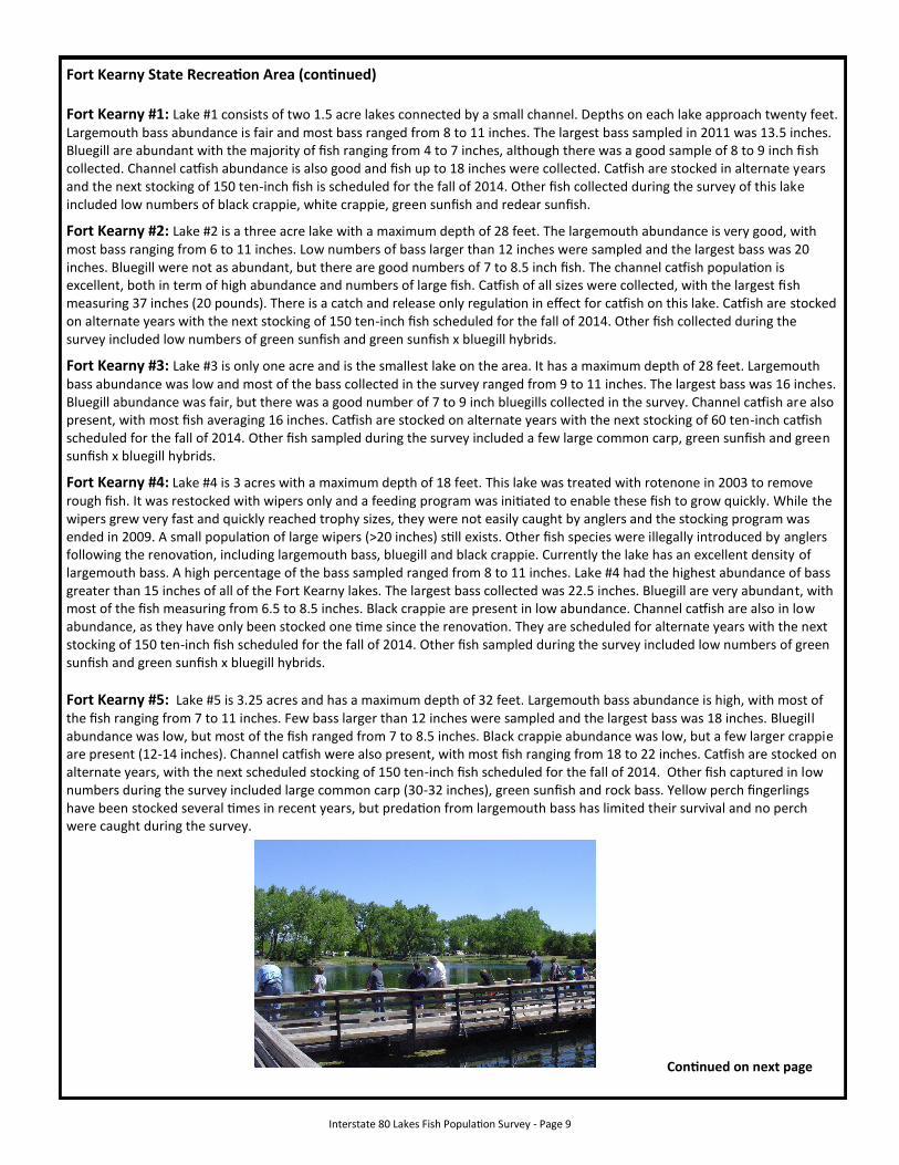
Fort Kearny State Recreation Area Location: From Kearney Interstate 80 Interchange (Exit 272), 2 miles south, 5 miles east on Highway 50, 1 mile north Latitude: 40.65208 Longitude: -98.98943
Waterbody Information: Seven lakes are available for fishing at Fort Kearny SRA ranging from 1 to 4 acres. The area is maintained as a State Recreation Area and a park entry permit is required to enter. The park provides both modern and primitive camping, as well as a shower house, swimming beach, and picnic shelters. A hike/bike trail is located on the eastern edge of the park provides access to the Platte River. Shoreline access for angling is good on most of the lakes and the area is an excellent place to introduce youngsters to fishing. No boat ramps exist on these lakes, but electric motors and non-powered boats may be used. The fish populations were last surveyed in the spring of 2011. Continued on next page
Lake #3
Lake #4
Lake #2
Lake #5 Lake #7
Lake #6
Lake #1
Interstate 80 Lakes Fish Population Survey - Page 9
Fort Kearny State Recreation Area (continued) Fort Kearny #1: Lake #1 consists of two 1.5 acre lakes connected by a small channel. Depths on each lake approach twenty feet. Largemouth bass abundance is fair and most bass ranged from 8 to 11 inches. The largest bass sampled in 2011 was 13.5 inches. Bluegill are abundant with the majority of fish ranging from 4 to 7 inches, although there was a good sample of 8 to 9 inch fish collected. Channel catfish abundance is also good and fish up to 18 inches were collected. Catfish are stocked in alternate years and the next stocking of 150 ten-inch fish is scheduled for the fall of 2014. Other fish collected during the survey of this lake included low numbers of black crappie, white crappie, green sunfish and redear sunfish.
Fort Kearny #2: Lake #2 is a three acre lake with a maximum depth of 28 feet. The largemouth abundance is very good, with most bass ranging from 6 to 11 inches. Low numbers of bass larger than 12 inches were sampled and the largest bass was 20 inches. Bluegill were not as abundant, but there are good numbers of 7 to 8.5 inch fish. The channel catfish population is excellent, both in term of high abundance and numbers of large fish. Catfish of all sizes were collected, with the largest fish measuring 37 inches (20 pounds). There is a catch and release only regulation in effect for catfish on this lake. Catfish are stocked on alternate years with the next stocking of 150 ten-inch fish scheduled for the fall of 2014. Other fish collected during the survey included low numbers of green sunfish and green sunfish x bluegill hybrids.
Fort Kearny #3: Lake #3 is only one acre and is the smallest lake on the area. It has a maximum depth of 28 feet. Largemouth bass abundance was low and most of the bass collected in the survey ranged from 9 to 11 inches. The largest bass was 16 inches. Bluegill abundance was fair, but there was a good number of 7 to 9 inch bluegills collected in the survey. Channel catfish are also present, with most fish averaging 16 inches. Catfish are stocked on alternate years with the next stocking of 60 ten-inch catfish scheduled for the fall of 2014. Other fish sampled during the survey included a few large common carp, green sunfish and green sunfish x bluegill hybrids.
Fort Kearny #4: Lake #4 is 3 acres with a maximum depth of 18 feet. This lake was treated with rotenone in 2003 to remove rough fish. It was restocked with wipers only and a feeding program was initiated to enable these fish to grow quickly. While the wipers grew very fast and quickly reached trophy sizes, they were not easily caught by anglers and the stocking program was ended in 2009. A small population of large wipers (>20 inches) still exists. Other fish species were illegally introduced by anglers following the renovation, including largemouth bass, bluegill and black crappie. Currently the lake has an excellent density of largemouth bass. A high percentage of the bass sampled ranged from 8 to 11 inches. Lake #4 had the highest abundance of bass greater than 15 inches of all of the Fort Kearny lakes. The largest bass collected was 22.5 inches. Bluegill are very abundant, with most of the fish measuring from 6.5 to 8.5 inches. Black crappie are present in low abundance. Channel catfish are also in low abundance, as they have only been stocked one time since the renovation. They are scheduled for alternate years with the next stocking of 150 ten-inch fish scheduled for the fall of 2014. Other fish sampled during the survey included low numbers of green sunfish and green sunfish x bluegill hybrids.
Fort Kearny #5: Lake #5 is 3.25 acres and has a maximum depth of 32 feet. Largemouth bass abundance is high, with most of the fish ranging from 7 to 11 inches. Few bass larger than 12 inches were sampled and the largest bass was 18 inches. Bluegill abundance was low, but most of the fish ranged from 7 to 8.5 inches. Black crappie abundance was low, but a few larger crappie are present (12-14 inches). Channel catfish were also present, with most fish ranging from 18 to 22 inches. Catfish are stocked on alternate years, with the next scheduled stocking of 150 ten-inch fish scheduled for the fall of 2014. Other fish captured in low numbers during the survey included large common carp (30-32 inches), green sunfish and rock bass. Yellow perch fingerlings have been stocked several times in recent years, but predation from largemouth bass has limited their survival and no perch were caught during the survey.
Continued on next page
Interstate 80 Lakes Fish Population Survey - Page 10
Fort Kearny State Recreation Area (continued)
Fort Kearny #6: Lake #6 is 3.75 acres and has a maximum depth of 20 feet. This lake had the highest density of largemouth bass out of all of the Fort Kearny lakes. Most of the bass ranged from 7 to 10.5 inches. Only a few fish larger than 12 inches were sampled and the largest bass collected was 21.5 inches. Bluegill abundance was also the highest of all of the Fort Kearny Lakes. Most of the bluegill ranged from 5 to 7 inches, although there were a few larger than 8 inches. Channel catfish abundance is very high on this lake due to an intensive stocking and feeding program. There are a 375 ten-inch catfish annually stocked and an automatic fish feeder is normally ran from May through October. Most of the catfish range from 15 to 22 inches, but fish up to 40 inches (28 pounds) have been caught from this lake. Beginning in March 2013, catchable-sized rainbow trout will be stocked in Lake #6 during March and October. There will be 600 trout stocked in March and 1,200 trout stocked in October. Other fish encountered during the survey included low numbers of black bullheads and green sunfish. A handicapped accessible fishing pier is located on the south side of Lake #6.
Fort Kearny #7: Lake #7 is 3.5 acres and has a maximum depth of 28 feet. This lake has a designated public swimming beach on the south side. Shoreline access is poor around most of the lake, but a handicapped accessible pier is located on the northeast corner. Largemouth bass abundance is high, with most of the bass collected measuring from 7 to 12.5 inches. Few bass larger than 12 inches were sampled and the largest bass was 15.5 inches. Bluegill abundance was good, with most of the fish ranging from 3 to 6 inches. Although few bluegill larger than eight inches were collected during the latest survey, Lake #7 has traditionally produced bluegills up to 10 inches. Channel catfish abundance was very high and lengths ranged from 11 to 27 inches. Catfish are stocked on alternate years, with the next scheduled stocking of 175 ten-inch fish scheduled for the fall of 2014. Other fish captured in the survey included a few 30-34” common carp and small green sunfish.
Bufflehead Location: From Kearney Interchange (Exit 272), 1 mile north to 11th Street, 3 miles east to Cherry Avenue, 1 mile south, 1/2 m east
Latitude: 40.67087 Longitude: -99.01802
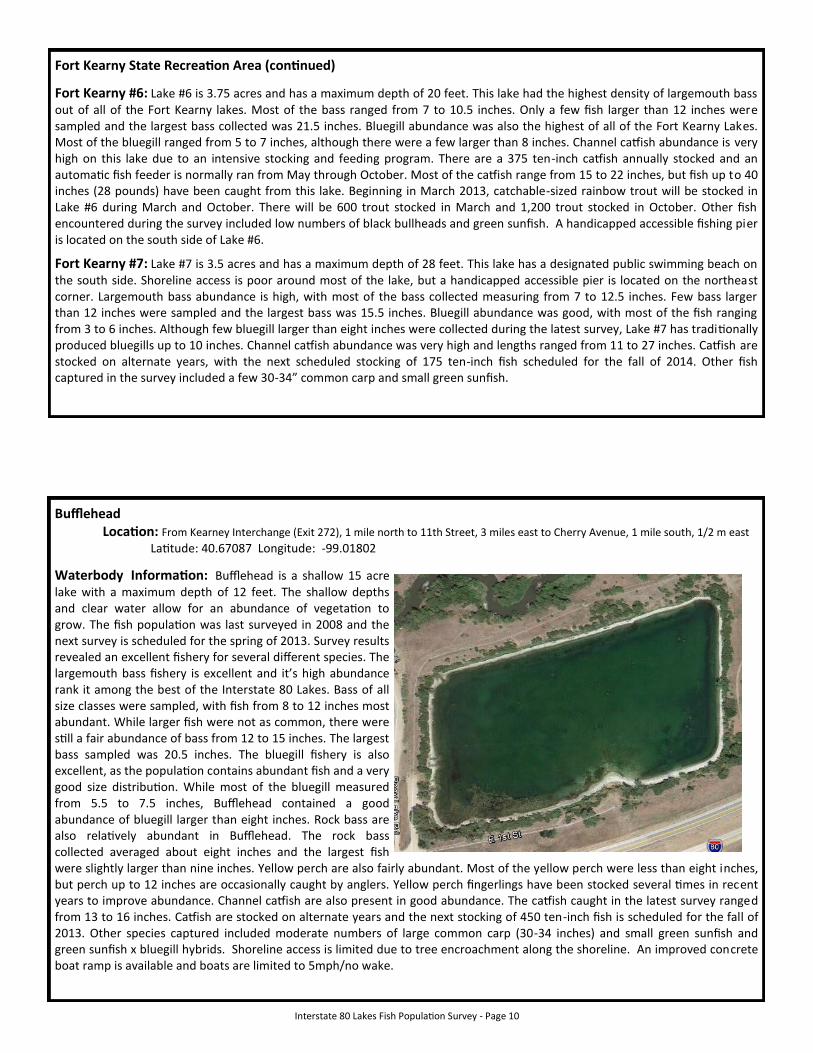
Waterbody Information: Bufflehead is a shallow 15 acre lake with a maximum depth of 12 feet. The shallow depths and clear water allow for an abundance of vegetation to grow. The fish population was last surveyed in 2008 and the next survey is scheduled for the spring of 2013. Survey results revealed an excellent fishery for several different species. The largemouth bass fishery is excellent and it’s high abundance rank it among the best of the Interstate 80 Lakes. Bass of all size classes were sampled, with fish from 8 to 12 inches most abundant. While larger fish were not as common, there were still a fair abundance of bass from 12 to 15 inches. The largest bass sampled was 20.5 inches. The bluegill fishery is also excellent, as the population contains abundant fish and a very good size distribution. While most of the bluegill measured from 5.5 to 7.5 inches, Bufflehead contained a good abundance of bluegill larger than eight inches. Rock bass are also relatively abundant in Bufflehead. The rock bass collected averaged about eight inches and the largest fish were slightly larger than nine inches. Yellow perch are also fairly abundant. Most of the yellow perch were less than eight inches, but perch up to 12 inches are occasionally caught by anglers. Yellow perch fingerlings have been stocked several times in recent years to improve abundance. Channel catfish are also present in good abundance. The catfish caught in the latest survey ranged from 13 to 16 inches. Catfish are stocked on alternate years and the next stocking of 450 ten-inch fish is scheduled for the fall of 2013. Other species captured included moderate numbers of large common carp (30-34 inches) and small green sunfish and green sunfish x bluegill hybrids. Shoreline access is limited due to tree encroachment along the shoreline. An improved concrete boat ramp is available and boats are limited to 5mph/no wake.
Interstate 80 Lakes Fish Population Survey - Page 11
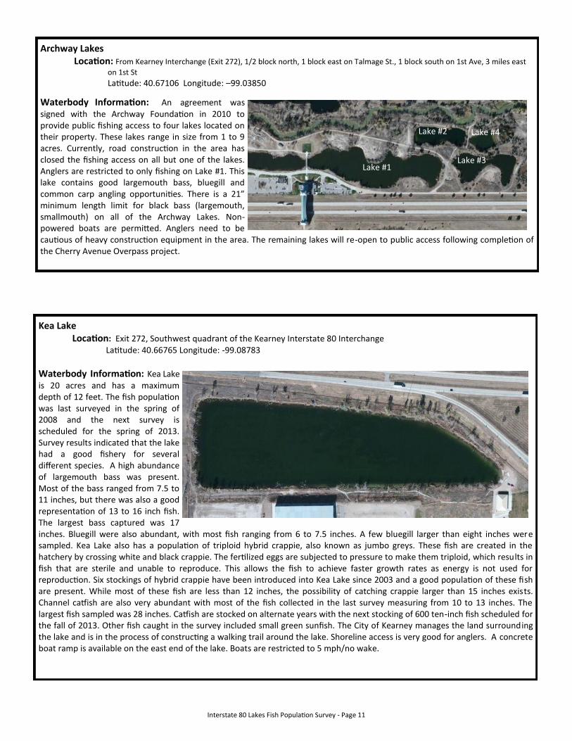
Archway Lakes Location: From Kearney Interchange (Exit 272), 1/2 block north, 1 block east on Talmage St., 1 block south on 1st Ave, 3 miles east
on 1st St
Latitude: 40.67106 Longitude: –99.03850
Waterbody Information: An agreement was signed with the Archway Foundation in 2010 to provide public fishing access to four lakes located on their property. These lakes range in size from 1 to 9 acres. Currently, road construction in the area has closed the fishing access on all but one of the lakes. Anglers are restricted to only fishing on Lake #1. This lake contains good largemouth bass, bluegill and common carp angling opportunities. There is a 21” minimum length limit for black bass (largemouth, smallmouth) on all of the Archway Lakes. Non-powered boats are permitted. Anglers need to be cautious of heavy construction equipment in the area. The remaining lakes will re-open to public access following completion of the Cherry Avenue Overpass project.
Lake #1
Lake #2
Lake #3
Lake #4
Kea Lake Location: Exit 272, Southwest quadrant of the Kearney Interstate 80 Interchange Latitude: 40.66765 Longitude: -99.08783
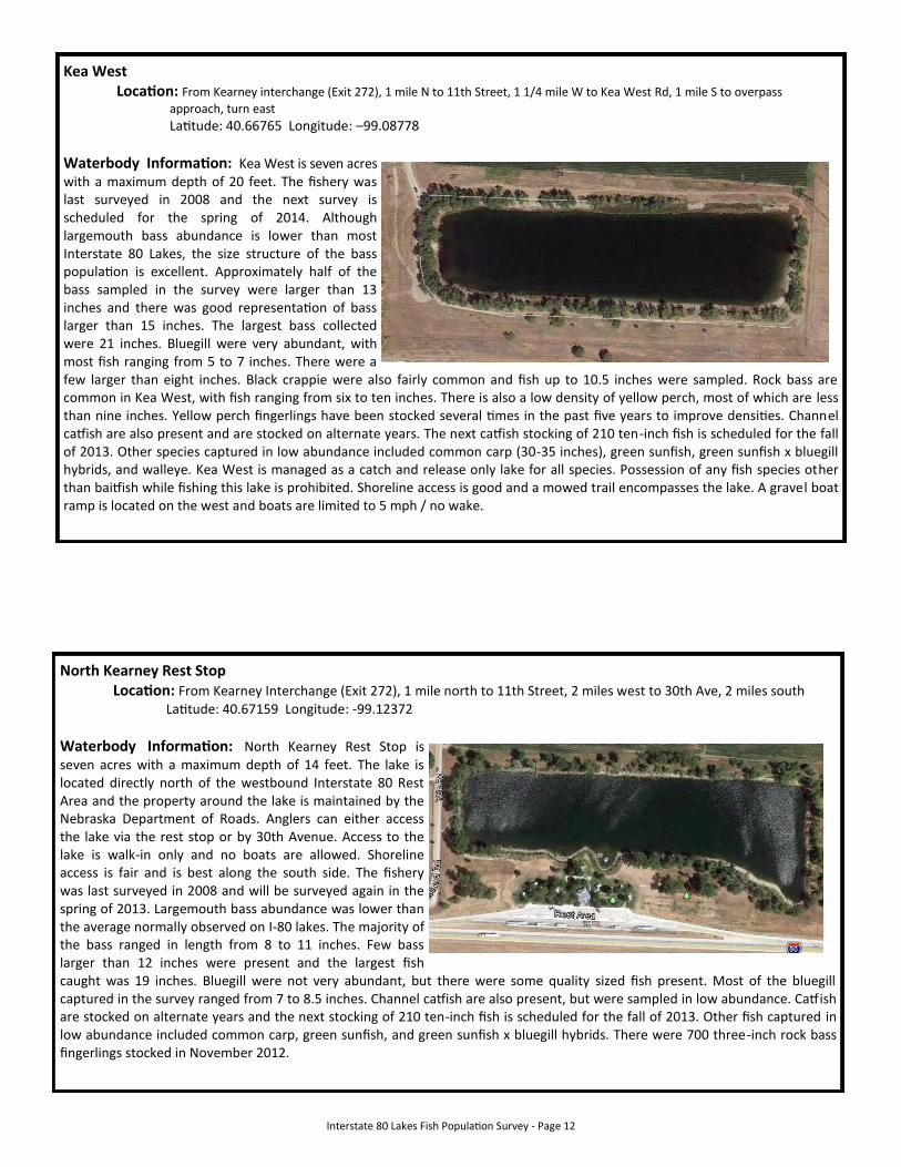
Waterbody Information: Kea Lake is 20 acres and has a maximum depth of 12 feet. The fish population was last surveyed in the spring of 2008 and the next survey is scheduled for the spring of 2013. Survey results indicated that the lake had a good fishery for several different species. A high abundance of largemouth bass was present. Most of the bass ranged from 7.5 to 11 inches, but there was also a good representation of 13 to 16 inch fish. The largest bass captured was 17 inches. Bluegill were also abundant, with most fish ranging from 6 to 7.5 inches. A few bluegill larger than eight inches were sampled. Kea Lake also has a population of triploid hybrid crappie, also known as jumbo greys. These fish are created in the hatchery by crossing white and black crappie. The fertilized eggs are subjected to pressure to make them triploid, which results in fish that are sterile and unable to reproduce. This allows the fish to achieve faster growth rates as energy is not used for reproduction. Six stockings of hybrid crappie have been introduced into Kea Lake since 2003 and a good population of these fish are present. While most of these fish are less than 12 inches, the possibility of catching crappie larger than 15 inches exists. Channel catfish are also very abundant with most of the fish collected in the last survey measuring from 10 to 13 inches. The largest fish sampled was 28 inches. Catfish are stocked on alternate years with the next stocking of 600 ten-inch fish scheduled for the fall of 2013. Other fish caught in the survey included small green sunfish. The City of Kearney manages the land surrounding the lake and is in the process of constructing a walking trail around the lake. Shoreline access is very good for anglers. A concrete boat ramp is available on the east end of the lake. Boats are restricted to 5 mph/no wake.
Interstate 80 Lakes Fish Population Survey - Page 12
Kea West Location: From Kearney interchange (Exit 272), 1 mile N to 11th Street, 1 1/4 mile W to Kea West Rd, 1 mile S to overpass
approach, turn east
Latitude: 40.66765 Longitude: –99.08778
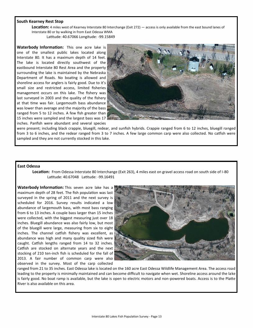
Waterbody Information: Kea West is seven acres with a maximum depth of 20 feet. The fishery was last surveyed in 2008 and the next survey is scheduled for the spring of 2014. Although largemouth bass abundance is lower than most Interstate 80 Lakes, the size structure of the bass population is excellent. Approximately half of the bass sampled in the survey were larger than 13 inches and there was good representation of bass larger than 15 inches. The largest bass collected were 21 inches. Bluegill were very abundant, with most fish ranging from 5 to 7 inches. There were a few larger than eight inches. Black crappie were also fairly common and fish up to 10.5 inches were sampled. Rock bass are common in Kea West, with fish ranging from six to ten inches. There is also a low density of yellow perch, most of which are less than nine inches. Yellow perch fingerlings have been stocked several times in the past five years to improve densities. Channel catfish are also present and are stocked on alternate years. The next catfish stocking of 210 ten-inch fish is scheduled for the fall of 2013. Other species captured in low abundance included common carp (30-35 inches), green sunfish, green sunfish x bluegill hybrids, and walleye. Kea West is managed as a catch and release only lake for all species. Possession of any fish species other than baitfish while fishing this lake is prohibited. Shoreline access is good and a mowed trail encompasses the lake. A gravel boat ramp is located on the west and boats are limited to 5 mph / no wake.
North Kearney Rest Stop Location: From Kearney Interchange (Exit 272), 1 mile north to 11th Street, 2 miles west to 30th Ave, 2 miles south Latitude: 40.67159 Longitude: -99.12372
Waterbody Information: North Kearney Rest Stop is seven acres with a maximum depth of 14 feet. The lake is located directly north of the westbound Interstate 80 Rest Area and the property around the lake is maintained by the Nebraska Department of Roads. Anglers can either access the lake via the rest stop or by 30th Avenue. Access to the lake is walk-in only and no boats are allowed. Shoreline access is fair and is best along the south side. The fishery was last surveyed in 2008 and will be surveyed again in the spring of 2013. Largemouth bass abundance was lower than the average normally observed on I-80 lakes. The majority of the bass ranged in length from 8 to 11 inches. Few bass larger than 12 inches were present and the largest fish caught was 19 inches. Bluegill were not very abundant, but there were some quality sized fish present. Most of the bluegill captured in the survey ranged from 7 to 8.5 inches. Channel catfish are also present, but were sampled in low abundance. Catfish are stocked on alternate years and the next stocking of 210 ten-inch fish is scheduled for the fall of 2013. Other fish captured in low abundance included common carp, green sunfish, and green sunfish x bluegill hybrids. There were 700 three-inch rock bass fingerlings stocked in November 2012.
Interstate 80 Lakes Fish Population Survey - Page 13
South Kearney Rest Stop Location: 4 miles west of Kearney Interstate 80 Interchange (Exit 272) — access is only available from the east bound lanes of
Interstate 80 or by walking in from East Odessa WMA Latitude: 40.67066 Longitude: -99.15849
Waterbody Information: This one acre lake is one of the smallest public lakes located along Interstate 80. It has a maximum depth of 14 feet. The lake is located directly southwest of the eastbound Interstate 80 Rest Area and the property surrounding the lake is maintained by the Nebraska Department of Roads. No boating is allowed and shoreline access for anglers is fairly good. Due to it’s small size and restricted access, limited fisheries management occurs on this lake. The fishery was last surveyed in 2003 and the quality of the fishery at that time was fair. Largemouth bass abundance was lower than average and the majority of the bass ranged from 5 to 12 inches. A few fish greater than 15 inches were sampled and the largest bass was 17 inches. Panfish were abundant and several species were present; including black crappie, bluegill, redear, and sunfish hybrids. Crappie ranged from 6 to 12 inches, bluegill ranged from 3 to 6 inches, and the redear ranged from 3 to 7 inches. A few large common carp were also collected. No catfish were sampled and they are not currently stocked in this lake.
East Odessa Location: From Odessa Interstate 80 Interchange (Exit 263), 4 miles east on gravel access road on south side of I-80 Latitude: 40.67048 Latitude: -99.16491
Waterbody Information: This seven acre lake has a maximum depth of 28 feet. The fish population was last surveyed in the spring of 2011 and the next survey is scheduled for 2016. Survey results indicated a low abundance of largemouth bass, with most bass ranging from 6 to 13 inches. A couple bass larger than 15 inches were collected, with the biggest measuring just over 18 inches. Bluegill abundance was also fairly low, but most of the bluegill were large, measuring from six to eight inches. The channel catfish fishery was excellent, as abundance was high and many quality sized fish were caught. Catfish lengths ranged from 14 to 32 inches. Catfish are stocked on alternate years and the next stocking of 210 ten-inch fish is scheduled for the fall of 2013. A fair number of common carp were also observed in the survey. Most of the carp collected ranged from 21 to 35 inches. East Odessa lake is located on the 160 acre East Odessa Wildlife Management Area. The access road leading to the property is minimally maintained and can become difficult to navigate when wet. Shoreline access around the lake is fairly good. No boat ramp is available, but the lake is open to electric motors and non-powered boats. Access is to the Platte River is also available on this area.
Interstate 80 Lakes Fish Population Survey - Page 14
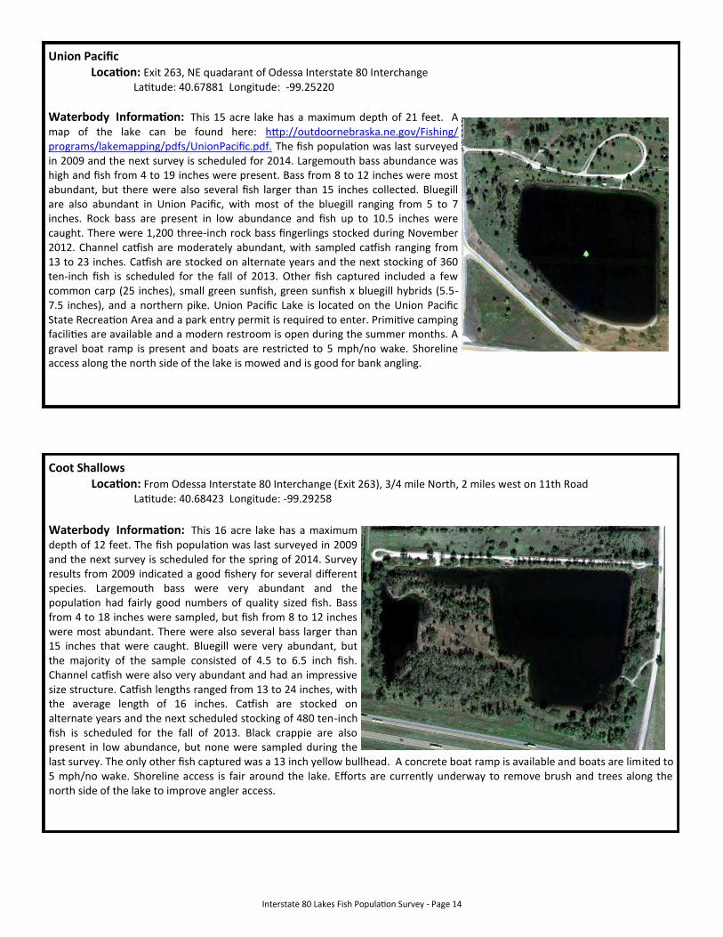
Union Pacific Location: Exit 263, NE quadarant of Odessa Interstate 80 Interchange Latitude: 40.67881 Longitude: -99.25220
Waterbody Information: This 15 acre lake has a maximum depth of 21 feet. A map of the lake can be found here: http://outdoornebraska.ne.gov/Fishing/programs/lakemapping/pdfs/UnionPacific.pdf. The fish population was last surveyed in 2009 and the next survey is scheduled for 2014. Largemouth bass abundance was high and fish from 4 to 19 inches were present. Bass from 8 to 12 inches were most abundant, but there were also several fish larger than 15 inches collected. Bluegill are also abundant in Union Pacific, with most of the bluegill ranging from 5 to 7 inches. Rock bass are present in low abundance and fish up to 10.5 inches were caught. There were 1,200 three-inch rock bass fingerlings stocked during November 2012. Channel catfish are moderately abundant, with sampled catfish ranging from 13 to 23 inches. Catfish are stocked on alternate years and the next stocking of 360 ten-inch fish is scheduled for the fall of 2013. Other fish captured included a few common carp (25 inches), small green sunfish, green sunfish x bluegill hybrids (5.5-7.5 inches), and a northern pike. Union Pacific Lake is located on the Union Pacific State Recreation Area and a park entry permit is required to enter. Primitive camping facilities are available and a modern restroom is open during the summer months. A gravel boat ramp is present and boats are restricted to 5 mph/no wake. Shoreline access along the north side of the lake is mowed and is good for bank angling.
Coot Shallows Location: From Odessa Interstate 80 Interchange (Exit 263), 3/4 mile North, 2 miles west on 11th Road Latitude: 40.68423 Longitude: -99.29258
Waterbody Information: This 16 acre lake has a maximum depth of 12 feet. The fish population was last surveyed in 2009 and the next survey is scheduled for the spring of 2014. Survey results from 2009 indicated a good fishery for several different species. Largemouth bass were very abundant and the population had fairly good numbers of quality sized fish. Bass from 4 to 18 inches were sampled, but fish from 8 to 12 inches were most abundant. There were also several bass larger than 15 inches that were caught. Bluegill were very abundant, but the majority of the sample consisted of 4.5 to 6.5 inch fish. Channel catfish were also very abundant and had an impressive size structure. Catfish lengths ranged from 13 to 24 inches, with the average length of 16 inches. Catfish are stocked on alternate years and the next scheduled stocking of 480 ten-inch fish is scheduled for the fall of 2013. Black crappie are also present in low abundance, but none were sampled during the last survey. The only other fish captured was a 13 inch yellow bullhead. A concrete boat ramp is available and boats are limited to 5 mph/no wake. Shoreline access is fair around the lake. Efforts are currently underway to remove brush and trees along the north side of the lake to improve angler access.
Interstate 80 Lakes Fish Population Survey - Page 15
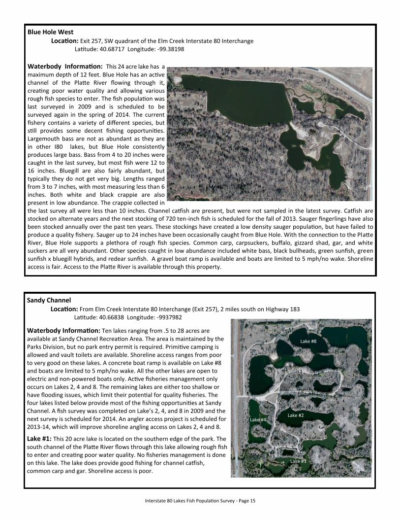
Blue Hole West Location: Exit 257, SW quadrant of the Elm Creek Interstate 80 Interchange Latitude: 40.68717 Longitude: -99.38198
Waterbody Information: This 24 acre lake has a maximum depth of 12 feet. Blue Hole has an active channel of the Platte River flowing through it, creating poor water quality and allowing various rough fish species to enter. The fish population was last surveyed in 2009 and is scheduled to be surveyed again in the spring of 2014. The current fishery contains a variety of different species, but still provides some decent fishing opportunities. Largemouth bass are not as abundant as they are in other I80 lakes, but Blue Hole consistently produces large bass. Bass from 4 to 20 inches were caught in the last survey, but most fish were 12 to 16 inches. Bluegill are also fairly abundant, but typically they do not get very big. Lengths ranged from 3 to 7 inches, with most measuring less than 6 inches. Both white and black crappie are also present in low abundance. The crappie collected in the last survey all were less than 10 inches. Channel catfish are present, but were not sampled in the latest survey. Catfish are stocked on alternate years and the next stocking of 720 ten-inch fish is scheduled for the fall of 2013. Sauger fingerlings have also been stocked annually over the past ten years. These stockings have created a low density sauger population, but have failed to produce a quality fishery. Sauger up to 24 inches have been occasionally caught from Blue Hole. With the connection to the Platte River, Blue Hole supports a plethora of rough fish species. Common carp, carpsuckers, buffalo, gizzard shad, gar, and white suckers are all very abundant. Other species caught in low abundance included white bass, black bullheads, green sunfish, green sunfish x bluegill hybrids, and redear sunfish. A gravel boat ramp is available and boats are limited to 5 mph/no wake. Shoreline access is fair. Access to the Platte River is available through this property.
Sandy Channel Location: From Elm Creek Interstate 80 Interchange (Exit 257), 2 miles south on Highway 183 Latitude: 40.66838 Longitude: -9937982
Waterbody Information: Ten lakes ranging from .5 to 28 acres are available at Sandy Channel Recreation Area. The area is maintained by the Parks Division, but no park entry permit is required. Primitive camping is allowed and vault toilets are available. Shoreline access ranges from poor to very good on these lakes. A concrete boat ramp is available on Lake #8 and boats are limited to 5 mph/no wake. All the other lakes are open to electric and non-powered boats only. Active fisheries management only occurs on Lakes 2, 4 and 8. The remaining lakes are either too shallow or have flooding issues, which limit their potential for quality fisheries. The four lakes listed below provide most of the fishing opportunities at Sandy Channel. A fish survey was completed on Lake’s 2, 4, and 8 in 2009 and the next survey is scheduled for 2014. An angler access project is scheduled for 2013-14, which will improve shoreline angling access on Lakes 2, 4 and 8.
Lake #1: This 20 acre lake is located on the southern edge of the park. The south channel of the Platte River flows through this lake allowing rough fish to enter and creating poor water quality. No fisheries management is done on this lake. The lake does provide good fishing for channel catfish, common carp and gar. Shoreline access is poor.
Lake #2 Lake #4
Lake #1
Lake #8
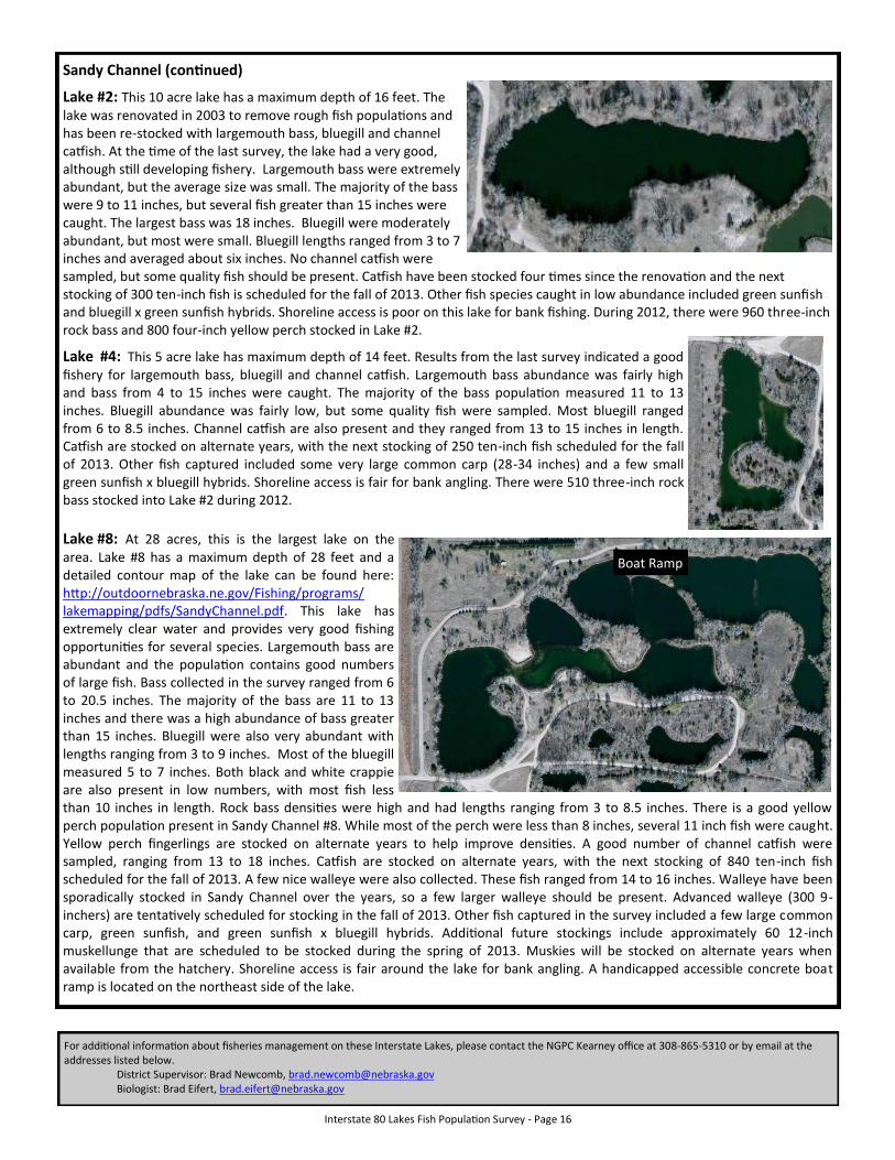
Interstate 80 Lakes Fish Population Survey - Page 16
Sandy Channel (continued)
Lake #2: This 10 acre lake has a maximum depth of 16 feet. The lake was renovated in 2003 to remove rough fish populations and has been re-stocked with largemouth bass, bluegill and channel catfish. At the time of the last survey, the lake had a very good, although still developing fishery. Largemouth bass were extremely abundant, but the average size was small. The majority of the bass were 9 to 11 inches, but several fish greater than 15 inches were caught. The largest bass was 18 inches. Bluegill were moderately abundant, but most were small. Bluegill lengths ranged from 3 to 7 inches and averaged about six inches. No channel catfish were sampled, but some quality fish should be present. Catfish have been stocked four times since the renovation and the next stocking of 300 ten-inch fish is scheduled for the fall of 2013. Other fish species caught in low abundance included green sunfish and bluegill x green sunfish hybrids. Shoreline access is poor on this lake for bank fishing. During 2012, there were 960 three-inch rock bass and 800 four-inch yellow perch stocked in Lake #2.
Lake #4: This 5 acre lake has maximum depth of 14 feet. Results from the last survey indicated a good fishery for largemouth bass, bluegill and channel catfish. Largemouth bass abundance was fairly high and bass from 4 to 15 inches were caught. The majority of the bass population measured 11 to 13 inches. Bluegill abundance was fairly low, but some quality fish were sampled. Most bluegill ranged from 6 to 8.5 inches. Channel catfish are also present and they ranged from 13 to 15 inches in length. Catfish are stocked on alternate years, with the next stocking of 250 ten-inch fish scheduled for the fall of 2013. Other fish captured included some very large common carp (28-34 inches) and a few small green sunfish x bluegill hybrids. Shoreline access is fair for bank angling. There were 510 three-inch rock bass stocked into Lake #2 during 2012. Lake #8: At 28 acres, this is the largest lake on the area. Lake #8 has a maximum depth of 28 feet and a detailed contour map of the lake can be found here: http://outdoornebraska.ne.gov/Fishing/programs/lakemapping/pdfs/SandyChannel.pdf. This lake has extremely clear water and provides very good fishing opportunities for several species. Largemouth bass are abundant and the population contains good numbers of large fish. Bass collected in the survey ranged from 6 to 20.5 inches. The majority of the bass are 11 to 13 inches and there was a high abundance of bass greater than 15 inches. Bluegill were also very abundant with lengths ranging from 3 to 9 inches. Most of the bluegill measured 5 to 7 inches. Both black and white crappie are also present in low numbers, with most fish less than 10 inches in length. Rock bass densities were high and had lengths ranging from 3 to 8.5 inches. There is a good yellow perch population present in Sandy Channel #8. While most of the perch were less than 8 inches, several 11 inch fish were caught. Yellow perch fingerlings are stocked on alternate years to help improve densities. A good number of channel catfish were sampled, ranging from 13 to 18 inches. Catfish are stocked on alternate years, with the next stocking of 840 ten-inch fish scheduled for the fall of 2013. A few nice walleye were also collected. These fish ranged from 14 to 16 inches. Walleye have been sporadically stocked in Sandy Channel over the years, so a few larger walleye should be present. Advanced walleye (300 9-inchers) are tentatively scheduled for stocking in the fall of 2013. Other fish captured in the survey included a few large common carp, green sunfish, and green sunfish x bluegill hybrids. Additional future stockings include approximately 60 12-inch muskellunge that are scheduled to be stocked during the spring of 2013. Muskies will be stocked on alternate years when available from the hatchery. Shoreline access is fair around the lake for bank angling. A handicapped accessible concrete boat ramp is located on the northeast side of the lake.
Boat Ramp
For additional information about fisheries management on these Interstate Lakes, please contact the NGPC Kearney office at 308-865-5310 or by email at the addresses listed below. District Supervisor: Brad Newcomb, [email protected] Biologist: Brad Eifert, [email protected]