Landscapes and soils of the Katanning district
27
Landscapes and soils of the Katanning district This is a sandy landscape with a deep sandy duplex soil where you have stopped. Note the wandoo upslope to the west, and the saprock dam. Also notice the granite outcrops to your right on the southern slope of the flat. Figure 49 Stop 7 24.8 km—Broomehill (public toilet available). Turn south, and as you drive, note the subdued mainly duplex soil landscape that is typical of the north-south area that runs from just west of Katanning to Tambellup, with wandoo/flat-topped yate/brown mallet woodland. Numerous east-west dolerite dykes of the Gnowangerup dyke swarm (Mulligan S, (1999)) cross the road, and can easily be seen by the red soils supporting brown mallet on the road verge. Turn left on the Gnowangerup Road. As you drive down this road, note the vegetation change from wandoo (grey sandy duplex on rises formed over pallid zone), to flat-topped yate (often poorly drained soil on a low slope formed over mixed igneous rock and sap rock), to York gum (more dissected better drained areas, often with brown duplex soils formed over gneiss and dolerite). 37.6 km Turn left on to Fletcher Road. Figure 50 shows a more detailed view of the transition from the Upper Pallinup system to the Tieline system upland plain that straddles the Jarrahwood Axis. Note the vegetation change as you cross the waterway. York gum vegetation changes to wandoo- rock sheoak (deep and sandy duplex soils), then to flat-topped yate on the gently sloping land down to the waterway around the corner. Continue to the left up the slope (Upper Pallinup subsystem 2) and note the vegetation changes and associated soils. 81
Transcript of Landscapes and soils of the Katanning district

Landscapes and soils of the Katanning district
This is a sandy landscape with a deep sandy duplex soil where you have stopped. Note the wandoo upslope to the west, and the saprock dam. Also notice the granite outcrops to your right on the southern slope of the flat.
Figure 49 Stop 7
24.8 km—Broomehill (public toilet available). Turn south, and as you drive, note the subdued mainly duplex soil landscape that is typical of the north-south area that runs from just west of Katanning to Tambellup, with wandoo/flat-topped yate/brown mallet woodland. Numerous east-west dolerite dykes of the Gnowangerup dyke swarm (Mulligan S, (1999)) cross the road, and can easily be seen by the red soils supporting brown mallet on the road verge.
Turn left on the Gnowangerup Road. As you drive down this road, note the vegetation change from wandoo (grey sandy duplex on rises formed over pallid zone), to flat-topped yate (often poorly drained soil on a low slope formed over mixed igneous rock and sap rock), to York gum (more dissected better drained areas, often with brown duplex soils formed over gneiss and dolerite).
37.6 km Turn left on to Fletcher Road.
Figure 50 shows a more detailed view of the transition from the Upper Pallinup system to the Tieline system upland plain that straddles the Jarrahwood Axis.
Note the vegetation change as you cross the waterway. York gum vegetation changes to wandoo- rock sheoak (deep and sandy duplex soils), then to flat-topped yate on the gently sloping land down to the waterway around the corner. Continue to the left up the slope (Upper Pallinup subsystem 2) and note the vegetation changes and associated soils.
81

February 2011
Figure 50 Map showing the transition from the Upper Pallinup system to the Tieline system.
40.6 km—Stop 8 575755/6253554. This is the Jarrahwood axis again, and marks the start of the Tieline soil landscape system, that is often underlain by pallid zone. As the landscape has little relief, sandy rises, duplexes with poorly structured pallid subsoils are common, and frost and waterlogging are limiting factors for crop and pasture production.
Investigate this site using a site investigation sheet and compare your results with the completed sheet at the end of this chapter.
Figure 51 Stop 8
When you turn left after leaving Stop 8 note that there is a narrow band of brown soil in the paddock on the left. There is no change to the wandoo vegetation and the band is mainly a hard setting brownish lateritic soil except for one small patch of doleritic loamy duplex
Upper Pallinup 3 Soils from igneous rock
Upper Pallinup 2 Dissected laterite uplands
Tieline 2. Mid, upper slopes and crests
Dolerite dyke
8
10 9
Fletcher Road Gnowangerup Road
82
Landscapes and soils of the Katanning district
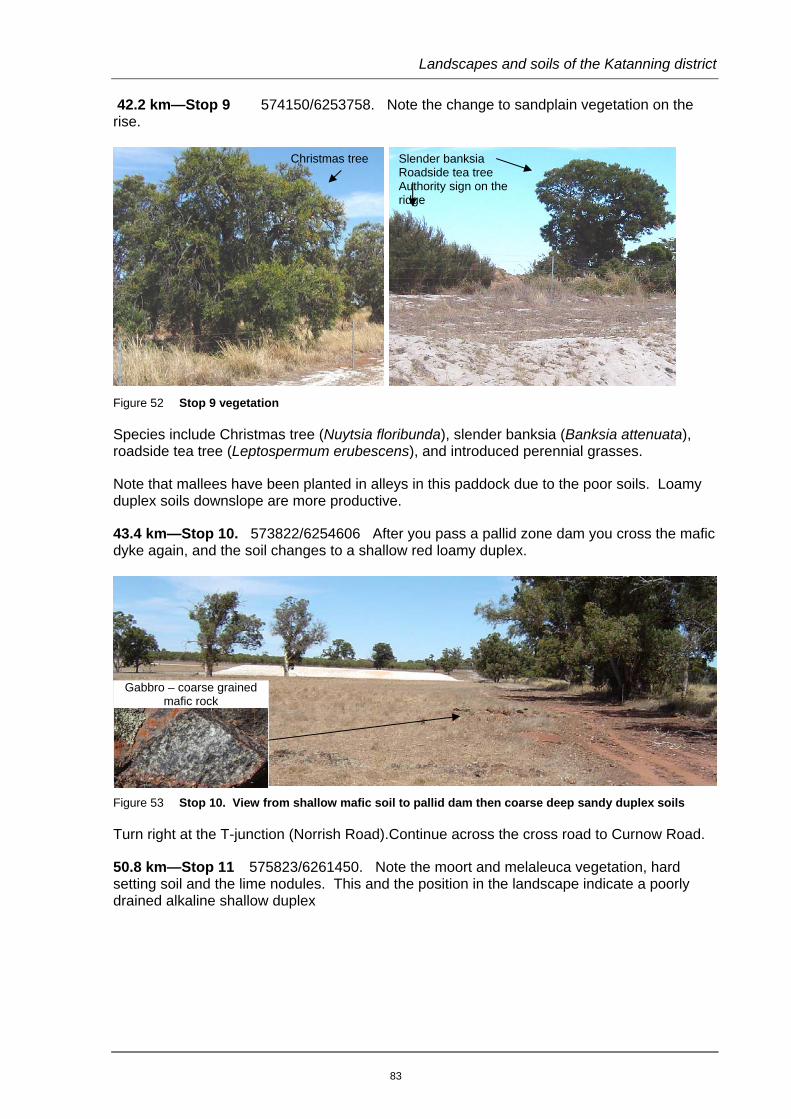
42.2 km—Stop 9 574150/6253758. Note the change to sandplain vegetation on the rise.
Figure 52 Stop 9 vegetation
Species include Christmas tree (Nuytsia floribunda), slender banksia (Banksia attenuata), roadside tea tree (Leptospermum erubescens), and introduced perennial grasses.
Note that mallees have been planted in alleys in this paddock due to the poor soils. Loamy duplex soils downslope are more productive.
43.4 km—Stop 10. 573822/6254606 After you pass a pallid zone dam you cross the mafic dyke again, and the soil changes to a shallow red loamy duplex.
Figure 53 Stop 10. View from shallow mafic soil to pallid dam then coarse deep sandy duplex soils
Turn right at the T-junction (Norrish Road).Continue across the cross road to Curnow Road.
50.8 km—Stop 11 575823/6261450. Note the moort and melaleuca vegetation, hard setting soil and the lime nodules. This and the position in the landscape indicate a poorly drained alkaline shallow duplex
Gabbro – coarse grained mafic rock
Slender banksia Roadside tea tree Authority sign on the ridge
Christmas tree
83

February 2011
Figure 54 Stop 11 Moort-melaleuca flat
Turn left on to Scotchmans Road: note the change to a more undulating landscape as you enter the East Katanning system. Turn right on Tieline Road then veer right up Langaweira Road then left on to Belmont Road.
67.8 km—Stop 11 566562/6265739. Enter the track to the right near the top of the ridge, drive until you reach the tree lined fence line on the right hand side. Note the large mafic laterite ridge and red loamy soils formed from mottled zone and underlying mafic rock, of a north-south trending dyke.
At the stop, you can see the red mottled subsoil clay, and the blue mallet (E. gardneri) vegetation with wandoo. Many people could confuse blue mallet (dull blue green leaves) with brown mallet (shiny green leaves), particularly here where the mallet stem is quite brown. Blue mallet is more specific in its distribution, occurring on mafic gravelly hill tops, where it occurs with brown mallet and/or silver mallet.
Return to Belmont Road and turn left towards Katanning. As you cross the ridge the soil changes dramatically to a deep grey sandy duplex that probably has been influenced by aeolian sand blown up from the major valley system that you are entering.
Figure 55 Stop 12. Wandoo in foreground with blue mallet upslope
87 km Arrive back at Katanning district office.
Planted swamp mallet E. spathulata.
Moort E. platypus Large melaleuca
Blue mallet
84

Landscapes and soils of the Katanning district
Completed site investigation sheets
Stop 2
Indicator vegetation Mainly York gum and jam. Occasional flooded gum downslope.
Where are you in the landscape At the base of a low spur in an almost level area with a slope to the south. It is difficult to determine landscape type here apart from soil colour and remnant vegetation.
Surface clues Mafic outcrop and stones on the soil surface.
Other clues
Your conclusion re the Landscape and soil(s)
Rocky red brown loamy soil. The soil is a brown loamy earth with a brown sandy clay loam pH5.6 over a brown sandy clay pH5.8 (calcium chloride pH).
Stop 3
Indicator vegetation
Manna wattle with some stinkwood (Jacksonia sternbergiana) that is often an indicator of sandy soils. Wandoo to the west.
Note the difference between manna wattle here and jam upslope.
Where are you in the landscape Lower slope near the break of slope. Surface clues
Other clues
Gritty sand surface and stones visible on the soil surface upslope indicate a colluvial soil with a granitic or quartz soil upslope.
Your conclusion re the Landscape and soil(s)
An auger hole at this stop showed a sandy earth soil that doesn’t fit into any common soil category, but is associated with grey deep sandy duplexes further west. 0–10 cm Grey brown loamy sand pH 4.5. 10–25 cm grey sand with occasional gravel stones pH 4.4. 25 cm pale hard setting sandy loam pH4.6. Note that this soil requires liming. Further downslope the sand becomes deeper to grey deep sand (note the stinkwood shrubs).
Stop 6
Indicator vegetation
Wandoo, manna wattle.
Where are you in the landscape Ridge. The smooth landscape indicates a granitic area.
Surface clues Quartz, pallid zone, hard setting surface.
Other clues
Pallid zone dam downslope.
Your conclusion re the
Landscape and soil(s)
This is a sandy granite area where erosion has stripped the upper layers off a laterite to the pallid zone. A hard setting grey shallow sandy duplex (Indinup1 series) has formed from pallid clay.
85

February 2011
Stop 8
Indicator vegetation
Mallee (E. thamnoides, a mallee equivalent of brown mallet often found on shallow duplex soils), low melaleuca and wandoo. This is a good example of mallee with sparse understorey found on poorly structured clays.
Where are you in the landscape Slight rise on an upland plain.
Surface clues Pallid zone fragments, very hard setting surface.
Other clues
.
Your conclusion re the
Landscape and soil(s)
Wandoo-mallee -mallet hard-setting grey duplex.
This is a hard-setting acidic shallow loamy duplex that is one of a group of soils commonly called grey clay. Alkaline versions occur in the broad valleys.
86
Landscapes and soils of the Katanning district
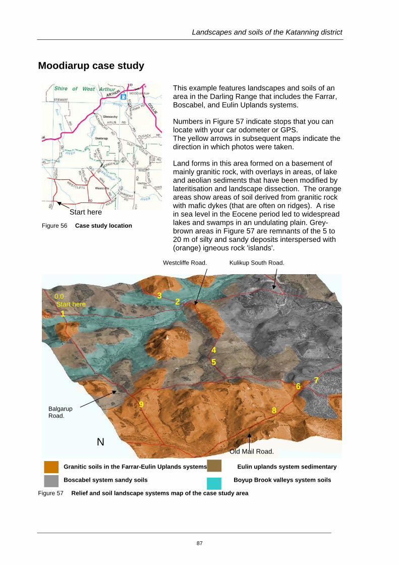
Moodiarup case study
This example features landscapes and soils of an area in the Darling Range that includes the Farrar, Boscabel, and Eulin Uplands systems.
Numbers in Figure 57 indicate stops that you can locate with your car odometer or GPS. The yellow arrows in subsequent maps indicate the direction in which photos were taken.
Land forms in this area formed on a basement of mainly granitic rock, with overlays in areas, of lake and aeolian sediments that have been modified by lateritisation and landscape dissection. The orange areas show areas of soil derived from granitic rock with mafic dykes (that are often on ridges). A rise in sea level in the Eocene period led to widespread lakes and swamps in an undulating plain. Grey-brown areas in Figure 57 are remnants of the 5 to 20 m of silty and sandy deposits interspersed with (orange) igneous rock 'islands'.
Granitic soils in the Farrar-Eulin Uplands systems Eulin uplands system sedimentary
Boscabel system sandy soils Boyup Brook valleys system soils
Figure 57 Relief and soil landscape systems map of the case study area
Figure 56 Case study location
Start here
Westcliffe Road. Kulikup South Road.
0.0 Start here
3 2
1
4
7 6
5
Balgarup Road.
9 8
N Old Mail Road.
87
February 2011
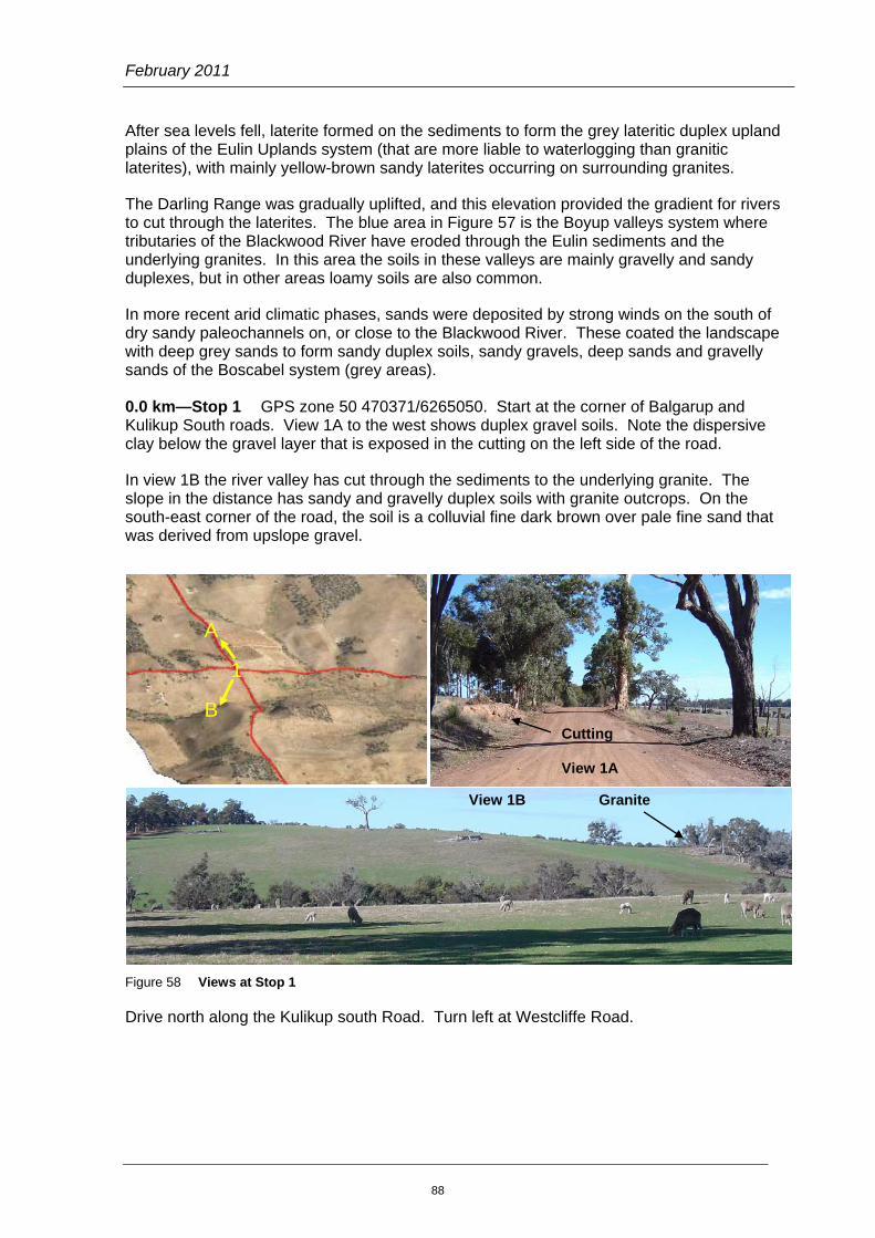
After sea levels fell, laterite formed on the sediments to form the grey lateritic duplex upland plains of the Eulin Uplands system (that are more liable to waterlogging than granitic laterites), with mainly yellow-brown sandy laterites occurring on surrounding granites.
The Darling Range was gradually uplifted, and this elevation provided the gradient for rivers to cut through the laterites. The blue area in Figure 57 is the Boyup valleys system where tributaries of the Blackwood River have eroded through the Eulin sediments and the underlying granites. In this area the soils in these valleys are mainly gravelly and sandy duplexes, but in other areas loamy soils are also common.
In more recent arid climatic phases, sands were deposited by strong winds on the south of dry sandy paleochannels on, or close to the Blackwood River. These coated the landscape with deep grey sands to form sandy duplex soils, sandy gravels, deep sands and gravelly sands of the Boscabel system (grey areas).
0.0 km—Stop 1 GPS zone 50 470371/6265050. Start at the corner of Balgarup and Kulikup South roads. View 1A to the west shows duplex gravel soils. Note the dispersive clay below the gravel layer that is exposed in the cutting on the left side of the road.
In view 1B the river valley has cut through the sediments to the underlying granite. The slope in the distance has sandy and gravelly duplex soils with granite outcrops. On the south-east corner of the road, the soil is a colluvial fine dark brown over pale fine sand that was derived from upslope gravel.
Figure 58 Views at Stop 1
Drive north along the Kulikup south Road. Turn left at Westcliffe Road.
A
B
1
Cutting View 1A
View 1B Granite
88
Landscapes and soils of the Katanning district
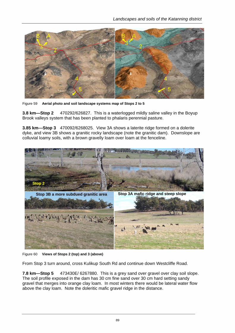
Figure 59 Aerial photo and soil landscape systems map of Stops 2 to 5
3.8 km—Stop 2 470292/626827. This is a waterlogged mildly saline valley in the Boyup Brook valleys system that has been planted to phalaris perennial pasture.
3.85 km—Stop 3 470092/6268025. View 3A shows a laterite ridge formed on a dolerite dyke, and view 3B shows a granitic rocky landscape (note the granitic dam). Downslope are colluvial loamy soils, with a brown gravelly loam over loam at the fenceline.
Figure 60 Views of Stops 2 (top) and 3 (above)
From Stop 3 turn around, cross Kulikup South Rd and continue down Westcliffe Road.
7.8 km—Stop 5 473430E/ 6267880. This is a grey sand over gravel over clay soil slope. The soil profile exposed in the dam has 30 cm fine sand over 30 cm hard setting sandy gravel that merges into orange clay loam. In most winters there would be lateral water flow above the clay loam. Note the doleritic mafic gravel ridge in the distance.
Stop 2
Stop 3A mafic ridge and steep slope Stop 3B a more subdued granitic area
BB 3
A A
2 2 3
4 4
5 5
89
February 2011
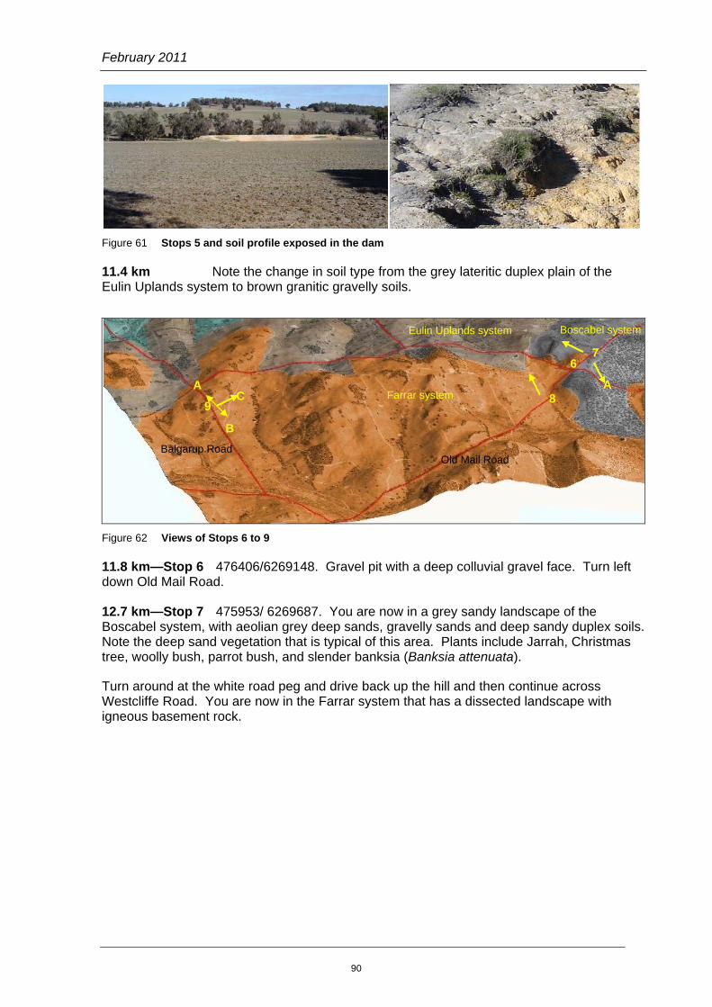
Figure 61 Stops 5 and soil profile exposed in the dam
11.4 km Note the change in soil type from the grey lateritic duplex plain of the Eulin Uplands system to brown granitic gravelly soils.
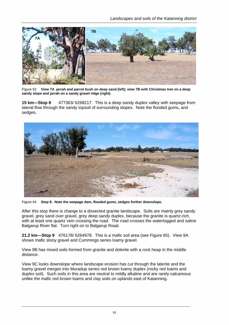
Figure 62 Views of Stops 6 to 9
11.8 km—Stop 6 476406/6269148. Gravel pit with a deep colluvial gravel face. Turn left down Old Mail Road.
12.7 km—Stop 7 475953/ 6269687. You are now in a grey sandy landscape of the Boscabel system, with aeolian grey deep sands, gravelly sands and deep sandy duplex soils. Note the deep sand vegetation that is typical of this area. Plants include Jarrah, Christmas tree, woolly bush, parrot bush, and slender banksia (Banksia attenuata).
Turn around at the white road peg and drive back up the hill and then continue across Westcliffe Road. You are now in the Farrar system that has a dissected landscape with igneous basement rock.
7
9 8
6
C A A
B
Eulin Uplands system Boscabel system
Farrar system
Old Mail Road Balgarup Road
90
Landscapes and soils of the Katanning district
Figure 63 View 7A jarrah and parrot bush on deep sand (left); view 7B with Christmas tree on a deep sandy slope and jarrah on a sandy gravel ridge (right).
15 km—Stop 8 477363/ 6268217. This is a deep sandy duplex valley with seepage from lateral flow through the sandy topsoil of surrounding slopes. Note the flooded gums, and sedges.
Figure 64 Stop 8. Note the seepage dam, flooded gums, sedges further downslope.
After this stop there is change to a dissected granite landscape. Soils are mainly grey sandy gravel, grey sand over gravel, grey deep sandy duplex, because the granite is quartz-rich, with at least one quartz vein crossing the road. The road crosses the waterlogged and saline Balgarup River flat. Turn right on to Balgarup Road.
21.2 km—Stop 9 476178/ 6264978. This is a mafic soil area (see Figure 65). View 9A shows mafic stony gravel and Cummings series loamy gravel.
View 9B has mixed soils formed from granite and dolerite with a rock heap in the middle distance.
View 9C looks downslope where landscape erosion has cut through the laterite and the loamy gravel merges into Muradup series red brown loamy duplex (rocky red loams and duplex soil). Such soils in this area are neutral to mildly alkaline and are rarely calcareous unlike the mafic red brown loams and clay soils on uplands east of Katanning.
7B
7A
91

February 2011
Figure 65 Stop 9 views
27.4 km Return to Stop 1.
9C
9B 9A
92
Landscapes and soils of the Katanning district
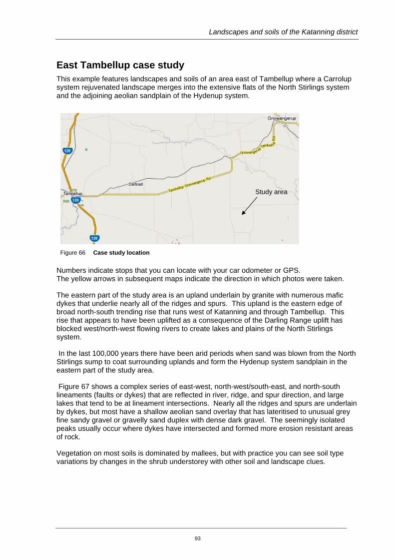
East Tambellup case study This example features landscapes and soils of an area east of Tambellup where a Carrolup system rejuvenated landscape merges into the extensive flats of the North Stirlings system and the adjoining aeolian sandplain of the Hydenup system.
Figure 66 Case study location
Numbers indicate stops that you can locate with your car odometer or GPS. The yellow arrows in subsequent maps indicate the direction in which photos were taken.
The eastern part of the study area is an upland underlain by granite with numerous mafic dykes that underlie nearly all of the ridges and spurs. This upland is the eastern edge of broad north-south trending rise that runs west of Katanning and through Tambellup. This rise that appears to have been uplifted as a consequence of the Darling Range uplift has blocked west/north-west flowing rivers to create lakes and plains of the North Stirlings system.
In the last 100,000 years there have been arid periods when sand was blown from the North Stirlings sump to coat surrounding uplands and form the Hydenup system sandplain in the eastern part of the study area.
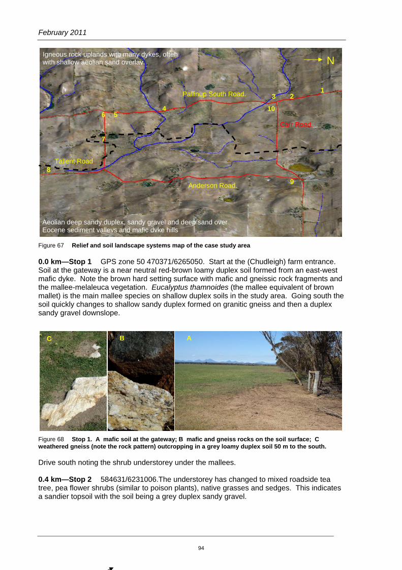
Figure 67 shows a complex series of east-west, north-west/south-east, and north-south lineaments (faults or dykes) that are reflected in river, ridge, and spur direction, and large lakes that tend to be at lineament intersections. Nearly all the ridges and spurs are underlain by dykes, but most have a shallow aeolian sand overlay that has lateritised to unusual grey fine sandy gravel or gravelly sand duplex with dense dark gravel. The seemingly isolated peaks usually occur where dykes have intersected and formed more erosion resistant areas of rock.
Vegetation on most soils is dominated by mallees, but with practice you can see soil type variations by changes in the shrub understorey with other soil and landscape clues.
Study area
93
February 2011
Figure 67 Relief and soil landscape systems map of the case study area
0.0 km—Stop 1 GPS zone 50 470371/6265050. Start at the (Chudleigh) farm entrance. Soil at the gateway is a near neutral red-brown loamy duplex soil formed from an east-west mafic dyke. Note the brown hard setting surface with mafic and gneissic rock fragments and the mallee-melaleuca vegetation. Eucalyptus thamnoides (the mallee equivalent of brown mallet) is the main mallee species on shallow duplex soils in the study area. Going south the soil quickly changes to shallow sandy duplex formed on granitic gneiss and then a duplex sandy gravel downslope.
Figure 68 Stop 1. A mafic soil at the gateway; B mafic and gneiss rocks on the soil surface; C weathered gneiss (note the rock pattern) outcropping in a grey loamy duplex soil 50 m to the south.
Drive south noting the shrub understorey under the mallees.
0.4 km—Stop 2 584631/6231006.The understorey has changed to mixed roadside tea tree, pea flower shrubs (similar to poison plants), native grasses and sedges. This indicates a sandier topsoil with the soil being a grey duplex sandy gravel.
3 2 1
4
7
6 5
9
8
Carr Road.
N
Pallinup South Road.
Tallent Road.
Anderson Road.
Aeolian deep sandy duplex, sandy gravel and deep sand over Eocene sediment valleys and mafic dyke hills
Igneous rock uplands with many dykes, often with shallow aeolian sand overlay
10
A C B
94
Landscapes and soils of the Katanning district
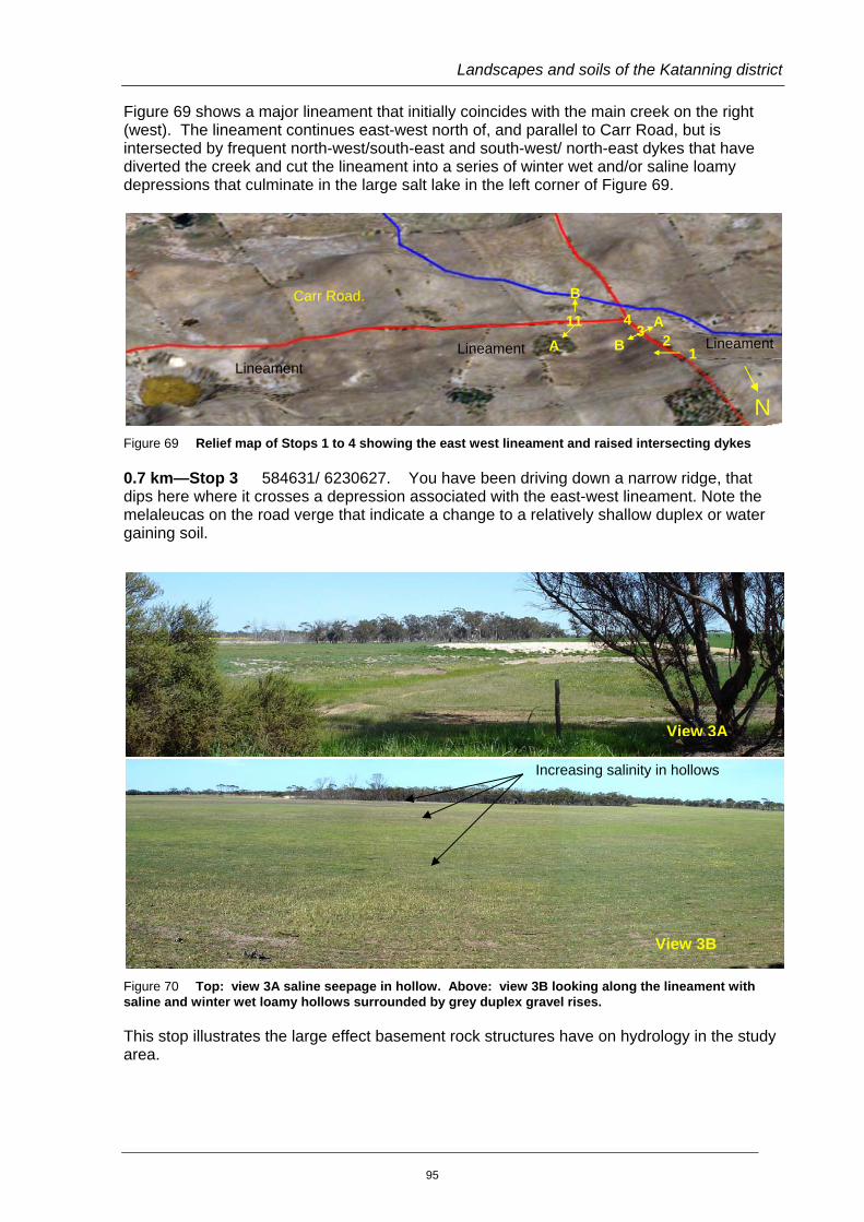
Figure 69 shows a major lineament that initially coincides with the main creek on the right (west). The lineament continues east-west north of, and parallel to Carr Road, but is intersected by frequent north-west/south-east and south-west/ north-east dykes that have diverted the creek and cut the lineament into a series of winter wet and/or saline loamy depressions that culminate in the large salt lake in the left corner of Figure 69.
Figure 69 Relief map of Stops 1 to 4 showing the east west lineament and raised intersecting dykes
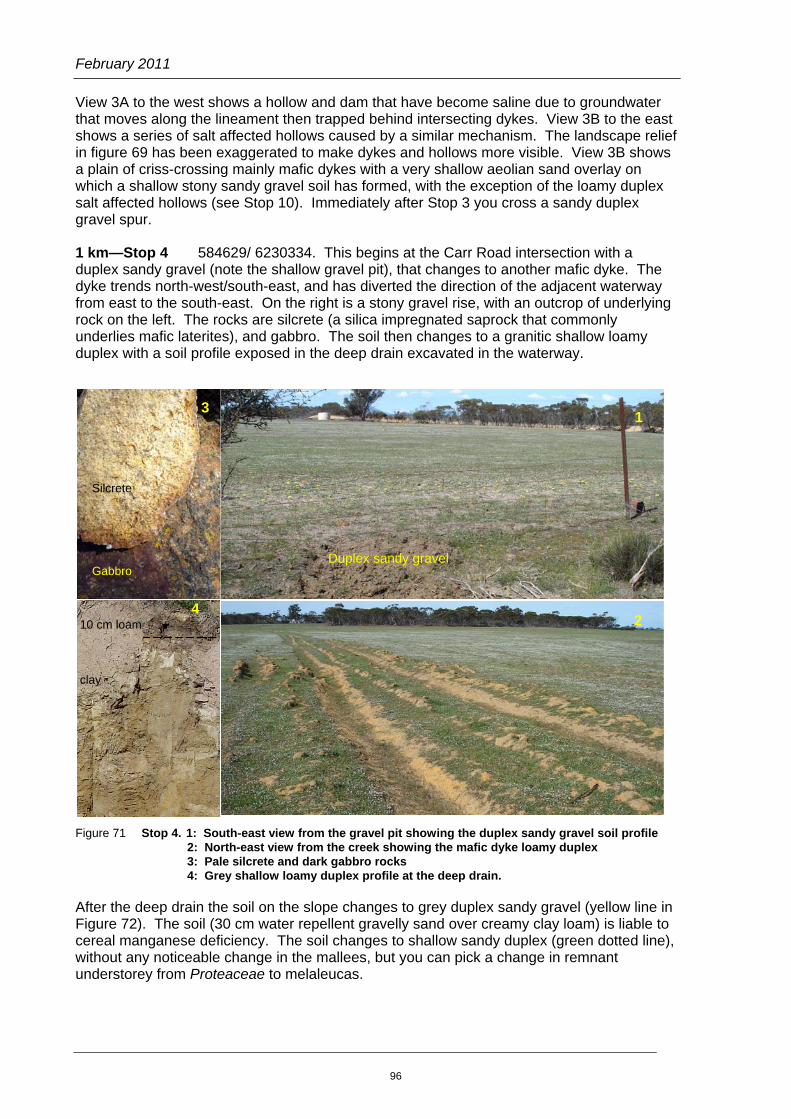
0.7 km—Stop 3 584631/ 6230627. You have been driving down a narrow ridge, that dips here where it crosses a depression associated with the east-west lineament. Note the melaleucas on the road verge that indicate a change to a relatively shallow duplex or water gaining soil.
Figure 70 Top: view 3A saline seepage in hollow. Above: view 3B looking along the lineament with saline and winter wet loamy hollows surrounded by grey duplex gravel rises.
This stop illustrates the large effect basement rock structures have on hydrology in the study area.
Increasing salinity in hollows
View 3A
View 3B
N
112
1
3
4
Lineament
Lineament
Lineament
B
A
A
BCarr Road.
95
February 2011
View 3A to the west shows a hollow and dam that have become saline due to groundwater that moves along the lineament then trapped behind intersecting dykes. View 3B to the east shows a series of salt affected hollows caused by a similar mechanism. The landscape relief in figure 69 has been exaggerated to make dykes and hollows more visible. View 3B shows a plain of criss-crossing mainly mafic dykes with a very shallow aeolian sand overlay on which a shallow stony sandy gravel soil has formed, with the exception of the loamy duplex salt affected hollows (see Stop 10). Immediately after Stop 3 you cross a sandy duplex gravel spur.
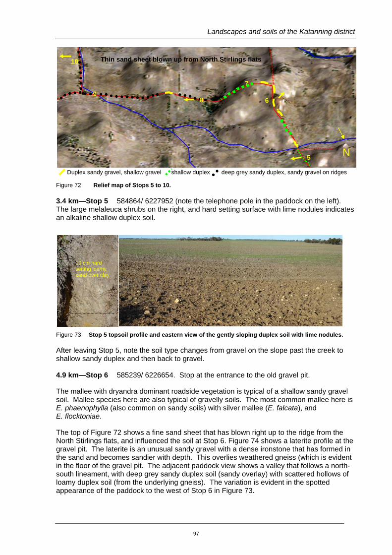
1 km—Stop 4 584629/ 6230334. This begins at the Carr Road intersection with a duplex sandy gravel (note the shallow gravel pit), that changes to another mafic dyke. The dyke trends north-west/south-east, and has diverted the direction of the adjacent waterway from east to the south-east. On the right is a stony gravel rise, with an outcrop of underlying rock on the left. The rocks are silcrete (a silica impregnated saprock that commonly underlies mafic laterites), and gabbro. The soil then changes to a granitic shallow loamy duplex with a soil profile exposed in the deep drain excavated in the waterway.
Figure 71 Stop 4. 1: South-east view from the gravel pit showing the duplex sandy gravel soil profile
2: North-east view from the creek showing the mafic dyke loamy duplex 3: Pale silcrete and dark gabbro rocks 4: Grey shallow loamy duplex profile at the deep drain.
After the deep drain the soil on the slope changes to grey duplex sandy gravel (yellow line in Figure 72). The soil (30 cm water repellent gravelly sand over creamy clay loam) is liable to cereal manganese deficiency. The soil changes to shallow sandy duplex (green dotted line), without any noticeable change in the mallees, but you can pick a change in remnant understorey from Proteaceae to melaleucas.
10 cm loam clay
1
4
2
Silcrete Gabbro
3
Duplex sandy gravel
96
Landscapes and soils of the Katanning district
Duplex sandy gravel, shallow gravel shallow duplex deep grey sandy duplex, sandy gravel on ridges
Figure 72 Relief map of Stops 5 to 10.
3.4 km—Stop 5 584864/ 6227952 (note the telephone pole in the paddock on the left). The large melaleuca shrubs on the right, and hard setting surface with lime nodules indicates an alkaline shallow duplex soil.
Figure 73 Stop 5 topsoil profile and eastern view of the gently sloping duplex soil with lime nodules.
After leaving Stop 5, note the soil type changes from gravel on the slope past the creek to shallow sandy duplex and then back to gravel.
4.9 km—Stop 6 585239/ 6226654. Stop at the entrance to the old gravel pit.
The mallee with dryandra dominant roadside vegetation is typical of a shallow sandy gravel soil. Mallee species here are also typical of gravelly soils. The most common mallee here is E. phaenophylla (also common on sandy soils) with silver mallee (E. falcata), and E. flocktoniae.
The top of Figure 72 shows a fine sand sheet that has blown right up to the ridge from the North Stirlings flats, and influenced the soil at Stop 6. Figure 74 shows a laterite profile at the gravel pit. The laterite is an unusual sandy gravel with a dense ironstone that has formed in the sand and becomes sandier with depth. This overlies weathered gneiss (which is evident in the floor of the gravel pit. The adjacent paddock view shows a valley that follows a north-south lineament, with deep grey sandy duplex soil (sandy overlay) with scattered hollows of loamy duplex soil (from the underlying gneiss). The variation is evident in the spotted appearance of the paddock to the west of Stop 6 in Figure 73.
10 cm hard setting loamy sand over clay
N
7
5
10
Thin sand sheet blown up from North Stirlings flats
6
8
9
97

February 2011
Figure 74 Stop 6. Sandy gravel profile (top left); Top right: mallee-dryandra vegetation (top right); paddock view of a grey deep sandy duplex valley with scattered loamy duplex patches (above).
Turn left down Anderson Road.
5.1 km—Stop 7 GPS 585543/6226406. See Figure 75. The north-west/south-east trending mafic ridge crossing the road here has a red-brown loamy soil with moort and E. annulata roadside vegetation. Moort is more commonly associated with hard-setting grey clay, but E. annulata is often found on these soils further east.
Figure 75 Stop 7. Sandy gravel over clay on slope north of the road (left); thin grey sandy overlay with mafic subsoil exposed in a gully south of the road (right).
The scraped catchments for the dams on either side of the road show that the soil changes downhill to a shallow sandy gravel over clay. Banded clays from decomposed gneiss can be seen in catchment gullies.
98

Landscapes and soils of the Katanning district
5.5 km—Stop 8 586201/6226430. This is just past the swamp that marks a change to a valley with aeolian sand over Eocene sediment. The roadside vegetation has changed to sandplain mallee heath (E. uncinata with cabbage hakea, roadside tea tree, stinkwood, perennial grasses). The soil is a deep sandy duplex (40 to 60 cm fine pale to yellow sand over pale clay).
From this site you travel up a deep sand slope with mafic influence sandy gravel on the ridge and down to a deep drain in the course of the major waterway from the study area. The deep sandy duplex soil profile is exposed here.
Figure 76 Mallee sandplain heath at Stop 8 (left), deep sandy duplex soil profile in the drain (right).
7.3 km Turn right down Tallents Road. Note the vegetation changes to flat-topped yate with a bottlebrush understorey (winter-wet sandy duplex) then mallee sandplain heath on grey deep sandy duplex.
8.3 km—Stop 9 587768/6225394. Flat topped yate patch where the drain crosses the road. This gives a view of the extensive flats of the North Stirlings system. Further south the soil grades into shallow alkaline duplex with frequent saline areas. Return to Anderson Road and turn right.
For the next 6 km, you will travel through a sandy landscape. Soils are mainly deep sandy duplex, with sandy gravels on sand-covered mafic dyke rises and scattered areas of deep sand.
9.3 km—Stop 10 588378/6230660. This is a deep sand dune. Note the slender banksia and sandplain heath.
9.6 km Turn right at the T-junction and drive past the salt lake surrounded by flat-topped yate and York gum vegetation, with deep sand soils on your left.
11.4 km You are returning to slightly more undulating country with duplex sandy gravel soils on dyke rises and waterlogged and poorly drained hollows. As you drive note the isolated moort patch (mafic soil) on the left.
13.1 km—Stop 11 584922/6236357. This is typical of the almost flat lowland gravelly plain you have been driving through. This area is a part of the complex arrangement of mafic dykes and lineaments, and thin sand sheets that you saw at Stops 3 and 4. The mallee understorey is very variable containing grasses, dryandras (gravelly soil), cabbage hakea, and roadside tea tree (sandy soil) and melaleucas (this flat area may become waterlogged in wet years). The main soils are duplex sandy gravel and shallow gravel, with loamy duplex waterlogged depressions.
99

February 2011
Figure 77 Stop 11 views. Roadside mallee heath (top); north view of the duplex sandy gravel plain of the east west trending lineament with saline loamy hollows (11A); north view of the duplex sandy gravel plain with shallow gravel (mafic dyke) rises (11B).
Return to South Pallinup Road. End.
11A
11B
100

Landscapes and soils of the Katanning district
REFERENCES Agriculture Western Australia Bulletin. 4343 (1998). Soilguide. A handbook for understanding and managing agricultural soils. (ed G. Moore),.
Beard, J.S. (1979). The Vegetation of the Albany/Mt Barker Areas, Western Australia. Explanatory memoir – 1:250,000 map series. Vegemap Publications, Perth, Australia.
Beard, J.S. (1980). The Vegetation of the Dumbleyung Area, Western Australia. Explanatory memoir – 1:250,000 map series. Vegemap Publications, Perth, Australia.
Beard, J.S. (1980). The Plant Life of Western Australia. Kangaroo Press.
Beard, J.S. (1980b). The Vegetation of the Corrigin Area, Western Australia. Explanatory memoir – 1:250,000 map series. Vegemap Publications, Perth, Australia.
Beard, J.S. (1998). Evolution of the river systems of the south-west drainage division, Western Australia. Journal of the Royal Society of Western Australia 82:147-164.
Brockman, H. (Ed) (2003). Blackwood Catchment: Hillman and Narrogin zones (zones 8 and 9): catchment appraisal Department of Agriculture Resource Management Technical Report 243, Perth.
Brockman, H. (Ed) (2005). Blackwood Catchment: Beaufort zone (zone 4): catchment appraisal. Department of Agriculture Resource Management Technical Report 309, Perth.
Brockman, H. (Ed) (2007). Blackwood Catchment: Boyup Brook/Upper Warren area: catchment appraisal. . Department of Agriculture Resource Management Technical Report 319, Perth.
Bowler, J.M. (1999). Aridity in the Late Tertiary and Quarternary of Australia. In W.R. Barker, P.J.M. Greenslade (eds) Evolution of the Fauna and Flora of Arid Australia. Peacock Publ.
Commander, P., Schoknecht, N., Verboom, W. and Caccetta, P. The Geology, Physiography and Soils of Wheatbelt Valleys. In Wheatbelt valleys conference, Water and Rivers Commission, Perth. March 2003.
Dodson, W.J. (1999). Hydrogeology of the Newdegate, Western Australia: 1:250,000 sheet. Water and Rivers Commission Perth Australia.
EUCLID Eucalypts of Southern Australia<BR>Second Edition (2002) Format: CD-ROM and Manual. ISBN/ISSN: 0643068368 CSIRO publishing.
Lane, P. (2004). Geology of Western Australia’s National Parks. Published by Peter Lane. 28 Carters Rd. Margaret River, WA 6285.
Leonhard, E.L. (2000). Hydrogeology of the Dumbleyung, Western Australia: 1:250,000 sheet. Water and Rivers Commission, Perth, Australia.
Leonhard, J.L. (2000). Hydrogeology of the Collie, Western Australia: 1:250,000 sheet. Water and Rivers Commission, Perth, Australia.
101
February 2011
McArthur, W.M. (1991). Reference soils of south-western Australia. Western Australian Department of Agriculture, Perth.
Mulligan, S. (1999). Dumbleyung, Western Australia: 1:250,000 Geological series, map and explanatory notes, Geological survey of Western Australia. Perth, Australia.
Mulligan, S. (2000). Hydrogeology of the Pemberton-Irwin Inlet, Western Australia: 1:250,000 sheet. Water and Rivers Commission Perth Australia.
Percy, H. (2000). Katanning area land resources survey, Land Resources Series No. 16, Natural Resources Assessment Group, Agriculture Western Australia, Perth.
Percy, H. (2003). Nyabing/Kukerin area land resources survey, Land Resources Series No. 18, Natural Resources Assessment Group, Agriculture Western Australia, Perth.
Pasture Legumes for Temperate Farming Systems: The Ute Guide (2004). Primary industry and Resources South Australia.
Pate, J.S., Verboom, W.H. and Galloway, P.D. (2001). Co-occurrence of Proteaceae, laterite and related oligotrophic soils: coincidental associations or causative interrelationships? Australian Journal of Botany 49:529–560.
Schoknecht, N.R., Tille, P. and Purdie, B. (2004). Soil-landscape mapping in south-Western Australia: an overview of methodology and outputs. Department of Agriculture Resource Management Technical Report 280, Perth.
Schoknecht, N.R. (2005). Soil Groups of Western Australia. Department of Agriculture Resource Management Technical Report 246, Perth.
Smith, R.A. (1995). Mt Barker-Albany, Western Australia: 1:250,000 Geological series, map and explanatory notes, Geological survey of Western Australia. Perth Australia.
Smith, R.A. (1997). Hydrogeology of the Mt Barker-Albany, Western Australia: 1:250,000 sheet. Water and Rivers Commission Perth Australia.
Stoneman, T.C. (1992). An introduction to the soils of the Merredin Advisory district. Bulletin 4235. Western Australian Department of Agriculture, South Perth.
Sounness. S, and Whitfield. B. (2007). Upper Pallinup area: catchment appraisal. Land Resources Series No. 277, Natural Resources Assessment Group, Agriculture Western Australia, Perth.
Stuart-Street, A. (2005). Tonebridge-Frankland area land resources survey, Land Resources Series No. 19, Natural Resources Assessment Group, Agriculture Western Australia, Perth.
Stuart-Street, A.(2009.). Tambellup-Borden area land resources survey, Land Resources Series No 21, Natural Resources Assessment Group, Agriculture Western Australia, Perth.
Verboom, W.H. and Galloway, P. (2004). Corrigin area land resources survey, Land Resources Series No. 20, Natural Resources Assessment Group, Agriculture Western Australia, Perth.
Verboom, W.H. and Pate, J.S. (2003). Relationships between cluster root-bearing taxa and laterite across landscapes in south west Western Australia: an approach using airborne radiometric and digital elevation models. Plant and Soil 248:321-333.
102

Landscapes and soils of the Katanning district
Verboom, W.H. and Pate, J.S. (2006). Bioengineering of soil profiles in semiarid ecosystems: the ‘phytotarium’ concept. A review. Plant and Soil.
Verboom, W.H. and Pate, J.S. (2006). Evidence of active biotic influences in Pedogenetic processes. Case studies from semiarid ecosystems, DOI 10.1007/s11104-006-9075-6 Visser SA, Caillier.
Western Australian Department of Mines (1990). Memoir 3 Geology and Mineral Resources of Western Australia.
Wilde, S.A. and Walker, I.W. (1982). Collie, Western Australia: 1:250,000 Geological series, map and explanatory notes, Geological survey of Western Australia. Perth, Australia.
Wilde, S.A. and Walker, I.W. (1984). Pemberton-Irwin Inlet, Western Australia: 1:250,000 Geological series, map and explanatory notes, Geological survey of Western Australia. Perth, Australia.
103

February 2011
Glossary Adamellite A form of granite with roughly equal calcium and potassium-bearing minerals
Alluvium Material transported and deposited by flowing water such as rivers.
Bleached layer Subsurface soil that is white, near white or much paler than adjacent soil layers, caused by the leaching of soil minerals.
Breakaway A landform found on the edge of a plateau or plateau remnant, where a relatively flat lateritic upland ends abruptly in a low scarp above a debris slope
Colluvium Materials transported and deposited by gravity.
Craton A large stable mass of the Earth’s crust.
Crystalline rock An igneous or metamorphic rock consisting of interlocking crystals, e.g. granite or gneiss.
Dispersion or clay dispersion The complete breakdown of aggregates into sand, silt and clay-sized particles when wet and usually occurs slowly, often taking hours to complete. The dispersed clay can block pores, reducing rainfall infiltration and gas exchange. A characteristic sign of dispersion is muddy or cloudy water, the cloudiness being dispersed clay in suspension.
Dolerite A medium grained basic igneous rock that has crystallised near the surface, typically occurring as a dyke, sill or plug.
Diorite A granular intermediate igneous rock consisting essentially of felspar and hornblende
Duplex soil A soil with a sudden increase in texture between the topsoil and subsoil of 1.5 or more texture groups, e.g. a sand over a clay loam or clay, or a loam over clay
Dyke A sheet-like body of igneous rock cutting across the bedding or structural planes of the host rock. They typically appear on the surface as relatively narrow, linear features
Effective rooting depth Refers to the rooting depth of the soil in which plants may have an unimpeded path until an obstruction such as a dense layer of clay or rock is encountered. It is only approximate, as good subsoil structure may allow more root penetration
Erosion The wearing away of the land surface and removal of soil by running water, rain, wind, frost or other geological agents
Fault A fracture in rock along which there has been movement.
Felsic (acidic) rock Crystalline rock with a high content of silica and light coloured minerals, e.g. granite. Cf. Mafic
Ferricrete A layer of material strongly cemented by iron which looks like rock, or a dense ironstone gravel layer.
Gabbro A coarse-grained mafic igneous rock similar to dolerite
Gilgai surface relief Gilgais are irregular small depressions (20-60 cm deep) and mounds
104
Landscapes and soils of the Katanning district
2
(or crabhole country) separated by level or gently sloping land. They are caused by soils with shrink-swell properties
Gneiss Distinctly foliated generally coarse-grained igneous rocks formed through high grade regional metamorphism. Gneisses and banded granites are often confused (Lane P 2004)
Granite A coarse-grained igneous rock consisting essentially of quartz (20 to 40%), feldspar and very commonly mica.
Gravel Any coarse mineral material or fragments from 2 to 60 mm in diameter. These could be ironstone, quartz, other rock fragment or any concretions or nodules.
Horizons A term used to describe individual layers in a soil profile. Each horizon has morphological properties different from those above and below it.
Igneous rock Those that have been crystallised by magma or become “plastic” due to heat and pressure.
Indurated layer A layer of material hardened by cementation or pressure.
Intrusive rock
Landscape
Magma that has not reached the rock surface before cooling
Part of an area of land that is characterised by processes of erosion, weathering, sedimentation, and movements in the earth’s crust. It includes all identifiable and measurable features such as climate, geology, soils and land use.
Laterite The lateritic profile typically consists of sand or gravel on top of a ferruginous duricrust where the iron oxides have accumulated. This often overlies a mottled clay and then a pallid zone (white clay on acidic laterites) from which the leaching has occurred.
Lineament A major, linear, topographic feature of regional extent of structural or volcanic origin; e.g. a fault system.
Lime (or calcium carbonate) Usually found in heavier soils that are alkaline. Lime can be present as soft segregations or nodules, or be finely mixed through the soil. The presence of lime can be detected with a simple test using dilute acid (1M hydrochloric). Drops of acid are placed on a clod of soil and if lime is present the soil effervesces immediately (i.e. bubbles of gas are released), due to the release of carbon dioxide.
Loam A medium-textured soil of approximate composition 10 to 25% clay, 25 to 50% silt and less than 50% sand.
Map unit A representation of a soil or group of soils, that occurs within an area. A soil-landscape area is a topographic unit (e.g. low hills and rises or a level to gently undulating plain) that contains a series of common soil units. These units can be found on the corresponding soil-landscape map produced for the area.
Mafic (basic) rock Rock with a major component of ferromagnesium (dark coloured) minerals. Cf. Felsic.
Mesa Isolated table-top hill with steep sides
Metamorphic rocks Rocks which have been altered by heat and/or pressure.
Migmatite Rock composed of two sources: the metamorphic host rock and an invading
105

February 2011
granitic material.
Mottles Patches of different colours, often red, brown, orange or blue-grey spots in a soil horizon.
Orogen A zone of weakness in the earth’s crust along which movement and deformation has taken place during a period of tectonic plate movement. The rocks of an orogen may include deformed and reworked older cratons as well as new volcanic and sedimentary rocks.
Pallid zone White to pink kaolinitic clay formed in the lower part of the lateritic profile.
pH Measures the concentration of hydrogen ions in the soil. The pH is measured on a logarithmic scale (i.e. pH = negative logarithm of concentration of hydrogen ions). A soil with a pH of 5 contains 10 times as many hydrogen ions as a soil with a pH of 6.
Two systems are commonly used to measure pH, one in calcium chloride solution and the other in a soil:water suspension. As a general rule, to convert from pHw to pHCa , subtract 0.8, although the difference can range between 0.6 and 1.2, and in extreme cases from 0 to 2.
Soil reaction pHCa pHw Strongly acid Less than 4.5 Less than 5.5 Acid 4.5-6.0 5.5-6.5 Near neutral 6.0-6.5 6.5-7.5 Alkaline 6.5-7.5 7.5-8.5 Strongly alkaline More than 7.5 More than 8.5
Plateau A level to rolling landform pattern of plains, rises or low hills standing above a cliff or escarpment.
Profile A soil profile is a vertical exposure of soil extending from the surface to the decomposing rock or other underlying consolidated material.
Quartz A mineral composed of silicon dioxide (main component of sand).
Regolith All material including the soil from bedrock to the surface.
Reticulite Indurated layer in a laterite profile, usually with residual root channels.
Rooting condition Refers to the soil volume available for plant roots and the mechanical impedance to root development. Soil volume can be reduced by rock and gravel content, by dense pans and clay layers.
Salinity The presence of high concentrations of soluble salts in the soil.. It is estimated from the electrical conductivity of a mixture of soil and water.
Saprolite, saprock Soft, more or less decomposed rock remaining in its original place.
Sedimentary deposits Materials which have been moved from their site of origin by the action of wind, water, gravity or ice and then deposited. When these materials become consolidated and hard they are known as sedimentary rocks.
Segregations Gravels or other accumulations of material which occur in the soil. They are formed by the concentration of some constituent by chemical or biological action. ‘Ferruginous’ describes concentrations of iron.
Silcrete Rock in-filled with cemented silica.
106
Landscapes and soils of the Katanning district
4
Slope An incline either upward or downward from the horizontal.
Sodicity A measure of exchangeable sodium in the soil. Soils that are sodic have a high percentage of cation exchange sites occupied by sodium ions. Sodicity adversely affects the stability of the soil and increases the likelihood of the soil dispersing.
Texture A measure of the proportion of sand, silt and clay-sized particles in a soil. .
Truncated laterite A lateritic profile where the upper layers have been stripped by erosion. Soils on truncated laterites have often formed from mottled or pallid zone materials.
Volcanic rock Either ejected material or lave flow.
Waterlogging Excess water in the root zone either present as a perched watertable or water ponded on the soil surface.
Water repellence A condition which affects the wetting pattern of soils, especially sandy soils, and results in an uneven wetting pattern in autumn.
Weathering Weathering is the physical and chemical disintegration, alteration, and decomposition of rocks and minerals at or near the earth's surface by atmospheric and biological agents.
Water availability Describes the amount of moisture in the soil that is available to be absorbed by plant roots.
107