Landscape character map A0 50000
1
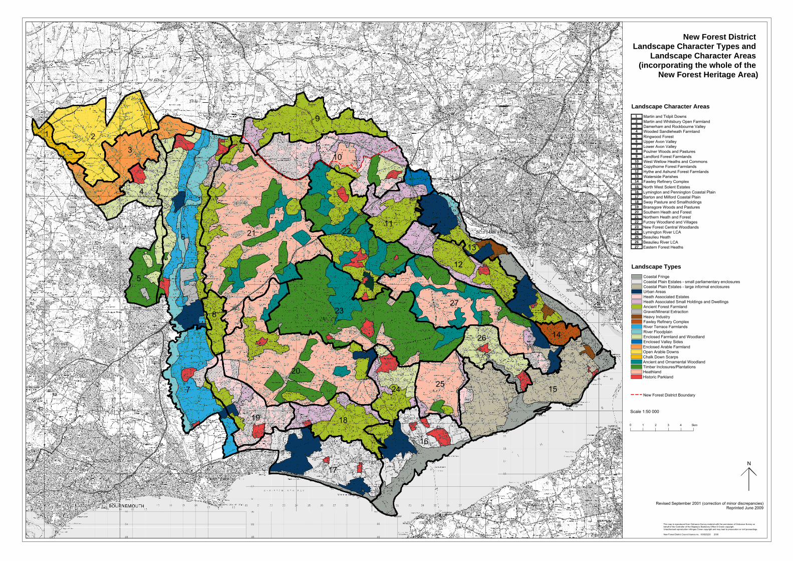
New Forest District Council 5km 4 3 2 1 0 Revised September 2001 (correction of minor discrepancies) Reprinted June 2009 N Scale 1:50 000 New Forest District Boundary 17 16 15 14 13 12 11 10 27 26 25 24 23 22 21 20 19 18 2 1 9 7 8 6 5 4 3 New Forest District Landscape Character Types and Landscape Character Areas (incorporating the whole of the New Forest Heritage Area) Enclosed Valley Sides Enclosed Farmland and Woodland West Wellow Heaths and Commons Landford Forest Farmlands Heathland Timber Inclosures/Plantations Ancient and Ornamental Woodland Chalk Down Scarps Open Arable Downs Enclosed Arable Farmland Urban Areas Coastal Plain Estates - large informal enclosures River Floodplain River Terrace Farmlands Historic Parkland Heavy Industry Gravel/Mineral Extraction Ancient Forest Farmland Heath Associated Small Holdings and Dwellings Heath Associated Estates Hythe and Ashurst Forest Farmlands Copythorne Forest Farmlands Coastal Plain Estates - small parliamentary enclosures Coastal Fringe Poulner Woods and Pastures Fawley Refinery Complex Lower Avon Valley Eastern Forest Heaths Upper Avon Valley Beaulieu River LCA Southern Heath and Forest Beaulieu Heath Ringwood Forest Lymington River LCA Wooded Sandleheath Farmland New Forest Central Woodlands Damerham and Rockbourne Valley Furzey Woodland and Villages Martin and Whitsbury Open Farmland Northern Heath and Forest Martin and Tidpit Downs Fawley Refinery Complex Bransgore Woods and Pastures Sway Pasture and Smallholdings Barton and Milford Coastal Plain Lymington and Pennington Coastal Plain North West Solent Estates Waterside Parishes Landscape Types Landscape Character Areas 18 16 14 13 12 27 26 25 24 23 22 21 20 19 17 15 11 10 9 8 7 6 5 4 3 2 1 This map is reproduced from Ordnance Survey material with the permission of Ordnance Survey on behalf of the Controller of Her Majesty's Stationery Office © Crown copyright. Unauthorised reproduction infringes Crown copyright and may lead to prosecution or civil proceedings. New Forest District Council licence no. 100026220 2009
Transcript of Landscape character map A0 50000
New Fore
st
Distric
t Cou
ncil
5km43210
Revised September 2001 (correction of minor discrepancies)Reprinted June 2009
N
Scale 1:50 000
New Forest District Boundary
1716151413121110
27262524232221201918
21
9
78
6543
New Forest District Landscape Character Types and
Landscape Character Areas (incorporating the whole of the
New Forest Heritage Area)
Enclosed Valley SidesEnclosed Farmland and Woodland
West Wellow Heaths and CommonsLandford Forest Farmlands
HeathlandTimber Inclosures/PlantationsAncient and Ornamental WoodlandChalk Down ScarpsOpen Arable DownsEnclosed Arable Farmland
Urban AreasCoastal Plain Estates - large informal enclosures
River FloodplainRiver Terrace Farmlands
Historic Parkland
Heavy IndustryGravel/Mineral ExtractionAncient Forest FarmlandHeath Associated Small Holdings and DwellingsHeath Associated Estates
Hythe and Ashurst Forest FarmlandsCopythorne Forest Farmlands
Coastal Plain Estates - small parliamentary enclosuresCoastal Fringe
Poulner Woods and Pastures
Fawley Refinery Complex
Lower Avon Valley
Eastern Forest Heaths
Upper Avon Valley
Beaulieu River LCA
Southern Heath and Forest
Beaulieu Heath
Ringwood Forest
Lymington River LCA
Wooded Sandleheath Farmland
New Forest Central Woodlands
Damerham and Rockbourne Valley
Furzey Woodland and Villages
Martin and Whitsbury Open Farmland
Northern Heath and Forest
Martin and Tidpit Downs
Fawley Refinery Complex
Bransgore Woods and PasturesSway Pasture and SmallholdingsBarton and Milford Coastal PlainLymington and Pennington Coastal PlainNorth West Solent Estates
Waterside Parishes
Landscape Types
Landscape Character Areas
18
16
14
13
12
27
26
2524
23
2221
20
19
17
15
11
10
9
8
7
6
5
4
3
21
This map is reproduced from Ordnance Survey material with the permission of Ordnance Survey onbehalf of the Controller of Her Majesty's Stationery Office © Crown copyright.Unauthorised reproduction infringes Crown copyright and may lead to prosecution or civil proceedings.
New Forest District Council licence no. 100026220 2009