Landscape and Visual Impact Assessment (LVIA) · BHP Billiton Iron Ore . ... Landscape and Visual...
68
360 Environmental Pty Ltd Orebody 31 Landscape and Visual Impact Assessment (LVIA) Prepared for: BHP Billiton Iron Ore July 2014
-
Upload
nguyenminh -
Category
Documents
-
view
217 -
download
2
Transcript of Landscape and Visual Impact Assessment (LVIA) · BHP Billiton Iron Ore . ... Landscape and Visual...

360 Environmental Pty Ltd
Orebody 31
Landscape and
Visual Impact
Assessment (LVIA)
Prepared for:
BHP Billiton Iron Ore
July 2014

360 Environmental Pty Ltd
Disclaimer
This report is issued in accordance with, and is subject to, the terms of the contract between the Client and 360
Environmental Pty Ltd, including, without limitation, the agreed scope of the report. To the extent permitted by law, 360
Environmental Pty Ltd shall not be liable in contract, tort (including, without limitation, negligence) or otherwise for any
use of, or reliance on, parts of this report without taking into account the report in its entirety and all previous and
subsequent reports. 360 Environmental Pty Ltd considers the contents of this report to be current as at the date it was
produced. This report, including each opinion, conclusion and recommendation it contains, should be considered in the
context of the report as a whole. The opinions, conclusions and recommendations in this report are limited by its agreed
scope. More extensive, or different, investigation, sampling and testing may have produced different results and therefore
different opinions, conclusions and recommendations. Subject to the terms of the contract between the Client and 360
Environmental Pty Ltd, copying, reproducing, disclosing or disseminating parts of this report is prohibited (except to the
extent required by law) unless the report is produced in its entirety including this cover page, without the prior written
consent of 360 Environmental Pty Ltd.
© Copyright 2014 360 Environmental Pty Ltd ACN 109 499 041
Document
Reference Revision Prepared by Reviewed by
Submitted to Client
Copies Date
317AB A INTERNAL DRAFT Jeevarayan Rao Felicity Jones - -
317AB B CLIENT DRAFT Jeevarayan Rao Sonya Brunt 1 Electronic (email) 11/06/14
317AB C CLIENT FINAL Jeevarayan Rao Felicity Jones 1 Electronic (email) 04/07/14

317AB Landscape and Visual Impact Assessment Orebody 31
BHP Billiton Iron Ore
360 Environmental Pty Ltd i
Executive Summary
360 Environmental Pty Ltd was commissioned by BHP Billiton Iron Ore to undertake a
Landscape and Visual Impact Assessment (LVIA) for the proposed Orebody 31 (OB31;
the Project) development. OB31 is located approximately 40 kilometers (km) east of the
Newman Township, in the Shire of East Pilbara. Being situated directly east of the
existing Orebody 17 and 18 operations at Shovellana Hill, OB31 is intended as a long
term replacement for these projects.
The LVIA consisted of three assessment phases, a desktop, field and impact
assessment. The desktop assessment identified 11 potential sensitive receptor sites
based on a risk -of-impact and site significance matrix, which were then visited and
surveyed during the field assessment. The field assessment identified seven sites out of
the 11 in the Newman region that were of high socio-cultural value that may potentially
be impacted by the Project. These seven sites were then further assessed in the impact
assessment phase. An additional eighth ‘site’, a 103 km length of the Great Northern
Highway and Marble Bar Road was also analysed in an effort to understand a larger
extent of potential impacts from the Project.
Viewshed and photomontage analysis conducted on these sites based on information
collected during the field study showed that direct impacts on landscape character and
visual amenity were relatively low (the maximum impact to a site’s viewshed peaked at
1.11%). This is likely due to a combination of various factors. Similarly, impacts to
landscape character from clearing activities (both at the local and regional level was
extremely low (0.05% – 0.11%), as was impacts to local Land Systems (0.01% – 0.37%).
Impacts to important transport networks were also very low, with the impact on the total
viewshed of the 103 km section of road peaking at only 0.65%.
The low impact level of the project is thought to be due to a combination of factors. The
topographical location of the Project naturally mitigates impact in that it is screened from
impacts to the south by Opthalmia Range and to the north by the dense screens of
vegetation along the numerous creeks in the region (including the Fortescue River). In
addition to this, most sensitive receptors are located to the east of the Fortescue River,
which contains dense stands of tall vegetation (especially in areas along the Marble Bar
Road), which effectively act to screen out views of the Project Area.
The findings of this study also suggest that impacts are likely to stem from the
surrounding developments rather than from OB31, however indirect impacts in the form
of dust may be slightly intensified which in turn may result in impacts to visual amenity.

317AB Landscape and Visual Impact Assessment Orebody 31
BHP Billiton Iron Ore
360 Environmental Pty Ltd
Table of Contents
1 Introduction .................................................................................................. 1
1.1 Background ............................................................................................................ 1
1.2 Legislative Context ................................................................................................ 1
1.3 Scope and Objectives ............................................................................................ 3
2 The Existing Environment ............................................................................. 6
2.1 Environmental Setting ............................................................................................ 6
2.2 Socio-economic Setting ......................................................................................... 9
3 Methodology ...............................................................................................12
3.1 Desktop Assessment ........................................................................................... 12
3.2 Field Assessment ................................................................................................. 16
3.3 Visual Impact Assessment ................................................................................... 20
4 Results ........................................................................................................25
4.1 Field Assessment ................................................................................................. 25
4.2 Visual Impact Assessment ................................................................................... 41
5 Discussion ...................................................................................................50
5.1 Direct Impacts on Visual Amenity ........................................................................ 50
5.2 Cumulative Impacts on Visual Impact .................................................................. 51
6 Conclusion ...................................................................................................52
6.1 Summary of Impacts ............................................................................................ 52
7 Limitations ...................................................................................................53
8 References ..................................................................................................54

317AB Landscape and Visual Impact Assessment Orebody 31
BHP Billiton Iron Ore
360 Environmental Pty Ltd i
List of Tables
Table 1. WAPC Criteria for Site Significance ................................................................. 13
Table 2. Vulnerability of Sites: Potential Impact Versus Likelihood ................................ 15
Table 3. Field Assessment Criteria ................................................................................. 17
Table 4. Surveyed Sites .................................................................................................. 25
Table 5. K1 – Radio Tower Hill lookout site characteristics ............................................. 26
Table 6. K2 – Opthalmia Dam picnic area site characteristics ........................................ 29
Table 7. K3 – Opthalmia Dam wall site characteristics ................................................... 30
Table 8. K4 – Marble Bar Road rest stop 1 site characteristics ...................................... 32
Table 9. K5 – Marble Bar Road rest stop 2 site characteristics ...................................... 34
Table 10. K6 – Kalgan Pool site characteristics ............................................................. 36
Table 11. K7 – Round Hill site characteristics ................................................................. 38
Table 12. K6 – Round Hill site characteristics ................................................................. 40
Table 13. Impacts to LCTs and Land Systems ................................................................ 41
List of Figures
Figure 1. Project Location ................................................................................................. 4
Figure 2. Conceptual Project Layout ................................................................................. 5
Figure 3. Landscape Character Types ............................................................................ 10
Figure 4. Land Systems .................................................................................................. 11
Figure 5. 3D Site Model .................................................................................................. 20
Figure 6. Pre and Post Development Terrain Models ..................................................... 21
Figure 7. Example of Viewshed Analysis Output from a Hypothetical Viewpoint............ 22
Figure 8. Surveyed Sites ................................................................................................. 24
Figure 9. K1 – Radio Tower Hill, Newman ....................................................................... 42
Figure 10. K2 – Opthalmia Dam Picnic Area ................................................................... 43
Figure 11. K3 – Opthalmia Dam Wall .............................................................................. 44
Figure 12. K4 – Marble Bar Road Rest Stop 1 ................................................................ 45
Figure 13. K5 – Marble Bar Road Rest Stop 2 ................................................................ 46
Figure 14. K6 – Kalgan Pool ............................................................................................ 47

317AB Landscape and Visual Impact Assessment Orebody 31
BHP Billiton Iron Ore
360 Environmental Pty Ltd ii
Figure 15. K7 – Round Hill ............................................................................................... 48
Figure 16. Regional Roads Viewshed Analysis ................................................................ 49
List of Plates
Plate 1. View experiences from different landform combinations ................................... 19
Plate 2. K1 - Radio Tower Hill lookout ............................................................................. 26
Plate 3. K2 – Opthalmia Dam picnic area ........................................................................ 28
Plate 4. K3 – Opthalmia Dam wall .................................................................................. 30
Plate 5. K4 – Marble Bar Road rest stop 1 ..................................................................... 32
Plate 6. K5 – Marble Bar Road rest stop 2 ..................................................................... 33
Plate 7. K6 – Kalgan Pool ................................................................................................ 35
Plate 8. K7 – Round Hill .................................................................................................. 37
Plate 9. K8 – Great Northern Hwy and Marble Bar Road (aerial image: Landgate 2013)
............................................................................................................................ 39
List of Appendices
Appendix A: Other Sites Surveyed ................................................................................. 56

317AB Landscape and Visual Impact Assessment Orebody 31
BHP Billiton Iron Ore
360 Environmental Pty Ltd iii
Definitions of Terms, Acronyms and
Abbreviations
TERM DEFINITION
Background Five to ten kilometres from the viewer.
Foreground From the viewer to one kilometre away.
Georeferenced The attribution of a coordinate system to data which corresponds to real life.
Landscape
A spatially heterogeneous area, scaled relative to the process of interest. Within
landscapes it is usually possible to define a series of different ecosystems,
landforms, habitats and natural or man-made features.
Landscape
Character Type/
Unit
A large scale geographic area with broad similarities in landform types, soils, and
vegetation.
Land system A fine scale geographic area with a specific combination of landforms, soils,
vegetation and drainage patterns
Midground One to five kilometres away from the viewer.
Valued Landscape
Characteristic
The resulting landscape characteristic that results from a combination of natural
features. E.g. panoramic, coastal.
View Experience The relative levels of appreciation a viewer experiences for a particular view
relative to the landscape. E.g. negative, neutral, positive.
Viewshed The theoretical area of visibility from a given point.
Visual Amenity The values and services that result from a view on a receptor, usually an
individual or community.
Visual Impact The changes to visual amenity as a result of a development.
Visual Plane The theoretical straight line of sight from a viewer to an object.
Visual Risk The likelihood and consequence of positive and negative visual impact.
Mitigation Strategy A strategy to minimise visual impact.
ACRONYM DEFINITION
DMP Department of Mines and Petroleum, Western Australia
DPI Department of Planning and Infrastructure, Western Australia
DSEWPaC Department of Sustainability, Environment, Water, Population and Communities
(now the Department of the Environment)
EPA Environmental Protection Authority
GDA 1994 Geodetic Datum of Australia 1994
LCT Landscape Character Type
LVIA Landscape and Visual Impact Assessment
MGA 1994 Map Grid of Australia – based on the GDA 1994 datum
OSA Overburden Storage Area
TIN Triangulated Irregular Network
UTM Universal Transverse Mercator
WAPC Western Australian Planning Commission
ABBREVIATION DEFINITION

317AB Landscape and Visual Impact Assessment Orebody 31
BHP Billiton Iron Ore
360 Environmental Pty Ltd iv
ha Hectare
Hwy Highway
m Metre
km Kilometre
km2 Square kilometre
Mtpa Million tonnes per annum

317AB Landscape and Visual Impact Assessment Orebody 31
BHP Billiton Iron Ore
360 Environmental Pty Ltd 1
1 Introduction
1.1 Background
Orebody 31 (OB31; the Project) is located approximately 40 kilometers (km) east of the
Newman Township, in the Shire of East Pilbara (Figure 1). Being situated directly east of
the existing Orebody 17 and 18 operations at Wheelara Hill, OB31 is currently intended
as a long term replacement for these projects. The Project is situated between the
Newman and Jimblebar Iron Ore Hubs. The location of OB31 in relation to surrounding
operations is shown in Figure 1.
At present, the project is envisaged to involve the mining of one open cut pit that is
largely below the water table (through conventional drill and blast techniques) as well as
the construction of two Overburden Storage Areas (OSAs), a primary crusher and
conveyor infrastructure. Ore is proposed to be produced at an initial rate of
approximately 15 million tonnes per annum (Mtpa) with a potential full throughput of 30
Mtpa. It is anticipated that the Project will house one primary crusher, with ore most
likely being initially transported via overland conveyors to existing the Ore Handling Plant
(OHP), ore stockpile and Train Load Out (TLO) facility at OB17/18. Should throughput
be increased to 30 Mtpa, a secondary conveyor may be constructed to convey ore to the
Jimblebar OHP, stockpile and TLO facility at Shovellana Hill (Figure 2).
360 Environmental was commissioned by BHP Billiton Iron Ore (BHPBIO) to conduct a
Landscape and Visual Impact Assessment (LVIA) to support the environmental impact
assessment and approvals required for the project.
1.2 Legislative Context
Legislative instruments exist at the Federal, State and Local government levels which
directly or indirectly support the protection of landscapes and their resulting visual
amenity. These are outlined below.
1.2.1 Federal Legislation and Positions
Under Section 528 of the Environment Protection and Biodiversity Conservation Act
1999, the term ‘Environment’ is defined as (DSEWPaC 2012):
(a) Ecosystems and their constituent parts, including people and
communities; and
(b) Natural and physical resources; and
(c) The qualities and characteristics of locations, places and areas; and
(d) Heritage values of places; and
(e) The social economic and cultural aspects of a thing mentioned in
paragraph (a), (b) or (c).

317AB Landscape and Visual Impact Assessment Orebody 31
BHP Billiton Iron Ore
360 Environmental Pty Ltd 2
Under this definition, impacts to visual amenity can be considered an ‘environmental’
impact, as it falls under the definition in (c).
1.2.2 State Legislation and Positions
When a proposal is assessed under the Environmental Protection Act 1986 the
Environmental Protection Authority (EPA) may consider a proposal’s impacts to visual
amenity under its guidance framework for environmental factors based on a number of
environmental factors and protection objectives listed in Environmental Assessment
Guideline for Environmental factors and objectives (EPA 2013a). The objectives relevant
to landscape and visual impacts are:
Landforms: “To maintain the variety, integrity, ecological functions and
environmental values of landforms and soils”;
Air Quality: “To maintain air quality for the protection of the environment and
human health and amenity”; and
Amenity: “To ensure that impacts to amenity are reduced as low as reasonably
practicable”.
Although the Landforms factor does not contain mention of visual impact or amenity, it is
considered relevant as intact landforms often make up intact landscapes (as assessed by
this study) which can reflect higher levels of ecological function and biodiversity (The
Landscape Institute 2002; Ludwig et al. 1996).
There are also a number of State policies that highlight the need for visual impact
assessment to be considered during the planning phase of developments. These include
the Western Australian State Planning Framework and the Pilbara Planning and
Infrastructure Framework.
The Western Australian Planning Commission’s (WAPC) State Planning Policy No. 2:
Environment and Natural Resource Policy for Western Australia (WAPC 2003) states
that the objective for planning is to:
“identify and protect landscapes with high natural resource values (such as
ecological, aesthetic or geological)”;
“consider the capacity of the landscape to absorb new activities and incorporate
building design and siting criteria to ensure that new developments are consistent
and sensitive to the character and quality of the landscape”; and
“consider the need for a landscape or visual impact assessment for development
proposals that may impact upon sensitive landscapes”.
317AB Landscape and Visual Impact Assessment Orebody 31
BHP Billiton Iron Ore
360 Environmental Pty Ltd 3
The WAPC also encourages proponents to develop appropriate management strategies
that can contribute to the maintenance and enhancement of high value landscapes. The
WAPC’s Pilbara Planning and Infrastructure Framework (WAPC 2012) highlights the
need to:
“safeguard and enhance significant natural landscape assets and cultural heritage
values”; and
“protect and manage the region’s cultural heritage, arts including indigenous
significant places, and landscapes of significance”.
1.3 Scope and Objectives
The broad objectives of the OB31 LVIA are to:
Identify key landscape values within and surrounding the proposed development;
Identify vantage points and corridors where these key sites may be viewed /
accessed / experienced;
Evaluate the visual amenity associated with these landscape values – the way the
landscape is viewed, experienced and valued;
Assess the potential impacts on visual amenity resulting from the proposed
development, including cumulative impacts from other existing and proposed
projects;
Assess the significance of these impacts; and
Describe management and mitigation measures that will reduce impacts to
landscape and visual amenity (presented in a separate document).
These objectives are considered in line with LVIA assessment methodology guidelines,
as set out in the Department of Planning and Infrastructure’s (DPI) Visual Landscape
Planning in Western Australia: a Manual for Evaluation, Assessment, Siting and Design
(DPI 2007), and in the Guidelines for Landscape and Visual Impact Assessment (3rd
Edition, 2013), from the Landscape Institute and Institute of Environmental Management
and Assessment (UK).

CREATED APPROVED REVISIONCHECKED
Coord inate System: GDA 1994 MGA Zone 50
!(
!(
!(
!(
!(!(
!(
!(
!(!(
!(
!(
!(
!(
!(
!(
!(
OREBODY 31
OPTHALMIA RANGE
F ORT ESCU
E RIVE
RFORTESC
UE RIVER
Jimble
bar C
r k
Warraw
anda
Cr k
C ara
mulla
Crk
K a lgan Crk
#MT NEWMAN(1057m)
GR EAT NORTHERN HW Y
MA RBLE
BAR
RD
Orebody 18Orebody 25
Orebody 35
Orebody 30
Orebody 23
Orebody 29Mt Whaleback
Hope Downs 4
Jimblebar (Wheelara 4)NEWMAN
760000
760000
780000
780000
800000
800000
820000
820000
840000
840000
860000
860000
7380
000
7380
000
7400
000
7400
000
7420
000
7420
000
7440
000
7440
000
7460
000
7460
000
Ê
0 5 10 15 202.5
Kilometers
Legend!( Localities
WatercoursesOrebody 31 Project Areas
OSAPit
RoadsGreat Northern HighwayOther Roads
Existing Major Iron Ore Mines!( BHP Billiton Iron Ore Operated!( Other Operators
Rail InfrastructureBHP Billiton Iron Ore Rail LinesOther Operator Rail Lines
!( !(
!(
!(
NEWMANTOM PRICE
PARABURDOO
PORT HEDLANDLOCALITY MAP
DATEDRAWING ID
JJ FJ TS
- NOTE THAT POSITION ERRORS CA N BE >5M IN SOME AREAS- LOCALITY MAP SOURCED FROM LANDGATE 2006- STREET DIRECTORY MAP S OURCED FROM STREETSMART 2008- AERIAL PHOTOGRAPHY S OURCED FROM LANDGATE 2012 (© Wester n Australian Land In formation Authority 2013)
22/05/2014
K:\Admin\Templates\New_A4L.mxd
0
HORIZONTAL DATUM AND PR OJEC TION317
BHP Billiton Iron OreOrebody 31Landscape and Visual ImpactAssessment (LVIA)
COPYRIGHT: THIS DOCUMENT IS AND SHALL REMAIN THE PROPERTY OF 360 ENVIRONMENTAL. THIS DOCUMENT MAY ONLY BE USED FOR THE PURPOSE FOR WHICH IT WAS COMMISSIONED AND IN ACCORDANCE WITH THE TERMS OF ENGAGEMENT FOR THE COMMISSION. 360 ENVIRONMENTAL DOES NOT HOLD ANY RESPONSIBILITY FOR THE MISUSE OF THIS DOCUMENT.
@ A41:500,000
Figure 1 - Site Location
a 10 B erm onds ey S t, Wes t Leederv ille, 6007 WAt (08) 9388 8360f (08) 9381 2360w www.360environmental .com.au

CREATED APPROVED REVISIONCHECKED
Coord inate System: GDA 1994 MGA Zone 50
!(
!(
!(
!(
!(
!(
!(!(
OREBODY 31
HV HAUL ROAD
CONVEYOR SYSTEMPRIMARY CRUSHING
FACILITYOrebody 18
Jimblebar (Wheelara 4)
810000
810000
815000
815000
820000
820000
825000
8250007410
000
7410
000
7415
000
7415
000
7420
000
7420
000
Ê
0 1,000 2,000 3,000500
Meters
LegendOrebody 31 Project Areas
OSAPitHaul Roads & Overland Conveyors
Existing Major Iron Ore Mines!( BHP Billiton Iron Ore Operated!( Other Operators
Rail InfrastructureBHP Billiton Iron Ore Rail Lines
Site Model Elevation (mAHD)605m - 640m570m - 605m535m - 570m500m - 535m465m - 500m430m - 465m395m - 430m360m - 395m
!(
!(!(
!(
!(!(NEWMAN JIGGALONG
MUNDIWINDI
MOUNT NEWMAN
LOCALITY MAP
DATEDRAWING ID
JJ FJ TS
- NOTE THAT POSITION ERRORS CA N BE >5M IN SOME AREAS- LOCALITY MAP SOURCED FROM LANDGATE 2006- EXISTING MAJOR IRON ORE MINES SOURCED FROM BHP BILLITON IRON ORE, ADAPTED B Y 360 ENVIRONMENTAL 2014- ALL OTHER DATA SOURCE D FROM B HP BILLITON IRON ORE- AERIAL PHOTOGRAPHY S OURCED FROM LANDGATE 2013 (© Wester n Australian Land In formation Authority 2013)
22/05/2014
K:\Projects\4.0 RES\317 OB31 LVIA\Figures\Report Figures
0
HORIZONTAL DATUM AND PR OJEC TION317
BHP Billiton Iron OreOrebody 31
Landscape and Visual ImpactAssessment (LVIA)
COPYRIGHT: THIS DOCUMENT IS AND SHALL REMAIN THE PROPERTY OF 360 ENVIRONMENTAL. THIS DOCUMENT MAY ONLY BE USED FOR THE PURPOSE FOR WHICH IT WAS COMMISSIONED AND IN ACCORDANCE WITH THE TERMS OF ENGAGEMENT FOR THE COMMISSION. 360 ENVIRONMENTAL DOES NOT HOLD ANY RESPONSIBILITY FOR THE MISUSE OF THIS DOCUMENT.
@ A41:75,000
Figure 2 - Site Layout
a 10 B erm onds ey S t, Wes t Leederv ille, 6007 WAt (08) 9388 8360f (08) 9381 2360w www.360environmental .com.au

317AB Landscape and Visual Impact Assessment Orebody 31
BHP Billiton Iron Ore
360 Environmental Pty Ltd 6
2 The Existing Environment
2.1 Environmental Setting
2.1.1 Landscape Character
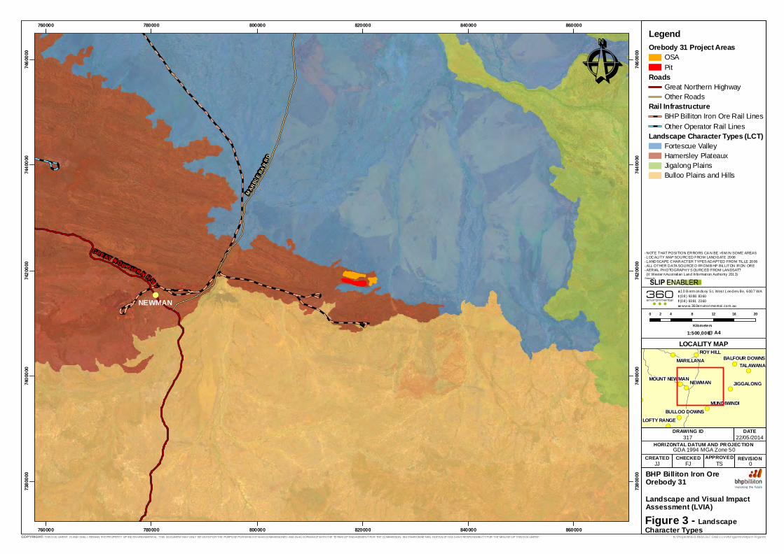
The Project falls primarily within the Hamersley Plateaux Landscape Zone within the
Pilbara Bioregion, which forms the large part of the Landscape Character Type (LCT) of
the Newman region (Figure 3). Landscape Character is a broad grouping of similar
landforms, soils and vegetation. The Hamersley Plateaux LCT can broadly be described
as (adapted from Tille 2006):
“Hills and dissected plateaux (with some stony plains and hardpan wash
plains) on sedimentary and volcanic rocks of the Hamersley Basin
(Opthalmia Fold Belt). Stony soils with Red shallow loams and some
Red/brown non-cracking clays and Red loamy earths. Spinifex grasslands
with snappy gum and kanji (and some mulga shrublands).”
A smaller area falls within the Fortescue Valley LCT, described as:
“Alluvial plains, hardpan wash plains and sandplains (with stony plains,
floodplains and some salt lakes) on alluvial deposits over sedimentary
rocks of the Hamersley Basin. Red deep sands, Red loamy earths and
Red/brown non-cracking clays with some Red shallow loams and Hard
cracking clays. Mulga shrublands and spinifex grasslands (with some
tussock grasslands and halophytic shrublands).”
A more specific and level of detail, the OB31 Project area falls within several land
systems as described by Van Vreeswyk et al (2004) in An inventory and condition survey
of the Pilbara Region, Western Australia (Tille 2006; Figure 4). These systems are
described as:
Newman System: Rugged jaspilite plateaux, ridges and mountains supporting
hard spinifex grasslands (49.13%);
Boolgeeda System: Stony lower slopes and plains below hill systems supporting
hard and soft spinifex grasslands or mulga shrublands (41.58%);
McKay: Hills, ridges, plateaux remnants and breakaways of meta sedimentary and
sedimentary rocks supporting hard spinifex grasslands (0.86%); and
Washplain System: Hardpan plains supporting groved and hard spinifex
grasslands (8.43%).

317AB Landscape and Visual Impact Assessment Orebody 31
BHP Billiton Iron Ore
360 Environmental Pty Ltd 7
2.1.2 Newman Land System
The Newman system is a large land system in the central Pilbara and is characteristic of
Pilbara landscapes. The geomorphology of the Newman System is described as:
“Erosional surfaces; plateaux and mountains - extensive high plateaux,
mountains and strike ridges with vertical escarpments and steep scree
slopes and more gently inclined lower slopes; moderately spaced dendritic
and rectangular tributary drainage patterns of narrow valleys and gorges
with narrow drainage floors and channels. Relief up to 450 m.”
It is estimated that approximately 70% of this land system consists of plateaux, ridges,
mountains and hills. Twenty percent of the land system consists of lower slopes with the
remaining 10% split evenly between stony plains and narrow drainage floors with
channels (Van Vreeswyk et al 2004). The majority of vegetation in this land system is
described as:
“Hummock grasslands of Triodia wiseana, T.brizoides, T. plurinervata (hard
spinifex) with very scattered to scattered shrubs and trees including Acacia
and Senna spp., Grevillea wickhamii (Wickham’s grevillea), Eucalyptus
leucophloia (snappy gum) and other eucalypts . Occasionally hummock grass
is Triodia biflora (soft spinifex).”
The Newman System is of high socioeconomic importance due to the large number of iron
ore resources in the form of banded iron formations being found in it.
2.1.3 Boolgeeda Land System
The Boolgeeda Land system is commonly associated with the Newman Land System,
being downslope of it. The geomorphology of this System is described as:
“Predominantly depositional surfaces; very gently inclined stony slopes and
plains below hill systems becoming almost level further downslope; closely
spaced, dendritic and sub-parallel drainage lines. Relief up to about 20 m.”
It is estimated that 65% of this land system consists of stony lower plains, with 20% of
stony slopes and upper plains, 10% of narrow drainage floors and channels, 4% of low hills
and rises and the remaining 1% being made up of groves.
Vegetation largely consists of a mixture of that found in the Washplain and Newman
Systems and is described as:
“Hummock grasslands T.wiseana, T. lanigera (hard spinifex) or T. pungens
(soft spinifex) (PHSG, PSSG). Also scattered to moderately close tall
shrublands of A. aneura and other acacias with hard and soft spinifex
ground layer.”
The proximity of the Boolgeeda Land System to the Newman System, as well as its
generally low relief and gentle slope has made it ideal for the setting up of processing

317AB Landscape and Visual Impact Assessment Orebody 31
BHP Billiton Iron Ore
360 Environmental Pty Ltd 8
infrastructure. The processing facilities and TLOs for BHPBIO’s Jimblebar, Shovellana,
OB24 and Area C operations, as well as Rio Tinto’s Marandoo and Yandi operations are
largely set within this Land System.
2.1.4 McKay Land System
The geomorphology of this land system is described as:
“Erosional surfaces; hill tracts, ridges, plateaux remnants and breakaways
with steep upper slopes and more gently inclined lower footslopes,
restricted stony plains and interfluves; moderately spaced tributary
drainage patterns incised in narrow valleys in upper parts becoming
broader and more widely spaced downstream. Relief up to 100 m.”
It is estimated that 60% of this land system consists of hills, ridges and plateaux
remnants, 20% of stony plains, 10% of lower footslopes to hills, ridges and
plateaux, 8% of drainage floors and 2% of breakaways (indurated mesa caps of
ironstone or laterite).
Vegetation within this land system is most commonly described as:
“Hummock grasslands of Triodia lanigera, T. wiseana (hard spinifex) with
isolated to scattered Acacia spp. shrubs or Eucalyptus leucophloia
(snappy gum) trees.”
2.1.5 Washplain Land System
The geomorphology of the Washplain System is described as:
“Depositional surfaces; level alluvial hardpan plains subject to overland
sheet flow, discrete drainage foci(groves) arranged with long axes at right
angles to direction of sheet flow and drainage tracts receiving more
concentrated flow,occasional channels; minor stony plains and sandplains.
Relief up to 10 m.”
Approximately 60% of this system consists of alluvial hardpan plains, 15% of groves, 14%
of drainage tracts, 6% of stony plains and the 3% is made up of sandplains (Van
Vreeswyk et al. 2004).
The most abundant vegetation association of the Washplain System’s is described as:
“Herbfields with isolated shrubs or very scattered to scattered shrublands
of Acacia aneura, Eremophila cuneifolia (royal poverty bush) other
eremophilas, Senna spp. and small Maireana spp.”

317AB Landscape and Visual Impact Assessment Orebody 31
BHP Billiton Iron Ore
360 Environmental Pty Ltd 9
2.2 Socio-economic Setting
2.2.1 Land uses
Mining is considered the main land use in the Newman area. BHP Billiton Iron Ore owns
and operates a number of mining operations around the Newman area which are known
as the Whaleback Hub, the Eastern Ridge Hub and the Jimblebar Hub. The hubs consist
of the following grouped deposits/mines:
Whaleback Hub (current operations - Whaleback, OB18, OB29, OB30, OB35 and
the proposed OB31);
Eastern Ridge Hub (current operations OB23, OB24 and OB25); and
Jimblebar Hub (current operations Jimblebar and Wheelarra 4).
2.2.2 Overview of the Newman Township and Surrounding Areas
The Project is located approximately 40 km east of the Newman Township, Newman is
the largest town in the East Pilbara with the population of the township growing
exponentially since 2003. In 2012 the residential population of Newman was 5,478
(Australian Bureau of Statistics 2012). Adding to the permanent population is the fly in fly
out workforce averaging around 4,000 people.
The Orebody 31 project area lies within the traditional lands of the Nyiyaparli People. The
Nyiyaparli People are the Traditional Owners of approximately 36,684 km2 of land and
waters in the east Pilbara region, including the township of Newman.
Newman is also an access point for a number of sites with environmental or social values
including:
Karijini National Park (approximately 200 km west of Newman);
Karlamilyi (Rudall River) National Park (approximately 300 km north east of
Newman);
Opthalmia Dam, a popular swimming and recreation spot (fishing and sailing)
(approximately 20 km out of Newman);
Kalgan Pool/Creek (approximately 20 km out of Newman);
Wanna Munna rock are and pool site (approximately 30 km out of Newman);
Silent Gorge (approximately 12 km out of Newman); and
Weeli Wolli Springs (approximately 100 km out of Newman).
The area surrounding the Newman Township is also valued for its unique flora and fauna.
Between July to September each year a number of tourists visit the area to witness the
flowering of Spinifex grass (Newman Visitor Centre 2013).
CREATED APPROVED REVISIONCHECKED
Coord inate System: GDA 1994 MGA Zone 50
!(
GRE AT N ORTHER N H WY
M ARBL
E BA R
R D
NEWMAN
760000
760000
780000
780000
800000
800000
820000
820000
840000
840000
860000
860000
7380
000
7380
000
7400
000
7400
000
7420
000
7420
000
7440
000
7440
000
7460
000
7460
000
Ê
0 4 8 12 16 202
Kilometers
LegendOrebody 31 Project Areas
OSAPit
RoadsGreat Northern HighwayOther Roads
Rail InfrastructureBHP Billiton Iron Ore Rail LinesOther Operator Rail Lines
Landscape Character Types (LCT)Fortescue ValleyHamersley PlateauxJigalong PlainsBulloo Plains and Hills
!(
!(
!(!(
!(!(
!(
!(
!(
!(
!(
!(!(NEWMAN
TALAWANA
ROY HILL
JIGGALONG
MARILLANA
MUNDIWINDI
LOFTY RANGE
MOUNT NEWMAN
BULLOO DOWNS
BALFOUR DOWNS
LOCALITY MAP
DATEDRAWING ID
JJ FJ TS
- NOTE THAT POSITION ERRORS CA N BE >5M IN SOME AREAS- LOCALITY MAP SOURCED FROM LANDGATE 2006- LANDSCAPE CHARACTER TYPES ADAPTED FROM TILLE 2006- ALL OTHER DATA SOURCE D FROM B HP BILLITON IRON ORE- AERIAL PHOTOGRAPHY S OURCED FROM LANDSAT7 (© Wester n Australian Land In formation Authority 2013)
22/05/2014
K:\Projects\4.0 RES\317 OB31 LVIA\Figures\Report Figures
0
HORIZONTAL DATUM AND PR OJEC TION317
BHP Billiton Iron OreOrebody 31Landscape and Visual ImpactAssessment (LVIA)
COPYRIGHT: THIS DOCUMENT IS AND SHALL REMAIN THE PROPERTY OF 360 ENVIRONMENTAL. THIS DOCUMENT MAY ONLY BE USED FOR THE PURPOSE FOR WHICH IT WAS COMMISSIONED AND IN ACCORDANCE WITH THE TERMS OF ENGAGEMENT FOR THE COMMISSION. 360 ENVIRONMENTAL DOES NOT HOLD ANY RESPONSIBILITY FOR THE MISUSE OF THIS DOCUMENT.
@ A41:500,000
Figure 3 - Landscape Character Types
a 10 B erm onds ey S t, Wes t Leederv ille, 6007 WAt (08) 9388 8360f (08) 9381 2360w www.360environmental .com.au

CREATED APPROVED REVISIONCHECKED
Coord inate System: GDA 1994 MGA Zone 50
DIV
DIV
SYL
NEW
TLG
BGD
PRA
NEW
SYL
RIV
WSP
SYL
BGD
SYL
JAM
FTC
MCK
WSP
FTC
PRA
NEW
BGD
FAN
DIV
NEW
DIVZEB
PRA
WSP
SYL
DIV
DIV
MCKDIV
JAMDIV
RIV
JAM
NEW
ROC
WSP
RIV
DIV WSP
SYL
MCK
NEW
CAD
DIV
WSP
WSP
NEW
MCK
DIV
FTC
BGD
NEW
NEW
NEW
MCK
NEW
NEW
NEW
NEW
WSP
PRA
LAT
SYL
MCK
NEW
DIV
NEW
NEW
NEW
PRA
PRA
RIV
RIVDIV
CAD
RIV
LAT
DIV
NEW
RIV
NEW
RIV
DIV
MCK
DIV
TLG
RIVDIV
MARB LE B
AR R
D
800000
800000
810000
810000
820000
820000
830000
830000
7400
000
7400
000
7410
000
7410
000
7420
000
7420
000
7430
000
7430
000Ê
0 2 4 6 81
Kilometers
LegendOrebody 31 Project Areas
OSAPitInfrastructure
Land SystemsADR - Adrian SystemBGD - Boolgeeda SystemCAD - Cadgie SystemDIV - Divide SystemELI - Elimunna SystemFAN - Fan SystemFTC - Fortescue SystemJAM - Jamindie SystemLAT - Laterite SystemMCK - McKay SystemNEW - Newman SystemPRA - Prairie SystemRIV - River SystemROC - Rocklea SystemSYL - Sylvania SystemTLG - Talga SystemWSP - Washplain SystemZebra System
!(
!(
!(
!(!(
!(
!(
!(
!(
!(
!(
!(
!(!(NEWMAN
TALAWANA
ROY HILL
JIGGALONG
MARILLANA
MUNDIWINDI
MOUNT NEWMAN
BULLOO DOWNS
BALFOUR DOWNS
LOCALITY MAP
DATEDRAWING ID
JJ FJ TS
- NOTE THAT POSITION ERRORS CA N BE >5M IN SOME AREAS- LOCALITY MAP SOURCED FROM LANDGATE 2006- LAND SY STEM S ADAPTE D FROM TILLE 2006- ALL OTHER DATA SOURCE D FROM B HP BILLITON IRON ORE- AERIAL PHOTOGRAPHY S OURCED FROM LANDSAT7 (© Wester n Australian Land In formation Authority 2013)
22/05/2014
K:\Projects\4.0 RES\317 OB31 LVIA\Figures\Report Figures
0
HORIZONTAL DATUM AND PR OJEC TION317
BHP Billiton Iron OreOrebody 31Landscape and Visual ImpactAssessment (LVIA)
COPYRIGHT: THIS DOCUMENT IS AND SHALL REMAIN THE PROPERTY OF 360 ENVIRONMENTAL. THIS DOCUMENT MAY ONLY BE USED FOR THE PURPOSE FOR WHICH IT WAS COMMISSIONED AND IN ACCORDANCE WITH THE TERMS OF ENGAGEMENT FOR THE COMMISSION. 360 ENVIRONMENTAL DOES NOT HOLD ANY RESPONSIBILITY FOR THE MISUSE OF THIS DOCUMENT.
@ A41:200,000
Figure 4 - Land Systems
a 10 B erm onds ey S t, Wes t Leederv ille, 6007 WAt (08) 9388 8360f (08) 9381 2360w www.360environmental .com.au
Unit Land System Name Land System DescriptionADR Adrian System Stony plains and low silcrete hills supporting hard spinifex grasslands.BGD Boolgeeda System Stony low er slopes and plains below hill systems supporting hard and soft spinifex grasslands or mulga shrublands.CAD Cadgie System Hardpan plains w ith thin sand cover and sandy banks supporting mulga shrublands w ith soft and hard spinifex.DIV Divide System Gently undulating sandplains w ith minor dunes, supporting hard spinifex hummock grasslands w ith numerous shrubs.ELI Elimunna System Stony plains on basalt supporting sparse acacia and cassia shrublands and patchy tussock grasslands.FAN Fan System Washplains and gilgai plains supporting groved mulga tall shrublands and minor tussock grasslands.FTC Fortescue System Alluvial plains and f lood plains supporting patchy grassy eucalypt and acacia w oodlands and shrublands and tussock grasslands.JAM Jamindie System Stony hardpan plains and rises supporting groved mulga shrublands, occasionally w ith spinifex understorey.LAT Laterite System Low lateritic plateaux, mesas, buttes and gravelly rises and plains supporting sparse mulga shrublands.MCK McKay System Hills, ridges, plateaux remnants and breakaw ays of meta sedimentary and sedimentary rocks supporting hard spinifex grasslands w ith acacias and occasional eucalypts.NEW New man System Rugged jaspilite plateaux, ridges and mountains supporting hard spinifex grasslands.PRA Prairie System Gently undulating stony plains and granite hills supporting acacia-eremophila-cassia shrublands and minor soft spinifex grasslands.RIV River System Narrow , seasonally active f lood plains and major river channels supporting moderately close, tall shrublands or w oodlands of acacias and fringing communities of eucalypts sometimes w ith tussock grasses or spinifex.ROC Rocklea System Basalt hills, plateaux, low er slopes and minor stony plains supporting hard spinifex and occasionally soft spinifex grasslands w ith scattered shrubs.SYL Sylvania System Gritty surfaced plains and low rises on granite supporting acacia-eremophila-cassia shrublands.TLG Talga System Hills and ridges of greenstone and chert and stony plains supporting hard and soft spinifex grasslands.WSP Washplain System Hardpan plains supporting groved mulga shrublands.ZEB Zebra System Hardpan plains w ith large linear gravelly sand banks supporting acacia tall shrublands w ith soft and hard spinifex.

317AB Landscape and Visual Impact Assessment Orebody 31
BHP Billiton Iron Ore
360 Environmental Pty Ltd 12
3 Methodology
3.1 Desktop Assessment
3.1.1 Viewpoint Selection
In order to determine potential viewpoints for the Field survey, several types of target
sites were identified where the proposed development may be visible. These target sites
were then prioritised using both qualitative and quantitative selection criteria.
3.1.1.1 Desktop Sources
A number of sources were used to identify target sites including:
BHP Billiton Iron Ore’s Places dataset – contains a list of regionally significant
features such as pools, hills, towns, streams, rock-holes and gorges, as well as
culturally significant sites;
Tourist maps – contain sites of recreational and regional interest likely to be
accessed by tourists, generally with good levels of accessibility;
4WD Forums and Clubs – contains site of significance to the local 4WD
community with varying levels of accessibility;
Newman Visitors Centre – several locally important and popular sites were
identified through this source as well as advice on accessibility and popularity;
and
Other sources – This included public websites and social network sites which
contain geo-tagged place marks of interesting sites. These sites were recorded
by various members of the public, including tourists and local residents and have
varying levels of accessibility.
As sites are valued differently by different individuals, the use of public forums presented
a useful way of identifying sites of importance to the public. A number of sites were also
sourced from the findings of BHP Billiton Iron Ore’s Pilbara Expansion Strategic
Environmental Assessment LVIA (360 Environmental/GHD, in prep).
3.1.1.2 Qualitative Criteria
The significance of target sites was prioritised giving consideration to the WAPC Criteria
for Site Significance as shown in Table 1.

317AB Landscape and Visual Impact Assessment Orebody 31
BHP Billiton Iron Ore
360 Environmental Pty Ltd 13
Table 1. WAPC Criteria for Site Significance
WAPC (2007) CRITERIA FOR SIGNIFICANCE METHODOLOGY
Rarity of a view based on natural beauty
and/or cultural significance.
Site selection based on various sources
(BHP Dataset, tourist maps, visitor
centres, public forums).
The background of viewers i.e. tourists or
local residents.
Site selection based on various sources
(tourist maps, local 4WD clubs, public
forums).
The degree of use i.e. the amount of traffic
a view location receives.
Proximity to transport corridors; also
assessed on site.
The relative significance of a viewpoint to
the area, for instance a viewpoint on a
major highway as opposed to a viewpoint
located on a remote observation platform.
Relationship between accessibility, risk of
impact and visitor traffic. Assessed by a
site significance criteria (Section 3.1.2)
as well as in the field.
The duration and clarity of a view, for
instance a sudden glimpse of the operation
area through dense vegetation while
travelling along a highway from close
proximity, as opposed to a sustained view
of the operation area from further away.
Similar to above, site significance criteria
gives a higher level of significance to
major road networks which are likely to
provide high view duration and clarity.
Also assessed in the field.
The desktop assessment considered the following site types when compiling a list of
potentially significant sites:
Water features;
Hills and mountains;
Towns and homesteads;
Lookouts; and
Public roads.
The rationale for identifying these site types are listed below.
3.1.1.3 Water Features
Arguably the most high value attraction for potential viewers in the Newman region are
the creeks, rivers, pools and gorges. As these sites are often located within gorges and
areas of the landscape that are relatively recessed and sheltered, it is unlikely that their
visual amenity will be directly impacted by the Project. However, in many cases, access
to these sites requires travel over elevated areas or flat floodplains which may be visually
impacted. As the access route will likely be used by a larger number of viewers, these
sites were included as potential target sites.

317AB Landscape and Visual Impact Assessment Orebody 31
BHP Billiton Iron Ore
360 Environmental Pty Ltd 14
3.1.1.4 Hills and Mountains
Elevated positions within the landscape often have views over large areas of the
landscape. Many of these hills and mountains are important as tourist attractions, often
with lookouts points boasting panoramic views at the summits. These sites were included
as potential target sites.
3.1.1.5 Towns and Homesteads
As towns represent centres of population with high numbers of potential viewers, these
sites were included as a potential target sites. Although homesteads receive in
comparison, a smaller number of visitors, they are still locally important features which
should be surveyed.
3.1.1.6 Lookouts
There are several lookouts within the region most often located adjacent to major
transportation corridors. As these viewpoints are often in elevated positions overlooking
visually appealing views, these sites often experience high visitor traffic, and were
therefore included as potential target sites. Many lookouts are often demarcated with
brown tourist signs, which may increase the likelihood of access by visitors.
3.1.1.7 Public Roads
As public roads are the most highly valued transportation corridors in the region, these
sites are likely to receive a large amount of viewer traffic. Road sites may include
layovers, roadhouses, stop overs, bridges (often demarcated lookouts or photo points,
where visually appealing views often occur) or in some cases a section of road that may
potentially be at risk of impact.
3.1.2 Quantitative Criteria
The term ‘significance’ especially in terms of amenity is often a very subjective
qualitative term. In order to determine the significance of the identified sites in a
quantitative sense, it was necessary to consider and evaluate the risk of impact to a site.
Risk = (consequence or severity of impact) x (likelihood or probability of impact)
As the fundamental principle of VIA is to evaluate the worst case scenario of impact, it
can be assumed that the probability of impact is 100% (i.e. there will be visual impacts,
albeit at varying levels of) (The Landscape Institute 2000). It is then possible to
substitute the probability of visual impact to the probability of impact to visual amenity.
As amenity is dependent on receptors (viewers), this is essentially the relative likelihood
of viewers accessing a site. This relationship can then be adapted for the risk of impacts
to visual amenity:
Risk = (Relative severity of visual impact) x (Relative likelihood of viewers)

317AB Landscape and Visual Impact Assessment Orebody 31
BHP Billiton Iron Ore
360 Environmental Pty Ltd 15
As the relative severity of an impact to visual amenity can be predicted from distance,
and the likelihood of viewers can be determined based on accessibility, sites could be
ordered by potential risk. This formed the basis of the site selection method for the field
survey.
Table 2. Vulnerability of Sites: Potential Impact Versus Likelihood
INCREASING LIKELIHOOD OF VIEWERS
INCREASING SEVERITY
OF IMPACT
Low Significance Low Significance Moderate
Significance
Low Significance Moderate
Significance
Moderate
Significance
Moderate
Significance
Moderate
Significance
High Significance
Potential impact was determined as the distance between the site and the proposed
operation areas. The potential vulnerability of a site was determined based on the
function of the proximity of the site to centres of population, and the ease of access of
the site. These factors are discussed in the following section.
3.1.2.1 Ease of Access
Ease of access was determined based on the type of road access available. A site was
given a higher ease of access if it was located within five kilometres of a sealed road, and
a lower ease of access if it was in proximity to an unsealed road or track.
3.1.2.2 Proximity to Populations Centres
Ease of access was also determined based on the site’s proximity to population centres
(Newman, Paraburdoo and Tom Price). As Newman is considerably larger than
Paraburdoo and Tom Price, sites in close proximity were given a higher ease of access
rating.
3.1.2.3 Distance from Operational Areas (Potential for Impact)
The potential for impact was determined based on categorisation of the distance of a site
from operation areas. Based on the results of other Landscape and Visual Impact
Assessments carried out in the region (360 Environmental/GHD 2013; 2014), it was
found that (not including vegetation) viewpoints within five kilometres of an operational
area generally showed high visual impacts, while viewpoint sites between five and ten
kilometres showed moderate impacts. Sites further than 10 km generally constituted low
visual impacts. Similarly, viewpoints identified for field assessment were scored
according to the above criteria (e.g. points located within zero to five kilometres from any
operational areas were given a high potential for impact score).

317AB Landscape and Visual Impact Assessment Orebody 31
BHP Billiton Iron Ore
360 Environmental Pty Ltd 16
3.1.3 Limitations and Assumptions of the Desktop Analysis
The survey site selection did not consider topography in assisting with determining
potential impact. In theory, a cumulative pre-field survey viewshed analysis using all the
target sites would identify sites that would not have views of operational areas.
However, this method runs the risk of prematurely discounting sites prior to field
verification based on a relatively coarse Digital Elevation Model.
As the viewshed analyses used in this assessment is based on a 30x30 m DEM, rapid
changes in terrain smaller than this scale (e.g. some gorges) will likely be smoothed over
as an average elevation is used for each cell. If a site is be located within a small gorge,
with one end of the gorge is open and overlooking an operational area. A viewshed
analysis would indicate that this site will not have views of an operation area as the
elevation model used would not capture the topography of the site accurately. It is
therefore crucial that the desktop analysis is as accurate as possible, so as not to
discount potentially important sites.
The post-field survey viewshed analysis is not subject to these same limitations, as the
results of that viewshed analysis are compared with photographs of the actual site in
order to ground truth and verify the analysis results.
The viewshed analysis also does not take into account the screening effect that
vegetation may have, and in many cases an exaggerated viewshed model is generated.
These errors are usually rectified when comparing digital photographs taken at the site
with the theoretical viewshed from that site.
3.2 Field Assessment
3.2.1 Field Survey Methods
The field assessment phase of the study was undertaken by BHP Billiton Iron Ore
environmental scientists onsite. The criteria and methodology for the site based
landscape and visual assessment were established prior to undertaking the field visit
(Table 3). The identified viewpoints were visited by foot and vehicle on 19 May 2014.
Global positioning system waypoints, field notes and digital photographs were taken at
each site. The digital photographs were later used in the photomontage analysis. Several
sites were surveyed during a field trip for BHP Billiton Iron Ore’s Strategic Environmental
Assessment in May of the previous year. No major developments have taken place in the
area during this time.
Typically, a minimum of three digital photographs taken at a height of approximately 1.65
m were combined to produce a panoramic image with a focal length equivalent to
approximately 50 mm (in 35 mm film format) which is acknowledged to be a ‘normal’
focal length (is similar to what human eyes perceive). This is considerably wider than
what the WAPC recommends (90 mm) in Visual Landscape Planning in Western
Australia (WAPC 2007). A wider focal length was intentionally used to adequately

317AB Landscape and Visual Impact Assessment Orebody 31
BHP Billiton Iron Ore
360 Environmental Pty Ltd 17
capture the wide open space of the region, often considered to be a defining
characteristic of the Pilbara. Furthermore the WAPC guidelines is largely oriented
towards smaller scaled land development or infrastructure projects which do not require
as wide a field of view.
3.2.1.1 Field Assessment Criteria
An example of a field visit survey sheet that shows what was typically recorded when the
field assessment was being completed is presented in Table 3. Fields range from
geographical aspects of the location, the valued landscape characteristics seen from the
viewpoint, as well as potential management and mitigation measures. The coordinate
system used in this study is restricted to the Geodetic Datum of Australia (GDA) 1994
with coordinates in decimal degree format. The Map Grid of Australia (MGA) 1994
datum, a Universal Transverse Mercator (UTM) projection, was not used as the OB31
project area sits on the boundary between Zones 50 and 51 which was seen as a
potential source of confusion.
Table 3. Field Assessment Criteria
CRITERIA CHARACTERISTICS
Location Latitude: (decimal degrees) Longitude: (decimal degrees)
Setting Physical setting of the viewpoint
Land System Major Land Systems visible from the viewpoint, from foreground to background
Viewpoint Elevation Elevation of viewpoint relative to surrounding landscape
Viewing Distance Approximate distance from development
View Elements Extent of views, such as foreground and background views
Motion of Viewer Speed at which a viewer may be travelling
Vegetation Screening Potential
Approximate plant density and suitability to provide screening
Vegetation Type General vegetation assemblages
Land Use Major land use of the viewpoint surroundings
Accessibility Ease of access to the site
Usage An estimate of the amount of public use a site receives
Potential Visual Risk Potential for visual impact at the viewpoint
Valued Landscape Characteristics
Characteristics contributing to the view experience
3.2.2 Defining View Experiences
Understanding view experience is an integral part of the development of strategies to
manage visual landscape character. In this context, a ‘view experience’ can be termed as
how a view or landscape is valued by an individual. This is usually the result of a
combination of landforms, geology, water features, vegetation and topography producing

317AB Landscape and Visual Impact Assessment Orebody 31
BHP Billiton Iron Ore
360 Environmental Pty Ltd 18
a relatively positive, neutral or negative view. View experience was qualitatively
assessed at each viewpoint during the site visit, with notes taken on the combination of
landforms. Greater variety in landforms, topography and vegetation result in a more
interesting view and therefore generally positive view experiences.

317AB Landscape and Visual Impact Assessment Orebody 31
BHP Billiton Iron Ore
360 Environmental Pty Ltd 19
Plate 1. View experiences from different landform combinations
Different combinations of vegetation, landforms, water features, soils, topography and geology may interact to form different view
experiences. The positive view experience example demonstrates a high variety in natural features, including a cliff in the foreground, hills
in the background, a water body, different vegetation types as well as soils. Although the neutral experience example does show variety in
vegetation types the terrain is relatively plain, with flats in the foreground and midground, and hills in the background. The negative
experience on the other hand demonstrates little variation in vegetation type, topography or geology. It is important to note that these
definitions are relative, the negative view experience is not negative by itself, but rather is negative in relation to the neutral and positive
view experiences available in a particular landscape unit.
Positive View Experience Neutral View Experience Negative View Experience

317AB Landscape and Visual Impact Assessment Orebody 31
BHP Billiton Iron Ore
360 Environmental Pty Ltd 20
3.2.3 Assessment of Cumulative Impacts
The field assessment of cumulative impacts was limited to the capture of existing
developments in a qualitative sense. As key viewpoints are identified based on the
findings of the field assessment, an important limitation is introduced.
Firstly, as key viewpoints are chosen based on significance to proposed BHP Billiton Iron
Ore operations, there is limited ability to assess cumulative impacts at a regional scale. It
is not possible to survey a varied number of sites based on potential cumulative impacts
without directly performing viewshed analyses on the whole region using footprint data
from all proponents.
3.3 Visual Impact Assessment
3.3.1 3D Mine Layout Modelling
At present, preliminary mine designs are available and have been used to generate the
3D site model through the creation of a Triangular Irregular Network (TIN) in the Earth
Systems Research Institute’s ArcScene. Alongside the Pit and OSA model, conceptual
infrastructure was also modelled. These are illustrated below and will form the inputs to
the viewshed and photomontage analysis.
Figure 5. 3D Site Model
The 3D mine layout is then stamped into a pre-development Digital Elevation Model
(DEM) to produce a post development topography. This process is illustrated below in
Figure 6.
Pit
OSA
Infrastructure

317AB Landscape and Visual Impact Assessment Orebody 31
BHP Billiton Iron Ore
360 Environmental Pty Ltd 21
Figure 6. Pre and Post Development Terrain Models
3.3.2 Viewshed Analysis
Viewshed analysis was conducted on pre development and post development
topographies for all key viewpoints that were identified. By comparing the changes to the
viewshed before and after the development takes place, it is possible to quantify the
types of direct impacts that can be expected. The change in value of an individual cell in
the viewshed from any given site can be translated into several categories of change in
the viewshed for that site. These categories (present in the legend for Figure 7) are
described below and can be interpreted as percentage of the entire viewshed.
No Change – Always Visible: areas of the landscape that are unchanged directly
from development and still either represent natural landscapes or an existing man
made landform;
No Change – Always Not Visible: areas of the landscape that are unchanged
directly from development and remain outside the viewshed;
View Blocked by Development: Areas of the landscape where views are lost,
usually the result of the mounding of an OSA or the excavation of a pit which
OSA
Pit

317AB Landscape and Visual Impact Assessment Orebody 31
BHP Billiton Iron Ore
360 Environmental Pty Ltd 22
results in a loss of views behind the OSA or views of the landscape where the pit
is placed;
Natural View Created: a rare case where the removal of a ridgeline exposes
natural landscape behind it. This category may appear in some cases when a
large amount of a ridgeline is removed;
OSA View Created: The views that result from the construction of an OSA within
an area that was previously visible, or was constructed to a height necessary to
form part of a viewshed; and
Pit View Created: The rim views of a pit that results from the excavation of a pit
that is close to a viewer, or at significantly different elevations, relative to the
viewer.
An example of the output generated from the analysis of change between the pre and
post development topographies (Figure 6) in relation to a hypothetical viewpoint is
shown below in Figure 7.
Figure 7. Example of Viewshed Analysis Output from a Hypothetical Viewpoint
The fragmented nature of the resultant areas are a result of artefacts left over from the
terrain capture process. It is worth noting that infrastructure areas are not analysed
incorporated into the viewshed analyses as infrastructure areas have a 3D profile that
constitutes substantially less impact than pits or OSAs.
3.3.3 Photomontage Analysis
The developed 3D mine layouts were positioned within a virtual software environment
(ArcScene) to emulate the aspect and view of the key viewpoint photographs obtained at
the site. Once an accurate representation of the terrain and development is obtained, a
2D snapshot of the model is then blended into the digital photograph and rendered.
This process accounts for vegetation screening as well as potential coloration and
texture of site elements. Where possible, the effects of dust are also simulated taking
into account the prevailing wind directions of the area. The Newman weather station
Viewpoint

317AB Landscape and Visual Impact Assessment Orebody 31
BHP Billiton Iron Ore
360 Environmental Pty Ltd 23
records the prevailing wind direction as being from a westerly direction (BoM 2014). It
should be noted that daily/ hourly wind directions can vary enormously from the
prevailing direction.
Two photomontage scenarios were completed for each key viewpoint, these were:
Schematic (exaggerated colours) scenario; and
Realistic (Post-development) scenario.
Schematics of the proposed layout, should it be visible is represented by solid red,
orange, and blue fills. Red denotes pit areas, orange OSA areas and blue infrastructure
areas.
The photomontages are usually annotated with useful information which describes the
potential impact as well as anchor points which relate to the corresponding viewshed
analysis. Real world locations of notable features in the viewshed analysis are denoted
by white arrows with matching alphabets on the photomontages. This allows a simpler
interpretation of the viewshed analysis with regards to a real world example.
3.3.4 Assessment of Cumulative Impacts
As the OB31 project is surrounded by other BHP Billiton Iron Ore projects, it is likely
that cumulative impacts can be expected. At present the majority of the surrounding
resource bodies have already been developed (OB17/18 and the Jimblebar Hub mining
operations). Although expansions may occur it is considered that little to no technical
assessment on the cumulative impacts of future projects will be needed as the level of
impact from other projects in region will likely be similar to that at present.

CREATED APPROVED REVISIONCHECKED
Coord inate System: GDA 1994 MGA Zone 50
!(!(
!(
!(
!?
!?!?
!?!?
!?
!?
OREBODY 31
OPTHALMIA RANGE
F ORT ESCU
E RIVE
RFORTESC
UE RIVER
Jimble
bar C
r k
Warraw
anda
Cr k
C ara
mulla
Crk
K a lgan Crk
#MT NEWMAN(1057m)
GREAT NORTH E RN HW Y
MARBL
E BAR
RD
6
5
10 11
1 (K1)
4 (K7)
3 (K3)2 (K2)
7 (K6) 9 (K5)
8 (K4)
760000
760000
780000
780000
800000
800000
820000
820000
840000
840000
860000
860000
7380
000
7380
000
7400
000
7400
000
7420
000
7420
000
7440
000
7440
000
7460
000
7460
000Ê
0 4 8 12 162
Kilometers
LegendSurveyed Sites!? Key Viewpoints!( Surveyed sites
Great Northern HwyMarble Bar Rd
Orebody 31 Project AreasOSAPit
RoadsGreat Northern HighwayOther RoadsWatercourses
Existing Major Iron Ore Mines!( BHP Billiton Iron Ore Operated!( Other Operators
Rail InfrastructureBHP Billiton Iron Ore Rail LinesOther Operator Rail Lines
!(
!(
!(
!(!(
!(
!(
!(
!(
!(
!(
!(
!(!(NEWMAN
TALAWANA
ROY HILL
JIGGALONG
MARILLANA
MUNDIWINDITUREE CREEK
MOUNT NEWMAN
BULLOO DOWNS
MOUNT MEHARRYBALFOUR DOWNS
LOCALITY MAP
DATEDRAWING ID
JJ FJ TS
- NOTE THAT POSITION ERRORS CA N BE >5M IN SOME AREAS- LOCALITY MAP SOURCED FROM LANDGATE 2006- EXISTING MAJOR IRON ORE MINES SOURCED FROM BHP BILLITON IRON ORE, ADAPTED B Y 360 ENVIRONMENTAL 2014- ALL OTHER DATA SOURCE D FROM B HP BILLITON IRON ORE- AERIAL PHOTOGRAPHY S OURCED FROM LANDSAT7 (© Wester n Australian Land In formation Authority 2013)
22/05/2014
K:\Projects\4.0 RES\317 OB31 LVIA\Figures\Report Figures
0
HORIZONTAL DATUM AND PR OJEC TION317
BHP Billiton Iron OreOrebody 31
Landscape and Visual ImpactAssessment (LVIA)
COPYRIGHT: THIS DOCUMENT IS AND SHALL REMAIN THE PROPERTY OF 360 ENVIRONMENTAL. THIS DOCUMENT MAY ONLY BE USED FOR THE PURPOSE FOR WHICH IT WAS COMMISSIONED AND IN ACCORDANCE WITH THE TERMS OF ENGAGEMENT FOR THE COMMISSION. 360 ENVIRONMENTAL DOES NOT HOLD ANY RESPONSIBILITY FOR THE MISUSE OF THIS DOCUMENT.
@ A41:500,000
Figure 8 - Surveyed Sites
a 10 B erm onds ey S t, Wes t Leederv ille, 6007 WAt (08) 9388 8360f (08) 9381 2360w www.360environmental .com.au
Id Name Latitude Longitude1 (K1) New man - Tow er Hill -23.363012 119.7257892 (K2) Opthalmia Dam Picnic Area -23.339803 119.8777373 (K3) Opthalmia Dam Wall -23.339684 119.8790664 (K7) Round Hill -23.44394 119.770575 Trugalenden Pool -23.31089 119.8676656 Inaw ally Pool -23.365037 120.1937487 (K6) Kalgan Pool -23.188282 119.6993568 (K4) Marble Bar Rd Rest Stop 1 -23.262428 119.8851869 (K5) Marble Bar Rd Rest Stop 2 -23.177381 119.91713410 Marble Bar Rd Rest Stop 3 -22.980713 119.9939911 Jinerabar Pool -22.964866 120.270888
317AB Landscape and Visual Impact Assessment Orebody 31
BHP Billiton Iron Ore
360 Environmental Pty Ltd 25
4 Results
4.1 Field Assessment
4.1.1 Viewpoints Surveyed
A total of 11 viewpoints were surveyed during the field study. The locations of the sites
are detailed in Table 4. These sites, along with those identified as being ‘Key’, denoted
by the prefix ‘K’ are shown in Figure 8.
Table 4. Surveyed Sites
SITE NO, SITE NAME LATITUDE LONGITUDE
1 (K1) Radio Tower Hill, Newman -23.363012 119.725789
2 (K2) Opthalmia Dam Picnic Area -23.339803 119.877737
3 (K3) Opthalmia Dam Wall -23.339684 119.879066
4 (K6) Round Hill -23.44394 119.77057
5 Trugallenden Pool*† -23.31089 119.867665
6 Inawally Pool† -23.365037 120.193748
7 Kalgan Pool -23.188282 119.699356
8 (K4) Marble Bar Road – Rest Stop 1 -23.262428 119.885186
9 (K5) Marble Bar Road – Rest Stop 2 -23.177381 119.917134
10 Marble Bar Road – Rest Stop 3 -22.980713 119.99399
11 Jinerabar Pool*† -22.964866 120.270888
12 (K7) Great Northern Hwy and Marble Bar Road‡ n/a n/a
* Inaccessible during the field study
† Site details are listed in Appendix A
‡ Entire site not surveyed and will therefore only be assessed through a cumulative
viewshed analysis
Detailed descriptions of Key sites are listed in Section 4.1.2. Detailed descriptions of
non-key sites are listed in Appendix A.
4.1.2 Key Viewpoints Identified
A number of ‘Key’ viewpoints were identified based on the information gathered in the
desktop and field assessments. These Key sites were those that were determined to
either be at high risk of impact with substantial visitor traffic, or sites with potentially
less impact but are considered to be high value (based on high levels of public use or
interest). Details and characteristics of these Key sites are listed below.

317AB Landscape and Visual Impact Assessment Orebody 31
BHP Billiton Iron Ore
360 Environmental Pty Ltd 26
4.1.2.1 K1 - Radio Tower Hill
The Radio Tower Hill is a hill directly adjacent to the Newman Townsite which serves as a
public lookout site over the townsite and the Mount Whaleback operation (Plate 2). The
site features sheltered lookout spots and is a popular recreational morning walk to the
top and back.
Plate 2. K1 - Radio Tower Hill lookout
Characteristics of this site are detailed in Table 5.
Table 5. K1 – Radio Tower Hill lookout site characteristics
CRITERIA CHARACTERISTICS
Location Latitude: -23.363012 Longitude: 119.725789
Setting Atop the radio tower hill lookout, overlooking Newman and the Mount Whaleback operation (opposite direction to Plate 2). A covered lookout with public seating is a prominent feature of this site.
Land System Elimunna: Stony plains on basalt supporting sparse acacia and cassia shrublands and patchy tussock grasslands.
McKay: Hills, ridges, plateaux remnants and breakaways of meta sedimentary and sedimentary rocks supporting hard spinifex grasslands with acacias and occasional eucalypts.
Viewpoint Elevation Hill top lookout.
Viewing Distance Approximately 20 km on a clear day.
View Elements Panoramic views of the landscape. The Mount Whaleback and the OB25 operation are visible. The Jimblebar operation is faintly visible in the far background.
Motion of Viewer Stationary

317AB Landscape and Visual Impact Assessment Orebody 31
BHP Billiton Iron Ore
360 Environmental Pty Ltd 27
CRITERIA CHARACTERISTICS
Vegetation Screening Potential
Low; situated on a hill top and the use as a lookout reduces the effectiveness of vegetation to act as visual screens.
Vegetation Type Eucalyptus and acacia shrubs over scattered spinifex.
Land Use Tourism, Recreation.
Accessibility High; accessible via paved road and walking tracks.
Usage High; a number of joggers and tourists were noted at the site.
Potential Visual Risk Low-Negligible; the OB31 project area is not visible from this site; impacts to the site are largely from other nearby operations.
Valued Landscape Characteristics
At this site, the views over Newman and surrounding mine sites are a prominent attraction and a valued characteristic.

317AB Landscape and Visual Impact Assessment Orebody 31
BHP Billiton Iron Ore
360 Environmental Pty Ltd 28
4.1.2.2 K2, K3 Ophthalmia Dam
Two sites in the vicinity of the dam were surveyed, the picnic area (Plate 3) and the dam
wall (Plate 4). Opthalmia Dam offers unique amenity values to the Newman region.
Being the only large, open, and publically accessible freshwater body in the region, it is a
popular recreational site for the residents of Newman as well as tourists. Popular
activities undertaken at the site include camping, picnicking, boating, various watersports
and swimming. The site offers free gas barbeques, a public washroom and picnicking
facilities.
It also offers considerable ecological value (which often translates to amenity) as the site
contains a large diversity of flora and fauna (waterbirds, reptiles) as well as a state listed
Threatened Ecological Stygobiont Community.
Plate 3. K2 – Opthalmia Dam picnic area
Note that Plate 3 presents the view to the NNW of the viewpoint; the OB31 project area
is in the NE direction. The NE view will be used in the viewshed and photomontage
analysis.

317AB Landscape and Visual Impact Assessment Orebody 31
BHP Billiton Iron Ore
360 Environmental Pty Ltd 29
Table 6. K2 – Opthalmia Dam picnic area site characteristics
CRITERIA CHARACTERISTICS
Location Latitude: -23.339803 Longitude: 119.725789
Setting Along the north western banks of Opthalmia Dam. The site features free to use gas barbeques and covered picnic areas. An area adjacent to the site is used to launch boats into the dam.
Land System River: Narrow, seasonally active floodplains and major river channels supporting moderately close, tall shrublands or woodlands of acacias and fringing communities of eucalypts, sometimes with tussock grasses or spinifex.
Viewpoint Elevation Low; as it is situated along the waterline of the dam.
Viewing Distance Under one kilometre towards the dam wall, approximately five kilometres over the water.
View Elements The site offers views across the water, however views of surrounding landscape is restricted by the dam walls.
Motion of Viewer Stationary
Vegetation Screening Potential
Moderate; high stands of eucalypts provide screening potential in some areas, however the open water and dam wall contain no vegetation.
Vegetation Type Eucalypts over acacias.
Land Use Recreation, tourism.
Accessiblity High; accessible via paved and unpaved road.
Usage High; recent signs of use were noted at time of survey.
Potential Visual Risk Negligible; the location of the site in relation to the project area results in no direct views. Distance may also result in low indirect impacts.
Valued Landscape Characteristics
Views over the water. A considerable amount of amenity is derived from the use of the site for recreation such as camping, picnicking, watersports and boating, due to the limited number of areas in the Central Pilbara where this is possible.

317AB Landscape and Visual Impact Assessment Orebody 31
BHP Billiton Iron Ore
360 Environmental Pty Ltd 30
Plate 4. K3 – Opthalmia Dam wall
The OB31 Project area is nestled between Wheelarra and Shovellana Hills, the site of
BHP Billiton Iron Ore’s Jimblebar and OB18 operations, visible in the distance slightly to
the right side of the frame, in Plate 4. The view characteristics of this site are detailed in
Table 7.
Table 7. K3 – Opthalmia Dam wall site characteristics
CRITERIA CHARACTERISTICS
Location Latitude: -23.338899 Longitude: 119.879311
Setting Atop the Opthalmia Dam wall, looking to the northeast.
Land System River: Narrow, seasonally active floodplains and major river channels supporting moderately close, tall shrublands or woodlands of acacias and fringing communities of eucalypts, sometimes with tussock grasses or spinifex.
Boolgeeda: Stony lower slopes and plains below systems supporting hard and soft spinifex grasslands or mulga shrublands.
Newman: Rugged jaspilite plateaux, ridges and mountains supporting hard spinifex grasslands.
Viewpoint Elevation Slightly elevated; dam wall.
Viewing Distance 15 – 20 km.
View Elements Fortescue River floodplain in foreground and midground, Opthalmia Ridge in background.
Motion of Viewer Stationary.
Vegetation Screening Potential
Low; elevated nature of the site.
Vegetation Type Scattered tall eucalpyt groves along floodplain, bounded by

317AB Landscape and Visual Impact Assessment Orebody 31
BHP Billiton Iron Ore
360 Environmental Pty Ltd 31
CRITERIA CHARACTERISTICS
mulga groves.
Land Use Recreation, tourism.
Accessibility High; accessible via paved and unpaved roads.
Usage Moderate; site receives less traffic than the picnic area site.
Potential Visual Risk Low; some possibility of indirect impacts from dust emanating from the project area, between Wheelarra and Shovellana Hill, although the OB18 and Jimblebar hub have a markedly higher contribution to impact to this site.
Valued Landscape Characteristics
Views over the Fortescue River floodplain and Opthalmia Ridge. Views over the dam in the opposite direction are also valued.
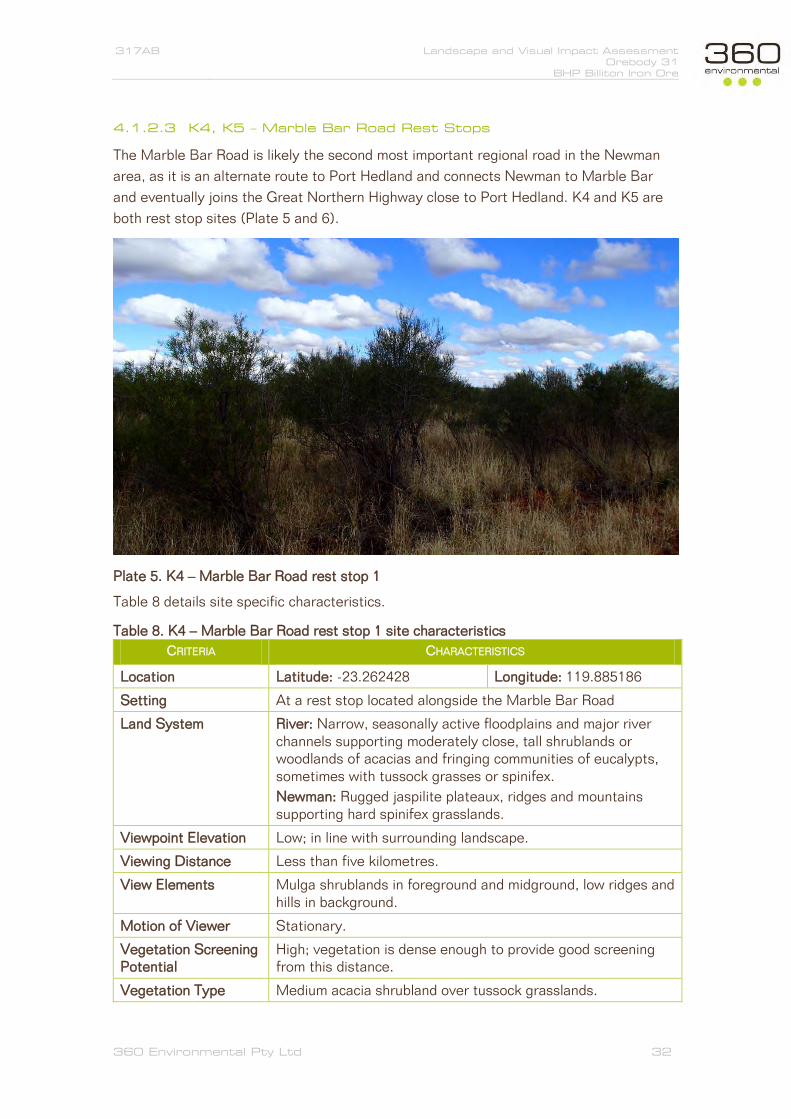
317AB Landscape and Visual Impact Assessment Orebody 31
BHP Billiton Iron Ore
360 Environmental Pty Ltd 32
4.1.2.3 K4, K5 – Marble Bar Road Rest Stops
The Marble Bar Road is likely the second most important regional road in the Newman
area, as it is an alternate route to Port Hedland and connects Newman to Marble Bar
and eventually joins the Great Northern Highway close to Port Hedland. K4 and K5 are
both rest stop sites (Plate 5 and 6).
Plate 5. K4 – Marble Bar Road rest stop 1
Table 8 details site specific characteristics.
Table 8. K4 – Marble Bar Road rest stop 1 site characteristics
CRITERIA CHARACTERISTICS
Location Latitude: -23.262428 Longitude: 119.885186
Setting At a rest stop located alongside the Marble Bar Road
Land System River: Narrow, seasonally active floodplains and major river channels supporting moderately close, tall shrublands or woodlands of acacias and fringing communities of eucalypts, sometimes with tussock grasses or spinifex.
Newman: Rugged jaspilite plateaux, ridges and mountains supporting hard spinifex grasslands.
Viewpoint Elevation Low; in line with surrounding landscape.
Viewing Distance Less than five kilometres.
View Elements Mulga shrublands in foreground and midground, low ridges and hills in background.
Motion of Viewer Stationary.
Vegetation Screening Potential
High; vegetation is dense enough to provide good screening from this distance.
Vegetation Type Medium acacia shrubland over tussock grasslands.

317AB Landscape and Visual Impact Assessment Orebody 31
BHP Billiton Iron Ore
360 Environmental Pty Ltd 33
CRITERIA CHARACTERISTICS
Land Use Transportation.
Accessibility High; rest stop is located along paved section of the road.
Usage High; rest stop is along a regionally important transport route.
Potential Visual Risk Low; distance to the project area and vegetation cover makes direct impacts from the proposal likely to be very low.
Valued Landscape Characteristics
Dense stands of vegetation.
Plate 6. K5 – Marble Bar Road rest stop 2
Table 9 details characteristics specific to this site.

317AB Landscape and Visual Impact Assessment Orebody 31
BHP Billiton Iron Ore
360 Environmental Pty Ltd 34
Table 9. K5 – Marble Bar Road rest stop 2 site characteristics
CRITERIA CHARACTERISTICS
Location Latitude: -23.177381 Longitude: 119.917134
Setting At a rest stop located alongside the Marble Bar Road
Land System River; Narrow, seasonally active floodplains and major river channels supporting moderately close, tall shrublands or woodlands of acacias and fringing communities of eucalypts, sometimes with tussock grasses or spinifex.
Newman; Rugged jaspilite plateaux, ridges and mountains supporting hard spinifex grasslands.
Viewpoint Elevation Low; in line with surrounding landscape.
Viewing Distance 5 – 10 km.
View Elements Mulga shrubs and hummock/tussocks, riparian vegetation in the mid-background.
Motion of Viewer Stationary / in motion.
Vegetation Screening Potential
Moderate-high; vegetation in some areas is scattered, but dense enough to provide screening from this distance.
Vegetation Type Scattered medium acacia shrubland over mixed buffel grass tussock and spinifex hummock grasslands.
Land Use Transportation.
Accessibility High; rest stop is located along paved section of the road.
Usage High; rest stop is along a regionally important transport route.
Potential Visual Risk Low; distance to the project area and vegetation cover makes direct impacts from the proposal likely to be very low.
Valued Landscape Characteristics
Riparian vegetation along creeklines.

317AB Landscape and Visual Impact Assessment Orebody 31
BHP Billiton Iron Ore
360 Environmental Pty Ltd 35
4.1.2.4 K6 – Kalgan Pool
Kalgan Pool, located along Kalgan Creek is arguably one of the most highly valued
tourist attraction in the Newman region, being the most easily accessed pool site in close
proximity to the town. Its high tourism, cultural and recreational value to the public was
the main driver for considering this site as key, despite its large distance from the
Project area and as such, was considered important enough to warrant consideration in
this assessment.
At present, Hamersley Iron, owned by the Rio Tinto group has approval to discharge
excess groundwater into the creek, approximately 2.3 km downstream from the pool site
(EPA 2013b).
Plate 7. K6 – Kalgan Pool
Note that the view presented in Plate 7 is of the actual pool itself, which is to the
northwest of the viewpoint surveyed. The OB31 Project area is located to the southeast
of the viewpoint, and will be used in the viewshed and photomontage analyses.

317AB Landscape and Visual Impact Assessment Orebody 31
BHP Billiton Iron Ore
360 Environmental Pty Ltd 36
Table 10. K6 – Kalgan Pool site characteristics
CRITERIA CHARACTERISTICS
Location Latitude: -23.188282 Longitude: 119.699356
Setting Viewpoint is located alongside a natural pools along Kalgan Creek.
Land System Newman: Rugged jaspilite plateaux, ridges and mountains supporting hard spinifex grasslands.
Viewpoint Elevation Low; set within a small gorge, therefore making the viewpoint lower than the surrounding landscape.
Viewing Distance In excess of 35 km.
View Elements Pool, riparian vegetation, rock face.
Motion of Viewer Stationary.
Vegetation Screening Potential
Moderate; stands of tall eucalypts can provide suitable screening, however it is not considered necessary for this site
Vegetation Type Scattered eucalypt riparian vegetation
Land Use Tourism, recreation.
Accessibility Moderate; access with a four wheel drive is relatively easy.
Usage Moderate; site is advertised in tourist maps.
Potential Visual Risk Low-negligible; the site is nestled within a creek bed surrounded by gorges.
Valued Landscape Characteristics
Views of the pool and ironstone walls.

317AB Landscape and Visual Impact Assessment Orebody 31
BHP Billiton Iron Ore
360 Environmental Pty Ltd 37
4.1.3 K7 Round Hill
Round Hill is a locally valued recreation spot used primarily for camping and hiking. It
offers 360o panoramic views of the Fortescue River Valley as well as of Opthalmia Ridge
(pictured). A portion of the site is also valued as an Aboriginal heritage site.
The site itself is fairly significant in relation to the surrounding landscape as it is the only
elevated point along the Fortescue River floodplain in the Newman region.
Plate 8. K7 – Round Hill
Panoramic 360o views can be seen from this site. The view shown here is that to the
northeast (Plate 8).
Characteristics of the site itself are detailed in Table 11.

317AB Landscape and Visual Impact Assessment Orebody 31
BHP Billiton Iron Ore
360 Environmental Pty Ltd 38
Table 11. K7 – Round Hill site characteristics
CRITERIA CHARACTERISTICS
Location Latitude: -23.44394 Longitude: 119.77057
Setting View from the north eastern slopes of Round Hill, looking to the north east.
Land System Washplain: Hardpan plains supporting groved mulga shrublands.
Divide: Gently undulating sandplains with minor dunes, supporting hard spinifex hummock grasslands with numerous shrubs.
River: Narrow, seasonally active floodplains and major river channels supporting moderately close, tall shrublands or woodlands of acacias and fringing communities of eucalypts, sometimes with tussock grasses or spinifex.
Newman: Rugged jaspilite plateaux, ridges and mountains supporting hard spinifex grasslands.
Viewpoint Elevation Elevated; the site is located in a highpoint relative to the surrounding landscape.
Viewing Distance In excess of 25 km.
View Elements Mulga shrublands on Fortescue River floodplain in the fore-mid ground and Opthalmia Range in the background.
Motion of Viewer Stationary, slow.
Vegetation Screening Potential
Low; elevated nature of the site reduces the effectiveness of vegetation to act as screens. Rocky soils results in low hummocks and scattered tall trees.
Vegetation Type Scattered eucalypts over scattered Triodia hummock grasses.
Land Use Recreation.
Accessibility Moderate; accessible by an unmarked albeit well used track off the Great Northern Highway.
Usage Moderate; signs of recent recreational use (4WD/Camping) were noted at the site during the field survey.
Potential Visual Risk Low; the OB31 Project area is located in excess of 25 km from the site. Some dust may be visible, but impacts may be minor.
Valued Landscape Characteristics
Panoramic and long distance views over the landscape.

317AB Landscape and Visual Impact Assessment Orebody 31
BHP Billiton Iron Ore
360 Environmental Pty Ltd 39
4.1.4 K8 – Great Northern Highway and Marble Bar Road
An eighth ‘viewpoint’ was also selected, consisting of 103 km of the Great Northern
Highway and Marble Bar Road, approximately 41 km south and 62 km north of Newman.
This site is not a ‘viewpoint’ at all, but rather a ‘viewline’ as the analysis was run on the
entire section of road, and the changes to the cumulative viewshed analysed. This was
done to better assess impacts to transportation networks as well as due to the relative
lack of sites in the vicinity of the OB31 Project. As it was not possible to obtain digital
photographs of the entire length of road, this ‘site’ will only be assessed quantitatively
through a viewshed analysis. The location of this section in relation to the Project area is
shown on Plate 9.
Plate 9. K8 – Great Northern Hwy and Marble Bar Road (aerial image: Landgate 2013)
General descriptions of landscape values along this section of road are presented in
Table 12.

317AB Landscape and Visual Impact Assessment Orebody 31
BHP Billiton Iron Ore
360 Environmental Pty Ltd 40
Table 12. K6 – Round Hill site characteristics
CRITERIA CHARACTERISTICS
Location Latitude: n/a Longitude: n/a
Setting A 103 km stretch of the Great Northern Highway and Marble Bar Road.
Land System River: Narrow, seasonally active floodplains and major river channels supporting moderately close, tall shrublands or woodlands of acacias and fringing communities of eucalypts, sometimes with tussock grasses or spinifex.
Newman: Rugged jaspilite plateaux, ridges and mountains supporting hard spinifex grasslands.
Viewpoint Elevation Low; in line with surrounding landscape, often running alongside creeklines and the Fortecue River floodplain, occasionally topping low ridges.
Viewing Distance 5 – 20 km.
View Elements Mulga shrubs and hummock/tussocks, riparian vegetation alongside a large central portion.
Motion of Viewer In motion; speeds ranging from 110 km/h to 60-80 km/h.
Vegetation Screening Potential
Moderate-high; vegetation in some areas is scattered, but dense enough to provide screening from this distance.
Vegetation Type Scattered medium acacia shrubland over mixed buffel grass tussock and spinifex hummock grasslands.
Land Use Transportation.
Accessibility High; most sections of this stretch of road is paved, and is at the most, 60 km from Newman.
Usage High; the Great Northern Highway is a nationally important transportation route while the Marble Bar Road is regionally important.
Potential Visual Risk Low; vegetation screening, high travel speeds, low elevation, large distance and the presence of Opthalmia Range on either side of the road sections closes to the project area results in low risk of overall impact.
Valued Landscape Characteristics
Riparian vegetation along creek-lines, occasional views of the landscape when topping low ridges.

317AB Landscape and Visual Impact Assessment Orebody 31
BHP Billiton Iron Ore
360 Environmental Pty Ltd 41
4.2 Visual Impact Assessment
4.2.1 Viewshed and Photomontage Analyses
Figures 9 to 15 illustrate the results of the viewshed and photomontage analysis. Figure
16 presents the results of a viewshed analysis conducted on sections of the Marble Bar
Road and the Great Northern Highway that were considered most at risk of impact.
Each viewshed presents the percentage change that falls into the four impact categories,
blocked by development, natural view created, pit view created or OSA view created.
The sum of these percentages produces the total impact to the viewshed.
4.2.2 Impacts to Landscape Character and Land Systems
To quantify impacts to landscape character, the disturbance footprint of the Project
(based on indicative disturbance areas provided by BHP Billiton Iron Ore) was compared
to current extents of the LCTs and Land Systems that the OB31 project falls into. This
enabled the estimation of percentage impacts to the landscape at both regional and local
levels. Table 13 details the findings of this.
Table 13. Impacts to LCTs and Land Systems
LANDCAPE CHARACTER TYPES
(LCT)
AREA WITHIN OB31
PROJECT (KM2)
CURRENT EXTENT
(KM2)*
PERCENTAGE
IMPACT
284 – Fortescue Valley 17.51 15,300 0.11%
258 – Hamersley Plateaux 23.04 44,450 0.05%
LAND SYTEM AREA WITHIN OB31
PROJECT (KM2)
CURRENT EXTENT
(KM2)†
PERCENTAGE
IMPACT
BGD – Boolgeeda System 16.86 7,748 0.22%
NEW – Newman System 19.92 14,580 0.14%
WSP – Washplain System 3.42 917 0.37%
MCK – McKay System 0.35 4,202 0.01%
* Sourced from Tille 2006 † Sourced from Van Vreeswyk et al. 2004

!?
20 km
10 km
5 km
50 km
K 1
COPYRIGHT © 2013: THIS DO CUM ENT IS AND SHALL REM AIN THE PROPERTY OF 360 ENVIRONMENTAL. T HIS DOCUMENT M AY ONLY BE USED FOR T HE PURPOSE F OR WHICH IT WAS CO MM ISSIONED AND IN ACCORDANCE WITH T HE TERM S OF ENGAGEMENT F OR THE COM MISSIO N. 360 ENVIRO NM ENTAL DOES NOT HO LD ANY RESPONSIBILIT Y FOR T HE MISUSE OF T HIS DOCUMENT.
N
PROJECT NUMBER
Figure 9 - K1 Radio Tower Hill, Newman
Post Development Photomontage
Pre Development PhotomontageViewshed
0 2 4 6 8 101Kilometers
DRAWNJJ
CHECKEDFJ APPROVEDFJ
Legend317
DATE24-Mar-2014
!? Key ViewpointSite Layout
OSAPitInfrastructure
Field of ViewViewshed Analysis Results
No Change - Always Not VisibleNo Change - Always Visible
Pit View CreatedOSA View CreatedNatural View CreatedView Blocked by Development
A
A
10 Bermondsey St,West Leedervi lle , WA9388 8360
The OB31 Project is locatedbeween Wheelara and
Shovellana Hills
Site No & NameLocation (GDA94)View Direction
Land System
Description of View
Vegetation Screening Capability
% Viewshed blocked out by Development 0.00% Site Significance Recreation
% Pit views created 0.00% Visitor Traffic High% OSA views created 0.00% Accessibility High% Natural Landscape views created 0.00% Overal Impact Low - Negligible
Moderate - Low; vegetation in certain areas are capable of acting as effective screens, however the site is elevated above the landscape, minimising screen effectiveness
Viewshed Statistics Site Visual Impact
Viewpoint CharacteristicsK1 - Radio Tower Hill, Newman119.725789, -23.363012ENewman - Rugged jaspilite plateaux, ridges and mountains supporting hard spinifex grasslands.Elimunna - Stony plains on basalt supporting snakewood and mulga shrublands with sparse tussock grassesPanoramic views of the surroundings, including the OB25 Project (A) and the distant Opthalmia Ridge. On a clear day, the Jimblebar mine is faintly visible.
B
CB C
Wheelara Hill(Jimblebar)Orebody 25
ShovellanaHill (OB18)

!?
20 km
10 km
5 km
K 2
COPYRIGHT © 2013: THIS DO CUM ENT IS AND SHALL REM AIN THE PROPERTY OF 360 ENVIRONMENTAL. T HIS DOCUMENT M AY ONLY BE USED FOR T HE PURPOSE F OR WHICH IT WAS CO MM ISSIONED AND IN ACCORDANCE WITH T HE TERM S OF ENGAGEMENT F OR THE COM MISSIO N. 360 ENVIRO NM ENTAL DOES NOT HO LD ANY RESPONSIBILIT Y FOR T HE MISUSE OF T HIS DOCUMENT.
N
PROJECT NUMBER
Figure 10 - K2 Opthalmia Dam Picnic Area, Newman
Post Development Photomontage
Pre Development PhotomontageViewshed
0 2 4 6 81Kilometers
DRAWNJJ
CHECKEDFJ APPROVEDFJ
Legend317
DATE24-Mar-2014
!? Key ViewpointSite Layout
OSAPitInfrastructure
Field of ViewViewshed Analysis Results
No Change - Always Not VisibleNo Change - Always Visible
Pit View CreatedOSA View CreatedNatural View CreatedView Blocked by Development
A
Ridgeline not visible in reality. Coarse terrain resolution causes a
'smoothing' over the dam wall, reducing its height
A
10 Bermondsey St,West Leedervi lle , WA9388 8360
The OB31 Project is locatedbehind Opthalmia Ridge, not
visible from this site due to thedam walls
Site No & NameLocation (GDA94)View Direction
Land System
Description of ViewVegetation Screening Capability
% Viewshed blocked out by Development 0.00% Site Significance Recreation
% Pit views created 0.00% Visitor Traffic High% OSA views created 0.00% Accessibility High% Natural Landscape views created 0.00% Overal Impact Low - Negligible
Moderate; vegetation in certain areas are capable of acting as effective screens.Viewshed Statistics Site Visual Impact
Viewpoint CharacteristicsK2 - Opthalmia Dam Picnic Area119.877737, -23.339803ENewman - Rugged jaspilite plateaux, ridges and mountains supporting hard spinifex grasslands.McKay - Hills, ridges, plateaux remnants and breakaways of meta sedimentary and sedimentary rocks supporting hard spinifex grasslands with acacias and occasional eucalypts.The site is located along the northwestern banks of Opthalmia dam and is used as a picnic area. The site features gas barbeque, toilet and picnic facilities.

!?
20 km
10 km
5 km
COPYRIGHT © 2013: THIS DO CUM ENT IS AND SHALL REM AIN THE PROPERTY OF 360 ENVIRONMENTAL. T HIS DOCUMENT M AY ONLY BE USED FOR T HE PURPOSE F OR WHICH IT WAS CO MM ISSIONED AND IN ACCORDANCE WITH T HE TERM S OF ENGAGEMENT F OR THE COM MISSIO N. 360 ENVIRO NM ENTAL DOES NOT HO LD ANY RESPONSIBILIT Y FOR T HE MISUSE OF T HIS DOCUMENT.
N
PROJECT NUMBER
Figure X - K3 Opthalmia Dam Wall
Post Development Photomontage
Pre Development PhotomontageViewshed
0 2 4 6 81Kilometers
DRAWNJJ
CHECKEDFJ APPROVEDFJ
Legend317
DATE24-Mar-2014
!? Key ViewpointSite Layout
OSAPitInfrastructure
Field of ViewViewshed Analysis Results
No Change - Always Not VisibleNo Change - Always Visible
Pit View CreatedOSA View CreatedNatural View CreatedView Blocked by Development
A
A
10 Bermondsey St,West Leedervi lle , WA9388 8360
B
B
The OB31 development is locatedbehind the low ridgeline. The OB18 operation is directly on the lee side
of the hill (Shovellana)Wheelara Hill is visible. TheJimblebar operation is also
faintly visible
Site No & NameLocation (GDA94)View Direction
Land System
Description of View
Vegetation Screening Capability
% Viewshed blocked out by Development 0.00% Site Significance Recreation
% Pit views created 0.00% Visitor Traffic High% OSA views created 0.00% Accessibility High% Natural Landscape views created 0.00% Overal Impact Low - Negligible
Moderate - Low: Being a floodplain, stands of tall eucalypts do provide spotty screening, however elevation of viewpoint minimises their effectiveness.
Viewshed Statistics Site Visual Impact
Viewpoint CharacteristicsK3 - Opthalmia Dam Wall119.879066, -23.339684ERiver - Narrow, seasonally active floodplains and major river channels supporting moderately close, tall shrublands or woodlands of acacias and fringing communities of eucalypts.Newman - Rugged jaspilite plateaux, ridges and mountains supporting hard spinifex grasslandsA lookout point close to the Opthalmia Dam picnic area. Panorami views over the Fortescue River floodplain and Opthalmia Ridge can be seen from this site.

!?
20 km
10 km
5 km
COPYRIGHT © 2013: THIS DO CUM ENT IS AND SHALL REM AIN THE PROPERTY OF 360 ENVIRONMENTAL. T HIS DOCUMENT M AY ONLY BE USED FOR T HE PURPOSE F OR WHICH IT WAS CO MM ISSIONED AND IN ACCORDANCE WITH T HE TERM S OF ENGAGEMENT F OR THE COM MISSIO N. 360 ENVIRO NM ENTAL DOES NOT HO LD ANY RESPONSIBILIT Y FOR T HE MISUSE OF T HIS DOCUMENT.
N
PROJECT NUMBER
Figure 12 - K4 Marble Bar Road Rest Stop 1
Post Development Photomontage
Pre Development PhotomontageViewshed
0 2 4 6 81Kilometers
DRAWNJJ
CHECKEDFJ APPROVEDFJ
Legend317
DATE24-Mar-2014
!? Key ViewpointSite Layout
OSAPitInfrastructure
Field of ViewViewshed Analysis Results
No Change - Always Not VisibleNo Change - Always Visible
Pit View CreatedOSA View CreatedNatural View CreatedView Blocked by Development
Ridgeline in the distance and vegetationalong the Fortescue River screens all
views of the Project area
A
10 Bermondsey St,West Leedervi lle , WA9388 8360
A
Dense Mulga shrublands and creekvegetation further in provides high
levels of vegetation screening
Site No & NameLocation (GDA94)View Direction
Land System
Description of View
Vegetation Screening Capability
% Viewshed blocked out by Development 0.00% Site Significance Transport
% Pit views created 0.00% Visitor Traffic Moderate% OSA views created 0.00% Accessibility Moderate% Natural Landscape views created 0.00% Overal Impact Low - Negligible
High: vegetation is dense enough to provide good screening from this distance
Viewshed Statistics Site Visual Impact
Viewpoint CharacteristicsK4 - Marble Bar Road Rest Stop 1119.885186, -23.262428ERiver - Narrow, seasonally active floodplains and major river channels supporting moderately close, tall shrublands or woodlands of acacias and fringing communities of eucalypts.Newman - Rugged jaspilite plateaux, ridges and mountains supporting hard spinifex grasslandsView from along the Marble Bar Road, within the Fortescue River floodplain. Mulga shrublands in the foreground with Opthalmia Ridgeland in the back.

!?
20 km10 km
5 km
COPYRIGHT © 2013: THIS DO CUM ENT IS AND SHALL REM AIN THE PROPERTY OF 360 ENVIRONMENTAL. T HIS DOCUMENT M AY ONLY BE USED FOR T HE PURPOSE F OR WHICH IT WAS CO MM ISSIONED AND IN ACCORDANCE WITH T HE TERM S OF ENGAGEMENT F OR THE COM MISSIO N. 360 ENVIRO NM ENTAL DOES NOT HO LD ANY RESPONSIBILIT Y FOR T HE MISUSE OF T HIS DOCUMENT.
N
PROJECT NUMBER
Figure 13 - K5 Marble Bar Road Rest Stop 2
Post Development Photomontage
Pre Development PhotomontageViewshed
0 2 4 6 81Kilometers
DRAWNJJ
CHECKEDFJ APPROVEDFJ
Legend317
DATE24-Mar-2014
!? Key ViewpointSite Layout
OSAPitInfrastructure
Field of ViewViewshed Analysis Results
No Change - Always Not VisibleNo Change - Always Visible
Pit View CreatedOSA View CreatedNatural View CreatedView Blocked by Development
A
10 Bermondsey St,West Leedervi lle , WA9388 8360
A
Dense Mulga shrublands and creekvegetation further in provides high
levels of vegetation screening
Site No & NameLocation (GDA94)View Direction
Land System
Description of View
Vegetation Screening Capability
% Viewshed blocked out by Development 0.00% Site Significance Transport
% Pit views created 0.00% Visitor Traffic Moderate% OSA views created 0.00% Accessibility Moderate% Natural Landscape views created 0.00% Overal Impact Low - Negligible
High: vegetation is dense enough to provide good screening from this distance
Viewshed Statistics Site Visual Impact
Viewpoint CharacteristicsK5 - Marble Bar Road Rest Stop 2119.917134, -23.177381SERiver - Narrow, seasonally active floodplains and major river channels supporting moderately close, tall shrublands or woodlands of acacias and fringing communities of eucalypts.Newman - Rugged jaspilite plateaux, ridges and mountains supporting hard spinifex grasslandsView from along the Marble Bar Road, within the Fortescue River floodplain. Mulga shrublands in the foreground with Opthalmia Ridgeland in the back.

!?
20 km
10 km
50 km
5 km
COPYRIGHT © 2013: THIS DO CUM ENT IS AND SHALL REM AIN THE PROPERTY OF 360 ENVIRONMENTAL. T HIS DOCUMENT M AY ONLY BE USED FOR T HE PURPOSE F OR WHICH IT WAS CO MM ISSIONED AND IN ACCORDANCE WITH T HE TERM S OF ENGAGEMENT F OR THE COM MISSIO N. 360 ENVIRO NM ENTAL DOES NOT HO LD ANY RESPONSIBILIT Y FOR T HE MISUSE OF T HIS DOCUMENT.
N
PROJECT NUMBER
Figure 14 - K6 Kalgan Pool
Post Development Photomontage
Pre Development PhotomontageViewshed
0 2 4 6 81Kilometers
DRAWNJJ
CHECKEDFJ APPROVEDFJ
Legend317
DATE24-Mar-2014
!? Key ViewpointSite Layout
OSAPitInfrastructure
Field of ViewViewshed Analysis Results
No Change - Always Not VisibleNo Change - Always Visible
Pit View CreatedOSA View CreatedNatural View CreatedView Blocked by Development
10 Bermondsey St,West Leedervi lle , WA9388 8360
Project Area is located in this direction
Site No & NameLocation (GDA94)View Direction
Land System
Description of View
Vegetation Screening Capability
% Viewshed blocked out by Development 0.00% Site Significance Tourism, Recreation
% Pit views created 0.00% Visitor Traffic Moderate% OSA views created 0.00% Accessibility Moderate% Natural Landscape views created 0.00% Overal Impact Negligible
High: vegetation is dense enough to provide good screening from this distance. Vegetation screening is not considered necessary due to the sites location within the gorge
Viewshed Statistics Site Visual Impact
Viewpoint CharacteristicsK6 - Kalgan Pool119.699356 , -23.188282ESENewman - Rugged jaspilite plateaux, ridges and mountains supporting hard spinifex grasslands
View of the acess road from the Kalgan Pool Viewpoint. The project area is in this direction. The pool itself is located opposite this view.
The terrain surrounding the site results in a very small
viewshed

!?
20 km
10 km
5 km
K7
COPYRIGHT © 2013: THIS DO CUM ENT IS AND SHALL REM AIN THE PROPERTY OF 360 ENVIRONMENTAL. T HIS DOCUMENT M AY ONLY BE USED FOR T HE PURPOSE F OR WHICH IT WAS CO MM ISSIONED AND IN ACCORDANCE WITH T HE TERM S OF ENGAGEMENT F OR THE COM MISSIO N. 360 ENVIRO NM ENTAL DOES NOT HO LD ANY RESPONSIBILIT Y FOR T HE MISUSE OF T HIS DOCUMENT.
N
PROJECT NUMBER
Figure 15 - K7 Round Hill
Post Development Photomontage
Pre Development PhotomontageViewshed
0 2 4 6 81Kilometers
DRAWNJJ
CHECKEDFJ APPROVEDFJ
Legend317
DATE24-Mar-2014
!? Key ViewpointSite Layout
OSAPitInfrastructure
Field of ViewViewshed Analysis Results
No Change - Always Not VisibleNo Change - Always Visible
Pit View CreatedOSA View CreatedNatural View CreatedView Blocked by Development
A
A
10 Bermondsey St,West Leedervi lle , WA9388 8360
B B
The OB31 development is locatedin the gap between Shovellana (A)
and Wheelara (B) HillsWheelara Hill is visible. TheJimblebar operation is also
faintly visible
Site No & NameLocation (GDA94)View Direction
Land System
Description of View
Vegetation Screening Capability
% Viewshed blocked out by Development 0.00% Site Significance Recreation
% Pit views created 0.00% Visitor Traffic Moderate% OSA views created 1.11% Accessibility Moderate% Natural Landscape views created 0.00% Overal Impact Low - Negligible
Low: Elevated nature of the viewpoint and scattered vegetation results in limted screening ability
Viewshed Statistics Site Visual Impact
Viewpoint CharacteristicsK7 - Round Hill119.77057, -23.44394NEDivide - Gently undulating sandplains with minor dunes, supporting hard spinifex hummock grasslands with numerous shrubs.River - Narrow, seasonally active floodplains and major river channels supporting moderately close, tall shrublands or woodlands of acacias and fringing communities of eucalypts.A small elevated hill in the Fortescue River floodplain. Panoramic views across the landscape.
Some OSA areas aretheoretically visible
C
C

CREATED APPROVED REVISIONCHECKED
Coord inate System: GDA 1994 MGA Zone 50
OREBODY 31
THEO
RETIC
ALLY
IMPA
CTED
ARE
AS
GREA
T NO
RTHE
RN H
WY
MARBL E BA R RD
760000
760000
780000
780000
800000
800000
820000
820000
840000
840000
7400
000
7400
000
7420
000
7420
000
7440
000
7440
000
7460
000
7460
000Ê
0 4 8 12 162
Kilometers
LegendGreat Northern HwyMarble Bar Rd
Orebody 31 Project AreasOSAPitConveyor and Haul Roads
Viewshed Analysis ResultsNo Change Always Not VisibleNo Change Always VisibleBlocked due to DevelopmentOSA View CreatedPit View Created
!(
!(
!(!(
!(!(
!(
!(
!(
!(
!(
!(!(NEWMAN
TALAWANA
ROY HILL
JIGGALONG
MARILLANA
MUNDIWINDI
LOFTY RANGE
MOUNT NEWMAN
BULLOO DOWNS
BALFOUR DOWNS
LOCALITY MAP
DATEDRAWING ID
JJ FJ TS
- NOTE THAT POSITION ERRORS CA N BE >5M IN SOME AREAS- LOCALITY MAP SOURCED FROM LANDGATE 2006- LANDSCAPE CHARACTER TYPES ADAPTED FROM TILLE 2006- ALL OTHER DATA SOURCE D FROM B HP BILLITON IRON ORE- AERIAL PHOTOGRAPHY S OURCED FROM LANDSAT7 (© Wester n Australian Land In formation Authority 2013)
22/05/2014
K:\Projects\4.0 RES\317 OB31 LVIA\Figures\Report Figures
0
HORIZONTAL DATUM AND PR OJEC TION317
BHP Billiton Iron OreOrebody 31Landscape and Visual ImpactAssessment (LVIA)
COPYRIGHT: THIS DOCUMENT IS AND SHALL REMAIN THE PROPERTY OF 360 ENVIRONMENTAL. THIS DOCUMENT MAY ONLY BE USED FOR THE PURPOSE FOR WHICH IT WAS COMMISSIONED AND IN ACCORDANCE WITH THE TERMS OF ENGAGEMENT FOR THE COMMISSION. 360 ENVIRONMENTAL DOES NOT HOLD ANY RESPONSIBILITY FOR THE MISUSE OF THIS DOCUMENT.
@ A41:450,000
Figure 16 - Great NorthernHwy and Marble Bar Rd
a 10 B erm onds ey S t, Wes t Leederv ille, 6007 WAt (08) 9388 8360f (08) 9381 2360w www.360environmental .com.au
Impact Type % Change% Viewshed blocked out by development 0.31% Pit views created 0.00% OSA views created 0.34% Natural landscape views created 0

317AB Landscape and Visual Impact Assessment Orebody 31
BHP Billiton Iron Ore
360 Environmental Pty Ltd 50
5 Discussion
5.1 Direct Impacts on Visual Amenity
On a regional scale the direct impact of the Project on landscape character was found to
be very small. Direct impact as a result of clearing activities for the development is
estimated to affect only 0.11% and 0.05% of the total area of the Hamersley and
Fortescue Valley LCTs respectively (Table 13). On a more localised levels, direct impacts
to land systems were also relatively low. It is estimated that 0.22% of the Boolgeeda,
0.14% of the Newman, 0.37% of the McKay and 0.29% of the Washlplain land systems
will be affected (Table 13).
The findings of the viewshed and photomontages analyses for each sensitive receptor
site are listed below.
5.1.1 K1 – Radio Tower Hill
The viewshed analysis showed that the OB31 development area was not visible, a finding
supported by the on-site survey (Figure 9). Impacts to this site are predominantly from
other operations in proximity of it, such as the Mount Whaleback, OB25 and OB35
projects. In addition to this, the site is located in excess of 30 km from the Project area.
It is likely that the site will not be impacted by the OB31 development.
5.1.2 K2, K3 – Opthalmia Dam
Impacts to the picnic site (K2) are likely to be negligible due to the small size and
restricted nature of its viewshed (Figure 10). The vast majority of the Project area is also
located in excess of 30 km from this site.
There may however be some minor indirect impacts to the dam wall viewpoint (K3), likely
to be in the form of dust and noise during blasting events. As ore will undergo further
processing at OB18 and potentially Jimblebar, dust plumes from these areas may be
visible.
OB3 is still located in over 30 km from the Opthalmia dam viewpoints which is just
beyond the maximum view distance where features are easily recognisable by the naked
eye (~25 km).
It is therefore considered that impacts to landscape character and amenity at Opthalmia
Dam are likely to be minor, if not negligible.
5.1.3 K4, K5 – Marble Bar Road
The first rest stop on the Marble Bar Road (closest to Newman) is situated in a section
of road that runs on the western side of the Fortescue River, bounded by Opthalmia
Range to the east and west. This results in a geographically restricted viewshed even

317AB Landscape and Visual Impact Assessment Orebody 31
BHP Billiton Iron Ore
360 Environmental Pty Ltd 51
before the effects of vegetation is considered. The proximity of the site to a major river
has resulted in dense, closed eucalypt woodlands, surrounded by mulga shrublands.
These provide a level of screening that is very high (Figure 12).
The second rest stop approximately 10 km north of Opthalmia Range is still located
along the Fortescue River, which results in high levels of vegetation screening.
5.1.4 K6 – Kalgan Pool
Impacts to Kalgan pool and the creek are considered negligible due to the large distance
from the OB31 Project area. The pool maybe affected projects upstream from it (Hope
Downs 4).
5.1.5 K7 - Round Hill
Round Hill was the only site that may see any direct impacts, as suggested by the
viewshed analysis (Figure 15). In total, it is estimated that approximately 1.1% of the
viewshed from this viewpoint will be directly altered by the development (OSA). While
this figure is small, in reality, it is expected that direct impacts to this site will likely be
lower due to the great distance (in excess of 40 km) between the viewpoint and the
development area.
5.1.6 K8 - Regional Road Ways – Marble Bar Road and Great
Northern Highway
The viewshed analysis conducted on the sections of the Great Northern Highway and
Marble Bar Road that are closest to the development shows that the Project is
theoretically visible from several areas along the road. It is expected however that
impacts are relatively minor considering the extent of surrounding developments, the
elevation at most sections of these roads (a large portion runs along the Fortescue River
floodplain, which is low lying and surrounded by tall vegetation) and the large distance
between the road and the Project area (at its closest point, the road is still approximately
20 km from the Project area).
The analysis suggested that approximately 0.65% of the cumulative viewshed from the
103 km section of road will be affected by the development.
5.2 Cumulative Impacts on Visual Impact
5.2.1 Third Party Developments
No known third party developments are currently anticipated to be active during the life
of OB31. Leases directly north of the Project area is currently held by Rio Tinto for
exploration purposes (Department of Mines and Petroleum [DMP] 2014).

317AB Landscape and Visual Impact Assessment Orebody 31
BHP Billiton Iron Ore
360 Environmental Pty Ltd 52
6 Conclusion
6.1 Summary of Impacts
Impacts to landscape and visual amenity from the OB31 Project have been demonstrated
as being minor in relation to existing impacts, due to its unique topographical setting. In
many cases, sites with high levels of public interest and use, such as Opthalmia Dam, the
Radio Tower Hill Lookout (and the Newman Townsite) showed little to no alterations in
their viewsheds as a result of the development.
Furthermore, desktop and field assessments of the areas surrounding OB31 failed to
identify any sites of significance that may be directly impacted by the project.
Cumulative impacts, likely manifested as increased aerial dust concentrations may be
expected due to the close clustering of neighbouring projects (the Jimblebar operation).
However, as the Newman area on average experiences westerly winds, it is possible that
dust may on average move eastwards of the site, away from the town and major roads.
As ore from the OB31 project will undergo secondary processing through facilities
located at OB18 and possibly Jimblebar, dust impacts from TLO and the OHPs at these
sites may result in impacts to amenity from sensitive receptor sites in the Newman area.
The viewshed analyses suggested that at its highest, some areas of the OSAs will be
visible from high points in the region such as Radio Tower and Round Hills. However the
large distance (in excess of 20-25 km) will likely result in low visibility and are unlikely to
cause noticeable impacts on landscape character and amenity at these sites.
Similarly, the viewshed of the Great Northern Highway and Marble Bar Road sections
(K8) showed that the OB31 development is theoretically visible from some areas.
However, due to the roads relative elevation, distance from the development and the
extent of other developments around OB31, it is unlikely that landscape values
experienced through the use of these major transport routes will be affected by OB31. In
addition to this, the speed of travel along these roads will result in scattered potential
views of the development rather than a consistent view.

317AB Landscape and Visual Impact Assessment Orebody 31
BHP Billiton Iron Ore
360 Environmental Pty Ltd 53
7 Limitations
This report is produced strictly in accordance with the scope of services set out in the contract or
otherwise agreed in accordance with the contract. 360 Environmental makes no representations
or warranties in relation to the nature and quality of soil and water other than the visual
observation and analytical data in this report.
In the preparation of this report, 360 Environmental has relied upon documents, information, data
and analyses (“client’s information”) provided by the client and other individuals and entities. In
most cases where client’s information has been relied upon, such reliance has been indicated in
this report. Unless expressly set out in this report, 360 Environmental has not verified that the
client’s information is accurate, exhaustive or current and the validity and accuracy of any aspect
of the report including, or based upon, any part of the client’s information is contingent upon the
accuracy, exhaustiveness and currency of the client’s information. 360 Environmental shall not be
liable to the client or any other person in connection with any invalid or inaccurate aspect of this
report where that invalidity or inaccuracy arose because the client’s information was not accurate,
exhaustive and current or arose because of any information or condition that was concealed,
withheld, misrepresented, or otherwise not fully disclosed or available to 360 Environmental.
Aspects of this report, including the opinions, conclusions and recommendations it contains, are
based on the results of the investigation, sampling and testing set out in the contract and
otherwise in accordance with normal practices and standards. The investigation, sampling and
testing are designed to produce results that represent a reasonable interpretation of the general
conditions of the site that is the subject of this report. However, due to the characteristics of the
site, including natural variations in site conditions, the results of the investigation, sampling and
testing may not accurately represent the actual state of the whole site at all points.
It is important to recognise that site conditions, including the extent and concentration of
contaminants, can change with time. This is particularly relevant if this report, including the data,
opinions, conclusions and recommendations it contains, are to be used a considerable time after it
was prepared. In these circumstances, further investigation of the site may be necessary.
Subject to the terms of the contract between the Client and 360 Environmental Pty Ltd, copying,
reproducing, disclosing or disseminating parts of this report is prohibited (except to the extent
required by law) unless the report is produced in its entirety including this page, without the prior
written consent of 360 Environmental Pty Ltd.
317AB Landscape and Visual Impact Assessment Orebody 31
BHP Billiton Iron Ore
360 Environmental Pty Ltd 54
8 References
360 Environmental/GHD in prep, Pilbara Expansion Strategic Environmental
Assessment – Landscape and Visual Impact Assessment, unpublished draft report
prepared for BHP Billiton Iron Ore by 360 Environmental Pty Ltd.
360 Environmental/GHD 2013, South Flank Visual Impact Assessment – Landscape
and Visual Impact Assessment, unpublished report prepared for BHP Billiton Iron
Ore by 360 Environmental Pty Ltd.
BHP Billiton Iron Ore 2012, Manual – Life of Mine Plan – Overburden Storage Area
Design, Iron Ore Controlled Document. BHP Billiton.
BHP Billiton Iron Ore 2013, BHP Billiton Iron Ore Pilbara Expansion – Strategic Proposal
Environmental Scoping Document. Available at:
http://www.bhpbilliton.com/home/aboutus/regulatory/Documents/_ironore/weste
rnaustralianironore/130808_ironore_waio_BHPBillitonIronOrePilbaraExpansionEnviro
nmentalScopingDocument.pdfs
Department of Mines and Petroleum (DMP) (2011), Guidelines for Preparing Mine
Closure Plans, Government of Western Australia.
Department of Mines and Petroleum (DMP) (2011), Tenements, GIS Dataset,
Government of Western Australia.
Department of Sustainability, Environment, Water, Population and Communities
(DSEWPaC) 2012, Guidance Note 7 – Definition of ‘Environment’ under section 528
of the EPBC Act, Commonwealth of Australia.
Environmental Protection Authority (EPA) 2002, Position Statement No. 5 –
Environmental Protection and Sustainability of the Rangelands in Western Australia.
Available at: http://www.epa.wa.gov.au/docs/1516_PS502.pdf
Environmental Protection Authority (EPA) 2013a, Environmental Assessment Guideline
for Environmental factors and objectives, Government of Western Australia.
Environmental Protection Authority (EPA) 2013b, Ministerial Statement 854 - Statement
that a proposal may be implemented (pursuant to the provisions of the
Environmental Protection Act 1986), Attachment 3, Government of Western
Australia.
Ludwig, J. Tongway, D. Freudenberger, D. Noble, J. Hodgkinson, K. 1996, Landscape
Ecology Function and Management: Principles from Australia’s Rangelands, CSIRO
Australia.
Office of the Environmental Protection Authority (OEPA) (2010), Guide to EIA
Environmental Principles, Factors and Objectives, Government of Western Australia.

317AB Landscape and Visual Impact Assessment Orebody 31
BHP Billiton Iron Ore
360 Environmental Pty Ltd 55
The Landscape Institute and the Institute of Environmental Management and
Assessment (The Landscape Institute) 2002, Guidelines for Landscape and Visual
Impact Asssessment, Second Edition, Routledge, Oxon, United Kingdom.
Tille, P. 2006, Soil-landscapes of Western Australia’s Rangelands and Arid Interior,
Department of Agriculture and Food, Government of Western Australia.
Van Vreeswyk, A.M.E Payne, A.L. Leighton, K.A. & Hennig, P 2004, An inventory and
condition survey of the Pilbara region, Western Australia. Technical Bulletin No. 92,
Department of Agriculture, Government of Western Australia.
Western Australian Planning Commission (WAPC) 2003, State Planning Policy 2
Environment and Natural Resources, Western Australian Planning Commission,
Department of Planning and Infrastructure, Government of Western Australia.
Western Australian Planning Commission (WAPC) 2007, Visual Landscape Planning
Western Australia – a manual for evaluation, assessment, siting and design,
Western Australian Planning Commission, Department of Planning and
Infrastructure, Government of Western Australia.
Western Australian Planning Commission (WAPC) 2012, Pilbara planning and
infrastructure framework, Western Australian Planning Commission, Department of
Planning and Infrastructure, Government of Western Australia.

317AB Landscape and Visual Impact Assessment Orebody 31
BHP Billiton Iron Ore
360 Environmental Pty Ltd 56
APPENDIX A
Other Sites Considered

317AB Landscape and Visual Impact Assessment Orebody 31
BHP Billiton Iron Ore
360 Environmental Pty Ltd 57
Site 5 - Trugallenden Pool (pool not found)
CRITERIA CHARACTERISTICS
Location Latitude: -23.31089 Longitude: 119.867665
Setting Within the Fortescue River creek bed. The pool itself was not located.
Land System River; Narrow, seasonally active floodplains and major river channels supporting moderately close, tall shrublands or woodlands of acacias and fringing communities of eucalypts, sometimes with tussock grasses or spinifex.
Viewpoint Elevation Low; the site is located in a lowpoint (creekbed) in the landscape.
Viewing Distance <1 km.
View Elements Tall riparian vegetation in the mid/foreground, Opthalmia Range in the Background.
Motion of Viewer Stationary.
Vegetation Screening Potential
High.
Vegetation Type Tall eucalypts over annual grasses.
Land Use Recreation; the poolsite itself is marked on tourist maps.
Accessibility High; the site is directly adjacent to the Great Northern Highway, in close proximity to Newman.
Usage Moderate; the proximity to Newman and presence on tourist maps indicate some level of use.
Potential Visual Risk Low; the site is located some distance from the OB31 Project
Valued Landscape Characteristics
Riparian vegetation, pool (not located).

317AB Landscape and Visual Impact Assessment Orebody 31
BHP Billiton Iron Ore
360 Environmental Pty Ltd 58
Site 6 - Inawally Pool
CRITERIA CHARACTERISTICS
Location Latitude: -23.365037 Longitude: 120.193748
Setting On the banks of Jimblebar Creek at Inawally Pool
Land System River; Narrow, seasonally active floodplains and major river channels supporting moderately close, tall shrublands or woodlands of acacias and fringing communities of eucalypts, sometimes with tussock grasses or spinifex.
Viewpoint Elevation Low; the site is located in a lowpoint (creekbed) in the landscape.
Viewing Distance <1km.
View Elements Pool in the fore and mid ground and riparian vegetation in the mid and background.
Motion of Viewer Stationary.
Vegetation Screening Potential
Medium-High.
Vegetation Type Eucalypts lining the side of the creek.
Land Use Pastoral, Mining (exploration).
Accessibility Low; the site is accessible from the south via restricted access roads on from the North along unmarked and difficult 4WD tracks.
Usage Low; no recent evidence of use was noted.
Potential Visual Risk High; the OB31 Project is located to the left site of the frame.
Valued Landscape Characteristics
Pool, flora and fauna values.

317AB Landscape and Visual Impact Assessment Orebody 31
BHP Billiton Iron Ore
360 Environmental Pty Ltd 59
Site 11 - Jinerabar Pool (pool not found)
CRITERIA CHARACTERISTICS
Location Latitude: -22.964866 Longitude: 120.270888
Setting Along the access road to Jinerabar Pool (pool site was not located).
Land System River; Narrow, seasonally active floodplains and major river channels supporting moderately close, tall shrublands or woodlands of acacias and fringing communities of eucalypts, sometimes with tussock grasses or spinifex.
Viewpoint Elevation Lowl the site is located alongside a creekbed.
Viewing Distance <1 km.
View Elements Riparian vegetation in foreground, pool site likely dominates the site (if located).
Motion of Viewer Stationary.
Vegetation Screening Potential
High; riparian vegetation is composed of tall eucalypt woodlands and acacia shrubland.
Vegetation Type Eucalypt woodland over acacia shrubland.
Land Use Pastoral.
Accessibility Low; access is a 30 km unmarked 4X4 track.
Usage Low; track has been moderately used, however the site is unmarked on most maps.
Potential Visual Risk Low.
Valued Landscape Characteristics
Creek line and pool.

317AB Landscape and Visual Impact Assessment Orebody 31
BHP Billiton Iron Ore
360 Environmental Pty Ltd 60
PAGE INTENTIONALLY LEFT BLANK