Land north of Baldock Road, Royston, Hertfordshire...pro-forma sheets. Trench locations, plans and...
37
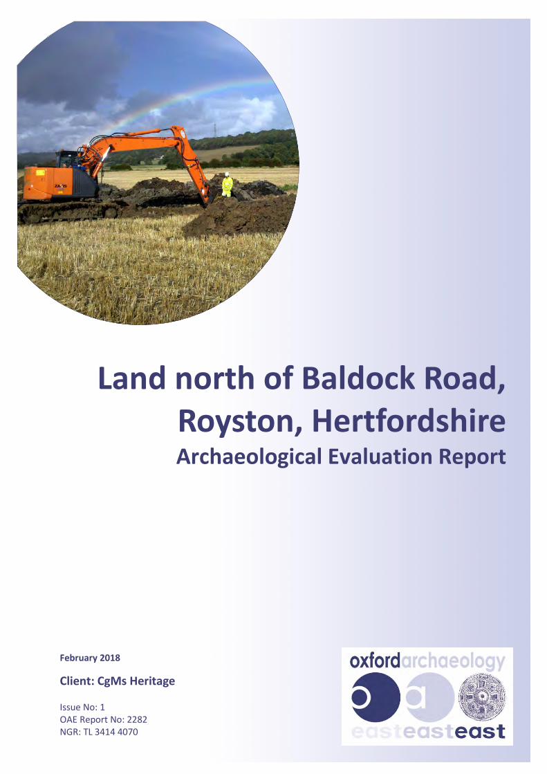
Land north of Baldock Road, Royston, Hertfordshire Archaeological Evaluation Report February 2018 Client: CgMs Heritage Issue No: 1 OAE Report No: 2282 NGR: TL 3414 4070
Transcript of Land north of Baldock Road, Royston, Hertfordshire...pro-forma sheets. Trench locations, plans and...
Land north of Baldock Road, Royston, Hertfordshire Archaeological Evaluation Report
February 2018
Client: CgMs Heritage Issue No: 1 OAE Report No: 2282 NGR: TL 3414 4070
Land north of Baldock Road, Royston, Hertfordshire v.1
©Oxford Archaeology Ltd i 19 February 2019
Client Name: CgMs Heritage
Client Ref No: MF/25092/01
Document Title: Land north of Baldock Road, Royston, Hertfordshire
Document Type: Evaluation Report
Report No: 2282
Grid Reference: TL3414 4070
Planning Reference: 16/00387/1
Site Code: XHTBKR18
Invoice Code: XHTBKR18
Receiving Body: North Hertfordshire District Council
Accession No:
OASIS No: Oxfordar3-339255
OA Document File Location: X:\Active Projects_Use KT\Hertfordshire\XHTBKR18_Baldock Road\Project Reports
OA Graphics File Location: X:\Active Projects_Use KT\Hertfordshire\XHTBKR18_Baldock Road\Project Data\Graphics
Issue No: 1
Date:
Prepared by: David Browne (Project Supervisor)
Checked by: Liz Muldowney (Senior Project Manager)
Edited by: Lawrence Billington (Post-excavation Project Officer)
Approved for Issue by: Paul Spoerry (Regional Manager)
Signature: …………………………………………………………….. Disclaimer: This document has been prepared for the titled project or named part thereof and should not be relied upon or used for any other project without an independent check being carried out as to its suitability and prior written authority of Oxford Archaeology being obtained. Oxford Archaeology accepts no responsibility or liability for the consequences of this document being used for a purpose other than the purposes for which it was commissioned. Any person/party using or relying on the document for such other purposes agrees and will by such use or reliance be taken to confirm their agreement to indemnify Oxford Archaeology for all loss or damage resulting therefrom. Oxford Archaeology accepts no responsibility or liability for this document to any party other than the person/party by whom it was commissioned.
OA South Janus House Osney Mead Oxford OX2 0ES
OA East 15 Trafalgar Way Bar Hill Cambridge CB23 8SG
OA North Mill 3 Moor Lane Mills Moor Lane Lancaster LA1 1QD
t. +44 (0)1865 263 800 t. +44 (0)1223 850 500 t. +44 (0)1524 880 250
e. [email protected] w. oxfordarchaeology.com
Oxford Archaeology is a registered Charity: No. 285627
Land north of Baldock Road, Royston, Hertfordshire v.1
©Oxford Archaeology Ltd iii 19 February 2019
Land north of Baldock Road, Royston, Hertfordshire
Archaeological Evaluation Report
Written by David Browne BSc MA
With contributions from Carole Fletcher HND BA (Hons) ACIfA and Martha Craven BA, PCIfA
Il lustrations by Gillian Greer BSc MCIfA and Charlotte Walton BA MPhil MCIfA
Contents
List of Figures .......................................................................................................................................................... v
List of Plates ............................................................................................................................................................ v
Summary ............................................................................................................................................................... vii
Acknowledgements ............................................................................................................................................... viii
1 INTRODUCTION ....................................................................................................... 1
1.1 Scope of work ................................................................................................................................................ 1
1.2 Location, topography and geology ................................................................................................................. 1
1.3 Archaeological and historical background ...................................................................................................... 1
2 EVALUATION AIMS AND METHODOLOGY ............................................................... 3
2.1 Aims ............................................................................................................................................................... 3
2.2 Methodology ................................................................................................................................................. 3
3 RESULTS .................................................................................................................. 5
3.1 Introduction and presentation of results ........................................................................................................ 5
3.2 General soils and ground conditions .............................................................................................................. 6
3.3 General distribution of archaeological deposits.............................................................................................. 6
3.4 Trench 4 (Fig. 4) ............................................................................................................................................. 6
3.5 Trench 5 & 6 (Figs 4 and 5) ............................................................................................................................. 6
3.6 Trench 9 (Fig. 3) ............................................................................................................................................. 7
3.7 Trench 12 & 14 (Fig. 3) ................................................................................................................................... 7
3.8 Trench 18 (Fig. 3) ........................................................................................................................................... 8
3.9 Finds and environmental summary ................................................................................................................ 8
4 DISCUSSION ............................................................................................................ 9
4.1 Reliability of field investigation ....................................................................................................................... 9
4.2 Evaluation objectives and results ................................................................................................................... 9

Land North Of Baldock Road, Royston, Hertfordshire v.1
©Oxford Archaeology Ltd iv 19 February 2019
4.3 Interpretation .............................................................................................................................................. 10
4.4 Significance .................................................................................................................................................. 11
TRENCH DESCRIPTIONS AND CONTEXT INVENTORY ........................................................... 12
APPENDIX A FINDS REPORTS ........................................................................................ 17
A.1 Finds ............................................................................................................................................................ 17
APPENDIX B ENVIRONMENTAL REPORTS ..................................................................... 18
B.1 Environmental Remains ............................................................................................................................... 18
APPENDIX C BIBLIOGRAPHY ......................................................................................... 20
APPENDIX D OASIS REPORT FORM ............................................................................... 21
Land north of Baldock Road, Royston, Hertfordshire v.1
©Oxford Archaeology Ltd v 19 February 2019
List of Figures
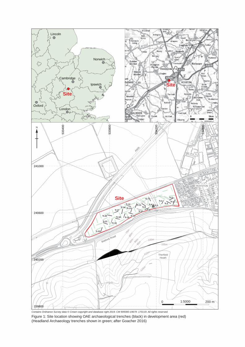
Fig.1 Site location showing OAE archaeological trenches (black), in development area (red), Headland Archaeology trenches shown in green; after Goacher 2016)
Fig. 2 Trench layout incorporating results of geophysical survey (Stratascan 2016) and previous trial trenching (Goacher 2016)
Fig. 3 Detail plan of Trenches 9, 12, 14 and 18 Fig. 4 Detail plan of Trenches 4, 5 and 6 Fig. 5 Detail plan of Trenches 5 and 6 with selected sections
List of Plates
Plate 1 Overview of western entrance of the enclosure in Trench 6, looking east. Plate 2 East facing section of enclosure ditch 8 in Trench 5 Plate 3 Pits 11 and 29 and feature 16 within Trench 5, looking south.
Land north of Baldock Road, Royston, Hertfordshire v.1
©Oxford Archaeology Ltd vii 19 February 2019
Summary
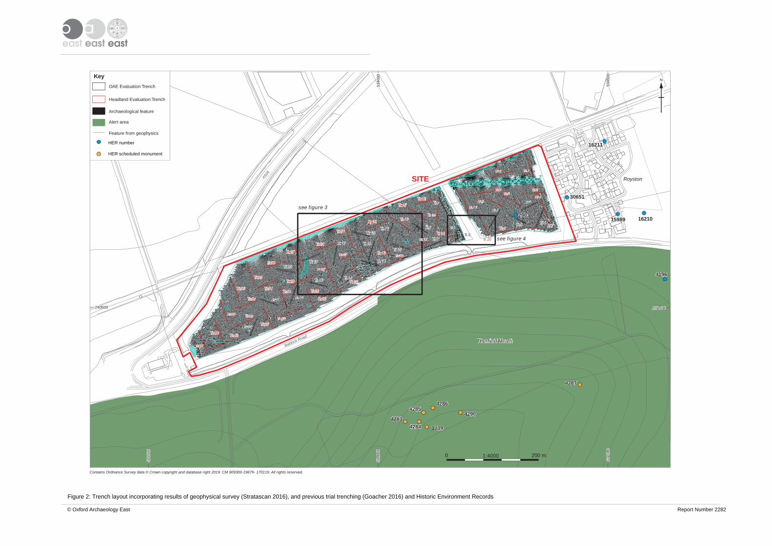
Between the 7th and 10th of January 2019 Oxford Archaeology carried out an archaeological evaluation on land north of Baldock Road, Royston (TL3414 4070). Twenty-two trenches were opened over an area of 15.4 ha, which had been subject to a previous phase of trial trenching by Headland Archaeology. This confirmed the presence of a rectangular ditched enclosure previously known from aerial photographs and geophysics. No dating evidence was recovered from this enclosure. Other trenches confirmed the presence of a post-medieval field system and the absence of any significant archaeological remains across the rest of the site.
Land north of Baldock Road, Royston, Hertfordshire v.draft
©Oxford Archaeology Ltd viii 19 February 2019
Acknowledgements
Oxford Archaeology would like to thank CgMs Heritage and Redrow Homes Ltd for commissioning this project. Thank you to Simon Wood who monitored the work on behalf of North Hertfordshire District Council.
The project was managed for Oxford Archaeology by Liz Muldowney. The fieldwork was directed by David Browne assisted by Jamie Hirst and Eben Cooper. Survey and digitizing was carried out by Sarita Louzolo, Gareth Rees, Emily Abrehart, Gillian Greer and Charlotte Walton. Thanks are also extended to the teams of OA staff that cleaned and packaged the finds under the management of Natasha Dodwell, processed the environmental remains under the management of Rachel Fosberry and prepared the archive under the supervision of Katherine Hamilton.
Land north of Baldock Road, Royston, Hertfordshire v.1
©Oxford Archaeology Ltd 1 19 February 2019
1 INTRODUCTION
1.1 Scope of work
1.1.1 Oxford Archaeology (OA) was commissioned by CgMs Heritage to undertake a trial trench evaluation at the site of a proposed residential development of approximately 300 houses on land west of Royston, North of Baldock Road.
1.1.2 The work was undertaken as a condition of Planning Permission (planning ref. 16/00387/1). Following initial scoping discussions with Hertfordshire Count Council, a written scheme of investigation was produced by CgMs Heritage detailing the approach and methods for the trial trenching programme (Flitcroft 2018).
1.2 Location, topography and geology
1.2.1 The site lies on the western side of Royston, to the north of Baldock Road and south of the Cambridge to Hitchin railway line. It is bound by the A505 to the east and to the west by recent residential development. The site gently slopes down from the south to the north running from 69.0m OD to the south to 60.0m OD in the north. It is at National Grid Reference (TL 3414 4070).
1.2.2 The area of proposed development consists of 15.4 hectares of agricultural land currently left as scrubland.
1.2.3 The geology of the area is mapped as Holywell Nodular Chalk Formation and consists of a thin sandy topsoil directly overlying chalk bedrock (http://mapapps.bgs.ac.uk/geologyofbritain/home.html, accessed 14/1/2019).
1.3 Archaeological and historical background
1.3.1 The full details of the archaeological background were discussed in a desk based assessment and the written scheme of investigation (Whiteley 2016, Flitcroft 2018), and is briefly summarised here.
1.3.2 The site lies directly south of Therfield Heath, where there is a nationally important group of prehistoric funerary monuments comprising a Late Neolithic Long Barrow (HER 40) and a Bronze Age round barrow cemetery (HER 6355). There are also a variety of other prehistoric monuments associated with this heath including a stockade enclosure (HER 4446) and a bank and ditch system known as “The Mile Ditches” which are found 400m to the south-west of the site (HER 2207) (Flitcroft 2018).
1.3.3 A rectangular enclosure, measuring approximately 25m across, was identified in aerial photographic imagery in 2007 on the southern edge of the site (Flitcroft 2018) and was targeted by Trenches 5 and 6 during the evaluation work described in this report.
1.3.4 An early 18th century account mentions a possible “Roman camp”, “a ¼ of a mile from Royston on the road to Baldock”. The location, interpretation and existence of this monument is uncertain. No obvious candidates are currently known (Flitcroft 2018).
1.3.5 The site was geophysically surveyed by Stratascan in 2015 and then evaluated by Headland Archaeology in November 2016, with the excavation of 42 trial trenches (Fig.
Land north of Baldock Road, Royston, Hertfordshire v.1
©Oxford Archaeology Ltd 2 19 February 2019
2). This produced evidence of a post-medieval field system (Flitcroft 2018. Stratascan 2016, Goacher 2016)

Land north of Baldock Road, Royston, Hertfordshire v.1
©Oxford Archaeology Ltd 3 19 February 2019
2 EVALUATION AIMS AND METHODOLOGY
2.1 Aims
2.1.1 The project aims and objectives were as follows:
• To confirm, as far as reasonably practicable, the location, extent, date, character, condition, significance and quality of any surviving archaeological remains.
• To assess the vulnerability/sensitivity of any exposed remains.
• To establish the ecofactual and environmental potential of archaeological deposits and features encountered.
• To establish the presence/absence, extent, date and character of any remains associated with the Prehistoric ritual landscape on Therfield Heath.
• To establish the potential for significant environmental deposits.
• To establish the potential for previously unsuspected archaeological evidence and to validate the results of the geophysical survey.
• To inform formulation of a strategy (if necessary) to avoid or mitigate impacts of the proposed development on surviving archaeological remains
• To produce a site archive for deposition with an appropriate Museum and to provide information for accessions to the Hertfordshire HER.
2.2 Methodology
2.2.1 Service plans were consulted before any work was undertaken and all trenches were scanned by a qualified operator using a CAT and Genny with a valid calibration certificate
2.2.2 Twenty-two trenches were opened up using a 20 tonne 360° type excavator using a 1.8m wide toothless ditching bucket. These trenches were planned to be 40m long by 1.8m wide, with one exception, Trench 6, which was to be 20m long and 4.5m wide. This was plan was changed during excavation as the enclosure ditch was only partly visible within Trench 6 and the width of the southern part of the trench was increased to 6.5m to fully expose a length of the enclosure ditch. The trenching provided an approximately 1% sample of the site which when combined with the Headland Evaluation provided a 3.5% sample of the site (Flitcroft 2018).
2.2.3 All machine excavation was supervised by a suitably qualified and experienced archaeologist.
2.2.4 Spoil was stored to the sides of the trenches with topsoil and subsoil stored separately to enable sequential backfilling post excavation.
2.2.5 Surveying was done using a survey-grade differential GPS (Leica GS08) fitted with “smartnet” technology with an accuracy of 5mm horizontal and 10mm vertical.
2.2.6 All archaeological features were hand-excavated.
2.2.7 All archaeological features and deposits as well as trenches were recorded using OA’s pro-forma sheets. Trench locations, plans and sections were recorded at appropriate scales and digital photographs were taken of all relevant features and deposits
Land north of Baldock Road, Royston, Hertfordshire v.1
©Oxford Archaeology Ltd 4 19 February 2019
2.2.8 All finds were retained for inspection.
2.2.9 A total of eight environmental samples were taken for processing at OA’s environmental facility at Bourn.
2.2.10 Site conditions were exceptional for the time of year, with dry weather and clear bright skies.

Land north of Baldock Road, Royston, Hertfordshire v.1
©Oxford Archaeology Ltd 5 19 February 2019
3 RESULTS
3.1 Introduction and presentation of results
3.1.1 Table 1, below, includes dimensions and orientation of all trenches regardless of presence or absence of archaeological features. Trenches with archaeological remains present are discussed in further detail below. Unusually, subsoil was only present in a few of the trenches and its presence is also recorded in the table below.
Trench Number
Approximate orientation
Length Width Average depth of Topsoil
Average depth of subsoil
Average total depth
1 NE-SW 40m 1.8m 0.25m 0.05m 0.30m
2 NE-SW 40m 1.8m 0.3m 0.2m 0.5m
3 NW-SE 40m 1.8m 0.25m 0.15m 0.4m
4 NE-SW 40m 1.8m 0.35m - 0.35m
5 N-S 35m 1.8m 0.35m - 0.35m
6 NNE-SSW 20m N half 4.5m, S half 6.7m
0.3m - 0.3m
7 N-S 40m 1.8m 0.35m - 0.35m
8 E-W 40m 1.8m 0.35m - 0.35m
9 NW-SE 40m 1.8m 0.25m 0.1m 0.35m
10 NW-SE 40m 1.8m 0.35m - 0.35m
11 NE-SW 40m 1.8m 0.35m - 0.35m
12 NW-SE 40m 1.8m 0.35m - 0.35m
13 NE-SW 40m 1.8m 0.35m - 0.35m
14 NW-SE 40m 1.8m 0.35m - 0.35m
15 NE-SW 40m 1.8m 0.35m - 0.35m
16 NE-SW 40m 1.8m 0.35m - 0.35m
17 E-W 40m 1.8m 0.35m - 0.35m
18 NW-SE 40m 1.8m 0.35m - 0.35m
19 NE-SW 40m 1.8m 0.3m - 0.35m
20 NW-SE 40m 1.8m 0.25m - 0.3m
21 NW-SE 40m 1.8m 0.3m - 0.35m
22 NE-SW 40m 1.8m 0.25m - 0.3m
Table 1 Trench dimensions and orientation
3.1.2 Context numbers were assigned in a continuous sequence from 1 upwards (contexts 1-39). They can be distinguished from numbers assigned during the Headland evaluation, where all contexts were allocated a four-digit number (prefixed by the trench number). A full inventory of all excavated contexts is appended to this report.
Land north of Baldock Road, Royston, Hertfordshire v.1
©Oxford Archaeology Ltd 6 19 February 2019
3.2 General soils and ground conditions
3.2.1 The deposit sequence for most of the trenches comprised a topsoil of grey-brown silty sand directly overlying natural chalk bedrock, although in Trenches 1, 2 and 3 a pale reddish-brown silty sand subsoil between the topsoil and the chalk bedrock.
3.2.2 Ground conditions throughout the evaluation were generally good, and the trenches remained dry throughout. Archaeological features, where present, were easy to identify against the underlying natural geology.
3.3 General distribution of archaeological deposits
3.3.1 The enclosure was located in Trenches 5 and 6 which had been targeted on it. There were also discrete features in both trenches.
3.3.2 Trench 4 contained a small post-medieval ditch.
3.3.3 Trench 9 contained two gullies/narrow ditches and similar features were also recorded in Trenches 12 and 14.
3.3.4 Trench 18 contained a substantial isolated post hole.
3.3.5 Trenches 1-3, 7-8, 10-11,13, 15-17 and 19-22 were all devoid of archaeological features.
3.4 Trench 4 (Fig. 4)
3.4.1 This trench contained a north to south aligned linear ditch (27) approximately 0.75m wide and 0.3m deep. It contained a light reddish brown silty fill (26) with similar characteristics to the subsoil present in trenches 1-3. It produced one sherd of roof tile and post-mediaeval pottery identified as honey glazed post-medieval redware dating between AD 1550-1800. This is similar to the ditches previously described by Headland Archaeology as belonging to their Phase 1 (0104, 0604, 0606, 1004, 1010, 1104, 3104 & 3204) (Goacher 2016)
3.5 Trench 5 & 6 (Figs 4 and 5)
3.5.1 These two trenches exposed ditches forming the north-western corner of a rectilinear enclosure previously identified by aerial photographs. The northern arm of this enclosure was formed by a substantial ditch (8) which was exposed in Trench 5, approximately 8m from the northern end of the trench (Fig. 5, Section 3, Plate 2). This east to west aligned ditch had a V-shaped profile and was approximately 1.4m wide and 0.8m deep. Its lower fill (9) was made up mostly of fragments of chalk, within a mid-greyish-brown silt matrix, and was 0.5m thick. This was sealed by an upper fill (10) which was less stony and was also a mid greyish-brown silt with frequent chalk fragments. This upper fill (10) produced several abraded long bone fragments belonging to a medium sized mammal and environmental sampling yielded only sparse charcoal.
3.5.2 Trench 6 exposed the western side of the enclosure. The north to south aligned continuation of ditch 8 was exposed running south for a length of 11.5m before terminating, leaving a 2m wide entrance beyond which the ditch continued and was exposed for a further 5m within the trench. The southern terminus (13) was excavated,

Land north of Baldock Road, Royston, Hertfordshire v.1
©Oxford Archaeology Ltd 7 19 February 2019
revealing a regular rounded terminus to a ditch of similar proportions and profile to ditch 8 (Fig. 5, Section 5). As with ditch 8, the enclosure ditch contained a simple fill sequence with a lower fill made up predominantly of chalk fragments (14), overlain by a mid greyish brown silt (15). No finds were recovered from the excavation of this part of the ditch.
3.5.3 Within the 2m wide entranceway on the western side of the enclosure was a substantial oval-shaped pit (18), aligned east-west and measuring 1.05m long, 0.88m wide and 0.68m deep with very steeply sloping sides and a flat base (Fig 5, Section 7, Plate 1). This had a lower fill of dark greyish brown stony silt (19) and an upper mid greyish brown silt (20). No finds were recovered from this feature and sampling recovered only small quantities of charcoal.
3.5.4 Approximately 1.5m west of the entrance was a cluster of three small pits or postholes (21,23 and 28). All were small and shallow, up to 0.75m in dimeter and 0.3m deep, and were filled by mid greyish brown silts; none produced finds.
3.5.5 In Trench 5, within the enclosure itself, were a group of three features, located approximately 7.5m from the southern end of the trench (11, 16 and 29; Plate 4). These comprised two sub-square post holes with vertical sides (11 and 29; 0.44m wide by 0.32m deep and 0.43m wide by 0.45m deep respectively) and a sub-circular feature (16) which was partially exposed on the eastern edge of the trench. This latter feature had a broad U-shaped profile and was 1.02m wide by 0.28m deep. All of these features were filled by a very dark grey brown silty sand with abundant charcoal. Small quantities of roof tile and slag were recovered from the fill of 29 (31), whilst environmental sampling of this fill and of the fill of pit 11 (12) produced hammer scale, implying light scale industrial activity associated with these features. It is unlikely they are contemporary with the enclosure. Pits 1006 and 1008, excavated by Headland in their Trench 10, were similar in shape but without the charcoal rich fill and were not located within the enclosure (Goacher 2016). Neither produced dating evidence.
3.6 Trench 9 (Fig. 3)
3.6.1 In Trench 9, two shallow gullies (31 and 33) were exposed. Both were shallow features with U-shaped profiles filled by mid brownish-grey silt. Gully 31 ran north-south, whilst 33 was aligned northeast to southwest; neither feature produced any finds.
3.7 Trench 12 & 14 (Fig. 3)
3.7.1 Trench 14 contained a possible gully terminus or pit (4). It was a broad shallow feature 1.05m long by 0.54m wide by 0.08m deep filled by a mid brownish-grey silt.
3.7.2 Trench 14 also contained a north-south oriented gully (6) which probably corresponds to a feature on the same alignment exposed in Trench 12 to the north (38). This feature was up to 0.44m wide and 0.09m deep and produced a single fragment of roof tile from its single mid brownish grey silt fill (7). These features seem to comprise elements of Headland Archaeology’s Phase 1 post-medieval strip field system (Goacher 2016).

Land north of Baldock Road, Royston, Hertfordshire v.1
©Oxford Archaeology Ltd 8 19 February 2019
3.8 Trench 18 (Fig. 3)
3.8.1 Trench 18 contained a substantial pit or post-hole (37), 0.7m in diameter and 0.6m deep. It was circular with near vertical sides and a rounded concave base. It was filled with two deposits (35 and 36), a lower dark brown silty sand and an upper light grey sandy silt.
3.9 Finds and environmental summary
3.9.1 The enclosure ditch itself produced only fragments of undiagnostic large mammal bone. Several other features produced post-medieval roof tile while one sherd of post-mediaeval redware was produced from a deposit (27) within ditch 28. Pit 30 (Trench 5) produced a small amount of slag (undiagnostic clinker).
3.9.2 Processing of eight environmental samples taken during the trenching showed that preservation of plant remains was generally very poor, with most samples, including those from the enclosure ditch, yielding only very small quantities of charcoal. The richest samples came from the fills of pits 11 and 29 (Trench 5), which contained large quantities of charcoal, occasional slag and hammerscale, indicative of metalworking activity.
Land north of Baldock Road, Royston, Hertfordshire v.1
©Oxford Archaeology Ltd 9 19 February 2019
4 DISCUSSION
4.1 Reliability of field investigation
4.1.1 The fact all features were cut in clear, chalk natural and that the evaluation fieldwork took place during bright sunny winter conditions made the archaeological features exceptionally clear. However, the lack of artefactual evidence makes dating problematic.
4.2 Evaluation objectives and results
4.2.1 The project aims and objectives were as follows:
• To confirm, as far as reasonably practicable, the location, extent, date, character, condition, significance and quality of any surviving archaeological remains.
It was confirmed that the key area of archaeological interest within the site area was the enclosure exposed in Trenches 5 and 6.
• To assess the vulnerability/sensitivity of any exposed remains
There are no especially vulnerable archaeological deposits which will require unusual methodology in later excavation. However, the shallow topsoil directly over the archaeological/geological horizon does mean that any further construction work or earth moving activity will damage archaeological remains.
• To establish the ecofactual and environmental potential of archaeological deposits and features encountered.
The chalk natural should produce good bone preservation, where it is present, however, very little has been recovered from any of the excavated features. There is little potential for the preservation of plant remains from this site.
• To establish the presence/absence, extent, date and character of any remains associated with the prehistoric ritual landscape on Therfield Heath.
The undated nature of the enclosure found in Trenches 5 and 6 mean it is possibly related to this landscape. However, this is not yet proven. All other features encountered can be assigned to the previously known post-medieval field system with reasonable certainty.
• To establish the potential for significant environmental deposits.
No obviously significant environmental deposits were encountered. The preservation of the plant remains was generally poor. The richest samples, containing charcoal, slag and hammerscale, came from the fills of two pits likely to be of post-medieval/modern date.

Land north of Baldock Road, Royston, Hertfordshire v.1
©Oxford Archaeology Ltd 10 19 February 2019
• To establish the potential for previously unsuspected archaeological evidence and to validate the results of the geophysical survey.
• The isolated pit/post hole in Trench 18 was the only unsuspected feature encountered, it is more likely to be post-medieval planting rather than a post hole. The evidence for metal working from several pits in Trench 5 (within the enclosure, but not thought to be related to it) was also unexpected.
• To inform formulation of a strategy (if necessary) to avoid or mitigate impacts of the proposed development on surviving archaeological remains
The evaluation has proven that the only area of significant archaeological remains is within the immediate environs of the enclosure and that the rest of the area is devoid of significant remains.
• To produce a site archive for deposition with an appropriate Museum and to provide information for accessions to the Hertfordshire HER.
The site archive has been prepared and is stored by Oxford Archaeology it will be deposited with the appropriate county store in due course
4.3 Interpretation
The Enclosure
4.3.1 Within the Trenches 5 and 6, the enclosure was defined by a substantial regular V-shape ditch approximately 1.4m wide and 0.8m deep. The presence of a western entrance with a large pit within the centre of it confirms the earlier aerial photographic interpretation (Flitcroft 2018). The presence of possible internal features is interesting but the similarity of pits 11 and 29 with Headlands pits 1006 and 1008 suggests these features are not restricted to the area within the enclosure and are very unlikely to be directly associated with it. The evidence for possible metal working confirmed by the presence of hammer scale in the samples cannot currently be associated with the enclosure. The lack of dating evidence is interesting as it implies an earlier date than would usually be associated with this form of enclosure (it would be expected that Roman, mediaeval or post-mediaeval features would contain finds when exposed on this scale). It is also rather isolated from other archaeological remains, being only associated with those on Therfield Heath and the wider post-medieval field system (Flitcroft 2018, Goacher 2016). Combined with the lack of finds this also suggests a lack of domestic activity within the enclosure.
The Field System
4.3.2 The presence of this field system was confirmed and there is no reason to contradict Headland’s interpretation of it as a series of small shallow post-medieval strip fields (Goacher 2016)
Land north of Baldock Road, Royston, Hertfordshire v.1
©Oxford Archaeology Ltd 11 19 February 2019
4.4 Significance
4.4.1 The post-medieval field system is of limited significance and could be expected in almost any field in the region. However, the enclosure is of unknown significance, as there is no dating evidence to categorise it. Its association with Therfield Heath and its possible prehistoric date does mean more work should be required and a later assessment of its significance made once it is dated. The possible evidence of metal working in the internal features is intriguing but is most likely due to intrusive post-medieval activity.
Land north of Baldock Road, Royston, Hertfordshire v.1
©Oxford Archaeology Ltd 12 19 February 2019
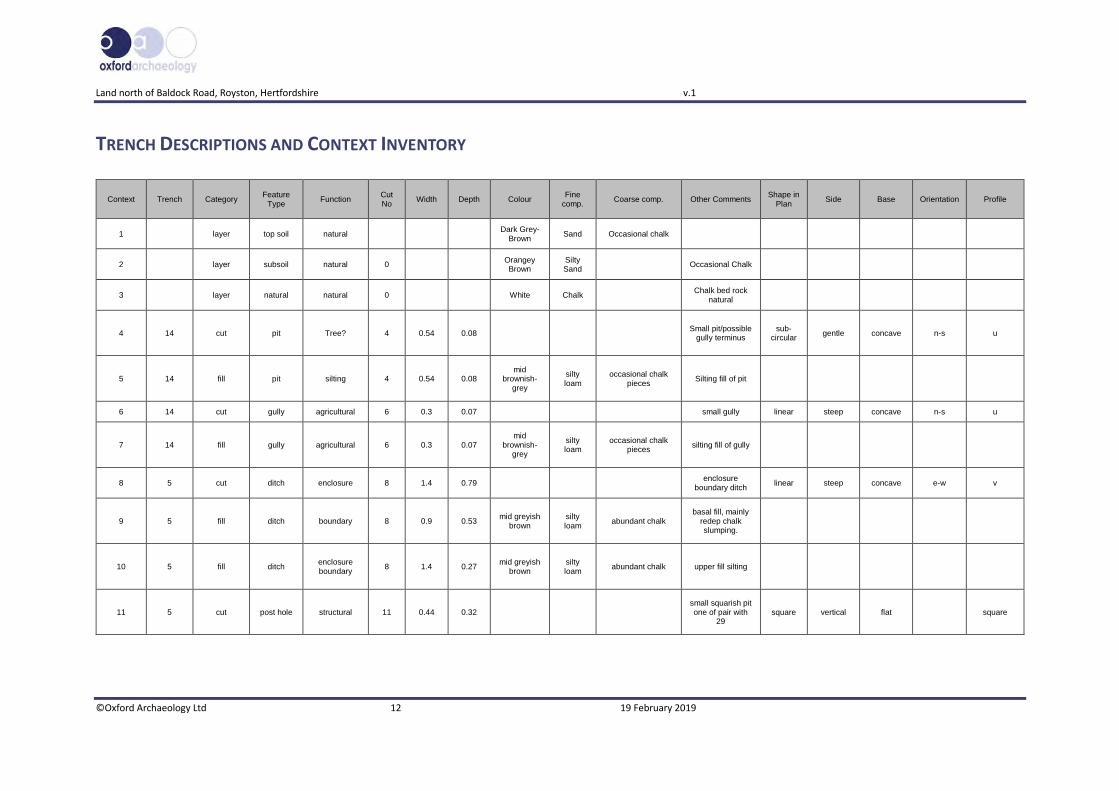
TRENCH DESCRIPTIONS AND CONTEXT INVENTORY
Context Trench Category Feature
Type Function
Cut No
Width Depth Colour Fine
comp. Coarse comp. Other Comments
Shape in Plan
Side Base Orientation Profile
1 layer top soil natural Dark Grey-
Brown Sand Occasional chalk
2 layer subsoil natural 0 Orangey Brown
Silty Sand
Occasional Chalk
3 layer natural natural 0 White Chalk Chalk bed rock
natural
4 14 cut pit Tree? 4 0.54 0.08 Small pit/possible
gully terminus sub-
circular gentle concave n-s u
5 14 fill pit silting 4 0.54 0.08 mid
brownish-grey
silty loam
occasional chalk pieces
Silting fill of pit
6 14 cut gully agricultural 6 0.3 0.07 small gully linear steep concave n-s u
7 14 fill gully agricultural 6 0.3 0.07 mid
brownish-grey
silty loam
occasional chalk pieces
silting fill of gully
8 5 cut ditch enclosure 8 1.4 0.79 enclosure
boundary ditch linear steep concave e-w v
9 5 fill ditch boundary 8 0.9 0.53 mid greyish
brown silty loam
abundant chalk basal fill, mainly
redep chalk slumping.
10 5 fill ditch enclosure boundary
8 1.4 0.27 mid greyish
brown silty loam
abundant chalk upper fill silting
11 5 cut post hole structural 11 0.44 0.32 small squarish pit one of pair with
29 square vertical flat square

Land north of Baldock Road, Royston, Hertfordshire v.1
©Oxford Archaeology Ltd 13 19 February 2019
12 5 fill post hole structural 11 0.44 0.32 dark
blackish brown
silty sand
frequent chalk abundant charcoal
possible refuse burnt material dump possibly
industrial
13 6 cut ditch enclosure entrance
13 1.4 0.68 ditch terminus no
finds rounded shape terminus
linear steep concave n-s v
14 6 fill ditch enclosure 13 1.2 0.4 dark
brownish grey
silty loam
very frequent chalk pieces
fill of enclosure entrance large
quantities of chalk backfill in this and
9 imply a chalk bank to the enclosure.
15 6 fill ditch enclosure 13 1.4 0.28 mid greyish
brown silty loam
moderate chalk pieces
silting fill of ditch terminus 13 not sampled due to
contamination by evaluation
16 5 cut ditch boundary 16 1.02 0.28
possible linear terminus may be pit not fully visible
in trench
circular steep concave e-w wide u
17 5 fill ditch boundary 16 1.02 0.28 dark
blackish brown
silty loam
frequent chalk abundant charcoal
very similar fill to 30 & 12 implies same time and
formation process
18 6 cut pit 18 0.88 0.68
steep deep pit right in the middle
of enclosure entrance
sub-circular
vertical flat e-w u shape
19 6 fill pit unknown 18 0.64 0.52 dark
brownish grey
silty loam
very frequent chalk lower fill of pit

Land north of Baldock Road, Royston, Hertfordshire v.1
©Oxford Archaeology Ltd 14 19 February 2019
20 6 fill pit unknown 18 0.88 0.24 mid greyish
brown silty loam
moderate chalk upper fill of pit in the middle of the
entrance
21 6 cut post hole structural 21 0.46 0.19
One of small cluster of post
holes to the east of the enclosure
entrance
circular vertical flat u shape
22 6 fill post hole structural 21 0.46 0.19 mid
brownish grey
silty loam
moderate chalk silting fill of post
hole
23 6 cut post hole structural 23 0.35 0.09
One of small cluster of post
holes to the east of the enclosure
entrance
circular steep flat u shape
24 6 fill post hole structural 23 0.35 0.09 mid
brownish grey
silty loam
moderate chalk silting fill of post
hole
25 6 cut post hole structural 25 0.36 0.05
One of small cluster of post
holes to the east of the enclosure
entrance
circular steep flat u shape
26 6 fill post hole structural 25 0.36 0.05 mid
brownish grey
silty loam
moderate chalk silting fill of post
hole
27 4 fill ditch boundary 28 0.75 0.3 light reddish
brown silty sand
moderate chalk silting fill
Land north of Baldock Road, Royston, Hertfordshire v.1
©Oxford Archaeology Ltd 15 19 February 2019
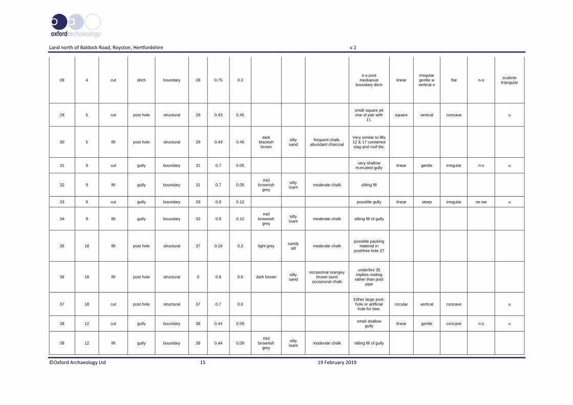
28 4 cut ditch boundary 28 0.75 0.3 n-s post
mediaeval boundary ditch
linear irregular gentle w vertical e
flat n-s scalene
triangular
29 5 cut post hole structural 29 0.43 0.45 small square pit one of pair with
11. square vertical concave u
30 5 fill post hole structural 29 0.43 0.45 dark
blackish brown
silty sand
frequent chalk, abundant charcoal
Very similar to fills 12 & 17 contained slag and roof tile.
31 9 cut gully boundary 31 0.7 0.05 very shallow
truncated gully linear gentle irregular n-s u
32 9 fill gully boundary 31 0.7 0.05 mid
brownish grey
silty loam
moderate chalk silting fill
33 9 cut gully boundary 33 0.9 0.12 possible gully linear steep irregular ne-sw u
34 9 fill gully boundary 33 0.9 0.12 mid
brownish grey
silty loam
moderate chalk silting fill of gully
35 18 fill post hole structural 37 0.16 0.3 light grey sandy
silt moderate chalk
possible packing material in
post/tree hole 37
36 18 fill post hole structural 0 0.8 0.6 dark brown silty sand
occasional orangey brown sand
occasional chalk
underlies 35 implies rooting
rather than post pipe
37 18 cut post hole structural 37 0.7 0.6 Either large post-hole or artificial
hole for tree. circular vertical concave u
38 12 cut gully boundary 38 0.44 0.09 small shallow
gully linear gentle concave n-s u
39 12 fill gully boundary 38 0.44 0.09 mid
brownish grey
silty loam
moderate chalk silting fill of gully

Land north of Baldock Road, Royston, Hertfordshire v.1
©Oxford Archaeology Ltd 16 19 February 2019

Land north of Baldock Road, Royston, Hertfordshire v.1
©Oxford Archaeology Ltd 17 19 February 2019
APPENDIX A FINDS REPORTS
A.1 Finds
By Carole Fletcher with animal bone identif ication by Hayley Foster
Introduction and Methodology
A.1.1 Archaeological works produced a small assemblage of finds recovered from features in Trenches 4, 5 and 14. The finds were weighed and rapidly recorded, with description and weight recorded in the table below. The assemblage and archive are curated by Oxford Archaeology East until formal deposition or dispersal.
Trench Context Cut Feature Material and description Count Weight (kg)
Date
4 27 28 Ditch Post-medieval Redware, moderately abraded jar body sherd, external and internal clear honey-coloured glaze with occasional iron mottles
1 0.007 1550-1800
Sub-rectangular fragment of flat tile (roof tile), part of edge survives. Dull red, quartz and grog-tempered with occasional calcareous inclusions. 13.5-14.5mm thick
1 0.023 Post-Medieval
5 10 8 Ditch Very abraded long bone fragments from a medium-size mammal
4 0.002 Not closely datable
30 29 Post hole Small sub-rounded fragment of ceramic building material in a dull red sandy fabric
1 0.002 Not closely datable
Formless fragments of vitrified coal ash (clinker)
2 0.005 Not closely datable
Sub-rectangular fragment of slag, probably hearth lining-type material. One surface is slightly glassy, the other rough and coated with vitrified clay. Most likely a fragment of vitrified fuel ash and clay
1 0.016 Not closely datable
14 7 6 Gully Irregular fragment of flat tile (roof tile), part of edge survives. Dull red, quartz and grog-tempered with occasional calcareous inclusion. 12.5-14mm thick
1 0.018 Post-Medieval
Table 2. Finds quantification
Retention, dispersal or display
A.1.2 The total assemblage is fragmentary, and no trench or feature appears to be worthy of further examination. Overall, the assemblage produced post-medieval roof tile and undiagnostic bone and slag-like material. This statement acts as a full record and the finds may be dispersed prior to archive deposition.
Land north of Baldock Road, Royston, Hertfordshire v.1
©Oxford Archaeology Ltd 18 19 February 2019
APPENDIX B ENVIRONMENTAL REPORTS
B.1 Environmental Remains
By Martha Craven
Introduction
B.1.1 Eight bulk samples were taken from features within the evaluated area at Baldock Road, Royston in order to assess the quality of preservation of plant remains and their potential to provide useful data as part of further archaeological investigations. Samples were taken from features encountered within trenches 5 and 6 from undated deposits.
Methodology
B.1.2 The total volume (up to 18L) of each of the samples was processed by tank flotation using modified Siraff-type equipment for the recovery of preserved plant remains, dating evidence and any other artefactual evidence that might be present. The floating component (flot) of the samples was collected in a 0.3mm nylon mesh and the residue was washed through 10mm, 5mm, 2mm and a 0.5mm sieve.
B.1.3 The dried flots were scanned using a binocular microscope at magnifications up to x 60 and an abbreviated list of the recorded remains are presented in Table 1. Identification of plant remains is with reference to the Digital Seed Atlas of the Netherlands (Cappers et al. 2006) and the authors' own reference collection. Nomenclature is according to Zohary and Hopf (2000) for cereals and Stace (1997) for other plants. Plant remains have been identified to species where possible. The identification of cereals has been based on the characteristic morphology of the grains and chaff as described by Jacomet (2006).
Quantification
B.1.4 For the purpose of this initial assessment, items such as seeds and cereal grains have been scanned and recorded qualitatively according to the following categories:
# = 1-5, ## = 6-25, ### = 26-100, #### = 100+ specimens
B.1.5 Items that cannot be easily quantified such as charcoal and molluscs have been scored for abundance
+ = occasional, ++ = moderate, +++ = frequent, ++++ = abundant
Key to tables:
f=fragmented

Land north of Baldock Road, Royston, Hertfordshire v.1
©Oxford Archaeology Ltd 19 19 February 2019
Results
B.1.6 Preservation of plant remains is by carbonisation and is very poor. All of the flots contain rootlets and molluscs which may have caused movement of material between contexts. The only preserved plant remain was a single charred cereal grain fragment from Sample 6, fill 22 of post-hole 21 (Trench 6).
B.1.7 Sample 2, fill 12 of pit 11 (Trench 5), and Sample 3, fill 30 of pit 29 (Trench 5), contained large quantities of charcoal, occasional slag and hammerscale. This is indicative of metalworking activity.
B.1.8 All of the samples contained relatively well preserved molluscs in moderate quantities.
Sam
ple
No
.
Co
nte
xt N
o.
Tren
ch /
area
no
.
Cu
t n
o.
Feat
ure
typ
e
Vo
lum
e p
roce
ssed
(L)
Flo
t V
olu
me
(ml)
Cer
eals
Snai
ls f
rom
flo
t
Ch
arco
al V
olu
me
(ml)
Po
tter
y
Met
al F
e
Slag
Ham
mer
scal
e
1 10 5 8 Ditch 17 40 0 +++ <1 0 0 0 0
2 12 5 11 Pit 16 80 0 +++ 70 0 0 # ++
3 30 5 29 Pit 19 400 0 ++ 300 0 0 # +
4 19 6 18 Pit 18 40 0 ++ 5 # 0 0 0
5 20 6 18 Pit 18 60 0 +++ 1 0 # 0 0
6 22 6 21 Post-hole 9 20 #f ++ <1 # 0 0 0
7 24 6 23 Post-hole 2 5 0 ++ <1 0 0 0 0
8 26 6 25 Post-hole 2 5 0 ++ <1 0 0 0 0
Table 3. Environmental samples from Baldock Road, Royston
Discussion
B.1.9 The recovery of sparse charred grain, chaff, weed seeds and charcoal indicates that there is little potential for the preservation of plant remains at this site. However, future excavation has the potential to recover larger, more meaningful assemblages that would contribute to the evidence of diet and economy at this site.
B.1.10 If further excavation is planned for this area, it is recommended that environmental sampling is carried out in accordance with Historic England guidelines (2011).
Land north of Baldock Road, Royston, Hertfordshire v.1
©Oxford Archaeology Ltd 20 19 February 2019
APPENDIX C BIBLIOGRAPHY
Cappers, R.T.J, Bekker R.M, and Jans, J.E.A. 2006 Digital Seed Atlas of the Netherlands Groningen Archaeological Studies 4, Barkhuis Publishing, Eelde, The Netherlands. www.seedatlas.nl Flitcroft, M. 2018 “A Written scheme of investigation for an archaeological programme of works. Land West of Royston and North of Baldock Road Royston.” CgMs Heritage. Goacher, H. 2016 “Land North of Baldock Road, West of Royston.Archaeological Evaluation”. Headland Arxchaeology.
Historic England 2011 Environmental Archaeology. A Guide to the Theory and Practice of Methods, from Sampling and Recovery to Post-excavation (2nd edition), Centre for Archaeology Guidelines
Jacomet, S. 2006 Identification of cereal remains from archaeological sites. (2nd edition, 2006) IPNA, Universität Basel / Published by the IPAS, Basel University.
Stace, C., 1997 New Flora of the British Isles. Second edition. Cambridge University Press Stratascan 2016, “Land West of Ivy House Farm, Royston, Hertfordshire – Geophysical Survey Report. Stratascan Ltd. Whiteley, S. 2016, “Heritage Statement for Land west of Royston and north of Baldock Road, Royston. CgMs Consulting.
Zohary, D., Hopf, M. 2000 Domestication of Plants in the Old World – The origin and spread of cultivated plants in West Asia, Europe, and the. Nile Valley. 3rd edition. Oxford University Press Electronic Sources
Geology of Britain Viewer British Geological Survey
http://mapapps.bgs.ac.uk/geologyofbritain/home.html, consulted 14/1/2019

Land north of Baldock Road, Royston, Hertfordshire v.1
©Oxford Archaeology Ltd 21 19 February 2019
APPENDIX D OASIS REPORT FORM
Project Details
OASIS Number oxfordar3-339255
Project Name Land north of Baldock Road, Royston, Hertfordshire Archaeological Evaluation Report
Start of Fieldwork 7/1/19 End of Fieldwork 10/1/19
Previous Work Yes Future Work Yes
Project Reference Codes
Site Code XHTBKR18 Planning App. No. 16/00387/1
HER Number EHT8620 Related Numbers
Prompt NPPF
Development Type Housing
Place in Planning Process After outline determination (eg. A a reserved matter)
Techniques used (tick all that apply)
☐ Aerial Photography – interpretation
☐ Grab-sampling ☐ Remote Operated Vehicle Survey
☐ Aerial Photography - new ☐ Gravity-core ☒ Sample Trenches
☐ Annotated Sketch ☐ Laser Scanning ☐ Survey/Recording of Fabric/Structure
☐ Augering ☐ Measured Survey ☒ Targeted Trenches
☐ Dendrochonological Survey ☐ Metal Detectors ☐ Test Pits
☐ Documentary Search ☐ Phosphate Survey ☐ Topographic Survey
☒ Environmental Sampling ☐ Photogrammetric Survey ☐ Vibro-core
☐ Fieldwalking ☐ Photographic Survey ☐ Visual Inspection (Initial Site Visit)
☐ Geophysical Survey ☐ Rectified Photography
Monument Period Object Period
Enclosure Uncertain Slag & Animal Bone Uncertain
Field System Post Medieval (1540 to 1901)
Pottery & CBM Post Medieval (1540 to 1901)
Choose an item. Choose an item.
Insert more lines as appropriate. Project Location
County Hertfordshire Address (including Postcode)
District North Hertfordshire Land North of Baldock Road Royston Hertfordshire SG8 9FL
Parish Royston
HER office Hertfordshire
Size of Study Area 15.4 ha
National Grid Ref TL3403 4063
Project Originators
Organisation Oxford Archaeology East
Project Brief Originator Simon Wood (North Hertfordshire District Council)
Project Design Originator Myk Flitcroft (CgMs Heritage)
Project Manager Liz Muldowney
Project Supervisor David Browne
Project Archives
Location ID
Physical Archive (Finds) NHDCMS XHTBKR18
Digital Archive OA East XHTBKR18
Paper Archive NHDCMS XHTBKR18
Physical Contents Present? Digital files associated with
Finds Paperwork associated with Finds
Animal Bones ☒ ☒ ☒ Ceramics ☒ ☒ ☒ Environmental ☒ ☒ ☒ Glass ☐ ☐ ☐

Land north of Baldock Road, Royston, Hertfordshire v.1
©Oxford Archaeology Ltd 22 19 February 2019
Human Remains ☐ ☐ ☐ Industrial ☒ ☒ ☒ Leather ☐ ☐ ☐ Metal ☐ ☐ ☐ Stratigraphic ☐ ☐ Survey ☐ ☐ Textiles ☐ ☐ ☐ Wood ☐ ☐ ☐ Worked Bone ☐ ☐ ☐ Worked Stone/Lithic ☐ ☐ ☐ None ☐ ☐ ☐ Other ☐ ☐ ☐
Digital Media Paper Media Database ☒ Aerial Photos ☐ GIS ☒ Context Sheets ☒ Geophysics ☐ Correspondence ☐ Images (Digital photos) ☒ Diary ☐ Illustrations (Figures/Plates) ☒ Drawing ☐ Moving Image ☐ Manuscript ☐ Spreadsheets ☐ Map ☐ Survey ☒ Matrices ☐ Text ☒ Microfiche ☐ Virtual Reality ☐ Miscellaneous ☒ Research/Notes ☐ Photos (negatives/prints/slides) ☐ Plans ☒ Report ☒ Sections ☒ Survey ☒
Further Comments
Site
Cambridge
Norwich
Ipswich
London
Lincoln
Oxford
Baldock Road
Baldock Road
SiteSite
Site
239800
240200
240600
241000
5334
00
5338
00
5342
00
5346
00N
115m
110m
105m
100m
95m90
m
85m
80m75
m
105m
100m
115m
75m
95m90
m
85m
80m75
m
110m
5km0
ROYSTON
A505
TherfieldHeath
1:50000 200 m
Tr.22
Tr.21Tr.19
Tr.18
Tr.16
Tr.12
Tr.13
Tr.14Tr.15
Tr.17
Tr.20
Tr.11
Tr.10
Tr.9Tr.8
Tr.7
Tr.6 Tr.5
Tr.4Tr.3
Tr.2
Tr.1
Tr.22
Tr.21Tr.19
Tr.18
Tr.16
Tr.12
Tr.13
Tr.14Tr.15
Tr.17
Tr.20
Tr.11
Tr.10
Tr.9Tr.8
Tr.7
Tr.6 Tr.5
Tr.4Tr.3
Tr.2
Tr.1
Contains Ordnance Survey data © Crown copyright and database right 2019. CM 909300-19679- 170119. All rights reserved.
Figure 1: Site location showing OAE archaeological trenches (black) in development area (red) (Headland Archaeology trenches shown in green; after Goacher 2016)
A505
Baldock Road
1
1
1
1
1
3
4
5
6
7
9
9
A
B
C
D
16211
30651
15989 16210
42834284
42854286
1739
4287
4290
4196
16211
30651
15989 16210
42834284
42854286
1739
4287
4290
4196
29032903
SITESITESITE
5335
00
5340
00
5345
00
5335
00
5340
00
5345
00
240500 240500240500 240500
5335
00
5345
00
5340
00
5335
00
5345
00
5340
00
Tr.22
Tr.21 Tr.19
Tr.18
Tr.16
Tr.12
Tr.13
Tr.14
Tr.15
Tr.17Tr.20
Tr.11
Tr.10
Tr.9
Tr.8
Tr.7
Tr.6
Tr.5
Tr.4
Tr.3
Tr.2
Tr.1
Therfield Heath
Royston
Tr.41
Tr.40Tr.42
Tr.38Tr.39
Tr.35Tr.32
Tr.37
Tr.36
Tr.33
Tr.34Tr.31
Tr.28
Tr.29
Tr.26
Tr.23
Tr.30
Tr.27Tr.20
Tr.19
Tr.17
Tr.18
Tr.24
Tr.25
Tr.22
Tr.21
Tr.16
Tr.15
Tr.12
Tr.13
Tr.14
Tr.11
Tr.10
Tr.6
Tr.8
Tr.9
Tr.5Tr.3
Tr.4
Tr.7
Tr.2 Tr.1
Tr.22
Tr.21 Tr.19
Tr.18
Tr.16
Tr.12
Tr.13
Tr.14
Tr.15
Tr.17Tr.20
Tr.11
Tr.10
Tr.9
Tr.8
Tr.7
Tr.6
Tr.5
Tr.4
Tr.3
Tr.2
Tr.1
Therfield Heath
Royston
Tr.41
Tr.40Tr.42
Tr.38Tr.39
Tr.35Tr.32
Tr.37
Tr.36
Tr.33
Tr.34Tr.31
Tr.28
Tr.29
Tr.26
Tr.23
Tr.30
Tr.27Tr.20
Tr.19
Tr.17
Tr.18
Tr.24
Tr.25
Tr.22
Tr.21
Tr.16
Tr.15
Tr.12
Tr.13
Tr.14
Tr.11
Tr.10
Tr.6
Tr.8
Tr.9
Tr.5Tr.3
Tr.4
Tr.7
Tr.2 Tr.1
see figure 4
see figure 3
HER number
HER scheduled monument
Archaeological feature
Alert area
Feature from geophysics
OAE Evaluation Trench
Headland Evaluation Trench
Key
Report Number 2282
easteasteast
© Oxford Archaeology East
Figure 2: Trench layout incorporating results of geophysical survey (Stratascan 2016), and previous trial trenching (Goacher 2016) and Historic Environment Records
N
1:40000 200 m
Contains Ordnance Survey data © Crown copyright and database right 2019. CM 909300-19679- 170119. All rights reserved.

1
3
4
5
B
Tr.19
Tr.18
Tr.16
Tr.12
Tr.13
Tr.14
Tr.15
Tr.17
Tr.11
Tr.10
Tr.9
Tr.8
Tr.7
Tr.29
Tr.26
Tr.23
Tr.20
Tr.19
Tr.17
Tr.18
Tr.24
Tr.25
Tr.22
Tr.21
Tr.16
Tr.15
Tr.13
Tr.19
Tr.18
Tr.16
Tr.12
Tr.13
Tr.14
Tr.15
Tr.17
Tr.11
Tr.10
Tr.9
Tr.8
Tr.7
Tr.26
Tr.23
Tr.20
Tr.19
Tr.17
Tr.18
Tr.24
Tr.25
Tr.22
Tr.21
Tr.16
Tr.15
Tr.13
31
33
38
37
4
6
240600 240600
240700 240700
5339
0053
3900
5340
0053
4000
5341
0053
4100
5341
00
141
OAE Trench
Headland Trench Cut number
Archaeological feature
Key
Results from geophysics
Projection of feature
SITESITE
SITE
1:10,0000 500 m
N
Report Number 2282© Oxford Archaeology East
Figure 3: Detail plan of trenches 9, 12, 14 and 18 incorporating results of geophysical survey (Stratascan 2016), and previous trial trenching (Goacher 2016)
N
1:7500 50 m
easteasteast

Tr.8
Tr.6
Tr.5
Tr.4
Tr.14
Tr.10
8
16
29
11
2828
SITESITESITE
1:10,0000 500 m
N
141OAE Trench
Headland Trench
Illustrated Section
Cut number
S.1
Archaeological feature
Key
Modern
1:5000 20 m
N
Results from geophysics
Figure 4: Plan of Enclosure within Trenches 5 & 6 with results of previous trenching (Goacher 2016) and geophysical survey.
© O
xford Archaeology E
astR
eport Num
ber 2282
ea
ste
ast
ea
st
1004
1006
1008
1010
1404
see insetsee figure 5
see figure 5

Enclosure
1404
Tr.6Tr.5
Tr.14
8
1621
29
25
S.5
23
11
S.3
13
S.7
18
N
9
10
8 Enclosure
10
Trench 5 - Section 3
NESW67.30m OD
13 Enclosure
14
15
WE
Trench 6 - Section 5
67.98m OD
Trench 6 - Section 7
18 Enclosure
19
20
NS67.93m OD
141
Illustrated Section
Break of slope
Cut number
S.1
Archaeological feature
OAE Evaluation Trench
Headland Evaluation Trench
Key
Modern
1:1000 5 m
0 1 m1:20
Report Number 2282© Oxford Archaeology East
Figure 5: Detail plan of trenches 5 and 6 with selected sections
easteasteast

Plate 2: East facing section of enclosure ditch 8 in Trench 5
Plate 1: Overview of western entrance of the enclosure in Trench 6, looking east
© Oxford Archaeology East Report Number 2282
easteasteast
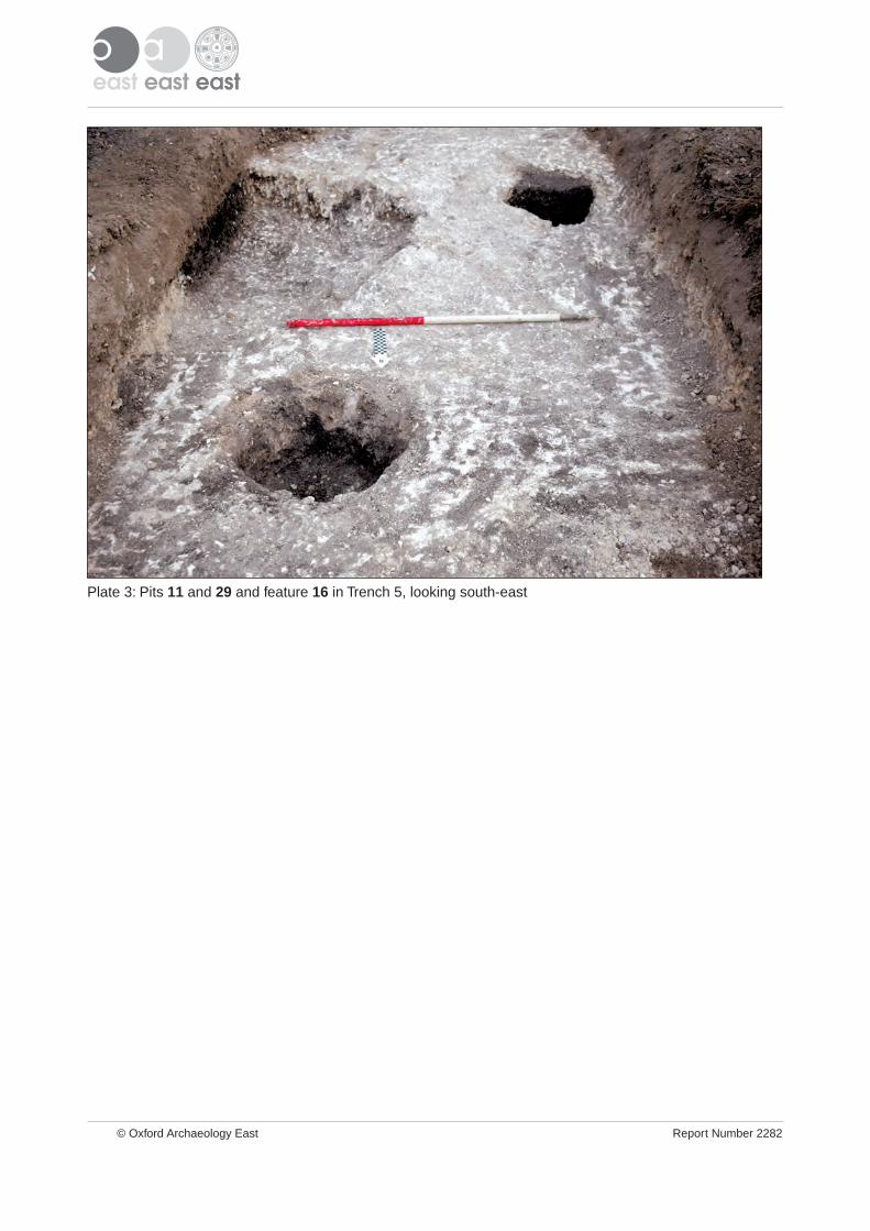
Plate 3: Pits 11 and 29 and feature 16 in Trench 5, looking south-east
© Oxford Archaeology East Report Number 2282
easteasteast