LAND AT WARTH MILL WATERFOOT GROUND … BL9 6BU Date: ... general guidance only. ... The nearest...
72
LAND AT WARTH MILL WATERFOOT GROUND INVESTIGATION AND RISK ASSESSMENT REPORT Prepared for: John Walsh Buckhurst Farm Walmersley Bury BL9 6SZ By: LK Consult Ltd Bury Business Centre Kay Street Bury Lancashire BL9 6BU Date: April 2010
Transcript of LAND AT WARTH MILL WATERFOOT GROUND … BL9 6BU Date: ... general guidance only. ... The nearest...

LAND AT
WARTH MILLWATERFOOT
GROUND INVESTIGATIONAND RISK ASSESSMENT
REPORT
Prepared for:
John Walsh
Buckhurst Farm
Walmersley
Bury
BL9 6SZ
By:
LK Consult Ltd
Bury Business Centre
Kay Street
Bury
Lancashire
BL9 6BU
Date: April 2010

John Walsh Land at Warth Mill, Waterfoot
LK Consult Ltd April 2010 Ref: CL-602-CL1474-02 [R1]
ii
LK Consult Ltd
Document Verification
Site Address
Land at Warth Mill, Waterfoot
Job Number
CL1436
Report Title
Ground Investigation and Risk Assessment Report
Date Issued
April 2010
Document Ref.
CL1474-02-R0
Prepared By
Michelle Fallone
Signature
Checked By
Dr Paul Quimby
Signature

John Walsh Land at Warth Mill, Waterfoot
LK Consult Ltd April 2010 Ref: CL-602-CL1474-02 [R1]
iii
EXECUTIVE SUMMARY Site Details This report was undertaken in support of a future planning application.
The site is located southeast of Warth Lane and west of Stansfield Road in the
area of Waterfoot, Rossendale at National Grid Reference 383000E 421740N.
The proposed development comprises residential end-use.
LKC note that the planning boundary has been altered since the undertaking of
the previous PRA, comprising a much smaller area of land and excluding the area
occupied by the existing good shed building.
Previous Work A preliminary risk assessment has previously been undertaken on the study site.
The conceptual model identified seven potential pollutant linkages associated with
contaminants present from the sites current and former uses.
Ground Investigation A ground investigation was designed based on the findings of the PRA and initially
involved the drilling of 12 window sample boreholes to depths of between 1.0mbgl
and 4.0mbgl. Many of the boreholes were located to target key contaminative
features.
Twelve representative soil samples were taken during the site investigation and
selected for chemical contamination analysis. In addition four of the soil samples
were also subjected to leachability analysis due to the absence of groundwater..
Ground Conditions The general ground conditions beneath the site comprised of made ground
followed by sandy clay, gravel and / or sand and gravel. This was underlain by
mudstone or sandstone bedrock.
Foundation Options Taking into account the ground conditions encountered and the SPT results, LKC
consider that the bedrock is the most suitable founding strata.
Soil Risk Assessment
& Recommendations
(Human Health)
Elevated levels of lead, B(a)P and D(a,h)A was encountered at the site,
associated with the made ground. A 600mm clean capping layer has been
recommended for the garden areas and a 300mm clean capping has been
recommended for soft landscaped areas.
It is recommended that United Utilities are contacted as there is a potential
requirement for protectaline water pipes and/or clean backfilled service trenches.
Gas Risk
Assessment &
Recommendations
Six gas monitoring visits have been undertaken at the site. The site falls within
Characteristic Situation 1 where no gas protection measures are required.
Controlled Waters
Risk Assessment
Elevated levels of PAHs were encountered in one leachate sample (WS101).
However LKC consider that the risk to controlled waters is low given that the
leaching test is particularly aggressive, not in equilibrium with the soil and
therefore the results may not be a true representation of dissolved concentration of
the contaminant. In addition, the absence of appreciable groundwater levels on
site will limit soil / water contact time.
Additional Risk
Assessment
Sulphate resistant concrete in line with DS-2 AC-2 will be required in the area
around WS109.
Elevated levels of phytotoxic copper and zinc were encountered across the site.
The measures required to mitigate the risk to human health, will also mitigate the
risk of phytotoxicity to any flora.
Additional Work It should be noted that this investigation is a scoping study and further site
investigation will be required following the clearance of the site. These works will
be required in order to confirm the findings of the scoping study and to fully
characterise the ground conditions and any contamination across the entire site.

John Walsh Land at Warth Mill, Waterfoot
LK Consult Ltd April 2010 Ref: CL-602-CL1474-02 [R1]
iv
CONTENTS
1 INTRODUCTION 5
2 PREVIOUS WORK 9
3 GROUND INVESTIGATION 14
4 GROUND CONDITIONS 18
5 GENERIC QUANTITATIVE RISK ASSESSMENT 21
6 CONCLUSIONS AND RECOMMENDATIONS 28
APPENDICES
Appendix A: Soil Profile Logs
Appendix B: Certificates of Analysis
Appendix C: Gas Monitoring
Appendix D: ATRISK Values

John Walsh Land at Warth Mill, Waterfoot
LK Consult Ltd April 2010 Ref: CL-602-CL1474-02 [R1]
5
1 INTRODUCTION
1.1 Background
LK Consult Ltd (LKC) has been commissioned by Mr Walsh to carry out a Geoenvironmental Investigation for land at Warth Mill, Waterfoot. This work is being undertaken to support the future redevelopment of the site for residential end use. Information is therefore required on the properties of any potential contaminants that may be present in, on or under the site. A Preliminary Risk Assessment (PRA) report has previously been undertaken by LKC (Ref:CL-602-CL1474-01, dated 12th June 2009) and should be read in conjunction with this report. Since the writing of the PRA report, it is understood that the planning boundary now relates only to the southern section of the site and as such this report reflects the new planning boundary.
1.2 Site Details
The site is located southeast of Warth Lane and west of Stansfield Road in the area of Waterfoot, Rossendale at National Grid Reference 383000E 421740N (Figure 1-1). The site is bounded by open land to the west, southwest, south and southeast, by Stansfield Road to the east and northeast, to the north by a former railway depot building and haulage company and to the northwest by Warth Lane. The site is currently occupied by an existing former mill building and has most recently been used as by a plant hire company for the storage and maintenance of plant machinery. The site is approximately 2.0ha in size (see Figure 1-2). There is currently no proposed layout plan available however LKA understands that the proposed development is to comprise residential dwellings.
1.3 Disclaimer
This report has been prepared by LKC who have exercised such professional skill, care and diligence as may reasonably be expected of a properly qualified and competent consultant experienced in preparing reports of a similar scope. However, to the extent that the report is based on or relies upon information contained in records, reports or other materials provided to LKC which have not been independently produced or verified, LKC gives no warranty, representation or assurance as to the accuracy or completeness of such information. This report is issued on the condition that LKC will not be held liable for any loss arising from ground conditions between sampling points (i.e. boreholes/trial pits/hand augers/surface samples) which have not been shown by the sampling points or related testing carried out during the investigation, nor for any loss arising from conditions below the maximum depth of the investigation. Opinions on such conditions, where given, are for general guidance only.

John Walsh Land at Warth Mill, Waterfoot
LK Consult Ltd April 2010 Ref: CL-602-CL1474-02 [R1]
6
This report is prepared solely for the benefit of Mr Walsh It may not be relied upon by, or submitted to a third party for their reliance for the purposes of valuation, mortgage, insurance and regulatory approval, until all invoices have been settled in full. Those using this information in subsequent assessments or evaluations do so at their own risk.

Figure 1-1: Location Plan, Land at, and to the rear of, Warth Mill, Waterfoot
Drawn: June 2009
S
Site
N
Crown Copyright [2009]. All rights reserved. Licence Number 100045070©

Figure 1-2: Location Plan, Land at Warth Mill, Waterfoot
Drawn: March 2010
S
Site Boundary
N
Crown Copyright [2009]. All rights reserved. Licence Number 100045070©

John Walsh Land at Warth Mill, Waterfoot
LK Consult Ltd April 2010 Ref: CL-602-CL1474-02 [R1]
9
2 PREVIOUS WORK
2.1 Summary of Existing Information
A Phase I Desk Study and Preliminary Risk Assessment report has previously been undertaken by LKC (ref. CL-602-CL1474-01, dated 12th June2009). The previous report was based upon the previous planning proposed planning boundary, which was a much larger area of land (2.96ha area). The planning boundary has subsequently been altered to comprise a smaller area (as per Figure 1-2). The report comprised a review of factual information sources such as site history via historical mapping, geology, hydrogeology and a landfill and Coal Authority search. A conceptual model was also provided. A summary of the available information is provided below along with an adaptation of the preliminary conceptual model.
2.2 Site History
The primary historical onsite features that may be of concern were the railway sidings from mapping dating from 1893 to 1981, Vale Mills and associated chimneys (1893 to 1981 mapping) and Warth Mill from 1893 until 1991, when it was in use as a garage. A refuse heap and a number of embankments were also noted on site. The refuse heap is no longer present on site, however the embankments were observed to comprise fill material such as brick, concrete, ash and tarmac. Key historical features for the site are presented in Figure 2-1. The study site is currently occupied by plant hire company for the storage, fuelling and maintenance of plant and haulage vehicles. Two above ground fuel tanks were identified on site.
The immediate surrounding areas have been mainly developed for residential and some commercial usage. Several potentially contaminative land-uses have been identified within 250m of the study site including mills, works, allotment gardens, depots, a smithy, several chimneys and a garage.
2.3 Site Geology, Hydrogeology and Hydrology
BGS Sheet 76 (Rochdale 1:50,000) indicates that the drift geology beneath the northern part of the site comprises Alluvium. No drift geology is indicated beneath the remainder of the study site. BGS Sheet 76 (Rochdale 1:63.360) indicates that the solid geology beneath the site is indicated as the Millstone Grit Series. Bands of Holcombe Grit are also indicated in the eastern and southern parts of the site. Two geological faults are indicated to run through the centre of the site in a northwest to southeasterly direction with down throws to the northeast. Strata in the immediate surrounding areas are indicated to be horizontal.

John Walsh Land at Warth Mill, Waterfoot
LK Consult Ltd April 2010 Ref: CL-602-CL1474-02 [R1]
10
The Millstone Grit Series are classified as a Minor Aquifer. The nearest surface watercourse is the River Irwell, which is located in the western part of study site. The Envirocheck Report has identified one groundwater abstraction licence within 250m of the site. This is located 205m northeast of the site for manufacturing. This license has been revoked. The Envirocheck Report has identified four surface water abstractions licences within 250m of the site. The nearest abstraction license is held 50m south of the study site for boiler feed and drinking, cooking, sanitary and washing for industrial premises. This license has been revoked.
The Environment Agency website indicates the western part of the site is at risk from flooding from the River Irwell. The western part of the study site is indicated to be an area likely to be affected by a major flood, with a 0.1% (1 in 1000) or greater chance of occurring each year.
2.4 Landfill Sites
Envirocheck records show there are no known/registered /historic landfill sites within 250m of the site boundary. A review of historical Ordnance Survey mapping by LKC has identified an additional one site where landfill may be present. This is a former reservoir located 140m northwest of the study site. The reservoir was present between the 1893 and 1911 mapping editions.
2.5 Coal Authority Search
A Coal Authority Ground Stability Report has been undertaken on the site. A summary of the results of the search show the following: The property is not within the likely zone of influence of any past underground coal
workings. The property is not within the likely zone of influence of any present underground
coal workings. The property is not in an area where the Coal Authority believes there is coal at or
close to the surface which may have been worked at sometime in the past. There are is not known coal mine entries within, or within 20m of the boundary of
the property. The property is not situated within the Cheshire Brine Subsidence Compensation
District.
2.6 Site Reconnaissance
A reconnaissance of the site was carried out at on the 10th June2009. Key observations from the current planning boundary during the walkover included: The study site was accessed off Warth Lane, to the south of Bacup Road. The ground level in the southern part of the study site was noted to vary significantly,
with the southern extents of the site consisting of steep slopes, extending approximately 25-30m above the central part of the site.
The eastern part of the site was also noted to be located at a slightly higher elevation (3.0m) than the central part of the site.
The study site was occupied by Buckhurst Plant Hire for the hire, storage and maintenance of plant machinery.
The ground cover across the majority of the southern part of the study site comprised a mixture of concrete or coarse gravel.

John Walsh Land at Warth Mill, Waterfoot
LK Consult Ltd April 2010 Ref: CL-602-CL1474-02 [R1]
11
Several areas of hydrocarbon staining were noted on the ground surface, particularly in the areas occupied by plant.
The central part of the site was occupied by a large building. The western part of this building was in use as offices and was constructed mainly from brick, with the remainder of the building being used for the maintenance of machinery and storage of spare parts and was mainly constructed from timber.
An above ground diesel fuel tank and machine washing area was observed adjacent to the northwestern corner of the existing building. Hydrocarbon staining was noted on the surface around the tank.
A chemical store was also noted in the northwestern part of the building. The southern extent of the site was occupied by a large, steep, vegetated slope. A drainage ditch filled with water was noted at the base of the slope. Arisings from the
excavation of the drainage ditch comprised coarse gravel including ash and tarmac. A large embankment, comprising coarse sand and gravel material, including brick,
concrete, ash and tarmac, was observed in the southwestern extent of the site. The River Irwell was observed to encroach into the western part of the site.
2.7 Potential Contaminants
The preliminary contamination conceptual model adapted from the conceptual model in the previous LKC report to reflect the new site boundary and is summarised in Table 2-1 below. Potential contaminants that may be present on the site could be associated with any level raising or sub base material for existing buildings on site, particularly ash and clinker waste from hearths and boilers. Contaminants may include heavy metals (such as arsenic and lead), Asbestos Containing Materials (ACMs) and Polycyclic Aromatic Hydrocarbons (PAHs, such as benzo(a)pyrene (B(a)P)) 1. Atmospheric fallout from chimneys both on site and nearby may also contribute to heavy metal and PAH contamination on site. ACMS may also be present within the existing buildings on site given their age. Additionally, localised spillages of hydrocarbons associated with the current use of the site for the storage, fuelling and maintenance of plant machinery could also contribute to hydrocarbon contamination. A chemical store was also noted on site, however the type of chemicals stored is unknown and could comprise Volatile and Semi Volatile Organic Compounds (VOCs and SVOCs). The pathways by which the receptors could be exposed to the potential hazards present are through dermal contact, inhalation, uptake or ingestion of contaminated soils or dust, migration along service runs, permeation through and attack of building materials and consumption of potentially tainted water supplies and uptake of contaminants. Potential receptors with respect to human health and hazards present on the site include residents of the proposed development, future site construction workers and landscaped areas. Depending on the nature and concentration of the potential contaminants and the underlying Minor Aquifer and River Irwell may also be considered as potential receptors along with building materials and services.
1 Defra (2002). “Potential Contaminants for the Assessment of Land.” R&D Publication CLR 8

John Walsh Land at Warth Mill, Waterfoot
LK Consult Ltd April 2010 Ref: CL-602-CL1474-02 [R1]
12
Table 2-1 Contamination conceptual model for the Land at Warth Mill, Waterfoot.
(Key: ? – pollutant linkage possible; x – pollutant linkage unlikely)
The conceptual model for the Warth Mill site identified seven potential pollutant linkages and all are considered possible at this stage. It was considered that detailed intrusive investigations were required to further assess these linkages. These investigations are outlined in Section 3.
Contaminant
Gases Contaminants
Pollutant
Linkage
No.
ACM
Hazardous Ground Organic Inorganic
Pathway Receptor
1 ? x x ? ?
-Dermal Contact. -Ingestion of soils and vegetables. -Inhalation of contaminated soil, fibres and dust.
-Future site residents inc. veg uptake. -Future site workers. -Nearby residential and commercial buildings (windblown dust).
2 x x x ? x
-Inhalation of vapours. -Vapour migration through alluvium and Millstone Grit deposits. -Vapour migration through non-cohesive made ground.
-Future site residents. -Future site workers. -Nearby residential and commercial buildings.
3 x ? x x x
-Inhalation of hazardous gas. -Migration through Alluvium and Millstone Grit. -Migration through underlying faults.
-Future site residents. -Future site workers. -Nearby residential and commercial buildings.
4 x x x ? ?
-Groundwater migration through underlying Alluvium and Millstone Grit. -Perched waters migration on site.
-Minor Aquifer. -The River Irwell
5 x ? x x ? -Contact with potential hazards -Site Buildings
6 ? x x ? ?
-Ingestion of tainted water supply. -Direct contact and inhalation of dust and vapours.
-Future site residents. -Future pipe installers. -Maintenance workers.
7 x x x x ? -Root uptake of phytotoxic contaminants
-Flora in future landscaping.

4
1
23
511
6
12
7
8 9
10
Figure 2-1: Historic Features Plan, Warth Mill, Waterfoot
Drawn: June 2009 Current Site Boundary
N
Crown Copyright [1993]. All rights reserved. Licence Number 100045070©
Buildings - still present
1 = Former Goods Shed & Current Depot Building3 = Current Unreferenced Building built circa 19915 = Former Warth Mill & currently annotated as a Garage
2 = Former Railway SidingsPresent between 1893 and 1981
Embankments - still present
4 - Associated with former Railway Sidings6 = Adjacent to Pond / Reservoir8 = Adjacent to site boundary and former Vale Mill
Water Features-still present
7 = Pond / Reservoir10 = River Irwell
9 = Former Vale Works (1893-1961)
11 = Former Refuse Heap (1961-1991)
12 = Former Timber Yard (1930 -1961)

John Walsh Land at Warth Mill, Waterfoot
LK Consult Ltd April 2010 Ref: CL-602-CL1474-02 [R1]
14
3 GROUND INVESTIGATION
3.1 Site Investigation Design and Methodology
In order to investigate the potential pollutant linkages identified in the preliminary contamination conceptual model, an intrusive investigation was undertaken between the 6th and the 20th January 2010. It should be noted that the site investigation was limited to main areas of the site only. The embankments and steep slopes in the far southern extent of the site could not be accessed safely. In addition, the site is active and the presence of moving plant machinery was a health and safety consideration for both the undertaking of the investigation works and for subsequent monitoring visits. Furthermore the presence of static machinery, skips, containers and spare parts also restricted access into some areas of the site. Access inside the building was unavailable given that the site was still in use. Given the above restrictions, this site investigation is considered to be a scoping study in order to support the planning application for the site.
The site investigation involved the drilling of twelve window sample boreholes referenced WS101 to WS110 between 1.0m below ground level (mbgl) to 4.0mbgl. The number of boreholes is considered appropriate for a scoping study. Some of the borehole locations were positioned, were possible, to target potentially contaminative features on site. Table 3-1 below indicates what, if any, features were targeted by each sampling location.
Borehole ID
Targeted Feature
WS101 Storage Area for Machinery WS102 Former Vale Works WS103 Former Vale Works WS104 Close to Former Vale Works and Site
Coverage WS105 Close to Existing Embankment and
Storage of Machinery WS106 Former Timber Yard WS107 Above Ground Fuel Tank WS108 Storage of Machinery and Parts
WS108A Storage of Machinery and Parts WS109 Close to Warth Mill Building and
Storage of Machinery and Parts WS110 Former Refuse Heap
WS110A Former Refuse Heap Table 3-1: Targeting of Contaminative Features

John Walsh Land at Warth Mill, Waterfoot
LK Consult Ltd April 2010 Ref: CL-602-CL1474-02 [R1]
15
All sample locations are shown in Figure 3-1. All the window sample descriptions were carried out in accordance with BS59302 by suitably qualified and experienced members of staff. Soil profile logs for the site are presented in Appendix A.
3.2 Sample Collection
Standard sampling protocol and preservation of samples was undertaken as described in the EA guidance on site investigation3,4. Soil samples of approximately 500kg were recovered in plastic tubs and amber jars and vials. All the samples were labelled and stored in cool boxes prior to being collected by courier for delivery to Chemtest Laboratories in Newmarket. If samples could not be delivered the same day then samples were stored in the LKC sample fridge at approximately 4˚C. Samples were tracked using appropriate Chain of Custody forms provided by Chemtest. Twelve representative soil samples taken during the site investigation were selected for chemical contamination analysis. All soil samples were subjected to the following:
Arsenic, cadmium, total chromium, hexavalent chromium, copper, lead, mercury, nickel, selenium, zinc, boron, cyanide, water soluble sulphate, pH, speciated banded TPH (TPH CWG), BTEX, MTBE, USEPA speciated polyaromatic hydrocarbons (PAHs), asbestos screen and organic matter.
In addition, three samples (WS102, WS106 and WS107) were subjected to analysis for VOCs and SVOCs. It should be noted that hexavalent chromium soil analysis is analysed using USEPA recommended method of Alkaline leach. This method limits chromium (VI) reduction to chromium (III)5. Furthermore, in the absence of sufficient volumes of groundwater on site, four soil samples (WS101, WS105, WS107 and WS110) were subjected to leachate analysis. It should be noted that the leaching test is aggressive (de-ionised water) and is not in aqueous equilibrium (steady state) with the solid sample. This may cause rapid dissolution and overestimation of the aqueous phase concentrations compared to groundwater in contact with contaminated soils.
The samples were subjected to analysis for a similar suite of contaminants to those listed above.
The majority of the tests are UKAS or MCERTS accredited and further details are given in the certificate of analyses presented in Appendix B. A summary of the analytical results is given in Section 5.
2 British Standard (BS5930:1999). “Code of Practice for Site Investigations.” 3 EA (2000). “Technical Aspects Of Site Investigation. Volume 1 (Of 2) Text Supplements Research and Development Technical Report.” P5-065/Tr. 4 EA (2000). “Technical Aspects Of Site Investigation. Volume 2 (Of 2) Text Supplements Research and Development Technical Report.” P5-065/Tr. 5 Palmer, CD and Roberts, WP (1994). “Natural Attenuation of Hexavalent Chromium in Groundwater and Soils.” EPA Issue EPA/540/5-94/505.

John Walsh Land at Warth Mill, Waterfoot
LK Consult Ltd April 2010 Ref: CL-602-CL1474-02 [R1]
16
3.3 Geotechnical Testing
In-situ geotechnical tests were also performed in the boreholes to further characterise the natural sub-soil conditions. In total, 14 standard penetration tests (SPTs) were undertaken and are illustrated on the borehole logs in Appendix A.
A summary of the in-situ testing is given in Section 4.4.
3.4 Gas Monitoring
Four of the boreholes (WS102, WS106, WS107 and WS110A) were converted to gas and groundwater monitoring standpipes. Installation details for this site are typical for gas monitoring wells as described in CIRIA C6656 comprising 1.0m of plain pipe and a length of slotted pipework surrounding by pea gravel and sealed at the tops with bentonite. The response zones for the all boreholes were installed along the entire length of the borehole as specific response zones could not be isolated due to the relatively shallow depth of each borehole. Monitoring was undertaken using a Geotechnical Instruments GA2000 plus in accordance with the monitoring protocol outlined in CIRIA C665 (flow rate measured first). Monitoring visits also included periods of falling barometric pressure and heavy rainfall to demonstrate worst atmospheric conditions.
The wells have been monitored on sox occasions between 2nd February 2010 and 29th April 2010. The gas monitoring results to date are reproduced in full in Appendix C and are summarised in Section 5.4.
6 CIRIA (2007). “Assessing Risks Posed by Hazardous Ground Gases to Buildings.” CIRIA C665.

WS109
WS110WS110A
WS107
WS108
WS108A
WS105
WS106WS103
WS104WS102
WS101
Figure 3-1: Sampling Location Plan, Warth Mill, Waterfoot
Drawn: January 2010
Southern Site Boundary
N
Crown Copyright [1993]. All rights reserved. Licence Number 100049644©
Window Sample Borehole

John Walsh Land at Warth Mill, Waterfoot
LK Consult Ltd April 2010 Ref: CL-602-CL1474-02 [R1]
18
4 GROUND CONDITIONS
4.1 Summary
The general ground conditions beneath the Warth Mill, Waterfoot site comprised of made ground underlain by sandy / gravelly clay, sand, gravel, mudstone and / or sandstone. Typical soil profiles are summarised below in Table 4-1 and include all sampling locations encountered both within and outside of the current planning boundary.
Description of
Stratum
Depth of
Stratum (mbgl)
Thickness of
Stratum (m)
Typical Description
Made Ground 0.0 - 2.8 0.5 -2.8 Reworked clay / sand /
gravel with ash,
sandstone fragments,
brick, wood, occasional
shale and shredded
rubber.
Clay 0.75 – 2.8 0.25 – 1.5 Sandy or gravelly CLAY
with fine to coarse gravel
(WS103, WS104, WS105,
WS107 and WS110A
only).
Sand / Gravel 0.8 > 4.0 0.45 >4.0 Sandstone GRAVEL or
SAND and GRAVEL,
(WS106, WS107,
WS108A and WS110A
only)
Bed Rock 0.5 - >3.3 0.1 > 2.2 SANDSTONE (WS101,
WS102, WS103, WS104
and WS105) /
MUDSTONE (WS106 and
WS109)
Table 4-1: Summary of Soil Profile encountered across Warth Mill, Waterfoot
4.2 Made Ground
Made ground was encountered in all of the sampling locations to depths between 0.5mbgl and 2.8mbgl and comprised reworked clay, sand and / or gravel mixed with ash, sandstone fragments, shale, brick and occasional wood. Shredded rubber was encountered in the eastern part of the site in the area of the former refuse heap. No visual or olfactory evidence of hydrocarbon contamination was encountered in any of the boreholes
4.3 Drift Geology
Superficial natural ground was encountered in seven of the sampling locations (WS103, WS104, WS105, WS106, WS107, WS108A and WS110A) and generally comprised a sandy / gravelly clay, sandstone gravel of sand and gravel.

John Walsh Land at Warth Mill, Waterfoot
LK Consult Ltd April 2010 Ref: CL-602-CL1474-02 [R1]
19
No visual or olfactory evidence of hydrocarbon contamination was encountered in the superficial natural ground in any of the sampling locations.
4.4 Solid Geology
Bedrock was confirmed in all of the sampling locations with the exception of WS107, WS108, WS108A, WS110 and WS110A. WS107, WS108A and WS110A were all terminated due to refusals in natural sand and gravel deposits and WS108 and WS110 were terminated due to refusals in the made ground. Sandstone was encountered at depths between 0.5mbgl (WS102) and 2.8mbgl (WS101). The sandstone was recorded as weathered in WS102 and WS103. Mudstone bedrock was encountered in WS106 at 2.8mbgl and in WS109 at 1.6mbgl.
No visual or olfactory evidence of hydrocarbon contamination was encountered in the bedrock in any of the sampling locations.
4.5 Groundwater Monitoring
Groundwater monitoring has been undertaken on the boreholes converted to wells on three occasions to date. Results are summarised in Table 4-2.
BH
Ref
Water
Strike
Depths
(mbgl)
Depth to top of groundwater
(mbgl)
No.
Visits
Groundwater
Sampled
Y or N?
Free
Product
Detected
(using
interface
probe)
Hydrocarbon
Odours in
Groundwater
(No. Visits)
Max Min Base* Response
Zone
WS102 N/A Dry 1.9 1.9 1.0-2.0m 6 N No 0
WS106 2.45 2.0 1.85 2.1 1.0-3.0m 6 N No 0
WS107 2.00 1.7 1.6 1.8 1.0-2.0m 6 N No 0
WS110A N/A 2.98 2.85 3.3 1.0-4.0m 6 N No 0
Table 4-2: Summary of water strike depths within boreholes at the study site.
* refers to shallowest depth of base recorded
Both the groundwater strikes recorded during the site investigation were observed between 2.0-2.4mbgl within the gravel / sand and gravel strata.
4.6 Geotechnical Testing
In-situ geotechnical tests were performed in the boreholes to further characterise the sub-soil conditions. In total, twelve standard penetration tests (SPTs) were undertaken. The results of these tests are summarised within Table 4-4 below and provided within the profile logs in Appendix A.

John Walsh Land at Warth Mill, Waterfoot
LK Consult Ltd April 2010 Ref: CL-602-CL1474-02 [R1]
20
Depth (m)
WS101 WS102 WS103 WS104 WS105
1.0 8 (MG) - - - 15 (MG)
2.0 6 (MG) 87 (SS) REF (SS) - REF (SS)
2.7 - - - REF (SS) -
3.0 REF (SS) - - - -
Depth (m)
WS106 WS107 WS108A WS109 WS110A
1.0 47 (MG) 32 (G) REF (S&G) - -
1.6 - - - REF(MS) -
2.0 18 (G) REF (S&G) - - -
3.0 REF (MS) - - - 20 (S&G)
Table 4-3. Summary of SPT (N) values recorded from the window sample boreholes at the Warth Mill site. MG = Made Ground, S&G = Sand and Gravel, G = Gravel, SS = Sandstone, MS = Mudstone and REF = Refusal Of the SPTs undertaken, four were undertaken within the made ground strata, returning ‘N’ values between 6 and 47. Two of these were undertaken in granular made ground and returned ‘N’ values of 15 and 47, characterising these deposits as medium dense to dense. The remaining two SPTs were undertaken in cohesive made ground, returning ‘N’ values of 6 and 8, characterising these deposits as firm. One SPT was undertaken in the natural gravel deposits, returning an ‘N’ value of 32, characterising the gravel as dense. Three SPTs were undertaken in the natural sand and gravel deposits, returning ‘N’ values of 20 and >50 (refusal), characterising the sand and gravel as medium dense to very dense. Five of the SPTs were undertaken within the sandstone strata, returning ‘N’ values between 87 and >50 (refusal), characterising the sandstone as hard. The remaining two SPTs were undertaken within the mudstone strata, returning ‘N’ values of >50 (refusal), characterising the mudstone as hard.
4.6.1 Foundation Solution Options
At this stage the proposed building loadings and proposed levels and have yet to be fully established. Taking into account the ground conditions encountered and the SPT results, LKC consider that the sandstone / mudstone bedrock would be the most suitable founding strata for the site.

John Walsh Land at Warth Mill, Waterfoot
LK Consult Ltd April 2010 Ref: CL-602-CL1474-02 [R1]
21
5 GENERIC QUANTITATIVE RISK ASSESSMENT
5.1 Introduction
Current good practice requires that the findings from a site investigation be evaluated on a site specific basis, using a risk based approach. Risk assessment involves identification and evaluation of the hazards presented by the concentrations of contaminants measured, followed by an evaluation of the risks, which are associated with these hazards (CLR117). Information gathered from the risk assessment has been collated in the revised contamination conceptual model in Section 5.5. Following the undertaking of the previous PRA report, the planning boundary has been altered to comprise a smaller area of land. Therefore, for the purpose of this report, the site investigation and risk assessment has been undertaken on the current planning boundary.
5.2 Soil Risk Assessment
The results of the soil samples were compared to the new Soil Guideline Values (SGVs). Unfortunately, there are only a select number of new SGVs currently available and therefore, where there are no SGVs ATRISK Site Specific Values (SSVs) have been used as screening values. These have been generated using the CLEA V1.04 model8 based on 6% SOM and although no justification for their derivation has been detailed for chemical parameters is still considered scientifically robust and conservative. All these criteria now follow current UK methodology9,10,11,12. A summary of the ATRISK SSVs are attached (Appendix D). For ATRISK SSVs where contaminants (such as PAHs) are above the lowest aqueous or vapour saturation limits by <10% the combined values have been used, as per the EA CLEA user manual where no free product has been observed. The lead SSV has been derived using a threshold substance, which differs from the original SGV blood level model. In the interim before the official SGV for lead has been published LKC will continue to use the original SGV for lead. The default SOM of 6% is considered appropriate for this site even though some the SOM values are lower than 6%. This is due to very low soil concentrations of organic determinants identified in the soil samples which are not significantly above threshold values. The default sandy loam is considered appropriate based on the composition of the soil samples. LKC consider the main risk drivers for PAHs are benzo(a)pyrene (B(a)P), dibenzo(a,h)anthracene (D(a,h)A) and naphthalene. This is due to B(a)P and D(a,h)A possibly being carcinogens and most toxic of the PAHs13,14 and naphthalene the most
7 Defra (2004). “Model Procedures for the Management of Land Contamination.” R&D Publication CLR 11 8 EA (2008). “CLEA Software (Version 1.03 beta) Handbook.” Science Report – SC050021/SR4. 9 EA (2008). “Updated Technical Background to the CLEA Model.” Science Report – SC050021/SR3. 10 EA (2008). “Human Health Toxicological Assessment of Contaminants in Soils.” Science Report – SC050021/SR2. 11 EA (2008). “A Review of Body Weight and Height Data used within the Contaminated Land Exposure Assessment Model (CLEA).” Project SC050021/Technical Review 1. 12 EA (2009). “Compilation of Data for Priority Organic Pollutants for Derivation of Soil Guideline Values.” Science report SC050021/SR7. 13 EA (2002). “Contaminants in Soils: Collation of Toxicological Data and Intake Values for Humans. Benzo[a]pyrene.” R&D Publication TOX2. 14 USEPA (1984). “Health Effects Assessment of Polycyclic Aromatic Hydrocarbons (PAHs). EPA 540/1-86-013.”

John Walsh Land at Warth Mill, Waterfoot
LK Consult Ltd April 2010 Ref: CL-602-CL1474-02 [R1]
22
volatile and soluble15. These determinands will be used to establish the risk from PAHs, although high concentrations of other PAHs will be compared to ATRISK SSVs, where appropriate.
Both the SGVs and ATRISK SSVs are dependent upon the land-use of the proposed development. The results of the investigation have been compared with “residential with plant uptake” SSVs and “residential” SGVs. A summary of elevated contaminants above the guideline values are presented in Table 5-1 (all depths are noted).
Contaminant Units No. of
samples
Max.
Result
No.
Exceeded
Assessment
Criteria
Source of
Criteria
Lead mg/kg 12 710 (WS103 0.5-1.0m) 2 450 CLEA SGV
B(a)P mg/kg 12 59 (WS10 0.3-0.5m) 4 2.43 ATRISK
PA
H
D(a,h)A mg/kg 12 13 (WS10 0.3-0.5m) 1 2.4 ATRISK
pH pH 12 Range: 6.7 to 8.0
SOM % 12 Range: 2.2 to 62
Gen
eral
Table 5-1: Summary of all analytical results for Warth Mill, Waterfoot.
Only results that exceeded SGV/SSVs have been shown and results from all depths are noted.
5.2.1 Non Volatile Contaminants
Elevated levels of lead, B(a)P and D(ah)A have been identified on the study site. No asbestos fibres were detected in any of the samples. All the elevated levels of contaminants were associated with the made ground strata. The primary pathway for the contaminants identified is via direct contact (dermal, ingestion and inhalation of dust). The likely exposure depth for direct contact is <1.0mbgl.
5.2.2 Volatile Contaminants
No elevated volatile contaminants were identified in any of the soil samples. In addition, no VOCs or SVOCs were found to be elevated.
5.2.3 `Soil Risk Assessment - Conclusions
Pollutant linkage 1, with respect to direct contact, is considered complete and remedial measures are required in any garden or soft landscaping areas. No elevated levels of volatile contaminants were encountered on site, therefore LKC consider that pollutant linkage 2 (vapours) is considered incomplete and no remedial measures are required at this stage based upon the scoping study.
5.3 Controlled Water Risk Assessment
In the absence of any significant volumes of groundwater on site, four soil samples (WS101, WS105, WS107 and WS110) were selected for leachability testing.
The study site is underlain by a Minor Aquifer and the nearest surface water course (River Irwell) is located in the western part of the site. The nearest groundwater abstraction is located 205m northeast from the study site and is used for manufacturing; however the license has been revoked. 15 EA (2003). “Review of the Fate and Transport of Selected Contaminants in the Soil Environment.” Draft technical report P5- 079/TR1.

John Walsh Land at Warth Mill, Waterfoot
LK Consult Ltd April 2010 Ref: CL-602-CL1474-02 [R1]
23
Considering there is no nearby potable water supply and given that the Minor Aquifer is considered to be of low sensitivity, LKC considers the River Irwell on site is the primary receptor. Therefore, it is considered appropriate to compare the results with Environment Agency Values16 for Environmental Quality Standards (EQS) for freshwater. Where no EQS values have been derived then values will be compared to values provided by the Surface Water Abstraction Directive (SWAD)17 based on A2 treatment or UKDWS and WHO guidelines if these were not available. The SWAD criteria is considered appropriate because when there are no EQS values water abstraction for drinking (after treatment) would be more realistic criteria. For example the UKDWS for hydrocarbons (dissolved/emulsified) is 10g/l, whereas it would be 200g/l using SWAD for normal physical/chemical treatment (A2 treatment). Furthermore, the risk from List 2 compound (EC Dangerous Substance Directive 76/464/EEC) in a freshwater ecosystem is governed by the hardness of the water. Where applicable the hardness was taken into account for these contaminants. Furthermore, determinands affected by hardness have been adjusted as per EA guidance. The maximum hardness value encountered was 47mg CaCO3 l
-1 and therefore the lowest criteria were used.
Table 5-2: Summary of analytical results, Warth Mill, Waterfoot
* Total PAHs based on EA guidance on SWAD for four PAHs: benzo(b)fluoranthene, benzo(k)fluoranthene,
indeno(123cd)pyrene and benzo(ghi)perylene.
Elevated levels of, PAHs were found in WS101 only. LKC considers that the made ground on the site is the source of these elevated leachable concentrations given the results of the solid analysis.
As previously stated, leaching tests may cause an initial rapid overestimate of aqueous phase concentrations compared to groundwater in contact with contaminated soils. Although dissolution may be reduced for highly hydrophobic contaminants18, such as B(a)P it is likely that the initial leaching will remove the most readily available hydrocarbons and subsequent flushing would reduce the leachable concentrations19. It is possible that hydrocarbon concentrations identified in the soil may not be representative of the true dissolved state since the solubility of some of these fractions are low (i.e. PAHs20 such as benzo(b)flouranthene (2g/l), benzo(k)flouranthene (0.8g/l), indeno(1,2,3, cd)pyrene (0.2g/l) and benzo(gh)perylene (0.26g/l). These low solubility values are indicative of hydrophobic compounds. The results from WS101 maybe representative of organics attached to colloids, or grains which may cause the spike during analysis and thus is not a true representation of the dissolved concentration of organic contaminants.
16 Environment Agency (2001). “Environment Agency technical advice to third parties on Pollution of Controlled Waters for Part IIA of the Environment Protection Act 1990, December 2001” 17 Surface Water Directive (EC 75/440/EEC); Water Supply (Water Quality) Regulations 1989, as modified. 18 EA (1999).”Methodology for the Derivation of Remedial Targets for the Soil and Groundwater to Protect Water Resources.” R&D Technical Report, P20 19 EA (2006).”Remedial targets Methodology: Hydrogeological Risk Assessment for Land Contamination.” 20 EA (2008). “Compilation of data for priority organic pollutants for derivation of soil guideline values.” Science Report SC050021/SR7
Contaminant Units No. of
samples
Max.
Result
No.
Exceeded
Assessment
Criteria
Source
of Criteria
PAHs* µg/l 4 6.25 (WS101 0.3-0.5m) 1 0.2 SWAD
PA
HS

John Walsh Land at Warth Mill, Waterfoot
LK Consult Ltd April 2010 Ref: CL-602-CL1474-02 [R1]
24
Groundwater analysis would provide more representative assessment of groundwater conditions at the site however no appreciable groundwater was available at the time of the investigation. As such, this suggests that the groundwater is at depth with limited connectivity. As such the pathway to the River Irwell and Minor Aquifer is limited.
The risk of contamination to the controlled waters (considering the River Irwell as the primary receptor) from the contaminants encountered within the made ground is therefore considered to be low. Therefore pollutant linkage 4 is considered incomplete based upon the scoping study.
5.4 Gas Risk Assessment
Six return gas monitoring visits have been undertaken on the study site. A summary of the findings to date are provided within Table 5-3 below and all gas monitoring results are presented in Appendix C. Following guidance set out in CIRIA C66521 and BS8485:200722 peak methane and steady carbon dioxide concentrations have been used in the gas risk assessment. In addition, and as per guidance, flow rates were measured first.
Table 5-3: Summary of ground gas monitoring for Warth Mill, Waterfoot. If concentrations / flow are zero then equipment detection limits are assumed. CS – Characteristic Situation. TL – Traffic Light. In accordance with current guidance CIRIA C665 a Gas Screening Value (GSV) may be calculated. Assuming worst case scenario maximum concentrations and flow for methane and carbon dioxide generated GSVs of 4.0E-04 l/hr and 3.0E-02 l/hr respectively placing the gas risk within a Characteristic Situation (CS) 1. However, guidance provided in CIRIA C665 indicates that where methane concentrations exceed 1.0%v/v and / or carbon dioxide concentrations exceed 5.0%v/v, that an increase to Characteristic situation 2 should be considered. To date, one carbon dioxide reading from WS106 has exceeded 5.0%v/v. This was the first return visit following the site investigation, with the next two visits recording carbon dioxide levels at <5.0%v/v. Given the above information, LKC consider that the first carbon dioxide reading recorded in WS106, may have been a “spike” resulting from the ground disturbance during the site investigation and as such do not consider, at this stage, that an increase to Characteristic Situation 2 is required.
Therefore, pollutant linkages 3 and 5 (methane only) are considered incomplete and no remedial measures are required.
21 CIRIA (2007). “Assessing Risks Posed by Hazardous Ground Gases to Buildings.” CIRIA C665 22 BSI (2007). “Code of Practice for the Characterisation and Remediation from Ground Gas in Affected Developments.” BS8485:2007.
Boreholes Max CH4 (%v/v)
Max CO2 (%v/v)
Max Flow (l/h)
Groundwater Level Range (mbgl)
Max GSV (l/hr)
CS / TL
WS102 <0.1 0.4 0.4 Dry-1.9 1.6 E-03 CS1 / Green
WS106 <0.1 7.6 0.4 1.85-2.0 3.0 E-02 CS1 / Green
WS107 <0.1 1.4 0.3 1.3-1.75 4.2 E-03 CS1 / Green
WS110A 0.1 3.5 0.3 2.0-3.0 1.0 E-02 CS1 / Green

John Walsh Land at Warth Mill, Waterfoot
LK Consult Ltd April 2010 Ref: CL-602-CL1474-02 [R1]
25
5.5 Additional Risk Assessment
The concentrations of soluble sulphate in the soil when contrasted to BRE Digest 2005 categorise the concrete requirement as DS-1 AC-1, with the exception of the sample from WS109 0.5-0.8mgl, which is classified as DS-2 AC-2. Therefore pollutant linkage 5 (sulphate) is considered complete with respect to the area around WS109. The concentrations of heavy metals, petroleum hydrocarbons and PAHs are above the trigger concentrations as outlined in the outdated United Utilities23 Pipeline Risk Assessment document. United Utilities should be consulted as to whether protective water pipes and/or sterile trenches are required should the pipes be installed in the made ground. Therefore, LKC consider that pollutant linkage 6 is considered possible pending consultation with United Utilities. The concentrations of copper and zinc present are above those concentrations considered to be phytotoxic as outlined in document BS388224. Although this document has been withdrawn by DEFRA as a basis for human health risk assessments, it still provides a useful tool in assessing the risk to areas of soft landscaping. Therefore pollutant linkage 7 is considered complete in any areas of garden or soft landscaping and remedial measure swill be required. However, it should be noted that the remedial measures required to mitigate pollutant linkage 1, will also mitigate against pollutant linkage 7.
5.6 Revised Conceptual Model
A revised conceptual model may be undertaken for the site using all available data. A revised conceptual model is presented in Table 5-4. Only pollutant linkages that possibly still exist and were determined from the site investigation are shown. A description of the likelihood for the pollutant linkage to exist is summarised below.
23 United Utilities (2005). “Waster supply pipeline risk assessment”. 24 BS3882:2007 (2007). Specifications for topsoil and requirements for use.

John Walsh Land at Warth Mill, Waterfoot
LK Consult Ltd April 2010 Ref: CL-602-CL1474-02 [R1]
26
Table 5-4: Revised Contamination Conceptual Model for Warth Mill, Waterfoot. Key: – pollutant linkage identified; x – pollutant linkage unlikely; ? pollutant linkage possible
Pollutant linkage 1 has been identified for lead, B(a)P and D(a,h)A across the site based upon the results of the scoping study. Remedial measures will therefore be required in areas of garden and soft landscaping in these areas to mitigate the risk associated with these hazards. Also appropriate health and safety considerations should be employed by site construction workers. Pollutant linkage 2, with respect to vapours, is considered incomplete, based upon the results of the scoping study and in the absence of any elevated levels of volatile contaminants. Pollutant linkage 3 and 5 (methane only) are considered incomplete, based upon the results of the gas monitoring visits undertaken which classified the site as Characteristic Situation 1, where no remedial measures are required. Pollutant linkage 4, with respect to controlled waters, is considered incomplete based upon the results of the scoping study and given that the leaching test is particularly aggressive, not in equilibrium with the soil and therefore the results may not be a true representation of dissolved concentration of the contaminant. In addition, the absence of appreciable groundwater levels on site will limit soil / water contact time.
Contaminant
Gases Contaminants
Pollutant
Linkage
No.
ACM
Hazardous Ground Organic Inorganic
Pathway Receptor
1 x x x
-Dermal Contact. -Ingestion of soils and vegetables. -Inhalation of contaminated soil, fibres and dust.
-Future site residents inc. veg uptake. -Future site workers. -Nearby residential and commercial buildings (windblown dust).
2 x x x x x
-Inhalation of vapours. -Vapour migration through alluvium and Millstone Grit deposits. -Vapour migration through non-cohesive made ground.
-Future site residents. -Future site workers. -Nearby residential and commercial buildings.
3 x x x x x
-Inhalation of hazardous gas. -Migration through Alluvium and Millstone Grit. -Migration through underlying faults.
-Future site residents. -Future site workers. -Nearby residential and commercial buildings.
4 x x x x x
-Groundwater migration through underlying Alluvium and Millstone Grit. -Perched waters migration on site.
-Minor Aquifer. -The River Irwell
5 x x x x
?
(WS109
only
-Contact with potential hazards -Site Buildings
6 x x x
-Ingestion of tainted water supply. -Direct contact and inhalation of dust and vapours.
-Future site residents. -Future pipe installers. -Maintenance workers.
7 x x x x -Root uptake of phytotoxic contaminants
-Flora in future landscaping.

John Walsh Land at Warth Mill, Waterfoot
LK Consult Ltd April 2010 Ref: CL-602-CL1474-02 [R1]
27
Pollutant linkage 5 (sulphate) has been identified around WS109 only given the identified levels of sulphate in the soil samples during the scoping study. Sulphate resistant concrete in line with DS-2 AC-2 will be required in this area.
Pollutant linkage 6 relates to the potential for contaminants on site to permeate potable water supply pipes and for contaminants to affect those installing the pipes. Levels of organic species and heavy metals were encountered above the pipe line outdated assessment criteria set by United Utilities during the scoping study. Therefore, protective water supply pipes and sterile trenches will be required where pipes are to be installed in the made ground. Pollutant linkage 7 has been identified due to the presence of phytotoxic levels of copper and zinc identified during the scoping study. However, it should be noted that the remedial measures required to mitigate pollutant linkage 1, will also mitigate against pollutant linkage 7.
Further details of the outline remedial proposals are given in Section 6.

John Walsh Land at Warth Mill, Waterfoot
LK Consult Ltd April 2010 Ref: CL-602-CL1474-02 [R1]
28
6 CONCLUSIONS AND RECOMMENDATIONS
The site investigation has identified five generic pollutant linkages. Based on the available data collected during the scoping study, LKC consider the site may be safely developed with recourse to standard remedial measures and precautionary construction practices. It should be noted that one possible pollutant linkage may relate to the installation of potable water supplies but is based upon outdated united utilities criteria. In addition, two pollutants linkages are considered possible pending further monitoring and assessment. It appears that the minimal made ground is present on site, with some deeper areas located in the area of the former refuse heap. No significant hydrocarbon contamination has been encountered which may have been expected given the use of the site and the presence of an above ground fuel tank. The contamination identified is likely related to ash and general reworked material.
6.1 Further Investigation Work
It should be noted that this investigation is only a scoping study and that twelve boreholes across a 2.0ha site is not considered sufficient for a proposed residential development in line with current best practice guidance. As such, LKC consider that once planning permission has been granted and the site has been cleared, further site investigation work is required in order to gain information across the entire site and further characterise the ground conditions and any contaminants which may be present. However, based upon the results of the scoping study, likely remedial options can be provided. These outline remedial recommendations and precautions are discussed below, however these specification and extent of such measures are subject to change following additional site investigation works.
6.2 Soil Contamination (Pollutant Linkages 1 and 7)
Pollutant linkage 1 relates to direct contact of contamination has been identified for lead, B(a)P and D(a,h)A. Pollutant linkage 7 relates to phytotoxicity and has been identified for copper and zinc. Therefore, remedial measures will be required in any garden and soft landscaping to remove the pollutant linkages.
In the private garden areas, LKC would recommend that a 600mm thick clean capping layer is installed comprising a minimum of 100mm capillary break layer (MOT type 1 material, 20-30mm, minimal fines) and at least 500mm of clean inert fill and sufficient topsoil. IN any soft landscaping areas, LKC would recommend that a 300mm thick clean capping layer is installed comprising a minimum of 100mm capillary break layer (MOT type 1 material, 20-30mm, minimal fines) and at least 200mm of clean inert fill and sufficient topsoil. LKC would also recommend that any incoming soil material for use on the site is chemically validated prior to importation.

John Walsh Land at Warth Mill, Waterfoot
LK Consult Ltd April 2010 Ref: CL-602-CL1474-02 [R1]
29
If site levels permit, the capping layer can be placed directly on top of the current made ground material. If site levels must be reduced to incorporate the capping layer, it is recommended that the certificates of analysis for the soil samples at the site are sent to a landfill operator to ascertain whether this material can be accepted at a non-hazardous landfill. In working with, removing or treating any contaminating material it is important that any potential risks associated with the actual site works are mitigated by good environmental management of the site during the remedial phases. Standard health and safety precautions (as per HSE guidance25) should be adopted by all workers involved with site enabling and construction works. These should include as a minimum:
Ensuring wind blow is minimised by dampening down exposed surfaces. Ensuring all vehicles leaving the site are clean and if necessary have used a
wheel wash. Limiting unauthorised access to the site to prevent exposure to contaminated
materials. The provision and use of washing facilities for site staff, requirement for high
standards of personal hygiene to be adopted by all site staff, particularly before and during meals.
6.3 Pollutant Linkage 5 - Sulphate
Sulphate resistant concrete in line with Design Class DS-2 AC-2 will be required in the area around WS109.
6.4 Potable Water Supply (Pollutant Linkage 6)
Potential risk to potable water supplies has been identified and we would advise consulting with United Utilities about suitable protection for water supplies. Protection measures may include:
If pipes are to be installed in the made ground then all pipework should be installed in sterile trenches and, depending on the requirements of United Utilities, protectaline pipes may be required.
Alkathene pipes may be installed in the natural ground. If made ground is to be removed then it is possible that no protective water pipes
will be required.
6.5 Approval of Proposals, Remediation Validation & Site Completion Report
It is strongly recommended that the proposals detailed within this report are approved in writing by the Local Authority PRIOR to works starting on site.
It is also recommended that any remediation carried out on the site is validated by a third party and suitable documentary evidence provided in a Site Completion Report, such as photographs, consignment documents and analytical results. This should include as a minimum:
Verification of all imported soil for gardens and soft landscaping. The sampling suite and regime should follow Local Authority guidance. A typical sampling regime would
25 HSE (1991). “Protection of workers and the general public during development of contaminated land” London HMSO.

John Walsh Land at Warth Mill, Waterfoot
LK Consult Ltd April 2010 Ref: CL-602-CL1474-02 [R1]
30
be 1 per 50m3 (or a minimum of 3 samples). Typical composite samples would be tested for metals, speciated PAHs, petroleum hydrocarbons and asbestos.
Verification of the correct depth of capping layer. Information on the installation of protective pipes.
The Site Completion Report will assist the Local Authority in the discharge of any future relevant planning condition and will also be of use to solicitors acting on behalf of any prospective homebuyer or conveyancer who may have concerns over the former use of the site.

John Walsh Land at Warth Mill, Waterfoot
LK Consult Ltd April 2010 Ref: CL-602-CL1474-02 [R1]
APPENDIX A
SOIL PROFILE LOGS

LK CONSULT LTDBury Business Centre, Kay Street, Bury, BL9 6BUTel: 0161 763 7200 web: www.thelkgroup.com
Location
Ground Level (mOD)
Dates
Site
Client
Engineer
Number
JobNumber
Sheet
Wat
er
LegendDescriptionDepth
(m)(Thickness)
Depth(m)
Level(mOD)Sample / Tests
Remarks Scale(approx)
LoggedBy
Figure No.
1:50 MF
CL1474.WS101
Warth Mill, Waterfoot
Mr J Walsh
MF
WS101
CL1474
20/01/2010
Produced by the GEOtechnical DAtabase SYstem (GEODASY) (C) all rights reserved
Excavation Method Dimensions
WaterDepth(m)
Field Records
Drive-in Window Sampler
1
2
(0.30) 0.30
MADE GROUND. Damp black coarse angular sandy gravel
0.30-0.50 V0.30-0.50 T0.30-0.50 J
(0.20) 0.50
MADE GROUND. Damp gravelly coarse sand.
(0.50)
1.00
MADE GROUND. Light brown orange coarse gravel of sandstone
Water strike(1) at 1.00m.1.00-1.45 SPT N=8 4,3/2,2,2,2 (0.30)
1.30
MADE GROUND. Wet firm sandy gravelly clay. Sand and gravel is coarse. Gravel comprises red brown ash.
(0.20) 1.50
MADE GROUND. Black coarse ash with occasional sandstone fragmentsWater strike(2) at 1.50m.
2.00-2.45 SPT N=6 1,2/1,1,2,2 (1.30)
2.80
MADE GROUND. Wet firm gravelly clay with occasional coarse brick gravel.
3.00-3.08 SPT 8*/75 8/(0.40)
3.20
Grey orange friable SANDSTONE
Borehole terminated at 3.2m due to refusal on sandstone Complete at 3.20m
1/1

LK CONSULT LTDBury Business Centre, Kay Street, Bury, BL9 6BUTel: 0161 763 7200 web: www.thelkgroup.com
Location
Ground Level (mOD)
Dates
Site
Client
Engineer
Number
JobNumber
Sheet
Wat
er
Legend InstrDescriptionDepth
(m)(Thickness)
Depth(m)
Level(mOD)Sample / Tests
Remarks Scale(approx)
LoggedBy
Figure No.
1:50 MF
CL1474.WS102
Warth Mill, Waterfoot
Mr J Walsh
MF
WS102
CL1474
20/01/2010
Produced by the GEOtechnical DAtabase SYstem (GEODASY) (C) all rights reserved
Excavation Method Dimensions
WaterDepth(m)
Field Records
Drive-in Window Sampler
0.00-0.50 V0.00-0.50 T0.00-0.50 J
(0.50)
0.50
MADE GROUND. Damp black angular coarse sandy gravel with occasional pockets of gravelly clay. Pocket of black coarse ash @ 0.4m.
2.00-2.45 SPT N=87 5,31/41,15,15,16
(2.20)
2.70
Very dense light grey brown weathered SANDSTONE.
Borehole terminated at 2.7m due to refusal on weathered sandstone Complete at 2.70m
1/1

LK CONSULT LTDBury Business Centre, Kay Street, Bury, BL9 6BUTel: 0161 763 7200 web: www.thelkgroup.com
Location
Ground Level (mOD)
Dates
Site
Client
Engineer
Number
JobNumber
Sheet
Wat
er
LegendDescriptionDepth
(m)(Thickness)
Depth(m)
Level(mOD)Sample / Tests
Remarks Scale(approx)
LoggedBy
Figure No.
1:50 MF
CL1474.WS103
Warth Mill, Waterfoot
Mr J Walsh
MF
WS103
CL1474
20/01/2010
Produced by the GEOtechnical DAtabase SYstem (GEODASY) (C) all rights reserved
Excavation Method Dimensions
WaterDepth(m)
Field Records
Drive-in Window Sampler
1(0.20) 0.20
MADE GROUND. Black coarse sandy gravel.
Water strike(1) at 0.20m. (0.30) 0.50
MADE GROUND. Wet grey clayey sand with occasional sandstone fragments.
0.50-1.00 V0.50-1.00 T0.50-1.00 J
(0.50)
1.00
MADE GROUND. Grey brown grey brown sandy sub angular to angular sandstone gravel. Occasional brick and wood fragments. Becoming less gravelly and more sandy with depth.
(0.10) 1.10 MADE GROUND. Grey brown sandstone fragments.(0.10) 1.20 MADE GROUND. Black gravelly clay. Gravel is coarse
black ash. (0.80)
2.00Dark grey gravelly CLAY. Gravel is coarse sandstone. Becoming less clayey with depth. Occassional sandstone cobble.
2.00-2.23 SPT 50/75 1,4/50(0.10) 2.10 Very dense orange weathered SANDSTONE
Borehole terminated at 2.1m due to refusal on sandstone
Complete at 2.10m
1/1

LK CONSULT LTDBury Business Centre, Kay Street, Bury, BL9 6BUTel: 0161 763 7200 web: www.thelkgroup.com
Location
Ground Level (mOD)
Dates
Site
Client
Engineer
Number
JobNumber
Sheet
Wat
er
LegendDescriptionDepth
(m)(Thickness)
Depth(m)
Level(mOD)Sample / Tests
Remarks Scale(approx)
LoggedBy
Figure No.
1:50 MF
CL1474.WS104
Warth Mill, Waterfoot
Mr J Walsh
MF
WS104
CL1474
20/01/2010
Produced by the GEOtechnical DAtabase SYstem (GEODASY) (C) all rights reserved
Excavation Method Dimensions
WaterDepth(m)
Field Records
Drive-in Window Sampler
1
(0.10) 0.10
MADE GROUND. Wet black coarse sandy gravel.0.10-0.40 V0.10-0.40 T0.10-0.40 J
(0.30) 0.40
MADE GROUND. Black coarse ash gravel. Occasional inclusions of brown red ash and sandstone fragments.
(0.20) 0.60 MADE GROUND. Grey sandy gravelly clay with rare cobble
and occasional sandstone fragments.(0.60)
1.20MADE GROUND. Dark grey black coarse sand and gravel.
Water strike(1) at 1.20m.1.20-2.70 V1.20-2.70 T1.20-2.70 J
(1.50)
2.70
Wet soft grey brown sandy CLAY with fine to medium gravel.
2.70-2.78 SPT 15*/75 15/Borehole terminated at 2.8m due to refusal on sandstone
(0.10) 2.80
Orange grey SANDSTONE
Complete at 2.80m
1/1

LK CONSULT LTDBury Business Centre, Kay Street, Bury, BL9 6BUTel: 0161 763 7200 web: www.thelkgroup.com
Location
Ground Level (mOD)
Dates
Site
Client
Engineer
Number
JobNumber
Sheet
Wat
er
LegendDescriptionDepth
(m)(Thickness)
Depth(m)
Level(mOD)Sample / Tests
Remarks Scale(approx)
LoggedBy
Figure No.
1:50 MF
CL1474.WS105
Warth Mill, Waterfoot
Mr J Walsh
MF
WS105
CL1474
20/01/2010
Produced by the GEOtechnical DAtabase SYstem (GEODASY) (C) all rights reserved
Excavation Method Dimensions
WaterDepth(m)
Field Records
Drive-in Window Sampler
1
(0.30) 0.30
MADE GROUND. Wet black clayey sub rounded to angular gravel
0.30-1.00 V0.30-1.00 T0.30-1.00 J (0.70)
1.00
MADE GROUND. Black grey sandy gravelly clay. Sand and gravel is coarse ash, sandstone and occasional brick and shale. Sandstone cobble @ 0.6m and 0.9m.
1.00-1.45 SPT N=15 1,11/4,5,4,2(0.45)
1.45
MADE GROUND. Medium dense grey brown sand and gravel. Becoming orange @ 1.45m.
Water strike(1) at 1.45m. (0.10) 1.55
MADE GROUND. Wet black grey sandy gravelly clay. Gravel is coarse.
2.00-2.45 SPT N=55 2,2/1,2,2,50(0.75)
2.30
Wet orange grey gravelly CLAY.
(0.10) 2.40
Orange grey SANDSTONEBorehole terminated at 2.4m due to refusal on sandstone.
Complete at 2.45m
1/1

LK CONSULT LTDBury Business Centre, Kay Street, Bury, BL9 6BUTel: 0161 763 7200 web: www.thelkgroup.com
Location
Ground Level (mOD)
Dates
Site
Client
Engineer
Number
JobNumber
Sheet
Wat
er
Legend InstrDescriptionDepth
(m)(Thickness)
Depth(m)
Level(mOD)Sample / Tests
Remarks Scale(approx)
LoggedBy
Figure No.
1:50 MF
CL1474.WS106
Warth Mill, Waterfoot
Mr J Walsh
MF
WS106
CL1474
20/01/2010
Produced by the GEOtechnical DAtabase SYstem (GEODASY) (C) all rights reserved
Excavation Method Dimensions
WaterDepth(m)
Field Records
Drive-in Window Sampler
1
(0.20) 0.20
MADE GROUND. Tarmac underlain by coarse black sandy gravel
(0.20) 0.40
MADE GROUND. Brown coarse sand and gravel.0.40-1.00 V0.40-1.00 T0.40-1.00 J (0.60)
1.00
MADE GROUND. Brown sandy clay with occasional fine to medium gravel of coal, sandstone and rootlets.
1.00-1.45 SPT N=47 3,8/7,9,12,19(0.45)
1.45
MADE GROUND. Very dense sandy gravel of sandstone.
(0.25) 1.70
MADE GROUND. Orange brown coarse sand and gravel.
2.00-2.45 SPT N=18 4,5/5,5,4,4
Water strike(1) at 2.45m.
(1.10)
2.80
Medium dense light grey brown weathered sandstone GRAVEL. Becoming more grey from 2.45m. Becoming slightly clayey and very wet from 2.45m
Borehole terminated at 2.85m due to refusal on mudstone
3.00-3.23 SPT 16/75 12,16/16
(0.50)
3.30
Grey MUDSTONE.
Complete at 3.30m
1/1

LK CONSULT LTDBury Business Centre, Kay Street, Bury, BL9 6BUTel: 0161 763 7200 web: www.thelkgroup.com
Location
Ground Level (mOD)
Dates
Site
Client
Engineer
Number
JobNumber
Sheet
Wat
er
Legend InstrDescriptionDepth
(m)(Thickness)
Depth(m)
Level(mOD)Sample / Tests
Remarks Scale(approx)
LoggedBy
Figure No.
1:50 MF
CL1474.WS107
Warth Mill, Waterfoot
Mr J Walsh
MF
WS107
CL1474
20/01/2010
Produced by the GEOtechnical DAtabase SYstem (GEODASY) (C) all rights reserved
Excavation Method Dimensions
WaterDepth(m)
Field Records
Drive-in Window Sampler
1
(0.20) 0.20
MADE GROUND. Tarmac underlain by coarse sand and gravel.
(0.30) 0.50 MADE GROUND. Brown grey sandy gravelly clay
with much sandstone gravel. Rare sandstone cobble.
0.50-0.75 V0.50-0.75 T0.50-0.75 J
(0.25) 0.75
MADE GROUND. Brown black clayey coarse ash gravel.
(0.25) 1.00
Grey brown sandy CLAY with occasional sub rounded to rounded coarse gravel.
1.00-1.45 SPT N=32 7,11/11,1,1,19
(1.00)
2.00
Dense grey light brown sandstone GRAVEL. Becoming wet between 2.0-2.3m.
Water strike(1) at 2.00m.2.00-2.15 SPT 35/ (0.30)
2.30
Orange brown coarse sandstone SAND and GRAVEL.
Borehole terminated at 2.3m due to refusal on sand and gravel
Complete at 2.30m
1/1

LK CONSULT LTDBury Business Centre, Kay Street, Bury, BL9 6BUTel: 0161 763 7200 web: www.thelkgroup.com
Location
Ground Level (mOD)
Dates
Site
Client
Engineer
Number
JobNumber
Sheet
Wat
er
LegendDescriptionDepth
(m)(Thickness)
Depth(m)
Level(mOD)Sample / Tests
Remarks Scale(approx)
LoggedBy
Figure No.
1:50 MF
CL1474.WS108
Warth Mill, Waterfoot
Mr J Walsh
MF
WS108
CL1474
20/01/2010
Produced by the GEOtechnical DAtabase SYstem (GEODASY) (C) all rights reserved
Excavation Method Dimensions
WaterDepth(m)
Field Records
Drive-in Window Sampler
(0.20) 0.20
MADE GROUND. Black coarse sand and gravel.
(0.20) 0.40
MADE GROUD. Brick cobbles.
(0.40)
0.80
MADE GROUND. Grey brown orange clayey coarse sand and gravel.
(0.70)
1.50
MADE GROUND. Grey orange coarse sand and gravel.
Borehole terminated at 1.5m due to refusal on sand and gravel. Complete at 1.50m
1/1

LK CONSULT LTDBury Business Centre, Kay Street, Bury, BL9 6BUTel: 0161 763 7200 web: www.thelkgroup.com
Location
Ground Level (mOD)
Dates
Site
Client
Engineer
Number
JobNumber
Sheet
Wat
er
LegendDescriptionDepth
(m)(Thickness)
Depth(m)
Level(mOD)Sample / Tests
Remarks Scale(approx)
LoggedBy
Figure No.
1:50 MF
CL1474.WS108A
Warth Mill, Waterfoot
Mr J Walsh
MF
WS108A
CL1474
20/01/2010
Produced by the GEOtechnical DAtabase SYstem (GEODASY) (C) all rights reserved
Excavation Method Dimensions
WaterDepth(m)
Field Records
Drive-in Window Sampler
(0.20) 0.20
MADE GROUND. Black grey coarse gravel.
(0.60)
0.80
MADE GROUND. Brick cobbles.
1.00-1.23 SPT 4/75 2,3/4 (0.45)
1.25
Grey brown coarse SAND and GRAVEL with many sandstone fragments.
Borehole terminated due to refusal on sand and gravel. Complete at 1.25m
1/1

LK CONSULT LTDBury Business Centre, Kay Street, Bury, BL9 6BUTel: 0161 763 7200 web: www.thelkgroup.com
Location
Ground Level (mOD)
Dates
Site
Client
Engineer
Number
JobNumber
Sheet
Wat
er
LegendDescriptionDepth
(m)(Thickness)
Depth(m)
Level(mOD)Sample / Tests
Remarks Scale(approx)
LoggedBy
Figure No.
1:50
CL1474.WS109
Warth Mill, Waterfoot
Mr J Walsh
MF
WS109
CL1474
20/01/2010
Produced by the GEOtechnical DAtabase SYstem (GEODASY) (C) all rights reserved
Excavation Method Dimensions
WaterDepth(m)
Field Records
Drive-in Window Sampler
(0.20) 0.20
MADE GROUND. Black clayey coarse gravel with some coarse black ash.
(0.05) 0.25
MADE GROUND. Grey coarse ash gravel.
(0.25) 0.50
MADE GROUND. Black sandy coarse gravel of brick, concrete and sandstone.
0.50-0.80 V0.50-0.80 T0.50-0.80 J
(1.10)
1.60
MADE GROUND. Black sandy gravelly clay with much platsic and shredded rubber fragments. Sandstone cobbles and fragments from 0.8m. Becoming grey and more gravelly from 1.0m
1.60-1.90 SPT 8/150 1,2/2,6 (0.20) 1.80
Grey MUDSTONEBorehole terminated at 1.8m due to refusal on mudstone
Complete at 1.80m
1/1

LK CONSULT LTDBury Business Centre, Kay Street, Bury, BL9 6BUTel: 0161 763 7200 web: www.thelkgroup.com
Location
Ground Level (mOD)
Dates
Site
Client
Engineer
Number
JobNumber
Sheet
Wat
er
LegendDescriptionDepth
(m)(Thickness)
Depth(m)
Level(mOD)Sample / Tests
Remarks Scale(approx)
LoggedBy
Figure No.
1:50 MF
CL1474.WS110
Warth Mill, Waterfoot
Mr J Walsh
MF
WS110
CL1474
20/01/2010
Produced by the GEOtechnical DAtabase SYstem (GEODASY) (C) all rights reserved
Excavation Method Dimensions
WaterDepth(m)
Field Records
Drive-in Window Sampler
0.00-0.35 V0.00-0.35 T0.00-0.35 J
(0.35)
0.35
MADE GROUND. Black clayey coarse gravel.
(0.35)
0.70
MADE GROUND. Black sandy coarse gravel.
0.70-1.00 V0.70-1.00 T0.70-1.00 J
(0.30) 1.00
MADE GROUND. Black red clayey gravel with much shredded rubber, ash and occasional brick gravel.
Borehole terminated at 1.0m due to unknown obstruction - possibly rubber
Complete at 1.00m
1/1

LK CONSULT LTDBury Business Centre, Kay Street, Bury, BL9 6BUTel: 0161 763 7200 web: www.thelkgroup.com
Location
Ground Level (mOD)
Dates
Site
Client
Engineer
Number
JobNumber
Sheet
Wat
er
Legend InstrDescriptionDepth
(m)(Thickness)
Depth(m)
Level(mOD)Sample / Tests
Remarks Scale(approx)
LoggedBy
Figure No.
1:50 MF
CL1474.WS110A
Warth Mill, Waterfoot
Mr J Walsh
MF
WS110A
CL1474
20/01/2010
Produced by the GEOtechnical DAtabase SYstem (GEODASY) (C) all rights reserved
Excavation Method Dimensions
WaterDepth(m)
Field Records
Drive-in Window Sampler
(0.30) 0.30
MADE GROUND. Black clayey coarse gravel
(0.60)
0.90
MADE GROUND. Brown sandy angular coarse brick gravel.
(0.10) 1.00
MADE GROUND. Brick cobble.
(1.00)
2.00
MADE GROUND. Black red clayey gravel with much shredded rubber.
2.00-2.80 V2.00-2.80 T2.00-2.80 J (0.80)
2.80
Grey brown slightly sandy CLAY.
3.00-3.45 SPT N=20 5,4/5,5,5,5
(1.20)
4.00
Medium dense grey brown clayey coarse SAND and GRAVEL.
Borehole terminated at 4.0m due to refusal on sand and gravel Complete at 4.00m
1/1

John Walsh Land at Warth Mill, Waterfoot
LK Consult Ltd April 2010 Ref: CL-602-CL1474-02 [R1]
APPENDIX B
CERTIFICATES OF ANALYSIS


Leyden Kirby Associates
Unit 25 Bury Business Centre
Kay Street
Bury, Lancashire
BL9 6BU
FAO M Fallone
LABORATORY TEST REPORT Results of analysis of 12 samples
received 22 January 2010
Report Date
01 February 2010
Warth Mill - CL1474
98375AE62479 AE62480 AE62481 AE62482 AE62483 AE62484 AE62485 AE62486
WS101 WS102 WS103 WS104 WS104 WS105 WS106 WS107
20/1/2010 20/1/2010 20/1/2010 20/1/2010 20/1/2010 20/1/2010 20/1/2010 20/1/2010
0.3m - 0.5m 0m - 0.5m 0.5m - 1m 0.1m - 0.4m 1.2m - 2.7m 0.3m - 1m 0.4m - 1m 0.5m - 0.75m
SOIL SOIL SOIL SOIL SOIL SOIL SOIL SOIL
2300 Cyanide (free) 57125 mg kg-¹ M < 0.5 < 0.5 < 0.5 < 0.5 < 0.5 < 0.5 < 0.5 < 0.5
Cyanide (total) 57125 mg kg-¹ M 4.1 < 0.5 < 0.5 < 0.5 < 0.5 < 0.5 < 0.5 < 0.5
2625 Organic matter % M 50 19 4.5 62 3.6 13 2.2 40
2120 Boron (hot water soluble) 7440428 mg kg-¹ M 0.5 0.5 0.5 <0.4 <0.4 1.0 0.4 1.8
Sulfate (2:1 water soluble) as SO4 14808798 g l-¹ M 0.09 0.08 0.03 0.14 0.02 0.10 0.02 0.10
2490 Chromium (hexavalent) 18540299 mg kg-¹ N < 0.5 < 0.5 < 0.5 < 0.5 < 0.5 < 0.5 < 0.5 < 0.5
2450 Arsenic 7440382 mg kg-¹ M 28 28 13 29 5.3 12 5.7 19
Cadmium 7440439 mg kg-¹ M 0.44 0.91 0.26 0.65 0.15 1.1 0.32 <0.10
Chromium 7440473 mg kg-¹ M 21 22 13 16 14 89 21 14
Copper 7440508 mg kg-¹ M 100 260 44 61 21 88 23 170
Mercury 7439976 mg kg-¹ M 0.33 0.28 1.1 7.6 0.18 0.33 <0.10 0.20
Nickel 7440020 mg kg-¹ M 40 57 23 86 22 34 29 48
Lead 7439921 mg kg-¹ M 420 600 710 130 26 170 22 120
Selenium 7782492 mg kg-¹ M 0.25 0.35 <0.20 0.29 <0.20 0.56 0.22 0.27
Zinc 7440666 mg kg-¹ M 180 340 49 40 47 860 83 45
2675 TPH aliphatic >C5-C6 mg kg-¹ N < 0.1 < 0.1 < 0.1 < 0.1 < 0.1 < 0.1 < 0.1 < 0.1
TPH aliphatic >C6-C8 mg kg-¹ N < 0.1 < 0.1 < 0.1 < 0.1 < 0.1 < 0.1 < 0.1 < 0.1
TPH aliphatic >C8-C10 mg kg-¹ N < 0.1 < 0.1 < 0.1 < 0.1 < 0.1 < 0.1 < 0.1 < 0.1
TPH aliphatic >C10-C12 mg kg-¹ N < 0.1 < 0.1 < 0.1 < 0.1 < 0.1 < 0.1 < 0.1 < 0.1
TPH aliphatic >C12-C16 mg kg-¹ N < 0.1 < 0.1 < 0.1 < 0.1 < 0.1 < 0.1 < 0.1 < 0.1
TPH aliphatic >C16-C21 mg kg-¹ N < 0.1 < 0.1 < 0.1 < 0.1 < 0.1 < 0.1 < 0.1 < 0.1
TPH aliphatic >C21-C35 mg kg-¹ N < 0.1 < 0.1 < 0.1 < 0.1 < 0.1 < 0.1 < 0.1 < 0.1
TPH aromatic >C5-C7 mg kg-¹ N < 0.1 < 0.1 < 0.1 < 0.1 < 0.1 < 0.1 < 0.1 < 0.1
TPH aromatic >C7-C8 mg kg-¹ N < 0.1 < 0.1 < 0.1 < 0.1 < 0.1 < 0.1 < 0.1 < 0.1
TPH aromatic >C8-C10 mg kg-¹ N < 0.1 < 0.1 < 0.1 < 0.1 < 0.1 < 0.1 < 0.1 < 0.1
TPH aromatic >C10-C12 mg kg-¹ N 6.1 2.5 < 0.1 < 0.1 < 0.1 < 0.1 < 0.1 < 0.1
TPH aromatic >C12-C16 mg kg-¹ N 61 11 < 0.1 < 0.1 < 0.1 7.3 < 0.1 < 0.1
TPH aromatic >C16-C21 mg kg-¹ N 360 41 2.1 3.4 < 0.1 12 < 0.1 < 0.1
TPH aromatic >C21-C35 mg kg-¹ N 360 54 2.2 4.9 < 0.1 20 < 0.1 < 0.1
Login Batch No
Chemtest LIMS ID
Sample ID
Sample No
Depth
SOPi
Matrix
Determinandi CAS Noi Unitsi *
Sampling Date
All tests undertaken between 21-Jan-2010 and 29-Jan-2010 1
7ofReport page
This report should be interpreted in conjunction with the notes on the accompanying cover page
1
Column page
AE62479 AE62490toReport sample ID range
* Accreditation status

Leyden Kirby Associates
Unit 25 Bury Business Centre
Kay Street
Bury, Lancashire
BL9 6BU
FAO M Fallone
LABORATORY TEST REPORT Results of analysis of 12 samples
received 22 January 2010
Report Date
01 February 2010
Warth Mill - CL1474
98375AE62487 AE62488 AE62489 AE62490
WS109 WS110 WS110 WS110A
20/1/2010 20/1/2010 20/1/2010 20/1/2010
0.5m - 0.8m 0m - 0.35m 0.7m - 1m 2m - 2.8m
SOIL SOIL SOIL SOIL
2300 Cyanide (free) 57125 mg kg-¹ M < 0.5 < 0.5 < 0.5 < 0.5
Cyanide (total) 57125 mg kg-¹ M 1.0 0.5 < 0.5 < 0.5
2625 Organic matter % M 45 8.6 15 4.7
2120 Boron (hot water soluble) 7440428 mg kg-¹ M 4.6 1.2 2.0 0.9
Sulfate (2:1 water soluble) as SO4 14808798 g l-¹ M 0.83 0.10 0.10 0.04
2490 Chromium (hexavalent) 18540299 mg kg-¹ N < 0.5 < 0.5 < 0.5 < 0.5
2450 Arsenic 7440382 mg kg-¹ M 30 21 21 11
Cadmium 7440439 mg kg-¹ M 2.8 1.00 0.84 0.38
Chromium 7440473 mg kg-¹ M 180 36 34 20
Copper 7440508 mg kg-¹ M 220 110 92 41
Mercury 7439976 mg kg-¹ M 0.41 0.22 0.54 0.65
Nickel 7440020 mg kg-¹ M 37 23 38 24
Lead 7439921 mg kg-¹ M 430 380 230 110
Selenium 7782492 mg kg-¹ M 0.69 0.39 0.59 0.39
Zinc 7440666 mg kg-¹ M 1200 550 400 110
2675 TPH aliphatic >C5-C6 mg kg-¹ N < 0.1 < 0.1 < 0.1 < 0.1
TPH aliphatic >C6-C8 mg kg-¹ N < 0.1 < 0.1 < 0.1 < 0.1
TPH aliphatic >C8-C10 mg kg-¹ N < 0.1 < 0.1 < 0.1 < 0.1
TPH aliphatic >C10-C12 mg kg-¹ N < 0.1 < 0.1 < 0.1 < 0.1
TPH aliphatic >C12-C16 mg kg-¹ N < 0.1 < 0.1 < 0.1 < 0.1
TPH aliphatic >C16-C21 mg kg-¹ N < 0.1 < 0.1 < 0.1 < 0.1
TPH aliphatic >C21-C35 mg kg-¹ N < 0.1 < 0.1 < 0.1 < 0.1
TPH aromatic >C5-C7 mg kg-¹ N < 0.1 < 0.1 < 0.1 < 0.1
TPH aromatic >C7-C8 mg kg-¹ N < 0.1 < 0.1 < 0.1 < 0.1
TPH aromatic >C8-C10 mg kg-¹ N < 0.1 < 0.1 < 0.1 < 0.1
TPH aromatic >C10-C12 mg kg-¹ N 1.0 0.8 1.0 < 0.1
TPH aromatic >C12-C16 mg kg-¹ N 16 11 6.0 0.1
TPH aromatic >C16-C21 mg kg-¹ N 93 67 15 2.3
TPH aromatic >C21-C35 mg kg-¹ N 150 77 19 2.7
Login Batch No
Chemtest LIMS ID
Sample ID
Sample No
Depth
SOPi
Matrix
Determinandi CAS Noi Unitsi
Sampling Date
All tests undertaken between 21-Jan-2010 and 29-Jan-2010 2
7ofReport page
This report should be interpreted in conjunction with the notes on the accompanying cover page
1
Column page
AE62479 AE62490toReport sample ID range

Leyden Kirby Associates
Unit 25 Bury Business Centre
Kay Street
Bury, Lancashire
BL9 6BU
FAO M Fallone
LABORATORY TEST REPORT Results of analysis of 12 samples
received 22 January 2010
Report Date
01 February 2010
Warth Mill - CL1474
98375AE62479 AE62480 AE62481 AE62482 AE62483 AE62484 AE62485 AE62486
WS101 WS102 WS103 WS104 WS104 WS105 WS106 WS107
20/1/2010 20/1/2010 20/1/2010 20/1/2010 20/1/2010 20/1/2010 20/1/2010 20/1/2010
0.3m - 0.5m 0m - 0.5m 0.5m - 1m 0.1m - 0.4m 1.2m - 2.7m 0.3m - 1m 0.4m - 1m 0.5m - 0.75m
SOIL SOIL SOIL SOIL SOIL SOIL SOIL SOIL
2675 Total Petroleum Hydrocarbons mg kg-¹ N 790 110 < 10 < 10 < 10 40 < 10 < 10
2700 Naphthalene 91203 mg kg-¹ M 2.9 0.14 0.69 0.42 0.57
Acenaphthylene 208968 mg kg-¹ M 2.8 0.14 2.7 < 0.1 0.55
Acenaphthene 83329 mg kg-¹ M 5.2 0.34 4.1 < 0.1 1.5
Fluorene 86737 mg kg-¹ M 3.6 0.36 3.6 < 0.1 0.92
Phenanthrene 85018 mg kg-¹ M 53 0.38 < 0.1 < 0.1 1
Anthracene 120127 mg kg-¹ M 11 0.38 < 0.1 < 0.1 0.55
Fluoranthene 206440 mg kg-¹ M 90 0.56 < 0.1 < 0.1 5.4
Pyrene 129000 mg kg-¹ M 75 0.37 < 0.1 < 0.1 4.8
Benzo[a]anthracene 56553 mg kg-¹ M 51 0.3 < 0.1 < 0.1 2.5
Chrysene 218019 mg kg-¹ M 62 0.28 < 0.1 < 0.1 3.3
Benzo[b]fluoranthene 205992 mg kg-¹ M 52 0.35 < 0.1 < 0.1 2.3
Benzo[k]fluoranthene 207089 mg kg-¹ M 35 0.13 < 0.1 < 0.1 1.9
Benzo[a]pyrene 50328 mg kg-¹ M 59 0.39 < 0.1 < 0.1 4.6
Dibenzo[a,h]anthracene 53703 mg kg-¹ M 13 < 0.1 < 0.1 < 0.1 0.57
Indeno[1,2,3-cd]pyrene 193395 mg kg-¹ M 37 0.23 < 0.1 < 0.1 1.6
Benzo[g,h,i]perylene 191242 mg kg-¹ M 34 0.21 < 0.1 < 0.1 1.5
Total (of 16) PAHs mg kg-¹ M 590 4.7 11 < 2 34
2750 Fuel Type (soils) N PAH PAH PAH PAH N/A PAH N/A N/A
2760 Benzene 71432 µg kg-¹ M < 1 < 1 < 1 < 1 < 1
Toluene 108883 µg kg-¹ M < 1 < 1 < 1 < 1 < 1
Ethyl benzene 100414 µg kg-¹ M < 1 < 1 < 1 < 1 < 1
m- & p-Xylene 1330207 µg kg-¹ M < 1 < 1 < 1 < 1 < 1
o-Xylene 95476 µg kg-¹ M < 1 < 1 < 1 < 1 < 1
Methyl tert-butyl ether 1634044 µg kg-¹ N < 1 < 1 < 1 < 1 < 1
Dichlorodifluoromethane 75718 µg kg-¹ U <1 <1 <1
Chloromethane 74873 µg kg-¹ M <1 <1 <1
Vinyl chloride 75014 µg kg-¹ M <1 <1 <1
Bromomethane 74839 µg kg-¹ U <20 <20 <20
Chloroethane 75003 µg kg-¹ U <2 <2 <2
All tests undertaken between 21-Jan-2010 and 29-Jan-2010 1
7ofReport page
This report should be interpreted in conjunction with the notes on the accompanying cover page
2
Column page
AE62479 AE62490toReport sample ID range
* Accreditation status
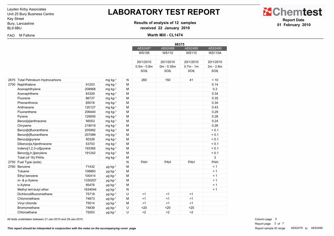
Leyden Kirby Associates
Unit 25 Bury Business Centre
Kay Street
Bury, Lancashire
BL9 6BU
FAO M Fallone
LABORATORY TEST REPORT Results of analysis of 12 samples
received 22 January 2010
Report Date
01 February 2010
Warth Mill - CL1474
98375AE62487 AE62488 AE62489 AE62490
WS109 WS110 WS110 WS110A
20/1/2010 20/1/2010 20/1/2010 20/1/2010
0.5m - 0.8m 0m - 0.35m 0.7m - 1m 2m - 2.8m
SOIL SOIL SOIL SOIL
2675 Total Petroleum Hydrocarbons mg kg-¹ N 260 150 41 < 10
2700 Naphthalene 91203 mg kg-¹ M 0.14
Acenaphthylene 208968 mg kg-¹ M 0.3
Acenaphthene 83329 mg kg-¹ M 0.34
Fluorene 86737 mg kg-¹ M 0.35
Phenanthrene 85018 mg kg-¹ M 0.34
Anthracene 120127 mg kg-¹ M 0.43
Fluoranthene 206440 mg kg-¹ M 0.29
Pyrene 129000 mg kg-¹ M 0.28
Benzo[a]anthracene 56553 mg kg-¹ M 0.24
Chrysene 218019 mg kg-¹ M 0.26
Benzo[b]fluoranthene 205992 mg kg-¹ M < 0.1
Benzo[k]fluoranthene 207089 mg kg-¹ M < 0.1
Benzo[a]pyrene 50328 mg kg-¹ M < 0.1
Dibenzo[a,h]anthracene 53703 mg kg-¹ M < 0.1
Indeno[1,2,3-cd]pyrene 193395 mg kg-¹ M < 0.1
Benzo[g,h,i]perylene 191242 mg kg-¹ M < 0.1
Total (of 16) PAHs mg kg-¹ M 3
2750 Fuel Type (soils) N PAH PAH PAH PAH
2760 Benzene 71432 µg kg-¹ M < 1
Toluene 108883 µg kg-¹ M < 1
Ethyl benzene 100414 µg kg-¹ M < 1
m- & p-Xylene 1330207 µg kg-¹ M < 1
o-Xylene 95476 µg kg-¹ M < 1
Methyl tert-butyl ether 1634044 µg kg-¹ N < 1
Dichlorodifluoromethane 75718 µg kg-¹ U <1 <1 <1
Chloromethane 74873 µg kg-¹ M <1 <1 <1
Vinyl chloride 75014 µg kg-¹ M <1 <1 <1
Bromomethane 74839 µg kg-¹ U <20 <20 <20
Chloroethane 75003 µg kg-¹ U <2 <2 <2
All tests undertaken between 21-Jan-2010 and 29-Jan-2010 2
7ofReport page
This report should be interpreted in conjunction with the notes on the accompanying cover page
2
Column page
AE62479 AE62490toReport sample ID range

Leyden Kirby Associates
Unit 25 Bury Business Centre
Kay Street
Bury, Lancashire
BL9 6BU
FAO M Fallone
LABORATORY TEST REPORT Results of analysis of 12 samples
received 22 January 2010
Report Date
01 February 2010
Warth Mill - CL1474
98375AE62479 AE62480 AE62481 AE62482 AE62483 AE62484 AE62485 AE62486
WS101 WS102 WS103 WS104 WS104 WS105 WS106 WS107
20/1/2010 20/1/2010 20/1/2010 20/1/2010 20/1/2010 20/1/2010 20/1/2010 20/1/2010
0.3m - 0.5m 0m - 0.5m 0.5m - 1m 0.1m - 0.4m 1.2m - 2.7m 0.3m - 1m 0.4m - 1m 0.5m - 0.75m
SOIL SOIL SOIL SOIL SOIL SOIL SOIL SOIL
2760 Trichlorofluoromethane 75694 µg kg-¹ U <1 <1 <1
1,1-Dichloroethene 75354 µg kg-¹ U <1 <1 <1
Dichloromethane 75092 µg kg-¹ U ne ne ne
trans-1,2-Dichloroethene 156605 µg kg-¹ M <1 <1 <1
1,1-Dichloroethane 75343 µg kg-¹ M <1 <1 <1
cis-1,2-Dichloroethene 156592 µg kg-¹ M <1 <1 <1
Bromochloromethane 74975 µg kg-¹ U <1 <1 <1
Trichloromethane 67663 µg kg-¹ M <1 <1 <1
1,1,1-Trichloroethane 71556 µg kg-¹ M <1 <1 <1
Tetrachloromethane 56235 µg kg-¹ M <1 <1 <1
1,1-Dichloropropene 563586 µg kg-¹ U <1 <1 <1
Benzene 71432 µg kg-¹ M <1 <1 25
1,2-Dichloroethane 107062 µg kg-¹ M <2 <2 <2
Trichloroethene 79016 µg kg-¹ M <1 3.5 <1
1,2-Dichloropropane 78875 µg kg-¹ U <1 <1 <1
Dibromomethane 74953 µg kg-¹ U <10 <10 <10
Bromodichloromethane 75274 µg kg-¹ U <5 <5 <5
cis-1,3-Dichloropropene 10061015 µg kg-¹ U <10 <10 <10
Toluene 108883 µg kg-¹ M <1 <1 <1
trans-1,3-Dichloropropene 10061026 µg kg-¹ U <10 <10 <10
1,1,2-Trichloroethane 79005 µg kg-¹ M <10 <10 <10
Tetrachloroethene 127184 µg kg-¹ M <1 <1 <1
1,3-Dichloropropane 142289 µg kg-¹ U <2 <2 <2
Dibromochloromethane 124481 µg kg-¹ U <10 <10 <10
1,2-Dibromoethane 106934 µg kg-¹ U <5 <5 <5
Chlorobenzene 108907 µg kg-¹ M <1 <1 <1
1,1,1,2-Tetrachloroethane 630206 µg kg-¹ M <2 <2 <2
Ethylbenzene 100414 µg kg-¹ M <1 <1 <1
m- & p-Xylene 1330207 µg kg-¹ M <1 <1 <1
o-Xylene 95476 µg kg-¹ M <1 <1 <1
All tests undertaken between 21-Jan-2010 and 29-Jan-2010 1
7ofReport page
This report should be interpreted in conjunction with the notes on the accompanying cover page
3
Column page
AE62479 AE62490toReport sample ID range
* Accreditation status

Leyden Kirby Associates
Unit 25 Bury Business Centre
Kay Street
Bury, Lancashire
BL9 6BU
FAO M Fallone
LABORATORY TEST REPORT Results of analysis of 12 samples
received 22 January 2010
Report Date
01 February 2010
Warth Mill - CL1474
98375AE62487 AE62488 AE62489 AE62490
WS109 WS110 WS110 WS110A
20/1/2010 20/1/2010 20/1/2010 20/1/2010
0.5m - 0.8m 0m - 0.35m 0.7m - 1m 2m - 2.8m
SOIL SOIL SOIL SOIL
2760 Trichlorofluoromethane 75694 µg kg-¹ U <1 <1 <1
1,1-Dichloroethene 75354 µg kg-¹ U <1 <1 <1
Dichloromethane 75092 µg kg-¹ U ne ne ne
trans-1,2-Dichloroethene 156605 µg kg-¹ M <1 <1 <1
1,1-Dichloroethane 75343 µg kg-¹ M <1 <1 <1
cis-1,2-Dichloroethene 156592 µg kg-¹ M <1 <1 <1
Bromochloromethane 74975 µg kg-¹ U <1 <1 <1
Trichloromethane 67663 µg kg-¹ M <1 <1 <1
1,1,1-Trichloroethane 71556 µg kg-¹ M <1 <1 <1
Tetrachloromethane 56235 µg kg-¹ M <1 <1 <1
1,1-Dichloropropene 563586 µg kg-¹ U <1 <1 <1
Benzene 71432 µg kg-¹ M 2 3.3 <1
1,2-Dichloroethane 107062 µg kg-¹ M <2 <2 <2
Trichloroethene 79016 µg kg-¹ M <1 <1 <1
1,2-Dichloropropane 78875 µg kg-¹ U <1 <1 <1
Dibromomethane 74953 µg kg-¹ U <10 <10 <10
Bromodichloromethane 75274 µg kg-¹ U <5 <5 <5
cis-1,3-Dichloropropene 10061015 µg kg-¹ U <10 <10 <10
Toluene 108883 µg kg-¹ M <1 14 <1
trans-1,3-Dichloropropene 10061026 µg kg-¹ U <10 <10 <10
1,1,2-Trichloroethane 79005 µg kg-¹ M <10 <10 <10
Tetrachloroethene 127184 µg kg-¹ M <1 <1 <1
1,3-Dichloropropane 142289 µg kg-¹ U <2 <2 <2
Dibromochloromethane 124481 µg kg-¹ U <10 <10 <10
1,2-Dibromoethane 106934 µg kg-¹ U <5 <5 <5
Chlorobenzene 108907 µg kg-¹ M <1 <1 <1
1,1,1,2-Tetrachloroethane 630206 µg kg-¹ M <2 <2 <2
Ethylbenzene 100414 µg kg-¹ M <1 <1 <1
m- & p-Xylene 1330207 µg kg-¹ M 1.9 <1 <1
o-Xylene 95476 µg kg-¹ M <1 <1 <1
All tests undertaken between 21-Jan-2010 and 29-Jan-2010 2
7ofReport page
This report should be interpreted in conjunction with the notes on the accompanying cover page
3
Column page
AE62479 AE62490toReport sample ID range

Leyden Kirby Associates
Unit 25 Bury Business Centre
Kay Street
Bury, Lancashire
BL9 6BU
FAO M Fallone
LABORATORY TEST REPORT Results of analysis of 12 samples
received 22 January 2010
Report Date
01 February 2010
Warth Mill - CL1474
98375AE62479 AE62480 AE62481 AE62482 AE62483 AE62484 AE62485 AE62486
WS101 WS102 WS103 WS104 WS104 WS105 WS106 WS107
20/1/2010 20/1/2010 20/1/2010 20/1/2010 20/1/2010 20/1/2010 20/1/2010 20/1/2010
0.3m - 0.5m 0m - 0.5m 0.5m - 1m 0.1m - 0.4m 1.2m - 2.7m 0.3m - 1m 0.4m - 1m 0.5m - 0.75m
SOIL SOIL SOIL SOIL SOIL SOIL SOIL SOIL
2760 Styrene 100425 µg kg-¹ U <1 <1 <1
Tribromomethane 75252 µg kg-¹ U <10 <10 <10
Isopropylbenzene 98828 µg kg-¹ U <1 <1 <1
Bromobenzene 108861 µg kg-¹ U <1 <1 <1
1,1,2,2-Tetrachloroethane 79345 µg kg-¹ M <10 <10 <10
1,2,3-Trichloropropane 96184 µg kg-¹ U <50 <50 <50
n-Propylbenzene 103651 µg kg-¹ U <1 <1 <1
2-Chlorotoluene 95498 µg kg-¹ U <1 <1 <1
1,3,5-Trimethylbenzene 108678 µg kg-¹ U 1.3 <1 <1
4-Chlorotoluene 106434 µg kg-¹ U <1 <1 <1
tert-Butylbenzene 98066 µg kg-¹ U <1 <1 <1
1,2,4-Trimethylbenzene 95636 µg kg-¹ U 2.4 <1 <1
sec-Butylbenzene 135988 µg kg-¹ U <1 <1 <1
1,3-Dichlorobenzene 541731 µg kg-¹ U <1 <1 <1
4-Isopropyltoluene 99876 µg kg-¹ U <1 <1 <1
1,4-Dichlorobenzene 106467 µg kg-¹ U <1 <1 <1
n-Butylbenzene 104518 µg kg-¹ U <1 <1 <1
1,2-Dichlorobenzene 95501 µg kg-¹ U <1 <1 <1
1,2-Dibromo-3-chloropropane 96128 µg kg-¹ U <50 <50 <50
1,2,4-Trichlorobenzene 120821 µg kg-¹ U <1 <1 <1
Hexachlorobutadiene 87683 µg kg-¹ U <1 <1 <1
1,2,3-Trichlorobenzene 87616 µg kg-¹ U <2 <2 <2
Methyl tert-butyl ether 1634044 µg kg-¹ N <1 <1 <1
2790 N-Nitrosodimethylamine 62759 mg kg-¹ N <0.5 <0.5 <0.5
Phenol 108952 mg kg-¹ N <0.5 <0.5 <0.5
bis(2-Chloroethyl)ether 111444 mg kg-¹ N <0.5 <0.5 <0.5
2-Chlorophenol 95578 mg kg-¹ N <0.5 <0.5 <0.5
1,3-Dichlorobenzene 541731 mg kg-¹ N <0.5 <0.5 <0.5
1,4-Dichlorobenzene 106467 mg kg-¹ N <0.5 <0.5 <0.5
1,2-Dichlorobenzene 95501 mg kg-¹ N <0.5 <0.5 <0.5
All tests undertaken between 21-Jan-2010 and 29-Jan-2010 1
7ofReport page
This report should be interpreted in conjunction with the notes on the accompanying cover page
4
Column page
AE62479 AE62490toReport sample ID range
* Accreditation status

Leyden Kirby Associates
Unit 25 Bury Business Centre
Kay Street
Bury, Lancashire
BL9 6BU
FAO M Fallone
LABORATORY TEST REPORT Results of analysis of 12 samples
received 22 January 2010
Report Date
01 February 2010
Warth Mill - CL1474
98375AE62487 AE62488 AE62489 AE62490
WS109 WS110 WS110 WS110A
20/1/2010 20/1/2010 20/1/2010 20/1/2010
0.5m - 0.8m 0m - 0.35m 0.7m - 1m 2m - 2.8m
SOIL SOIL SOIL SOIL
2760 Styrene 100425 µg kg-¹ U <1 <1 <1
Tribromomethane 75252 µg kg-¹ U <10 <10 <10
Isopropylbenzene 98828 µg kg-¹ U <1 <1 <1
Bromobenzene 108861 µg kg-¹ U <1 <1 <1
1,1,2,2-Tetrachloroethane 79345 µg kg-¹ M <10 <10 <10
1,2,3-Trichloropropane 96184 µg kg-¹ U <50 <50 <50
n-Propylbenzene 103651 µg kg-¹ U <1 <1 <1
2-Chlorotoluene 95498 µg kg-¹ U <1 <1 <1
1,3,5-Trimethylbenzene 108678 µg kg-¹ U <1 <1 <1
4-Chlorotoluene 106434 µg kg-¹ U <1 <1 <1
tert-Butylbenzene 98066 µg kg-¹ U <1 <1 <1
1,2,4-Trimethylbenzene 95636 µg kg-¹ U <1 <1 <1
sec-Butylbenzene 135988 µg kg-¹ U <1 <1 <1
1,3-Dichlorobenzene 541731 µg kg-¹ U <1 <1 <1
4-Isopropyltoluene 99876 µg kg-¹ U <1 <1 <1
1,4-Dichlorobenzene 106467 µg kg-¹ U <1 <1 <1
n-Butylbenzene 104518 µg kg-¹ U <1 <1 <1
1,2-Dichlorobenzene 95501 µg kg-¹ U <1 <1 <1
1,2-Dibromo-3-chloropropane 96128 µg kg-¹ U <50 <50 <50
1,2,4-Trichlorobenzene 120821 µg kg-¹ U <1 <1 <1
Hexachlorobutadiene 87683 µg kg-¹ U <1 <1 <1
1,2,3-Trichlorobenzene 87616 µg kg-¹ U <2 <2 <2
Methyl tert-butyl ether 1634044 µg kg-¹ N <1 <1 <1
2790 N-Nitrosodimethylamine 62759 mg kg-¹ N <0.5 <0.5 <0.5
Phenol 108952 mg kg-¹ N <0.5 <0.5 <0.5
bis(2-Chloroethyl)ether 111444 mg kg-¹ N <0.5 <0.5 <0.5
2-Chlorophenol 95578 mg kg-¹ N <0.5 <0.5 <0.5
1,3-Dichlorobenzene 541731 mg kg-¹ N <0.5 <0.5 <0.5
1,4-Dichlorobenzene 106467 mg kg-¹ N <0.5 <0.5 <0.5
1,2-Dichlorobenzene 95501 mg kg-¹ N <0.5 <0.5 <0.5
All tests undertaken between 21-Jan-2010 and 29-Jan-2010 2
7ofReport page
This report should be interpreted in conjunction with the notes on the accompanying cover page
4
Column page
AE62479 AE62490toReport sample ID range

Leyden Kirby Associates
Unit 25 Bury Business Centre
Kay Street
Bury, Lancashire
BL9 6BU
FAO M Fallone
LABORATORY TEST REPORT Results of analysis of 12 samples
received 22 January 2010
Report Date
01 February 2010
Warth Mill - CL1474
98375AE62479 AE62480 AE62481 AE62482 AE62483 AE62484 AE62485 AE62486
WS101 WS102 WS103 WS104 WS104 WS105 WS106 WS107
20/1/2010 20/1/2010 20/1/2010 20/1/2010 20/1/2010 20/1/2010 20/1/2010 20/1/2010
0.3m - 0.5m 0m - 0.5m 0.5m - 1m 0.1m - 0.4m 1.2m - 2.7m 0.3m - 1m 0.4m - 1m 0.5m - 0.75m
SOIL SOIL SOIL SOIL SOIL SOIL SOIL SOIL
2790 2-Methylphenol 95487 mg kg-¹ N <0.5 <0.5 <0.5
bis(2-Chloroisopropyl)ether 108601 mg kg-¹ N <0.5 <0.5 <0.5
4-Methylphenol 106445 mg kg-¹ N <0.5 <0.5 <0.5
N-Nitrosodi-n-propylamine 621647 mg kg-¹ N <0.5 <0.5 <0.5
Hexachloroethane 67721 mg kg-¹ N <0.5 <0.5 <0.5
Nitrobenzene 98953 mg kg-¹ N <0.5 <0.5 <0.5
Isophorone 78591 mg kg-¹ N <0.5 <0.5 <0.5
2-Nitrophenol 88755 mg kg-¹ N <0.5 <0.5 <0.5
2,4-Dimethylphenol 105679 mg kg-¹ N <0.5 <0.5 <0.5
bis(2-Chloroethoxy)methane 111911 mg kg-¹ N <0.5 <0.5 <0.5
2,4-Dichlorophenol 120832 mg kg-¹ N <0.5 <0.5 <0.5
1,2,4-Trichlorobenzene 120821 mg kg-¹ N <0.5 <0.5 <0.5
Naphthalene 91203 mg kg-¹ N <0.5 <0.5 <0.5
4-Chloroaniline 106478 mg kg-¹ N <0.5 <0.5 <0.5
Hexachlorobutadiene 87683 mg kg-¹ N <0.5 <0.5 <0.5
4-Chloro-3-methylphenol 59507 mg kg-¹ N <0.5 <0.5 <0.5
2-Methylnaphthalene 91576 mg kg-¹ N <0.5 <0.5 <0.5
Hexachlorocyclopentadiene 77474 mg kg-¹ N <0.5 <0.5 <0.5
2,4,6-Trichlorophenol 88062 mg kg-¹ N <0.5 <0.5 <0.5
2,4,5-Trichlorophenol 95954 mg kg-¹ N <0.5 <0.5 <0.5
2-Chloronaphthalene 91587 mg kg-¹ N <0.5 <0.5 <0.5
2-Nitroaniline 88744 mg kg-¹ N <0.5 <0.5 <0.5
Dimethylphthalate 131113 mg kg-¹ N <0.5 <0.5 <0.5
2,6-Dinitrotoluene 606202 mg kg-¹ N <0.5 <0.5 <0.5
Acenaphthylene 208968 mg kg-¹ N <0.5 <0.5 <0.5
3-Nitroaniline 99092 mg kg-¹ N <0.5 <0.5 <0.5
Acenaphthene 83329 mg kg-¹ N <0.5 <0.5 <0.5
Dibenzofuran 132649 mg kg-¹ N <0.5 <0.5 <0.5
2,4-Dinitrotoluene 121142 mg kg-¹ N <0.5 <0.5 <0.5
Diethylphthalate 84662 mg kg-¹ N <0.5 <0.5 <0.5
All tests undertaken between 21-Jan-2010 and 29-Jan-2010 1
7ofReport page
This report should be interpreted in conjunction with the notes on the accompanying cover page
5
Column page
AE62479 AE62490toReport sample ID range
* Accreditation status

Leyden Kirby Associates
Unit 25 Bury Business Centre
Kay Street
Bury, Lancashire
BL9 6BU
FAO M Fallone
LABORATORY TEST REPORT Results of analysis of 12 samples
received 22 January 2010
Report Date
01 February 2010
Warth Mill - CL1474
98375AE62487 AE62488 AE62489 AE62490
WS109 WS110 WS110 WS110A
20/1/2010 20/1/2010 20/1/2010 20/1/2010
0.5m - 0.8m 0m - 0.35m 0.7m - 1m 2m - 2.8m
SOIL SOIL SOIL SOIL
2790 2-Methylphenol 95487 mg kg-¹ N <0.5 <0.5 <0.5
bis(2-Chloroisopropyl)ether 108601 mg kg-¹ N <0.5 <0.5 <0.5
4-Methylphenol 106445 mg kg-¹ N <0.5 <0.5 <0.5
N-Nitrosodi-n-propylamine 621647 mg kg-¹ N <0.5 <0.5 <0.5
Hexachloroethane 67721 mg kg-¹ N <0.5 <0.5 <0.5
Nitrobenzene 98953 mg kg-¹ N <0.5 <0.5 <0.5
Isophorone 78591 mg kg-¹ N <0.5 <0.5 <0.5
2-Nitrophenol 88755 mg kg-¹ N <0.5 <0.5 <0.5
2,4-Dimethylphenol 105679 mg kg-¹ N <0.5 <0.5 <0.5
bis(2-Chloroethoxy)methane 111911 mg kg-¹ N <0.5 <0.5 <0.5
2,4-Dichlorophenol 120832 mg kg-¹ N <0.5 <0.5 <0.5
1,2,4-Trichlorobenzene 120821 mg kg-¹ N <0.5 <0.5 <0.5
Naphthalene 91203 mg kg-¹ N <0.5 <0.5 <0.5
4-Chloroaniline 106478 mg kg-¹ N <0.5 <0.5 <0.5
Hexachlorobutadiene 87683 mg kg-¹ N <0.5 <0.5 <0.5
4-Chloro-3-methylphenol 59507 mg kg-¹ N <0.5 <0.5 <0.5
2-Methylnaphthalene 91576 mg kg-¹ N <0.5 <0.5 <0.5
Hexachlorocyclopentadiene 77474 mg kg-¹ N <0.5 <0.5 <0.5
2,4,6-Trichlorophenol 88062 mg kg-¹ N <0.5 <0.5 <0.5
2,4,5-Trichlorophenol 95954 mg kg-¹ N <0.5 <0.5 <0.5
2-Chloronaphthalene 91587 mg kg-¹ N <0.5 <0.5 <0.5
2-Nitroaniline 88744 mg kg-¹ N <0.5 <0.5 <0.5
Dimethylphthalate 131113 mg kg-¹ N <0.5 <0.5 <0.5
2,6-Dinitrotoluene 606202 mg kg-¹ N <0.5 <0.5 <0.5
Acenaphthylene 208968 mg kg-¹ N <0.5 1.2 <0.5
3-Nitroaniline 99092 mg kg-¹ N <0.5 <0.5 <0.5
Acenaphthene 83329 mg kg-¹ N 0.84 <0.5 <0.5
Dibenzofuran 132649 mg kg-¹ N <0.5 <0.5 <0.5
2,4-Dinitrotoluene 121142 mg kg-¹ N <0.5 <0.5 <0.5
Diethylphthalate 84662 mg kg-¹ N <0.5 <0.5 <0.5
All tests undertaken between 21-Jan-2010 and 29-Jan-2010 2
7ofReport page
This report should be interpreted in conjunction with the notes on the accompanying cover page
5
Column page
AE62479 AE62490toReport sample ID range

Leyden Kirby Associates
Unit 25 Bury Business Centre
Kay Street
Bury, Lancashire
BL9 6BU
FAO M Fallone
LABORATORY TEST REPORT Results of analysis of 12 samples
received 22 January 2010
Report Date
01 February 2010
Warth Mill - CL1474
98375AE62479 AE62480 AE62481 AE62482 AE62483 AE62484 AE62485 AE62486
WS101 WS102 WS103 WS104 WS104 WS105 WS106 WS107
20/1/2010 20/1/2010 20/1/2010 20/1/2010 20/1/2010 20/1/2010 20/1/2010 20/1/2010
0.3m - 0.5m 0m - 0.5m 0.5m - 1m 0.1m - 0.4m 1.2m - 2.7m 0.3m - 1m 0.4m - 1m 0.5m - 0.75m
SOIL SOIL SOIL SOIL SOIL SOIL SOIL SOIL
2790 Fluorene 86737 mg kg-¹ N <0.5 <0.5 <0.5
4-Chlorophenylether 7005723 mg kg-¹ N <0.5 <0.5 <0.5
4-Nitroaniline 100016 mg kg-¹ N <0.5 <0.5 <0.5
2-Methyl-4,6-dinitrophenol 534521 mg kg-¹ N <0.5 <0.5 <0.5
Azobenzene 103333 mg kg-¹ N <0.5 <0.5 <0.5
4-Bromophenylphenylether 101553 mg kg-¹ N <0.5 <0.5 <0.5
Hexachlorobenzene 118741 mg kg-¹ N <0.5 <0.5 <0.5
Pentachlorophenol 87865 mg kg-¹ N <0.5 <0.5 <0.5
Phenanthrene 85018 mg kg-¹ N 2.2 <0.5 <0.5
Anthracene 120127 mg kg-¹ N <0.5 <0.5 <0.5
Carbazole 86748 mg kg-¹ N <0.5 <0.5 <0.5
Di-n-butylphthalate 84742 mg kg-¹ N <0.5 <0.5 <0.5
Fluoranthene 206440 mg kg-¹ N 5.8 <0.5 <0.5
Pyrene 129000 mg kg-¹ N 5.5 <0.5 <0.5
Butylbenzylphthalate 85687 mg kg-¹ N <0.5 <0.5 <0.5
Benzo[a]anthracene 56553 mg kg-¹ N 3.0 <0.5 <0.5
Chrysene 218019 mg kg-¹ N 2.7 <0.5 <0.5
bis(2-Ethylhexyl)phthalate 117817 mg kg-¹ N 3.7 <0.5 <0.5
Di-n-octylphthalate 117840 mg kg-¹ N <0.5 <0.5 <0.5
Benzo[b]fluoranthene 205992 mg kg-¹ N 3.6 <0.5 <0.5
Benzo[k]fluoranthene 207089 mg kg-¹ N 1.1 <0.5 <0.5
Benzo[a]pyrene 50328 mg kg-¹ N 2.2 <0.5 <0.5
Indeno[1,2,3-cd]pyrene 193395 mg kg-¹ N 1.2 <0.5 <0.5
Dibenzo[a,h]anthracene 53703 mg kg-¹ N <0.5 <0.5 <0.5
Benzo[g,h,i]perylene 191242 mg kg-¹ N 1.5 <0.5 <0.5
2920 Phenols (total) mg kg-¹ N <0.3 <0.3 <0.3 <0.3 <0.3 <0.3 <0.3 <0.3
2010 pH - M 7.7 7.4 8.0 6.7 7.2 7.3 7.7 7.5
2030 Moisture % n/a 19.7 12.4 19.5 23.1 25.4 21.8 19.3 29
Stones content (>50mm) % n/a <0.02 <0.02 <0.02 <0.02 <0.02 <0.02 <0.02 <0.02
2140 Soil colour n/a brown brown brown brown brown brown brown brown
All tests undertaken between 21-Jan-2010 and 29-Jan-2010 1
7ofReport page
This report should be interpreted in conjunction with the notes on the accompanying cover page
6
Column page
AE62479 AE62490toReport sample ID range
* Accreditation status

Leyden Kirby Associates
Unit 25 Bury Business Centre
Kay Street
Bury, Lancashire
BL9 6BU
FAO M Fallone
LABORATORY TEST REPORT Results of analysis of 12 samples
received 22 January 2010
Report Date
01 February 2010
Warth Mill - CL1474
98375AE62487 AE62488 AE62489 AE62490
WS109 WS110 WS110 WS110A
20/1/2010 20/1/2010 20/1/2010 20/1/2010
0.5m - 0.8m 0m - 0.35m 0.7m - 1m 2m - 2.8m
SOIL SOIL SOIL SOIL
2790 Fluorene 86737 mg kg-¹ N 0.55 <0.5 <0.5
4-Chlorophenylether 7005723 mg kg-¹ N <0.5 <0.5 <0.5
4-Nitroaniline 100016 mg kg-¹ N <0.5 <0.5 <0.5
2-Methyl-4,6-dinitrophenol 534521 mg kg-¹ N <0.5 <0.5 <0.5
Azobenzene 103333 mg kg-¹ N <0.5 <0.5 <0.5
4-Bromophenylphenylether 101553 mg kg-¹ N <0.5 <0.5 <0.5
Hexachlorobenzene 118741 mg kg-¹ N <0.5 <0.5 <0.5
Pentachlorophenol 87865 mg kg-¹ N <0.5 <0.5 <0.5
Phenanthrene 85018 mg kg-¹ N 5.9 6.5 <0.5
Anthracene 120127 mg kg-¹ N 1.6 0.74 <0.5
Carbazole 86748 mg kg-¹ N 0.5 0.50 <0.5
Di-n-butylphthalate 84742 mg kg-¹ N <0.5 <0.5 <0.5
Fluoranthene 206440 mg kg-¹ N 15 15 0.63
Pyrene 129000 mg kg-¹ N 13 14 0.71
Butylbenzylphthalate 85687 mg kg-¹ N <0.5 <0.5 <0.5
Benzo[a]anthracene 56553 mg kg-¹ N 7.2 5.8 <0.5
Chrysene 218019 mg kg-¹ N 7.7 5.2 <0.5
bis(2-Ethylhexyl)phthalate 117817 mg kg-¹ N 280 11 <0.5
Di-n-octylphthalate 117840 mg kg-¹ N 0.51 <0.5 <0.5
Benzo[b]fluoranthene 205992 mg kg-¹ N 9.3 7.5 <0.5
Benzo[k]fluoranthene 207089 mg kg-¹ N 2.6 2.1 <0.5
Benzo[a]pyrene 50328 mg kg-¹ N 6.8 6.8 <0.5
Indeno[1,2,3-cd]pyrene 193395 mg kg-¹ N 3.3 3.6 <0.5
Dibenzo[a,h]anthracene 53703 mg kg-¹ N 0.95 0.7 <0.5
Benzo[g,h,i]perylene 191242 mg kg-¹ N 4.1 4.6 <0.5
2920 Phenols (total) mg kg-¹ N <0.3 <0.3 <0.3 <0.3
2010 pH - M 7.5 7.6 6.9 7.1
2030 Moisture % n/a 31.2 20.5 26.7 25.8
Stones content (>50mm) % n/a <0.02 <0.02 <0.02 <0.02
2140 Soil colour n/a brown brown brown brown
All tests undertaken between 21-Jan-2010 and 29-Jan-2010 2
7ofReport page
This report should be interpreted in conjunction with the notes on the accompanying cover page
6
Column page
AE62479 AE62490toReport sample ID range

Leyden Kirby Associates
Unit 25 Bury Business Centre
Kay Street
Bury, Lancashire
BL9 6BU
FAO M Fallone
LABORATORY TEST REPORT Results of analysis of 12 samples
received 22 January 2010
Report Date
01 February 2010
Warth Mill - CL1474
98375AE62479 AE62480 AE62481 AE62482 AE62483 AE62484 AE62485 AE62486
WS101 WS102 WS103 WS104 WS104 WS105 WS106 WS107
20/1/2010 20/1/2010 20/1/2010 20/1/2010 20/1/2010 20/1/2010 20/1/2010 20/1/2010
0.3m - 0.5m 0m - 0.5m 0.5m - 1m 0.1m - 0.4m 1.2m - 2.7m 0.3m - 1m 0.4m - 1m 0.5m - 0.75m
SOIL SOIL SOIL SOIL SOIL SOIL SOIL SOIL
2140 Soil texture n/a sand sand sand sand clay clay clay clay
Other material n/a stones stones stones stones none none none none
2186 Asbestos Containing Material - N not found not found not found not found not found not found not found not found
All tests undertaken between 21-Jan-2010 and 29-Jan-2010 1
7ofReport page
This report should be interpreted in conjunction with the notes on the accompanying cover page
7
Column page
AE62479 AE62490toReport sample ID range
* Accreditation status

Leyden Kirby Associates
Unit 25 Bury Business Centre
Kay Street
Bury, Lancashire
BL9 6BU
FAO M Fallone
LABORATORY TEST REPORT Results of analysis of 12 samples
received 22 January 2010
Report Date
01 February 2010
Warth Mill - CL1474
98375AE62487 AE62488 AE62489 AE62490
WS109 WS110 WS110 WS110A
20/1/2010 20/1/2010 20/1/2010 20/1/2010
0.5m - 0.8m 0m - 0.35m 0.7m - 1m 2m - 2.8m
SOIL SOIL SOIL SOIL
2140 Soil texture n/a clay clay clay clay
Other material n/a none none none none
2186 Asbestos Containing Material - N not found not found not found not found
All tests undertaken between 21-Jan-2010 and 29-Jan-2010 2
7ofReport page
This report should be interpreted in conjunction with the notes on the accompanying cover page
7
Column page
AE62479 AE62490toReport sample ID range


Leyden Kirby Associates
Unit 25 Bury Business Centre
Kay Street
Bury, Lancashire
BL9 6BU
FAO Michelle Fallone
LABORATORY TEST REPORT Results of analysis of 4 samples
received 05 February 2010
Report Date
15 February 2010
Warth Mill - CL1474
86565AE67073 AE67074 AE67075 AE67076
WS101 WS105 WS107 WS110
0.3m - 0.5m 0.3m - 1m 0.5m - 0.7m 0m - 0.35m
LEACHATE LEACHATE LEACHATE LEACHATE
1010 pH PH - U 8.5 7.8 7.8 6.8
1300 Cyanide (total) 57125 mg l-¹ U < 0.05 < 0.05 < 0.05 < 0.05
Cyanide (free) 57125 mg l-¹ U < 0.05 < 0.05 < 0.05 < 0.05
1270 Hardness HARD_TO
T
mg CaCO3 l-¹ U 28 53 21 <15
1220 Sulfate 14808798 mg l-¹ U < 1.0 11 9.7 35
1450 Arsenic 7440382 µg l-¹ U 7.4 2.2 <1.0 1.1
Boron 7440428 µg l-¹ U <20 <20 23 23
Cadmium 7440439 µg l-¹ U <0.080 <0.080 <0.080 <0.080
Chromium (total) 7440473 µg l-¹ U 1.9 6.6 <1.0 <1.0
Copper 7440508 µg l-¹ U 66 16 4.5 5.4
Mercury 7439976 µg l-¹ U <0.50 <0.50 <0.50 <0.50
Nickel 7440020 µg l-¹ U <1.0 <1.0 <1.0 <1.0
Lead 7439921 µg l-¹ U 36 5.5 3.2 9.2
Selenium 7782492 µg l-¹ U <1.0 1.0 <1.0 <1.0
Zinc 7440666 µg l-¹ U 18 2.1 <1.0 17
1490 Chromium (hexavalent) 18540299 µg l-¹ N <50 <50 <50 <50
1675 TPH aliphatic >C5-C6 µg l-¹ N <0.1 <0.1 <0.1 <0.1
TPH aliphatic >C6-C8 µg l-¹ N <0.1 <0.1 <0.1 <0.1
TPH aliphatic >C8-C10 µg l-¹ N <0.1 <0.1 <0.1 <0.1
TPH aliphatic >C10-C12 µg l-¹ N <0.1 <0.1 <0.1 <0.1
TPH aliphatic >C12-C16 µg l-¹ N <0.1 <0.1 <0.1 <0.1
TPH aliphatic >C16-C21 µg l-¹ N <0.1 <0.1 <0.1 <0.1
TPH aliphatic >C21-C35 µg l-¹ N <0.1 <0.1 <0.1 <0.1
TPH aromatic >C5-C7 µg l-¹ N <0.1 <0.1 0.8 <0.1
TPH aromatic >C7-C8 µg l-¹ N <0.1 <0.1 <0.1 <0.1
TPH aromatic >C8-C10 µg l-¹ N <0.1 <0.1 <0.1 <0.1
TPH aromatic >C10-C12 µg l-¹ N <0.1 <0.1 <0.1 <0.1
TPH aromatic >C12-C16 µg l-¹ N 2.8 <0.1 <0.1 <0.1
TPH aromatic >C16-C21 µg l-¹ N 5.8 <0.1 <0.1 <0.1
TPH aromatic >C21-C35 µg l-¹ N 10 <0.1 <0.1 <0.1
Total Petroleum Hydrocarbons µg l-¹ N 19 <10 <10 <10
Login Batch No
Chemtest LIMS ID
Sample ID
Sample No
Depth
SOPi
Matrix
Determinandi CAS Noi Unitsi *
All tests undertaken between 10-Feb-2010 and 15-Feb-2010 1
2ofReport page
This report should be interpreted in conjunction with the notes on the accompanying cover page
1
Column page
AE67073 AE67076toReport sample ID range
* Accreditation status

Leyden Kirby Associates
Unit 25 Bury Business Centre
Kay Street
Bury, Lancashire
BL9 6BU
FAO Michelle Fallone
LABORATORY TEST REPORT Results of analysis of 4 samples
received 05 February 2010
Report Date
15 February 2010
Warth Mill - CL1474
86565AE67073 AE67074 AE67075 AE67076
WS101 WS105 WS107 WS110
0.3m - 0.5m 0.3m - 1m 0.5m - 0.7m 0m - 0.35m
LEACHATE LEACHATE LEACHATE LEACHATE
1700 Naphthalene 91203 µg l-¹ N 0.43 <0.01 <0.01 <0.01
Acenaphthylene 208968 µg l-¹ N <0.01 <0.01 <0.01 <0.01
Acenaphthene 83329 µg l-¹ N <0.01 <0.01 <0.01 <0.01
Fluorene 86737 µg l-¹ N 0.31 <0.01 <0.01 <0.01
Phenanthrene 85018 µg l-¹ N 1.1 <0.01 <0.01 <0.01
Anthracene 120127 µg l-¹ N 0.19 <0.01 <0.01 <0.01
Fluoranthene 206440 µg l-¹ N 1.6 0.63 <0.01 <0.01
Pyrene 129000 µg l-¹ N 1.5 0.42 <0.01 <0.01
Benzo[a]anthracene 56553 µg l-¹ N 0.74 <0.01 <0.01 <0.01
Chrysene 218019 µg l-¹ N 0.82 <0.01 <0.01 <0.01
Benzo[b]fluoranthene 205992 µg l-¹ N 2.6 <0.01 <0.01 <0.01
Benzo[k]fluoranthene 207089 µg l-¹ N 2.5 <0.01 <0.01 <0.01
Benzo[a]pyrene 50328 µg l-¹ N 0.73 <0.01 <0.01 <0.01
Dibenzo[a,h]anthracene 53703 µg l-¹ N 0.77 <0.01 <0.01 <0.01
Indeno[1,2,3-cd]pyrene 193395 µg l-¹ N 0.6 <0.01 <0.01 <0.01
Benzo[g,h,i]perylene 191242 µg l-¹ N 0.55 <0.01 <0.01 <0.01
Total (of 16) PAHs µg l-¹ N 14.44 1.05 <0.2 <0.2
1750 Fuel Type (waters) n/a N/A N/A N/A N/A
1760 Benzene 71432 µg l-¹ U < 1 < 1 1.9 < 1
Toluene 108883 µg l-¹ U < 1 < 1 < 1 < 1
Ethyl benzene 100414 µg l-¹ U < 1 < 1 < 1 < 1
m- & p-Xylene 1330207 µg l-¹ U < 1 < 1 < 1 < 1
o-Xylene 95476 µg l-¹ U < 1 < 1 < 1 < 1
Methyl tert-butyl ether 1634044 µg l-¹ N < 1 < 1 < 1 < 1
1920 Phenols (total) mg l-¹ N < 0.03 < 0.03 < 0.03 < 0.03
All tests undertaken between 10-Feb-2010 and 15-Feb-2010 1
2ofReport page
This report should be interpreted in conjunction with the notes on the accompanying cover page
2
Column page
AE67073 AE67076toReport sample ID range
* Accreditation status

John Walsh Land at Warth Mill, Waterfoot
LK Consult Ltd April 2010 Ref: CL-602-CL1474-02 [R1]
APPENDIX C
GAS MONITORING RESULTS

LK Consult Landfill Gas Monitoring
Site: Warth MillWeather: Overcast, raining, windyGround conditions: WetOperator: CL Instruments: GA2000 & internal flow pod, dipmeter
ID DATE CH4 CO2 O2 BALANCE CH4 %LEL PEAKCH4 BARO REL.PRESSURE INTERNAL FLOW CO H2S CH4/CO2 Res Nitrogen Dipmeter Depth of borehole% % % % % % mb mb l/h ppm ppm % % m m
WS102 02/02/2010 10:56 0 0.2 20.6 79.2 0 0 975 -0.2 0 0 0 0 1.33 Dry 1.9WS106 02/02/2010 11:01 0 7.6 14.8 77.6 0 0 975 -0.17 0 0 0 0 21.66 2 2.1WS107 02/02/2010 11:07 0 0.2 20.8 79 0 0 975 -0.17 0 0 0 0 0.38 1.65 1.8
WS110A 02/02/2010 11:13 0 2.3 16.8 80.9 0 0 975 -0.15 0 0 0 0 17.4 2.98 3.3

LK Consult Landfill Gas Monitoring
Site: Warth MillWeather: Overcast, windyGround conditions: DryOperator: CL Instruments: GA2000 & internal flow pod, dipmeter
ID DATE CH4 CO2 O2 BALANCE CH4 %LEL PEAKCH4 PEAKCO2 MIN O2 BARO REL.PRESSURE CO H2S FLOW POD CH4/CO2 Res Nitrogen Dipmeter Depth of borehole% % % % % % % % mb mb ppm ppm l/h % % m m
WS102 17/02/2010 10:01 0 0.1 19.6 80.3 0 974 0.09 0 0 0.1 0 6.21 Wet at base 1.9WS106* 17/02/2010 10:20 0 0.8 19.1 80 0.1 1.85 2.1WS107 17/02/2010 09:52 0 0.2 19.3 80.5 0 0 0.2 19.2 974 0.07 0 0 0.3 0 7.55 1.6 1.8
WS110A 17/02/2010 09:47 0 0.1 19.2 80.7 0 0 0.3 18.7 974 0.02 0 0 0.3 0 8.12 2.89 3.3
*Machine didn't save last borehole data so using data recorded from field notebook

LK Consult Landfill Gas Monitoring
Site: Warth MillWeather: Sunny, coldGround conditions: DryOperator: CL Instruments: GA2000 & internal flow pod, dipmeter
ID DATE CH4 CO2 O2 BALANCE CH4 %LEL PEAKCH4 PEAKCO2 MIN O2 BARO REL.PRESSURE CO H2S FLOW POD CH4/CO2 Res Nitrogen Dipmeter Depth of borehole% % % % % % % % mb mb ppm ppm l/h % % m m
WS102 04/03/2010 13:58 0 0 20.2 79.8 0 0 1.9 19 1006 0.3 0 0 0 0 3.44 Wet at base 1.9WS106 04/03/2010 13:52 0 1.9 18.6 79.5 0 0 2.3 18.4 1006 0.14 0 0 0 0 9.19 1.95 2.1WS107 04/03/2010 13:50 0 0.1 20 79.9 0 1006 0.09 2 0 0 0 4.3 1.7 1.8
WS110A 04/03/2010 13:37 0.1 0.2 19.6 80.1 2 1006 0.14 4 0 0 0.5 6.01 2.95 3.3

LK Consult Landfill Gas Monitoring
Site: Warth MillWeather: OvercastGround conditions: DampOperator: CL Instruments: GA2000 & internal flow pod, dipmeter
ID DATE CH4 CO2 O2 BALANCE CH4 %LEL PEAKCH4 PEAKCO2 MIN O2 BARO REL.PRESSURE CO H2S FLOW POD CH4/CO2 Res Nitrogen Depth of Dipmeter Depth of Borehole % % % % % % % % mb mb ppm ppm l/h % % m m
WS102 16/03/2010 13:47 0 0.1 20 79.9 0 0 0.6 19.4 1001 0.27 3 0 -0.2 0 4.3 Wet at base 1.9WS106 16/03/2010 13:42 0 0.5 19.5 80 0 0 2.5 17.7 1001 0.12 5 0 -0.1 0 6.29 1.95 2.1WS107 16/03/2010 13:38 0 0.2 19.9 79.9 0 0 1.1 18.9 1001 0.45 2 0 -0.1 0 4.68 1.75 1.8
WS110A 16/03/2010 13:32 0 1.1 18.7 80.2 0 0 1.1 18.7 1001 -0.16 3 0 -0.2 0 9.51 2.95 3.3

LK Consult Landfill Gas Monitoring
Site: Warth MillWeather: Rain and sleet, windyGround conditions: WetOperator: CL Instruments: GA2000 & internal flow pod, dipmeter
ID DATE CH4 CO2 O2 BALANCE CH4 %LEL PEAKCH4 PEAKCO2 MIN O2 BARO REL.PRESSURE CO H2S FLOW POD CH4/CO2 Res Nitrogen Dipmeter Depth of borehole% % % % % % % % mb mb ppm ppm l/h % % m m
WS102 31/03/2010 15:23 0 0 20.2 79.8 0 0 0.2 19.3 970 0.18 0 0 0 >>>> 3.44 Dry 1.8WS106 31/03/2010 15:17 0 0.1 19.9 80 0 0 1.4 15.1 970 0.1 0 0 0 0 4.78 1.9 2.1WS107 31/03/2010 15:12 0 1.4 14.2 84.4 0 0 1.5 13.7 970 0.1 0 0 -0.2 0 30.72 1.3 1.8
WS110A 31/03/2010 15:05 0 0 20 80 0 0 0.1 19.8 970 0.22 0 0 -0.1 >>>> 4.4 2 3.3

LK Consult Landfill Gas Monitoring
Site: Warth MillWeather: Overcast, DrizzleGround conditions: DryOperator: CL Instruments: GA2000 & internal flow pod, dipmeter
ID DATE CH4 CO2 O2 BALANCE CH4 %LEL PEAKCH4 PEAKCO2 MIN O2 BARO REL.PRESSURE CO H2S FLOW POD Dipmeter Depth of borehole% % % % % % % % mb mb ppm ppm l/h m m
WS102 29/04/2010 09:31 0 0.4 20 80 0 0 2.4 17.8 989 0.05 0 0 0.4 Dry 1.8WS106 29/04/2010 09:25 0 2.3 20.1 79.9 0 0 0.5 19.4 989 0.18 0 3 0.4 2 2.1WS107 29/04/2010 09:20 0 0.5 19.7 80.3 0 0 3.6 15.9 989 0.21 0 2 0.3 1.4 1.8
WS110A 29/04/2010 09:13 0 3.5 20.2 79.7 0 0 0.1 20.2 989 0.09 0 3 0 3 3.3

John Walsh Land at Warth Mill, Waterfoot
LK Consult Ltd April 2010 Ref: CL-602-CL1474-02 [R1]
APPENDIX D
ATRISK VALUES

Residential with the consumption of homegrown produce
Author Atkins
Revision 2
Date 13/05/2009
Title
Compound SSV mg/kg Notes
Arsenic 3.20E+01 Value presented is Environment Agency SGV.
Cadmium 8.59E+00
Chromium 1.47E+01
Nickel 1.30E+02 Value presented is Environment Agency SGV.
Lead 1.68E+02
Lead has been modelled as a threshold substance. Should background exposure not be
taken into account, the SSV would be 322mg/kg.
Mercury - elemental 1.00E+00 Value presented is Environment Agency SGV. Based on inhalation exposure only.
Mercury - inorganic 1.70E+02 Value presented is Environment Agency SGV.
Mercury - methyl 1.10E+01 Value presented is Environment Agency SGV.
Beryllium 6.09E+01
Selenium 3.50E+02 Value presented is Environment Agency SGV.
Vanadium 1.15E+02
Copper 4.02E+03
Zinc 1.72E+04
Antimony 9.97E+01
Acenaphthene 9.37E+02
The value presented is the lower of the aqueous or vapour saturation limits. The inhalation
of vapour pathway contributes less than ten percent of total exposure which is unlikely to
significantly affect the combined assessment criterion. Users may wish to consider using
the combined assessment criterion given by CLEA of 2130 mg/kg if free product is not
observed.
Anthracene 2.09E+01
The value presented is the lower of the aqueous or vapour saturation limits. The inhalation
of vapour pathway contributes less than ten percent of total exposure which is unlikely to
significantly affect the combined assessment criterion. Users may wish to consider using
the combined assessment criterion given by CLEA of 18300 mg/kg if free product is not
observed.
Benzo(a)anthracene 1.03E+01
The value presented is the lower of the aqueous or vapour saturation limits. The inhalation
of vapour pathway contributes less than ten percent of total exposure which is unlikely to
significantly affect the combined assessment criterion. Users may wish to consider using
the combined assessment criterion given by CLEA of 18 mg/kg if free product is not
observed.
Benzo(a)pyrene 2.43E+00
Benzo(b)fluoranthene 7.29E+00
The value presented is the lower of the aqueous or vapour saturation limits. The inhalation
of vapour pathway contributes less than ten percent of total exposure which is unlikely to
significantly affect the combined assessment criterion. Users may wish to consider using
the combined assessment criterion given by CLEA of 24.1 mg/kg if free product is not
observed.
Benzo(g,h,i)perylene 1.12E-01
The value presented is the lower of the aqueous or vapour saturation limits. The inhalation
of vapour pathway contributes less than ten percent of total exposure which is unlikely to
significantly affect the combined assessment criterion. Users may wish to consider using
the combined assessment criterion given by CLEA of 248 mg/kg if free product is not
observed.
Benzo(k)fluoranthene 4.12E+00
The value presented is the lower of the aqueous or vapour saturation limits. The inhalation
of vapour pathway contributes less than ten percent of total exposure which is unlikely to
significantly affect the combined assessment criterion. Users may wish to consider using
the combined assessment criterion given by CLEA of 244 mg/kg if free product is not
observed.
Chrysene 2.64E+00
The value presented is the lower of the aqueous or vapour saturation limits. The inhalation
of vapour pathway contributes less than ten percent of total exposure which is unlikely to
significantly affect the combined assessment criterion. Users may wish to consider using
the combined assessment criterion given by CLEA of 2280 mg/kg if free product is not
observed.
Dibenzo(ah)anthracene 2.36E-02
The value presented is the lower of the aqueous or vapour saturation limits. The inhalation
of vapour pathway contributes less than ten percent of total exposure which is unlikely to
significantly affect the combined assessment criterion. Users may wish to consider using
the combined assessment criterion given by CLEA of 2.4 mg/kg if free product is not
observed.
Fluoranthene 1.13E+02
The value presented is the lower of the aqueous or vapour saturation limits. The inhalation
of vapour pathway contributes less than ten percent of total exposure which is unlikely to
significantly affect the combined assessment criterion. Users may wish to consider using
the combined assessment criterion given by CLEA of 2160 mg/kg if free product is not
observed.
Fluorene 7.46E+02
The value presented is the lower of the aqueous or vapour saturation limits. The inhalation
of vapour pathway contributes less than ten percent of total exposure which is unlikely to
significantly affect the combined assessment criterion. Users may wish to consider using
the combined assessment criterion given by CLEA of 1930 mg/kg if free product is not
observed.
Indeno(1,2,3-cd)pyrene 3.68E-01
The value presented is the lower of the aqueous or vapour saturation limits. The inhalation
of vapour pathway contributes less than ten percent of total exposure which is unlikely to
significantly affect the combined assessment criterion. Users may wish to consider using
the combined assessment criterion given by CLEA of 23.9 mg/kg if free product is not
observed.
SSVs derived using CLEA v1.04 for 6% SOM, Residential with homegrown produce
land use
PLEASE NOTE
These values are provided exclusively for the use of subscribers to www.atrisksoil.co.uk. In accordance with the terms and conditions of the atrisksoil website the
information is for the sole use of the user and by receiving or obtaining any information contained herein the user agrees that at all times they will keep secret and
confidential and shall procure and safeguard that their directors and employees keep secret and confidential all business and trade secrets and any information
of a confidential nature relating to the processes, affairs, methods, and data belonging to Atkins Limited which they may have received or obtained in the
performance of or otherwise as a direct or indirect result of entering into any agreement with Atkins Limited.
Any information contained herein is protected by copyright and other intellectual property laws. Any unauthorized copying, distribution, public display, public
performance [and preparation of derivative works] from any information contained herein are prohibited by copyright law. By using the atrisksoil service the user
represents and warrants that they will not use the services in any manner that would violate any copyright, intellectual property, or any other rights.
CLEA v1.04
April 2009 (updated for March 2009 SGV information)
Confidential
ATRISKsoil

Residential with the consumption of homegrown produce
Author Atkins
Revision 2
Date 13/05/2009
Title
Compound SSV mg/kg Notes
SSVs derived using CLEA v1.04 for 6% SOM, Residential with homegrown produce
land use
PLEASE NOTE
These values are provided exclusively for the use of subscribers to www.atrisksoil.co.uk. In accordance with the terms and conditions of the atrisksoil website the
information is for the sole use of the user and by receiving or obtaining any information contained herein the user agrees that at all times they will keep secret and
confidential and shall procure and safeguard that their directors and employees keep secret and confidential all business and trade secrets and any information
of a confidential nature relating to the processes, affairs, methods, and data belonging to Atkins Limited which they may have received or obtained in the
performance of or otherwise as a direct or indirect result of entering into any agreement with Atkins Limited.
Any information contained herein is protected by copyright and other intellectual property laws. Any unauthorized copying, distribution, public display, public
performance [and preparation of derivative works] from any information contained herein are prohibited by copyright law. By using the atrisksoil service the user
represents and warrants that they will not use the services in any manner that would violate any copyright, intellectual property, or any other rights.
Pyrene 1.32E+01
The value presented is the lower of the aqueous or vapour saturation limits. The inhalation
of vapour pathway contributes less than ten percent of total exposure which is unlikely to
significantly affect the combined assessment criterion. Users may wish to consider using
the combined assessment criterion given by CLEA of 1550 mg/kg if free product is not
observed.
Phenol 1.93E+03
2,3,7,8-tetrachlorodibenzo-p-dioxin 7.66E-05
Naphthalene 8.71E+00
Benzene 3.30E-01 Value presented is Environment Agency SGV.
Toluene 6.10E+02 Value presented is Environment Agency SGV.
Ethylbenzene 3.50E+02 Value presented is Environment Agency SGV.
o-xylene 2.50E+02
Value presented is Environment Agency SGV. Users must consider total exposure from all
xylene isomers and not consider them in isolation.
m-xylene 2.40E+02
Value presented is Environment Agency SGV. Users must consider total exposure from all
xylene isomers and not consider them in isolation.
p-xylene 2.30E+02
Value presented is Environment Agency SGV. Users must consider total exposure from all
xylene isomers and not consider them in isolation.
Trichloroethene 4.93E-01
Vinyl chloride 9.86E-04
1,1,1,2-Tetrachloroethane 4.82E+00
1,1,2,2-Tetrachloroethanes 6.34E+00
Tetrachloroethene 6.15E+00
1,1,1-trichloroethane 2.79E+01
1,2-dichloroethane 1.39E-02
Carbon tetrachloride 8.92E-02
Chlorobenzene (mono) 6.42E+00
Carbon disulphide 8.39E-01
TPH Aromatic C5-C7 (benzene) 3.30E-01
Benzene is the only constituent of this fraction (TPHCWG 1997). Value presented is
Environment Agency SGV.
TPH Aromatic C7-C8 (toluene) 6.10E+02
Toluene is the only constituent of this fraction (TPHCWG 1997). Value presented is
Environment Agency SGV.
TPH Aromatic C8-C10 2.37E+01
TPH Aromatic C10-C12 1.32E+02
TPH Aromatic C12-C16 4.52E+02
TPH Aliphatic C5-C6 2.61E+01
TPH Aliphatic C6-C8 8.78E+01
TPH Aliphatic C8-C10 1.45E+01
TPH Aliphatic C10-C12 8.77E+01
TPH Aliphatic C12-C16 1.26E+02
The saturated soil concentration has been exceeded in the calculation but it will not affect
the significant exposure pathways. The SSV presented is the saturation limit. Users may
wish to consider using the combined assessment criterion calculated using the approach
outlined within SR4, of 4010 mg/kg.
TPH Aromatic C16-C21 8.04E+02
This fraction is not considered volatile and the inhalation of vapour pathways have not
been considered (TPHCWG, 1997).
TPH Aromatic C21-C35 1.22E+03
This fraction is not considered volatile and the inhalation of vapour pathways have not
been considered (TPHCWG, 1997).
TPH Aliphatic C16-C35 8.82E+04
This fraction is not considered volatile and the inhalation of vapour pathways have not
been considered (TPHCWG, 1997).
Cyanide 3.40E+01
Based on acute exposure for a 0-6 year old child, using 5th percentile bodyweight from
CLR10. Information is not available in SR3 and supporting documents regarding the 5th
percentile bodyweight of SR3 bodyweight data. It is not considered likely that new data
would significantly affect the SSV.
CLEA v1.04
April 2009 (updated for March 2009 SGV information)
Confidential
ATRISKsoil


![f - shoei-g.com · 4Ú 6bu 'brb bnb b+b*b b§b·b b¤b_b®bu4Ýb aîbgb¤bt5y$Íb1 "b.be ... ccc_ckcucwczcwchc|cn cjc|cucmcv clczcpcb @ -ð)¡b¶ ]-ð) ...](https://static.fdocuments.in/doc/165x107/5bed36ea09d3f2f51e8bd2be/f-shoei-g-4u-6bu-brb-bnb-bbb-bbb-bbbbu4yb-aibgbbt5yib1.jpg)