Lakes, Ponds and Reservoirs - Missouri Department of ... Ponds and Reservoirs Lakes, ponds and...
4
DNREDU0017 (11/2016) Page 1 Lakes, Ponds and Reservoirs Lakes, ponds and reservoirs are another component of surface water. They all share the characterisc of being essenally non-moving water. These surface waters are highly valuable for their recreaonal features, visual appeal, and water supply capacity. The water they contain is one of the most valued of our natural resources. Another aspect of these water bodies is that they may either occur naturally or be man-made. Naturally occurring lakes and ponds in Missouri include oxbow lakes, and sinkhole ponds. Man-made lakes are constructed by damming rivers or streams. Small ponds are made by holding back surface water runoff in valleys or other low spots in a watershed. The size of these water bodies can be less than an acre or more than 56,000 acres, as in Missouri’s larger reservoirs. While no official disncon between lakes and ponds has been established, these generally accepted definions are helpful for discussion. Ponds have shallow standing water, usually with mud covered booms, in which light penetrates to the boom allowing aquac plants to grow across its enrety. There is lile wave acon and the pond’s water temperature is relavely even throughout and changes with the air temperature. A lake on the other hand has both a shallow shoreline area that may potenally support rooted plant growth and a deeper poron where sunlight does not penetrate to the boom. Lakes are deep enough to have two or three temperature layers throughout the year. This straficaon can cause turnover, explained later in this piece. Lakes and ponds represent essenal habitats and food resources for a diverse array of fish, aquac life, and wildlife. But these ecosystems are fragile and can undergo rapid environmental changes due to alteraons to their watershed or other outside influences such as climate variability. Human acvies, like water extracon or upstream development, can further accelerate the rate of change oſten leading to significant decline in the aquac ecosystem health. However, if the cause of the changes are known, human intervenon can somemes control, or even reverse, the declining condion. Naturally Occurring Lakes and Ponds Oxbow Lakes have mostly formed in Missouri floodplains of the Mississippi, Missouri, Grand and Chariton Rivers. However, with levees constructed for flood control and the two big rivers confined to a central channel, the rivers are now largely separated from their flood plains. Many oxbow lakes have been filled in for agricultural use. Oxbow lakes are typically shallow and don’t have new water flowing in except during larger flood events. An oxbow lake starts out as a curve, or meander, in a river. When a river cuts off a meander in a channel and finds a different, shorter course, the pool leſt behind is an oxbow lake. An oxbow lake gets its name from the U-shaped collar placed around an ox’s neck to which a plow is aached. Oxbow lakes form when a meandering river cuts off a loop of the channel. Table Rock Lake State Park
Transcript of Lakes, Ponds and Reservoirs - Missouri Department of ... Ponds and Reservoirs Lakes, ponds and...
DNREDU0017 (11/2016) Page 1
Lakes, Ponds and Reservoirs
Lakes, ponds and reservoirs are another component of surface water. They all share the characteristic of being essentially non-moving water. These surface waters are highly valuable for their recreational features, visual appeal, and water supply capacity. The water they contain is one of the most valued of our natural resources. Another aspect of these water bodies is that they may either occur naturally or be man-made. Naturally occurring lakes and ponds in Missouri include oxbow lakes, and sinkhole ponds. Man-made lakes are constructed by damming rivers or streams. Small ponds are made by holding back surface water runoff in valleys or other low spots in a watershed. The size of these water bodies can be less than an acre or more than 56,000 acres, as in Missouri’s larger reservoirs. While no official distinction between lakes and ponds has been established, these generally accepted definitions are helpful for discussion. Ponds have shallow standing water, usually with mud covered bottoms, in which light penetrates to the bottom allowing aquatic plants to grow across its entirety. There is little wave action and the pond’s water temperature is relatively even throughout and changes with the air temperature. A lake on the other hand has both a shallow shoreline area that may potentially support rooted plant growth and a deeper portion where sunlight does not penetrate to the bottom. Lakes are deep enough to have two or three temperature layers throughout the year. This stratification can cause turnover, explained later in this piece. Lakes and ponds represent essential habitats and food resources for a diverse array of fish, aquatic life, and wildlife. But these ecosystems are fragile and can undergo rapid environmental changes due to alterations to their watershed or other outside influences such as climate variability. Human activities, like water extraction or upstream
development, can further accelerate the rate of change often leading to significant decline in the aquatic ecosystem health. However, if the cause of the changes are known, human intervention can sometimes control, or even reverse, the declining condition.
Naturally Occurring Lakes and Ponds
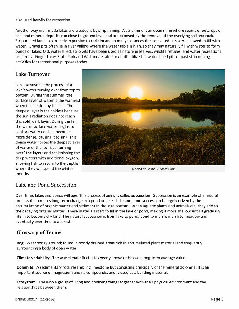
Oxbow Lakes have mostly formed in Missouri floodplains of the Mississippi, Missouri, Grand and Chariton Rivers. However, with levees constructed for flood control and the two big rivers confined to a central channel, the rivers are now largely separated from their flood plains. Many oxbow lakes have been filled in
for agricultural use. Oxbow lakes are typically shallow and don’t have new water flowing in except during larger flood events. An oxbow lake starts out as a curve,
or meander, in a river. When a river cuts off a meander in a channel and finds a different, shorter course, the pool left behind is an oxbow lake. An oxbow lake gets its name from the U-shaped collar placed around an ox’s neck to which a plow is attached.
Oxbow lakes form when a meandering
river cuts off a loop of the channel.
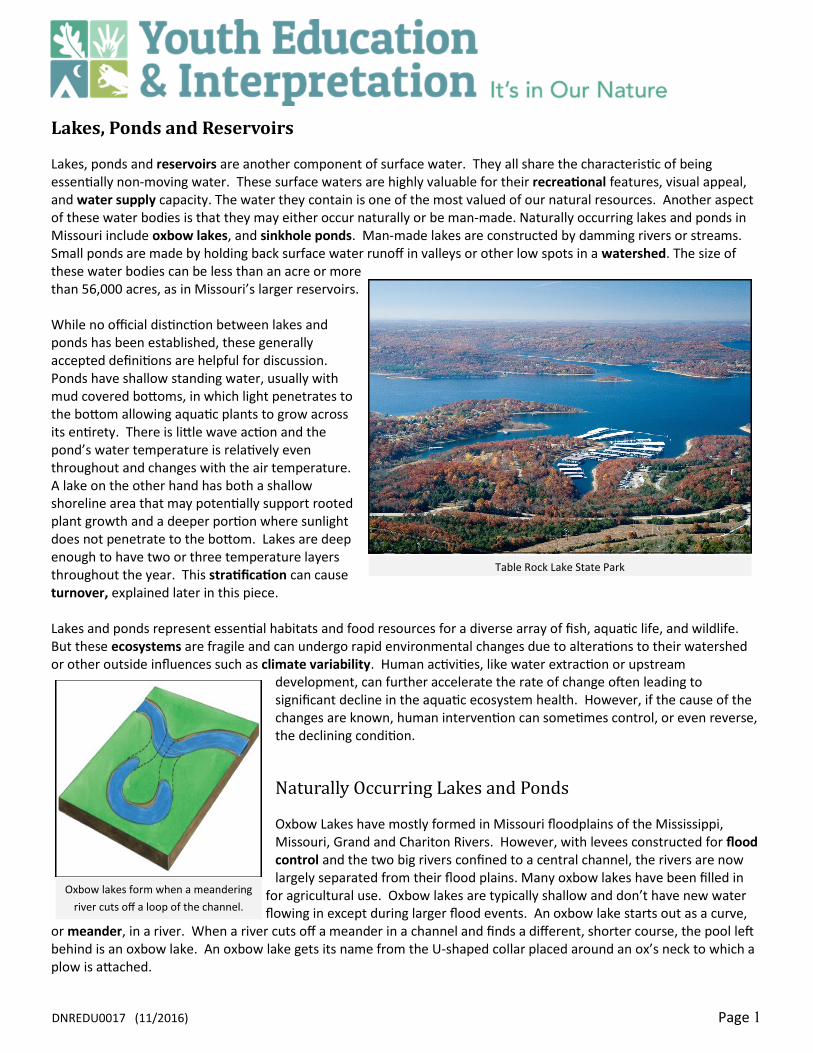
Table Rock Lake State Park

DNREDU0017 (11/2016) Page 2
Oxbow lakes are stillwater lakes. This means that water does not flow into or out of them. There is no stream or spring feeding the lake, and it doesn’t have a natural outlet. Oxbow lakes often become swamps or bogs, and they regularly dry up as their water evaporates. Some of the common uses for oxbow lakes include wetland habitat, waterfowl hunting, fishing, sailing, rowing or boating. A shining example of an oxbow lake can be found at Missouri’s Big Lake State Park. The park was established at the northern end of the state's largest oxbow lake, Big Lake, in Northwest Missouri along the Missouri river.
Pin Oak Slough Natural Area within Knob Noster State Park is another example of an oxbow. This slough was formed from an old cut-off of Clearfork Creek. A slough (pronounced "slew") is typically used to describe wetlands. However, as sloughs form along the edges of rivers where the old channel of the river once flowed, they are also referred to as oxbows because they tend to form at a bend in the old river bed. Pin Oak Slough was designated a Natural Area in 1978. A Natural Area is protected from development and managed to preserve the natural characteristics of the area. In many cases the Natural Area provides essential habitat for rare and endangered plants and animals.
Sinkhole Ponds
Sinkholes form in what geologists call “karst topography.” Karst is a German word used to describe land that is filled with sinkholes, caves, springs, and underground streams. Karst topography is characterized by bedrock that can be dissolved by ground water. Bedrock in a karst area typically is limestone and dolomite. As rain falls, it absorbs carbon dioxide, making percolating water slightly acidic. As this water migrates downward, the bedrock is slowly dissolved, creating underground cavities. Over time the underground void becomes larger as soil and rock from above fall into the cavity and are washed away. Sometimes gradually, and some times in an instant the overlaying material will fall in and a sinkhole forms. Sinkhole ponds form when the bed of the sinkhole is lined with impermeable clay that prevents water from draining. Not all of the soil particles get carried through the water conduit into the underground cavity. If the soil contains a large amount of clay, the water passageway can become plugged and the sinkhole may start to hold water and form a natural sinkhole pond. Several sinkhole ponds can be found at Rock Bridge Memorial State Park as karst topography is prevalent within the area. The natural sinkhole ponds provide aquatic habitat for wetland plants and animals. Two historic sinkhole ponds in the southern Missouri uplands are Tupelo Gum Pond and Cupola Pond. Both of these sinkhole ponds are exceptional as they have water tupelo trees surrounding them. These trees are common in the swamps of the Mississippi delta. The water tupelo trees indicate that both of these sinkhole ponds are ancient. Using dating techniques of pollen found in core samples taken from the ponds’ sediment, scientists estimate that the ponds are at least 20,000 years old! Both of these sinkhole ponds have also been designated as Natural Areas.
Constructed Lakes and Reservoirs
Most lakes and ponds in Missouri are artificial. Constructed lakes are created when rivers and streams are dammed. In addition to many large lakes, there are thousands of small dams impounding lakes and ponds across Missouri, primarily to be used for recreation or agriculture. Reservoirs, also called impoundments, are man-made lakes. Reservoirs are built for many uses. Some are built strictly for recreation (such as fishing and boating) or to control floods. Others are built to store water that may be used for drinking water and irrigation. Hydroelectric dams use the flow of water over turbines to generate electricity. Lake of the Ozarks is one of the more familiar examples of a constructed lake in Missouri. Ameren UE built Bagnell dam to impound the Osage River in order to generate electricity, but the lake is
Strip mine lakes
DNREDU0017 (11/2016) Page 3
also used heavily for recreation. Another way man-made lakes are created is by strip mining. A strip mine is an open mine where seams or outcrops of coal and mineral deposits run close to ground level and are exposed by the removal of the overlying soil and rock. Strip-mined land is extremely expensive to reclaim and in many instances the excavated pits were allowed to fill with water. Gravel pits often lie in river valleys where the water table is high, so they may naturally fill with water to form ponds or lakes. Old, water filled, strip pits have been used as nature preserves, wildlife refuges, and water recreational use areas. Finger Lakes State Park and Wakonda State Park both utilize the water-filled pits of past strip mining activities for recreational purposes today.
Lake Turnover
Lake turnover is the process of a lake's water turning over from top to bottom. During the summer, the surface layer of water is the warmest when it is heated by the sun. The deepest layer is the coldest because the sun's radiation does not reach this cold, dark layer. During the fall, the warm surface water begins to cool. As water cools, it becomes more dense, causing it to sink. This dense water forces the deepest layer of water of the to rise, "turning over" the layers and replenishing the deep waters with additional oxygen, allowing fish to return to the depths where they will spend the winter months.
Lake and Pond Succession
Over time, lakes and ponds will age. This process of aging is called succession. Succession is an example of a natural process that creates long-term change in a pond or lake. Lake and pond succession is largely driven by the accumulation of organic matter and sediment in the lake bottom. When aquatic plants and animals die, they add to the decaying organic matter. These materials start to fill in the lake or pond, making it more shallow until it gradually fills in to become dry land. The natural succession is from lake to pond, pond to marsh, marsh to meadow and eventually over time to a forest.
Glossary of Terms
Bog: Wet spongy ground; found in poorly drained areas rich in accumulated plant material and frequently surrounding a body of open water.
Climate variability: The way climate fluctuates yearly above or below a long-term average value.
Dolomite: A sedimentary rock resembling limestone but consisting principally of the mineral dolomite. It is an important source of magnesium and its compounds, and is used as a building material.
Ecosystem: The whole group of living and nonliving things together with their physical environment and the relationships between them.
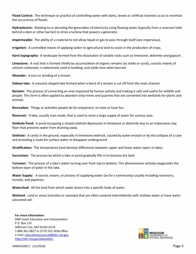
A pond at Route 66 State Park
DNREDU0017 (11/2016) Page 4
For more information: DNR Youth Education and Interpretation P.O. Box 176 Jefferson City, MO 65102-0176 1-800-361-4827 or (573) 522-2656 office e-mail: [email protected] http://dnr.mo.gov/education
Flood Control: The technique or practice of controlling water with dams, levees or artificial channels so as to minimize the occurrence of floods.
Hydroelectric: Relating to or denoting the generation of electricity using flowing water (typically from a reservoir held behind a dam or other barrier) to drive a turbine that powers a generator.
Impermeable: The ability of a material to not allow liquid or gas to pass through itself (see impervious).
Irrigation: A controlled means of applying water to agricultural land to assist in the production of crops.
Karst topography: A landscape formed from the dissolution of soluble rocks such as limestone, dolomite and gypsum.
Limestone: A rock that is formed chiefly by accumulation of organic remains (as shells or coral), consists mainly of calcium carbonate, is extensively used in building, and yields lime when burned.
Meander: A turn or winding of a stream.
Oxbow lake: A crescent-shaped lake formed when a bend of a stream is cut off from the main channel.
Reclaim: The process of converting an area impacted by human activity and making it safe and useful for wildlife and people. This term is often applied to abandon strip mines and quarries that are converted into wetlands for plants and animals.
Recreation: Things or activities people do for enjoyment, to relax or have fun.
Reservoir: A lake, usually man-made, that is used to store a large supply of water for various uses.
Sinkhole Pond: A pond occupying a closed sinkhole depression in limestone or dolomite due to an impervious clay floor that prevents water from draining away.
Sinkhole: A cavity in the ground, especially in limestone bedrock, caused by water erosion or by the collapse of a cave and providing a route for surface water to disappear underground.
Stratification: The temperature (and density) differences between upper and lower water layers in lakes.
Succession: The process by which a lake or pond gradually fills in to become dry land.
Turnover: The process of a lake's water turning over from top to bottom. This phenomenon actively oxygenates the bottom layer of water in the lake.
Water Supply: A source, means, or process of supplying water (as for a community) usually including reservoirs, tunnels, and pipelines.
Watershed: All the land from which water drains into a specific body of water.
Wetland: Land or areas (marshes or swamps) that are often covered intermittently with shallow water or have water saturated soil.