Kington area neighbourhood plan 2019 - Herefordshire Council
118
KINGTON AREA NEIGHBOURHOOD PLAN 2019-2031 Kington Town Kington Rural and Lower Harpton Group Parish Huntington Parish KINGTON AREA NEIGHBOURHOOD PLAN 2019-2031 1
Transcript of Kington area neighbourhood plan 2019 - Herefordshire Council

KINGTON AREA NEIGHBOURHOOD PLAN 2019-2031
Kington Town Kington Rural and Lower Harpton Group Parish
Huntington Parish
KINGTON AREA NEIGHBOURHOOD PLAN 2019-2031
1
Contents Page
1 What is a Neighbourhood Plan 3
2 The Kington Area Neighbourhood Plan 4
3 Aims of the Kington Area Neighbourhood Plan 5
4 Description of the Neighbourhood Plan Area 6
5 Development Requirements 13
6 Kington Area Neighbourhood Plan Local Issues 17
7 Vision Statement 19
8 Kington Area Neighbourhood Plan Objectives 20
9 Kington Neighbourhood Plan Policies 22
KANP ENV 1 A Valued Natural Environment 22 KANP ENV 2 Dark Skies 23 KANP ENV 3 A Valued Built Environment 26 KANP SB1 Settlement Boundaries 29 KANP H1 Housing Delivery Kington Town 36 KANP H2 Housing Delivery Land South of Kington 40 KANP H3 Housing Delivery Kington Rural and 45 Lower Harpton Group Parish KANP H4 Housing Delivery Huntington Parish 49 KANP H5 Housing Design Criteria 50 KANP E1 A Thriving Rural Economy 52 KANP E2 Large Scale Employment Activities 53 KANP KTC 1 Kington Town Centre 57 KANP T1 Sustainable Tourism and Leisure 61 KANP INF1 Local Infrastructure 63 KANP LGS1 Green Spaces 67 KANP G1 Green Infrastructure 68 KANP CF1 Community Facilities 71
10Community Projects 72 11Review and Monitoring the Plan 73
Appendices 75
Photographs by A Compton R Cotterill and JGardner
KINGTON AREA NEIGHBOURHOOD PLAN 2019-2031
2
1 WHAT IS A NEIGHBOURHOOD PLAN
1 In 2011 Parliament agreed the Localism Act which devolved a number of powers to local communities including direct involvement in strategic planning This new power gives communities the opportunity to have more control over planning policy through the production of a Neighbourhood Development Plan (NDP) The Kington Area Neighbourhood Plan (KANP) must be in conformity with Herefordshire Councilrsquos Local Plan the Core Strategy (2011-2031) and with the National Planning Policy Framework (NPPF) The NDP should be acceptable to local people reflecting their needs and priorities and be supported by a local referendum Once adopted it will become part of the Countyrsquos development framework and all development proposals will need to conform to KANP Policies
KINGTON AREA NEIGHBOURHOOD PLAN 2019-2031
3
2 THE KINGTON AREA NEIGHBOURHOOD PLAN (KANP)
21 In 2013 Kington Town Council approved a Community-led Plan the Kington Local Acton Plan (KLAP) and shortly after decided to initiate an NDP
22 In 2013 the Councils of Kington Town Kington Rural amp Lower Harpton and Huntington joined together to produce a Neighbourhood Plan that would embrace all the areas of the constituent Councils A Steering Committee was formed comprised of Councillors from the three Councils to prepare a Draft Plan and to ensure that all local residents would be involved in consultations and invited to comment on drafts
23 The attached Consultation Statement details the varied methods of consultations used which included an interactive website wwwkingtonareaplanorguk articles in the Kington Chronicle public meetings questionnaires and drop-in sessions with displays
24 In June 2017 the Regulation 14 Draft Plan was completed During the six-week consultation period a questionnaire was distributed to every household in the neighbourhood together with a special edition of the Kington Chronicle and an exhibition in Kington Library Questionnaire responses and all other comments received were recorded and used to inform this revised version of the Plan now submitted under Regulation 16
KINGTON AREA NEIGHBOURHOOD PLAN 2019-2031
4
3 AIMS OF THE KINGTON AREA NEIGHBOURHOOD PLAN
31 This Neighbourhood Plan is intended to facilitate the development required by Herefordshire Council as stated in the Core Strategy whilst sustaining and improving the high quality townscape of Kington and the much valued landscape of the rural parishes in which it sits
32 In seeking to achieve this the aim is to build a community that will be resilient through implementing policies that support sustainability The KANP Policies on the Environment and Infrastructure are explicit but the goals of resilience and sustainability are central to how the community wishes to develop
33 A major focus in the Plan are Policies for meeting the housing obligations set by the Herefordshire Core Strategy The requirement was to provide sites for around 200 houses in Kington and a minimum of 32 dwellings in Kington Rural amp Lower Harpton Group Parish of which the NDP process has agreed 15 dwellings in the RA2 settlement of Hergest
34 The requirement to find sufficient sites while protecting the high-quality landscape surrounding Kington made this a very exacting task and necessitated compromises
35 Community consultations in Kington Town showed repeatedly that people prefer small housing sites rather than large estates This desire has been partially met but there is a dearth of such acceptable sites in an already densely built town that lies in an area with topographic and other constraints As a result about half the required numbers will be focused on one larger site The site was selected with advice from detailed assessments by specialists as being the least harmful position and one where the landscape impact could be minimized
36 The Plan contains Policies to support and sustain an economically viable neighbourhood that can offer some new employment possibilities In a rural largely agriculturally based area with limited forms of connectivity the aim is to encourage the growth of home-working tourism and the use of 21st century mechanisms of communication and distribution while protecting a very special environment
KINGTON AREA NEIGHBOURHOOD PLAN 2019-2031
5
4 DESCRIPTION OF NEIGHBOURHOOD PLAN AREA
41 The Plan area lies in north-west Herefordshire and is defined by the Parish boundaries of Kington Town Kington Rural amp Lower Harpton and Huntington It is bordered to the east by the Parishes of Lyonshall and Titley to the south by Eardisley Brilley and Michaelchurch and by Powys in Wales to the west A map of the KANP area is on the front cover
42 Kington Town is the smallest of Herefordshirersquos market towns with a population of just over 3000 Kington Rural amp Lower Harpton has a population of 463 and Huntington 93 Kington Town is an important service centre for its rural hinterland Kington Rural amp Lower Harpton are without any facilities except for one Community Hall at Kingswood Huntington village which contains the ruins of a castle was as important if not more important than Kington in the thirteenth century Huntington is now small but possesses a Village Hall two churches and a public house
43 The whole area lies in beautiful countryside that is part of an area accepted by Natural England as a strong candidate for designation as an Area of Outstanding Natural Beauty (AONB) This high-quality landscape setting is greatly valued locally However it creates challenges for the area in supporting rural regeneration as well as enhancing Kingtonrsquos role as a service centre and meeting its growth requirements A landscape assessment has been prepared as part of the Planrsquos evidence base (see Kington Area NDP Landscape Sensitivity amp Capacity Assessment) The town has 140 listed buildings Kington Rural amp Lower Harpton 9 and Huntington 12 (see Appendix 1 Listed Buildings)
44 Parts of the NDP area are remote and overall it is sparsely populated Access to services can be difficult but Kington and the Welsh towns of Hay on Wye and Presteigne play roles as service centres
45 The NDP area consists of upland hills from where narrow valleys broaden to flat-bottomed intensively farmed lower valleys and lowlands to the east where isolated grey stone farmsteads give way to villages more frequent hamlets and large farmsteads of stone and timber framed buildings
46 Herefordshire Councilrsquos Rural Housing Background Paper (March 2013) states that the Kington Rural Housing Market Area (HMA) has some of the lowest rural house prices in the County as well as one the highest proportions of second home ownership
47 The area has a somewhat different employment profile from that of Herefordshire as a whole Locally there are more self-employed people and more working in agriculture construction transport and accommodation than in the rest of Herefordshire and a greater number of people working in skilled trades While a proportion work in the Town or nearby many travel daily to other parts of Herefordshire or to Powys and further There is a higher proportion of residents aged 65+ than in the remainder of Herefordshire and a lower proportion of children
48 Recent statistics show that average earnings in Herefordshire are 14 lower than the average for the West Midlands and 21 lower than in England with a large gender pay gap Houses at the lower end of the market cost 84 times the average earnings of lower earners The County has the worst housing lsquoaffordabilityrsquo level of all West Midlands authorities there is an obvious need for subsidised housing
KINGTON AREA NEIGHBOURHOOD PLAN 2019-2031
6
While the Kington neighbourhood is not one of the 25 of most deprived areas in England as is nearby Leominster it is not anywhere near the most prosperous
49 In Herefordshire the industries that currently employ the largest number of people are manufacturing health retail and education a pattern that is not replicated in the Kington Neighbourhood Plan Area Although locally a slightly larger percentage is employed in agriculture when compared with the county as a whole the numbers are relatively very small Kington is a small Market Town surrounded by farms and related enterprises so categories of work such as transport and social care are being supported by agriculture
410 The Kington Stock Market operates with a good trade in sheep weekly and in cattle monthly It is the only Market Town in Herefordshire apart from Hereford City where a Stock Market still flourishes
411 Kington Horse Show and Agricultural Society Show which takes place every September is one of the largest one-day shows in the County providing a showcase for traditional agriculture with livestock and horticulture competitions as well as family entertainment and shopping opportunities
412 A more detailed description is provided below of Kington Town the Parishes of Kington Rural Lower Harpton and Huntington
Kington Town
413 Kington lies 20 miles (32 km) from the border with Wales and despite being on the western side of Offarsquos Dyke has been English for over a thousand years The town is in the shadow of Hergest Ridge and on the River Arrow where it is crossed by the A44 road It is 19 miles (31km) north-west of Hereford the county town Nearby towns include Presteigne Builth Wells Knighton and Leominster The A44 heads around the town on a by-pass it previously went through the town centre
414 In the 11th century Kington had a castle which was sited to the north-west of the present town on Castle Hill above the Back Brook All that remains of Kington Castle today is a great outcrop of rock topped by a few fragmentary earthworks The old town clustered round the castle and the nearby Norman Church on top of a defensive hill In the 13th Century the new medieval town was formed to the south-east of the hill and became primarily a wool-trading market town on an important droverrsquos road
415 Kington today is an unspoilt market town with a population of 3300 (mid 2011) The town retains the medieval grid pattern of streets and back lanes with its town centre dominated by the Victorian red brick market hall (1885) The busy High Street provides the retail focus for the town and is occupied by a number of independent stores In addition the town has the Burton Hotel three medium-sized supermarkets in the town centre as well as a livestock market a regular local Friday food market and Saturday craft markets The River Arrow and its flood plains are located to the south of the town centre
416 Kington has a Conservation Area which was designated in 1969 (see Map) The Conservation Area includes unique features including high stone walls that stand on the boundary lines of medieval burgage plots and now delineate pedestrian lanes Eight Character areas have been defined within and adjoining the Conservation
KINGTON AREA NEIGHBOURHOOD PLAN 2019-2031
7
Area These include the Town Centre River Meadows Church Hill and Crooked Well The town has many listed buildings as well as unlisted buildings of local interest
417 The town also has St Marys Church a Baptist Chapel St Bedersquos Catholic Church Kingdom Hall the Kington Museum a cricket ground and a football ground where Kington FC play Kington Golf Club is located at 1100 feet (340 m) on Bradnor Hill making it the highest golf course in England On the edge of the town are Hergest Croft Gardens and Arboretum of national importance
418 The town has a primary school and a secondary school the Lady Hawkinsrsquo School
419 Aptly named lsquoa centre for walkingrsquo Kington carries lsquoWalkers Are Welcomersquo status hosting its own Walking Festival Kington Walks every September The Town is situated close to the Offarsquos Dyke Path The Mortimer Trail The Arrow Valley Trail The Herefordshire Trail and The Wyche Way all long-distance footpaths
Kington Rural and Lower Harpton
420 The two Parishes of Kington Rural and Lower Harpton are combined into a single local government area Together they form the rural hinterland of Kington Town which lies on the eastern edge of Kington Rural and abutting the parish boundary of Lyonshall In landscape terms Kington Rural forms the backdrop for Kington Town the hills and woods that create an envelope round the Town are much-valued by everyone in the whole neighbourhood especially Hergest Ridge and Bradnor Hill both topographically significant features in the landscape
421 Both Lower Harpton and Kington Rural share their western boundaries with Wales Lower Harpton is about one third the size of Kington Rural and lies on its north-west edge Both parishes are rural with some clusters of dwellings scattered farmsteads houses or cottages None of the clusters now have any facilities such as a school shop pub or church except one well-used Community Hall at Kingswood within Kington Rural
422 The A44 runs eastwest through Kington Rural and on the southern edge of Lower Harpton the A4111 going south from Kington is close to the eastern edge of Kington Rural Public transport consists of a regular weekday bus service from Kington westwards to Llandrindod Wells and southwards to Hereford For people in both parishes Kington is where they shop visit the surgery go to school and use other facilities such as the Library the petrol station and the busy livestock market
423 The parish of Lower Harpton has 28 on the electoral roll Bradnor Hill rises steeply on its eastern boundary while Herrock Hill rising to 371m is a prominent feature in the north east of the parish The parish boundary at the south-east end skirts the eastern edge of Stanner Rocks a site of Special Scientific Interest (SSSI) Herrock Hill is grazed by sheep while most of the lower land is made up of fields bounded by hedgerows much of it pasture but with some arable and a few small stands of trees The sole continuous route through the area is an unclassified north-south track The two largest houses are Lower Harpton Farm and Dunfield House the latter listed grade 11
424 About one third of the parish of Kington Rural lies to the north and north-west of Kington and separated from the other two thirds to the south and south-west of Kington by a valley along which runs the A44 and the Back Brook Bradnor Hill
KINGTON AREA NEIGHBOURHOOD PLAN 2019-2031
8
(371m) in the northern part and Hergest Ridge (426m) to the south have the same geological origins The Back Brook runs from west to east joining the River Arrow on the east side of Kington Kington Rural Parish has 460 people on the electoral roll
425 The A4111 a route from Kington to Hereford via Eardisley lies towards the eastern edge of the parish The C1072 leaves Kington near the parish church and runs south-westwards along the valley of the River Arrow Other roads are minor ones some only single track
426 Bradnor Hill contains old stone quarry workings one of which is a designated SSSI Both Hergest Ridge and Bradnor Hill are designated Local Wildlife Sites (LWSs) and are open upland rough grazing land supporting flocks of sheep and on Hergest ponies The remainder of the land in the parish is principally farmed pasture with some arable and some significant areas of woodland
427 Much of the parish consists of undulating hills and valleys with the relatively sparse population either in isolated farms or in small settlements The principal settlements are the hamlets of Rushock about one mile east of Kington Bradnor a similar distance to the north of the town and Floodgates with Newton and Wallstych Lanes to the north-west of the town and separated from it by the A44 To the west are Lower and Upper Hergest and to the south Kingswood which contains Pembers Oak Lilwall and Chickward
428 The only settlement with any facility beyond a post box is Kingswood with a Community Hall
429 The farms in the parish vary in size but none would be classified as large most are owner-occupied or with long-term tenants The whole area is characterised by an intricate pattern of fields bounded by hedgerows many containing fairly old trees
430 Local people express a deep attachment and appreciation of the rural area and attribute its character to the existence of small farms many having been continuously worked by succeeding generations of the same family Ownership of such a heritage is both emotional and economic It is attractive also to people from elsewhere who enjoy walking cycling and have an interest in the countryside They stay in local Bed and Breakfast or self-catering accommodation
431 There are several woodlands registered as Ancient or Ancient and Replanted Kennel Wood to the north of Rushock Park Wood which is part of the Hergest Estate to the west of Kington and six sections of Kingswood to the south of Kington
432 Kingswood on land rising southwards from the Arrow Valley to about 255m was for several centuries covered by large areas of woodland gradually cleared during the middle of the 19th century when the Enclosures Act resulted in much of it being sold and partitioned The six currently designated sections of woodland are survivors and contain many fine specimens of native trees some of which show evidence of old pollarding regimes The Birches Farm in the southern tip of Kingswood is a registered SSSI now owned by the Herefordshire Wildlife Trust and being farmed to high ecological standards so as to sustain the rich flora and fauna in the fields and hedgerows Some fields in Kingswood formed as a result of woodland cleared by the Enclosures Act are noticeably rectangular contrasting with the older smaller fields with sinuous boundaries
KINGTON AREA NEIGHBOURHOOD PLAN 2019-2031
9
433 There are some notable very old timber-framed farmhouses which point to the durability of local materials well-crafted Others are built of locally produced bricks
434 Kingswood has a Community Hall and an annual popular Kingswood Show The Small Breeds Farm and Owl Sanctuary is a tourist attraction
435 The whole parish has a large number of public footpaths many well used Some of them are on ancient lsquogreen lanesrsquo lsquosunkenrsquo lanes and old routes connecting farms and settlements some identified as droving roads used when large flocks of sheep cattle or geese were driven from mid Wales to England Several fields in Kingswood used to be common land where large flocks were held watered at Moseley Mere and rested before moving on initially on foot but later by rail from Kington Station Sections of the long-distance popular pathways Offarsquos Dyke Path the Herefordshire Way and the Mortimer Trail pass through the area
436 Lower Hergest contains Arrow Court Industrial Estate the site of a large World War Two (WW11) Army Camp and American Field Hospital A number of the camp buildings have been converted into small work units for light industry and it is designated employment land On the opposite side of the road is a large turkeyndash rearing complex A small number of individual dwellings are nearby but the largest cluster of houses is Arrow View some 20 houses built in the post-war period initially intended for low-cost tenancies
437 The grade 11 listed Hergest Court sits on a prominent bluff just off the road Its origins pre-date the 15th century with locally prominent owners one of whom held the Red Book of Hergest one of the most important Welsh manuscripts of the Middle Ages containing poetry and prose including The Mabinogion
KINGTON AREA NEIGHBOURHOOD PLAN 2019-2031
10
Huntington Parish
438 The Parish of Huntington is in a remote and sparsely populated area on the western fringe of Herefordshire some 4 miles south-west from Kington bordering Wales The parish is of high landscape quality as shown by the detailed landscape evaluation with the western Section being considered for designation as an Area of Outstanding Natural Beauty The area in the past has been considered for inclusion in the Brecon Beacons National Park
439 Huntington is very much a rural parish of some 47 dwellings and 93 residents there are no specific centres of population or concentrations of dwellings with properties being widely spread throughout the parish The parish has approximately 780 hectares of land which is bisected by the River Arrow the majority of land usage is grazing and arable interspersed with pockets of woodland The population density is 01 persons per hectare which is very low in comparison to Herefordshire generally at 08 persons per hectare
440 There are 8 farm businesses and a number of small-holdings within the parish Agriculture is by far the largest employment sector with income being mainly derived from cattle and sheep with some arable farming In order to diversify cherries grown under polytunnels have been introduced by two farmers in the last few years Parishioners are generally fully aware of the importance of farming and in the parish questionnaire 96 of respondents felt that family farms should remain a feature of the community
441 The rural nature of the parish with its unspoiled beauty and tranquillity is much appreciated by parishioners and visitors alike with a number of popular footpaths and bridleways throughout the parish being enjoyed by many Huntingtons
KINGTON AREA NEIGHBOURHOOD PLAN 2019-2031
11
landscape ever-changing with the seasons is a managed rather than a wild countryside consisting of a patchwork of fields woods and hedges intersected by brooks paths and lanes There are excellent views from many vantage points throughout the parish of the Black Mountains in Brecknok Hergest Ridge in Herefordshire The Malverns in Worcestershire Clee Hill in Shropshire and May Hill in Gloucestershire The parish questionnaire identified areas of specific historical and environmental importance such as the Castle the Chapel the Church Rainbow Meadow and the River Arrow and its Water Meadows
442 Huntington has a very strong community identity and spirit Unusually for its size it still retains a Public House a modern Village Hall as well as a Church and Chapel Village events such as the annual Huntington Fete are always enthusiastically supported by parishioners
443 The parish questionnaire was completed by 51 of the 89 parishioners on the Electoral Roll giving a very positive attitude and response about the parish and an understanding that the Neighbourhood Plan gives everyone an opportunity to look carefully at what needs to be done for the future of Huntington The questionnaire also highlighted that a large proportion of people do their main food shopping in Kington Other facilities in Kington used on a regular basis include the Surgery Post Office library livestock market and recreation ground Clearly the economy of Kington is linked to that of Huntington
444 Whilst the population numbers have remained stable over the last decade the average age is increasing as young people have been unable to find local employment or to move into the village due to a combination of high property prices and planning constraints on new development Parishioners primarily fall into four groups a rather small number of young people 18 or under approximately 6 people living and working in the parish - predominately farming people living in the parish and working elsewhere and retired people living in the parish for quality of life reasons
445 Houses are in the main either of traditional stone construction or traditional timber-framed with slate or tiled roofs Most properties are two-storey and are generally owner-occupied with one property being utilised as a second home In the parish questionnaire 34 people stated that any new properties should be in keeping with existing buildings and 26 people stated local materials and traditions should be used There are 13 Grade II Listed Buildings and scheduled Monuments in the parish including
bull K6 telephone kiosk adjacent to the Old Post Office bull Goffs Endowed School bull Huntington United Reformed Church bull Church of St Thomas a Beckett bull Remains of Huntington Castle
KINGTON AREA NEIGHBOURHOOD PLAN 2019-2031
12
5 DEVELOPMENT REQUIREMENTS
51 The Herefordshire Council adopted Local Plan Core Strategy provides the framework for future land use and development within the County for the period 2011-2031 This KANP has been prepared to meet the development requirements of the Core Strategy that apply to the Kington Area Neighbourhood It must and does comply with all the Policies identified in the Core Strategy
52 The Core Strategy vision for Kington Town places significant emphasis upon the creation of new homes including affordable housing employment opportunities delivery of and access to services reducing the need to travel to other centres and utilising the natural and historic environment as economic assets all within significant environmental and locational constraints
53 The Core Strategy identifies in Policy KG1 the following development requirements to be delivered in Kington Town over the period 2011 to 2031 and places responsibility for meeting the requirements on the Neighbourhood Plan
KINGTON AREA NEIGHBOURHOOD PLAN 2019-2031
13
Core Strategy Policy KG1 ndash Development in Kington
Kington will accommodate around 200 new homes during the plan period A Neighbourhood Development Plan will allocate sites to meet this level of housing In addition provision for new employment uses should be brought forward to meet needs from within the Kington and West Herefordshire Housing Sub-Market Area Development proposals for Kington will be encouraged where they
bull deliver affordable housing in accordance with the requirements of Policy H1
bull provide a mix of market and affordable house sizes and types that meet the requirements of Policy H3 and the needs identified in the latest version of the Herefordshire Local Housing Market Assessment
bull enable an overall density of up to 35 dwellings per hectare bull enable home working bull make available small-scale employment sites brought forward in
balance with housing within the Kington and West Herefordshire Housing Sub-Market Area
bull maintain and enhance the vitality and viability of the town centre Proposals for new retail leisure or office development of over 200m2 in gross floor space and located outside the defined town centre will need to be supported by an impact assessment in accordance with the National Planning Policy Framework to determine whether there could be any adverse impacts on the vitality and viability of the Kington town centre
bull make provision for green infrastructure and amenity space including play facilities community access to open space and the linking of habitats into ecological networks within and surrounding the town
bull make provision for or improve walking and cycling links to the town centre schools shopping and employment
bull protect conserve and where possible enhance the historic character of Kington in particular the Conservation Area and its significance and setting including particular features its heritage assets important buildings scenic views and the landscape features surrounding the town and
bull have demonstrated engagement and consultation with the community including the townparish council
KINGTON AREA NEIGHBOURHOOD PLAN 2019-2031
14
54 In addition the KANP area includes a significant rural hinterland which embraces the Parishes of Kington Rural Lower Harpton and Huntington Core Strategy Policy RA1 Rural housing distribution locates the KANP rural area in the Kington Housing Market Area (HMA) which has an approximate overall target of 317 new dwellings to be provided by 2031
55 Within the Kington HMA the Kington Rural and Lower Harpton Group Parish is required to provide sites to accommodate an additional 32 dwellings with Policy RA2 of the Core Strategy identifying the settlement of Hergest as a sustainable location where proportionate housing growth is appropriate In addition Arrow Court Industrial Estate (Hergest Camp) provides employment provision
56 Outside of the identified settlement boundaries of Kington Town and Hergest in the remaining areas of Kington Rural and Lower Harpton Group Parish and Huntington Parish residential development will be limited to proposals that satisfy one or more of the following criteria as detailed in Policies RA3 RA4 and RA5 of the Core Strategy
bull homes that meet an agricultural or forestry need bull deliver other farm diversification enterprise(s) for a worker to live permanently at or
near their place of work bull are necessary to support a rural enterprise to be retained or grow (such homes
need to comply with all elements of policy RA3 and RA4 of the Core Strategy) bull replacement of existing dwellings bull re-use of redundant or disused buildings where it complies with Policy RA3 and
RA5 bull rural exception sites ndash small affordable housing schemes that meet proven local
needs in accordance with Policy RA3 and Policy H2 bull is of exceptional quality and innovative design meeting criteria as specified in
paragraph 55 of the National Planning Policy Framework (NPPF) and achieves sustainable standards of design and construction
57 In summary and in accordance with the Core Strategy the KANP needs to deliver the following development requirements
Kington Town bull Maintain and where possible enhance its role in providing services and facilities to
its hinterland bull Deliver around 200 new homes between 2011-2031 phasing will be necessary to
overcome current infrastructure constraints bull Mix and type of housing to include Affordable Housing (target of 35) to meet
identified needs including those of older people bull Identified sites with the least impact on the landscape bull Support and encourage further opportunities for employment growth at Hatton
Gardens bull Support small-scale employment proposals bought forward in balance with housing
and a flexible approach to home working bull Maintain and enhance the vitality and viability of the town centre as a location for
shops supported by service and tourism facilities bull Provide green infrastructure and amenity space with more open space required bull Support the current provision of community facilities bull Improve walking and cycling links bull Maintain and enhance the character of Kington
KINGTON AREA NEIGHBOURHOOD PLAN 2019-2031
15
Kington Rural amp Lower Harpton Group Parish
bull Deliver a minimum of 32 new homes between 2011-2031 of which Hergest is identified as a settlement where proportionate housing is appropriate
bull Safeguard existing employment land at Arrow Court Industrial Estate
Huntington Parish
bull There are no specified development requirements to be delivered in the rural Parish of Huntington Windfall development will be permitted where it accords with the polices of the Core Strategy and the KANP
KINGTON AREA NEIGHBOURHOOD PLAN 2019-2031
16
6 KINGTON AREA NEIGHBOURHOOD PLAN LOCAL ISSUES
61 Following consultation with the local community the following list of local issues were identified for further consideration in the KANP
bull Protect and enhance the local environment bull Address an ageing population and loss of young people bull Deliver a strong resilient rural community bull Maintain and continue to strengthen a good local community spirit bull Protect community facilities bull Build on previously developed land where possible bull Identify and protect Local Green Spaces from development bull Deliver energy efficient housing to meet local needs including affordable homes bull Ensure homes are designed sympathetically using local materials and traditions bull Deliver homes with good-sized gardens and room sizes as well as off-road
parking bull Address the lack of job opportunities and support rural regeneration through the
provision of affordable business premises live-work units and home working bull Support farming to help retain young people and families in the area bull Recognise the importance of agriculture to the economic future of the area bull Ensure local infrastructure is able to accommodate future development ndash utilities
flooding local services bull Enhance the role of Kington Town and its connectivity as a service centre meeting
the needs of its rural hinterland bull Improve the environment of the High Street in Kington and make it more
pedestrian friendly bull Provide linked circular safe cycling and walking routes around Kington and the
wider area bull Safeguard employment land at Hatton Gardens and Arrow Court Industrial Estate
KINGTON AREA NEIGHBOURHOOD PLAN 2019-2031
17
bull Develop Kington as a Walking Centre to support Tourism bull Improve play facilities at Hatton Gardens Crooked Well Meadow and the
Recreation Ground bull Recognise the need for more facilities for younger people including a modern
internet cafeacute venue for watching films restore the youth club
KINGTON AREA NEIGHBOURHOOD PLAN 2019-2031
18
7 KINGTON AREA NEIGHBOURHOOD PLAN VISION STATEMENT
71 The vision for the Kington Neighbourhood Area in 2031 is
Kington Town and the Parishes of Kington Rural Lower Harpton and Huntington will be vibrant rural communities which have delivered managed growth to meet the arearsquos needs whilst balancing this with protection of its high quality environmental setting and will have
bull Thriving rural communities with sustainable futures which are living in harmony with their valued rural environment
bull Retained and enhanced the arearsquos strong community identity and spirit
bull Enhanced and strengthened the role and function of Kington Town as a service centre serving its rural hinterland
bull Delivered new sustainable homes in locations agreed locally with a range of types sizes and tenures appropriate for the varied needs of local people
bull Delivered a robust rural economy which has delivered successful farming supported home working whilst attracting new business and has encouraged young members of the community to gain employment locally and remain within the area
bull Increased the proportion of new sensitively designed development built to a high quality design which enhances the areas setting and delivers high energy efficiency standards
bull Local infrastructure improvements including delivery of an improved Broadband and Mobile phone service suitable for the community
bull A wide range of community facilities serving the local community
KINGTON AREA NEIGHBOURHOOD PLAN 2019-2031
19
8 KINGTON AREA NEIGHBOURHOOD PLAN OBJECTIVES
81 To deliver this KANP vision the following Plan objectives were identified
KANP Objective 1
To protect and enhance the local natural environment for the benefit of future generations - air and water quality green and open spaces woodland and hedgerows wildlife footpaths and cycleways and views
KANP Objective 2
To protect and enhance the local built environment through well-designed sustainable buildings which reflect local building traditions and minimise light pollution ensuring protection of the lsquoDark Skiesrsquo
KANP Objective 3
To provide managed housing growth within the KANP area to meet the requirements of the Core Strategy which include a range of housing to meet the needs of local people that is well-designed of a sustainable construction and is located to ensure protection of the rural character of the area
KANP Objective 4
To deliver the highest standard of design that will respect the scale style and setting of the historic townscape and the rural landscape
KANP Objective 5
To protect and enhance the role and function of Kington Town as a service centre for its rural hinterland
KANP Objective 6
To reduce the impact of traffic in Kington High Street make it more pedestrian friendly with safer routes and improved connectivity for cyclists and pedestrians
KANP Objective 7
To promote Kington and its hinterland as a location which promotes small businesses supports farming and its diversification and encourages young members of the community to seek employment locally and remain in the area
KANP Objective 8
To manage effectively the development of large-scale farming unitspolytunnelsintensive livestock units to ensure protection of the local environment and the amenity of local residents
KINGTON AREA NEIGHBOURHOOD PLAN 2019-2031
20
KANP Objective 9
To support sustainable green tourism through small-scale tourism developments and provision of suitable tourist accommodation
KANP Objective 10
To ensure important green spaces are designated as Local Green Spaces
KANP Objective 11
To develop and enhance the green infrastructure provision in Kington linking the Town to the countryside beyond
KANP Objective 12
To improve local infrastructure including broadband and mobile phone coverage across the entire neighbourhood to assist local businesses and residents
KANP Objective 13
To ensure that development proposals take full account of the potential for flooding and management of surface water through alleviation measures so that new development does not exacerbate the likelihood of flooding on surrounding land
KANP Objective 14
To encourage and enhance the use of all community facilities in order that they continue to thrive and cater for the needs of all age groups
KANP Objective 15
To provide support for small -scale renewable energy opportunities linked to individual developments for private or local community use
82 The following section of the Plan identifies specific policies that are intended to deliver the plan objectives and overall vision These policies have arisen from the information provided by the residents of Kington Town and the Rural Parishes at the various consultation events These policies need to be read in conjunction with the adopted (October 2015) Herefordshire Core Strategy and National Planning Policy Framework Collectively these documents provide the Local Development Framework for the area and contain the policies which will guide and inform future development in the KANP area
KINGTON AREA NEIGHBOURHOOD PLAN 2019-2031
21
9 KINGTON AREA NEIGHBOURHOOD PLAN POLICIES
91 Natural Environment
Consultation Feedback
Underpinning all aspects of this Neighbourhood Plan is the overall desire to preserve and enhance the natural environment of the KANP area
Residents have responded by saying that the on-going preservation and enhancement of the arearsquos attractive and valued rural environment are important and will continue to enhance their quality of life
Of particular interest are
bull two designated sites Hergest Ridge and Bradnor Hill bull the general topography of small fields hedgerows with hedgerow trees veteran
trees and stands of woodland and ponds bull the valleys and waters of the River Arrow and the Back Brook together with the
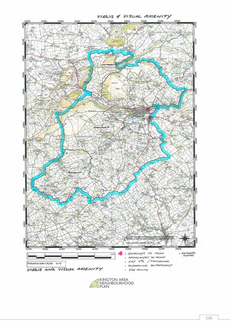
flora fauna and trees of the river banks bull the distant and near views of the landscape especially from Hergest Ridge
Bradnor Hill Kingswood and areas within Huntington bull the relatively high proportion of pasturegrazing land that provides habitats for
plants birds and insects that diminish when arable becomes dominant bull narrow lanes with high hedges and banks providing rich corridors of biodiversity bull the ability to access much of the countryside that is much appreciated
Policy KANP ENV1 - A Valued Natural Environment
Development proposals will be required to conserve and protect the valued tranquil natural environment of the KANP area by
(i) protecting and enhancing the River Arrow and the Back Brook from the impacts of development
(ii) respecting protecting and enhancing important open spaces views and the arearsquos landscape quality as identified in the Character Appraisal-Kington (February 2016) and the Kington Area Landscape Sensitivity and Capacity Assessment (October 2015)
(iii) respecting topography and not being visible against the skyline when seen from a distance whether the development be residential agricultural or industrial
(iv) conserving protecting and enhancing local habitats and areas of biodiversity value
(v) conserving and protecting woodlands and smaller stands of native trees (vi) conserving and protecting mature trees and hedgerows and incorporating
these features into landscaping schemes (vii) planting a high proportion of native treehedge species within any new (viii) development (ix) protecting and enhancing local orchards from development and (x) protecting existing geodiversity
KINGTON AREA NEIGHBOURHOOD PLAN 2019-2031
22
Policy KANP ENV 2 ndash Dark Skies
To reduce light pollution and to improve the views of our night-time skies planning proposals that include external lighting will be required to demonstrate the following
(i) the nature of the proposed lighting is appropriate for its use and location and has minimal impact
(ii) the proposed lighting does not materially alter light levels outside of the development which will adversely affect the use or enjoyment of nearby buildings or open spaces
(iii) the proposed lighting does not impact upon highway safety within the locality and
(iv) the proposed lighting does not have a significant impact on protected species or wildlife within the locality
Policy Justification
911 The Plan will seek to preserve and enhance the KANP arearsquos attractive and valued natural environment
912 The KANP area is made up of enclosed moors and commons ancient timbered farmlands ancient border farmlands wooded hills and farmlands high moors and commons hills with long distance views looking west towards Wales east and south towards other parts of Herefordshire and beyond The KANP will seek to protect and enhance this valued environment for its biodiversity interest and for future generations to enjoy
913 Of note there is (see Appendices 6 amp 7)
bull The River Arrow bull The Back Brook bull 5 SSSIrsquos bull 51 Special Wildlife Sites bull 20 ancient woodlands bull 3 Registered Parks amp Gardens and 10 Unregistered Parks amp Gardens
914 Kington Town has many landscape features Most notable of these are the River Arrow the Back Brook and the valley walls at the base of which is the town settlement The River Arrow and Back Brook provide bank-side habitats which deliver strong biodiversity linkages around and through the town
915 The River Arrow feeds into the River Lugg a Special Site of Scientific Interest (SSSI) which in turn contributes to the River Wye which is a Special Area of Conservation (SAC) and an (SSSI) A SAC is designated under the Habitats Directive and is identified as being of European importance and therefore must be protected
916 To ensure on-going protection and enhancement of the natural environment a Characterisation Assessment has been prepared in 2016 for Kington Town as part
KINGTON AREA NEIGHBOURHOOD PLAN 2019-2031
23
of the evidence to support the policies contained in the KANP This study has identified important open spaces views and landscape features which need to be protected from development they are listed and indicated in the report by OHA Architects Character Appraisal-Kington The Landscape Sensitivity and Capacity Assessment report by Carly Tinkler provided an appraisal of the rural areas including those surrounding Kington Town
KINGTON AREA NEIGHBOURHOOD PLAN 2019-2031
24
92 Built Environment
Consultation Feedback
bull Strong support for use of materials that are either lsquolocalrsquo eg stone lsquotraditionalrsquo eg timber framed rendered exteriors or of similar type to those found in older parts of the town in contrast there is dislike of non-mellow redbrick and lsquoaggressiversquo roofs This received support from the report commissioned from OHA (see Appendix)
bull A desire to maintain the lsquocharacter of the older building styles and materials so that the town is distinctive and does not become something that can be found anywhere in the country (Kington Local Action Plan Survey Report June 2013)
bull March 2014 public meeting on housing produced similar comments Additional comments that lsquogood quality lsquomodernrsquo design can be acceptable if architects design in sympathy with the existing environment
bull An appreciation and concern for the maintenance of the existing town centre and its historic structure and buildings Main part of the town is laid out on a medieval linear grid pattern with the High Street running eastwest and the housing plots developed from it running northsouth the plots and the old town boundary were marked by boundary walls the burgage walls uniquely made of stone which has been the local building material for centuries These are a special feature of Kington with the alleyslanes allowing pedestrian access to the High Street
bull The walls are suffering from neglect and in a number of places have been breached The better maintenance of the walls is strongly supported They are in the Conservation Area but there is a desire for them to have the further protection of listed status
bull The High Street used to be the main droving road along which stock was driven entries to dwellings was from the rear and not from the street sides some buildings retain the railings on their fronts to guard against damage from animals
bull The designated Conservation Area is considered to be too limited there is strong support for extending it to the east end of Victoria Road to include the historic foundry building and also at the north-west end beyond the parish church to the site of the castle mound (see Conservation Area Plan in Appendix)This latter area is considered to be where the original settlement was located near the Back Brook and the castle and the route westwards into Wales
KINGTON AREA NEIGHBOURHOOD PLAN 2019-2031
25
Policy KANP ENV3 - A Valued Built Environment
Development proposals will be required to conserve protect and where possible enhance the heritage assets and the wider historic environment of the Kington KANP area by
(i) demonstrating that the proposed development does not substantially harm designated heritage assets
(ii) where proposals lead to less than substantial harm to the heritage asset this should be weighed against the public benefits of permitting them
(iii) presenting a balanced judgement of the scale of harm to and significance of non-designated heritage assets
(iv) respecting and conserving both individual buildings and groups of buildings with functional connections
(v) respecting conserving and where possible enhancing the setting of nationally and locally historically significant buildings and registered heritage assets
(vi) taking every opportunity through design and materials to reinforce local distinctiveness and a strong sense of place incorporating local heritage features as set out in AppendiX 3
(vii) conserving and enhancing the significance of the Kington Town Conservation Area such that it can be removed from the national Heritage at Risk Register
(viii) conserving and respecting the historic Burgage walls of Kington Town and acknowledging them as non-designated heritage assets and
(ix) taking full account of known surface and sub-surface archaeology and ensuring unknown and potentially significant deposits are identified and appropriately considered during development after consultation with the Historic Environmental Record (HER) Lack of current evidence of sub-surface archaeology must not be taken as proof of absence
Policy Justification
921 There are numerous listed buildings within the KANP area and fourteen Scheduled Ancient Monuments (SAMs) Within Huntington there are several SAMs currently recorded in the Buildings at Risk Register (Turret Trump at Huntington Turret Castle Huntington Castle) Huntington Castle is also a grade 2 listed building at risk In the Rural Areas there are some notable listed farmhouses (see Appendix 1)
922 Kington Town has a Conservation Area which was designated in 1969 This designation seeks to protect the Townrsquos natural and historic assets The Conservation Arearsquos special architectural and historic significance is based upon its historic development with the Town dating back to the 12th century The medieval period is largely responsible for its oldest buildings but during the 18th
KINGTON AREA NEIGHBOURHOOD PLAN 2019-2031
26
century many earlier timber-framed structures were re-fronted encased or replaced by Classically-inspired Georgian facades
923 Today the essential character of the Conservation Area is that of a small historic market town with a tight urban grain The town centre buildings are predominantly three stories tall constructed using a mixture of coursed and natural stonework painted brickwork white render painted timber sash windows and doors and slate roofs with brick chimney stacks It is a concern that the Conservation Area is currently on the national Heritage at Risk Register
924 A particular feature of the Town is its town centre burgage boundary walls that also delineate pedestrian lanes which are an important element of the medieval town plan and help to establish the atmosphere and experience of Kington
925 To ensure on-going protection and enhancement of the built environment of the plan area the Character Appraisal-Kington (February 2016) has been prepared for Kington Town as part of the evidence to support the policies contained in the KANP This study has identified important key heritage features which should be protected and taken forward and included within future schemes A list of these heritage features is provided in the OHA report This will help ensure successful integration of new build within the built form of the area whilst protecting its special character
KINGTON AREA NEIGHBOURHOOD PLAN 2019-2031
27
93 Settlement Boundaries Kington Town and Hergest
Consultation Feedback
Kington Town
A settlement boundary for Kington Town was established in the Herefordshire Unitary Development Plan (2007) The AECOM Site Options and Assessment (2015) report which forms a background report to the KANP reviewed potential sites within and adjacent to Kington Town Much of the UDP boundary is retained but with amendments made on the east north and south of the town as follows
bull to the south extensions will now include the ldquoLand South of Kingtonrdquo and a green buffer space
bull to the north it will follow the parish boundary more closely bull to the east it will follow the parish boundary near the A411 and the building line to
the north and south of the River Arrow
This revised settlement boundary was discussed and agreed at the Town Council meeting on November 6th 2017 (See Plan 1)
Hergest
Following the decision to allocate the site adjacent to Arrow View for housing a settlement boundary was defined to include this site the existing housing estate Arrow View and the adjacent fields This was agreed by Kington Rural Parish Council on May 18th 2017 (see Plan 2)
KINGTON AREA NEIGHBOURHOOD PLAN 2019-2031
28
Policy KANP SB1 - Settlement Boundaries Kington Town and Hergest
Kington Town
In accordance with Policy KG1 of the Core Strategy and to meet the housing needs of all sections of the community the settlement of Kington will accommodate around 200 new homes during the plan period To deliver this growth a Settlement Boundary has been defined for Kington Town as shown in Plan 1 Development proposals will be directed to sites that fall within this boundary in accordance with other relevant policies of this Plan
Hergest
In accordance with Core Strategy Policy RA2 the settlement of Hergest will act as a focus for development to meet the needs of Kington Rural amp Lower Harpton Group Parish and to contribute to the target set for the Kington Housing Market Area To deliver this growth a Settlement Boundary has been defined for Hergest as shown in Plan 2 Development proposals will be directed to sites that fall within this boundary in accordance with other relevant policies of this Plan
Rural Areas
Outside the two defined settlement boundaries housing proposals will need to comply with Herefordshire Core Strategy policies Policy H2 - Rural Exception Sites Policy RA3 - Dwellings in Herefordshirersquos Countryside Policy RA4- Agricultural Forestry and Rural Enterprise Dwellings and Policy RA5 - Re-use of Redundant Rural Buildings
KINGTON AREA NEIGHBOURHOOD PLAN 2019-2031
29
Plan 1
KINGTON AREA NEIGHBOURHOOD PLAN 2019-2031
30
Plan 2
KINGTON AREA NEIGHBOURHOOD PLAN 2019-2031
31
Policy Justification
931 As one of the Countyrsquos five market towns Policy KG1 of the Core Strategy identifies the settlement of Kington as a focus for growth to accommodate around 200 new homes to meet local housing requirements deliver affordable housing and help support the services and facilities of the town centre
932 Policy RA2 of the Core Strategy identifies the settlement of Hergest as a focus for growth to meet the needs of Kington Rural and Lower Harpton Group Parish
933 Settlement Boundaries have been drawn to define the limits for development for Kington Town and Hergest Within these boundaries there is a general presumption in favour of development whilst land and buildings outside the boundaries are subject to a more restricted approach to development in order to safeguard and protect the valued countryside
934 The Parish of Huntington does not have an identified settlement so is regarded as open countryside with development limited to specific circumstances as detailed in Policies RA3 RA4 and RA5 of the Core Strategy
935 For Kington Town a previous settlement boundary was included in the adopted Herefordshire UDP This UDP boundary has been taken as the starting point for the KANP and reviewed using the following criteria
(i) Lines of communication ndash the boundary traces the edge of the built-up area and should exclude roads paths railways and other lines of communication
(ii) Physical features ndash the boundary follows physical features including buildings field boundaries and curtilages However in order to conserve the character and to limit expansion settlement boundaries can exclude large gardens orchards and other areas
(iii) Planning History ndash The boundary has been drawn to reflect planning decisions including existing commenced planning permissions and new developments
(iv) Town enhancements ndash Land and buildings have been included which contribute and make up the town form or offer the opportunity for improvements
(v) Important amenity areas ndash Important amenity areas which form part of the character of the settlement have been identified protected by policy and included in the settlement boundary due to their contribution to built form
(vi) Potential allocations
936 Taking on board the criteria above the proposed settlement boundary for Kington Town as identified in Plan 1 reflects the previous UDP boundary line the Parish Boundary and the main building lines with further amendments (see Consultation section above)
KINGTON AREA NEIGHBOURHOOD PLAN 2019-2031
32
937 The settlement of Hergest previously has not had a designated Settlement Boundary One has been drawn through the KANP process following the above criteria as shown on Plan 2
KINGTON AREA NEIGHBOURHOOD PLAN 2019-2031
33
94 Housing Delivery
Consultation Feedback
Comments made at a number of events
bull Future development in Kington Town to be delivered in small clustersinfill preferably on brownfield sites
bull A mix of homes ndash family homes amp bungalows bull Homes with flexible space to allow working from home bull New homes should have good sized gardens room sizes larger than minimum
national standards off- street parking space and play areas and easy access to the town centre
bull Design of estates important eg not serried rows but cul-de-sacscommunity groupings with plenty of green spaces not like cities
bull A large number of comments hellip any new build whether individual or in groups should be to high eco-standards where possible using renewable energy
bull Delivery of low maintenance and highly energy efficient housing of high quality design
bull Sustainable good quality truly affordable housing to meet local needs bull Retain existing green spaces bull Meet development needs bull Housing for the elderly (sheltered housingsmaller units for older people) in
accessible locations near facilities bull Employ a mix of styles and traditions using local materials bull Design to attract younger families to the area and redress ageing population bull Building sites should retain existing hedges with native species bull Land should be properly surveyed and drained before building is allowed to start
(Kington Park is a good example of where this did not happen)
941 Considerable attention was directed to meeting the objective repeatedly expressed by local residents during consultations that developments in Kington Town should be in small clusters and preferably on brownfield sites
942 About 50 of the housing target numbers has been met by allocating small sites However meeting the desire completely was difficult There is only one relatively small brownfield site within Kington Town and it is included in the allocations however given the densely built nature of the town and the significant constraints identified in the Core Strategy it was not possible to accommodate the remaining 50 in a similar way Thus one larger site is identified its landscape impact has been subjected to professional advice
943 In addition there is a clear desire and a requirement that KANP delivers some affordable housing which can be ensured only when a threshold of above ten dwellings is achieved A larger site offers the benefit of ensuring that a proportion of affordable housing will be in the mix of dwellings built in Kington
944 The Herefordshire Core Strategy requires all Neighbourhood Plans to identify allocate and manage the delivery of housing sites in the County The Regulations also require Neighbourhood Development Plans to be prepared in conformity with the strategic policies of the Core Strategy
KINGTON AREA NEIGHBOURHOOD PLAN 2019-2031
34
945 The KANP seeks to enable managed housing growth to meet the needs of the local community and deliver proportionate growth in line with the requirements of the Herefordshire Core Strategy whilst protecting as much as possible the environmental setting that the area enjoys To meet the housing requirements of the KANP area a thorough assessment of potential housing sites was undertaken as documented in the AECOM Site Options and Assessment 2015 report as well as an assessment of the surrounding landscape (Kington Area NDP Landscape Sensitivity amp Capacity Assessment) These two documents form evidence- based reports to the KANP In addition a Housing Audit Trail (Appendix 11) has been prepared as a background report to this KANP which explains the process behind the choice of housing sites now allocated in the KANP
KINGTON AREA NEIGHBOURHOOD PLAN 2019-2031
35
Kington Town Housing
Policy KANP H1 - Housing Delivery Kington Town
The KANP will provide for around 200 new homes to meet the housing needs of the market town of Kington over the plan period between 2011 and 2031
New housing proposals will be supported on sites that lie within the defined Settlement Boundary for Kington in accordance with other relevant policies of this Plan
The affordable housing needs of the Town will be provided in accordance with Policy H1 and H2 of the Core Strategy
New housing will be delivered through
bull dwellings which have been constructed or have planning consents granted since 2011
bull windfall opportunities delivered on appropriate infill sites within the settlement boundary
bull 6 sites allocated for residential development in Kington Town to provide a range and mix of houses
Where viable developments will be expected to contribute financially to all s106 CIL (Community Infrastructure Levy) and local infrastructure requirements
The following sites have been allocated in the KANP as shown on Plan 1
bull K1 (3) ndash Land to the Corner of Llewellin Road and Garden Close 4 dwellings and garages
bull K2 (5) ndash Site off Victoria Road10 dwellings bull K3 (8) ndash Old Wesleyan Chapel Crabtree Lane 10 dwellings bull K4 (9) ndash Field adjacent to Mill Street 15 dwellings bull K5 (12) and K6 (13) ndash Land South of Kington 100 dwellings
Figures in brackets are those used in earlier documents and in the attached assessment reports including the AECOM Site Options and Assessment 2015
Policy Justification
946 The Core Strategy Policy KG1 identifies Kington as one of the five Market Towns in the County to be a main focus for growth to deliver around 200 dwellings by 2031
947 Kington Towns strategic target of around 200 dwellings is based on analyses such as past progress with building rates local housing requirements infrastructure physical characteristics of the town and its capacity to accommodate further housing Core Strategy Policy KG1 directs the target to be delivered through a mix of both market and affordable homes with the affordable homes being delivered in accordance with Policy H1 of the Core Strategy Of these 200 dwellings as at April 2017 14 have already been built 28 have been committed leaving a residual
KINGTON AREA NEIGHBOURHOOD PLAN 2019-2031
36
housing requirement of around 158 dwellings to be provided in Kington Town during the remaining plan period to 2031The residual requirement of 160 dwellings is being met through the KANP housing allocations which will deliver 138 dwellings with the windfall opportunities delivering 26 dwellings based on an estimated windfall rate of 2 a year for the remainder of the Plan period as shown in Table 1 below
Table 1 Kington Town Housing Delivery
Core Strategy Target 2011-2031 ldquoaround 200 dwellingsrdquo
Completions at April 2017 14
Planning permissions at April 2017 28
Site allocations 138
Windfalls 26
Total by 2031 206
948 To meet the housing requirement for Kington Town a thorough assessment of sites was undertaken (see the AECOM Site Options and Assessment report 2015 which forms a background report to the KANP) As a result of this assessment the following 7 sites were identified to deliver around 140 dwellings to meet the requirement for Kington Town
Sites allocated for housing development Kington Town (earlier site numbers in brackets)
K1 (3) ndash Land at the corner of Llewellin Road and Garden Close (4 dwellings) 004ha
949 The site is flat and available and is well placed for existing amenities It would need to be sensitively developed in keeping with neighbouring properties and the nearby open space There is a large tree on site which will need to be either removed or safeguarded There is also a telephone pole in the centre of the site Garages located on the site are likely to require demolition but can be replaced within any new development (eg) flats or maisonettes) Stonewater Housing Association own the site and it is understood that they are willing to sell it
K2 (5) ndash Site off Victoria Road (10 dwellings) 02ha 9410 This site lies off Victoria Road and is made up of existing buildings and hard
standing The site is surrounded by residential properties to the south
9411 Full planning permission was granted in 2010 for 10 residential units (N102016F) which included conversion of one of the existing workshops into 3 dwellings with the remaining 7 dwellings being new builds Of these new builds the 3 terraced houses were to be affordable This permission has expired
9412 The site is available and well placed in terms of existing amenities It will need to be sensitively developed to ensure that it is in keeping with neighbouring properties There are no significant constraints identified at this stage although it is located close to Flood Zone 2 The site is available
KINGTON AREA NEIGHBOURHOOD PLAN 2019-2031
37
9413 The site is located on an area of land which was historically used as a Gas Works (a potentially contaminative use) consideration will need to be given to this prior to any development K3 (8) ndash Old Wesleyan Chapel Crabtree Lane (10 dwellings) 017ha
9414 The site is well placed for existing amenities It is a brownfield site in the existing built up area of Kington The site is in a Conservation Area so will need to be sensitively developed The site contains a Listed Building (the Chapel) which would need to be sensitively managed as part of any development on the site Planning permission for 4 dwellings on the site has expired (N102548F) The site is considered to have the capacity to deliver 10 dwellings including 4 new houses in the curtilage with the Chapel being converted into flats
9415 Delivering a sensitive scheme on this site whilst seeking to retain a Listed Building has inhibited development up to present Proposals for listed building consent to demolish will therefore be considered sympathetically if this is linked to a detailed master plan that maintains the iconic status of the site and reflects the massing of the existing building and the re-use of the stone
K4 (9) ndash Field adjacent to Mill Street (15 dwellings) 033ha
9416 The site forms open land adjacent to Mill Street The site is surrounded by residential properties to the north with open space to the south The site is well placed for existing amenities in Kington A new access road will be required to serve the development which should be taken from Markwick Close it should be designed to the satisfaction of the County Highway Authority The site also contains overhead telephone lines Development will be restricted to the northern end of the field This site is being identified to deliver sheltered one-storey housing accommodation to meet local housing needs for older andor disabled people
9417 A review of Ordnance Survey historical plans indicate the proposed site is adjacent to a former Textile manufacturing site It is possible that unforeseen contamination may be present consideration should be given to the possibility of encountering contamination and specialist advice sought should any be encountered during the development
K5 (12) ndash Land east of Kingswood Road 21 ha and
K6 (13) ndash Land east of Kingswood Road 273 ha (100 dwellings in total)
Jointly described as ldquoLand South of Kingtonrdquo
9418 Sites K5 and K6 are agricultural land (Grade 23) located close to and east of Kingswood Road In accordance with paragraph 112 of NPPF it was found necessary to allocate this land for housing development because of the total lack of suitable sites on poorer quality agricultural land The sites are bounded to the south and west by open farmland Both sites were identified by the landowners as potential housing sites to help meet the housing allocation in the KANP Although development of the site will entail a significant extension to Kington it can be designed with an effective landscaping scheme that will mitigate its impact on the surrounding area The two adjacent sites together form an allocation called lsquoLand South of Kingtonrsquo
9419 Sites K5 and K6 jointly form a residential extension to Kington ndash Land South of Kington The overall capacity of these adjacent sites combined is around 100
KINGTON AREA NEIGHBOURHOOD PLAN 2019-2031
38
dwellings A new access road will be required Vehicular access off Kingswood Road will not be possible because of its narrow width and a junction with Headbrook with very poor visibility A new access is proposed to the north of the amenity space of Kington Park with an access onto the Old Eardisley Road
KINGTON AREA NEIGHBOURHOOD PLAN 2019-2031
39
Strategic Residential Allocation Land South of Kington
Policy KANP H2- Housing Delivery Land South of Kington
A comprehensive development proposal on Land South of Kington which delivers a sustainable extension to Kington Town will be supported subject to meeting the following requirements
(i) Development of around 100 new homes at an average of approximately 20 dwellings per hectare comprising a mix of market and affordable house sizes and types that meet the requirements of Policy H3 of the Core Strategy and the needs identified in the latest version of the Herefordshire Local Housing Market Assessment 35of the total number of dwellings must be affordable housing to meet the requirements of Policy H1 of the Core Strategy and to be retained in perpetuity
(ii) a proportion of dwellings to meet life-time homes standards and the needs of the age profile of the local population
(iii) provision of vehicular access arrangements which meets the requirements of the Herefordshire Highways Design Guidance If access is designed from Old Eardisley Road and adjacent to the north end of Kington Park Amenity land the access road should be edged with a substantial fence and hedgerow on its south side
(iv) a development that is led by a landscape strategy to minimise impact on the environmental setting of Kington
(v) retention and enhancement of existing hedgerows and trees and the widening of hedgerows and some tree planting to the west east and south of the site
(vi) development of bespoke high-quality and inclusive design that contributes to the distinctiveness of this part of Kington
(vii) new green infrastructure together with walking and cycling links from the development to the town centre as illustrated in Diagram 1
(viii) footpath connections to allow pedestrian access onto Kingswood Road
(ix) sustainable standards of design and construction (x) a comprehensive sustainable drainage system which includes
measures to manage ground and surface water drainage and safeguard against increased flood risk and complies with SD3 of the Core Strategy
(xi) connection to the mains water infrastructure network to comply with SD4 of the Core Strategy
(xii) maximum use of permeable surfaces (xiii) provision of open access amenityplayground space and (xiv) minimal use of external artificial lighting
The scheme will be expected to engage and consult with the community where viable to meet all s106 and CIL requirements
KINGTON AREA NEIGHBOURHOOD PLAN 2019-2031
40
Diagram 1 Indicative Masterplan for Land South of Kington (sites K5 and K6)
KINGTON AREA NEIGHBOURHOOD PLAN 2019-2031
41
Policy Justification
9420 Land South of Kington forms a 48 ha greenfield site and is allocated for residential development following a comprehensive assessment of potential housing land both within and adjacent to Kington Town The site is located on the southern fringe of the urban area of Kington approximately a 10-minute walk from the High Street
9421 An assessment of this potential housing land Sites Option and Assessment Study was undertaken by AECOM in 2015 the Study forms a background report to this KANP The assessment was informed by studies of local landscape characteristics Kington Area NDP Landscape Sensitivity amp Capacity Assessment and a full analysis of views and visual amenity with a strong emphasis on local distinctiveness and sense of place thus meeting design and landscape policies in the Core Strategy especially policies SS6 KG1 LD1 ndash LD4
9422 Land South of Kington is assessed as being relatively well-contained and capable of accommodating sensitively designed development The aspect topography and position of the site relative to the surrounding countryside means that development can be assimilated into the landscape forming part of the wider vista where open landscape is still the dominant component in the view albeit with the urban area of Kington in the foreground
9423 The site nestles in the north facing slopes of the higher ground located to the south of Kington The land is largely pasture with mature hedges and scrub vegetation demarcating the edges of the site These mature hedges are a key characteristic of the site and it is envisaged that they should be retained and strengthened A pond habitat is located in close proximity to the northern boundary but beyond the site There are a number of open fields to the west of the site beyond Kingswood Road and to the south where large pockets of mature trees and woodland lie To the east more recent developer-led residential development is accessed off Old Eardisley Road
9424 A development will need to be designed to knit with the existing urban area and with a housing layout responsive to the topography of the site whilst respecting the wider landscape setting great attention should be paid to the landscaping of southern and western boundaries of the site because of the potential impact on the wider landscape This landscape sensitivity is highlighted by the site boundary to the south and west also being the proposed Settlement Boundary for Kington
9425 The land while steep is relatively even in its fall from south to north and it is clear that while the topography could be modified to accommodate development there is also the opportunity to use that same topography to create an interesting townscape with a roofscape that helps to characterise and add interest to the site both in long and shorter distance views
9426 Green infrastructure including landscaped amenity open space and childrenrsquos play areas should be provided within the development to meet the needs of future residents and to compensate for any amenity land greenspace lost to provide access to the site from Eardisley Road
9427 Housing proposals on Land South of Kington will be required to deliver high quality sustainably constructed new homes to meet housing need and demand especially for that of smaller open market housing and affordable housing
KINGTON AREA NEIGHBOURHOOD PLAN 2019-2031
42
9428 One of the distinctive features of Kington Town is the diversity of building sizes and heights some in clusters or groups with intervening spaces Development on this area of land that can accommodate about 100 dwellings should aim to reflect the diversity found within the existing Town and not be planned as a distinct separate housing estate
9429 Additional pedestrian access to the site is achieved via Headbrook and then Kingswood Road There will be no vehicular access on Kingswood Road but a new access point will be taken from Old Eardisley Road to the east of the site However in order to deliver this new access it might be necessary to upgrade the junction of Headbrook and Old Eardisley Roads Applications will need to be supported by a Transport Assessment and should have regard for the requirements set out in the Herefordshire Councilrsquos lsquoHighways Design Guide for New Developmentsrsquo (2006) and Manual for Streets
9430 Any development proposals for the site should seek to maintain existing pedestrian routes and enhance the existing connectivity for walkers and cyclists and where possible extend the network especially to the east of the site It is envisaged that the existing pedestrian routes to the west would continue to provide a quick and easy access to the town centre and these could be extended to accommodate cyclists also with existing access points from the site retained and new ones introduced where possible
9431 A bus stop is located on Headbrook Road to the north This stop is within walking distance and links the site with the town centre and surrounding towns via routes 461 462 and 463
9432 The site is outside the areas of River Arrow flood risk
9433 Welsh Water have provided the following information with respect to water supply and foulsurface drainage matters related to the site Water supply Given the size of the proposed development site and the small diameter distribution water main in the adjacent Kingswood Road a hydraulic modelling assessment (HMA) of the water supply network may be required in order to understand where a connection can be made and if any upsizing is required Potential developers can commission Welsh Water to undertake a HMA and fund any improvements via the Requisition provisions of the Water Industry Act 1991
Public sewerage There do not appear to be any issues in the proposed development site connecting into our combined public sewer in the adjacent Kingswood Road
Wastewater treatment works (WwTW) Kingtonrsquos WwTW is currently overloaded and there are no improvements planned within Welsh Waterrsquos current Capital Investment Programme (AMP6 ndash 1st April 2015-31st March 2020) An improvement scheme will form part of their submission to the Industry Regulators for the next Capital Investment Programme (AMP7 ndash 1st April 2020-31st March 2025) As such should a developer wish to progress this site in advance of their future Regulatory Investment they will need to fund the improvements themselves firstly by commissioning Welsh Water to undertake a feasibility study of the WwTW before entering into a Section 106 Agreement (of the Town amp Country Planning Act 1990) to pay for the improvements required
KINGTON AREA NEIGHBOURHOOD PLAN 2019-2031
43
9434 In view of the significance of the development to the local community pre-application consultation on the proposed development with the community and the Town and Parish Councils will be welcomed
KINGTON AREA NEIGHBOURHOOD PLAN 2019-2031
44
Kington Rural and Lower Harpton Group Parish Housing
Policy KANP H3 - Housing Delivery Kington Rural and Lower Harpton Group Parish Development proposals will be supported that provide a minimum of 32 new homes to meet the housing needs of the Kington Rural and Lower Harpton Group Parish and will contribute to the wider housing market area over the plan period between 2011 and 2031
New housing will be delivered through
bull dwellings which have been constructed or have planning consent bull windfall opportunities delivered on appropriate infill sites within the settlement boundary of Hergest bull windfall developments on sites outside the settlement boundary of Hergest which meet Policy RA3 RA4 and RA5 of the Core Strategy
In addition and in accordance with Policy RA2 of the Core Strategy Land North of Arrow View Hergest (KR1) as shown on Plan 2 is allocated for a residential development of approximately 15 houses This scheme will be expected to
(i) A full ecological and tree survey shall be undertaken and submitted as part of any Planning application taking account of the advice of the Countyrsquos Ecologist The Proposals for the development of the site shall include proposals to enhance the local habitat and the provision of open space
(ii) provide a range and mix of houses to meet local housing requirements including affordable homes in accordance with Policy H1 of the Core Strategy
(iii) meet sustainable standards of design and construction (iv) provide an amenity playground space (v) include minimal use of external lighting (vi) deliver a comprehensive sustainable drainage system to comply with
SD3 of the Core Strategy (vii) deliver connection to the mains water infrastructure to comply with
SD4 of the Core Strategy (viii) retain and enhance the southern boundary hedgerow (ix) deliver a pedestrian and cycle shared path on the inside of the
southern boundary hedgerow and (x) deliver satisfactory vehicular access in conformity with Herefordshire
Highways Design Guidance
The affordable housing needs of the Group Parish will be provided in accordance with Policy H1 and H2 of the Core Strategy
Proposals will need to comply with Policy KANP H5 Housing Design Criteria
Subject to viability considerations developments will be expected to contribute financially to all required s106 and CIL requirements Financial contributions to highway improvements for a safe shared pedestrian and cycle route between Hergest and Kington will be strongly supported to enhance road safety All financial contributions sought will need to be CIL compliant KINGTON AREA NEIGHBOURHOOD PLAN 2019-2031
45
Policy Justification
9435 The Core Strategy Policy RA1 identifies a need to deliver 5300 new dwellings in the rural areas of the County during 2011-2031 with an emphasis on affordable dwellings New dwellings are to be broadly distributed across the County based on HMAs each of which has a growth target that is applicable to villages within the respective HMA
9436 The Core Strategy in Policy RA1 specifies that Kington Rural HMA has a proportional growth target of 317 dwellings to be delivered during the plan period The figure of 317 was established by assessing all the rural villages in the Kington Rural HMA This target represents an increase of 12 upon the existing number of properties within Kington Rural amp Lower Harpton Group Parish The proportional growth target provides the basis for the minimum level of new housing that will be accommodated in each Neighbourhood Plan
9437 The Core Strategy Policy RA2 identifies the settlement of Hergest as a sustainable settlement suitable for proportionate housing growth meeting the needs of Kington Rural amp Lower Harpton Group Parish
9438 It is expected that new housing proposals directed to settlements like Hergest should reflect the size role and function of the settlement and should be located within or adjacent to the main body of the settlement The Policy states that proposals will be expected to demonstrate particular attention to the form layout character and setting of the site and its location in that settlement andor they result in development that contributes to or is essential to the social well-being of the settlement concerned It is also required that proposals must result in the delivery of schemes that generate the size type tenure and range of housing that is required in particular settlement reflecting local demand
9439 The 12 increase for Kington Rural and Lower Harpton Group Parish generates a minimum housing requirement of 32 dwellings to be provided between 2011 and 2031 Of these 2 dwellings have already been built 5 dwellings have been committed leaving a residual minimum requirement of 25 dwellings to be provided within the Parish during the remining plan period to 2031 The residual requirement of 25 dwellings is being met through a housing allocation at Hergest which will deliver 15 dwellings with windfall opportunities delivering 13 dwellings based on an estimated windfall rate of 1 a year for the remainder of the Plan period as shown in Table 2 below
KINGTON AREA NEIGHBOURHOOD PLAN 2019-2031
46
Table 2 Kington and Lower Harpton Group Rural Parish Housing Delivery
Core Strategy Target 2011-2031 32
Completions at April 2017 2
Planning permissions at April 2017 5
Site allocation 15
Windfalls 13
Total by 2031 35
9440 In terms of understanding local housing needs the Herefordshire Councilrsquos Rural Housing Background Report (March 2013) an evidence-based document informed the Core Strategy This report states that the Kington Rural HMA has a requirement for mainly three bedroomed market housing with a notable requirement for four-bedroom properties relative to other rural HMAs In the affordable sector smaller one and two-bedroom properties as well as three-bedroom properties are required although this will vary according to local needs evidence
9441 In addition in 2012 Herefordshire Council undertook a Housing Need Study for the Kington Rural and Lower Harpton Group Parish All 284 households within the Group Parish were sent a questionnaire 14 questionnaires were returned and of these 7 households were identified as needing an affordable home in the next three years
9442 Taking this information as a whole there is a need for both market and affordable housing within the Group Parish as well as a need for a range of smaller and some larger properties
9443 In terms of meeting this need the AECOM Site Options and Assessment report 2015 which forms a background report to the KANP assessed the potential of three sites at Hergest and concluded that site KR1 Land north of Arrow View Hergest as appropriate for allocation in the KANP for 15 dwellings
9444 This 12 ha brownfield site is located adjacent to an existing residential development 3km south west of Kington town centre The River Arrow is directly to the north of the site and at a lower level
9445 The site is located on an area of land which was used as military land in WWII and lies adjacent to the bases of former petrol tanks (potentially contaminative use) which will require consideration prior to any development
9446 A tall hedgerow and mature trees screen the site from Hergest Road Arrow Court Industrial Estate is located east of the site There are turkey farming sheds located further south of the existing Arrow View development isolated houses are situated south and west of the existing Arrow View development
9447 The design and layout of any future proposal will need to be consistent with adjacent development In addition its development will need to address (in discussion with the Local Planning Authority) the current status of the priority habitat Deciduous Woodland and the proximity of the nearby turkey farm sheds
KINGTON AREA NEIGHBOURHOOD PLAN 2019-2031
47
9448 A full ecological and tree survey should be required including some longer-term survey work during optimal times of the year for bats birds others amphibians and reptiles Any development should demonstrate full mitigation and a high level of enhancements including but not limited to bird and bat roosting opportunities inon the new buildings hedgehog and pollinator homes and reptileamphibia refuges in the retained habitat areas and a long term management strategy for the remaining trees riverside and flood meadowgrass areas
9449 The relatively low density will allow some plots to have sufficient land for small home-based enterprises and the provision of community allotments
9450 A development proposal on the site must deliver a landscape and ecology led development which includes a comprehensive sustainable drainage strategy for surface water management creating an exemplar green and ecological development utilising ecosystems management
KINGTON AREA NEIGHBOURHOOD PLAN 2019-2031
48
Huntington Parish Housing
Policy KANP H4 - Housing Delivery Huntington Parish
In the rural parish of Huntington new homes will be supported only where they comply with Herefordshire Core Strategy policies on rural exception sites (Policy H2) dwellings in Herefordshirersquos countryside (Policy RA3) agricultural forestry and rural enterprise dwellings (Policy RA4) and the re-use of rural buildings (Policy RA5)
Proposals will need to comply with Policy KANP H5 Housing Design Criteria
Policy Justification
9451 The rural Parish of Huntington lies in countryside and in line with national and local plan policies proposals for residential development in the open countryside will be supported only where they will provide
a homes that meet an agricultural or forestry need or other farm diversification enterprise for a worker to live permanently at or near their place of work or are necessary to allow a rural enterprise to be retained or grow such homes also need to comply with policy RA4 of the Core Strategy
b replacement of existing dwellings c re-use of redundant or disused buildings where there is compliance with
Policy RA5 d rural exception sites ndash small affordable housing schemes that meet proven
local needs where there is compliance with Policy H2 e the design is innovative and of exceptional quality and meets the criteria set
out in Paragraph 55 of the NPPF
9452 The rural Parishes in the KANP have an ageing population and the consultations evidenced the desire that the KANP should encourage young people to live and work in the community As a result the KANP will strongly support proposals to re-use redundant or disused buildings to meet this need
9453 The survey for Huntington Parish concluded that at the time of the survey there was no affordable housing need identified
KINGTON AREA NEIGHBOURHOOD PLAN 2019-2031
49
Housing Design Criteria
Policy KANP H5 - Housing Design Criteria
All housing proposals will need to
(i) Be of a high-quality design in keeping with the immediate surroundings respect and where possible enhance the natural built and historic environment of the Neighbourhood Plan Area including the Kington Conservation Area
(ii) take every opportunity to incorporate local heritage features materials and traditions to reinforce local distinctiveness and provide a strong sense of place Stone timber cladding or rendered walls and slate roofs will be preferred to large areas of dark or bright red brick For Kington Town local heritage features have been defined and are provided at Appendix 3 of this Plan
(iii) be of a scale form and layout which meets local housing need complements the character of the area and protects residential amenity
(iv) include energy efficient measures renewable energy generation and deliver sustainable design including water conservation measures
(v) include safe access sufficient vehicle parking provision for users and cycle storage in conformity with Herefordshire Highways Design Guidance
(vi) supply all dwellings with rain-water butts and space for recycling and waste bins
(vii) provide multi-functional green infrastructure and community amenity space proportionate to the number of dwellings Contributions to new or improved off-site provision nearby may be acceptable only for small housing developments where it is not feasible to provide open space on site
(viii) be located on sites that lie outside the flood zone 2 and 3 areas as defined by the Environment Agency
(ix) development proposals will be required to accord with Policy SD3 and SD4 of the core strategy and
(x) be developed within the capacity of the local infrastructure
Policy Justification
9454 Policy KANP H5 identifies housing design criteria which addresses issues raised by the community through consultation These criteria need to be fully addressed and used to inform future residential proposals In addition and as part of this KANP a Character Appraisal - Kington (February 2016) was undertaken for Kington Town which identified key designheritage features and local materials all of which need to be incorporated into future proposals for the area This will ensure that future developments are locally distinctive and preserve as well as contribute positively to its environs including that of the Kington Conservation Area
KINGTON AREA NEIGHBOURHOOD PLAN 2019-2031
50
95 Employment
Consultation Feedback
Shortage of local job opportunities for young people Suitable affordable premises are not easy to find for lsquostart-uprsquo enterprises Rate relief offered in Powys (Presteigne) attracts people to establish business
in Wales More locally produced food should be in the local shops Obtaining planning permission for business premises is expensive Large houses should be built for people who will provide employment in new
businesses If large numbers of houses are built Kington will become a commuter town unless new employment possibilities are developed
Need to advertise and promote the two industrial estates which are currently under-used
The area has a lot of construction skills in the population they should be co-ordinated to provide a local construction co-operative
KINGTON AREA NEIGHBOURHOOD PLAN 2019-2031
51
Policy KANP E1 - A Thriving Rural Economy
Proposals which make better use of land at Hatton Gardens Industrial Estate and Arrow Court Industrial Estate for employment purposes will be encouraged
Proposals which deliver small-scale affordable employment opportunities farm diversification opportunities as well as live-work units and home-based employment will be supported through
bull small- scale new build or workshops on sites within the defined Settlement Boundaries of Kington Town and Hergest
bull the conversion and reuse of redundant rural buildings to business use to include live-work units
bull use where possible of previously developed landbuilding opportunities
bull small-scale extensions to existing employment operations bull small scale extensions to existing residential properties to enable
home working bull development and diversification of existing agricultural businesses
and other land based rural businesses
All proposals will need to ensure that they
(i) protect the character and tranquility of the KANP area (ii) can be safely accessed and accommodated on the local highway
network (iii)are of a scale and massing that is commensurate with their
surroundings (iv)protect residential amenity (v) protect and where possible enhance landscape quality biodiversity
local water-courses and the historic environment (vi)can be undertaken within the capacity of the local infrastructure and
(vii) can address drainage and flooding issues
Any development shall not impact on local amenity or have any adverse impacts on the River Arrow Back Brook and River Lugg SSSI
All proposals must comply with Policies RA5 RA6 and Policies E1 E2 E3 and SD1 SD3 and SD4 of the Herefordshire Core Strategy
KINGTON AREA NEIGHBOURHOOD PLAN 2019-2031
52
Policy KANP E2 - Large Scale Employment Activities
Proposals for large scale (exceeding 1000 sq m) employment activities including new agricultural developments such as intensive livestock units and extensive areas of polytunnels and the conversion of existing livestock enterprises to intensive husbandry techniques will only be supported where they provide detailed evidence to demonstrate that any adverse impacts can be adequately mitigated
Large scale employment proposals will need to ensure that they
(i) have taken into account the sensitivity and capacity of the landscape
(ii) are fully compliant with Policies KANP ENV1 ENV2 and ENV3 and will not have harmful impacts on the historic built environment local heritage assets and the amenity of local residents
(iii) can safely accommodate the type of traffic generated from such developments into the highway network by providing adequate access and addressing highway capacity safety and congestion matters
(iv) will not have adverse impacts on the biodiversity and ecology of the area
(v) will not have adverse impacts on the residential amenity of neighbouring properties arising from emissions affecting air water light and ambient noise levels
(vi) fully address drainage and flooding issues and are fully compliant with Policies SD3 and SD4 of the Herefordshire Core Strategy and
(vii) fully address the cumulative impacts of the proposed development
Policy Justification
951 The KANP seeks to promote sustainable economic growth which reflects and complements the local environment and encourages the younger generation to remain in the area
952 The KANP supports the growth of small- scale businesses which are commensurate with their surroundings and seeks to retain existing employment areas Grant assistance to support diversification and business growth can be found at the Marches Growth Hub
953 The KANP encourages businesses started by people looking initially or permanently to work from home as well as proposals related to farm diversification in order to maintain a successful farming community In addition the KANP supports the use of under-utilised buildings to provide incubation space to support start-up businesses
954 The Employment Land Study prepared by Drivers Jonas Deloitte in 2012 as part of the evidence base to inform the Core Strategy states that the size and type of premises in demand for areas like Kington is generally small (up to 140sqm)
KINGTON AREA NEIGHBOURHOOD PLAN 2019-2031
53
955 The KANP will safeguard existing employment areas including Hatton Gardens Industrial Estate and Arrow Court Industrial Estate for employment uses for B1 and B8 uses In addition the KANP will support proposals which look to make better use of this land for employment purposes
956 Hatton Gardens Estate until the 1960s was fully occupied by a railway station and goods yards and an area where cattle and sheep were held pending being transported elsewhere During 1943-45 war casualties were brought by train before being taken by road ambulances to the large American Army Hospital at Hergest Camp now the Arrow Court Industrial Estate
957 There are now a number of different businesses in leasehold premises On the southern edge there are domestic dwellings and a Veterinary Practice There is a slow turn-over of occupants and some areas of the estate that could be more intensively used There are constraints as the estate lies between the Back Brook and the Arrow and is on the edge of the floodplain
958 An area on the western edge abutting the A44 junction has recently been cleared Proposals to relocate the Fire Station and other Emergency Services to this easily accessible vacant area will be strongly supported Such re-location would free up land that is in a residential area for housing
959 Arrow Court Industrial Estate at Lower Hergest is on the site of a large WW11 Army camp The units on the site now house a variety of small-scale enterprises some of them start-ups There are generally vacant units and capacity for further expansion if required The land is flat and adequately provided with mains services
9510 Proposals for the construction of further units that could provide local employment will be strongly supported as will proposals to construct higher quality premises Road access is by a C class road and from Kington to the east over a narrow bridge so any enterprise that would require servicing by large numbers of HGVs will not be supported
9511 Proposals to use part of the currently vacant land with a solar array or other suitable alternative technologies will be strongly supported
9512 The 2012 Employment Land Study reviewed the Hatton Gardens Industrial Estate It concluded that overall the site was classified as lsquoGoodrsquo in terms of its role within the overall hierarchy of employment sites within the County and that the quality of buildings on the site as generally good however in some areas roadparking would benefit from improvement The study also referred to the need for better footpath connections between the site and the rest of the Town
9513 The review of Arrow Court Industrial Estate concluded that there were low levels of occupancy the buildings and external areas of the site were of poor to moderate quality and condition with restricted provision of parking circulation and servicing Since 2012 new tenants have been attracted and new units have been constructed and conditions improved The site has further potential to provide a good quality environment for all types of industry
9514 The Study stated that there was potential for development redevelopment of poorer parts of the site which would contribute towards local regeneration for the
KINGTON AREA NEIGHBOURHOOD PLAN 2019-2031
54
area As part of this the width of surrounding roads would need to be addressed as at present they could create potential issues for HGV access
9515 The need to improve footpath and cycle connectivity within Kington Town and between Hergest and Kington Town is sought for inclusion within the Countyrsquos Local Transport Plan Further details are provided within Policy KANP INF 1
9516 A relatively high proportion of working age people in the area are self-employed or in small businesses Some of these are in agriculture or agricultural -related jobs Proposals for farm diversification and premises suitable for start-up businesses or home-working will be supported where they are likely to contribute positively to the local economy while having no adverse impact on the community or local environment
9517 Proposals that include large-scale buildings and their associated infrastructure will need to take into account the significance of the report Kington Area Landscape Sensitivity and Capacity Assessment (October 2015) a background evidence report to the KANP in which the sensitivity and capacity of the landscape are described
KINGTON AREA NEIGHBOURHOOD PLAN 2019-2031
55
96 Kington Town Centre
Consultation Feedback
Enhancement to the overall environment of Kingtonrsquos High Street sought
92 of respondents backed some kind of intervention to improve the situation for pedestrians eg ldquoThe experience of shopping in the town centre should be a pleasure not a hazardrdquo
Need wider pavements current ones too narrow for buggies and wheelchairs so people have to be in the road Parked vehicles obscure the sightlines making crossing dangerous People get hit by wing mirrors
40 favoured one-way traffic less support for shared surfaces or for total or partial pedestrianisation Little support for traffic lights at key junctions
Questionnaires in Huntington and in Kington Rural and Lower Harpton showed that Kington is the principal shopping destination for most people Adequate car parking is essential
bull Important to retain the character of the High Street bull In general a good range of goods and facilities available and used by people
coming into town to shop from nearby and much further away good car parking important to support the shops
bull Most shops ownedoperated by sole traders and therefore need more local support than do multi-nationals
bull Often difficult for young people to consider starting up or taking on a High Street shop as business rates can be high
bull Some types of enterprise find it hard to operatetrade where no parking is allowed in front of premises
bull High Street is a social as well as a commercial place bull No support for reducing the retail centre new owners come and go and at present
High Street maintains viable level of trade bull More regular markets should be encouraged bull Shops open at weekends would help bull Promote Kington Town independent shops as a positive feature of the Town bull Recent closure of the last high-street bank is deplored with concerns about the
impact
KINGTON AREA NEIGHBOURHOOD PLAN 2019-2031
56
Policy KANP KTC 1 - Kington Town Centre
Within Kington Town Centre development for retail leisure office commercial cultural and tourism uses will be encouraged Development proposals should be in accordance with Policies E5 and E6 of the Herefordshire Core Strategy
Development proposals will be assessed against the following criteria
(i) proposed retail developments should where possible be located in the Primary Shopping Frontages as defined on the Kington Town Centre Policies Map
(ii) developments should not adversely affect the primary function of the town centre of Kington as a shopping destination and be of a scale and design appropriate to the size role character and heritage of the centre
(iii) where new shop frontages are proposed they should be in keeping with traditional shop frontages in the Town
(iv) the re-use of upper floors for residential or office use will be encouraged (v) distinctive and detailed features of buildings should be retained and
enhanced (vi) new developments in the town centre should retain the original boundaries
of the burgage plots (vii) business premises should incorporate signage which minimizes use of
illuminated signs and lighting and ensure that it makes a positive contribution to the street scene and
(viii) every opportunity will be taken to seek an enhancement to the overall environment of the Kington High Street to
a reduce congestion and improve safety for all users b widen walking surfaces sufficient for all users c provide safer pedestrian crossing points linked to lanesbehind the High
Street and to the Primary School d improve street appearance and amenity e retain a route for buses and emergency vehicles in both directions f improve vehicular visibility at junctions each end of the High Street g provide clear definition of street surfaces for specific users h provide for safer collectionsdeliveries along the High Street i reduce traffic speeds and reinforce with traffic calming measures
Policy Justification
961 Within the Core Strategy Kington is classified as a Market Town that acts as an important service centre for its rural hinterland
962 The Core Strategy at paragraph 447 states that the expenditure forecast for Kington over the Plan period is unlikely to be of a scale to require proposals for further convenience floor space since many of the existing smaller units within the Town could absorb more turnover within existing floorspace
963 As part of the evidence base for the Core Strategy a Town Centres Study Update was prepared by Drivers Jonas Deloitte in 2012 The conclusions were
KINGTON AREA NEIGHBOURHOOD PLAN 2019-2031
57
bull the general health of Kington had declined slightly since the previous Study with a rise in the vacancy level in the centre and an increase in charity shops
bull the range of goods on offer in the town remained somewhat limited bull new retail convenience development within the centre should be encouraged
however is unlikely to be of a scale to warrant a development plan allocation bull new retail floorspace will be driven primarily by market considerations The role
of independent traders will be important but the current unfavourable economic climate is likely to inhibit investment in the initial part of the plan-period
bull definition of primary or secondary shopping frontages for Kington unnecessary a defined Primary Shopping Area (PSA) could suffice
bull a Primary Shopping Area for Kington could seek to tighten the current Town Centre boundary which extends north up Church Street to The Square This part of the centre had already seen a proliferation of residential conversions and no longer functioned as part of the retail area There was further scope to tighten the boundary along Mill Street and Duke Street
bull there was a large number of small units in the centre which could absorb more turnover on existing floorspace
bull any new development would need to be of a different type in terms for example of unit size so bringing a new form of retailing to the town
964 A recent survey was conducted by a member of the KANP steering group in January 2017 that covered all premises in the Town Centre including the High Street southern part of Church Street and northern part of Bridge Street 9 units were identified as vacant with 3 of them being refitted There were three charity shops
965 Compared with the Drivers Jonas Deloitte report in 2012 the number of vacancies is similar but with fewer charity shops It was noted that some of the units that had been vacant in 2012 are now occupied including in Church Street
966 There are several new enterprises in the town in addition there is a weekly market of food arts and crafts as well as a craft and local food market twice a month on a Saturday There is also the Kington Stock Market which is located within the town and holds weekly sheep sales and monthly store cattle sales These sales attract high numbers
967 On the first Saturday in December the Chamber of Trade organises a very successful Christmas Food Fair in the Town Centre In 2017 there were 90 specialist food and drink and some craft stalls it attracted a large number of visitors and local people A similarly successful Summer Food Fair is held in June
968 During 201617 both Barclays and HSBC Banks closed leaving the neighbourhood without high street banking facilities the Post Office is a useful substitute for some people but there is widespread concern at the impact of the closures
969 Almost all buildings in the Town Centre have residential (flats) on the upper floors and appear to have high occupancy rates and a quick turnover
9610 The KANP reviewed the UDP Central Shopping and Commercial Area Boundary and has decided to retain the current boundary as identifying the Primary Shopping Area for Kington given the level of housing growth anticipated for the town and its rural hinterland The Primary Shopping Area will remain the main focus for retail activity in order to ensure it is vital and vibrant for future generations to enjoy
KINGTON AREA NEIGHBOURHOOD PLAN 2019-2031
58
9611 Proposals will be encouraged which extend the variety choice and quality of shops and services and improve the overall attractiveness of the Town Centre
9612 Proposals which seek to reduce conflict between vehicles and pedestrians enhance the vitality viability overall environment and footfall of the High Street will be encouraged Funding opportunities including Herefordshire Councilrsquos Local Transport Plan will be sought to support this investment in the High Street
KINGTON AREA NEIGHBOURHOOD PLAN 2019-2031
59
97 Sustainable Tourism and Leisure
Consultation Feedback
bull Tourism is important for the local economy support the Tourist Information Group bull Need to promote the neighbourhood actively publicise attractions and facilities as
an area for individuals and family outdoor activities bull Visitors come for the countryside so protect it bull Develop further as a Walking Centre including a shop for maps outdoor clothes
etc bull Develop small-scale family- oriented facilities eg cycle hire small campsites but
not large caravanmobile homecampsites bull Provide free car parks which attract shoppers and day visitors and good public
toilets bull Encourage shops to stay open on Saturday afternoonsSunday highlight sale of
local food as well as regular markets bull Protect Green Lanes and footpaths and develop footpath along the river corridor
accessible for disabled visitors bull Demonstrate accessibility to nearby places eg Hay on Wye Black Mountains
Elan Valley bull Encourage visitors to stay overnight and longer bull Ensure good up to date website and other publicity bull Support and develop more cycle tracks bull Support for small scale tourism B and B and self-catering accommodation bull Make use of Offarsquos Dyke Path bull Define a cycle path along old railway track westwards to Old Radnor and
eastwards to Bullocks Mill bull A Sunday bus service would attract more walkers bull Promote Kington Town independent shops and historic buildings burgage walls
etc
KINGTON AREA NEIGHBOURHOOD PLAN 2019-2031
60
Policy KANP T1 - Sustainable Tourism and Leisure
Sustainable rural tourism proposals will be supported where they
(i) are of a size and scale which respect the site context and have minimal impact on the local environment landscape and historical heritage of the area
(ii) demonstrate that there will not be adverse impacts upon highway safety in the locality and the volume and nature of traffic generated can be accommodated on the local highway network with minimal impact on existing users
(iii) will be accommodated through the conversion reuse or extension of existing buildings on site unless it can be demonstrated that this is not a feasible option
(iv)can ensure that the proposed developments will integrate with their surroundings both in terms of design and layout and in the way that they will function
(v) avoid any adverse impacts on adjacent land and properties through noise or nuisance and
(vi)where possible support initiatives to improve and expand footpath bridleway and cycle-way networks
Policy Justification
971 The importance of tourism to the Herefordshire economy is well summarised in a quote from the Herefordshire Core Strategy ndash ldquoThe tourist industry is a major factor in the sustained economic development stability and financial wealth of Herefordshire as a whole It is an emerging market with considerable potential presenting opportunity for diversification and growth of both communities and traditional rural industries which were primarily centred upon agriculturerdquo
972 The Neighbourhood Plan area will be promoted and developed as a niche market for visitors who enjoy the countryside and related activities such as walking and cycling
973 The landscape and low population density attracts visitors who enjoy the countryside and activities primarily walking and cycling Promotions will emphasise facilities that can support this type of visitor eg local food outlets and accommodation for short andor longer visits
974 The area has a variety of visitor accommodation BampBs hotels self-catering a caravan camp some small-scale camping a YHA in Kington Town and a wide range of places to eat
975 Local attractions include Hergest Croft Gardens and Arboretum Small Breeds Farm and Owl Sanctuary National Trust Properties Wild Life sites ancient monumentsheritage sites and the highest Golf Course in England
KINGTON AREA NEIGHBOURHOOD PLAN 2019-2031
61
976 Good footpath provision both local and long-distance will be supported The Kington Walking Festival that is held for 3 days each September is popular and will continue to be strongly supported
977 There are 5 long-distance footpaths in the Plan area including The Herefordshire Trail Offas Dyke Path Vaughans Way Mortimer Trail and The Wyche Way Further opportunities to continue to develop Kington as a walking centre with associated facilities will be encouraged(see Footpath maps in Appendix)
978 The area contains a group of local artists and high-quality craftspeople who exhibit and sell their products Further development of the local group for exhibition space and promotion will be supported so that Kington is noted as an Arts and Crafts destination
979 The annual Christmas Food Festival in December and the Summer Food Fair in June are popular and will continue to be supported
9710 The history and architecture of Kington Town will be promoted as will be the Kington Museum
9711 Kington Tourist Office is run entirely by volunteers and provides good and wide-ranging information and advice This facility will be strongly supported
9712 The KANP will support the promotion of sustainable tourism opportunities in the KANP area and the provision of sensitively located small-scale BampB and self-catering tourist accommodation
9713 At all times the promotion of tourism to benefit the local economy will be balanced with protection of the local environment landscape and historical heritage the very qualities which draw tourists to the area
KINGTON AREA NEIGHBOURHOOD PLAN 2019-2031
62
98 Local Infrastructure
Consultation feedback
bull All consultations produced pleas for improved mobile phone delivery and faster broadband
bull All consultations raised suggestions for renewable and community energy bull Frequent concerns were expressed that an increase in housing will increase the
demand for places in the Primary School which is already at capacity bull Concern that medical facilities and services should be able to meet both the needs
of the current and any future increase in the population bull Concern that the Library should remain as a valuable asset to the town and district
Policy KANP INF 1 - Local Infrastructure
Proposals for mobile phone and superfast broadband infrastructure will be supported where they demonstrate that they are sensitively sited are of a type and scale which protect local amenity and the historic and natural environment
All new development proposals should provide on-site provision to enable access to superfast broadband
Proposals which increase the capacity of the local electricity grid connection to allow for larger scale community energy generation schemes will be supported
Development proposals will be supported where they provide safe pedestrian cycle and vehicular access to the highway network and to local facilities especially schools and medical services and
Where the legal requirements are met developer contributions will be sought towards meeting identified community needs
Policy Justification
981 The KANP will seek to remove barriers to sustainable growth and improve the facilities and conditions for business and local residents to flourish
982 Dwr Cymru Welsh Water has advised that a hydraulic modelling assessment of the water supply network may be required in order to understand where a connection can be made and if any upsizing is required to serve the proposed housing development on land south of Kington
983 The Plan will support quality mobile phone coverage and superfast broadband that will have social and economic benefits for the local area
984 Proposals that require constructions to provide improvements to these services will be supported where there will be no adverse impacts on local residents or the environment
KINGTON AREA NEIGHBOURHOOD PLAN 2019-2031
63
985 There is concern that Kington Primary School will be unable to accommodate the additional places needed as a result of the required housing growth in the KANP area Where appropriate and where justified development proposals will be required to contribute financially to Kington Primary School to ensure sufficient capacity is provided to accommodate the growth being sought
986 With respect to drainage matters Welsh Waterrsquos (WW) Core Strategy representation advised that the level of development proposed for Kington over the Core Strategy period to 2031 could not be accommodated without upgrading the wastewater treatment works (WwTW)
987 In addition there are no upgrades planned for Kington WwTW within Welsh Waterrsquos current Capital Investment Programme AMP6 that runs from 1st April 2015 to 31st March 2020 (See WWrsquos Note in 9439)
988 As a result should potential developers wish to progress a development site in advance of WWrsquos future Regulatory Investment they will need to fund the improvements themselves firstly by commissioning Welsh Water to undertake a feasibility study of the WwTW before entering into a Section 106 Agreement (of the Town amp Country Planning Act 1990) with Welsh Water and Herefordshire Council to pay for the improvements required
KINGTON AREA NEIGHBOURHOOD PLAN 2019-2031
64
910 Green Spaces
Consultation Feedback
All green spaces were identified by respondents to the Town questionnaire or in consultative sessions or marked up with flags on maps at open sessions as places where it was felt they should remain as green places not be developed and where possible should be accessible to all if not already so
The survey results showed strong support for retaining and protecting the green corridors alongside the Arrow and the Back Brook This support was also evidenced at public meetings and exhibition events where residents were invited to identify open spaces that were important to them All the areas identified will be germane in the consideration of any planning proposals (see Plan 1)
GS01 Kington Recreation Ground was identified by almost everybody sometimes emphasised by strong comments It was donated to the town in 1888 by a resident who had made a fortune in the Australian goldfields the large cast iron gates are a memorial to local men who died in WW1The ground contains a childrenrsquos playground and small skateboard area The large mown grass area is used for various sports and includes the town Cricket Ground Kington Primary School that lacks sufficient outdoor space uses the ground for groups within the school day The ground contains some fine mature specimen trees and its southern border is the River Arrow
GS02 part is Lady Hawkins School playing fields joined on the western edge to a much used and walked field with veteran trees
GS03 Crooked Well Meadow a spacious green public Recreation Ground bordering the Back Brook on its north side and the Tramway footpath on the south With some play equipment it serves especially both the post- war and recent housing developments nearby to which it is connected by a footpath
GS04 is a Community Orchard planted and maintained by volunteers on land unsuitable for housing development seen as a successful example of an eco-friendly community project
KINGTON AREA NEIGHBOURHOOD PLAN 2019-2031
65
GS05 is the town Football Ground used by adult and youth teams with a purpose-built clubhouse
GS06 Amenity Ground for Kington Park estate includes a childrenrsquos playground Will connect with greenspace in and around sites K6 and K7
GS07 Community Allotments Well-established and popular site within parish boundary to east side of A44
In the surveys of the rural parishes questions were also asked about landscape areas that were important to respondents This has created a list of Cherished Areas but given the overall quality of the landscape it was decided not to identify any Local Green Space
Valued Amenity Areas
Respondents identified a number of Amenity Areas close to housing that were frequently used by children and local residents
AA01 Greenfield Drive open space is viewed as a space deliberately left undeveloped to enhance the setting of the Greenfields estate and to provide a buffer for dwellings on the north side of the road
AA02 Small grass amenity space integral to layoutdesign of Morganrsquos Orchard estate required as a planning condition
AA03 Amenity space regarded as intrinsic to the setting of many dwellings and the design of Greenfields estate contains small play area appropriately in view of adjacent homes
AA04 A small amenity space used as a play space for young children on the Morgans Orchard estate
AA05 Small areas adjacent to Kington Park and allocated sites K5 and K6
Policy Justification
9101 Paragraphs 76 amp 77 of the National Planning Policy Framework (NPPF) introduced a new designation called ldquoLocal Green Spacerdquo by which local communities could identify important green areas that needed special attention By designating land as Local Green Space local communities would be able to protect these areas from development
9102 The designation should only be used bull where the green space is in reasonably close proximity to the community it
serves bull where the green area is demonstrably special to a local community and holds a
particular local significance for example because of its beauty historic significance recreational value (including as a playing field) tranquillity or richness of its wildlife and
bull where the green area concerned is local in character and is not an extensive tract of land
9103 The KANP seeks to ensure that all these areas are able to remain as Green Spaces and key features of the Town and can continue where applicable to be available for the local community to use and value thereby making important contributions to the setting and overall character of Kington as well as the life of the community
KINGTON AREA NEIGHBOURHOOD PLAN 2019-2031
66
Policy KANP LGS 1- Green Spaces
The following areas are designated as Local Green Spaces Development that would result in the loss of the green space will not be supported in these areas except in very special circumstances
Plan 1 (Kington)
(i) Kington Recreation Ground GS01 (ii) Lady Hawkins School playing fields GS02 (iii) Crooked Well Meadow GS03 (iv) Community Orchard to north of Park Road GS04 (v) Kington Football Club Ground GS05 (vi) Kington Park Amenity land GS06 and (vii) Community Allotments land to east of A44 within Parish
Boundary GS07
The following sites shall be safe-guarded as Valued Local Amenity Areas and shall be retained and enhanced for amenity and childrenrsquos play
Land to south of Lewellin Drive AA01 Amenity space within Morganrsquos Orchard AA02 Amenity and play space within Greenfields estate AA03 Bradnor View Road playspace AA04 Small areas of Kington Park (GSO6) AA05
KINGTON AREA NEIGHBOURHOOD PLAN 2019-2031
67
911 Green Infrastructure
Consultation feedback
Green spaces along the River Arrow and Back Brook corridors were identified by respondents to the Town questionnaire in consultative sessions as places that should remain as green places be protected from development and where possible should be accessible to all These green spaces reflect those areas identified within the Core Strategy Green Infrastructure Study
Respondents to the questionnaires in Kington Rural amp Lower Harpton and in Huntington also identified the River Arrow as an important wild life corridor and a source of good quality water concern was expressed that the river banks should be well-cared for thereby providing habitats for local wildlife
Policy KANP GI 1 - Green Infrastructure
The Green Infrastructure network along the river corridors in and around Kington shall be safeguarded where possible and enhanced
Development proposals will be assessed for the contribution they make to the following where appropriate (i) enhancement of wetland habitats and features (ponds ditches and drains)
along the courses of the River Arrow and Back Brook throughout their stretches in the Neighbourhood Plan area
(ii) maintenance of an acceptable level of riverside tree cover (iii) maintenance of the quality and extent of the hedgerow network alongside
developments and across open fields (iv) creation of new paths and access and improvement of the existing
network of public rights of way between the town more recent development south of the Arrow and open countryside
(v) creation of broad Green Infrastructure Corridors within the development proposal on Land South of Kington
(vi) compliance with Core Strategy Policy LD3
Where viable proposals that will create links to encourage walking and cycling between Hergest and Kington Town and around Kington Town will be supported
Policy Justification
9111 The Green Infrastructure (GI) Study prepared as evidence to inform the adopted Core Strategy contains a description of Kington as ldquoa Town sitting in a declivity in surrounding hills formed in the main by the River Arrow to the south of the town and its tributary Back Brook to the northrdquo The confluence of these two waterways lies to the east of the town The GI study identifies these two watercourses as Strategic Corridors that run through the town KinLSC 1 and KinLSC 2 as well as opportunities for enhancement The Strategic Corridors and Enhancement Zones are shown on Map 4 (Herefordshire Council Map 5-5)
KINGTON AREA NEIGHBOURHOOD PLAN 2019-2031
68
9112 On the northern edge of the Town the corridor of Back Brook and the A44 marks the break between the settlement and steeply rising ground to the north This corridor (KinLSC 1) includes a number of tracks paths small pastoral fields (particularly beyond and to the west of the town) and historic features
9113 When the GI report was prepared in 2008 the River Arrow effectively formed the southern boundary of the settlement With the subsequent development of Kington Park and the proposed developments on K6 amp K7 the river has become an important green corridor within the town This corridor (KinLSC 2) also includes a number of historic features (including features closely associated with the river) tracks and paths the Recreation Ground and a number of grassland sites
9114 The GI Study also identifies two enhancement zones KinLEZ 1 and Kin LEZ 2
9115 Kin LEZ 1 is focused on the southern side of the town around and to the west of the junction of the A44 and A4111 and including the course of the River Arrow This zone has been identified in response to the impact of recent development in the area the sensitivity of the landscape and the need to develop connections with new development beyond the historic core of the settlement
9116 The enhancement zone overlaps the strategic corridor of the river (KinLSC 2) which is both a barrier to people movement and an opportunity for ecological connectivity
9117 Kin LEZ 2 is located to the south-west of the settlement containing the course of the River Arrow This zone includes a number of features including school grounds and sports pitches Hergest Mill and an extensive network of public rights of way Enhancement of this zone should include the following bull increase the extent of tree cover in hedgerows and along the course of the
river bull promote and extend the public rights of way network and access to the
countryside bull develop hedgerow woodland and other habitat linkages to the west of the zone
connecting with Hergest Croft Haywood Common and Park Wood
9118 The areas described above through the Green Infrastructure Study are among the places identified by local people and are recognised as much valued local landmarks and places where people walk and children play as they have done for many generations The river corridors on the western end of the town identified as important in the consultations are included in the GI strategic corridors they are integral to the character of the town and are regarded by local residents as important parts of the town itself contributing to its identity
KINGTON AREA NEIGHBOURHOOD PLAN 2019-2031
69
KINGTON AREA NEIGHBOURHOOD PLAN 2019-2031
70
912 Community Facilities
Consultation feedback
In the surveys and public events strong support was given to retaining and if possible increasing the range of community facilities
Policy KANP CF1 - Community Facilities
The KANP seeks the retention and enhancement of all its existing community facilities those listed in Appendix 4 for their on-going use by the local community
Proposals for new community facilities will be supported where they meet a community need are sensitively located protect residential amenity and provide sufficient parking
Any development proposal that adversely affects or results in the loss of a community facility should be able to demonstrate either that an alternative facility can be provided of equal size quality or accessibility or that the facility is no longer needed fit for purpose or viable
Policy Justification
9121 The KANP seeks to support and develop community facilities for future generations to enjoy Redevelopment of these facilities for non-community uses will only be permitted where there is no longer a proven need for the existing use and alternative provision is available elsewhere in the town and the two rural parishes
9122 The rural parish of Huntington is well served by a number of community facilities including the Village Hall Church and the Chapel
9123 Kington Town has a number of community facilities which are listed in Appendix 4
KINGTON AREA NEIGHBOURHOOD PLAN 2019-2031
71
10 COMMUNITY PROJECTS
During consultations residents of the Kington Area made suggestions for a wide variety of projects that would enhance the community in different ways There was general support for many of them which are listed below Although they are aspirations that at the present time and cannot be treated as planning policies but there is a wish that they be recorded in the context of this Neighbourhood Plan
The Town and Parish Councils will work with Herefordshire Council Dwr Cymru Welsh Water etc to deliver the following improvements to the infrastructure list of pedestriancycleways school capacity increase waste-water treatment water supply network and community facilities Funding for these proposals will be through developer contributions CIL grants etc
Any money arising from Community Infrastructure Levies will be used to maintain and enhance existing community facilities and fund new community projects
There is support for
a a safe shared pedestrian and cycle pathway between the two roundabouts on the A44 to provide access to the Community Allotments
b a safe shared pedestrian and cycle pathway between Hergest and Kington Town centre
c a safe shared pedestrian and cycle crossing of the A44 into the Hatton Gardens estate
d a safe shared pedestrian and cycle pathway to the Kington Medical Practice (Surgery) alongside the A4111 from its junction with the A44
e a dedicated bus shelter at Headbrook
f improved pedestrian security in Kington High Street
g provision of pedestrian crossings to improve safe routes to school
h a more frequent bus service to Hergest
KINGTON AREA NEIGHBOURHOOD PLAN 2019-2031
72
11 REVIEW AND MONITORING THE PLAN
111 The Plan covers the period until 2031 Within this period there may be further changes for example bull Changing Demographics bull Changes to National Planning Policies bull Changes in economic forecasts and delivery of housing and employment
developments bull Changes to the needs of the rural economy
112 These and other unforeseen developments may make it necessary for this Plan to be reviewed It is proposed to hold a formal review in 2022 to ensure that the details of the Plan particularly in terms of housing and the economy are still relevant and that the plan continues to serve the best interests of the Plan area
KINGTON AREA NEIGHBOURHOOD PLAN 2019-2031
73
End of Plan
Appendices Follow
KINGTON AREA NEIGHBOURHOOD PLAN 2019-2031
74
APPENDICES
Appendix 1 Listed Buildings
Lower Harpton (1) Dunfield House
Kington Rural (9) Apostles Farmhouse Empton Farmhouse Granary at Hergest Court Hergest Court Lilwall Farmhouse Mahollam Cottages Parkstile Mill The Pound Farmhouse Upper House
Huntington (12) Barn amp Outbuilding at Penlan Farmhouse Church of StThomas of Canterbury Goffs Endowed Day School amp Huntingdon United Reformed Church Huntington Post Office amp Outbuilding K6 Telephone Kiosk by the Post Office Lower House Farmhouse Middle Hengoed Farmhouse Outbuilding at Great Penllan Farmhouse Rear Outbuilding at Burnt Hengoed Farm Penlan Farmhouse amp Outbuilding Remains of Huntington Castle
Kington Town (140) 10 11 amp 12 Duke Street 10 Bridge Street 10 High Street 1112 amp 13 Bridge Street 11 the Square 13 High Street 14 amp 15 Bridge Street 14 amp 15 New Market Street 15 High Street 16 Bridge Street 17 amp 17a Bridge Street 17 18 amp 19 Duke Street 18 Bridge Street 18 Church Street 19 Bridge Street 19 Crooked Well 19 Headbrook 19 High Street 2 amp 3 Duke Street 2 High Street 20-23 Crooked Well KINGTON AREA NEIGHBOURHOOD PLAN 2019-2031
75
Kington Town contd 21 amp 22 Church Street 21 amp 22 Duke Street 22 amp 23 High Street 22-25 Mill Street 23 Church Street 23 Duke Street 24 amp 25 Duke Street 25 Church Street 26 Church Street 27 amp 28 Church Street 29 Church Street 29 High Street 3 Bridge Street 3 HIGH STREET 30 amp 31 High Street 32 amp 33 Church Street 32 High Street 33 High Street 34 amp 35 Church Street 34 amp 35 Duke Street 34 amp 35 High Street 36 37 amp 38 Duke Street 36 High Street 39 amp 40 High Street 39 Bridge Street 39 Duke Street 4 amp 5 Bridge Street 4 High Street 40 amp 41 Duke Street 40-44 Bridge Street 43 High Street 44 amp 45 High Street 46 amp 46b Duke Street 46 amp 47 High Street 47 47a amp 47b Duke Street 47 48 amp 49 Bridge Street 48 High Street 49 amp 50 High Street 5 amp 5a Baynhams Yard 5 amp 6 High Street 51 51a 52 amp 53 High Street 53 Bridge Street 54 High Street 6 7 amp 8 Church Street 6 Bridge Street 7 8 amp 9 Duke Street 7 Bridge Street 7 High Street 8 amp 9 Bridge Street 8 High Street 9 High Street 9 the Wych Albion House KINGTON AREA NEIGHBOURHOOD PLAN 2019-2031
76
Alpha Antiques amp Supermarket Arrow Lodge Arrow Lodge Mill Baptist Church Beech Cottage Byewell Castle Hill Cottage Castle Inn Cemetary Chapel Church House amp Attached Wall Church of St Mary Close House Coach House at Ridgebourne Crabtree Cottage Cross in Churchyard of St Mary Edmund Cheese Memorial at St Maryrsquos Eleanor Pyefinch Monument at St Maryrsquos Former Old Wesleyan Chapel Gourmets Corner Kington Book Shop Hergest Mill Hill Court Hugh Gwalter Memorial at St Maryrsquos John Morris Memorial at St Maryrsquos K6 Telephone Kiosk by Baptist Church K6 Telephone Kiosk nr War Memorial Kington Laundry amp Border Cleaners(Foundry) Kington Library (Old Radnor Trading Co) Lady Hawkins School Lamb Inn Lychgate at Church of St Mary Midland Bank Mill House at Hergest Mill Mitre House Mountford House Number 1 amp Attached Outbuilding Number 33 Including Printex Numbers 32 amp 32a amp Outbuildings to Left Numbers 61 61a amp 62 Including Shop Olde Tavern Oxford Arms Hotel Pembroke House Perimeter Wall of St Maryrsquos Churchyard Pitfour Pitfour Coach House Queens Head Inn Ridgebourne Rodds Farmhouse Royal Oak Public House amp Wing to East Summerfield Lodge Sycamore Cottage Talbot Hotel The Market Hall The Porch House The Swan Hotel The Terrace amp Attached Gates amp Railings KINGTON AREA NEIGHBOURHOOD PLAN 2019-2031
77
The Vine Vaults Public House The Wych House The Wych Toll House Townsend Cottage War Memorial Warehouse at Arrow Lodge Mill Wattle Cottage Westfield White Pheasant Restaurant Ye Olde House
KINGTON AREA NEIGHBOURHOOD PLAN 2019-2031
78
Appendix 2 Kington Town Profile (Census 2011)
The Town has continued to evolve and change slowly over the last few decades and the following based on the 2011 Census Information highlights the most important characteristics of the area
Population ndash 3200 ndash it was 2597 in 2011 25 over 65 years of age (21 for county as a whole) 10 employed in production including manufacturing (14 for county as a whole) 27 commute over 6 miles (27 for county as a whole) 22 walk or cycle to work (20 for county as a whole)
KINGTON AREA NEIGHBOURHOOD PLAN 2019-2031
79
Appendix 3 Key Building Features
Source Characterisation Study OHA Architecture OHA Architecture has prepared a Characterisation Study which has informed various
policies in this Plan This study has identified key building features that contribute to the Towns character These are listed below
bull Three-storey height dwellings with buildings close adjacent public footpaths bull Majority of buildings constructed with slate roofs bull Majority of buildings constructed with natural stone walls (both painted and natural) bull Render painted brickwork also used for external walls bull Painted timber windows doors porches over (various styles) bull Windows tight below roof eaves lines bull Stone brick chimneys bull Burgage Walls
KINGTON AREA NEIGHBOURHOOD PLAN 2019-2031
80
Appendix 4 Key Features of Kington Town
including lists of Facilities Key Views and Landscape Features Source OHA Character Appraisal-Kington Town 2015
Facilities Churches Library Doctors Surgery Council Offices (Old Police Station) Market Hall Car Parks Police amp Fire Stations Sports Centre Markwick Hall Huntington VH Kingswood VH Museum
External Views There are numerous view around Kington that contribute to the Townrsquos character as
follows
EV1 From Kington Golf Course EV2 From Old Eardisley Road EV3 From Kingswood Road EV4 From Hergest Ridge
Internal Views There are numerous internal views the following were identified as the main views that
contribute to the Townrsquos character IV1 From St Maryrsquos Church down Hergest Road IV2 From St Maryrsquos Church (South East) IV3 From the Recreation Ground (South West) IV4 From Kington Town Football Ground (South) IV5 Up and down Church Street IV6 Up and down High Street IV7 Up and down Bridge Street IV8 From Tanyard Lane (East) IV9 From Headbrook (West) IV10 Up and down Duke Street and Victoria Road There are also directed views along the narrow roads and especially the network of
walled footpaths around the Town
Landscape Features There a number of landscape features around Kington that contribute to the Towns
character as follows bull The Town sits within a valley alongside the River Arrow and the Back Brook and is surrounded by an undulating landscape with surrounding hills and woodlands bull Open fields and spaces alongside the River Arrow bull Trees bull Kington Town By-pass KINGTON AREA NEIGHBOURHOOD PLAN 2019-2031
81
Appendix 5 Natural Environment Assets
Sites of Special Scientific Interest (SSSI)
Birches Farm Bradnor Hill Quarry (Favourable) Quebb Meadow (Unfavourable Recovering) (Quebb) Upper Welson Marsh (Unfavourable Recovering) (Eardisley) Bushy Hazels amp Cwmma Moors (Favourable) (Brilley) Flintsham amp Titley Pools (Favourable) (Titley)
Ancient Woodlands Kennel Wood Lyonshall Park Wood (border) Piers Grove Wood (border) Penrhos Wood (border) Ox Pasture and Green Wood (border) Park Wood Yeld Wood Bradnor Wood Holywell Wood Landlords Wood Forest Wood Hell Wood Fernhall Wood (border) Birches Coppice (border) Upper Welson Wood (border) 1 x unlabelled east of Vestry Farm 1 x unlabelled at Navages Wood 1 x unlabelled at Knill Garraway 1 x unlabelled at The Bower
Special Wildlife Sites (SWS)
River Arrow Land at Lower Harpton Herrock Hill Bradnor Hill amp Holywell Wood Hindwell Brook (border) Little Brampton amp Scar (border) Tinkers Wood Rushock Common Land at Rushock Farm Pools near Titley (border) Land near Hunton Bridge (border) Disused railway Kington to Leominster Land at Floodgates Land at Rhue Ville Hergest Ridge Park Wood Lyonshall Park Wood (border) Land at Mill Farm Piers Grove Wood and adjoining field Land at Rodds Farm x3 Rodds Penrhos Ox Pasture amp Green Woods KINGTON AREA NEIGHBOURHOOD PLAN 2019-2031
82
Land at Millbank Wood x2 Land at Breward Pond near Hergest Court Castle Twts Land near Lower Way Farm Land at Lilwall Farm x2 Land at Sunset Fields at Pound Farm Fields at Birches Farm Land at Chickward x 3 Old Marl Pit River Arrow Marsh near Burnt Hengoed Land at Lodge Farm x2 Hell Wood Land near Park Stile Mill Huntington Churchyard and Environs Gladestry Brook Land near Bank Farm x4 Land near Lower Rabber
KINGTON AREA NEIGHBOURHOOD PLAN 2019-2031
83
Appendix 6 Parks and Gardens
Registered Parks and Gardens Hergest Croft Eywood (border) Nieuport (Newport) (border)
Unregistered Parks and Gardens Huntington Park Kington Huntington Court Kington Ridgebourne Lyonshall Park (border)
Castle Weir (border) The Whittern (border)
Lynhales (border)
KINGTON AREA NEIGHBOURHOOD PLAN 2019-2031
84
Appendix 7 Scheduled Ancient Monuments (SAMs)
Huntington Castle Turret Castle Castle Twts Mound south of Woodbrook Churchyard cross in St Mary the Virgin Churchyard Mound 150yds (140m) north of St Marys Church Offarsquos Dyke Section south of Riddings Brook on Herrock Hill x2 Offarsquos Dyke Rushock Hill section extending 1630yds (1490m) east of Kennel Wood Offarsquos Dyke The section extending 300yds (270m) crossing the railway (border)
KINGTON AREA NEIGHBOURHOOD PLAN 2019-2031
85
Appendix 8 KANP Housing Delivery Position as at April 2016 Housing Completions KANP April 2016
Application Number
Parish Site Address Total Completed
Lost Through Conversion
Lost Through Demolition
NW100536F Kington Plot 262728 Tan House Meadow The Meads Kington Herefordshire HR5
3 0 0
N102038F Kington 17 Duke Street Kington Herefordshire HR5 3BL
1 0 0
DCNW20080 863F
Kington Land adjacent to Stonewood Cottage Oxford Lane Kington
1 0 0
N123215F Kington Workshop Adjacent 23 Hatton Gardens Kington Herefordshire HR5 3DD
1 0 0
DCNW00091 080F
Kington 39a Duke Street Kington Herefordshire HR5 3BL
1 0 0
N121950F Kington Old British Legion Sun Lane Kington Herefordshire HR5 3BP
3 0 0
DCNW00091 539F
Kington 32 Duke Street Kington Herefordshire HR5 3BW
1 0 0
N112319F Kington Leeway (in garden curtilage) 32a Bridge Street Kington Hereford HR5 3DX
1 0 0
N121997F Kington 46 Bridge Street Kington Herefordshire HR5 3DW
1 0 0
142797 Kington 10 The Square and Stable Cottage Kington Herefordshire HR5 3BA
1 0 0
141092 Kington 49-50 High Street Kington Hereford HR5 3BJ
2 1 0
NW90704F Kington Rural
The Coppice Brickyard Lane Kington Herefordshire HR5 3LN
1 0 1
141150 Kington Rural
Land at Lower Barton Barton Lane Kington Herefordshire HR5 3RE
1 0 0
143661 Kington Rural
Bramble Cottage Piccadilly Kingswood Kington Herefordshire HR5 3HJ
1 0 1
132219 Kington Rural
Land at The Marshes Farm Bullocks Mill Kington Herefordshire HR5 3SD
1 0 0
Total 20 1 2
17 net completions
KINGTON AREA NEIGHBOURHOOD PLAN 2019-2031
86
April 2016 Housing Commitments KANP
App No Parish Site Address Not Started Under Construction
142354F Kington Land at Floodgates Kington Herefordshire
0 2
N113545F Kington Land behind 43 Duke Street Kington HR5 3BL
4
152053 Kington Site adjacent to Arrow Grange Newburn Farm Access Kington HerefordshireHR5 3HD
1 0
141330 Kington Kingswood Hall Kingswood Road Kington Hereford HR5 3HE
0 2
141088 Kington 4 Gravel Hill Kington Herefordshire HR5 3BS
0 2
140821F Kington Parkgate Mill Street Kington Herefordshire HR5 3AL
1 0
151976 Kington Rural Barn adjacent to Beech Grove Rushock Kington
1 0
KINGTON AREA NEIGHBOURHOOD PLAN 2019-2031
87
Appendix 9 Location for Growth Kington Town
Core Strategy Policy KG1 states that sites within the confines of Kington Town are constrained in terms of flooding whilst sites on the periphery are constrained by the townrsquos high quality landscape setting Reflecting this the policy justification to Policy KG1 states that developing peripheral sites will require compromise in terms of effect upon the landscape with choice of site seeking those with least impact and where the provisions of significant landscape and townscape mitigation measures can best be achieved The Core Strategy stated that housing allocations will be identified within the Neighbourhood Development Plan for Kington with no allocations identified in the Core Strategy
The Herefordshire Councilrsquos Strategic Housing Land Availability Assessment (SHLAA) of 2012 assessed 28 sites within and around Kington Town Of these sites four sites were considered as potentially suitable for development These sites were
SHLAA 2012 Assessed Site as having potential to deliver housing
SHLAA Capacity
KANP Review
Land to the rear of Oxford Arms
9 dwellings Planning application N113545F was granted on appeal 11313 for 4 dwellings This permission has now started on site
Site off Victoria Road 5 dwellings This has been included within the KANP as an allocation for 10 dwellings (Site K5)
Cattle Market 35 dwellings It is expected that this site will continue to be used as a cattle market during the plan period supporting the farming and rural economy The site is not therefore available for development
Land to the rear of Headbrook
30 dwellings This site has significant access constraints as well as flood issues and the KANP seeks its protection as opengreen space as part of the river corridor
In response to the Core Strategy position the NDP appointed consultants to assess the landscape sensitivity and visual impact of sites adjacent to the built form of Kington as well as a characterisation study for Kington Town These studies were then taken forward by AECOM and incorporated into a site assessment study ndash Kington Neighbourhood Plan Site Options and Assessment October 2015 (see attached report and housing background paper) which forms a background paper to the KANP These studies form background evidence reports to the KANP As a result of this thorough assessment of sites which collectively could deliver 168 dwellings the following 9 sites were identified as residential allocations within the KANP to meet the needs of Kington Town
K1 ndash Land of Greenfield Drive 2 dwellings
K3 - Land to the Corner of Llewellin Road and Garden Close 4 dwellings
K5 ndash Site off Victoria Road10 dwellings
K6 ndash Land south of Elizabeth Road 20 dwellings
KINGTON AREA NEIGHBOURHOOD PLAN 2019-2031
88
K8 ndash Old Wesleyan Chapel Crabtree Lane 10 dwellings
K9 ndash Field adjacent to Mill Street 15 dwellings
K20 ndash Land to the south of Hergest Road 2 dwellings
K12amp K13 ndash Land South of Kington 100 dwellings
K15 ndash Land off Kingswood Road 5 dwellings
As a result of consultations at the Regulation 14 Stage it was decided to remove the following sites from the above list
K6- Land south of Elizabeth Road The Environment Agency and Balfour Beatty strongly advised that the land is clearly within Flood Zone 2 and there would need to be extensive specialist examinations of the area to assess the flood risks Residents would have difficulties obtaining house insurance
K20 Land to the south of Hergest Road The site is just outside the Parish Boundary of the Town lying within Kington Rural
K15 Land off Kingswood Road Strongly advised to retain it as a greenfield on landscape grounds and to provide a buffer to the eastern edge of K12 and K13 sites (Land South of Kington)
The loss of estimated numbers of dwellings from the 3 sites to be made up from a recalculation of the windfall projections until 2031 at 2 per year and a correction of the numbers that have already been permitted or completed since 2011 (See further details in Housing Audit Trail Appendix 12))
KINGTON AREA NEIGHBOURHOOD PLAN 2019-2031
89
Appendix 10 Housing sites audit trail
KINGTON Area Neighbourhood Plan Housing Sites audit trail
1 2014 Steering Committee (SC) reviewed all 28 sites surveyed by SLHAA in 2012 including comments by SLHAA Noted that only 4 of the sites had been identified as lsquolikely to come forward in the Plan periodrsquo
(i) Land to the north of Headbrook capacity 30 (ii) Cattle Market capacity 35 (iii) Site off Victoria Rd capacity 5 (iv) Land to the rear of Oxford Arms capacity 9 Of these 4 sites only the Cattle Market had been assessed as without issues SC
concluded that this had led Herefordshire Council to require the NDP to identify sites to meet the Core Strategy target of 200 dwelling within the Plan period
Between 2012-2014 Planning permission had been allowed for 10 dwellings on site (iii) and 5 dwellings on site (iv)
SC had information that an application might be made on (i) SC contacted the landowners of (ii) It was clear that they had no intention of selling or developing the site The Market was considered viable and likely to continue to be so with good weekly sales of sheep monthly of cattle any profit from the sale of the site would be unlikely to be sufficient to fund a re-location outside the Town under current legislative requirements Closure would be to the economic detriment of local agricultural businesses and to the Town Therefore this site was considered by SC as inappropriate to carry forward during the Plan period 2 A general call for landowners to suggest possible sites and discussions with three Parish Councils An open public consultation held in Kington inviting people to identify on maps possible housing sites and areas where they would NOT want development (greenspaces) 3 December 2014 SC agreed that funding would be sought to engage professionals to assess landscape issues throughout Neighbourhood Town Urban landscape and to assess potential sites to meet targets for Kington Town and Hergest in Kington Rural Need to link this with consideration of Settlement Boundaries Noted that 40 permissions and completions allowed since 2011 so target for Town now 160 an estimated windfall can be also taken into account 4 March 2015 SC agreed to a Working Party one SC member and 6 volunteer residents to seek further sites 5 Public examination of Herefordshire Councilrsquos proposed Core Strategy (CS) Kington Town Council registered objection to target of 200 dwellings on the grounds that because of well-known constraints that had resulted in SLHAA being unable to identify sufficient suitable sites especially as small sites do not trigger affordable housing it would be very difficult for the NDP to deliver the target 6 October 2015 The Inspectorrsquos report resulted in KG1 a target of ldquoaround 200 homesrdquo The Core Strategy text elaborated the difficulties ldquoSites within the confines of the Town are constrained in terms of flooding Developing peripheral sites will require compromise in terms of the effect upon the landscape Choice of sites should seek those with least impact and where the provision of significant landscape and townscape mitigation measures can best be achievedrdquo 443 There is also acknowledgement of infrastructure constraints These requirements informed subsequent decisions in the NDP process 7 Grant money received from Locality to employ consultants a landscape specialist Carly Tinkler an urban architect from OHA Architects and Lewis Goldwater an ecologist 8 Locality agreed to provide and appoint a Planning specialist (AECOM) to assess identified potential sites and work with the NPGroup
KINGTON AREA NEIGHBOURHOOD PLAN 2019-2031
90
9 June 2015 SC agreed to ask AECOM consultant to assess all identified sites in and around Kington Town and Lower Hergest All consultants asked to liaise with each other
10The potential sites that AECOM was asked to review consisted of those identified by SLHAA together with 9 further sites offered by landowners and 7 further sites identified by the SC Working Party
11 Summer 2015 AECOM assessed and reported on 20 sites in and on the periphery of the Town and 3 sites at Lower Hergest (see details in Kington Neighbourhood Plan Site Options and Assessment 2015)
AECOM concluded that 9 of the 20 sites had the potential to be considered for site allocation with suggested numbers of dwellings using maximum capacity
Kington Town (capacity in brackets)
bull K1 Land north of Greenfield Drive (2) bull K2 Land to the west of Greenfield Drive (2) bull K3 Land at the corner of Llewellin Road and Garden Close (2) bull K4 Land to the rear of The Oxford Arms (3 plots) (10) bull K5 Site off Victoria Road (10) bull K8 Old Wesleyan Chapel Crabtree Rd (9) bull K11 Land south of Newburn Lane (6) bull K14 Land west of Kingswood Rd (5) bull K20 Land to the east of Hergest Rd (2) These sites could deliver 48 dwellings
AECOM concluded that a further 10 sites could be further considered in more detail bull K6 Land south of Elizabeth Rd flood risks need further investigation (30) bull K7 Cattle Market discussions needed with owners re long-term prospects (25) bull K9 Field adjacent to Mill Street access needs further investigation (12) bull K10 Land to the north of Headbrook would result in loss of green space and have
landscape impact on the Town (24) bull K12 and K13 and K15 Land to the east of Kingswood Rd Consider whether the 3
sites could be linked and effectively designed through a masterplan to deliver an extension to Kington issues of landscape impact (146)
bull K16 Land adjacent to Temple Lane development possible access problems and distance from the Town (27)
bull K18 and K19 Land to the east and to the west of A4111 proximity to Household Waste site could be problematic (15 + 64)
Kington Rural amp Lower Harpton Hergest AECOM considered 3 potential sites KR1 KR2 and KR3 in Lower Hergest concluding that KR1 on land to the north ndasheast of Arrow View was the most suitable proximity to turkey sheds and a Priority Habitat need further investigation (15)
To meet the target of 200 ( less around 40 already allowed) for the Town some of the sites listed would be superfluous
12 130715 Meeting of Kington Town Council (KTC) the list of all sites reviewed by AECOM were considered Min 142-15 Concerns raised re access to sites at the rear of The Oxford Arms
bull 11 dwellings is trigger number for affordable housing bull Headbrook site on flood plain bull Kingswood Rd is narrow and poor junction at Headbrook bull Need large sites with allotments and play spaces bull Adequacy of sewage system KINGTON AREA NEIGHBOURHOOD PLAN 2019-2031
91
13 301115 KTC meeting Min 215-15 Considered list of sites in more detail Agreed to pursue
(i) K1 (2) K3 (4 flats) K4 2 plots (6) K5 (10) K8 (chapel 5 land 4) K20 (2) =33 (ii) For further investigation K6 (15) K9 (12 one-storey for elderlydisabled)
K10 (15) K12(20) K13 (45) all with lower density than capacity = 107 Total = 140 (iii) To exclude
bull K2 Impact on existing green area of estate bull K7 Landowner unwilling to sell important for neighbourhood economy bull K 11 K14 K15 K17 landscape impacts agricultural land bull K16 access problems and use of Kingswood Rd distance from Town bull K18 K19 proximity to household waste site access off A4111 close to entries
to Medical Centre Waste site and 2 commercial businesses that attract traffic and HGV deliveries Health concerns for residents adjacent to busy A road
(iv) Noted concerns re K6 and K10 -floodplain problems and important green spaces in Town landscape
(v) K9 should be reserved for development suitable for elderlydisabled near Markwick Close bus stops and all Town Centre facilities
14 81215 SC Meeting comments of Town Council noted Chair reported on meeting held with all consultants at which necessity of one or more larger sites had been discussed Consultants recommended adjoining sites K12 and K13 could be developed as one site although this would have landscape impact it would be less severe than other sites and it had been noted that compromise would be necessary to achieve the target numbers A landscaped design retaining hedgerows and using contours could enhance a development K15 could be associated green space and buffer Town Settlement Boundary (SB) would need to be amended to embrace new developments suggested Kingswood Rd should be western edge of SB that would deter further developments westwards SC agreed that consultantsrsquo suggestions should be explored further 15 141215 Meeting of KTC Min 311-15 Re-considered list of potential sites together with reports of consultantsrsquo suggestions re K12 and K13 and K15 Noted that further advice needed from professional consultants Concerns raised re K4 (2 plots) because of vehicular access need for further discussion Concerns raised again on K6 and K10 Both in Flood Zone 2 except for small areas on both climate change needs to be noted as a long-term factor sites are either side of River Arrow that is a landscape feature and there are biodiversity issues 16 40116 KTC Meeting Min 004-16 Confirmed decisions taken previously and to exclude K10 from all development convert to LGS 17 732016 MFitton reported that additional grant had been made by Locality in the form of another Planning specialist from AECOM to lsquoscopersquo sites K12 and K13 and produce a draft masterplan for the two sites combined to lsquoscopersquo KR1 at Lower Hergest which had been accepted as the most suitable site at Hergest (no other offers of land at Hergest had been forthcoming) 18 1472016 Public meeting held for residents of Kington Park Kingswood Road Headbrook and Old Eardisley Rd ( areas closest to potential large site of K12 and K13 called lsquoLand South of Kingtonrsquo) Concerns raised - access and possible loss of strip of land on northern edge of Kington Park amenity land if used this would need strong fencehedge to protect pedestrians - drainage from site surface water not adequately dealt with at southern corner of
Kington Park resulting in problems in wet weather - sewage overflow at junction with Old Eardisley Rd neighbouring garden flooded
due to inadequate sewage pipes in old system (Report of meeting in Consultation Statement) KINGTON AREA NEIGHBOURHOOD PLAN 2019-2031
92
19 2122017 KANPlan adviser CR reviewed progress to date aiming for Reg 14 consultation She offered strong advice that LGS designations must comply with the NPPF she cited examples of other NDPs that had been referred back by an Inspector with instructions to reduce inappropriate designations 20 18417 KTC meeting Updates on issues reported together with AECOM masterplan for Land south of Kington (K12 and K13) Noted that Herefordshire Council figures for completion and permissions had changed twice since 2014 appeared now to be 30 leaving 170 sites to be found Suggestion that K15 could take 5 Cllrs raised concerns again about allocating any of K10 (Headbrook) because of its important as a green space 21 15517 KTC Meeting Agreed to approve draft KANPlan to Herefordshire Council and to Reg 14 KTC considered maps with proposed site allocations greenspaces and settlement boundary Consultation period from late May June and early July Kington Rural amp Lower Harpton and Huntington Councils agreed to proceed to Reg 14 22 10817 Kington Town members of SC met to review comments received during Reg
14 consultation Recommended bull remove K6 as a result of Environment Agency comments re-estimate windfalls to
2per year keep K6 as LGS within SB bull remove K20 as outside the Parish Boundary if site used it will count to Kington
Rural bull remove K15 and convert to LGS as buffer for Land south of Kington taking
Landscape specialistrsquos advice (Carly Tinkler) 23 21017 KTC Meeting Min 290-17 bull Agreed exclude K6 on EA advice
bull exclude K20 outside Parish boundary bull exclude K15 and change to LGS on CTrsquos advice bull estimate windfall at 2 per year until 2031 =26
The exclusions result in lsquolossrsquo of 41 HC now state completions and permissions = 40 Total site allocations from K1 K3 K5 K6 K9 K12 amp K13 = 141 This total numbers 141 + 40 + 26 =207 Considered amendments to proposed SB using CT advice this would keep boundary closer to UDP boundary and to parish boundary and building lines 24 41217 KTC Meeting Min 323-17 Agreed to revisions of LGS site allocations and revised SB Agreed to renumber sites as follows (old numbers in brackets) K1 Land on Greenfield Drive K2 (3)Land at the corner of Llewelyn Rd and Garden Close K3 (5) Site off Victoria Rd K4 (8) Old Wesleyan Chapel Crabtree Lane K5 (9) Field adjacent to Mill Street K6 (12) and K7 (13) Land south of Kington These sites as numbered to be included in re-drafted KANPlan
KINGTON AREA NEIGHBOURHOOD PLAN 2019-2031
93
Kington Rural amp Lower Harpton Hergest
The identification of KR1 at Lower Hergest and the assessment by AECOM was considered at several meetings of the KR amp LH Council No other potential sites had been offered At the meeting of 24th February 2017 the Council agreed to KR1 being designated for
development for up to 15 dwellings together with amenity space and a footpath on the inside of the southern boundary hedgerow
KINGTON AREA NEIGHBOURHOOD PLAN 2019-2031
94
Consultants Reports (see separate file)
bull AECOM (2015) Kington Neighbourhood Plan Site Options and Assessment bull Final Report
bull AECOM (2016) Draft Masterplan and Development Principles for Land South of Kington
bull CARLY TINKLER CML (2015) Landscape Sensitivity and Capacity Assessment
10 maps ndash included at end of map section
bull CARLY TINKLER CMLI (2017) Landscape Review of Town Settlement Boundary amp Local Green Spaces
bull OWEN HICKS ARCHITECTURE (2015) Character Appraisal - Kington
bull LEWIS GOLDWATER (2015) Summary Descriptions of Green Spaces
Questionnaires (see separate file)
bull KLAP survey Questionnaire for Kington Town plus Youth and Junior Surveys bull KLAP Action Plan and Report bull KANPlan Questionnaire for Kington bull Kington Questionnaire Results bull KANPLan Questionnaire for Kington Rural and Lower Harpton bull Kington Rural and Lower Harpton Questionnaire Results bull KANPLan Questionnaire for Hungtington 2014 bull Huntington Questionnaire Results
KINGTON AREA NEIGHBOURHOOD PLAN 2019-2031
95
Maps
bull Central Shopping Area Kington Town (UDP 2007 and proposed extension 2017) bull Kington Local Enhancement Zones and Strategic Corridors (Herefordshire Council
Green Infrastructure Study) bull Kington Town Conservation Area bull Flood Risk Zones for Hergest Road and Arrow View (Environment Agency 2016) bull Flood Risk Zones for Kington Town ( Environment Agency 2016) bull Huntington Parish Footpath Network (LGoldwater 2018) bull Kington Rural and Lower Harpton Footpath Network (LGoldwater 2018) bull Kington Parish Footpath Network (LGoldwater 2018) bull Kington Parishes Footpath Network (LGoldwater 2018)
Maps contained in Carly Tinkler Kington Area NDP Landscape Sensitivity and Capacity Assessment 2015
bull Overall Sensitivity - Agricultural Built Form Sensitivity amp Capacity Assessment (CTinkler 2015)
bull Overall Sensitivity ndash Energy Production (CTinkler 2015) bull Biodiversity (CTinkler 2015) bull Existing and Proposed Development (CTinkler 2015) bull Historic Landscape Heritage Culture (CTinkler 2015) bull Landscape Character (CTinkler 2015) bull Landscape Character Type Sensitivity (CTinkler 2015) bull Landscape Sensitivity Other (CTinkler 2015) bull Recreation and Access (CTinkler 2015) bull Landscape Sensitivity Polytunnel Solar Only (CTinkler 2015) bull Landscape Sensitivity Large Scale lsquoShedsrsquo Only (CTinkler 2015) bull Views and Visual Amenity (CTinkler 2015) bull Agricultural Built Form Sensitivity and Capacity Assessment (CTinkler 2015) bull Energy Production Sensitivity and Capacity Assessment (CTinkler 2015)
KINGTON AREA NEIGHBOURHOOD PLAN 2019-2031
96
Central Shopping Area
KINGTON AREA NEIGHBOURHOOD PLAN 2019-2031
97
KINGTON AREA NEIGHBOURHOOD PLAN 2019-2031
98
KINGTON AREA NEIGHBOURHOOD PLAN 2019-2031
99
KINGTON AREA NEIGHBOURHOOD PLAN 2019-2031
100
KINGTON AREA NEIGHBOURHOOD PLAN 2019-2031
101
102
103
104
Agricultural Built Form Sensitivity amp Capacity Assessment
105
Energy Production
106
Landscape Sensitivity and Capacity Assessment Maps referred to in Carly Tinklers report
107
108
109
110
111
112
113
114
115
116
Appendix 13 Glossary of Acronyms Used in the Main Document
Term Meaning
AONB Area of Outstanding Natural Beauty
B amp B Bed and Breakfast
CIL Community Infrastructure Levy
CS Core Strategy
EA Environment Agency
GI Green Infrastructure
GS Green Space
HER Historic Environmental Record
HMA Housing Market Area
KANP Kington Area Neighbourhood Plan
KLAP Kington Local Action Plan
LGS Local Green Space
LWS Local Wildlife Site
NDP Neighbourhood Development Plan
NPPF National Planning Policy Framework
PSA Primary Shopping Area
SAC Special Area of Conservation
SAM Scheduled Ancient Monument
SB Settlement Boundary
SHLAA Strategic Housing Land Availability Assessment
SSSI Site of Special Scientific Interest
SUDS Sustainable Drainage Systems
UDP Unitary Development Plan
WW Welsh Water
WwTW Waste Water Treatment Works
WWII World War 2
YHA Youth Hostel Association
117
End of Document
118
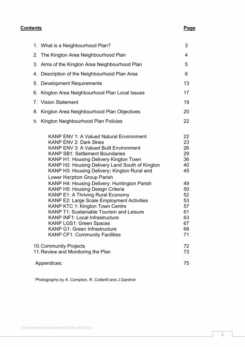
Contents Page
1 What is a Neighbourhood Plan 3
2 The Kington Area Neighbourhood Plan 4
3 Aims of the Kington Area Neighbourhood Plan 5
4 Description of the Neighbourhood Plan Area 6
5 Development Requirements 13
6 Kington Area Neighbourhood Plan Local Issues 17
7 Vision Statement 19
8 Kington Area Neighbourhood Plan Objectives 20
9 Kington Neighbourhood Plan Policies 22
KANP ENV 1 A Valued Natural Environment 22 KANP ENV 2 Dark Skies 23 KANP ENV 3 A Valued Built Environment 26 KANP SB1 Settlement Boundaries 29 KANP H1 Housing Delivery Kington Town 36 KANP H2 Housing Delivery Land South of Kington 40 KANP H3 Housing Delivery Kington Rural and 45 Lower Harpton Group Parish KANP H4 Housing Delivery Huntington Parish 49 KANP H5 Housing Design Criteria 50 KANP E1 A Thriving Rural Economy 52 KANP E2 Large Scale Employment Activities 53 KANP KTC 1 Kington Town Centre 57 KANP T1 Sustainable Tourism and Leisure 61 KANP INF1 Local Infrastructure 63 KANP LGS1 Green Spaces 67 KANP G1 Green Infrastructure 68 KANP CF1 Community Facilities 71
10Community Projects 72 11Review and Monitoring the Plan 73
Appendices 75
Photographs by A Compton R Cotterill and JGardner
KINGTON AREA NEIGHBOURHOOD PLAN 2019-2031
2
1 WHAT IS A NEIGHBOURHOOD PLAN
1 In 2011 Parliament agreed the Localism Act which devolved a number of powers to local communities including direct involvement in strategic planning This new power gives communities the opportunity to have more control over planning policy through the production of a Neighbourhood Development Plan (NDP) The Kington Area Neighbourhood Plan (KANP) must be in conformity with Herefordshire Councilrsquos Local Plan the Core Strategy (2011-2031) and with the National Planning Policy Framework (NPPF) The NDP should be acceptable to local people reflecting their needs and priorities and be supported by a local referendum Once adopted it will become part of the Countyrsquos development framework and all development proposals will need to conform to KANP Policies
KINGTON AREA NEIGHBOURHOOD PLAN 2019-2031
3
2 THE KINGTON AREA NEIGHBOURHOOD PLAN (KANP)
21 In 2013 Kington Town Council approved a Community-led Plan the Kington Local Acton Plan (KLAP) and shortly after decided to initiate an NDP
22 In 2013 the Councils of Kington Town Kington Rural amp Lower Harpton and Huntington joined together to produce a Neighbourhood Plan that would embrace all the areas of the constituent Councils A Steering Committee was formed comprised of Councillors from the three Councils to prepare a Draft Plan and to ensure that all local residents would be involved in consultations and invited to comment on drafts
23 The attached Consultation Statement details the varied methods of consultations used which included an interactive website wwwkingtonareaplanorguk articles in the Kington Chronicle public meetings questionnaires and drop-in sessions with displays
24 In June 2017 the Regulation 14 Draft Plan was completed During the six-week consultation period a questionnaire was distributed to every household in the neighbourhood together with a special edition of the Kington Chronicle and an exhibition in Kington Library Questionnaire responses and all other comments received were recorded and used to inform this revised version of the Plan now submitted under Regulation 16
KINGTON AREA NEIGHBOURHOOD PLAN 2019-2031
4
3 AIMS OF THE KINGTON AREA NEIGHBOURHOOD PLAN
31 This Neighbourhood Plan is intended to facilitate the development required by Herefordshire Council as stated in the Core Strategy whilst sustaining and improving the high quality townscape of Kington and the much valued landscape of the rural parishes in which it sits
32 In seeking to achieve this the aim is to build a community that will be resilient through implementing policies that support sustainability The KANP Policies on the Environment and Infrastructure are explicit but the goals of resilience and sustainability are central to how the community wishes to develop
33 A major focus in the Plan are Policies for meeting the housing obligations set by the Herefordshire Core Strategy The requirement was to provide sites for around 200 houses in Kington and a minimum of 32 dwellings in Kington Rural amp Lower Harpton Group Parish of which the NDP process has agreed 15 dwellings in the RA2 settlement of Hergest
34 The requirement to find sufficient sites while protecting the high-quality landscape surrounding Kington made this a very exacting task and necessitated compromises
35 Community consultations in Kington Town showed repeatedly that people prefer small housing sites rather than large estates This desire has been partially met but there is a dearth of such acceptable sites in an already densely built town that lies in an area with topographic and other constraints As a result about half the required numbers will be focused on one larger site The site was selected with advice from detailed assessments by specialists as being the least harmful position and one where the landscape impact could be minimized
36 The Plan contains Policies to support and sustain an economically viable neighbourhood that can offer some new employment possibilities In a rural largely agriculturally based area with limited forms of connectivity the aim is to encourage the growth of home-working tourism and the use of 21st century mechanisms of communication and distribution while protecting a very special environment
KINGTON AREA NEIGHBOURHOOD PLAN 2019-2031
5
4 DESCRIPTION OF NEIGHBOURHOOD PLAN AREA
41 The Plan area lies in north-west Herefordshire and is defined by the Parish boundaries of Kington Town Kington Rural amp Lower Harpton and Huntington It is bordered to the east by the Parishes of Lyonshall and Titley to the south by Eardisley Brilley and Michaelchurch and by Powys in Wales to the west A map of the KANP area is on the front cover
42 Kington Town is the smallest of Herefordshirersquos market towns with a population of just over 3000 Kington Rural amp Lower Harpton has a population of 463 and Huntington 93 Kington Town is an important service centre for its rural hinterland Kington Rural amp Lower Harpton are without any facilities except for one Community Hall at Kingswood Huntington village which contains the ruins of a castle was as important if not more important than Kington in the thirteenth century Huntington is now small but possesses a Village Hall two churches and a public house
43 The whole area lies in beautiful countryside that is part of an area accepted by Natural England as a strong candidate for designation as an Area of Outstanding Natural Beauty (AONB) This high-quality landscape setting is greatly valued locally However it creates challenges for the area in supporting rural regeneration as well as enhancing Kingtonrsquos role as a service centre and meeting its growth requirements A landscape assessment has been prepared as part of the Planrsquos evidence base (see Kington Area NDP Landscape Sensitivity amp Capacity Assessment) The town has 140 listed buildings Kington Rural amp Lower Harpton 9 and Huntington 12 (see Appendix 1 Listed Buildings)
44 Parts of the NDP area are remote and overall it is sparsely populated Access to services can be difficult but Kington and the Welsh towns of Hay on Wye and Presteigne play roles as service centres
45 The NDP area consists of upland hills from where narrow valleys broaden to flat-bottomed intensively farmed lower valleys and lowlands to the east where isolated grey stone farmsteads give way to villages more frequent hamlets and large farmsteads of stone and timber framed buildings
46 Herefordshire Councilrsquos Rural Housing Background Paper (March 2013) states that the Kington Rural Housing Market Area (HMA) has some of the lowest rural house prices in the County as well as one the highest proportions of second home ownership
47 The area has a somewhat different employment profile from that of Herefordshire as a whole Locally there are more self-employed people and more working in agriculture construction transport and accommodation than in the rest of Herefordshire and a greater number of people working in skilled trades While a proportion work in the Town or nearby many travel daily to other parts of Herefordshire or to Powys and further There is a higher proportion of residents aged 65+ than in the remainder of Herefordshire and a lower proportion of children
48 Recent statistics show that average earnings in Herefordshire are 14 lower than the average for the West Midlands and 21 lower than in England with a large gender pay gap Houses at the lower end of the market cost 84 times the average earnings of lower earners The County has the worst housing lsquoaffordabilityrsquo level of all West Midlands authorities there is an obvious need for subsidised housing
KINGTON AREA NEIGHBOURHOOD PLAN 2019-2031
6
While the Kington neighbourhood is not one of the 25 of most deprived areas in England as is nearby Leominster it is not anywhere near the most prosperous
49 In Herefordshire the industries that currently employ the largest number of people are manufacturing health retail and education a pattern that is not replicated in the Kington Neighbourhood Plan Area Although locally a slightly larger percentage is employed in agriculture when compared with the county as a whole the numbers are relatively very small Kington is a small Market Town surrounded by farms and related enterprises so categories of work such as transport and social care are being supported by agriculture
410 The Kington Stock Market operates with a good trade in sheep weekly and in cattle monthly It is the only Market Town in Herefordshire apart from Hereford City where a Stock Market still flourishes
411 Kington Horse Show and Agricultural Society Show which takes place every September is one of the largest one-day shows in the County providing a showcase for traditional agriculture with livestock and horticulture competitions as well as family entertainment and shopping opportunities
412 A more detailed description is provided below of Kington Town the Parishes of Kington Rural Lower Harpton and Huntington
Kington Town
413 Kington lies 20 miles (32 km) from the border with Wales and despite being on the western side of Offarsquos Dyke has been English for over a thousand years The town is in the shadow of Hergest Ridge and on the River Arrow where it is crossed by the A44 road It is 19 miles (31km) north-west of Hereford the county town Nearby towns include Presteigne Builth Wells Knighton and Leominster The A44 heads around the town on a by-pass it previously went through the town centre
414 In the 11th century Kington had a castle which was sited to the north-west of the present town on Castle Hill above the Back Brook All that remains of Kington Castle today is a great outcrop of rock topped by a few fragmentary earthworks The old town clustered round the castle and the nearby Norman Church on top of a defensive hill In the 13th Century the new medieval town was formed to the south-east of the hill and became primarily a wool-trading market town on an important droverrsquos road
415 Kington today is an unspoilt market town with a population of 3300 (mid 2011) The town retains the medieval grid pattern of streets and back lanes with its town centre dominated by the Victorian red brick market hall (1885) The busy High Street provides the retail focus for the town and is occupied by a number of independent stores In addition the town has the Burton Hotel three medium-sized supermarkets in the town centre as well as a livestock market a regular local Friday food market and Saturday craft markets The River Arrow and its flood plains are located to the south of the town centre
416 Kington has a Conservation Area which was designated in 1969 (see Map) The Conservation Area includes unique features including high stone walls that stand on the boundary lines of medieval burgage plots and now delineate pedestrian lanes Eight Character areas have been defined within and adjoining the Conservation
KINGTON AREA NEIGHBOURHOOD PLAN 2019-2031
7
Area These include the Town Centre River Meadows Church Hill and Crooked Well The town has many listed buildings as well as unlisted buildings of local interest
417 The town also has St Marys Church a Baptist Chapel St Bedersquos Catholic Church Kingdom Hall the Kington Museum a cricket ground and a football ground where Kington FC play Kington Golf Club is located at 1100 feet (340 m) on Bradnor Hill making it the highest golf course in England On the edge of the town are Hergest Croft Gardens and Arboretum of national importance
418 The town has a primary school and a secondary school the Lady Hawkinsrsquo School
419 Aptly named lsquoa centre for walkingrsquo Kington carries lsquoWalkers Are Welcomersquo status hosting its own Walking Festival Kington Walks every September The Town is situated close to the Offarsquos Dyke Path The Mortimer Trail The Arrow Valley Trail The Herefordshire Trail and The Wyche Way all long-distance footpaths
Kington Rural and Lower Harpton
420 The two Parishes of Kington Rural and Lower Harpton are combined into a single local government area Together they form the rural hinterland of Kington Town which lies on the eastern edge of Kington Rural and abutting the parish boundary of Lyonshall In landscape terms Kington Rural forms the backdrop for Kington Town the hills and woods that create an envelope round the Town are much-valued by everyone in the whole neighbourhood especially Hergest Ridge and Bradnor Hill both topographically significant features in the landscape
421 Both Lower Harpton and Kington Rural share their western boundaries with Wales Lower Harpton is about one third the size of Kington Rural and lies on its north-west edge Both parishes are rural with some clusters of dwellings scattered farmsteads houses or cottages None of the clusters now have any facilities such as a school shop pub or church except one well-used Community Hall at Kingswood within Kington Rural
422 The A44 runs eastwest through Kington Rural and on the southern edge of Lower Harpton the A4111 going south from Kington is close to the eastern edge of Kington Rural Public transport consists of a regular weekday bus service from Kington westwards to Llandrindod Wells and southwards to Hereford For people in both parishes Kington is where they shop visit the surgery go to school and use other facilities such as the Library the petrol station and the busy livestock market
423 The parish of Lower Harpton has 28 on the electoral roll Bradnor Hill rises steeply on its eastern boundary while Herrock Hill rising to 371m is a prominent feature in the north east of the parish The parish boundary at the south-east end skirts the eastern edge of Stanner Rocks a site of Special Scientific Interest (SSSI) Herrock Hill is grazed by sheep while most of the lower land is made up of fields bounded by hedgerows much of it pasture but with some arable and a few small stands of trees The sole continuous route through the area is an unclassified north-south track The two largest houses are Lower Harpton Farm and Dunfield House the latter listed grade 11
424 About one third of the parish of Kington Rural lies to the north and north-west of Kington and separated from the other two thirds to the south and south-west of Kington by a valley along which runs the A44 and the Back Brook Bradnor Hill
KINGTON AREA NEIGHBOURHOOD PLAN 2019-2031
8
(371m) in the northern part and Hergest Ridge (426m) to the south have the same geological origins The Back Brook runs from west to east joining the River Arrow on the east side of Kington Kington Rural Parish has 460 people on the electoral roll
425 The A4111 a route from Kington to Hereford via Eardisley lies towards the eastern edge of the parish The C1072 leaves Kington near the parish church and runs south-westwards along the valley of the River Arrow Other roads are minor ones some only single track
426 Bradnor Hill contains old stone quarry workings one of which is a designated SSSI Both Hergest Ridge and Bradnor Hill are designated Local Wildlife Sites (LWSs) and are open upland rough grazing land supporting flocks of sheep and on Hergest ponies The remainder of the land in the parish is principally farmed pasture with some arable and some significant areas of woodland
427 Much of the parish consists of undulating hills and valleys with the relatively sparse population either in isolated farms or in small settlements The principal settlements are the hamlets of Rushock about one mile east of Kington Bradnor a similar distance to the north of the town and Floodgates with Newton and Wallstych Lanes to the north-west of the town and separated from it by the A44 To the west are Lower and Upper Hergest and to the south Kingswood which contains Pembers Oak Lilwall and Chickward
428 The only settlement with any facility beyond a post box is Kingswood with a Community Hall
429 The farms in the parish vary in size but none would be classified as large most are owner-occupied or with long-term tenants The whole area is characterised by an intricate pattern of fields bounded by hedgerows many containing fairly old trees
430 Local people express a deep attachment and appreciation of the rural area and attribute its character to the existence of small farms many having been continuously worked by succeeding generations of the same family Ownership of such a heritage is both emotional and economic It is attractive also to people from elsewhere who enjoy walking cycling and have an interest in the countryside They stay in local Bed and Breakfast or self-catering accommodation
431 There are several woodlands registered as Ancient or Ancient and Replanted Kennel Wood to the north of Rushock Park Wood which is part of the Hergest Estate to the west of Kington and six sections of Kingswood to the south of Kington
432 Kingswood on land rising southwards from the Arrow Valley to about 255m was for several centuries covered by large areas of woodland gradually cleared during the middle of the 19th century when the Enclosures Act resulted in much of it being sold and partitioned The six currently designated sections of woodland are survivors and contain many fine specimens of native trees some of which show evidence of old pollarding regimes The Birches Farm in the southern tip of Kingswood is a registered SSSI now owned by the Herefordshire Wildlife Trust and being farmed to high ecological standards so as to sustain the rich flora and fauna in the fields and hedgerows Some fields in Kingswood formed as a result of woodland cleared by the Enclosures Act are noticeably rectangular contrasting with the older smaller fields with sinuous boundaries
KINGTON AREA NEIGHBOURHOOD PLAN 2019-2031
9
433 There are some notable very old timber-framed farmhouses which point to the durability of local materials well-crafted Others are built of locally produced bricks
434 Kingswood has a Community Hall and an annual popular Kingswood Show The Small Breeds Farm and Owl Sanctuary is a tourist attraction
435 The whole parish has a large number of public footpaths many well used Some of them are on ancient lsquogreen lanesrsquo lsquosunkenrsquo lanes and old routes connecting farms and settlements some identified as droving roads used when large flocks of sheep cattle or geese were driven from mid Wales to England Several fields in Kingswood used to be common land where large flocks were held watered at Moseley Mere and rested before moving on initially on foot but later by rail from Kington Station Sections of the long-distance popular pathways Offarsquos Dyke Path the Herefordshire Way and the Mortimer Trail pass through the area
436 Lower Hergest contains Arrow Court Industrial Estate the site of a large World War Two (WW11) Army Camp and American Field Hospital A number of the camp buildings have been converted into small work units for light industry and it is designated employment land On the opposite side of the road is a large turkeyndash rearing complex A small number of individual dwellings are nearby but the largest cluster of houses is Arrow View some 20 houses built in the post-war period initially intended for low-cost tenancies
437 The grade 11 listed Hergest Court sits on a prominent bluff just off the road Its origins pre-date the 15th century with locally prominent owners one of whom held the Red Book of Hergest one of the most important Welsh manuscripts of the Middle Ages containing poetry and prose including The Mabinogion
KINGTON AREA NEIGHBOURHOOD PLAN 2019-2031
10
Huntington Parish
438 The Parish of Huntington is in a remote and sparsely populated area on the western fringe of Herefordshire some 4 miles south-west from Kington bordering Wales The parish is of high landscape quality as shown by the detailed landscape evaluation with the western Section being considered for designation as an Area of Outstanding Natural Beauty The area in the past has been considered for inclusion in the Brecon Beacons National Park
439 Huntington is very much a rural parish of some 47 dwellings and 93 residents there are no specific centres of population or concentrations of dwellings with properties being widely spread throughout the parish The parish has approximately 780 hectares of land which is bisected by the River Arrow the majority of land usage is grazing and arable interspersed with pockets of woodland The population density is 01 persons per hectare which is very low in comparison to Herefordshire generally at 08 persons per hectare
440 There are 8 farm businesses and a number of small-holdings within the parish Agriculture is by far the largest employment sector with income being mainly derived from cattle and sheep with some arable farming In order to diversify cherries grown under polytunnels have been introduced by two farmers in the last few years Parishioners are generally fully aware of the importance of farming and in the parish questionnaire 96 of respondents felt that family farms should remain a feature of the community
441 The rural nature of the parish with its unspoiled beauty and tranquillity is much appreciated by parishioners and visitors alike with a number of popular footpaths and bridleways throughout the parish being enjoyed by many Huntingtons
KINGTON AREA NEIGHBOURHOOD PLAN 2019-2031
11
landscape ever-changing with the seasons is a managed rather than a wild countryside consisting of a patchwork of fields woods and hedges intersected by brooks paths and lanes There are excellent views from many vantage points throughout the parish of the Black Mountains in Brecknok Hergest Ridge in Herefordshire The Malverns in Worcestershire Clee Hill in Shropshire and May Hill in Gloucestershire The parish questionnaire identified areas of specific historical and environmental importance such as the Castle the Chapel the Church Rainbow Meadow and the River Arrow and its Water Meadows
442 Huntington has a very strong community identity and spirit Unusually for its size it still retains a Public House a modern Village Hall as well as a Church and Chapel Village events such as the annual Huntington Fete are always enthusiastically supported by parishioners
443 The parish questionnaire was completed by 51 of the 89 parishioners on the Electoral Roll giving a very positive attitude and response about the parish and an understanding that the Neighbourhood Plan gives everyone an opportunity to look carefully at what needs to be done for the future of Huntington The questionnaire also highlighted that a large proportion of people do their main food shopping in Kington Other facilities in Kington used on a regular basis include the Surgery Post Office library livestock market and recreation ground Clearly the economy of Kington is linked to that of Huntington
444 Whilst the population numbers have remained stable over the last decade the average age is increasing as young people have been unable to find local employment or to move into the village due to a combination of high property prices and planning constraints on new development Parishioners primarily fall into four groups a rather small number of young people 18 or under approximately 6 people living and working in the parish - predominately farming people living in the parish and working elsewhere and retired people living in the parish for quality of life reasons
445 Houses are in the main either of traditional stone construction or traditional timber-framed with slate or tiled roofs Most properties are two-storey and are generally owner-occupied with one property being utilised as a second home In the parish questionnaire 34 people stated that any new properties should be in keeping with existing buildings and 26 people stated local materials and traditions should be used There are 13 Grade II Listed Buildings and scheduled Monuments in the parish including
bull K6 telephone kiosk adjacent to the Old Post Office bull Goffs Endowed School bull Huntington United Reformed Church bull Church of St Thomas a Beckett bull Remains of Huntington Castle
KINGTON AREA NEIGHBOURHOOD PLAN 2019-2031
12
5 DEVELOPMENT REQUIREMENTS
51 The Herefordshire Council adopted Local Plan Core Strategy provides the framework for future land use and development within the County for the period 2011-2031 This KANP has been prepared to meet the development requirements of the Core Strategy that apply to the Kington Area Neighbourhood It must and does comply with all the Policies identified in the Core Strategy
52 The Core Strategy vision for Kington Town places significant emphasis upon the creation of new homes including affordable housing employment opportunities delivery of and access to services reducing the need to travel to other centres and utilising the natural and historic environment as economic assets all within significant environmental and locational constraints
53 The Core Strategy identifies in Policy KG1 the following development requirements to be delivered in Kington Town over the period 2011 to 2031 and places responsibility for meeting the requirements on the Neighbourhood Plan
KINGTON AREA NEIGHBOURHOOD PLAN 2019-2031
13
Core Strategy Policy KG1 ndash Development in Kington
Kington will accommodate around 200 new homes during the plan period A Neighbourhood Development Plan will allocate sites to meet this level of housing In addition provision for new employment uses should be brought forward to meet needs from within the Kington and West Herefordshire Housing Sub-Market Area Development proposals for Kington will be encouraged where they
bull deliver affordable housing in accordance with the requirements of Policy H1
bull provide a mix of market and affordable house sizes and types that meet the requirements of Policy H3 and the needs identified in the latest version of the Herefordshire Local Housing Market Assessment
bull enable an overall density of up to 35 dwellings per hectare bull enable home working bull make available small-scale employment sites brought forward in
balance with housing within the Kington and West Herefordshire Housing Sub-Market Area
bull maintain and enhance the vitality and viability of the town centre Proposals for new retail leisure or office development of over 200m2 in gross floor space and located outside the defined town centre will need to be supported by an impact assessment in accordance with the National Planning Policy Framework to determine whether there could be any adverse impacts on the vitality and viability of the Kington town centre
bull make provision for green infrastructure and amenity space including play facilities community access to open space and the linking of habitats into ecological networks within and surrounding the town
bull make provision for or improve walking and cycling links to the town centre schools shopping and employment
bull protect conserve and where possible enhance the historic character of Kington in particular the Conservation Area and its significance and setting including particular features its heritage assets important buildings scenic views and the landscape features surrounding the town and
bull have demonstrated engagement and consultation with the community including the townparish council
KINGTON AREA NEIGHBOURHOOD PLAN 2019-2031
14
54 In addition the KANP area includes a significant rural hinterland which embraces the Parishes of Kington Rural Lower Harpton and Huntington Core Strategy Policy RA1 Rural housing distribution locates the KANP rural area in the Kington Housing Market Area (HMA) which has an approximate overall target of 317 new dwellings to be provided by 2031
55 Within the Kington HMA the Kington Rural and Lower Harpton Group Parish is required to provide sites to accommodate an additional 32 dwellings with Policy RA2 of the Core Strategy identifying the settlement of Hergest as a sustainable location where proportionate housing growth is appropriate In addition Arrow Court Industrial Estate (Hergest Camp) provides employment provision
56 Outside of the identified settlement boundaries of Kington Town and Hergest in the remaining areas of Kington Rural and Lower Harpton Group Parish and Huntington Parish residential development will be limited to proposals that satisfy one or more of the following criteria as detailed in Policies RA3 RA4 and RA5 of the Core Strategy
bull homes that meet an agricultural or forestry need bull deliver other farm diversification enterprise(s) for a worker to live permanently at or
near their place of work bull are necessary to support a rural enterprise to be retained or grow (such homes
need to comply with all elements of policy RA3 and RA4 of the Core Strategy) bull replacement of existing dwellings bull re-use of redundant or disused buildings where it complies with Policy RA3 and
RA5 bull rural exception sites ndash small affordable housing schemes that meet proven local
needs in accordance with Policy RA3 and Policy H2 bull is of exceptional quality and innovative design meeting criteria as specified in
paragraph 55 of the National Planning Policy Framework (NPPF) and achieves sustainable standards of design and construction
57 In summary and in accordance with the Core Strategy the KANP needs to deliver the following development requirements
Kington Town bull Maintain and where possible enhance its role in providing services and facilities to
its hinterland bull Deliver around 200 new homes between 2011-2031 phasing will be necessary to
overcome current infrastructure constraints bull Mix and type of housing to include Affordable Housing (target of 35) to meet
identified needs including those of older people bull Identified sites with the least impact on the landscape bull Support and encourage further opportunities for employment growth at Hatton
Gardens bull Support small-scale employment proposals bought forward in balance with housing
and a flexible approach to home working bull Maintain and enhance the vitality and viability of the town centre as a location for
shops supported by service and tourism facilities bull Provide green infrastructure and amenity space with more open space required bull Support the current provision of community facilities bull Improve walking and cycling links bull Maintain and enhance the character of Kington
KINGTON AREA NEIGHBOURHOOD PLAN 2019-2031
15
Kington Rural amp Lower Harpton Group Parish
bull Deliver a minimum of 32 new homes between 2011-2031 of which Hergest is identified as a settlement where proportionate housing is appropriate
bull Safeguard existing employment land at Arrow Court Industrial Estate
Huntington Parish
bull There are no specified development requirements to be delivered in the rural Parish of Huntington Windfall development will be permitted where it accords with the polices of the Core Strategy and the KANP
KINGTON AREA NEIGHBOURHOOD PLAN 2019-2031
16
6 KINGTON AREA NEIGHBOURHOOD PLAN LOCAL ISSUES
61 Following consultation with the local community the following list of local issues were identified for further consideration in the KANP
bull Protect and enhance the local environment bull Address an ageing population and loss of young people bull Deliver a strong resilient rural community bull Maintain and continue to strengthen a good local community spirit bull Protect community facilities bull Build on previously developed land where possible bull Identify and protect Local Green Spaces from development bull Deliver energy efficient housing to meet local needs including affordable homes bull Ensure homes are designed sympathetically using local materials and traditions bull Deliver homes with good-sized gardens and room sizes as well as off-road
parking bull Address the lack of job opportunities and support rural regeneration through the
provision of affordable business premises live-work units and home working bull Support farming to help retain young people and families in the area bull Recognise the importance of agriculture to the economic future of the area bull Ensure local infrastructure is able to accommodate future development ndash utilities
flooding local services bull Enhance the role of Kington Town and its connectivity as a service centre meeting
the needs of its rural hinterland bull Improve the environment of the High Street in Kington and make it more
pedestrian friendly bull Provide linked circular safe cycling and walking routes around Kington and the
wider area bull Safeguard employment land at Hatton Gardens and Arrow Court Industrial Estate
KINGTON AREA NEIGHBOURHOOD PLAN 2019-2031
17
bull Develop Kington as a Walking Centre to support Tourism bull Improve play facilities at Hatton Gardens Crooked Well Meadow and the
Recreation Ground bull Recognise the need for more facilities for younger people including a modern
internet cafeacute venue for watching films restore the youth club
KINGTON AREA NEIGHBOURHOOD PLAN 2019-2031
18
7 KINGTON AREA NEIGHBOURHOOD PLAN VISION STATEMENT
71 The vision for the Kington Neighbourhood Area in 2031 is
Kington Town and the Parishes of Kington Rural Lower Harpton and Huntington will be vibrant rural communities which have delivered managed growth to meet the arearsquos needs whilst balancing this with protection of its high quality environmental setting and will have
bull Thriving rural communities with sustainable futures which are living in harmony with their valued rural environment
bull Retained and enhanced the arearsquos strong community identity and spirit
bull Enhanced and strengthened the role and function of Kington Town as a service centre serving its rural hinterland
bull Delivered new sustainable homes in locations agreed locally with a range of types sizes and tenures appropriate for the varied needs of local people
bull Delivered a robust rural economy which has delivered successful farming supported home working whilst attracting new business and has encouraged young members of the community to gain employment locally and remain within the area
bull Increased the proportion of new sensitively designed development built to a high quality design which enhances the areas setting and delivers high energy efficiency standards
bull Local infrastructure improvements including delivery of an improved Broadband and Mobile phone service suitable for the community
bull A wide range of community facilities serving the local community
KINGTON AREA NEIGHBOURHOOD PLAN 2019-2031
19
8 KINGTON AREA NEIGHBOURHOOD PLAN OBJECTIVES
81 To deliver this KANP vision the following Plan objectives were identified
KANP Objective 1
To protect and enhance the local natural environment for the benefit of future generations - air and water quality green and open spaces woodland and hedgerows wildlife footpaths and cycleways and views
KANP Objective 2
To protect and enhance the local built environment through well-designed sustainable buildings which reflect local building traditions and minimise light pollution ensuring protection of the lsquoDark Skiesrsquo
KANP Objective 3
To provide managed housing growth within the KANP area to meet the requirements of the Core Strategy which include a range of housing to meet the needs of local people that is well-designed of a sustainable construction and is located to ensure protection of the rural character of the area
KANP Objective 4
To deliver the highest standard of design that will respect the scale style and setting of the historic townscape and the rural landscape
KANP Objective 5
To protect and enhance the role and function of Kington Town as a service centre for its rural hinterland
KANP Objective 6
To reduce the impact of traffic in Kington High Street make it more pedestrian friendly with safer routes and improved connectivity for cyclists and pedestrians
KANP Objective 7
To promote Kington and its hinterland as a location which promotes small businesses supports farming and its diversification and encourages young members of the community to seek employment locally and remain in the area
KANP Objective 8
To manage effectively the development of large-scale farming unitspolytunnelsintensive livestock units to ensure protection of the local environment and the amenity of local residents
KINGTON AREA NEIGHBOURHOOD PLAN 2019-2031
20
KANP Objective 9
To support sustainable green tourism through small-scale tourism developments and provision of suitable tourist accommodation
KANP Objective 10
To ensure important green spaces are designated as Local Green Spaces
KANP Objective 11
To develop and enhance the green infrastructure provision in Kington linking the Town to the countryside beyond
KANP Objective 12
To improve local infrastructure including broadband and mobile phone coverage across the entire neighbourhood to assist local businesses and residents
KANP Objective 13
To ensure that development proposals take full account of the potential for flooding and management of surface water through alleviation measures so that new development does not exacerbate the likelihood of flooding on surrounding land
KANP Objective 14
To encourage and enhance the use of all community facilities in order that they continue to thrive and cater for the needs of all age groups
KANP Objective 15
To provide support for small -scale renewable energy opportunities linked to individual developments for private or local community use
82 The following section of the Plan identifies specific policies that are intended to deliver the plan objectives and overall vision These policies have arisen from the information provided by the residents of Kington Town and the Rural Parishes at the various consultation events These policies need to be read in conjunction with the adopted (October 2015) Herefordshire Core Strategy and National Planning Policy Framework Collectively these documents provide the Local Development Framework for the area and contain the policies which will guide and inform future development in the KANP area
KINGTON AREA NEIGHBOURHOOD PLAN 2019-2031
21
9 KINGTON AREA NEIGHBOURHOOD PLAN POLICIES
91 Natural Environment
Consultation Feedback
Underpinning all aspects of this Neighbourhood Plan is the overall desire to preserve and enhance the natural environment of the KANP area
Residents have responded by saying that the on-going preservation and enhancement of the arearsquos attractive and valued rural environment are important and will continue to enhance their quality of life
Of particular interest are
bull two designated sites Hergest Ridge and Bradnor Hill bull the general topography of small fields hedgerows with hedgerow trees veteran
trees and stands of woodland and ponds bull the valleys and waters of the River Arrow and the Back Brook together with the
flora fauna and trees of the river banks bull the distant and near views of the landscape especially from Hergest Ridge
Bradnor Hill Kingswood and areas within Huntington bull the relatively high proportion of pasturegrazing land that provides habitats for
plants birds and insects that diminish when arable becomes dominant bull narrow lanes with high hedges and banks providing rich corridors of biodiversity bull the ability to access much of the countryside that is much appreciated
Policy KANP ENV1 - A Valued Natural Environment
Development proposals will be required to conserve and protect the valued tranquil natural environment of the KANP area by
(i) protecting and enhancing the River Arrow and the Back Brook from the impacts of development
(ii) respecting protecting and enhancing important open spaces views and the arearsquos landscape quality as identified in the Character Appraisal-Kington (February 2016) and the Kington Area Landscape Sensitivity and Capacity Assessment (October 2015)
(iii) respecting topography and not being visible against the skyline when seen from a distance whether the development be residential agricultural or industrial
(iv) conserving protecting and enhancing local habitats and areas of biodiversity value
(v) conserving and protecting woodlands and smaller stands of native trees (vi) conserving and protecting mature trees and hedgerows and incorporating
these features into landscaping schemes (vii) planting a high proportion of native treehedge species within any new (viii) development (ix) protecting and enhancing local orchards from development and (x) protecting existing geodiversity
KINGTON AREA NEIGHBOURHOOD PLAN 2019-2031
22
Policy KANP ENV 2 ndash Dark Skies
To reduce light pollution and to improve the views of our night-time skies planning proposals that include external lighting will be required to demonstrate the following
(i) the nature of the proposed lighting is appropriate for its use and location and has minimal impact
(ii) the proposed lighting does not materially alter light levels outside of the development which will adversely affect the use or enjoyment of nearby buildings or open spaces
(iii) the proposed lighting does not impact upon highway safety within the locality and
(iv) the proposed lighting does not have a significant impact on protected species or wildlife within the locality
Policy Justification
911 The Plan will seek to preserve and enhance the KANP arearsquos attractive and valued natural environment
912 The KANP area is made up of enclosed moors and commons ancient timbered farmlands ancient border farmlands wooded hills and farmlands high moors and commons hills with long distance views looking west towards Wales east and south towards other parts of Herefordshire and beyond The KANP will seek to protect and enhance this valued environment for its biodiversity interest and for future generations to enjoy
913 Of note there is (see Appendices 6 amp 7)
bull The River Arrow bull The Back Brook bull 5 SSSIrsquos bull 51 Special Wildlife Sites bull 20 ancient woodlands bull 3 Registered Parks amp Gardens and 10 Unregistered Parks amp Gardens
914 Kington Town has many landscape features Most notable of these are the River Arrow the Back Brook and the valley walls at the base of which is the town settlement The River Arrow and Back Brook provide bank-side habitats which deliver strong biodiversity linkages around and through the town
915 The River Arrow feeds into the River Lugg a Special Site of Scientific Interest (SSSI) which in turn contributes to the River Wye which is a Special Area of Conservation (SAC) and an (SSSI) A SAC is designated under the Habitats Directive and is identified as being of European importance and therefore must be protected
916 To ensure on-going protection and enhancement of the natural environment a Characterisation Assessment has been prepared in 2016 for Kington Town as part
KINGTON AREA NEIGHBOURHOOD PLAN 2019-2031
23
of the evidence to support the policies contained in the KANP This study has identified important open spaces views and landscape features which need to be protected from development they are listed and indicated in the report by OHA Architects Character Appraisal-Kington The Landscape Sensitivity and Capacity Assessment report by Carly Tinkler provided an appraisal of the rural areas including those surrounding Kington Town
KINGTON AREA NEIGHBOURHOOD PLAN 2019-2031
24
92 Built Environment
Consultation Feedback
bull Strong support for use of materials that are either lsquolocalrsquo eg stone lsquotraditionalrsquo eg timber framed rendered exteriors or of similar type to those found in older parts of the town in contrast there is dislike of non-mellow redbrick and lsquoaggressiversquo roofs This received support from the report commissioned from OHA (see Appendix)
bull A desire to maintain the lsquocharacter of the older building styles and materials so that the town is distinctive and does not become something that can be found anywhere in the country (Kington Local Action Plan Survey Report June 2013)
bull March 2014 public meeting on housing produced similar comments Additional comments that lsquogood quality lsquomodernrsquo design can be acceptable if architects design in sympathy with the existing environment
bull An appreciation and concern for the maintenance of the existing town centre and its historic structure and buildings Main part of the town is laid out on a medieval linear grid pattern with the High Street running eastwest and the housing plots developed from it running northsouth the plots and the old town boundary were marked by boundary walls the burgage walls uniquely made of stone which has been the local building material for centuries These are a special feature of Kington with the alleyslanes allowing pedestrian access to the High Street
bull The walls are suffering from neglect and in a number of places have been breached The better maintenance of the walls is strongly supported They are in the Conservation Area but there is a desire for them to have the further protection of listed status
bull The High Street used to be the main droving road along which stock was driven entries to dwellings was from the rear and not from the street sides some buildings retain the railings on their fronts to guard against damage from animals
bull The designated Conservation Area is considered to be too limited there is strong support for extending it to the east end of Victoria Road to include the historic foundry building and also at the north-west end beyond the parish church to the site of the castle mound (see Conservation Area Plan in Appendix)This latter area is considered to be where the original settlement was located near the Back Brook and the castle and the route westwards into Wales
KINGTON AREA NEIGHBOURHOOD PLAN 2019-2031
25
Policy KANP ENV3 - A Valued Built Environment
Development proposals will be required to conserve protect and where possible enhance the heritage assets and the wider historic environment of the Kington KANP area by
(i) demonstrating that the proposed development does not substantially harm designated heritage assets
(ii) where proposals lead to less than substantial harm to the heritage asset this should be weighed against the public benefits of permitting them
(iii) presenting a balanced judgement of the scale of harm to and significance of non-designated heritage assets
(iv) respecting and conserving both individual buildings and groups of buildings with functional connections
(v) respecting conserving and where possible enhancing the setting of nationally and locally historically significant buildings and registered heritage assets
(vi) taking every opportunity through design and materials to reinforce local distinctiveness and a strong sense of place incorporating local heritage features as set out in AppendiX 3
(vii) conserving and enhancing the significance of the Kington Town Conservation Area such that it can be removed from the national Heritage at Risk Register
(viii) conserving and respecting the historic Burgage walls of Kington Town and acknowledging them as non-designated heritage assets and
(ix) taking full account of known surface and sub-surface archaeology and ensuring unknown and potentially significant deposits are identified and appropriately considered during development after consultation with the Historic Environmental Record (HER) Lack of current evidence of sub-surface archaeology must not be taken as proof of absence
Policy Justification
921 There are numerous listed buildings within the KANP area and fourteen Scheduled Ancient Monuments (SAMs) Within Huntington there are several SAMs currently recorded in the Buildings at Risk Register (Turret Trump at Huntington Turret Castle Huntington Castle) Huntington Castle is also a grade 2 listed building at risk In the Rural Areas there are some notable listed farmhouses (see Appendix 1)
922 Kington Town has a Conservation Area which was designated in 1969 This designation seeks to protect the Townrsquos natural and historic assets The Conservation Arearsquos special architectural and historic significance is based upon its historic development with the Town dating back to the 12th century The medieval period is largely responsible for its oldest buildings but during the 18th
KINGTON AREA NEIGHBOURHOOD PLAN 2019-2031
26
century many earlier timber-framed structures were re-fronted encased or replaced by Classically-inspired Georgian facades
923 Today the essential character of the Conservation Area is that of a small historic market town with a tight urban grain The town centre buildings are predominantly three stories tall constructed using a mixture of coursed and natural stonework painted brickwork white render painted timber sash windows and doors and slate roofs with brick chimney stacks It is a concern that the Conservation Area is currently on the national Heritage at Risk Register
924 A particular feature of the Town is its town centre burgage boundary walls that also delineate pedestrian lanes which are an important element of the medieval town plan and help to establish the atmosphere and experience of Kington
925 To ensure on-going protection and enhancement of the built environment of the plan area the Character Appraisal-Kington (February 2016) has been prepared for Kington Town as part of the evidence to support the policies contained in the KANP This study has identified important key heritage features which should be protected and taken forward and included within future schemes A list of these heritage features is provided in the OHA report This will help ensure successful integration of new build within the built form of the area whilst protecting its special character
KINGTON AREA NEIGHBOURHOOD PLAN 2019-2031
27
93 Settlement Boundaries Kington Town and Hergest
Consultation Feedback
Kington Town
A settlement boundary for Kington Town was established in the Herefordshire Unitary Development Plan (2007) The AECOM Site Options and Assessment (2015) report which forms a background report to the KANP reviewed potential sites within and adjacent to Kington Town Much of the UDP boundary is retained but with amendments made on the east north and south of the town as follows
bull to the south extensions will now include the ldquoLand South of Kingtonrdquo and a green buffer space
bull to the north it will follow the parish boundary more closely bull to the east it will follow the parish boundary near the A411 and the building line to
the north and south of the River Arrow
This revised settlement boundary was discussed and agreed at the Town Council meeting on November 6th 2017 (See Plan 1)
Hergest
Following the decision to allocate the site adjacent to Arrow View for housing a settlement boundary was defined to include this site the existing housing estate Arrow View and the adjacent fields This was agreed by Kington Rural Parish Council on May 18th 2017 (see Plan 2)
KINGTON AREA NEIGHBOURHOOD PLAN 2019-2031
28
Policy KANP SB1 - Settlement Boundaries Kington Town and Hergest
Kington Town
In accordance with Policy KG1 of the Core Strategy and to meet the housing needs of all sections of the community the settlement of Kington will accommodate around 200 new homes during the plan period To deliver this growth a Settlement Boundary has been defined for Kington Town as shown in Plan 1 Development proposals will be directed to sites that fall within this boundary in accordance with other relevant policies of this Plan
Hergest
In accordance with Core Strategy Policy RA2 the settlement of Hergest will act as a focus for development to meet the needs of Kington Rural amp Lower Harpton Group Parish and to contribute to the target set for the Kington Housing Market Area To deliver this growth a Settlement Boundary has been defined for Hergest as shown in Plan 2 Development proposals will be directed to sites that fall within this boundary in accordance with other relevant policies of this Plan
Rural Areas
Outside the two defined settlement boundaries housing proposals will need to comply with Herefordshire Core Strategy policies Policy H2 - Rural Exception Sites Policy RA3 - Dwellings in Herefordshirersquos Countryside Policy RA4- Agricultural Forestry and Rural Enterprise Dwellings and Policy RA5 - Re-use of Redundant Rural Buildings
KINGTON AREA NEIGHBOURHOOD PLAN 2019-2031
29
Plan 1
KINGTON AREA NEIGHBOURHOOD PLAN 2019-2031
30
Plan 2
KINGTON AREA NEIGHBOURHOOD PLAN 2019-2031
31
Policy Justification
931 As one of the Countyrsquos five market towns Policy KG1 of the Core Strategy identifies the settlement of Kington as a focus for growth to accommodate around 200 new homes to meet local housing requirements deliver affordable housing and help support the services and facilities of the town centre
932 Policy RA2 of the Core Strategy identifies the settlement of Hergest as a focus for growth to meet the needs of Kington Rural and Lower Harpton Group Parish
933 Settlement Boundaries have been drawn to define the limits for development for Kington Town and Hergest Within these boundaries there is a general presumption in favour of development whilst land and buildings outside the boundaries are subject to a more restricted approach to development in order to safeguard and protect the valued countryside
934 The Parish of Huntington does not have an identified settlement so is regarded as open countryside with development limited to specific circumstances as detailed in Policies RA3 RA4 and RA5 of the Core Strategy
935 For Kington Town a previous settlement boundary was included in the adopted Herefordshire UDP This UDP boundary has been taken as the starting point for the KANP and reviewed using the following criteria
(i) Lines of communication ndash the boundary traces the edge of the built-up area and should exclude roads paths railways and other lines of communication
(ii) Physical features ndash the boundary follows physical features including buildings field boundaries and curtilages However in order to conserve the character and to limit expansion settlement boundaries can exclude large gardens orchards and other areas
(iii) Planning History ndash The boundary has been drawn to reflect planning decisions including existing commenced planning permissions and new developments
(iv) Town enhancements ndash Land and buildings have been included which contribute and make up the town form or offer the opportunity for improvements
(v) Important amenity areas ndash Important amenity areas which form part of the character of the settlement have been identified protected by policy and included in the settlement boundary due to their contribution to built form
(vi) Potential allocations
936 Taking on board the criteria above the proposed settlement boundary for Kington Town as identified in Plan 1 reflects the previous UDP boundary line the Parish Boundary and the main building lines with further amendments (see Consultation section above)
KINGTON AREA NEIGHBOURHOOD PLAN 2019-2031
32
937 The settlement of Hergest previously has not had a designated Settlement Boundary One has been drawn through the KANP process following the above criteria as shown on Plan 2
KINGTON AREA NEIGHBOURHOOD PLAN 2019-2031
33
94 Housing Delivery
Consultation Feedback
Comments made at a number of events
bull Future development in Kington Town to be delivered in small clustersinfill preferably on brownfield sites
bull A mix of homes ndash family homes amp bungalows bull Homes with flexible space to allow working from home bull New homes should have good sized gardens room sizes larger than minimum
national standards off- street parking space and play areas and easy access to the town centre
bull Design of estates important eg not serried rows but cul-de-sacscommunity groupings with plenty of green spaces not like cities
bull A large number of comments hellip any new build whether individual or in groups should be to high eco-standards where possible using renewable energy
bull Delivery of low maintenance and highly energy efficient housing of high quality design
bull Sustainable good quality truly affordable housing to meet local needs bull Retain existing green spaces bull Meet development needs bull Housing for the elderly (sheltered housingsmaller units for older people) in
accessible locations near facilities bull Employ a mix of styles and traditions using local materials bull Design to attract younger families to the area and redress ageing population bull Building sites should retain existing hedges with native species bull Land should be properly surveyed and drained before building is allowed to start
(Kington Park is a good example of where this did not happen)
941 Considerable attention was directed to meeting the objective repeatedly expressed by local residents during consultations that developments in Kington Town should be in small clusters and preferably on brownfield sites
942 About 50 of the housing target numbers has been met by allocating small sites However meeting the desire completely was difficult There is only one relatively small brownfield site within Kington Town and it is included in the allocations however given the densely built nature of the town and the significant constraints identified in the Core Strategy it was not possible to accommodate the remaining 50 in a similar way Thus one larger site is identified its landscape impact has been subjected to professional advice
943 In addition there is a clear desire and a requirement that KANP delivers some affordable housing which can be ensured only when a threshold of above ten dwellings is achieved A larger site offers the benefit of ensuring that a proportion of affordable housing will be in the mix of dwellings built in Kington
944 The Herefordshire Core Strategy requires all Neighbourhood Plans to identify allocate and manage the delivery of housing sites in the County The Regulations also require Neighbourhood Development Plans to be prepared in conformity with the strategic policies of the Core Strategy
KINGTON AREA NEIGHBOURHOOD PLAN 2019-2031
34
945 The KANP seeks to enable managed housing growth to meet the needs of the local community and deliver proportionate growth in line with the requirements of the Herefordshire Core Strategy whilst protecting as much as possible the environmental setting that the area enjoys To meet the housing requirements of the KANP area a thorough assessment of potential housing sites was undertaken as documented in the AECOM Site Options and Assessment 2015 report as well as an assessment of the surrounding landscape (Kington Area NDP Landscape Sensitivity amp Capacity Assessment) These two documents form evidence- based reports to the KANP In addition a Housing Audit Trail (Appendix 11) has been prepared as a background report to this KANP which explains the process behind the choice of housing sites now allocated in the KANP
KINGTON AREA NEIGHBOURHOOD PLAN 2019-2031
35
Kington Town Housing
Policy KANP H1 - Housing Delivery Kington Town
The KANP will provide for around 200 new homes to meet the housing needs of the market town of Kington over the plan period between 2011 and 2031
New housing proposals will be supported on sites that lie within the defined Settlement Boundary for Kington in accordance with other relevant policies of this Plan
The affordable housing needs of the Town will be provided in accordance with Policy H1 and H2 of the Core Strategy
New housing will be delivered through
bull dwellings which have been constructed or have planning consents granted since 2011
bull windfall opportunities delivered on appropriate infill sites within the settlement boundary
bull 6 sites allocated for residential development in Kington Town to provide a range and mix of houses
Where viable developments will be expected to contribute financially to all s106 CIL (Community Infrastructure Levy) and local infrastructure requirements
The following sites have been allocated in the KANP as shown on Plan 1
bull K1 (3) ndash Land to the Corner of Llewellin Road and Garden Close 4 dwellings and garages
bull K2 (5) ndash Site off Victoria Road10 dwellings bull K3 (8) ndash Old Wesleyan Chapel Crabtree Lane 10 dwellings bull K4 (9) ndash Field adjacent to Mill Street 15 dwellings bull K5 (12) and K6 (13) ndash Land South of Kington 100 dwellings
Figures in brackets are those used in earlier documents and in the attached assessment reports including the AECOM Site Options and Assessment 2015
Policy Justification
946 The Core Strategy Policy KG1 identifies Kington as one of the five Market Towns in the County to be a main focus for growth to deliver around 200 dwellings by 2031
947 Kington Towns strategic target of around 200 dwellings is based on analyses such as past progress with building rates local housing requirements infrastructure physical characteristics of the town and its capacity to accommodate further housing Core Strategy Policy KG1 directs the target to be delivered through a mix of both market and affordable homes with the affordable homes being delivered in accordance with Policy H1 of the Core Strategy Of these 200 dwellings as at April 2017 14 have already been built 28 have been committed leaving a residual
KINGTON AREA NEIGHBOURHOOD PLAN 2019-2031
36
housing requirement of around 158 dwellings to be provided in Kington Town during the remaining plan period to 2031The residual requirement of 160 dwellings is being met through the KANP housing allocations which will deliver 138 dwellings with the windfall opportunities delivering 26 dwellings based on an estimated windfall rate of 2 a year for the remainder of the Plan period as shown in Table 1 below
Table 1 Kington Town Housing Delivery
Core Strategy Target 2011-2031 ldquoaround 200 dwellingsrdquo
Completions at April 2017 14
Planning permissions at April 2017 28
Site allocations 138
Windfalls 26
Total by 2031 206
948 To meet the housing requirement for Kington Town a thorough assessment of sites was undertaken (see the AECOM Site Options and Assessment report 2015 which forms a background report to the KANP) As a result of this assessment the following 7 sites were identified to deliver around 140 dwellings to meet the requirement for Kington Town
Sites allocated for housing development Kington Town (earlier site numbers in brackets)
K1 (3) ndash Land at the corner of Llewellin Road and Garden Close (4 dwellings) 004ha
949 The site is flat and available and is well placed for existing amenities It would need to be sensitively developed in keeping with neighbouring properties and the nearby open space There is a large tree on site which will need to be either removed or safeguarded There is also a telephone pole in the centre of the site Garages located on the site are likely to require demolition but can be replaced within any new development (eg) flats or maisonettes) Stonewater Housing Association own the site and it is understood that they are willing to sell it
K2 (5) ndash Site off Victoria Road (10 dwellings) 02ha 9410 This site lies off Victoria Road and is made up of existing buildings and hard
standing The site is surrounded by residential properties to the south
9411 Full planning permission was granted in 2010 for 10 residential units (N102016F) which included conversion of one of the existing workshops into 3 dwellings with the remaining 7 dwellings being new builds Of these new builds the 3 terraced houses were to be affordable This permission has expired
9412 The site is available and well placed in terms of existing amenities It will need to be sensitively developed to ensure that it is in keeping with neighbouring properties There are no significant constraints identified at this stage although it is located close to Flood Zone 2 The site is available
KINGTON AREA NEIGHBOURHOOD PLAN 2019-2031
37
9413 The site is located on an area of land which was historically used as a Gas Works (a potentially contaminative use) consideration will need to be given to this prior to any development K3 (8) ndash Old Wesleyan Chapel Crabtree Lane (10 dwellings) 017ha
9414 The site is well placed for existing amenities It is a brownfield site in the existing built up area of Kington The site is in a Conservation Area so will need to be sensitively developed The site contains a Listed Building (the Chapel) which would need to be sensitively managed as part of any development on the site Planning permission for 4 dwellings on the site has expired (N102548F) The site is considered to have the capacity to deliver 10 dwellings including 4 new houses in the curtilage with the Chapel being converted into flats
9415 Delivering a sensitive scheme on this site whilst seeking to retain a Listed Building has inhibited development up to present Proposals for listed building consent to demolish will therefore be considered sympathetically if this is linked to a detailed master plan that maintains the iconic status of the site and reflects the massing of the existing building and the re-use of the stone
K4 (9) ndash Field adjacent to Mill Street (15 dwellings) 033ha
9416 The site forms open land adjacent to Mill Street The site is surrounded by residential properties to the north with open space to the south The site is well placed for existing amenities in Kington A new access road will be required to serve the development which should be taken from Markwick Close it should be designed to the satisfaction of the County Highway Authority The site also contains overhead telephone lines Development will be restricted to the northern end of the field This site is being identified to deliver sheltered one-storey housing accommodation to meet local housing needs for older andor disabled people
9417 A review of Ordnance Survey historical plans indicate the proposed site is adjacent to a former Textile manufacturing site It is possible that unforeseen contamination may be present consideration should be given to the possibility of encountering contamination and specialist advice sought should any be encountered during the development
K5 (12) ndash Land east of Kingswood Road 21 ha and
K6 (13) ndash Land east of Kingswood Road 273 ha (100 dwellings in total)
Jointly described as ldquoLand South of Kingtonrdquo
9418 Sites K5 and K6 are agricultural land (Grade 23) located close to and east of Kingswood Road In accordance with paragraph 112 of NPPF it was found necessary to allocate this land for housing development because of the total lack of suitable sites on poorer quality agricultural land The sites are bounded to the south and west by open farmland Both sites were identified by the landowners as potential housing sites to help meet the housing allocation in the KANP Although development of the site will entail a significant extension to Kington it can be designed with an effective landscaping scheme that will mitigate its impact on the surrounding area The two adjacent sites together form an allocation called lsquoLand South of Kingtonrsquo
9419 Sites K5 and K6 jointly form a residential extension to Kington ndash Land South of Kington The overall capacity of these adjacent sites combined is around 100
KINGTON AREA NEIGHBOURHOOD PLAN 2019-2031
38
dwellings A new access road will be required Vehicular access off Kingswood Road will not be possible because of its narrow width and a junction with Headbrook with very poor visibility A new access is proposed to the north of the amenity space of Kington Park with an access onto the Old Eardisley Road
KINGTON AREA NEIGHBOURHOOD PLAN 2019-2031
39
Strategic Residential Allocation Land South of Kington
Policy KANP H2- Housing Delivery Land South of Kington
A comprehensive development proposal on Land South of Kington which delivers a sustainable extension to Kington Town will be supported subject to meeting the following requirements
(i) Development of around 100 new homes at an average of approximately 20 dwellings per hectare comprising a mix of market and affordable house sizes and types that meet the requirements of Policy H3 of the Core Strategy and the needs identified in the latest version of the Herefordshire Local Housing Market Assessment 35of the total number of dwellings must be affordable housing to meet the requirements of Policy H1 of the Core Strategy and to be retained in perpetuity
(ii) a proportion of dwellings to meet life-time homes standards and the needs of the age profile of the local population
(iii) provision of vehicular access arrangements which meets the requirements of the Herefordshire Highways Design Guidance If access is designed from Old Eardisley Road and adjacent to the north end of Kington Park Amenity land the access road should be edged with a substantial fence and hedgerow on its south side
(iv) a development that is led by a landscape strategy to minimise impact on the environmental setting of Kington
(v) retention and enhancement of existing hedgerows and trees and the widening of hedgerows and some tree planting to the west east and south of the site
(vi) development of bespoke high-quality and inclusive design that contributes to the distinctiveness of this part of Kington
(vii) new green infrastructure together with walking and cycling links from the development to the town centre as illustrated in Diagram 1
(viii) footpath connections to allow pedestrian access onto Kingswood Road
(ix) sustainable standards of design and construction (x) a comprehensive sustainable drainage system which includes
measures to manage ground and surface water drainage and safeguard against increased flood risk and complies with SD3 of the Core Strategy
(xi) connection to the mains water infrastructure network to comply with SD4 of the Core Strategy
(xii) maximum use of permeable surfaces (xiii) provision of open access amenityplayground space and (xiv) minimal use of external artificial lighting
The scheme will be expected to engage and consult with the community where viable to meet all s106 and CIL requirements
KINGTON AREA NEIGHBOURHOOD PLAN 2019-2031
40
Diagram 1 Indicative Masterplan for Land South of Kington (sites K5 and K6)
KINGTON AREA NEIGHBOURHOOD PLAN 2019-2031
41
Policy Justification
9420 Land South of Kington forms a 48 ha greenfield site and is allocated for residential development following a comprehensive assessment of potential housing land both within and adjacent to Kington Town The site is located on the southern fringe of the urban area of Kington approximately a 10-minute walk from the High Street
9421 An assessment of this potential housing land Sites Option and Assessment Study was undertaken by AECOM in 2015 the Study forms a background report to this KANP The assessment was informed by studies of local landscape characteristics Kington Area NDP Landscape Sensitivity amp Capacity Assessment and a full analysis of views and visual amenity with a strong emphasis on local distinctiveness and sense of place thus meeting design and landscape policies in the Core Strategy especially policies SS6 KG1 LD1 ndash LD4
9422 Land South of Kington is assessed as being relatively well-contained and capable of accommodating sensitively designed development The aspect topography and position of the site relative to the surrounding countryside means that development can be assimilated into the landscape forming part of the wider vista where open landscape is still the dominant component in the view albeit with the urban area of Kington in the foreground
9423 The site nestles in the north facing slopes of the higher ground located to the south of Kington The land is largely pasture with mature hedges and scrub vegetation demarcating the edges of the site These mature hedges are a key characteristic of the site and it is envisaged that they should be retained and strengthened A pond habitat is located in close proximity to the northern boundary but beyond the site There are a number of open fields to the west of the site beyond Kingswood Road and to the south where large pockets of mature trees and woodland lie To the east more recent developer-led residential development is accessed off Old Eardisley Road
9424 A development will need to be designed to knit with the existing urban area and with a housing layout responsive to the topography of the site whilst respecting the wider landscape setting great attention should be paid to the landscaping of southern and western boundaries of the site because of the potential impact on the wider landscape This landscape sensitivity is highlighted by the site boundary to the south and west also being the proposed Settlement Boundary for Kington
9425 The land while steep is relatively even in its fall from south to north and it is clear that while the topography could be modified to accommodate development there is also the opportunity to use that same topography to create an interesting townscape with a roofscape that helps to characterise and add interest to the site both in long and shorter distance views
9426 Green infrastructure including landscaped amenity open space and childrenrsquos play areas should be provided within the development to meet the needs of future residents and to compensate for any amenity land greenspace lost to provide access to the site from Eardisley Road
9427 Housing proposals on Land South of Kington will be required to deliver high quality sustainably constructed new homes to meet housing need and demand especially for that of smaller open market housing and affordable housing
KINGTON AREA NEIGHBOURHOOD PLAN 2019-2031
42
9428 One of the distinctive features of Kington Town is the diversity of building sizes and heights some in clusters or groups with intervening spaces Development on this area of land that can accommodate about 100 dwellings should aim to reflect the diversity found within the existing Town and not be planned as a distinct separate housing estate
9429 Additional pedestrian access to the site is achieved via Headbrook and then Kingswood Road There will be no vehicular access on Kingswood Road but a new access point will be taken from Old Eardisley Road to the east of the site However in order to deliver this new access it might be necessary to upgrade the junction of Headbrook and Old Eardisley Roads Applications will need to be supported by a Transport Assessment and should have regard for the requirements set out in the Herefordshire Councilrsquos lsquoHighways Design Guide for New Developmentsrsquo (2006) and Manual for Streets
9430 Any development proposals for the site should seek to maintain existing pedestrian routes and enhance the existing connectivity for walkers and cyclists and where possible extend the network especially to the east of the site It is envisaged that the existing pedestrian routes to the west would continue to provide a quick and easy access to the town centre and these could be extended to accommodate cyclists also with existing access points from the site retained and new ones introduced where possible
9431 A bus stop is located on Headbrook Road to the north This stop is within walking distance and links the site with the town centre and surrounding towns via routes 461 462 and 463
9432 The site is outside the areas of River Arrow flood risk
9433 Welsh Water have provided the following information with respect to water supply and foulsurface drainage matters related to the site Water supply Given the size of the proposed development site and the small diameter distribution water main in the adjacent Kingswood Road a hydraulic modelling assessment (HMA) of the water supply network may be required in order to understand where a connection can be made and if any upsizing is required Potential developers can commission Welsh Water to undertake a HMA and fund any improvements via the Requisition provisions of the Water Industry Act 1991
Public sewerage There do not appear to be any issues in the proposed development site connecting into our combined public sewer in the adjacent Kingswood Road
Wastewater treatment works (WwTW) Kingtonrsquos WwTW is currently overloaded and there are no improvements planned within Welsh Waterrsquos current Capital Investment Programme (AMP6 ndash 1st April 2015-31st March 2020) An improvement scheme will form part of their submission to the Industry Regulators for the next Capital Investment Programme (AMP7 ndash 1st April 2020-31st March 2025) As such should a developer wish to progress this site in advance of their future Regulatory Investment they will need to fund the improvements themselves firstly by commissioning Welsh Water to undertake a feasibility study of the WwTW before entering into a Section 106 Agreement (of the Town amp Country Planning Act 1990) to pay for the improvements required
KINGTON AREA NEIGHBOURHOOD PLAN 2019-2031
43
9434 In view of the significance of the development to the local community pre-application consultation on the proposed development with the community and the Town and Parish Councils will be welcomed
KINGTON AREA NEIGHBOURHOOD PLAN 2019-2031
44
Kington Rural and Lower Harpton Group Parish Housing
Policy KANP H3 - Housing Delivery Kington Rural and Lower Harpton Group Parish Development proposals will be supported that provide a minimum of 32 new homes to meet the housing needs of the Kington Rural and Lower Harpton Group Parish and will contribute to the wider housing market area over the plan period between 2011 and 2031
New housing will be delivered through
bull dwellings which have been constructed or have planning consent bull windfall opportunities delivered on appropriate infill sites within the settlement boundary of Hergest bull windfall developments on sites outside the settlement boundary of Hergest which meet Policy RA3 RA4 and RA5 of the Core Strategy
In addition and in accordance with Policy RA2 of the Core Strategy Land North of Arrow View Hergest (KR1) as shown on Plan 2 is allocated for a residential development of approximately 15 houses This scheme will be expected to
(i) A full ecological and tree survey shall be undertaken and submitted as part of any Planning application taking account of the advice of the Countyrsquos Ecologist The Proposals for the development of the site shall include proposals to enhance the local habitat and the provision of open space
(ii) provide a range and mix of houses to meet local housing requirements including affordable homes in accordance with Policy H1 of the Core Strategy
(iii) meet sustainable standards of design and construction (iv) provide an amenity playground space (v) include minimal use of external lighting (vi) deliver a comprehensive sustainable drainage system to comply with
SD3 of the Core Strategy (vii) deliver connection to the mains water infrastructure to comply with
SD4 of the Core Strategy (viii) retain and enhance the southern boundary hedgerow (ix) deliver a pedestrian and cycle shared path on the inside of the
southern boundary hedgerow and (x) deliver satisfactory vehicular access in conformity with Herefordshire
Highways Design Guidance
The affordable housing needs of the Group Parish will be provided in accordance with Policy H1 and H2 of the Core Strategy
Proposals will need to comply with Policy KANP H5 Housing Design Criteria
Subject to viability considerations developments will be expected to contribute financially to all required s106 and CIL requirements Financial contributions to highway improvements for a safe shared pedestrian and cycle route between Hergest and Kington will be strongly supported to enhance road safety All financial contributions sought will need to be CIL compliant KINGTON AREA NEIGHBOURHOOD PLAN 2019-2031
45
Policy Justification
9435 The Core Strategy Policy RA1 identifies a need to deliver 5300 new dwellings in the rural areas of the County during 2011-2031 with an emphasis on affordable dwellings New dwellings are to be broadly distributed across the County based on HMAs each of which has a growth target that is applicable to villages within the respective HMA
9436 The Core Strategy in Policy RA1 specifies that Kington Rural HMA has a proportional growth target of 317 dwellings to be delivered during the plan period The figure of 317 was established by assessing all the rural villages in the Kington Rural HMA This target represents an increase of 12 upon the existing number of properties within Kington Rural amp Lower Harpton Group Parish The proportional growth target provides the basis for the minimum level of new housing that will be accommodated in each Neighbourhood Plan
9437 The Core Strategy Policy RA2 identifies the settlement of Hergest as a sustainable settlement suitable for proportionate housing growth meeting the needs of Kington Rural amp Lower Harpton Group Parish
9438 It is expected that new housing proposals directed to settlements like Hergest should reflect the size role and function of the settlement and should be located within or adjacent to the main body of the settlement The Policy states that proposals will be expected to demonstrate particular attention to the form layout character and setting of the site and its location in that settlement andor they result in development that contributes to or is essential to the social well-being of the settlement concerned It is also required that proposals must result in the delivery of schemes that generate the size type tenure and range of housing that is required in particular settlement reflecting local demand
9439 The 12 increase for Kington Rural and Lower Harpton Group Parish generates a minimum housing requirement of 32 dwellings to be provided between 2011 and 2031 Of these 2 dwellings have already been built 5 dwellings have been committed leaving a residual minimum requirement of 25 dwellings to be provided within the Parish during the remining plan period to 2031 The residual requirement of 25 dwellings is being met through a housing allocation at Hergest which will deliver 15 dwellings with windfall opportunities delivering 13 dwellings based on an estimated windfall rate of 1 a year for the remainder of the Plan period as shown in Table 2 below
KINGTON AREA NEIGHBOURHOOD PLAN 2019-2031
46
Table 2 Kington and Lower Harpton Group Rural Parish Housing Delivery
Core Strategy Target 2011-2031 32
Completions at April 2017 2
Planning permissions at April 2017 5
Site allocation 15
Windfalls 13
Total by 2031 35
9440 In terms of understanding local housing needs the Herefordshire Councilrsquos Rural Housing Background Report (March 2013) an evidence-based document informed the Core Strategy This report states that the Kington Rural HMA has a requirement for mainly three bedroomed market housing with a notable requirement for four-bedroom properties relative to other rural HMAs In the affordable sector smaller one and two-bedroom properties as well as three-bedroom properties are required although this will vary according to local needs evidence
9441 In addition in 2012 Herefordshire Council undertook a Housing Need Study for the Kington Rural and Lower Harpton Group Parish All 284 households within the Group Parish were sent a questionnaire 14 questionnaires were returned and of these 7 households were identified as needing an affordable home in the next three years
9442 Taking this information as a whole there is a need for both market and affordable housing within the Group Parish as well as a need for a range of smaller and some larger properties
9443 In terms of meeting this need the AECOM Site Options and Assessment report 2015 which forms a background report to the KANP assessed the potential of three sites at Hergest and concluded that site KR1 Land north of Arrow View Hergest as appropriate for allocation in the KANP for 15 dwellings
9444 This 12 ha brownfield site is located adjacent to an existing residential development 3km south west of Kington town centre The River Arrow is directly to the north of the site and at a lower level
9445 The site is located on an area of land which was used as military land in WWII and lies adjacent to the bases of former petrol tanks (potentially contaminative use) which will require consideration prior to any development
9446 A tall hedgerow and mature trees screen the site from Hergest Road Arrow Court Industrial Estate is located east of the site There are turkey farming sheds located further south of the existing Arrow View development isolated houses are situated south and west of the existing Arrow View development
9447 The design and layout of any future proposal will need to be consistent with adjacent development In addition its development will need to address (in discussion with the Local Planning Authority) the current status of the priority habitat Deciduous Woodland and the proximity of the nearby turkey farm sheds
KINGTON AREA NEIGHBOURHOOD PLAN 2019-2031
47
9448 A full ecological and tree survey should be required including some longer-term survey work during optimal times of the year for bats birds others amphibians and reptiles Any development should demonstrate full mitigation and a high level of enhancements including but not limited to bird and bat roosting opportunities inon the new buildings hedgehog and pollinator homes and reptileamphibia refuges in the retained habitat areas and a long term management strategy for the remaining trees riverside and flood meadowgrass areas
9449 The relatively low density will allow some plots to have sufficient land for small home-based enterprises and the provision of community allotments
9450 A development proposal on the site must deliver a landscape and ecology led development which includes a comprehensive sustainable drainage strategy for surface water management creating an exemplar green and ecological development utilising ecosystems management
KINGTON AREA NEIGHBOURHOOD PLAN 2019-2031
48
Huntington Parish Housing
Policy KANP H4 - Housing Delivery Huntington Parish
In the rural parish of Huntington new homes will be supported only where they comply with Herefordshire Core Strategy policies on rural exception sites (Policy H2) dwellings in Herefordshirersquos countryside (Policy RA3) agricultural forestry and rural enterprise dwellings (Policy RA4) and the re-use of rural buildings (Policy RA5)
Proposals will need to comply with Policy KANP H5 Housing Design Criteria
Policy Justification
9451 The rural Parish of Huntington lies in countryside and in line with national and local plan policies proposals for residential development in the open countryside will be supported only where they will provide
a homes that meet an agricultural or forestry need or other farm diversification enterprise for a worker to live permanently at or near their place of work or are necessary to allow a rural enterprise to be retained or grow such homes also need to comply with policy RA4 of the Core Strategy
b replacement of existing dwellings c re-use of redundant or disused buildings where there is compliance with
Policy RA5 d rural exception sites ndash small affordable housing schemes that meet proven
local needs where there is compliance with Policy H2 e the design is innovative and of exceptional quality and meets the criteria set
out in Paragraph 55 of the NPPF
9452 The rural Parishes in the KANP have an ageing population and the consultations evidenced the desire that the KANP should encourage young people to live and work in the community As a result the KANP will strongly support proposals to re-use redundant or disused buildings to meet this need
9453 The survey for Huntington Parish concluded that at the time of the survey there was no affordable housing need identified
KINGTON AREA NEIGHBOURHOOD PLAN 2019-2031
49
Housing Design Criteria
Policy KANP H5 - Housing Design Criteria
All housing proposals will need to
(i) Be of a high-quality design in keeping with the immediate surroundings respect and where possible enhance the natural built and historic environment of the Neighbourhood Plan Area including the Kington Conservation Area
(ii) take every opportunity to incorporate local heritage features materials and traditions to reinforce local distinctiveness and provide a strong sense of place Stone timber cladding or rendered walls and slate roofs will be preferred to large areas of dark or bright red brick For Kington Town local heritage features have been defined and are provided at Appendix 3 of this Plan
(iii) be of a scale form and layout which meets local housing need complements the character of the area and protects residential amenity
(iv) include energy efficient measures renewable energy generation and deliver sustainable design including water conservation measures
(v) include safe access sufficient vehicle parking provision for users and cycle storage in conformity with Herefordshire Highways Design Guidance
(vi) supply all dwellings with rain-water butts and space for recycling and waste bins
(vii) provide multi-functional green infrastructure and community amenity space proportionate to the number of dwellings Contributions to new or improved off-site provision nearby may be acceptable only for small housing developments where it is not feasible to provide open space on site
(viii) be located on sites that lie outside the flood zone 2 and 3 areas as defined by the Environment Agency
(ix) development proposals will be required to accord with Policy SD3 and SD4 of the core strategy and
(x) be developed within the capacity of the local infrastructure
Policy Justification
9454 Policy KANP H5 identifies housing design criteria which addresses issues raised by the community through consultation These criteria need to be fully addressed and used to inform future residential proposals In addition and as part of this KANP a Character Appraisal - Kington (February 2016) was undertaken for Kington Town which identified key designheritage features and local materials all of which need to be incorporated into future proposals for the area This will ensure that future developments are locally distinctive and preserve as well as contribute positively to its environs including that of the Kington Conservation Area
KINGTON AREA NEIGHBOURHOOD PLAN 2019-2031
50
95 Employment
Consultation Feedback
Shortage of local job opportunities for young people Suitable affordable premises are not easy to find for lsquostart-uprsquo enterprises Rate relief offered in Powys (Presteigne) attracts people to establish business
in Wales More locally produced food should be in the local shops Obtaining planning permission for business premises is expensive Large houses should be built for people who will provide employment in new
businesses If large numbers of houses are built Kington will become a commuter town unless new employment possibilities are developed
Need to advertise and promote the two industrial estates which are currently under-used
The area has a lot of construction skills in the population they should be co-ordinated to provide a local construction co-operative
KINGTON AREA NEIGHBOURHOOD PLAN 2019-2031
51
Policy KANP E1 - A Thriving Rural Economy
Proposals which make better use of land at Hatton Gardens Industrial Estate and Arrow Court Industrial Estate for employment purposes will be encouraged
Proposals which deliver small-scale affordable employment opportunities farm diversification opportunities as well as live-work units and home-based employment will be supported through
bull small- scale new build or workshops on sites within the defined Settlement Boundaries of Kington Town and Hergest
bull the conversion and reuse of redundant rural buildings to business use to include live-work units
bull use where possible of previously developed landbuilding opportunities
bull small-scale extensions to existing employment operations bull small scale extensions to existing residential properties to enable
home working bull development and diversification of existing agricultural businesses
and other land based rural businesses
All proposals will need to ensure that they
(i) protect the character and tranquility of the KANP area (ii) can be safely accessed and accommodated on the local highway
network (iii)are of a scale and massing that is commensurate with their
surroundings (iv)protect residential amenity (v) protect and where possible enhance landscape quality biodiversity
local water-courses and the historic environment (vi)can be undertaken within the capacity of the local infrastructure and
(vii) can address drainage and flooding issues
Any development shall not impact on local amenity or have any adverse impacts on the River Arrow Back Brook and River Lugg SSSI
All proposals must comply with Policies RA5 RA6 and Policies E1 E2 E3 and SD1 SD3 and SD4 of the Herefordshire Core Strategy
KINGTON AREA NEIGHBOURHOOD PLAN 2019-2031
52
Policy KANP E2 - Large Scale Employment Activities
Proposals for large scale (exceeding 1000 sq m) employment activities including new agricultural developments such as intensive livestock units and extensive areas of polytunnels and the conversion of existing livestock enterprises to intensive husbandry techniques will only be supported where they provide detailed evidence to demonstrate that any adverse impacts can be adequately mitigated
Large scale employment proposals will need to ensure that they
(i) have taken into account the sensitivity and capacity of the landscape
(ii) are fully compliant with Policies KANP ENV1 ENV2 and ENV3 and will not have harmful impacts on the historic built environment local heritage assets and the amenity of local residents
(iii) can safely accommodate the type of traffic generated from such developments into the highway network by providing adequate access and addressing highway capacity safety and congestion matters
(iv) will not have adverse impacts on the biodiversity and ecology of the area
(v) will not have adverse impacts on the residential amenity of neighbouring properties arising from emissions affecting air water light and ambient noise levels
(vi) fully address drainage and flooding issues and are fully compliant with Policies SD3 and SD4 of the Herefordshire Core Strategy and
(vii) fully address the cumulative impacts of the proposed development
Policy Justification
951 The KANP seeks to promote sustainable economic growth which reflects and complements the local environment and encourages the younger generation to remain in the area
952 The KANP supports the growth of small- scale businesses which are commensurate with their surroundings and seeks to retain existing employment areas Grant assistance to support diversification and business growth can be found at the Marches Growth Hub
953 The KANP encourages businesses started by people looking initially or permanently to work from home as well as proposals related to farm diversification in order to maintain a successful farming community In addition the KANP supports the use of under-utilised buildings to provide incubation space to support start-up businesses
954 The Employment Land Study prepared by Drivers Jonas Deloitte in 2012 as part of the evidence base to inform the Core Strategy states that the size and type of premises in demand for areas like Kington is generally small (up to 140sqm)
KINGTON AREA NEIGHBOURHOOD PLAN 2019-2031
53
955 The KANP will safeguard existing employment areas including Hatton Gardens Industrial Estate and Arrow Court Industrial Estate for employment uses for B1 and B8 uses In addition the KANP will support proposals which look to make better use of this land for employment purposes
956 Hatton Gardens Estate until the 1960s was fully occupied by a railway station and goods yards and an area where cattle and sheep were held pending being transported elsewhere During 1943-45 war casualties were brought by train before being taken by road ambulances to the large American Army Hospital at Hergest Camp now the Arrow Court Industrial Estate
957 There are now a number of different businesses in leasehold premises On the southern edge there are domestic dwellings and a Veterinary Practice There is a slow turn-over of occupants and some areas of the estate that could be more intensively used There are constraints as the estate lies between the Back Brook and the Arrow and is on the edge of the floodplain
958 An area on the western edge abutting the A44 junction has recently been cleared Proposals to relocate the Fire Station and other Emergency Services to this easily accessible vacant area will be strongly supported Such re-location would free up land that is in a residential area for housing
959 Arrow Court Industrial Estate at Lower Hergest is on the site of a large WW11 Army camp The units on the site now house a variety of small-scale enterprises some of them start-ups There are generally vacant units and capacity for further expansion if required The land is flat and adequately provided with mains services
9510 Proposals for the construction of further units that could provide local employment will be strongly supported as will proposals to construct higher quality premises Road access is by a C class road and from Kington to the east over a narrow bridge so any enterprise that would require servicing by large numbers of HGVs will not be supported
9511 Proposals to use part of the currently vacant land with a solar array or other suitable alternative technologies will be strongly supported
9512 The 2012 Employment Land Study reviewed the Hatton Gardens Industrial Estate It concluded that overall the site was classified as lsquoGoodrsquo in terms of its role within the overall hierarchy of employment sites within the County and that the quality of buildings on the site as generally good however in some areas roadparking would benefit from improvement The study also referred to the need for better footpath connections between the site and the rest of the Town
9513 The review of Arrow Court Industrial Estate concluded that there were low levels of occupancy the buildings and external areas of the site were of poor to moderate quality and condition with restricted provision of parking circulation and servicing Since 2012 new tenants have been attracted and new units have been constructed and conditions improved The site has further potential to provide a good quality environment for all types of industry
9514 The Study stated that there was potential for development redevelopment of poorer parts of the site which would contribute towards local regeneration for the
KINGTON AREA NEIGHBOURHOOD PLAN 2019-2031
54
area As part of this the width of surrounding roads would need to be addressed as at present they could create potential issues for HGV access
9515 The need to improve footpath and cycle connectivity within Kington Town and between Hergest and Kington Town is sought for inclusion within the Countyrsquos Local Transport Plan Further details are provided within Policy KANP INF 1
9516 A relatively high proportion of working age people in the area are self-employed or in small businesses Some of these are in agriculture or agricultural -related jobs Proposals for farm diversification and premises suitable for start-up businesses or home-working will be supported where they are likely to contribute positively to the local economy while having no adverse impact on the community or local environment
9517 Proposals that include large-scale buildings and their associated infrastructure will need to take into account the significance of the report Kington Area Landscape Sensitivity and Capacity Assessment (October 2015) a background evidence report to the KANP in which the sensitivity and capacity of the landscape are described
KINGTON AREA NEIGHBOURHOOD PLAN 2019-2031
55
96 Kington Town Centre
Consultation Feedback
Enhancement to the overall environment of Kingtonrsquos High Street sought
92 of respondents backed some kind of intervention to improve the situation for pedestrians eg ldquoThe experience of shopping in the town centre should be a pleasure not a hazardrdquo
Need wider pavements current ones too narrow for buggies and wheelchairs so people have to be in the road Parked vehicles obscure the sightlines making crossing dangerous People get hit by wing mirrors
40 favoured one-way traffic less support for shared surfaces or for total or partial pedestrianisation Little support for traffic lights at key junctions
Questionnaires in Huntington and in Kington Rural and Lower Harpton showed that Kington is the principal shopping destination for most people Adequate car parking is essential
bull Important to retain the character of the High Street bull In general a good range of goods and facilities available and used by people
coming into town to shop from nearby and much further away good car parking important to support the shops
bull Most shops ownedoperated by sole traders and therefore need more local support than do multi-nationals
bull Often difficult for young people to consider starting up or taking on a High Street shop as business rates can be high
bull Some types of enterprise find it hard to operatetrade where no parking is allowed in front of premises
bull High Street is a social as well as a commercial place bull No support for reducing the retail centre new owners come and go and at present
High Street maintains viable level of trade bull More regular markets should be encouraged bull Shops open at weekends would help bull Promote Kington Town independent shops as a positive feature of the Town bull Recent closure of the last high-street bank is deplored with concerns about the
impact
KINGTON AREA NEIGHBOURHOOD PLAN 2019-2031
56
Policy KANP KTC 1 - Kington Town Centre
Within Kington Town Centre development for retail leisure office commercial cultural and tourism uses will be encouraged Development proposals should be in accordance with Policies E5 and E6 of the Herefordshire Core Strategy
Development proposals will be assessed against the following criteria
(i) proposed retail developments should where possible be located in the Primary Shopping Frontages as defined on the Kington Town Centre Policies Map
(ii) developments should not adversely affect the primary function of the town centre of Kington as a shopping destination and be of a scale and design appropriate to the size role character and heritage of the centre
(iii) where new shop frontages are proposed they should be in keeping with traditional shop frontages in the Town
(iv) the re-use of upper floors for residential or office use will be encouraged (v) distinctive and detailed features of buildings should be retained and
enhanced (vi) new developments in the town centre should retain the original boundaries
of the burgage plots (vii) business premises should incorporate signage which minimizes use of
illuminated signs and lighting and ensure that it makes a positive contribution to the street scene and
(viii) every opportunity will be taken to seek an enhancement to the overall environment of the Kington High Street to
a reduce congestion and improve safety for all users b widen walking surfaces sufficient for all users c provide safer pedestrian crossing points linked to lanesbehind the High
Street and to the Primary School d improve street appearance and amenity e retain a route for buses and emergency vehicles in both directions f improve vehicular visibility at junctions each end of the High Street g provide clear definition of street surfaces for specific users h provide for safer collectionsdeliveries along the High Street i reduce traffic speeds and reinforce with traffic calming measures
Policy Justification
961 Within the Core Strategy Kington is classified as a Market Town that acts as an important service centre for its rural hinterland
962 The Core Strategy at paragraph 447 states that the expenditure forecast for Kington over the Plan period is unlikely to be of a scale to require proposals for further convenience floor space since many of the existing smaller units within the Town could absorb more turnover within existing floorspace
963 As part of the evidence base for the Core Strategy a Town Centres Study Update was prepared by Drivers Jonas Deloitte in 2012 The conclusions were
KINGTON AREA NEIGHBOURHOOD PLAN 2019-2031
57
bull the general health of Kington had declined slightly since the previous Study with a rise in the vacancy level in the centre and an increase in charity shops
bull the range of goods on offer in the town remained somewhat limited bull new retail convenience development within the centre should be encouraged
however is unlikely to be of a scale to warrant a development plan allocation bull new retail floorspace will be driven primarily by market considerations The role
of independent traders will be important but the current unfavourable economic climate is likely to inhibit investment in the initial part of the plan-period
bull definition of primary or secondary shopping frontages for Kington unnecessary a defined Primary Shopping Area (PSA) could suffice
bull a Primary Shopping Area for Kington could seek to tighten the current Town Centre boundary which extends north up Church Street to The Square This part of the centre had already seen a proliferation of residential conversions and no longer functioned as part of the retail area There was further scope to tighten the boundary along Mill Street and Duke Street
bull there was a large number of small units in the centre which could absorb more turnover on existing floorspace
bull any new development would need to be of a different type in terms for example of unit size so bringing a new form of retailing to the town
964 A recent survey was conducted by a member of the KANP steering group in January 2017 that covered all premises in the Town Centre including the High Street southern part of Church Street and northern part of Bridge Street 9 units were identified as vacant with 3 of them being refitted There were three charity shops
965 Compared with the Drivers Jonas Deloitte report in 2012 the number of vacancies is similar but with fewer charity shops It was noted that some of the units that had been vacant in 2012 are now occupied including in Church Street
966 There are several new enterprises in the town in addition there is a weekly market of food arts and crafts as well as a craft and local food market twice a month on a Saturday There is also the Kington Stock Market which is located within the town and holds weekly sheep sales and monthly store cattle sales These sales attract high numbers
967 On the first Saturday in December the Chamber of Trade organises a very successful Christmas Food Fair in the Town Centre In 2017 there were 90 specialist food and drink and some craft stalls it attracted a large number of visitors and local people A similarly successful Summer Food Fair is held in June
968 During 201617 both Barclays and HSBC Banks closed leaving the neighbourhood without high street banking facilities the Post Office is a useful substitute for some people but there is widespread concern at the impact of the closures
969 Almost all buildings in the Town Centre have residential (flats) on the upper floors and appear to have high occupancy rates and a quick turnover
9610 The KANP reviewed the UDP Central Shopping and Commercial Area Boundary and has decided to retain the current boundary as identifying the Primary Shopping Area for Kington given the level of housing growth anticipated for the town and its rural hinterland The Primary Shopping Area will remain the main focus for retail activity in order to ensure it is vital and vibrant for future generations to enjoy
KINGTON AREA NEIGHBOURHOOD PLAN 2019-2031
58
9611 Proposals will be encouraged which extend the variety choice and quality of shops and services and improve the overall attractiveness of the Town Centre
9612 Proposals which seek to reduce conflict between vehicles and pedestrians enhance the vitality viability overall environment and footfall of the High Street will be encouraged Funding opportunities including Herefordshire Councilrsquos Local Transport Plan will be sought to support this investment in the High Street
KINGTON AREA NEIGHBOURHOOD PLAN 2019-2031
59
97 Sustainable Tourism and Leisure
Consultation Feedback
bull Tourism is important for the local economy support the Tourist Information Group bull Need to promote the neighbourhood actively publicise attractions and facilities as
an area for individuals and family outdoor activities bull Visitors come for the countryside so protect it bull Develop further as a Walking Centre including a shop for maps outdoor clothes
etc bull Develop small-scale family- oriented facilities eg cycle hire small campsites but
not large caravanmobile homecampsites bull Provide free car parks which attract shoppers and day visitors and good public
toilets bull Encourage shops to stay open on Saturday afternoonsSunday highlight sale of
local food as well as regular markets bull Protect Green Lanes and footpaths and develop footpath along the river corridor
accessible for disabled visitors bull Demonstrate accessibility to nearby places eg Hay on Wye Black Mountains
Elan Valley bull Encourage visitors to stay overnight and longer bull Ensure good up to date website and other publicity bull Support and develop more cycle tracks bull Support for small scale tourism B and B and self-catering accommodation bull Make use of Offarsquos Dyke Path bull Define a cycle path along old railway track westwards to Old Radnor and
eastwards to Bullocks Mill bull A Sunday bus service would attract more walkers bull Promote Kington Town independent shops and historic buildings burgage walls
etc
KINGTON AREA NEIGHBOURHOOD PLAN 2019-2031
60
Policy KANP T1 - Sustainable Tourism and Leisure
Sustainable rural tourism proposals will be supported where they
(i) are of a size and scale which respect the site context and have minimal impact on the local environment landscape and historical heritage of the area
(ii) demonstrate that there will not be adverse impacts upon highway safety in the locality and the volume and nature of traffic generated can be accommodated on the local highway network with minimal impact on existing users
(iii) will be accommodated through the conversion reuse or extension of existing buildings on site unless it can be demonstrated that this is not a feasible option
(iv)can ensure that the proposed developments will integrate with their surroundings both in terms of design and layout and in the way that they will function
(v) avoid any adverse impacts on adjacent land and properties through noise or nuisance and
(vi)where possible support initiatives to improve and expand footpath bridleway and cycle-way networks
Policy Justification
971 The importance of tourism to the Herefordshire economy is well summarised in a quote from the Herefordshire Core Strategy ndash ldquoThe tourist industry is a major factor in the sustained economic development stability and financial wealth of Herefordshire as a whole It is an emerging market with considerable potential presenting opportunity for diversification and growth of both communities and traditional rural industries which were primarily centred upon agriculturerdquo
972 The Neighbourhood Plan area will be promoted and developed as a niche market for visitors who enjoy the countryside and related activities such as walking and cycling
973 The landscape and low population density attracts visitors who enjoy the countryside and activities primarily walking and cycling Promotions will emphasise facilities that can support this type of visitor eg local food outlets and accommodation for short andor longer visits
974 The area has a variety of visitor accommodation BampBs hotels self-catering a caravan camp some small-scale camping a YHA in Kington Town and a wide range of places to eat
975 Local attractions include Hergest Croft Gardens and Arboretum Small Breeds Farm and Owl Sanctuary National Trust Properties Wild Life sites ancient monumentsheritage sites and the highest Golf Course in England
KINGTON AREA NEIGHBOURHOOD PLAN 2019-2031
61
976 Good footpath provision both local and long-distance will be supported The Kington Walking Festival that is held for 3 days each September is popular and will continue to be strongly supported
977 There are 5 long-distance footpaths in the Plan area including The Herefordshire Trail Offas Dyke Path Vaughans Way Mortimer Trail and The Wyche Way Further opportunities to continue to develop Kington as a walking centre with associated facilities will be encouraged(see Footpath maps in Appendix)
978 The area contains a group of local artists and high-quality craftspeople who exhibit and sell their products Further development of the local group for exhibition space and promotion will be supported so that Kington is noted as an Arts and Crafts destination
979 The annual Christmas Food Festival in December and the Summer Food Fair in June are popular and will continue to be supported
9710 The history and architecture of Kington Town will be promoted as will be the Kington Museum
9711 Kington Tourist Office is run entirely by volunteers and provides good and wide-ranging information and advice This facility will be strongly supported
9712 The KANP will support the promotion of sustainable tourism opportunities in the KANP area and the provision of sensitively located small-scale BampB and self-catering tourist accommodation
9713 At all times the promotion of tourism to benefit the local economy will be balanced with protection of the local environment landscape and historical heritage the very qualities which draw tourists to the area
KINGTON AREA NEIGHBOURHOOD PLAN 2019-2031
62
98 Local Infrastructure
Consultation feedback
bull All consultations produced pleas for improved mobile phone delivery and faster broadband
bull All consultations raised suggestions for renewable and community energy bull Frequent concerns were expressed that an increase in housing will increase the
demand for places in the Primary School which is already at capacity bull Concern that medical facilities and services should be able to meet both the needs
of the current and any future increase in the population bull Concern that the Library should remain as a valuable asset to the town and district
Policy KANP INF 1 - Local Infrastructure
Proposals for mobile phone and superfast broadband infrastructure will be supported where they demonstrate that they are sensitively sited are of a type and scale which protect local amenity and the historic and natural environment
All new development proposals should provide on-site provision to enable access to superfast broadband
Proposals which increase the capacity of the local electricity grid connection to allow for larger scale community energy generation schemes will be supported
Development proposals will be supported where they provide safe pedestrian cycle and vehicular access to the highway network and to local facilities especially schools and medical services and
Where the legal requirements are met developer contributions will be sought towards meeting identified community needs
Policy Justification
981 The KANP will seek to remove barriers to sustainable growth and improve the facilities and conditions for business and local residents to flourish
982 Dwr Cymru Welsh Water has advised that a hydraulic modelling assessment of the water supply network may be required in order to understand where a connection can be made and if any upsizing is required to serve the proposed housing development on land south of Kington
983 The Plan will support quality mobile phone coverage and superfast broadband that will have social and economic benefits for the local area
984 Proposals that require constructions to provide improvements to these services will be supported where there will be no adverse impacts on local residents or the environment
KINGTON AREA NEIGHBOURHOOD PLAN 2019-2031
63
985 There is concern that Kington Primary School will be unable to accommodate the additional places needed as a result of the required housing growth in the KANP area Where appropriate and where justified development proposals will be required to contribute financially to Kington Primary School to ensure sufficient capacity is provided to accommodate the growth being sought
986 With respect to drainage matters Welsh Waterrsquos (WW) Core Strategy representation advised that the level of development proposed for Kington over the Core Strategy period to 2031 could not be accommodated without upgrading the wastewater treatment works (WwTW)
987 In addition there are no upgrades planned for Kington WwTW within Welsh Waterrsquos current Capital Investment Programme AMP6 that runs from 1st April 2015 to 31st March 2020 (See WWrsquos Note in 9439)
988 As a result should potential developers wish to progress a development site in advance of WWrsquos future Regulatory Investment they will need to fund the improvements themselves firstly by commissioning Welsh Water to undertake a feasibility study of the WwTW before entering into a Section 106 Agreement (of the Town amp Country Planning Act 1990) with Welsh Water and Herefordshire Council to pay for the improvements required
KINGTON AREA NEIGHBOURHOOD PLAN 2019-2031
64
910 Green Spaces
Consultation Feedback
All green spaces were identified by respondents to the Town questionnaire or in consultative sessions or marked up with flags on maps at open sessions as places where it was felt they should remain as green places not be developed and where possible should be accessible to all if not already so
The survey results showed strong support for retaining and protecting the green corridors alongside the Arrow and the Back Brook This support was also evidenced at public meetings and exhibition events where residents were invited to identify open spaces that were important to them All the areas identified will be germane in the consideration of any planning proposals (see Plan 1)
GS01 Kington Recreation Ground was identified by almost everybody sometimes emphasised by strong comments It was donated to the town in 1888 by a resident who had made a fortune in the Australian goldfields the large cast iron gates are a memorial to local men who died in WW1The ground contains a childrenrsquos playground and small skateboard area The large mown grass area is used for various sports and includes the town Cricket Ground Kington Primary School that lacks sufficient outdoor space uses the ground for groups within the school day The ground contains some fine mature specimen trees and its southern border is the River Arrow
GS02 part is Lady Hawkins School playing fields joined on the western edge to a much used and walked field with veteran trees
GS03 Crooked Well Meadow a spacious green public Recreation Ground bordering the Back Brook on its north side and the Tramway footpath on the south With some play equipment it serves especially both the post- war and recent housing developments nearby to which it is connected by a footpath
GS04 is a Community Orchard planted and maintained by volunteers on land unsuitable for housing development seen as a successful example of an eco-friendly community project
KINGTON AREA NEIGHBOURHOOD PLAN 2019-2031
65
GS05 is the town Football Ground used by adult and youth teams with a purpose-built clubhouse
GS06 Amenity Ground for Kington Park estate includes a childrenrsquos playground Will connect with greenspace in and around sites K6 and K7
GS07 Community Allotments Well-established and popular site within parish boundary to east side of A44
In the surveys of the rural parishes questions were also asked about landscape areas that were important to respondents This has created a list of Cherished Areas but given the overall quality of the landscape it was decided not to identify any Local Green Space
Valued Amenity Areas
Respondents identified a number of Amenity Areas close to housing that were frequently used by children and local residents
AA01 Greenfield Drive open space is viewed as a space deliberately left undeveloped to enhance the setting of the Greenfields estate and to provide a buffer for dwellings on the north side of the road
AA02 Small grass amenity space integral to layoutdesign of Morganrsquos Orchard estate required as a planning condition
AA03 Amenity space regarded as intrinsic to the setting of many dwellings and the design of Greenfields estate contains small play area appropriately in view of adjacent homes
AA04 A small amenity space used as a play space for young children on the Morgans Orchard estate
AA05 Small areas adjacent to Kington Park and allocated sites K5 and K6
Policy Justification
9101 Paragraphs 76 amp 77 of the National Planning Policy Framework (NPPF) introduced a new designation called ldquoLocal Green Spacerdquo by which local communities could identify important green areas that needed special attention By designating land as Local Green Space local communities would be able to protect these areas from development
9102 The designation should only be used bull where the green space is in reasonably close proximity to the community it
serves bull where the green area is demonstrably special to a local community and holds a
particular local significance for example because of its beauty historic significance recreational value (including as a playing field) tranquillity or richness of its wildlife and
bull where the green area concerned is local in character and is not an extensive tract of land
9103 The KANP seeks to ensure that all these areas are able to remain as Green Spaces and key features of the Town and can continue where applicable to be available for the local community to use and value thereby making important contributions to the setting and overall character of Kington as well as the life of the community
KINGTON AREA NEIGHBOURHOOD PLAN 2019-2031
66
Policy KANP LGS 1- Green Spaces
The following areas are designated as Local Green Spaces Development that would result in the loss of the green space will not be supported in these areas except in very special circumstances
Plan 1 (Kington)
(i) Kington Recreation Ground GS01 (ii) Lady Hawkins School playing fields GS02 (iii) Crooked Well Meadow GS03 (iv) Community Orchard to north of Park Road GS04 (v) Kington Football Club Ground GS05 (vi) Kington Park Amenity land GS06 and (vii) Community Allotments land to east of A44 within Parish
Boundary GS07
The following sites shall be safe-guarded as Valued Local Amenity Areas and shall be retained and enhanced for amenity and childrenrsquos play
Land to south of Lewellin Drive AA01 Amenity space within Morganrsquos Orchard AA02 Amenity and play space within Greenfields estate AA03 Bradnor View Road playspace AA04 Small areas of Kington Park (GSO6) AA05
KINGTON AREA NEIGHBOURHOOD PLAN 2019-2031
67
911 Green Infrastructure
Consultation feedback
Green spaces along the River Arrow and Back Brook corridors were identified by respondents to the Town questionnaire in consultative sessions as places that should remain as green places be protected from development and where possible should be accessible to all These green spaces reflect those areas identified within the Core Strategy Green Infrastructure Study
Respondents to the questionnaires in Kington Rural amp Lower Harpton and in Huntington also identified the River Arrow as an important wild life corridor and a source of good quality water concern was expressed that the river banks should be well-cared for thereby providing habitats for local wildlife
Policy KANP GI 1 - Green Infrastructure
The Green Infrastructure network along the river corridors in and around Kington shall be safeguarded where possible and enhanced
Development proposals will be assessed for the contribution they make to the following where appropriate (i) enhancement of wetland habitats and features (ponds ditches and drains)
along the courses of the River Arrow and Back Brook throughout their stretches in the Neighbourhood Plan area
(ii) maintenance of an acceptable level of riverside tree cover (iii) maintenance of the quality and extent of the hedgerow network alongside
developments and across open fields (iv) creation of new paths and access and improvement of the existing
network of public rights of way between the town more recent development south of the Arrow and open countryside
(v) creation of broad Green Infrastructure Corridors within the development proposal on Land South of Kington
(vi) compliance with Core Strategy Policy LD3
Where viable proposals that will create links to encourage walking and cycling between Hergest and Kington Town and around Kington Town will be supported
Policy Justification
9111 The Green Infrastructure (GI) Study prepared as evidence to inform the adopted Core Strategy contains a description of Kington as ldquoa Town sitting in a declivity in surrounding hills formed in the main by the River Arrow to the south of the town and its tributary Back Brook to the northrdquo The confluence of these two waterways lies to the east of the town The GI study identifies these two watercourses as Strategic Corridors that run through the town KinLSC 1 and KinLSC 2 as well as opportunities for enhancement The Strategic Corridors and Enhancement Zones are shown on Map 4 (Herefordshire Council Map 5-5)
KINGTON AREA NEIGHBOURHOOD PLAN 2019-2031
68
9112 On the northern edge of the Town the corridor of Back Brook and the A44 marks the break between the settlement and steeply rising ground to the north This corridor (KinLSC 1) includes a number of tracks paths small pastoral fields (particularly beyond and to the west of the town) and historic features
9113 When the GI report was prepared in 2008 the River Arrow effectively formed the southern boundary of the settlement With the subsequent development of Kington Park and the proposed developments on K6 amp K7 the river has become an important green corridor within the town This corridor (KinLSC 2) also includes a number of historic features (including features closely associated with the river) tracks and paths the Recreation Ground and a number of grassland sites
9114 The GI Study also identifies two enhancement zones KinLEZ 1 and Kin LEZ 2
9115 Kin LEZ 1 is focused on the southern side of the town around and to the west of the junction of the A44 and A4111 and including the course of the River Arrow This zone has been identified in response to the impact of recent development in the area the sensitivity of the landscape and the need to develop connections with new development beyond the historic core of the settlement
9116 The enhancement zone overlaps the strategic corridor of the river (KinLSC 2) which is both a barrier to people movement and an opportunity for ecological connectivity
9117 Kin LEZ 2 is located to the south-west of the settlement containing the course of the River Arrow This zone includes a number of features including school grounds and sports pitches Hergest Mill and an extensive network of public rights of way Enhancement of this zone should include the following bull increase the extent of tree cover in hedgerows and along the course of the
river bull promote and extend the public rights of way network and access to the
countryside bull develop hedgerow woodland and other habitat linkages to the west of the zone
connecting with Hergest Croft Haywood Common and Park Wood
9118 The areas described above through the Green Infrastructure Study are among the places identified by local people and are recognised as much valued local landmarks and places where people walk and children play as they have done for many generations The river corridors on the western end of the town identified as important in the consultations are included in the GI strategic corridors they are integral to the character of the town and are regarded by local residents as important parts of the town itself contributing to its identity
KINGTON AREA NEIGHBOURHOOD PLAN 2019-2031
69
KINGTON AREA NEIGHBOURHOOD PLAN 2019-2031
70
912 Community Facilities
Consultation feedback
In the surveys and public events strong support was given to retaining and if possible increasing the range of community facilities
Policy KANP CF1 - Community Facilities
The KANP seeks the retention and enhancement of all its existing community facilities those listed in Appendix 4 for their on-going use by the local community
Proposals for new community facilities will be supported where they meet a community need are sensitively located protect residential amenity and provide sufficient parking
Any development proposal that adversely affects or results in the loss of a community facility should be able to demonstrate either that an alternative facility can be provided of equal size quality or accessibility or that the facility is no longer needed fit for purpose or viable
Policy Justification
9121 The KANP seeks to support and develop community facilities for future generations to enjoy Redevelopment of these facilities for non-community uses will only be permitted where there is no longer a proven need for the existing use and alternative provision is available elsewhere in the town and the two rural parishes
9122 The rural parish of Huntington is well served by a number of community facilities including the Village Hall Church and the Chapel
9123 Kington Town has a number of community facilities which are listed in Appendix 4
KINGTON AREA NEIGHBOURHOOD PLAN 2019-2031
71
10 COMMUNITY PROJECTS
During consultations residents of the Kington Area made suggestions for a wide variety of projects that would enhance the community in different ways There was general support for many of them which are listed below Although they are aspirations that at the present time and cannot be treated as planning policies but there is a wish that they be recorded in the context of this Neighbourhood Plan
The Town and Parish Councils will work with Herefordshire Council Dwr Cymru Welsh Water etc to deliver the following improvements to the infrastructure list of pedestriancycleways school capacity increase waste-water treatment water supply network and community facilities Funding for these proposals will be through developer contributions CIL grants etc
Any money arising from Community Infrastructure Levies will be used to maintain and enhance existing community facilities and fund new community projects
There is support for
a a safe shared pedestrian and cycle pathway between the two roundabouts on the A44 to provide access to the Community Allotments
b a safe shared pedestrian and cycle pathway between Hergest and Kington Town centre
c a safe shared pedestrian and cycle crossing of the A44 into the Hatton Gardens estate
d a safe shared pedestrian and cycle pathway to the Kington Medical Practice (Surgery) alongside the A4111 from its junction with the A44
e a dedicated bus shelter at Headbrook
f improved pedestrian security in Kington High Street
g provision of pedestrian crossings to improve safe routes to school
h a more frequent bus service to Hergest
KINGTON AREA NEIGHBOURHOOD PLAN 2019-2031
72
11 REVIEW AND MONITORING THE PLAN
111 The Plan covers the period until 2031 Within this period there may be further changes for example bull Changing Demographics bull Changes to National Planning Policies bull Changes in economic forecasts and delivery of housing and employment
developments bull Changes to the needs of the rural economy
112 These and other unforeseen developments may make it necessary for this Plan to be reviewed It is proposed to hold a formal review in 2022 to ensure that the details of the Plan particularly in terms of housing and the economy are still relevant and that the plan continues to serve the best interests of the Plan area
KINGTON AREA NEIGHBOURHOOD PLAN 2019-2031
73
End of Plan
Appendices Follow
KINGTON AREA NEIGHBOURHOOD PLAN 2019-2031
74
APPENDICES
Appendix 1 Listed Buildings
Lower Harpton (1) Dunfield House
Kington Rural (9) Apostles Farmhouse Empton Farmhouse Granary at Hergest Court Hergest Court Lilwall Farmhouse Mahollam Cottages Parkstile Mill The Pound Farmhouse Upper House
Huntington (12) Barn amp Outbuilding at Penlan Farmhouse Church of StThomas of Canterbury Goffs Endowed Day School amp Huntingdon United Reformed Church Huntington Post Office amp Outbuilding K6 Telephone Kiosk by the Post Office Lower House Farmhouse Middle Hengoed Farmhouse Outbuilding at Great Penllan Farmhouse Rear Outbuilding at Burnt Hengoed Farm Penlan Farmhouse amp Outbuilding Remains of Huntington Castle
Kington Town (140) 10 11 amp 12 Duke Street 10 Bridge Street 10 High Street 1112 amp 13 Bridge Street 11 the Square 13 High Street 14 amp 15 Bridge Street 14 amp 15 New Market Street 15 High Street 16 Bridge Street 17 amp 17a Bridge Street 17 18 amp 19 Duke Street 18 Bridge Street 18 Church Street 19 Bridge Street 19 Crooked Well 19 Headbrook 19 High Street 2 amp 3 Duke Street 2 High Street 20-23 Crooked Well KINGTON AREA NEIGHBOURHOOD PLAN 2019-2031
75
Kington Town contd 21 amp 22 Church Street 21 amp 22 Duke Street 22 amp 23 High Street 22-25 Mill Street 23 Church Street 23 Duke Street 24 amp 25 Duke Street 25 Church Street 26 Church Street 27 amp 28 Church Street 29 Church Street 29 High Street 3 Bridge Street 3 HIGH STREET 30 amp 31 High Street 32 amp 33 Church Street 32 High Street 33 High Street 34 amp 35 Church Street 34 amp 35 Duke Street 34 amp 35 High Street 36 37 amp 38 Duke Street 36 High Street 39 amp 40 High Street 39 Bridge Street 39 Duke Street 4 amp 5 Bridge Street 4 High Street 40 amp 41 Duke Street 40-44 Bridge Street 43 High Street 44 amp 45 High Street 46 amp 46b Duke Street 46 amp 47 High Street 47 47a amp 47b Duke Street 47 48 amp 49 Bridge Street 48 High Street 49 amp 50 High Street 5 amp 5a Baynhams Yard 5 amp 6 High Street 51 51a 52 amp 53 High Street 53 Bridge Street 54 High Street 6 7 amp 8 Church Street 6 Bridge Street 7 8 amp 9 Duke Street 7 Bridge Street 7 High Street 8 amp 9 Bridge Street 8 High Street 9 High Street 9 the Wych Albion House KINGTON AREA NEIGHBOURHOOD PLAN 2019-2031
76
Alpha Antiques amp Supermarket Arrow Lodge Arrow Lodge Mill Baptist Church Beech Cottage Byewell Castle Hill Cottage Castle Inn Cemetary Chapel Church House amp Attached Wall Church of St Mary Close House Coach House at Ridgebourne Crabtree Cottage Cross in Churchyard of St Mary Edmund Cheese Memorial at St Maryrsquos Eleanor Pyefinch Monument at St Maryrsquos Former Old Wesleyan Chapel Gourmets Corner Kington Book Shop Hergest Mill Hill Court Hugh Gwalter Memorial at St Maryrsquos John Morris Memorial at St Maryrsquos K6 Telephone Kiosk by Baptist Church K6 Telephone Kiosk nr War Memorial Kington Laundry amp Border Cleaners(Foundry) Kington Library (Old Radnor Trading Co) Lady Hawkins School Lamb Inn Lychgate at Church of St Mary Midland Bank Mill House at Hergest Mill Mitre House Mountford House Number 1 amp Attached Outbuilding Number 33 Including Printex Numbers 32 amp 32a amp Outbuildings to Left Numbers 61 61a amp 62 Including Shop Olde Tavern Oxford Arms Hotel Pembroke House Perimeter Wall of St Maryrsquos Churchyard Pitfour Pitfour Coach House Queens Head Inn Ridgebourne Rodds Farmhouse Royal Oak Public House amp Wing to East Summerfield Lodge Sycamore Cottage Talbot Hotel The Market Hall The Porch House The Swan Hotel The Terrace amp Attached Gates amp Railings KINGTON AREA NEIGHBOURHOOD PLAN 2019-2031
77
The Vine Vaults Public House The Wych House The Wych Toll House Townsend Cottage War Memorial Warehouse at Arrow Lodge Mill Wattle Cottage Westfield White Pheasant Restaurant Ye Olde House
KINGTON AREA NEIGHBOURHOOD PLAN 2019-2031
78
Appendix 2 Kington Town Profile (Census 2011)
The Town has continued to evolve and change slowly over the last few decades and the following based on the 2011 Census Information highlights the most important characteristics of the area
Population ndash 3200 ndash it was 2597 in 2011 25 over 65 years of age (21 for county as a whole) 10 employed in production including manufacturing (14 for county as a whole) 27 commute over 6 miles (27 for county as a whole) 22 walk or cycle to work (20 for county as a whole)
KINGTON AREA NEIGHBOURHOOD PLAN 2019-2031
79
Appendix 3 Key Building Features
Source Characterisation Study OHA Architecture OHA Architecture has prepared a Characterisation Study which has informed various
policies in this Plan This study has identified key building features that contribute to the Towns character These are listed below
bull Three-storey height dwellings with buildings close adjacent public footpaths bull Majority of buildings constructed with slate roofs bull Majority of buildings constructed with natural stone walls (both painted and natural) bull Render painted brickwork also used for external walls bull Painted timber windows doors porches over (various styles) bull Windows tight below roof eaves lines bull Stone brick chimneys bull Burgage Walls
KINGTON AREA NEIGHBOURHOOD PLAN 2019-2031
80
Appendix 4 Key Features of Kington Town
including lists of Facilities Key Views and Landscape Features Source OHA Character Appraisal-Kington Town 2015
Facilities Churches Library Doctors Surgery Council Offices (Old Police Station) Market Hall Car Parks Police amp Fire Stations Sports Centre Markwick Hall Huntington VH Kingswood VH Museum
External Views There are numerous view around Kington that contribute to the Townrsquos character as
follows
EV1 From Kington Golf Course EV2 From Old Eardisley Road EV3 From Kingswood Road EV4 From Hergest Ridge
Internal Views There are numerous internal views the following were identified as the main views that
contribute to the Townrsquos character IV1 From St Maryrsquos Church down Hergest Road IV2 From St Maryrsquos Church (South East) IV3 From the Recreation Ground (South West) IV4 From Kington Town Football Ground (South) IV5 Up and down Church Street IV6 Up and down High Street IV7 Up and down Bridge Street IV8 From Tanyard Lane (East) IV9 From Headbrook (West) IV10 Up and down Duke Street and Victoria Road There are also directed views along the narrow roads and especially the network of
walled footpaths around the Town
Landscape Features There a number of landscape features around Kington that contribute to the Towns
character as follows bull The Town sits within a valley alongside the River Arrow and the Back Brook and is surrounded by an undulating landscape with surrounding hills and woodlands bull Open fields and spaces alongside the River Arrow bull Trees bull Kington Town By-pass KINGTON AREA NEIGHBOURHOOD PLAN 2019-2031
81
Appendix 5 Natural Environment Assets
Sites of Special Scientific Interest (SSSI)
Birches Farm Bradnor Hill Quarry (Favourable) Quebb Meadow (Unfavourable Recovering) (Quebb) Upper Welson Marsh (Unfavourable Recovering) (Eardisley) Bushy Hazels amp Cwmma Moors (Favourable) (Brilley) Flintsham amp Titley Pools (Favourable) (Titley)
Ancient Woodlands Kennel Wood Lyonshall Park Wood (border) Piers Grove Wood (border) Penrhos Wood (border) Ox Pasture and Green Wood (border) Park Wood Yeld Wood Bradnor Wood Holywell Wood Landlords Wood Forest Wood Hell Wood Fernhall Wood (border) Birches Coppice (border) Upper Welson Wood (border) 1 x unlabelled east of Vestry Farm 1 x unlabelled at Navages Wood 1 x unlabelled at Knill Garraway 1 x unlabelled at The Bower
Special Wildlife Sites (SWS)
River Arrow Land at Lower Harpton Herrock Hill Bradnor Hill amp Holywell Wood Hindwell Brook (border) Little Brampton amp Scar (border) Tinkers Wood Rushock Common Land at Rushock Farm Pools near Titley (border) Land near Hunton Bridge (border) Disused railway Kington to Leominster Land at Floodgates Land at Rhue Ville Hergest Ridge Park Wood Lyonshall Park Wood (border) Land at Mill Farm Piers Grove Wood and adjoining field Land at Rodds Farm x3 Rodds Penrhos Ox Pasture amp Green Woods KINGTON AREA NEIGHBOURHOOD PLAN 2019-2031
82
Land at Millbank Wood x2 Land at Breward Pond near Hergest Court Castle Twts Land near Lower Way Farm Land at Lilwall Farm x2 Land at Sunset Fields at Pound Farm Fields at Birches Farm Land at Chickward x 3 Old Marl Pit River Arrow Marsh near Burnt Hengoed Land at Lodge Farm x2 Hell Wood Land near Park Stile Mill Huntington Churchyard and Environs Gladestry Brook Land near Bank Farm x4 Land near Lower Rabber
KINGTON AREA NEIGHBOURHOOD PLAN 2019-2031
83
Appendix 6 Parks and Gardens
Registered Parks and Gardens Hergest Croft Eywood (border) Nieuport (Newport) (border)
Unregistered Parks and Gardens Huntington Park Kington Huntington Court Kington Ridgebourne Lyonshall Park (border)
Castle Weir (border) The Whittern (border)
Lynhales (border)
KINGTON AREA NEIGHBOURHOOD PLAN 2019-2031
84
Appendix 7 Scheduled Ancient Monuments (SAMs)
Huntington Castle Turret Castle Castle Twts Mound south of Woodbrook Churchyard cross in St Mary the Virgin Churchyard Mound 150yds (140m) north of St Marys Church Offarsquos Dyke Section south of Riddings Brook on Herrock Hill x2 Offarsquos Dyke Rushock Hill section extending 1630yds (1490m) east of Kennel Wood Offarsquos Dyke The section extending 300yds (270m) crossing the railway (border)
KINGTON AREA NEIGHBOURHOOD PLAN 2019-2031
85
Appendix 8 KANP Housing Delivery Position as at April 2016 Housing Completions KANP April 2016
Application Number
Parish Site Address Total Completed
Lost Through Conversion
Lost Through Demolition
NW100536F Kington Plot 262728 Tan House Meadow The Meads Kington Herefordshire HR5
3 0 0
N102038F Kington 17 Duke Street Kington Herefordshire HR5 3BL
1 0 0
DCNW20080 863F
Kington Land adjacent to Stonewood Cottage Oxford Lane Kington
1 0 0
N123215F Kington Workshop Adjacent 23 Hatton Gardens Kington Herefordshire HR5 3DD
1 0 0
DCNW00091 080F
Kington 39a Duke Street Kington Herefordshire HR5 3BL
1 0 0
N121950F Kington Old British Legion Sun Lane Kington Herefordshire HR5 3BP
3 0 0
DCNW00091 539F
Kington 32 Duke Street Kington Herefordshire HR5 3BW
1 0 0
N112319F Kington Leeway (in garden curtilage) 32a Bridge Street Kington Hereford HR5 3DX
1 0 0
N121997F Kington 46 Bridge Street Kington Herefordshire HR5 3DW
1 0 0
142797 Kington 10 The Square and Stable Cottage Kington Herefordshire HR5 3BA
1 0 0
141092 Kington 49-50 High Street Kington Hereford HR5 3BJ
2 1 0
NW90704F Kington Rural
The Coppice Brickyard Lane Kington Herefordshire HR5 3LN
1 0 1
141150 Kington Rural
Land at Lower Barton Barton Lane Kington Herefordshire HR5 3RE
1 0 0
143661 Kington Rural
Bramble Cottage Piccadilly Kingswood Kington Herefordshire HR5 3HJ
1 0 1
132219 Kington Rural
Land at The Marshes Farm Bullocks Mill Kington Herefordshire HR5 3SD
1 0 0
Total 20 1 2
17 net completions
KINGTON AREA NEIGHBOURHOOD PLAN 2019-2031
86
April 2016 Housing Commitments KANP
App No Parish Site Address Not Started Under Construction
142354F Kington Land at Floodgates Kington Herefordshire
0 2
N113545F Kington Land behind 43 Duke Street Kington HR5 3BL
4
152053 Kington Site adjacent to Arrow Grange Newburn Farm Access Kington HerefordshireHR5 3HD
1 0
141330 Kington Kingswood Hall Kingswood Road Kington Hereford HR5 3HE
0 2
141088 Kington 4 Gravel Hill Kington Herefordshire HR5 3BS
0 2
140821F Kington Parkgate Mill Street Kington Herefordshire HR5 3AL
1 0
151976 Kington Rural Barn adjacent to Beech Grove Rushock Kington
1 0
KINGTON AREA NEIGHBOURHOOD PLAN 2019-2031
87
Appendix 9 Location for Growth Kington Town
Core Strategy Policy KG1 states that sites within the confines of Kington Town are constrained in terms of flooding whilst sites on the periphery are constrained by the townrsquos high quality landscape setting Reflecting this the policy justification to Policy KG1 states that developing peripheral sites will require compromise in terms of effect upon the landscape with choice of site seeking those with least impact and where the provisions of significant landscape and townscape mitigation measures can best be achieved The Core Strategy stated that housing allocations will be identified within the Neighbourhood Development Plan for Kington with no allocations identified in the Core Strategy
The Herefordshire Councilrsquos Strategic Housing Land Availability Assessment (SHLAA) of 2012 assessed 28 sites within and around Kington Town Of these sites four sites were considered as potentially suitable for development These sites were
SHLAA 2012 Assessed Site as having potential to deliver housing
SHLAA Capacity
KANP Review
Land to the rear of Oxford Arms
9 dwellings Planning application N113545F was granted on appeal 11313 for 4 dwellings This permission has now started on site
Site off Victoria Road 5 dwellings This has been included within the KANP as an allocation for 10 dwellings (Site K5)
Cattle Market 35 dwellings It is expected that this site will continue to be used as a cattle market during the plan period supporting the farming and rural economy The site is not therefore available for development
Land to the rear of Headbrook
30 dwellings This site has significant access constraints as well as flood issues and the KANP seeks its protection as opengreen space as part of the river corridor
In response to the Core Strategy position the NDP appointed consultants to assess the landscape sensitivity and visual impact of sites adjacent to the built form of Kington as well as a characterisation study for Kington Town These studies were then taken forward by AECOM and incorporated into a site assessment study ndash Kington Neighbourhood Plan Site Options and Assessment October 2015 (see attached report and housing background paper) which forms a background paper to the KANP These studies form background evidence reports to the KANP As a result of this thorough assessment of sites which collectively could deliver 168 dwellings the following 9 sites were identified as residential allocations within the KANP to meet the needs of Kington Town
K1 ndash Land of Greenfield Drive 2 dwellings
K3 - Land to the Corner of Llewellin Road and Garden Close 4 dwellings
K5 ndash Site off Victoria Road10 dwellings
K6 ndash Land south of Elizabeth Road 20 dwellings
KINGTON AREA NEIGHBOURHOOD PLAN 2019-2031
88
K8 ndash Old Wesleyan Chapel Crabtree Lane 10 dwellings
K9 ndash Field adjacent to Mill Street 15 dwellings
K20 ndash Land to the south of Hergest Road 2 dwellings
K12amp K13 ndash Land South of Kington 100 dwellings
K15 ndash Land off Kingswood Road 5 dwellings
As a result of consultations at the Regulation 14 Stage it was decided to remove the following sites from the above list
K6- Land south of Elizabeth Road The Environment Agency and Balfour Beatty strongly advised that the land is clearly within Flood Zone 2 and there would need to be extensive specialist examinations of the area to assess the flood risks Residents would have difficulties obtaining house insurance
K20 Land to the south of Hergest Road The site is just outside the Parish Boundary of the Town lying within Kington Rural
K15 Land off Kingswood Road Strongly advised to retain it as a greenfield on landscape grounds and to provide a buffer to the eastern edge of K12 and K13 sites (Land South of Kington)
The loss of estimated numbers of dwellings from the 3 sites to be made up from a recalculation of the windfall projections until 2031 at 2 per year and a correction of the numbers that have already been permitted or completed since 2011 (See further details in Housing Audit Trail Appendix 12))
KINGTON AREA NEIGHBOURHOOD PLAN 2019-2031
89
Appendix 10 Housing sites audit trail
KINGTON Area Neighbourhood Plan Housing Sites audit trail
1 2014 Steering Committee (SC) reviewed all 28 sites surveyed by SLHAA in 2012 including comments by SLHAA Noted that only 4 of the sites had been identified as lsquolikely to come forward in the Plan periodrsquo
(i) Land to the north of Headbrook capacity 30 (ii) Cattle Market capacity 35 (iii) Site off Victoria Rd capacity 5 (iv) Land to the rear of Oxford Arms capacity 9 Of these 4 sites only the Cattle Market had been assessed as without issues SC
concluded that this had led Herefordshire Council to require the NDP to identify sites to meet the Core Strategy target of 200 dwelling within the Plan period
Between 2012-2014 Planning permission had been allowed for 10 dwellings on site (iii) and 5 dwellings on site (iv)
SC had information that an application might be made on (i) SC contacted the landowners of (ii) It was clear that they had no intention of selling or developing the site The Market was considered viable and likely to continue to be so with good weekly sales of sheep monthly of cattle any profit from the sale of the site would be unlikely to be sufficient to fund a re-location outside the Town under current legislative requirements Closure would be to the economic detriment of local agricultural businesses and to the Town Therefore this site was considered by SC as inappropriate to carry forward during the Plan period 2 A general call for landowners to suggest possible sites and discussions with three Parish Councils An open public consultation held in Kington inviting people to identify on maps possible housing sites and areas where they would NOT want development (greenspaces) 3 December 2014 SC agreed that funding would be sought to engage professionals to assess landscape issues throughout Neighbourhood Town Urban landscape and to assess potential sites to meet targets for Kington Town and Hergest in Kington Rural Need to link this with consideration of Settlement Boundaries Noted that 40 permissions and completions allowed since 2011 so target for Town now 160 an estimated windfall can be also taken into account 4 March 2015 SC agreed to a Working Party one SC member and 6 volunteer residents to seek further sites 5 Public examination of Herefordshire Councilrsquos proposed Core Strategy (CS) Kington Town Council registered objection to target of 200 dwellings on the grounds that because of well-known constraints that had resulted in SLHAA being unable to identify sufficient suitable sites especially as small sites do not trigger affordable housing it would be very difficult for the NDP to deliver the target 6 October 2015 The Inspectorrsquos report resulted in KG1 a target of ldquoaround 200 homesrdquo The Core Strategy text elaborated the difficulties ldquoSites within the confines of the Town are constrained in terms of flooding Developing peripheral sites will require compromise in terms of the effect upon the landscape Choice of sites should seek those with least impact and where the provision of significant landscape and townscape mitigation measures can best be achievedrdquo 443 There is also acknowledgement of infrastructure constraints These requirements informed subsequent decisions in the NDP process 7 Grant money received from Locality to employ consultants a landscape specialist Carly Tinkler an urban architect from OHA Architects and Lewis Goldwater an ecologist 8 Locality agreed to provide and appoint a Planning specialist (AECOM) to assess identified potential sites and work with the NPGroup
KINGTON AREA NEIGHBOURHOOD PLAN 2019-2031
90
9 June 2015 SC agreed to ask AECOM consultant to assess all identified sites in and around Kington Town and Lower Hergest All consultants asked to liaise with each other
10The potential sites that AECOM was asked to review consisted of those identified by SLHAA together with 9 further sites offered by landowners and 7 further sites identified by the SC Working Party
11 Summer 2015 AECOM assessed and reported on 20 sites in and on the periphery of the Town and 3 sites at Lower Hergest (see details in Kington Neighbourhood Plan Site Options and Assessment 2015)
AECOM concluded that 9 of the 20 sites had the potential to be considered for site allocation with suggested numbers of dwellings using maximum capacity
Kington Town (capacity in brackets)
bull K1 Land north of Greenfield Drive (2) bull K2 Land to the west of Greenfield Drive (2) bull K3 Land at the corner of Llewellin Road and Garden Close (2) bull K4 Land to the rear of The Oxford Arms (3 plots) (10) bull K5 Site off Victoria Road (10) bull K8 Old Wesleyan Chapel Crabtree Rd (9) bull K11 Land south of Newburn Lane (6) bull K14 Land west of Kingswood Rd (5) bull K20 Land to the east of Hergest Rd (2) These sites could deliver 48 dwellings
AECOM concluded that a further 10 sites could be further considered in more detail bull K6 Land south of Elizabeth Rd flood risks need further investigation (30) bull K7 Cattle Market discussions needed with owners re long-term prospects (25) bull K9 Field adjacent to Mill Street access needs further investigation (12) bull K10 Land to the north of Headbrook would result in loss of green space and have
landscape impact on the Town (24) bull K12 and K13 and K15 Land to the east of Kingswood Rd Consider whether the 3
sites could be linked and effectively designed through a masterplan to deliver an extension to Kington issues of landscape impact (146)
bull K16 Land adjacent to Temple Lane development possible access problems and distance from the Town (27)
bull K18 and K19 Land to the east and to the west of A4111 proximity to Household Waste site could be problematic (15 + 64)
Kington Rural amp Lower Harpton Hergest AECOM considered 3 potential sites KR1 KR2 and KR3 in Lower Hergest concluding that KR1 on land to the north ndasheast of Arrow View was the most suitable proximity to turkey sheds and a Priority Habitat need further investigation (15)
To meet the target of 200 ( less around 40 already allowed) for the Town some of the sites listed would be superfluous
12 130715 Meeting of Kington Town Council (KTC) the list of all sites reviewed by AECOM were considered Min 142-15 Concerns raised re access to sites at the rear of The Oxford Arms
bull 11 dwellings is trigger number for affordable housing bull Headbrook site on flood plain bull Kingswood Rd is narrow and poor junction at Headbrook bull Need large sites with allotments and play spaces bull Adequacy of sewage system KINGTON AREA NEIGHBOURHOOD PLAN 2019-2031
91
13 301115 KTC meeting Min 215-15 Considered list of sites in more detail Agreed to pursue
(i) K1 (2) K3 (4 flats) K4 2 plots (6) K5 (10) K8 (chapel 5 land 4) K20 (2) =33 (ii) For further investigation K6 (15) K9 (12 one-storey for elderlydisabled)
K10 (15) K12(20) K13 (45) all with lower density than capacity = 107 Total = 140 (iii) To exclude
bull K2 Impact on existing green area of estate bull K7 Landowner unwilling to sell important for neighbourhood economy bull K 11 K14 K15 K17 landscape impacts agricultural land bull K16 access problems and use of Kingswood Rd distance from Town bull K18 K19 proximity to household waste site access off A4111 close to entries
to Medical Centre Waste site and 2 commercial businesses that attract traffic and HGV deliveries Health concerns for residents adjacent to busy A road
(iv) Noted concerns re K6 and K10 -floodplain problems and important green spaces in Town landscape
(v) K9 should be reserved for development suitable for elderlydisabled near Markwick Close bus stops and all Town Centre facilities
14 81215 SC Meeting comments of Town Council noted Chair reported on meeting held with all consultants at which necessity of one or more larger sites had been discussed Consultants recommended adjoining sites K12 and K13 could be developed as one site although this would have landscape impact it would be less severe than other sites and it had been noted that compromise would be necessary to achieve the target numbers A landscaped design retaining hedgerows and using contours could enhance a development K15 could be associated green space and buffer Town Settlement Boundary (SB) would need to be amended to embrace new developments suggested Kingswood Rd should be western edge of SB that would deter further developments westwards SC agreed that consultantsrsquo suggestions should be explored further 15 141215 Meeting of KTC Min 311-15 Re-considered list of potential sites together with reports of consultantsrsquo suggestions re K12 and K13 and K15 Noted that further advice needed from professional consultants Concerns raised re K4 (2 plots) because of vehicular access need for further discussion Concerns raised again on K6 and K10 Both in Flood Zone 2 except for small areas on both climate change needs to be noted as a long-term factor sites are either side of River Arrow that is a landscape feature and there are biodiversity issues 16 40116 KTC Meeting Min 004-16 Confirmed decisions taken previously and to exclude K10 from all development convert to LGS 17 732016 MFitton reported that additional grant had been made by Locality in the form of another Planning specialist from AECOM to lsquoscopersquo sites K12 and K13 and produce a draft masterplan for the two sites combined to lsquoscopersquo KR1 at Lower Hergest which had been accepted as the most suitable site at Hergest (no other offers of land at Hergest had been forthcoming) 18 1472016 Public meeting held for residents of Kington Park Kingswood Road Headbrook and Old Eardisley Rd ( areas closest to potential large site of K12 and K13 called lsquoLand South of Kingtonrsquo) Concerns raised - access and possible loss of strip of land on northern edge of Kington Park amenity land if used this would need strong fencehedge to protect pedestrians - drainage from site surface water not adequately dealt with at southern corner of
Kington Park resulting in problems in wet weather - sewage overflow at junction with Old Eardisley Rd neighbouring garden flooded
due to inadequate sewage pipes in old system (Report of meeting in Consultation Statement) KINGTON AREA NEIGHBOURHOOD PLAN 2019-2031
92
19 2122017 KANPlan adviser CR reviewed progress to date aiming for Reg 14 consultation She offered strong advice that LGS designations must comply with the NPPF she cited examples of other NDPs that had been referred back by an Inspector with instructions to reduce inappropriate designations 20 18417 KTC meeting Updates on issues reported together with AECOM masterplan for Land south of Kington (K12 and K13) Noted that Herefordshire Council figures for completion and permissions had changed twice since 2014 appeared now to be 30 leaving 170 sites to be found Suggestion that K15 could take 5 Cllrs raised concerns again about allocating any of K10 (Headbrook) because of its important as a green space 21 15517 KTC Meeting Agreed to approve draft KANPlan to Herefordshire Council and to Reg 14 KTC considered maps with proposed site allocations greenspaces and settlement boundary Consultation period from late May June and early July Kington Rural amp Lower Harpton and Huntington Councils agreed to proceed to Reg 14 22 10817 Kington Town members of SC met to review comments received during Reg
14 consultation Recommended bull remove K6 as a result of Environment Agency comments re-estimate windfalls to
2per year keep K6 as LGS within SB bull remove K20 as outside the Parish Boundary if site used it will count to Kington
Rural bull remove K15 and convert to LGS as buffer for Land south of Kington taking
Landscape specialistrsquos advice (Carly Tinkler) 23 21017 KTC Meeting Min 290-17 bull Agreed exclude K6 on EA advice
bull exclude K20 outside Parish boundary bull exclude K15 and change to LGS on CTrsquos advice bull estimate windfall at 2 per year until 2031 =26
The exclusions result in lsquolossrsquo of 41 HC now state completions and permissions = 40 Total site allocations from K1 K3 K5 K6 K9 K12 amp K13 = 141 This total numbers 141 + 40 + 26 =207 Considered amendments to proposed SB using CT advice this would keep boundary closer to UDP boundary and to parish boundary and building lines 24 41217 KTC Meeting Min 323-17 Agreed to revisions of LGS site allocations and revised SB Agreed to renumber sites as follows (old numbers in brackets) K1 Land on Greenfield Drive K2 (3)Land at the corner of Llewelyn Rd and Garden Close K3 (5) Site off Victoria Rd K4 (8) Old Wesleyan Chapel Crabtree Lane K5 (9) Field adjacent to Mill Street K6 (12) and K7 (13) Land south of Kington These sites as numbered to be included in re-drafted KANPlan
KINGTON AREA NEIGHBOURHOOD PLAN 2019-2031
93
Kington Rural amp Lower Harpton Hergest
The identification of KR1 at Lower Hergest and the assessment by AECOM was considered at several meetings of the KR amp LH Council No other potential sites had been offered At the meeting of 24th February 2017 the Council agreed to KR1 being designated for
development for up to 15 dwellings together with amenity space and a footpath on the inside of the southern boundary hedgerow
KINGTON AREA NEIGHBOURHOOD PLAN 2019-2031
94
Consultants Reports (see separate file)
bull AECOM (2015) Kington Neighbourhood Plan Site Options and Assessment bull Final Report
bull AECOM (2016) Draft Masterplan and Development Principles for Land South of Kington
bull CARLY TINKLER CML (2015) Landscape Sensitivity and Capacity Assessment
10 maps ndash included at end of map section
bull CARLY TINKLER CMLI (2017) Landscape Review of Town Settlement Boundary amp Local Green Spaces
bull OWEN HICKS ARCHITECTURE (2015) Character Appraisal - Kington
bull LEWIS GOLDWATER (2015) Summary Descriptions of Green Spaces
Questionnaires (see separate file)
bull KLAP survey Questionnaire for Kington Town plus Youth and Junior Surveys bull KLAP Action Plan and Report bull KANPlan Questionnaire for Kington bull Kington Questionnaire Results bull KANPLan Questionnaire for Kington Rural and Lower Harpton bull Kington Rural and Lower Harpton Questionnaire Results bull KANPLan Questionnaire for Hungtington 2014 bull Huntington Questionnaire Results
KINGTON AREA NEIGHBOURHOOD PLAN 2019-2031
95
Maps
bull Central Shopping Area Kington Town (UDP 2007 and proposed extension 2017) bull Kington Local Enhancement Zones and Strategic Corridors (Herefordshire Council
Green Infrastructure Study) bull Kington Town Conservation Area bull Flood Risk Zones for Hergest Road and Arrow View (Environment Agency 2016) bull Flood Risk Zones for Kington Town ( Environment Agency 2016) bull Huntington Parish Footpath Network (LGoldwater 2018) bull Kington Rural and Lower Harpton Footpath Network (LGoldwater 2018) bull Kington Parish Footpath Network (LGoldwater 2018) bull Kington Parishes Footpath Network (LGoldwater 2018)
Maps contained in Carly Tinkler Kington Area NDP Landscape Sensitivity and Capacity Assessment 2015
bull Overall Sensitivity - Agricultural Built Form Sensitivity amp Capacity Assessment (CTinkler 2015)
bull Overall Sensitivity ndash Energy Production (CTinkler 2015) bull Biodiversity (CTinkler 2015) bull Existing and Proposed Development (CTinkler 2015) bull Historic Landscape Heritage Culture (CTinkler 2015) bull Landscape Character (CTinkler 2015) bull Landscape Character Type Sensitivity (CTinkler 2015) bull Landscape Sensitivity Other (CTinkler 2015) bull Recreation and Access (CTinkler 2015) bull Landscape Sensitivity Polytunnel Solar Only (CTinkler 2015) bull Landscape Sensitivity Large Scale lsquoShedsrsquo Only (CTinkler 2015) bull Views and Visual Amenity (CTinkler 2015) bull Agricultural Built Form Sensitivity and Capacity Assessment (CTinkler 2015) bull Energy Production Sensitivity and Capacity Assessment (CTinkler 2015)
KINGTON AREA NEIGHBOURHOOD PLAN 2019-2031
96
Central Shopping Area
KINGTON AREA NEIGHBOURHOOD PLAN 2019-2031
97
KINGTON AREA NEIGHBOURHOOD PLAN 2019-2031
98
KINGTON AREA NEIGHBOURHOOD PLAN 2019-2031
99
KINGTON AREA NEIGHBOURHOOD PLAN 2019-2031
100
KINGTON AREA NEIGHBOURHOOD PLAN 2019-2031
101
102
103
104
Agricultural Built Form Sensitivity amp Capacity Assessment
105
Energy Production
106
Landscape Sensitivity and Capacity Assessment Maps referred to in Carly Tinklers report
107
108
109
110
111
112
113
114
115
116
Appendix 13 Glossary of Acronyms Used in the Main Document
Term Meaning
AONB Area of Outstanding Natural Beauty
B amp B Bed and Breakfast
CIL Community Infrastructure Levy
CS Core Strategy
EA Environment Agency
GI Green Infrastructure
GS Green Space
HER Historic Environmental Record
HMA Housing Market Area
KANP Kington Area Neighbourhood Plan
KLAP Kington Local Action Plan
LGS Local Green Space
LWS Local Wildlife Site
NDP Neighbourhood Development Plan
NPPF National Planning Policy Framework
PSA Primary Shopping Area
SAC Special Area of Conservation
SAM Scheduled Ancient Monument
SB Settlement Boundary
SHLAA Strategic Housing Land Availability Assessment
SSSI Site of Special Scientific Interest
SUDS Sustainable Drainage Systems
UDP Unitary Development Plan
WW Welsh Water
WwTW Waste Water Treatment Works
WWII World War 2
YHA Youth Hostel Association
117
End of Document
118

Huntington Parish
438 The Parish of Huntington is in a remote and sparsely populated area on the western fringe of Herefordshire some 4 miles south-west from Kington bordering Wales The parish is of high landscape quality as shown by the detailed landscape evaluation with the western Section being considered for designation as an Area of Outstanding Natural Beauty The area in the past has been considered for inclusion in the Brecon Beacons National Park
439 Huntington is very much a rural parish of some 47 dwellings and 93 residents there are no specific centres of population or concentrations of dwellings with properties being widely spread throughout the parish The parish has approximately 780 hectares of land which is bisected by the River Arrow the majority of land usage is grazing and arable interspersed with pockets of woodland The population density is 01 persons per hectare which is very low in comparison to Herefordshire generally at 08 persons per hectare
440 There are 8 farm businesses and a number of small-holdings within the parish Agriculture is by far the largest employment sector with income being mainly derived from cattle and sheep with some arable farming In order to diversify cherries grown under polytunnels have been introduced by two farmers in the last few years Parishioners are generally fully aware of the importance of farming and in the parish questionnaire 96 of respondents felt that family farms should remain a feature of the community
441 The rural nature of the parish with its unspoiled beauty and tranquillity is much appreciated by parishioners and visitors alike with a number of popular footpaths and bridleways throughout the parish being enjoyed by many Huntingtons
KINGTON AREA NEIGHBOURHOOD PLAN 2019-2031
11
landscape ever-changing with the seasons is a managed rather than a wild countryside consisting of a patchwork of fields woods and hedges intersected by brooks paths and lanes There are excellent views from many vantage points throughout the parish of the Black Mountains in Brecknok Hergest Ridge in Herefordshire The Malverns in Worcestershire Clee Hill in Shropshire and May Hill in Gloucestershire The parish questionnaire identified areas of specific historical and environmental importance such as the Castle the Chapel the Church Rainbow Meadow and the River Arrow and its Water Meadows
442 Huntington has a very strong community identity and spirit Unusually for its size it still retains a Public House a modern Village Hall as well as a Church and Chapel Village events such as the annual Huntington Fete are always enthusiastically supported by parishioners
443 The parish questionnaire was completed by 51 of the 89 parishioners on the Electoral Roll giving a very positive attitude and response about the parish and an understanding that the Neighbourhood Plan gives everyone an opportunity to look carefully at what needs to be done for the future of Huntington The questionnaire also highlighted that a large proportion of people do their main food shopping in Kington Other facilities in Kington used on a regular basis include the Surgery Post Office library livestock market and recreation ground Clearly the economy of Kington is linked to that of Huntington
444 Whilst the population numbers have remained stable over the last decade the average age is increasing as young people have been unable to find local employment or to move into the village due to a combination of high property prices and planning constraints on new development Parishioners primarily fall into four groups a rather small number of young people 18 or under approximately 6 people living and working in the parish - predominately farming people living in the parish and working elsewhere and retired people living in the parish for quality of life reasons
445 Houses are in the main either of traditional stone construction or traditional timber-framed with slate or tiled roofs Most properties are two-storey and are generally owner-occupied with one property being utilised as a second home In the parish questionnaire 34 people stated that any new properties should be in keeping with existing buildings and 26 people stated local materials and traditions should be used There are 13 Grade II Listed Buildings and scheduled Monuments in the parish including
bull K6 telephone kiosk adjacent to the Old Post Office bull Goffs Endowed School bull Huntington United Reformed Church bull Church of St Thomas a Beckett bull Remains of Huntington Castle
KINGTON AREA NEIGHBOURHOOD PLAN 2019-2031
12
5 DEVELOPMENT REQUIREMENTS
51 The Herefordshire Council adopted Local Plan Core Strategy provides the framework for future land use and development within the County for the period 2011-2031 This KANP has been prepared to meet the development requirements of the Core Strategy that apply to the Kington Area Neighbourhood It must and does comply with all the Policies identified in the Core Strategy
52 The Core Strategy vision for Kington Town places significant emphasis upon the creation of new homes including affordable housing employment opportunities delivery of and access to services reducing the need to travel to other centres and utilising the natural and historic environment as economic assets all within significant environmental and locational constraints
53 The Core Strategy identifies in Policy KG1 the following development requirements to be delivered in Kington Town over the period 2011 to 2031 and places responsibility for meeting the requirements on the Neighbourhood Plan
KINGTON AREA NEIGHBOURHOOD PLAN 2019-2031
13
Core Strategy Policy KG1 ndash Development in Kington
Kington will accommodate around 200 new homes during the plan period A Neighbourhood Development Plan will allocate sites to meet this level of housing In addition provision for new employment uses should be brought forward to meet needs from within the Kington and West Herefordshire Housing Sub-Market Area Development proposals for Kington will be encouraged where they
bull deliver affordable housing in accordance with the requirements of Policy H1
bull provide a mix of market and affordable house sizes and types that meet the requirements of Policy H3 and the needs identified in the latest version of the Herefordshire Local Housing Market Assessment
bull enable an overall density of up to 35 dwellings per hectare bull enable home working bull make available small-scale employment sites brought forward in
balance with housing within the Kington and West Herefordshire Housing Sub-Market Area
bull maintain and enhance the vitality and viability of the town centre Proposals for new retail leisure or office development of over 200m2 in gross floor space and located outside the defined town centre will need to be supported by an impact assessment in accordance with the National Planning Policy Framework to determine whether there could be any adverse impacts on the vitality and viability of the Kington town centre
bull make provision for green infrastructure and amenity space including play facilities community access to open space and the linking of habitats into ecological networks within and surrounding the town
bull make provision for or improve walking and cycling links to the town centre schools shopping and employment
bull protect conserve and where possible enhance the historic character of Kington in particular the Conservation Area and its significance and setting including particular features its heritage assets important buildings scenic views and the landscape features surrounding the town and
bull have demonstrated engagement and consultation with the community including the townparish council
KINGTON AREA NEIGHBOURHOOD PLAN 2019-2031
14
54 In addition the KANP area includes a significant rural hinterland which embraces the Parishes of Kington Rural Lower Harpton and Huntington Core Strategy Policy RA1 Rural housing distribution locates the KANP rural area in the Kington Housing Market Area (HMA) which has an approximate overall target of 317 new dwellings to be provided by 2031
55 Within the Kington HMA the Kington Rural and Lower Harpton Group Parish is required to provide sites to accommodate an additional 32 dwellings with Policy RA2 of the Core Strategy identifying the settlement of Hergest as a sustainable location where proportionate housing growth is appropriate In addition Arrow Court Industrial Estate (Hergest Camp) provides employment provision
56 Outside of the identified settlement boundaries of Kington Town and Hergest in the remaining areas of Kington Rural and Lower Harpton Group Parish and Huntington Parish residential development will be limited to proposals that satisfy one or more of the following criteria as detailed in Policies RA3 RA4 and RA5 of the Core Strategy
bull homes that meet an agricultural or forestry need bull deliver other farm diversification enterprise(s) for a worker to live permanently at or
near their place of work bull are necessary to support a rural enterprise to be retained or grow (such homes
need to comply with all elements of policy RA3 and RA4 of the Core Strategy) bull replacement of existing dwellings bull re-use of redundant or disused buildings where it complies with Policy RA3 and
RA5 bull rural exception sites ndash small affordable housing schemes that meet proven local
needs in accordance with Policy RA3 and Policy H2 bull is of exceptional quality and innovative design meeting criteria as specified in
paragraph 55 of the National Planning Policy Framework (NPPF) and achieves sustainable standards of design and construction
57 In summary and in accordance with the Core Strategy the KANP needs to deliver the following development requirements
Kington Town bull Maintain and where possible enhance its role in providing services and facilities to
its hinterland bull Deliver around 200 new homes between 2011-2031 phasing will be necessary to
overcome current infrastructure constraints bull Mix and type of housing to include Affordable Housing (target of 35) to meet
identified needs including those of older people bull Identified sites with the least impact on the landscape bull Support and encourage further opportunities for employment growth at Hatton
Gardens bull Support small-scale employment proposals bought forward in balance with housing
and a flexible approach to home working bull Maintain and enhance the vitality and viability of the town centre as a location for
shops supported by service and tourism facilities bull Provide green infrastructure and amenity space with more open space required bull Support the current provision of community facilities bull Improve walking and cycling links bull Maintain and enhance the character of Kington
KINGTON AREA NEIGHBOURHOOD PLAN 2019-2031
15
Kington Rural amp Lower Harpton Group Parish
bull Deliver a minimum of 32 new homes between 2011-2031 of which Hergest is identified as a settlement where proportionate housing is appropriate
bull Safeguard existing employment land at Arrow Court Industrial Estate
Huntington Parish
bull There are no specified development requirements to be delivered in the rural Parish of Huntington Windfall development will be permitted where it accords with the polices of the Core Strategy and the KANP
KINGTON AREA NEIGHBOURHOOD PLAN 2019-2031
16
6 KINGTON AREA NEIGHBOURHOOD PLAN LOCAL ISSUES
61 Following consultation with the local community the following list of local issues were identified for further consideration in the KANP
bull Protect and enhance the local environment bull Address an ageing population and loss of young people bull Deliver a strong resilient rural community bull Maintain and continue to strengthen a good local community spirit bull Protect community facilities bull Build on previously developed land where possible bull Identify and protect Local Green Spaces from development bull Deliver energy efficient housing to meet local needs including affordable homes bull Ensure homes are designed sympathetically using local materials and traditions bull Deliver homes with good-sized gardens and room sizes as well as off-road
parking bull Address the lack of job opportunities and support rural regeneration through the
provision of affordable business premises live-work units and home working bull Support farming to help retain young people and families in the area bull Recognise the importance of agriculture to the economic future of the area bull Ensure local infrastructure is able to accommodate future development ndash utilities
flooding local services bull Enhance the role of Kington Town and its connectivity as a service centre meeting
the needs of its rural hinterland bull Improve the environment of the High Street in Kington and make it more
pedestrian friendly bull Provide linked circular safe cycling and walking routes around Kington and the
wider area bull Safeguard employment land at Hatton Gardens and Arrow Court Industrial Estate
KINGTON AREA NEIGHBOURHOOD PLAN 2019-2031
17
bull Develop Kington as a Walking Centre to support Tourism bull Improve play facilities at Hatton Gardens Crooked Well Meadow and the
Recreation Ground bull Recognise the need for more facilities for younger people including a modern
internet cafeacute venue for watching films restore the youth club
KINGTON AREA NEIGHBOURHOOD PLAN 2019-2031
18
7 KINGTON AREA NEIGHBOURHOOD PLAN VISION STATEMENT
71 The vision for the Kington Neighbourhood Area in 2031 is
Kington Town and the Parishes of Kington Rural Lower Harpton and Huntington will be vibrant rural communities which have delivered managed growth to meet the arearsquos needs whilst balancing this with protection of its high quality environmental setting and will have
bull Thriving rural communities with sustainable futures which are living in harmony with their valued rural environment
bull Retained and enhanced the arearsquos strong community identity and spirit
bull Enhanced and strengthened the role and function of Kington Town as a service centre serving its rural hinterland
bull Delivered new sustainable homes in locations agreed locally with a range of types sizes and tenures appropriate for the varied needs of local people
bull Delivered a robust rural economy which has delivered successful farming supported home working whilst attracting new business and has encouraged young members of the community to gain employment locally and remain within the area
bull Increased the proportion of new sensitively designed development built to a high quality design which enhances the areas setting and delivers high energy efficiency standards
bull Local infrastructure improvements including delivery of an improved Broadband and Mobile phone service suitable for the community
bull A wide range of community facilities serving the local community
KINGTON AREA NEIGHBOURHOOD PLAN 2019-2031
19
8 KINGTON AREA NEIGHBOURHOOD PLAN OBJECTIVES
81 To deliver this KANP vision the following Plan objectives were identified
KANP Objective 1
To protect and enhance the local natural environment for the benefit of future generations - air and water quality green and open spaces woodland and hedgerows wildlife footpaths and cycleways and views
KANP Objective 2
To protect and enhance the local built environment through well-designed sustainable buildings which reflect local building traditions and minimise light pollution ensuring protection of the lsquoDark Skiesrsquo
KANP Objective 3
To provide managed housing growth within the KANP area to meet the requirements of the Core Strategy which include a range of housing to meet the needs of local people that is well-designed of a sustainable construction and is located to ensure protection of the rural character of the area
KANP Objective 4
To deliver the highest standard of design that will respect the scale style and setting of the historic townscape and the rural landscape
KANP Objective 5
To protect and enhance the role and function of Kington Town as a service centre for its rural hinterland
KANP Objective 6
To reduce the impact of traffic in Kington High Street make it more pedestrian friendly with safer routes and improved connectivity for cyclists and pedestrians
KANP Objective 7
To promote Kington and its hinterland as a location which promotes small businesses supports farming and its diversification and encourages young members of the community to seek employment locally and remain in the area
KANP Objective 8
To manage effectively the development of large-scale farming unitspolytunnelsintensive livestock units to ensure protection of the local environment and the amenity of local residents
KINGTON AREA NEIGHBOURHOOD PLAN 2019-2031
20
KANP Objective 9
To support sustainable green tourism through small-scale tourism developments and provision of suitable tourist accommodation
KANP Objective 10
To ensure important green spaces are designated as Local Green Spaces
KANP Objective 11
To develop and enhance the green infrastructure provision in Kington linking the Town to the countryside beyond
KANP Objective 12
To improve local infrastructure including broadband and mobile phone coverage across the entire neighbourhood to assist local businesses and residents
KANP Objective 13
To ensure that development proposals take full account of the potential for flooding and management of surface water through alleviation measures so that new development does not exacerbate the likelihood of flooding on surrounding land
KANP Objective 14
To encourage and enhance the use of all community facilities in order that they continue to thrive and cater for the needs of all age groups
KANP Objective 15
To provide support for small -scale renewable energy opportunities linked to individual developments for private or local community use
82 The following section of the Plan identifies specific policies that are intended to deliver the plan objectives and overall vision These policies have arisen from the information provided by the residents of Kington Town and the Rural Parishes at the various consultation events These policies need to be read in conjunction with the adopted (October 2015) Herefordshire Core Strategy and National Planning Policy Framework Collectively these documents provide the Local Development Framework for the area and contain the policies which will guide and inform future development in the KANP area
KINGTON AREA NEIGHBOURHOOD PLAN 2019-2031
21
9 KINGTON AREA NEIGHBOURHOOD PLAN POLICIES
91 Natural Environment
Consultation Feedback
Underpinning all aspects of this Neighbourhood Plan is the overall desire to preserve and enhance the natural environment of the KANP area
Residents have responded by saying that the on-going preservation and enhancement of the arearsquos attractive and valued rural environment are important and will continue to enhance their quality of life
Of particular interest are
bull two designated sites Hergest Ridge and Bradnor Hill bull the general topography of small fields hedgerows with hedgerow trees veteran
trees and stands of woodland and ponds bull the valleys and waters of the River Arrow and the Back Brook together with the
flora fauna and trees of the river banks bull the distant and near views of the landscape especially from Hergest Ridge
Bradnor Hill Kingswood and areas within Huntington bull the relatively high proportion of pasturegrazing land that provides habitats for
plants birds and insects that diminish when arable becomes dominant bull narrow lanes with high hedges and banks providing rich corridors of biodiversity bull the ability to access much of the countryside that is much appreciated
Policy KANP ENV1 - A Valued Natural Environment
Development proposals will be required to conserve and protect the valued tranquil natural environment of the KANP area by
(i) protecting and enhancing the River Arrow and the Back Brook from the impacts of development
(ii) respecting protecting and enhancing important open spaces views and the arearsquos landscape quality as identified in the Character Appraisal-Kington (February 2016) and the Kington Area Landscape Sensitivity and Capacity Assessment (October 2015)
(iii) respecting topography and not being visible against the skyline when seen from a distance whether the development be residential agricultural or industrial
(iv) conserving protecting and enhancing local habitats and areas of biodiversity value
(v) conserving and protecting woodlands and smaller stands of native trees (vi) conserving and protecting mature trees and hedgerows and incorporating
these features into landscaping schemes (vii) planting a high proportion of native treehedge species within any new (viii) development (ix) protecting and enhancing local orchards from development and (x) protecting existing geodiversity
KINGTON AREA NEIGHBOURHOOD PLAN 2019-2031
22
Policy KANP ENV 2 ndash Dark Skies
To reduce light pollution and to improve the views of our night-time skies planning proposals that include external lighting will be required to demonstrate the following
(i) the nature of the proposed lighting is appropriate for its use and location and has minimal impact
(ii) the proposed lighting does not materially alter light levels outside of the development which will adversely affect the use or enjoyment of nearby buildings or open spaces
(iii) the proposed lighting does not impact upon highway safety within the locality and
(iv) the proposed lighting does not have a significant impact on protected species or wildlife within the locality
Policy Justification
911 The Plan will seek to preserve and enhance the KANP arearsquos attractive and valued natural environment
912 The KANP area is made up of enclosed moors and commons ancient timbered farmlands ancient border farmlands wooded hills and farmlands high moors and commons hills with long distance views looking west towards Wales east and south towards other parts of Herefordshire and beyond The KANP will seek to protect and enhance this valued environment for its biodiversity interest and for future generations to enjoy
913 Of note there is (see Appendices 6 amp 7)
bull The River Arrow bull The Back Brook bull 5 SSSIrsquos bull 51 Special Wildlife Sites bull 20 ancient woodlands bull 3 Registered Parks amp Gardens and 10 Unregistered Parks amp Gardens
914 Kington Town has many landscape features Most notable of these are the River Arrow the Back Brook and the valley walls at the base of which is the town settlement The River Arrow and Back Brook provide bank-side habitats which deliver strong biodiversity linkages around and through the town
915 The River Arrow feeds into the River Lugg a Special Site of Scientific Interest (SSSI) which in turn contributes to the River Wye which is a Special Area of Conservation (SAC) and an (SSSI) A SAC is designated under the Habitats Directive and is identified as being of European importance and therefore must be protected
916 To ensure on-going protection and enhancement of the natural environment a Characterisation Assessment has been prepared in 2016 for Kington Town as part
KINGTON AREA NEIGHBOURHOOD PLAN 2019-2031
23
of the evidence to support the policies contained in the KANP This study has identified important open spaces views and landscape features which need to be protected from development they are listed and indicated in the report by OHA Architects Character Appraisal-Kington The Landscape Sensitivity and Capacity Assessment report by Carly Tinkler provided an appraisal of the rural areas including those surrounding Kington Town
KINGTON AREA NEIGHBOURHOOD PLAN 2019-2031
24
92 Built Environment
Consultation Feedback
bull Strong support for use of materials that are either lsquolocalrsquo eg stone lsquotraditionalrsquo eg timber framed rendered exteriors or of similar type to those found in older parts of the town in contrast there is dislike of non-mellow redbrick and lsquoaggressiversquo roofs This received support from the report commissioned from OHA (see Appendix)
bull A desire to maintain the lsquocharacter of the older building styles and materials so that the town is distinctive and does not become something that can be found anywhere in the country (Kington Local Action Plan Survey Report June 2013)
bull March 2014 public meeting on housing produced similar comments Additional comments that lsquogood quality lsquomodernrsquo design can be acceptable if architects design in sympathy with the existing environment
bull An appreciation and concern for the maintenance of the existing town centre and its historic structure and buildings Main part of the town is laid out on a medieval linear grid pattern with the High Street running eastwest and the housing plots developed from it running northsouth the plots and the old town boundary were marked by boundary walls the burgage walls uniquely made of stone which has been the local building material for centuries These are a special feature of Kington with the alleyslanes allowing pedestrian access to the High Street
bull The walls are suffering from neglect and in a number of places have been breached The better maintenance of the walls is strongly supported They are in the Conservation Area but there is a desire for them to have the further protection of listed status
bull The High Street used to be the main droving road along which stock was driven entries to dwellings was from the rear and not from the street sides some buildings retain the railings on their fronts to guard against damage from animals
bull The designated Conservation Area is considered to be too limited there is strong support for extending it to the east end of Victoria Road to include the historic foundry building and also at the north-west end beyond the parish church to the site of the castle mound (see Conservation Area Plan in Appendix)This latter area is considered to be where the original settlement was located near the Back Brook and the castle and the route westwards into Wales
KINGTON AREA NEIGHBOURHOOD PLAN 2019-2031
25
Policy KANP ENV3 - A Valued Built Environment
Development proposals will be required to conserve protect and where possible enhance the heritage assets and the wider historic environment of the Kington KANP area by
(i) demonstrating that the proposed development does not substantially harm designated heritage assets
(ii) where proposals lead to less than substantial harm to the heritage asset this should be weighed against the public benefits of permitting them
(iii) presenting a balanced judgement of the scale of harm to and significance of non-designated heritage assets
(iv) respecting and conserving both individual buildings and groups of buildings with functional connections
(v) respecting conserving and where possible enhancing the setting of nationally and locally historically significant buildings and registered heritage assets
(vi) taking every opportunity through design and materials to reinforce local distinctiveness and a strong sense of place incorporating local heritage features as set out in AppendiX 3
(vii) conserving and enhancing the significance of the Kington Town Conservation Area such that it can be removed from the national Heritage at Risk Register
(viii) conserving and respecting the historic Burgage walls of Kington Town and acknowledging them as non-designated heritage assets and
(ix) taking full account of known surface and sub-surface archaeology and ensuring unknown and potentially significant deposits are identified and appropriately considered during development after consultation with the Historic Environmental Record (HER) Lack of current evidence of sub-surface archaeology must not be taken as proof of absence
Policy Justification
921 There are numerous listed buildings within the KANP area and fourteen Scheduled Ancient Monuments (SAMs) Within Huntington there are several SAMs currently recorded in the Buildings at Risk Register (Turret Trump at Huntington Turret Castle Huntington Castle) Huntington Castle is also a grade 2 listed building at risk In the Rural Areas there are some notable listed farmhouses (see Appendix 1)
922 Kington Town has a Conservation Area which was designated in 1969 This designation seeks to protect the Townrsquos natural and historic assets The Conservation Arearsquos special architectural and historic significance is based upon its historic development with the Town dating back to the 12th century The medieval period is largely responsible for its oldest buildings but during the 18th
KINGTON AREA NEIGHBOURHOOD PLAN 2019-2031
26
century many earlier timber-framed structures were re-fronted encased or replaced by Classically-inspired Georgian facades
923 Today the essential character of the Conservation Area is that of a small historic market town with a tight urban grain The town centre buildings are predominantly three stories tall constructed using a mixture of coursed and natural stonework painted brickwork white render painted timber sash windows and doors and slate roofs with brick chimney stacks It is a concern that the Conservation Area is currently on the national Heritage at Risk Register
924 A particular feature of the Town is its town centre burgage boundary walls that also delineate pedestrian lanes which are an important element of the medieval town plan and help to establish the atmosphere and experience of Kington
925 To ensure on-going protection and enhancement of the built environment of the plan area the Character Appraisal-Kington (February 2016) has been prepared for Kington Town as part of the evidence to support the policies contained in the KANP This study has identified important key heritage features which should be protected and taken forward and included within future schemes A list of these heritage features is provided in the OHA report This will help ensure successful integration of new build within the built form of the area whilst protecting its special character
KINGTON AREA NEIGHBOURHOOD PLAN 2019-2031
27
93 Settlement Boundaries Kington Town and Hergest
Consultation Feedback
Kington Town
A settlement boundary for Kington Town was established in the Herefordshire Unitary Development Plan (2007) The AECOM Site Options and Assessment (2015) report which forms a background report to the KANP reviewed potential sites within and adjacent to Kington Town Much of the UDP boundary is retained but with amendments made on the east north and south of the town as follows
bull to the south extensions will now include the ldquoLand South of Kingtonrdquo and a green buffer space
bull to the north it will follow the parish boundary more closely bull to the east it will follow the parish boundary near the A411 and the building line to
the north and south of the River Arrow
This revised settlement boundary was discussed and agreed at the Town Council meeting on November 6th 2017 (See Plan 1)
Hergest
Following the decision to allocate the site adjacent to Arrow View for housing a settlement boundary was defined to include this site the existing housing estate Arrow View and the adjacent fields This was agreed by Kington Rural Parish Council on May 18th 2017 (see Plan 2)
KINGTON AREA NEIGHBOURHOOD PLAN 2019-2031
28
Policy KANP SB1 - Settlement Boundaries Kington Town and Hergest
Kington Town
In accordance with Policy KG1 of the Core Strategy and to meet the housing needs of all sections of the community the settlement of Kington will accommodate around 200 new homes during the plan period To deliver this growth a Settlement Boundary has been defined for Kington Town as shown in Plan 1 Development proposals will be directed to sites that fall within this boundary in accordance with other relevant policies of this Plan
Hergest
In accordance with Core Strategy Policy RA2 the settlement of Hergest will act as a focus for development to meet the needs of Kington Rural amp Lower Harpton Group Parish and to contribute to the target set for the Kington Housing Market Area To deliver this growth a Settlement Boundary has been defined for Hergest as shown in Plan 2 Development proposals will be directed to sites that fall within this boundary in accordance with other relevant policies of this Plan
Rural Areas
Outside the two defined settlement boundaries housing proposals will need to comply with Herefordshire Core Strategy policies Policy H2 - Rural Exception Sites Policy RA3 - Dwellings in Herefordshirersquos Countryside Policy RA4- Agricultural Forestry and Rural Enterprise Dwellings and Policy RA5 - Re-use of Redundant Rural Buildings
KINGTON AREA NEIGHBOURHOOD PLAN 2019-2031
29
Plan 1
KINGTON AREA NEIGHBOURHOOD PLAN 2019-2031
30
Plan 2
KINGTON AREA NEIGHBOURHOOD PLAN 2019-2031
31
Policy Justification
931 As one of the Countyrsquos five market towns Policy KG1 of the Core Strategy identifies the settlement of Kington as a focus for growth to accommodate around 200 new homes to meet local housing requirements deliver affordable housing and help support the services and facilities of the town centre
932 Policy RA2 of the Core Strategy identifies the settlement of Hergest as a focus for growth to meet the needs of Kington Rural and Lower Harpton Group Parish
933 Settlement Boundaries have been drawn to define the limits for development for Kington Town and Hergest Within these boundaries there is a general presumption in favour of development whilst land and buildings outside the boundaries are subject to a more restricted approach to development in order to safeguard and protect the valued countryside
934 The Parish of Huntington does not have an identified settlement so is regarded as open countryside with development limited to specific circumstances as detailed in Policies RA3 RA4 and RA5 of the Core Strategy
935 For Kington Town a previous settlement boundary was included in the adopted Herefordshire UDP This UDP boundary has been taken as the starting point for the KANP and reviewed using the following criteria
(i) Lines of communication ndash the boundary traces the edge of the built-up area and should exclude roads paths railways and other lines of communication
(ii) Physical features ndash the boundary follows physical features including buildings field boundaries and curtilages However in order to conserve the character and to limit expansion settlement boundaries can exclude large gardens orchards and other areas
(iii) Planning History ndash The boundary has been drawn to reflect planning decisions including existing commenced planning permissions and new developments
(iv) Town enhancements ndash Land and buildings have been included which contribute and make up the town form or offer the opportunity for improvements
(v) Important amenity areas ndash Important amenity areas which form part of the character of the settlement have been identified protected by policy and included in the settlement boundary due to their contribution to built form
(vi) Potential allocations
936 Taking on board the criteria above the proposed settlement boundary for Kington Town as identified in Plan 1 reflects the previous UDP boundary line the Parish Boundary and the main building lines with further amendments (see Consultation section above)
KINGTON AREA NEIGHBOURHOOD PLAN 2019-2031
32
937 The settlement of Hergest previously has not had a designated Settlement Boundary One has been drawn through the KANP process following the above criteria as shown on Plan 2
KINGTON AREA NEIGHBOURHOOD PLAN 2019-2031
33
94 Housing Delivery
Consultation Feedback
Comments made at a number of events
bull Future development in Kington Town to be delivered in small clustersinfill preferably on brownfield sites
bull A mix of homes ndash family homes amp bungalows bull Homes with flexible space to allow working from home bull New homes should have good sized gardens room sizes larger than minimum
national standards off- street parking space and play areas and easy access to the town centre
bull Design of estates important eg not serried rows but cul-de-sacscommunity groupings with plenty of green spaces not like cities
bull A large number of comments hellip any new build whether individual or in groups should be to high eco-standards where possible using renewable energy
bull Delivery of low maintenance and highly energy efficient housing of high quality design
bull Sustainable good quality truly affordable housing to meet local needs bull Retain existing green spaces bull Meet development needs bull Housing for the elderly (sheltered housingsmaller units for older people) in
accessible locations near facilities bull Employ a mix of styles and traditions using local materials bull Design to attract younger families to the area and redress ageing population bull Building sites should retain existing hedges with native species bull Land should be properly surveyed and drained before building is allowed to start
(Kington Park is a good example of where this did not happen)
941 Considerable attention was directed to meeting the objective repeatedly expressed by local residents during consultations that developments in Kington Town should be in small clusters and preferably on brownfield sites
942 About 50 of the housing target numbers has been met by allocating small sites However meeting the desire completely was difficult There is only one relatively small brownfield site within Kington Town and it is included in the allocations however given the densely built nature of the town and the significant constraints identified in the Core Strategy it was not possible to accommodate the remaining 50 in a similar way Thus one larger site is identified its landscape impact has been subjected to professional advice
943 In addition there is a clear desire and a requirement that KANP delivers some affordable housing which can be ensured only when a threshold of above ten dwellings is achieved A larger site offers the benefit of ensuring that a proportion of affordable housing will be in the mix of dwellings built in Kington
944 The Herefordshire Core Strategy requires all Neighbourhood Plans to identify allocate and manage the delivery of housing sites in the County The Regulations also require Neighbourhood Development Plans to be prepared in conformity with the strategic policies of the Core Strategy
KINGTON AREA NEIGHBOURHOOD PLAN 2019-2031
34
945 The KANP seeks to enable managed housing growth to meet the needs of the local community and deliver proportionate growth in line with the requirements of the Herefordshire Core Strategy whilst protecting as much as possible the environmental setting that the area enjoys To meet the housing requirements of the KANP area a thorough assessment of potential housing sites was undertaken as documented in the AECOM Site Options and Assessment 2015 report as well as an assessment of the surrounding landscape (Kington Area NDP Landscape Sensitivity amp Capacity Assessment) These two documents form evidence- based reports to the KANP In addition a Housing Audit Trail (Appendix 11) has been prepared as a background report to this KANP which explains the process behind the choice of housing sites now allocated in the KANP
KINGTON AREA NEIGHBOURHOOD PLAN 2019-2031
35
Kington Town Housing
Policy KANP H1 - Housing Delivery Kington Town
The KANP will provide for around 200 new homes to meet the housing needs of the market town of Kington over the plan period between 2011 and 2031
New housing proposals will be supported on sites that lie within the defined Settlement Boundary for Kington in accordance with other relevant policies of this Plan
The affordable housing needs of the Town will be provided in accordance with Policy H1 and H2 of the Core Strategy
New housing will be delivered through
bull dwellings which have been constructed or have planning consents granted since 2011
bull windfall opportunities delivered on appropriate infill sites within the settlement boundary
bull 6 sites allocated for residential development in Kington Town to provide a range and mix of houses
Where viable developments will be expected to contribute financially to all s106 CIL (Community Infrastructure Levy) and local infrastructure requirements
The following sites have been allocated in the KANP as shown on Plan 1
bull K1 (3) ndash Land to the Corner of Llewellin Road and Garden Close 4 dwellings and garages
bull K2 (5) ndash Site off Victoria Road10 dwellings bull K3 (8) ndash Old Wesleyan Chapel Crabtree Lane 10 dwellings bull K4 (9) ndash Field adjacent to Mill Street 15 dwellings bull K5 (12) and K6 (13) ndash Land South of Kington 100 dwellings
Figures in brackets are those used in earlier documents and in the attached assessment reports including the AECOM Site Options and Assessment 2015
Policy Justification
946 The Core Strategy Policy KG1 identifies Kington as one of the five Market Towns in the County to be a main focus for growth to deliver around 200 dwellings by 2031
947 Kington Towns strategic target of around 200 dwellings is based on analyses such as past progress with building rates local housing requirements infrastructure physical characteristics of the town and its capacity to accommodate further housing Core Strategy Policy KG1 directs the target to be delivered through a mix of both market and affordable homes with the affordable homes being delivered in accordance with Policy H1 of the Core Strategy Of these 200 dwellings as at April 2017 14 have already been built 28 have been committed leaving a residual
KINGTON AREA NEIGHBOURHOOD PLAN 2019-2031
36
housing requirement of around 158 dwellings to be provided in Kington Town during the remaining plan period to 2031The residual requirement of 160 dwellings is being met through the KANP housing allocations which will deliver 138 dwellings with the windfall opportunities delivering 26 dwellings based on an estimated windfall rate of 2 a year for the remainder of the Plan period as shown in Table 1 below
Table 1 Kington Town Housing Delivery
Core Strategy Target 2011-2031 ldquoaround 200 dwellingsrdquo
Completions at April 2017 14
Planning permissions at April 2017 28
Site allocations 138
Windfalls 26
Total by 2031 206
948 To meet the housing requirement for Kington Town a thorough assessment of sites was undertaken (see the AECOM Site Options and Assessment report 2015 which forms a background report to the KANP) As a result of this assessment the following 7 sites were identified to deliver around 140 dwellings to meet the requirement for Kington Town
Sites allocated for housing development Kington Town (earlier site numbers in brackets)
K1 (3) ndash Land at the corner of Llewellin Road and Garden Close (4 dwellings) 004ha
949 The site is flat and available and is well placed for existing amenities It would need to be sensitively developed in keeping with neighbouring properties and the nearby open space There is a large tree on site which will need to be either removed or safeguarded There is also a telephone pole in the centre of the site Garages located on the site are likely to require demolition but can be replaced within any new development (eg) flats or maisonettes) Stonewater Housing Association own the site and it is understood that they are willing to sell it
K2 (5) ndash Site off Victoria Road (10 dwellings) 02ha 9410 This site lies off Victoria Road and is made up of existing buildings and hard
standing The site is surrounded by residential properties to the south
9411 Full planning permission was granted in 2010 for 10 residential units (N102016F) which included conversion of one of the existing workshops into 3 dwellings with the remaining 7 dwellings being new builds Of these new builds the 3 terraced houses were to be affordable This permission has expired
9412 The site is available and well placed in terms of existing amenities It will need to be sensitively developed to ensure that it is in keeping with neighbouring properties There are no significant constraints identified at this stage although it is located close to Flood Zone 2 The site is available
KINGTON AREA NEIGHBOURHOOD PLAN 2019-2031
37
9413 The site is located on an area of land which was historically used as a Gas Works (a potentially contaminative use) consideration will need to be given to this prior to any development K3 (8) ndash Old Wesleyan Chapel Crabtree Lane (10 dwellings) 017ha
9414 The site is well placed for existing amenities It is a brownfield site in the existing built up area of Kington The site is in a Conservation Area so will need to be sensitively developed The site contains a Listed Building (the Chapel) which would need to be sensitively managed as part of any development on the site Planning permission for 4 dwellings on the site has expired (N102548F) The site is considered to have the capacity to deliver 10 dwellings including 4 new houses in the curtilage with the Chapel being converted into flats
9415 Delivering a sensitive scheme on this site whilst seeking to retain a Listed Building has inhibited development up to present Proposals for listed building consent to demolish will therefore be considered sympathetically if this is linked to a detailed master plan that maintains the iconic status of the site and reflects the massing of the existing building and the re-use of the stone
K4 (9) ndash Field adjacent to Mill Street (15 dwellings) 033ha
9416 The site forms open land adjacent to Mill Street The site is surrounded by residential properties to the north with open space to the south The site is well placed for existing amenities in Kington A new access road will be required to serve the development which should be taken from Markwick Close it should be designed to the satisfaction of the County Highway Authority The site also contains overhead telephone lines Development will be restricted to the northern end of the field This site is being identified to deliver sheltered one-storey housing accommodation to meet local housing needs for older andor disabled people
9417 A review of Ordnance Survey historical plans indicate the proposed site is adjacent to a former Textile manufacturing site It is possible that unforeseen contamination may be present consideration should be given to the possibility of encountering contamination and specialist advice sought should any be encountered during the development
K5 (12) ndash Land east of Kingswood Road 21 ha and
K6 (13) ndash Land east of Kingswood Road 273 ha (100 dwellings in total)
Jointly described as ldquoLand South of Kingtonrdquo
9418 Sites K5 and K6 are agricultural land (Grade 23) located close to and east of Kingswood Road In accordance with paragraph 112 of NPPF it was found necessary to allocate this land for housing development because of the total lack of suitable sites on poorer quality agricultural land The sites are bounded to the south and west by open farmland Both sites were identified by the landowners as potential housing sites to help meet the housing allocation in the KANP Although development of the site will entail a significant extension to Kington it can be designed with an effective landscaping scheme that will mitigate its impact on the surrounding area The two adjacent sites together form an allocation called lsquoLand South of Kingtonrsquo
9419 Sites K5 and K6 jointly form a residential extension to Kington ndash Land South of Kington The overall capacity of these adjacent sites combined is around 100
KINGTON AREA NEIGHBOURHOOD PLAN 2019-2031
38
dwellings A new access road will be required Vehicular access off Kingswood Road will not be possible because of its narrow width and a junction with Headbrook with very poor visibility A new access is proposed to the north of the amenity space of Kington Park with an access onto the Old Eardisley Road
KINGTON AREA NEIGHBOURHOOD PLAN 2019-2031
39
Strategic Residential Allocation Land South of Kington
Policy KANP H2- Housing Delivery Land South of Kington
A comprehensive development proposal on Land South of Kington which delivers a sustainable extension to Kington Town will be supported subject to meeting the following requirements
(i) Development of around 100 new homes at an average of approximately 20 dwellings per hectare comprising a mix of market and affordable house sizes and types that meet the requirements of Policy H3 of the Core Strategy and the needs identified in the latest version of the Herefordshire Local Housing Market Assessment 35of the total number of dwellings must be affordable housing to meet the requirements of Policy H1 of the Core Strategy and to be retained in perpetuity
(ii) a proportion of dwellings to meet life-time homes standards and the needs of the age profile of the local population
(iii) provision of vehicular access arrangements which meets the requirements of the Herefordshire Highways Design Guidance If access is designed from Old Eardisley Road and adjacent to the north end of Kington Park Amenity land the access road should be edged with a substantial fence and hedgerow on its south side
(iv) a development that is led by a landscape strategy to minimise impact on the environmental setting of Kington
(v) retention and enhancement of existing hedgerows and trees and the widening of hedgerows and some tree planting to the west east and south of the site
(vi) development of bespoke high-quality and inclusive design that contributes to the distinctiveness of this part of Kington
(vii) new green infrastructure together with walking and cycling links from the development to the town centre as illustrated in Diagram 1
(viii) footpath connections to allow pedestrian access onto Kingswood Road
(ix) sustainable standards of design and construction (x) a comprehensive sustainable drainage system which includes
measures to manage ground and surface water drainage and safeguard against increased flood risk and complies with SD3 of the Core Strategy
(xi) connection to the mains water infrastructure network to comply with SD4 of the Core Strategy
(xii) maximum use of permeable surfaces (xiii) provision of open access amenityplayground space and (xiv) minimal use of external artificial lighting
The scheme will be expected to engage and consult with the community where viable to meet all s106 and CIL requirements
KINGTON AREA NEIGHBOURHOOD PLAN 2019-2031
40
Diagram 1 Indicative Masterplan for Land South of Kington (sites K5 and K6)
KINGTON AREA NEIGHBOURHOOD PLAN 2019-2031
41
Policy Justification
9420 Land South of Kington forms a 48 ha greenfield site and is allocated for residential development following a comprehensive assessment of potential housing land both within and adjacent to Kington Town The site is located on the southern fringe of the urban area of Kington approximately a 10-minute walk from the High Street
9421 An assessment of this potential housing land Sites Option and Assessment Study was undertaken by AECOM in 2015 the Study forms a background report to this KANP The assessment was informed by studies of local landscape characteristics Kington Area NDP Landscape Sensitivity amp Capacity Assessment and a full analysis of views and visual amenity with a strong emphasis on local distinctiveness and sense of place thus meeting design and landscape policies in the Core Strategy especially policies SS6 KG1 LD1 ndash LD4
9422 Land South of Kington is assessed as being relatively well-contained and capable of accommodating sensitively designed development The aspect topography and position of the site relative to the surrounding countryside means that development can be assimilated into the landscape forming part of the wider vista where open landscape is still the dominant component in the view albeit with the urban area of Kington in the foreground
9423 The site nestles in the north facing slopes of the higher ground located to the south of Kington The land is largely pasture with mature hedges and scrub vegetation demarcating the edges of the site These mature hedges are a key characteristic of the site and it is envisaged that they should be retained and strengthened A pond habitat is located in close proximity to the northern boundary but beyond the site There are a number of open fields to the west of the site beyond Kingswood Road and to the south where large pockets of mature trees and woodland lie To the east more recent developer-led residential development is accessed off Old Eardisley Road
9424 A development will need to be designed to knit with the existing urban area and with a housing layout responsive to the topography of the site whilst respecting the wider landscape setting great attention should be paid to the landscaping of southern and western boundaries of the site because of the potential impact on the wider landscape This landscape sensitivity is highlighted by the site boundary to the south and west also being the proposed Settlement Boundary for Kington
9425 The land while steep is relatively even in its fall from south to north and it is clear that while the topography could be modified to accommodate development there is also the opportunity to use that same topography to create an interesting townscape with a roofscape that helps to characterise and add interest to the site both in long and shorter distance views
9426 Green infrastructure including landscaped amenity open space and childrenrsquos play areas should be provided within the development to meet the needs of future residents and to compensate for any amenity land greenspace lost to provide access to the site from Eardisley Road
9427 Housing proposals on Land South of Kington will be required to deliver high quality sustainably constructed new homes to meet housing need and demand especially for that of smaller open market housing and affordable housing
KINGTON AREA NEIGHBOURHOOD PLAN 2019-2031
42
9428 One of the distinctive features of Kington Town is the diversity of building sizes and heights some in clusters or groups with intervening spaces Development on this area of land that can accommodate about 100 dwellings should aim to reflect the diversity found within the existing Town and not be planned as a distinct separate housing estate
9429 Additional pedestrian access to the site is achieved via Headbrook and then Kingswood Road There will be no vehicular access on Kingswood Road but a new access point will be taken from Old Eardisley Road to the east of the site However in order to deliver this new access it might be necessary to upgrade the junction of Headbrook and Old Eardisley Roads Applications will need to be supported by a Transport Assessment and should have regard for the requirements set out in the Herefordshire Councilrsquos lsquoHighways Design Guide for New Developmentsrsquo (2006) and Manual for Streets
9430 Any development proposals for the site should seek to maintain existing pedestrian routes and enhance the existing connectivity for walkers and cyclists and where possible extend the network especially to the east of the site It is envisaged that the existing pedestrian routes to the west would continue to provide a quick and easy access to the town centre and these could be extended to accommodate cyclists also with existing access points from the site retained and new ones introduced where possible
9431 A bus stop is located on Headbrook Road to the north This stop is within walking distance and links the site with the town centre and surrounding towns via routes 461 462 and 463
9432 The site is outside the areas of River Arrow flood risk
9433 Welsh Water have provided the following information with respect to water supply and foulsurface drainage matters related to the site Water supply Given the size of the proposed development site and the small diameter distribution water main in the adjacent Kingswood Road a hydraulic modelling assessment (HMA) of the water supply network may be required in order to understand where a connection can be made and if any upsizing is required Potential developers can commission Welsh Water to undertake a HMA and fund any improvements via the Requisition provisions of the Water Industry Act 1991
Public sewerage There do not appear to be any issues in the proposed development site connecting into our combined public sewer in the adjacent Kingswood Road
Wastewater treatment works (WwTW) Kingtonrsquos WwTW is currently overloaded and there are no improvements planned within Welsh Waterrsquos current Capital Investment Programme (AMP6 ndash 1st April 2015-31st March 2020) An improvement scheme will form part of their submission to the Industry Regulators for the next Capital Investment Programme (AMP7 ndash 1st April 2020-31st March 2025) As such should a developer wish to progress this site in advance of their future Regulatory Investment they will need to fund the improvements themselves firstly by commissioning Welsh Water to undertake a feasibility study of the WwTW before entering into a Section 106 Agreement (of the Town amp Country Planning Act 1990) to pay for the improvements required
KINGTON AREA NEIGHBOURHOOD PLAN 2019-2031
43
9434 In view of the significance of the development to the local community pre-application consultation on the proposed development with the community and the Town and Parish Councils will be welcomed
KINGTON AREA NEIGHBOURHOOD PLAN 2019-2031
44
Kington Rural and Lower Harpton Group Parish Housing
Policy KANP H3 - Housing Delivery Kington Rural and Lower Harpton Group Parish Development proposals will be supported that provide a minimum of 32 new homes to meet the housing needs of the Kington Rural and Lower Harpton Group Parish and will contribute to the wider housing market area over the plan period between 2011 and 2031
New housing will be delivered through
bull dwellings which have been constructed or have planning consent bull windfall opportunities delivered on appropriate infill sites within the settlement boundary of Hergest bull windfall developments on sites outside the settlement boundary of Hergest which meet Policy RA3 RA4 and RA5 of the Core Strategy
In addition and in accordance with Policy RA2 of the Core Strategy Land North of Arrow View Hergest (KR1) as shown on Plan 2 is allocated for a residential development of approximately 15 houses This scheme will be expected to
(i) A full ecological and tree survey shall be undertaken and submitted as part of any Planning application taking account of the advice of the Countyrsquos Ecologist The Proposals for the development of the site shall include proposals to enhance the local habitat and the provision of open space
(ii) provide a range and mix of houses to meet local housing requirements including affordable homes in accordance with Policy H1 of the Core Strategy
(iii) meet sustainable standards of design and construction (iv) provide an amenity playground space (v) include minimal use of external lighting (vi) deliver a comprehensive sustainable drainage system to comply with
SD3 of the Core Strategy (vii) deliver connection to the mains water infrastructure to comply with
SD4 of the Core Strategy (viii) retain and enhance the southern boundary hedgerow (ix) deliver a pedestrian and cycle shared path on the inside of the
southern boundary hedgerow and (x) deliver satisfactory vehicular access in conformity with Herefordshire
Highways Design Guidance
The affordable housing needs of the Group Parish will be provided in accordance with Policy H1 and H2 of the Core Strategy
Proposals will need to comply with Policy KANP H5 Housing Design Criteria
Subject to viability considerations developments will be expected to contribute financially to all required s106 and CIL requirements Financial contributions to highway improvements for a safe shared pedestrian and cycle route between Hergest and Kington will be strongly supported to enhance road safety All financial contributions sought will need to be CIL compliant KINGTON AREA NEIGHBOURHOOD PLAN 2019-2031
45
Policy Justification
9435 The Core Strategy Policy RA1 identifies a need to deliver 5300 new dwellings in the rural areas of the County during 2011-2031 with an emphasis on affordable dwellings New dwellings are to be broadly distributed across the County based on HMAs each of which has a growth target that is applicable to villages within the respective HMA
9436 The Core Strategy in Policy RA1 specifies that Kington Rural HMA has a proportional growth target of 317 dwellings to be delivered during the plan period The figure of 317 was established by assessing all the rural villages in the Kington Rural HMA This target represents an increase of 12 upon the existing number of properties within Kington Rural amp Lower Harpton Group Parish The proportional growth target provides the basis for the minimum level of new housing that will be accommodated in each Neighbourhood Plan
9437 The Core Strategy Policy RA2 identifies the settlement of Hergest as a sustainable settlement suitable for proportionate housing growth meeting the needs of Kington Rural amp Lower Harpton Group Parish
9438 It is expected that new housing proposals directed to settlements like Hergest should reflect the size role and function of the settlement and should be located within or adjacent to the main body of the settlement The Policy states that proposals will be expected to demonstrate particular attention to the form layout character and setting of the site and its location in that settlement andor they result in development that contributes to or is essential to the social well-being of the settlement concerned It is also required that proposals must result in the delivery of schemes that generate the size type tenure and range of housing that is required in particular settlement reflecting local demand
9439 The 12 increase for Kington Rural and Lower Harpton Group Parish generates a minimum housing requirement of 32 dwellings to be provided between 2011 and 2031 Of these 2 dwellings have already been built 5 dwellings have been committed leaving a residual minimum requirement of 25 dwellings to be provided within the Parish during the remining plan period to 2031 The residual requirement of 25 dwellings is being met through a housing allocation at Hergest which will deliver 15 dwellings with windfall opportunities delivering 13 dwellings based on an estimated windfall rate of 1 a year for the remainder of the Plan period as shown in Table 2 below
KINGTON AREA NEIGHBOURHOOD PLAN 2019-2031
46
Table 2 Kington and Lower Harpton Group Rural Parish Housing Delivery
Core Strategy Target 2011-2031 32
Completions at April 2017 2
Planning permissions at April 2017 5
Site allocation 15
Windfalls 13
Total by 2031 35
9440 In terms of understanding local housing needs the Herefordshire Councilrsquos Rural Housing Background Report (March 2013) an evidence-based document informed the Core Strategy This report states that the Kington Rural HMA has a requirement for mainly three bedroomed market housing with a notable requirement for four-bedroom properties relative to other rural HMAs In the affordable sector smaller one and two-bedroom properties as well as three-bedroom properties are required although this will vary according to local needs evidence
9441 In addition in 2012 Herefordshire Council undertook a Housing Need Study for the Kington Rural and Lower Harpton Group Parish All 284 households within the Group Parish were sent a questionnaire 14 questionnaires were returned and of these 7 households were identified as needing an affordable home in the next three years
9442 Taking this information as a whole there is a need for both market and affordable housing within the Group Parish as well as a need for a range of smaller and some larger properties
9443 In terms of meeting this need the AECOM Site Options and Assessment report 2015 which forms a background report to the KANP assessed the potential of three sites at Hergest and concluded that site KR1 Land north of Arrow View Hergest as appropriate for allocation in the KANP for 15 dwellings
9444 This 12 ha brownfield site is located adjacent to an existing residential development 3km south west of Kington town centre The River Arrow is directly to the north of the site and at a lower level
9445 The site is located on an area of land which was used as military land in WWII and lies adjacent to the bases of former petrol tanks (potentially contaminative use) which will require consideration prior to any development
9446 A tall hedgerow and mature trees screen the site from Hergest Road Arrow Court Industrial Estate is located east of the site There are turkey farming sheds located further south of the existing Arrow View development isolated houses are situated south and west of the existing Arrow View development
9447 The design and layout of any future proposal will need to be consistent with adjacent development In addition its development will need to address (in discussion with the Local Planning Authority) the current status of the priority habitat Deciduous Woodland and the proximity of the nearby turkey farm sheds
KINGTON AREA NEIGHBOURHOOD PLAN 2019-2031
47
9448 A full ecological and tree survey should be required including some longer-term survey work during optimal times of the year for bats birds others amphibians and reptiles Any development should demonstrate full mitigation and a high level of enhancements including but not limited to bird and bat roosting opportunities inon the new buildings hedgehog and pollinator homes and reptileamphibia refuges in the retained habitat areas and a long term management strategy for the remaining trees riverside and flood meadowgrass areas
9449 The relatively low density will allow some plots to have sufficient land for small home-based enterprises and the provision of community allotments
9450 A development proposal on the site must deliver a landscape and ecology led development which includes a comprehensive sustainable drainage strategy for surface water management creating an exemplar green and ecological development utilising ecosystems management
KINGTON AREA NEIGHBOURHOOD PLAN 2019-2031
48
Huntington Parish Housing
Policy KANP H4 - Housing Delivery Huntington Parish
In the rural parish of Huntington new homes will be supported only where they comply with Herefordshire Core Strategy policies on rural exception sites (Policy H2) dwellings in Herefordshirersquos countryside (Policy RA3) agricultural forestry and rural enterprise dwellings (Policy RA4) and the re-use of rural buildings (Policy RA5)
Proposals will need to comply with Policy KANP H5 Housing Design Criteria
Policy Justification
9451 The rural Parish of Huntington lies in countryside and in line with national and local plan policies proposals for residential development in the open countryside will be supported only where they will provide
a homes that meet an agricultural or forestry need or other farm diversification enterprise for a worker to live permanently at or near their place of work or are necessary to allow a rural enterprise to be retained or grow such homes also need to comply with policy RA4 of the Core Strategy
b replacement of existing dwellings c re-use of redundant or disused buildings where there is compliance with
Policy RA5 d rural exception sites ndash small affordable housing schemes that meet proven
local needs where there is compliance with Policy H2 e the design is innovative and of exceptional quality and meets the criteria set
out in Paragraph 55 of the NPPF
9452 The rural Parishes in the KANP have an ageing population and the consultations evidenced the desire that the KANP should encourage young people to live and work in the community As a result the KANP will strongly support proposals to re-use redundant or disused buildings to meet this need
9453 The survey for Huntington Parish concluded that at the time of the survey there was no affordable housing need identified
KINGTON AREA NEIGHBOURHOOD PLAN 2019-2031
49
Housing Design Criteria
Policy KANP H5 - Housing Design Criteria
All housing proposals will need to
(i) Be of a high-quality design in keeping with the immediate surroundings respect and where possible enhance the natural built and historic environment of the Neighbourhood Plan Area including the Kington Conservation Area
(ii) take every opportunity to incorporate local heritage features materials and traditions to reinforce local distinctiveness and provide a strong sense of place Stone timber cladding or rendered walls and slate roofs will be preferred to large areas of dark or bright red brick For Kington Town local heritage features have been defined and are provided at Appendix 3 of this Plan
(iii) be of a scale form and layout which meets local housing need complements the character of the area and protects residential amenity
(iv) include energy efficient measures renewable energy generation and deliver sustainable design including water conservation measures
(v) include safe access sufficient vehicle parking provision for users and cycle storage in conformity with Herefordshire Highways Design Guidance
(vi) supply all dwellings with rain-water butts and space for recycling and waste bins
(vii) provide multi-functional green infrastructure and community amenity space proportionate to the number of dwellings Contributions to new or improved off-site provision nearby may be acceptable only for small housing developments where it is not feasible to provide open space on site
(viii) be located on sites that lie outside the flood zone 2 and 3 areas as defined by the Environment Agency
(ix) development proposals will be required to accord with Policy SD3 and SD4 of the core strategy and
(x) be developed within the capacity of the local infrastructure
Policy Justification
9454 Policy KANP H5 identifies housing design criteria which addresses issues raised by the community through consultation These criteria need to be fully addressed and used to inform future residential proposals In addition and as part of this KANP a Character Appraisal - Kington (February 2016) was undertaken for Kington Town which identified key designheritage features and local materials all of which need to be incorporated into future proposals for the area This will ensure that future developments are locally distinctive and preserve as well as contribute positively to its environs including that of the Kington Conservation Area
KINGTON AREA NEIGHBOURHOOD PLAN 2019-2031
50
95 Employment
Consultation Feedback
Shortage of local job opportunities for young people Suitable affordable premises are not easy to find for lsquostart-uprsquo enterprises Rate relief offered in Powys (Presteigne) attracts people to establish business
in Wales More locally produced food should be in the local shops Obtaining planning permission for business premises is expensive Large houses should be built for people who will provide employment in new
businesses If large numbers of houses are built Kington will become a commuter town unless new employment possibilities are developed
Need to advertise and promote the two industrial estates which are currently under-used
The area has a lot of construction skills in the population they should be co-ordinated to provide a local construction co-operative
KINGTON AREA NEIGHBOURHOOD PLAN 2019-2031
51
Policy KANP E1 - A Thriving Rural Economy
Proposals which make better use of land at Hatton Gardens Industrial Estate and Arrow Court Industrial Estate for employment purposes will be encouraged
Proposals which deliver small-scale affordable employment opportunities farm diversification opportunities as well as live-work units and home-based employment will be supported through
bull small- scale new build or workshops on sites within the defined Settlement Boundaries of Kington Town and Hergest
bull the conversion and reuse of redundant rural buildings to business use to include live-work units
bull use where possible of previously developed landbuilding opportunities
bull small-scale extensions to existing employment operations bull small scale extensions to existing residential properties to enable
home working bull development and diversification of existing agricultural businesses
and other land based rural businesses
All proposals will need to ensure that they
(i) protect the character and tranquility of the KANP area (ii) can be safely accessed and accommodated on the local highway
network (iii)are of a scale and massing that is commensurate with their
surroundings (iv)protect residential amenity (v) protect and where possible enhance landscape quality biodiversity
local water-courses and the historic environment (vi)can be undertaken within the capacity of the local infrastructure and
(vii) can address drainage and flooding issues
Any development shall not impact on local amenity or have any adverse impacts on the River Arrow Back Brook and River Lugg SSSI
All proposals must comply with Policies RA5 RA6 and Policies E1 E2 E3 and SD1 SD3 and SD4 of the Herefordshire Core Strategy
KINGTON AREA NEIGHBOURHOOD PLAN 2019-2031
52
Policy KANP E2 - Large Scale Employment Activities
Proposals for large scale (exceeding 1000 sq m) employment activities including new agricultural developments such as intensive livestock units and extensive areas of polytunnels and the conversion of existing livestock enterprises to intensive husbandry techniques will only be supported where they provide detailed evidence to demonstrate that any adverse impacts can be adequately mitigated
Large scale employment proposals will need to ensure that they
(i) have taken into account the sensitivity and capacity of the landscape
(ii) are fully compliant with Policies KANP ENV1 ENV2 and ENV3 and will not have harmful impacts on the historic built environment local heritage assets and the amenity of local residents
(iii) can safely accommodate the type of traffic generated from such developments into the highway network by providing adequate access and addressing highway capacity safety and congestion matters
(iv) will not have adverse impacts on the biodiversity and ecology of the area
(v) will not have adverse impacts on the residential amenity of neighbouring properties arising from emissions affecting air water light and ambient noise levels
(vi) fully address drainage and flooding issues and are fully compliant with Policies SD3 and SD4 of the Herefordshire Core Strategy and
(vii) fully address the cumulative impacts of the proposed development
Policy Justification
951 The KANP seeks to promote sustainable economic growth which reflects and complements the local environment and encourages the younger generation to remain in the area
952 The KANP supports the growth of small- scale businesses which are commensurate with their surroundings and seeks to retain existing employment areas Grant assistance to support diversification and business growth can be found at the Marches Growth Hub
953 The KANP encourages businesses started by people looking initially or permanently to work from home as well as proposals related to farm diversification in order to maintain a successful farming community In addition the KANP supports the use of under-utilised buildings to provide incubation space to support start-up businesses
954 The Employment Land Study prepared by Drivers Jonas Deloitte in 2012 as part of the evidence base to inform the Core Strategy states that the size and type of premises in demand for areas like Kington is generally small (up to 140sqm)
KINGTON AREA NEIGHBOURHOOD PLAN 2019-2031
53
955 The KANP will safeguard existing employment areas including Hatton Gardens Industrial Estate and Arrow Court Industrial Estate for employment uses for B1 and B8 uses In addition the KANP will support proposals which look to make better use of this land for employment purposes
956 Hatton Gardens Estate until the 1960s was fully occupied by a railway station and goods yards and an area where cattle and sheep were held pending being transported elsewhere During 1943-45 war casualties were brought by train before being taken by road ambulances to the large American Army Hospital at Hergest Camp now the Arrow Court Industrial Estate
957 There are now a number of different businesses in leasehold premises On the southern edge there are domestic dwellings and a Veterinary Practice There is a slow turn-over of occupants and some areas of the estate that could be more intensively used There are constraints as the estate lies between the Back Brook and the Arrow and is on the edge of the floodplain
958 An area on the western edge abutting the A44 junction has recently been cleared Proposals to relocate the Fire Station and other Emergency Services to this easily accessible vacant area will be strongly supported Such re-location would free up land that is in a residential area for housing
959 Arrow Court Industrial Estate at Lower Hergest is on the site of a large WW11 Army camp The units on the site now house a variety of small-scale enterprises some of them start-ups There are generally vacant units and capacity for further expansion if required The land is flat and adequately provided with mains services
9510 Proposals for the construction of further units that could provide local employment will be strongly supported as will proposals to construct higher quality premises Road access is by a C class road and from Kington to the east over a narrow bridge so any enterprise that would require servicing by large numbers of HGVs will not be supported
9511 Proposals to use part of the currently vacant land with a solar array or other suitable alternative technologies will be strongly supported
9512 The 2012 Employment Land Study reviewed the Hatton Gardens Industrial Estate It concluded that overall the site was classified as lsquoGoodrsquo in terms of its role within the overall hierarchy of employment sites within the County and that the quality of buildings on the site as generally good however in some areas roadparking would benefit from improvement The study also referred to the need for better footpath connections between the site and the rest of the Town
9513 The review of Arrow Court Industrial Estate concluded that there were low levels of occupancy the buildings and external areas of the site were of poor to moderate quality and condition with restricted provision of parking circulation and servicing Since 2012 new tenants have been attracted and new units have been constructed and conditions improved The site has further potential to provide a good quality environment for all types of industry
9514 The Study stated that there was potential for development redevelopment of poorer parts of the site which would contribute towards local regeneration for the
KINGTON AREA NEIGHBOURHOOD PLAN 2019-2031
54
area As part of this the width of surrounding roads would need to be addressed as at present they could create potential issues for HGV access
9515 The need to improve footpath and cycle connectivity within Kington Town and between Hergest and Kington Town is sought for inclusion within the Countyrsquos Local Transport Plan Further details are provided within Policy KANP INF 1
9516 A relatively high proportion of working age people in the area are self-employed or in small businesses Some of these are in agriculture or agricultural -related jobs Proposals for farm diversification and premises suitable for start-up businesses or home-working will be supported where they are likely to contribute positively to the local economy while having no adverse impact on the community or local environment
9517 Proposals that include large-scale buildings and their associated infrastructure will need to take into account the significance of the report Kington Area Landscape Sensitivity and Capacity Assessment (October 2015) a background evidence report to the KANP in which the sensitivity and capacity of the landscape are described
KINGTON AREA NEIGHBOURHOOD PLAN 2019-2031
55
96 Kington Town Centre
Consultation Feedback
Enhancement to the overall environment of Kingtonrsquos High Street sought
92 of respondents backed some kind of intervention to improve the situation for pedestrians eg ldquoThe experience of shopping in the town centre should be a pleasure not a hazardrdquo
Need wider pavements current ones too narrow for buggies and wheelchairs so people have to be in the road Parked vehicles obscure the sightlines making crossing dangerous People get hit by wing mirrors
40 favoured one-way traffic less support for shared surfaces or for total or partial pedestrianisation Little support for traffic lights at key junctions
Questionnaires in Huntington and in Kington Rural and Lower Harpton showed that Kington is the principal shopping destination for most people Adequate car parking is essential
bull Important to retain the character of the High Street bull In general a good range of goods and facilities available and used by people
coming into town to shop from nearby and much further away good car parking important to support the shops
bull Most shops ownedoperated by sole traders and therefore need more local support than do multi-nationals
bull Often difficult for young people to consider starting up or taking on a High Street shop as business rates can be high
bull Some types of enterprise find it hard to operatetrade where no parking is allowed in front of premises
bull High Street is a social as well as a commercial place bull No support for reducing the retail centre new owners come and go and at present
High Street maintains viable level of trade bull More regular markets should be encouraged bull Shops open at weekends would help bull Promote Kington Town independent shops as a positive feature of the Town bull Recent closure of the last high-street bank is deplored with concerns about the
impact
KINGTON AREA NEIGHBOURHOOD PLAN 2019-2031
56
Policy KANP KTC 1 - Kington Town Centre
Within Kington Town Centre development for retail leisure office commercial cultural and tourism uses will be encouraged Development proposals should be in accordance with Policies E5 and E6 of the Herefordshire Core Strategy
Development proposals will be assessed against the following criteria
(i) proposed retail developments should where possible be located in the Primary Shopping Frontages as defined on the Kington Town Centre Policies Map
(ii) developments should not adversely affect the primary function of the town centre of Kington as a shopping destination and be of a scale and design appropriate to the size role character and heritage of the centre
(iii) where new shop frontages are proposed they should be in keeping with traditional shop frontages in the Town
(iv) the re-use of upper floors for residential or office use will be encouraged (v) distinctive and detailed features of buildings should be retained and
enhanced (vi) new developments in the town centre should retain the original boundaries
of the burgage plots (vii) business premises should incorporate signage which minimizes use of
illuminated signs and lighting and ensure that it makes a positive contribution to the street scene and
(viii) every opportunity will be taken to seek an enhancement to the overall environment of the Kington High Street to
a reduce congestion and improve safety for all users b widen walking surfaces sufficient for all users c provide safer pedestrian crossing points linked to lanesbehind the High
Street and to the Primary School d improve street appearance and amenity e retain a route for buses and emergency vehicles in both directions f improve vehicular visibility at junctions each end of the High Street g provide clear definition of street surfaces for specific users h provide for safer collectionsdeliveries along the High Street i reduce traffic speeds and reinforce with traffic calming measures
Policy Justification
961 Within the Core Strategy Kington is classified as a Market Town that acts as an important service centre for its rural hinterland
962 The Core Strategy at paragraph 447 states that the expenditure forecast for Kington over the Plan period is unlikely to be of a scale to require proposals for further convenience floor space since many of the existing smaller units within the Town could absorb more turnover within existing floorspace
963 As part of the evidence base for the Core Strategy a Town Centres Study Update was prepared by Drivers Jonas Deloitte in 2012 The conclusions were
KINGTON AREA NEIGHBOURHOOD PLAN 2019-2031
57
bull the general health of Kington had declined slightly since the previous Study with a rise in the vacancy level in the centre and an increase in charity shops
bull the range of goods on offer in the town remained somewhat limited bull new retail convenience development within the centre should be encouraged
however is unlikely to be of a scale to warrant a development plan allocation bull new retail floorspace will be driven primarily by market considerations The role
of independent traders will be important but the current unfavourable economic climate is likely to inhibit investment in the initial part of the plan-period
bull definition of primary or secondary shopping frontages for Kington unnecessary a defined Primary Shopping Area (PSA) could suffice
bull a Primary Shopping Area for Kington could seek to tighten the current Town Centre boundary which extends north up Church Street to The Square This part of the centre had already seen a proliferation of residential conversions and no longer functioned as part of the retail area There was further scope to tighten the boundary along Mill Street and Duke Street
bull there was a large number of small units in the centre which could absorb more turnover on existing floorspace
bull any new development would need to be of a different type in terms for example of unit size so bringing a new form of retailing to the town
964 A recent survey was conducted by a member of the KANP steering group in January 2017 that covered all premises in the Town Centre including the High Street southern part of Church Street and northern part of Bridge Street 9 units were identified as vacant with 3 of them being refitted There were three charity shops
965 Compared with the Drivers Jonas Deloitte report in 2012 the number of vacancies is similar but with fewer charity shops It was noted that some of the units that had been vacant in 2012 are now occupied including in Church Street
966 There are several new enterprises in the town in addition there is a weekly market of food arts and crafts as well as a craft and local food market twice a month on a Saturday There is also the Kington Stock Market which is located within the town and holds weekly sheep sales and monthly store cattle sales These sales attract high numbers
967 On the first Saturday in December the Chamber of Trade organises a very successful Christmas Food Fair in the Town Centre In 2017 there were 90 specialist food and drink and some craft stalls it attracted a large number of visitors and local people A similarly successful Summer Food Fair is held in June
968 During 201617 both Barclays and HSBC Banks closed leaving the neighbourhood without high street banking facilities the Post Office is a useful substitute for some people but there is widespread concern at the impact of the closures
969 Almost all buildings in the Town Centre have residential (flats) on the upper floors and appear to have high occupancy rates and a quick turnover
9610 The KANP reviewed the UDP Central Shopping and Commercial Area Boundary and has decided to retain the current boundary as identifying the Primary Shopping Area for Kington given the level of housing growth anticipated for the town and its rural hinterland The Primary Shopping Area will remain the main focus for retail activity in order to ensure it is vital and vibrant for future generations to enjoy
KINGTON AREA NEIGHBOURHOOD PLAN 2019-2031
58
9611 Proposals will be encouraged which extend the variety choice and quality of shops and services and improve the overall attractiveness of the Town Centre
9612 Proposals which seek to reduce conflict between vehicles and pedestrians enhance the vitality viability overall environment and footfall of the High Street will be encouraged Funding opportunities including Herefordshire Councilrsquos Local Transport Plan will be sought to support this investment in the High Street
KINGTON AREA NEIGHBOURHOOD PLAN 2019-2031
59
97 Sustainable Tourism and Leisure
Consultation Feedback
bull Tourism is important for the local economy support the Tourist Information Group bull Need to promote the neighbourhood actively publicise attractions and facilities as
an area for individuals and family outdoor activities bull Visitors come for the countryside so protect it bull Develop further as a Walking Centre including a shop for maps outdoor clothes
etc bull Develop small-scale family- oriented facilities eg cycle hire small campsites but
not large caravanmobile homecampsites bull Provide free car parks which attract shoppers and day visitors and good public
toilets bull Encourage shops to stay open on Saturday afternoonsSunday highlight sale of
local food as well as regular markets bull Protect Green Lanes and footpaths and develop footpath along the river corridor
accessible for disabled visitors bull Demonstrate accessibility to nearby places eg Hay on Wye Black Mountains
Elan Valley bull Encourage visitors to stay overnight and longer bull Ensure good up to date website and other publicity bull Support and develop more cycle tracks bull Support for small scale tourism B and B and self-catering accommodation bull Make use of Offarsquos Dyke Path bull Define a cycle path along old railway track westwards to Old Radnor and
eastwards to Bullocks Mill bull A Sunday bus service would attract more walkers bull Promote Kington Town independent shops and historic buildings burgage walls
etc
KINGTON AREA NEIGHBOURHOOD PLAN 2019-2031
60
Policy KANP T1 - Sustainable Tourism and Leisure
Sustainable rural tourism proposals will be supported where they
(i) are of a size and scale which respect the site context and have minimal impact on the local environment landscape and historical heritage of the area
(ii) demonstrate that there will not be adverse impacts upon highway safety in the locality and the volume and nature of traffic generated can be accommodated on the local highway network with minimal impact on existing users
(iii) will be accommodated through the conversion reuse or extension of existing buildings on site unless it can be demonstrated that this is not a feasible option
(iv)can ensure that the proposed developments will integrate with their surroundings both in terms of design and layout and in the way that they will function
(v) avoid any adverse impacts on adjacent land and properties through noise or nuisance and
(vi)where possible support initiatives to improve and expand footpath bridleway and cycle-way networks
Policy Justification
971 The importance of tourism to the Herefordshire economy is well summarised in a quote from the Herefordshire Core Strategy ndash ldquoThe tourist industry is a major factor in the sustained economic development stability and financial wealth of Herefordshire as a whole It is an emerging market with considerable potential presenting opportunity for diversification and growth of both communities and traditional rural industries which were primarily centred upon agriculturerdquo
972 The Neighbourhood Plan area will be promoted and developed as a niche market for visitors who enjoy the countryside and related activities such as walking and cycling
973 The landscape and low population density attracts visitors who enjoy the countryside and activities primarily walking and cycling Promotions will emphasise facilities that can support this type of visitor eg local food outlets and accommodation for short andor longer visits
974 The area has a variety of visitor accommodation BampBs hotels self-catering a caravan camp some small-scale camping a YHA in Kington Town and a wide range of places to eat
975 Local attractions include Hergest Croft Gardens and Arboretum Small Breeds Farm and Owl Sanctuary National Trust Properties Wild Life sites ancient monumentsheritage sites and the highest Golf Course in England
KINGTON AREA NEIGHBOURHOOD PLAN 2019-2031
61
976 Good footpath provision both local and long-distance will be supported The Kington Walking Festival that is held for 3 days each September is popular and will continue to be strongly supported
977 There are 5 long-distance footpaths in the Plan area including The Herefordshire Trail Offas Dyke Path Vaughans Way Mortimer Trail and The Wyche Way Further opportunities to continue to develop Kington as a walking centre with associated facilities will be encouraged(see Footpath maps in Appendix)
978 The area contains a group of local artists and high-quality craftspeople who exhibit and sell their products Further development of the local group for exhibition space and promotion will be supported so that Kington is noted as an Arts and Crafts destination
979 The annual Christmas Food Festival in December and the Summer Food Fair in June are popular and will continue to be supported
9710 The history and architecture of Kington Town will be promoted as will be the Kington Museum
9711 Kington Tourist Office is run entirely by volunteers and provides good and wide-ranging information and advice This facility will be strongly supported
9712 The KANP will support the promotion of sustainable tourism opportunities in the KANP area and the provision of sensitively located small-scale BampB and self-catering tourist accommodation
9713 At all times the promotion of tourism to benefit the local economy will be balanced with protection of the local environment landscape and historical heritage the very qualities which draw tourists to the area
KINGTON AREA NEIGHBOURHOOD PLAN 2019-2031
62
98 Local Infrastructure
Consultation feedback
bull All consultations produced pleas for improved mobile phone delivery and faster broadband
bull All consultations raised suggestions for renewable and community energy bull Frequent concerns were expressed that an increase in housing will increase the
demand for places in the Primary School which is already at capacity bull Concern that medical facilities and services should be able to meet both the needs
of the current and any future increase in the population bull Concern that the Library should remain as a valuable asset to the town and district
Policy KANP INF 1 - Local Infrastructure
Proposals for mobile phone and superfast broadband infrastructure will be supported where they demonstrate that they are sensitively sited are of a type and scale which protect local amenity and the historic and natural environment
All new development proposals should provide on-site provision to enable access to superfast broadband
Proposals which increase the capacity of the local electricity grid connection to allow for larger scale community energy generation schemes will be supported
Development proposals will be supported where they provide safe pedestrian cycle and vehicular access to the highway network and to local facilities especially schools and medical services and
Where the legal requirements are met developer contributions will be sought towards meeting identified community needs
Policy Justification
981 The KANP will seek to remove barriers to sustainable growth and improve the facilities and conditions for business and local residents to flourish
982 Dwr Cymru Welsh Water has advised that a hydraulic modelling assessment of the water supply network may be required in order to understand where a connection can be made and if any upsizing is required to serve the proposed housing development on land south of Kington
983 The Plan will support quality mobile phone coverage and superfast broadband that will have social and economic benefits for the local area
984 Proposals that require constructions to provide improvements to these services will be supported where there will be no adverse impacts on local residents or the environment
KINGTON AREA NEIGHBOURHOOD PLAN 2019-2031
63
985 There is concern that Kington Primary School will be unable to accommodate the additional places needed as a result of the required housing growth in the KANP area Where appropriate and where justified development proposals will be required to contribute financially to Kington Primary School to ensure sufficient capacity is provided to accommodate the growth being sought
986 With respect to drainage matters Welsh Waterrsquos (WW) Core Strategy representation advised that the level of development proposed for Kington over the Core Strategy period to 2031 could not be accommodated without upgrading the wastewater treatment works (WwTW)
987 In addition there are no upgrades planned for Kington WwTW within Welsh Waterrsquos current Capital Investment Programme AMP6 that runs from 1st April 2015 to 31st March 2020 (See WWrsquos Note in 9439)
988 As a result should potential developers wish to progress a development site in advance of WWrsquos future Regulatory Investment they will need to fund the improvements themselves firstly by commissioning Welsh Water to undertake a feasibility study of the WwTW before entering into a Section 106 Agreement (of the Town amp Country Planning Act 1990) with Welsh Water and Herefordshire Council to pay for the improvements required
KINGTON AREA NEIGHBOURHOOD PLAN 2019-2031
64
910 Green Spaces
Consultation Feedback
All green spaces were identified by respondents to the Town questionnaire or in consultative sessions or marked up with flags on maps at open sessions as places where it was felt they should remain as green places not be developed and where possible should be accessible to all if not already so
The survey results showed strong support for retaining and protecting the green corridors alongside the Arrow and the Back Brook This support was also evidenced at public meetings and exhibition events where residents were invited to identify open spaces that were important to them All the areas identified will be germane in the consideration of any planning proposals (see Plan 1)
GS01 Kington Recreation Ground was identified by almost everybody sometimes emphasised by strong comments It was donated to the town in 1888 by a resident who had made a fortune in the Australian goldfields the large cast iron gates are a memorial to local men who died in WW1The ground contains a childrenrsquos playground and small skateboard area The large mown grass area is used for various sports and includes the town Cricket Ground Kington Primary School that lacks sufficient outdoor space uses the ground for groups within the school day The ground contains some fine mature specimen trees and its southern border is the River Arrow
GS02 part is Lady Hawkins School playing fields joined on the western edge to a much used and walked field with veteran trees
GS03 Crooked Well Meadow a spacious green public Recreation Ground bordering the Back Brook on its north side and the Tramway footpath on the south With some play equipment it serves especially both the post- war and recent housing developments nearby to which it is connected by a footpath
GS04 is a Community Orchard planted and maintained by volunteers on land unsuitable for housing development seen as a successful example of an eco-friendly community project
KINGTON AREA NEIGHBOURHOOD PLAN 2019-2031
65
GS05 is the town Football Ground used by adult and youth teams with a purpose-built clubhouse
GS06 Amenity Ground for Kington Park estate includes a childrenrsquos playground Will connect with greenspace in and around sites K6 and K7
GS07 Community Allotments Well-established and popular site within parish boundary to east side of A44
In the surveys of the rural parishes questions were also asked about landscape areas that were important to respondents This has created a list of Cherished Areas but given the overall quality of the landscape it was decided not to identify any Local Green Space
Valued Amenity Areas
Respondents identified a number of Amenity Areas close to housing that were frequently used by children and local residents
AA01 Greenfield Drive open space is viewed as a space deliberately left undeveloped to enhance the setting of the Greenfields estate and to provide a buffer for dwellings on the north side of the road
AA02 Small grass amenity space integral to layoutdesign of Morganrsquos Orchard estate required as a planning condition
AA03 Amenity space regarded as intrinsic to the setting of many dwellings and the design of Greenfields estate contains small play area appropriately in view of adjacent homes
AA04 A small amenity space used as a play space for young children on the Morgans Orchard estate
AA05 Small areas adjacent to Kington Park and allocated sites K5 and K6
Policy Justification
9101 Paragraphs 76 amp 77 of the National Planning Policy Framework (NPPF) introduced a new designation called ldquoLocal Green Spacerdquo by which local communities could identify important green areas that needed special attention By designating land as Local Green Space local communities would be able to protect these areas from development
9102 The designation should only be used bull where the green space is in reasonably close proximity to the community it
serves bull where the green area is demonstrably special to a local community and holds a
particular local significance for example because of its beauty historic significance recreational value (including as a playing field) tranquillity or richness of its wildlife and
bull where the green area concerned is local in character and is not an extensive tract of land
9103 The KANP seeks to ensure that all these areas are able to remain as Green Spaces and key features of the Town and can continue where applicable to be available for the local community to use and value thereby making important contributions to the setting and overall character of Kington as well as the life of the community
KINGTON AREA NEIGHBOURHOOD PLAN 2019-2031
66
Policy KANP LGS 1- Green Spaces
The following areas are designated as Local Green Spaces Development that would result in the loss of the green space will not be supported in these areas except in very special circumstances
Plan 1 (Kington)
(i) Kington Recreation Ground GS01 (ii) Lady Hawkins School playing fields GS02 (iii) Crooked Well Meadow GS03 (iv) Community Orchard to north of Park Road GS04 (v) Kington Football Club Ground GS05 (vi) Kington Park Amenity land GS06 and (vii) Community Allotments land to east of A44 within Parish
Boundary GS07
The following sites shall be safe-guarded as Valued Local Amenity Areas and shall be retained and enhanced for amenity and childrenrsquos play
Land to south of Lewellin Drive AA01 Amenity space within Morganrsquos Orchard AA02 Amenity and play space within Greenfields estate AA03 Bradnor View Road playspace AA04 Small areas of Kington Park (GSO6) AA05
KINGTON AREA NEIGHBOURHOOD PLAN 2019-2031
67
911 Green Infrastructure
Consultation feedback
Green spaces along the River Arrow and Back Brook corridors were identified by respondents to the Town questionnaire in consultative sessions as places that should remain as green places be protected from development and where possible should be accessible to all These green spaces reflect those areas identified within the Core Strategy Green Infrastructure Study
Respondents to the questionnaires in Kington Rural amp Lower Harpton and in Huntington also identified the River Arrow as an important wild life corridor and a source of good quality water concern was expressed that the river banks should be well-cared for thereby providing habitats for local wildlife
Policy KANP GI 1 - Green Infrastructure
The Green Infrastructure network along the river corridors in and around Kington shall be safeguarded where possible and enhanced
Development proposals will be assessed for the contribution they make to the following where appropriate (i) enhancement of wetland habitats and features (ponds ditches and drains)
along the courses of the River Arrow and Back Brook throughout their stretches in the Neighbourhood Plan area
(ii) maintenance of an acceptable level of riverside tree cover (iii) maintenance of the quality and extent of the hedgerow network alongside
developments and across open fields (iv) creation of new paths and access and improvement of the existing
network of public rights of way between the town more recent development south of the Arrow and open countryside
(v) creation of broad Green Infrastructure Corridors within the development proposal on Land South of Kington
(vi) compliance with Core Strategy Policy LD3
Where viable proposals that will create links to encourage walking and cycling between Hergest and Kington Town and around Kington Town will be supported
Policy Justification
9111 The Green Infrastructure (GI) Study prepared as evidence to inform the adopted Core Strategy contains a description of Kington as ldquoa Town sitting in a declivity in surrounding hills formed in the main by the River Arrow to the south of the town and its tributary Back Brook to the northrdquo The confluence of these two waterways lies to the east of the town The GI study identifies these two watercourses as Strategic Corridors that run through the town KinLSC 1 and KinLSC 2 as well as opportunities for enhancement The Strategic Corridors and Enhancement Zones are shown on Map 4 (Herefordshire Council Map 5-5)
KINGTON AREA NEIGHBOURHOOD PLAN 2019-2031
68
9112 On the northern edge of the Town the corridor of Back Brook and the A44 marks the break between the settlement and steeply rising ground to the north This corridor (KinLSC 1) includes a number of tracks paths small pastoral fields (particularly beyond and to the west of the town) and historic features
9113 When the GI report was prepared in 2008 the River Arrow effectively formed the southern boundary of the settlement With the subsequent development of Kington Park and the proposed developments on K6 amp K7 the river has become an important green corridor within the town This corridor (KinLSC 2) also includes a number of historic features (including features closely associated with the river) tracks and paths the Recreation Ground and a number of grassland sites
9114 The GI Study also identifies two enhancement zones KinLEZ 1 and Kin LEZ 2
9115 Kin LEZ 1 is focused on the southern side of the town around and to the west of the junction of the A44 and A4111 and including the course of the River Arrow This zone has been identified in response to the impact of recent development in the area the sensitivity of the landscape and the need to develop connections with new development beyond the historic core of the settlement
9116 The enhancement zone overlaps the strategic corridor of the river (KinLSC 2) which is both a barrier to people movement and an opportunity for ecological connectivity
9117 Kin LEZ 2 is located to the south-west of the settlement containing the course of the River Arrow This zone includes a number of features including school grounds and sports pitches Hergest Mill and an extensive network of public rights of way Enhancement of this zone should include the following bull increase the extent of tree cover in hedgerows and along the course of the
river bull promote and extend the public rights of way network and access to the
countryside bull develop hedgerow woodland and other habitat linkages to the west of the zone
connecting with Hergest Croft Haywood Common and Park Wood
9118 The areas described above through the Green Infrastructure Study are among the places identified by local people and are recognised as much valued local landmarks and places where people walk and children play as they have done for many generations The river corridors on the western end of the town identified as important in the consultations are included in the GI strategic corridors they are integral to the character of the town and are regarded by local residents as important parts of the town itself contributing to its identity
KINGTON AREA NEIGHBOURHOOD PLAN 2019-2031
69
KINGTON AREA NEIGHBOURHOOD PLAN 2019-2031
70
912 Community Facilities
Consultation feedback
In the surveys and public events strong support was given to retaining and if possible increasing the range of community facilities
Policy KANP CF1 - Community Facilities
The KANP seeks the retention and enhancement of all its existing community facilities those listed in Appendix 4 for their on-going use by the local community
Proposals for new community facilities will be supported where they meet a community need are sensitively located protect residential amenity and provide sufficient parking
Any development proposal that adversely affects or results in the loss of a community facility should be able to demonstrate either that an alternative facility can be provided of equal size quality or accessibility or that the facility is no longer needed fit for purpose or viable
Policy Justification
9121 The KANP seeks to support and develop community facilities for future generations to enjoy Redevelopment of these facilities for non-community uses will only be permitted where there is no longer a proven need for the existing use and alternative provision is available elsewhere in the town and the two rural parishes
9122 The rural parish of Huntington is well served by a number of community facilities including the Village Hall Church and the Chapel
9123 Kington Town has a number of community facilities which are listed in Appendix 4
KINGTON AREA NEIGHBOURHOOD PLAN 2019-2031
71
10 COMMUNITY PROJECTS
During consultations residents of the Kington Area made suggestions for a wide variety of projects that would enhance the community in different ways There was general support for many of them which are listed below Although they are aspirations that at the present time and cannot be treated as planning policies but there is a wish that they be recorded in the context of this Neighbourhood Plan
The Town and Parish Councils will work with Herefordshire Council Dwr Cymru Welsh Water etc to deliver the following improvements to the infrastructure list of pedestriancycleways school capacity increase waste-water treatment water supply network and community facilities Funding for these proposals will be through developer contributions CIL grants etc
Any money arising from Community Infrastructure Levies will be used to maintain and enhance existing community facilities and fund new community projects
There is support for
a a safe shared pedestrian and cycle pathway between the two roundabouts on the A44 to provide access to the Community Allotments
b a safe shared pedestrian and cycle pathway between Hergest and Kington Town centre
c a safe shared pedestrian and cycle crossing of the A44 into the Hatton Gardens estate
d a safe shared pedestrian and cycle pathway to the Kington Medical Practice (Surgery) alongside the A4111 from its junction with the A44
e a dedicated bus shelter at Headbrook
f improved pedestrian security in Kington High Street
g provision of pedestrian crossings to improve safe routes to school
h a more frequent bus service to Hergest
KINGTON AREA NEIGHBOURHOOD PLAN 2019-2031
72
11 REVIEW AND MONITORING THE PLAN
111 The Plan covers the period until 2031 Within this period there may be further changes for example bull Changing Demographics bull Changes to National Planning Policies bull Changes in economic forecasts and delivery of housing and employment
developments bull Changes to the needs of the rural economy
112 These and other unforeseen developments may make it necessary for this Plan to be reviewed It is proposed to hold a formal review in 2022 to ensure that the details of the Plan particularly in terms of housing and the economy are still relevant and that the plan continues to serve the best interests of the Plan area
KINGTON AREA NEIGHBOURHOOD PLAN 2019-2031
73
End of Plan
Appendices Follow
KINGTON AREA NEIGHBOURHOOD PLAN 2019-2031
74
APPENDICES
Appendix 1 Listed Buildings
Lower Harpton (1) Dunfield House
Kington Rural (9) Apostles Farmhouse Empton Farmhouse Granary at Hergest Court Hergest Court Lilwall Farmhouse Mahollam Cottages Parkstile Mill The Pound Farmhouse Upper House
Huntington (12) Barn amp Outbuilding at Penlan Farmhouse Church of StThomas of Canterbury Goffs Endowed Day School amp Huntingdon United Reformed Church Huntington Post Office amp Outbuilding K6 Telephone Kiosk by the Post Office Lower House Farmhouse Middle Hengoed Farmhouse Outbuilding at Great Penllan Farmhouse Rear Outbuilding at Burnt Hengoed Farm Penlan Farmhouse amp Outbuilding Remains of Huntington Castle
Kington Town (140) 10 11 amp 12 Duke Street 10 Bridge Street 10 High Street 1112 amp 13 Bridge Street 11 the Square 13 High Street 14 amp 15 Bridge Street 14 amp 15 New Market Street 15 High Street 16 Bridge Street 17 amp 17a Bridge Street 17 18 amp 19 Duke Street 18 Bridge Street 18 Church Street 19 Bridge Street 19 Crooked Well 19 Headbrook 19 High Street 2 amp 3 Duke Street 2 High Street 20-23 Crooked Well KINGTON AREA NEIGHBOURHOOD PLAN 2019-2031
75
Kington Town contd 21 amp 22 Church Street 21 amp 22 Duke Street 22 amp 23 High Street 22-25 Mill Street 23 Church Street 23 Duke Street 24 amp 25 Duke Street 25 Church Street 26 Church Street 27 amp 28 Church Street 29 Church Street 29 High Street 3 Bridge Street 3 HIGH STREET 30 amp 31 High Street 32 amp 33 Church Street 32 High Street 33 High Street 34 amp 35 Church Street 34 amp 35 Duke Street 34 amp 35 High Street 36 37 amp 38 Duke Street 36 High Street 39 amp 40 High Street 39 Bridge Street 39 Duke Street 4 amp 5 Bridge Street 4 High Street 40 amp 41 Duke Street 40-44 Bridge Street 43 High Street 44 amp 45 High Street 46 amp 46b Duke Street 46 amp 47 High Street 47 47a amp 47b Duke Street 47 48 amp 49 Bridge Street 48 High Street 49 amp 50 High Street 5 amp 5a Baynhams Yard 5 amp 6 High Street 51 51a 52 amp 53 High Street 53 Bridge Street 54 High Street 6 7 amp 8 Church Street 6 Bridge Street 7 8 amp 9 Duke Street 7 Bridge Street 7 High Street 8 amp 9 Bridge Street 8 High Street 9 High Street 9 the Wych Albion House KINGTON AREA NEIGHBOURHOOD PLAN 2019-2031
76
Alpha Antiques amp Supermarket Arrow Lodge Arrow Lodge Mill Baptist Church Beech Cottage Byewell Castle Hill Cottage Castle Inn Cemetary Chapel Church House amp Attached Wall Church of St Mary Close House Coach House at Ridgebourne Crabtree Cottage Cross in Churchyard of St Mary Edmund Cheese Memorial at St Maryrsquos Eleanor Pyefinch Monument at St Maryrsquos Former Old Wesleyan Chapel Gourmets Corner Kington Book Shop Hergest Mill Hill Court Hugh Gwalter Memorial at St Maryrsquos John Morris Memorial at St Maryrsquos K6 Telephone Kiosk by Baptist Church K6 Telephone Kiosk nr War Memorial Kington Laundry amp Border Cleaners(Foundry) Kington Library (Old Radnor Trading Co) Lady Hawkins School Lamb Inn Lychgate at Church of St Mary Midland Bank Mill House at Hergest Mill Mitre House Mountford House Number 1 amp Attached Outbuilding Number 33 Including Printex Numbers 32 amp 32a amp Outbuildings to Left Numbers 61 61a amp 62 Including Shop Olde Tavern Oxford Arms Hotel Pembroke House Perimeter Wall of St Maryrsquos Churchyard Pitfour Pitfour Coach House Queens Head Inn Ridgebourne Rodds Farmhouse Royal Oak Public House amp Wing to East Summerfield Lodge Sycamore Cottage Talbot Hotel The Market Hall The Porch House The Swan Hotel The Terrace amp Attached Gates amp Railings KINGTON AREA NEIGHBOURHOOD PLAN 2019-2031
77
The Vine Vaults Public House The Wych House The Wych Toll House Townsend Cottage War Memorial Warehouse at Arrow Lodge Mill Wattle Cottage Westfield White Pheasant Restaurant Ye Olde House
KINGTON AREA NEIGHBOURHOOD PLAN 2019-2031
78
Appendix 2 Kington Town Profile (Census 2011)
The Town has continued to evolve and change slowly over the last few decades and the following based on the 2011 Census Information highlights the most important characteristics of the area
Population ndash 3200 ndash it was 2597 in 2011 25 over 65 years of age (21 for county as a whole) 10 employed in production including manufacturing (14 for county as a whole) 27 commute over 6 miles (27 for county as a whole) 22 walk or cycle to work (20 for county as a whole)
KINGTON AREA NEIGHBOURHOOD PLAN 2019-2031
79
Appendix 3 Key Building Features
Source Characterisation Study OHA Architecture OHA Architecture has prepared a Characterisation Study which has informed various
policies in this Plan This study has identified key building features that contribute to the Towns character These are listed below
bull Three-storey height dwellings with buildings close adjacent public footpaths bull Majority of buildings constructed with slate roofs bull Majority of buildings constructed with natural stone walls (both painted and natural) bull Render painted brickwork also used for external walls bull Painted timber windows doors porches over (various styles) bull Windows tight below roof eaves lines bull Stone brick chimneys bull Burgage Walls
KINGTON AREA NEIGHBOURHOOD PLAN 2019-2031
80
Appendix 4 Key Features of Kington Town
including lists of Facilities Key Views and Landscape Features Source OHA Character Appraisal-Kington Town 2015
Facilities Churches Library Doctors Surgery Council Offices (Old Police Station) Market Hall Car Parks Police amp Fire Stations Sports Centre Markwick Hall Huntington VH Kingswood VH Museum
External Views There are numerous view around Kington that contribute to the Townrsquos character as
follows
EV1 From Kington Golf Course EV2 From Old Eardisley Road EV3 From Kingswood Road EV4 From Hergest Ridge
Internal Views There are numerous internal views the following were identified as the main views that
contribute to the Townrsquos character IV1 From St Maryrsquos Church down Hergest Road IV2 From St Maryrsquos Church (South East) IV3 From the Recreation Ground (South West) IV4 From Kington Town Football Ground (South) IV5 Up and down Church Street IV6 Up and down High Street IV7 Up and down Bridge Street IV8 From Tanyard Lane (East) IV9 From Headbrook (West) IV10 Up and down Duke Street and Victoria Road There are also directed views along the narrow roads and especially the network of
walled footpaths around the Town
Landscape Features There a number of landscape features around Kington that contribute to the Towns
character as follows bull The Town sits within a valley alongside the River Arrow and the Back Brook and is surrounded by an undulating landscape with surrounding hills and woodlands bull Open fields and spaces alongside the River Arrow bull Trees bull Kington Town By-pass KINGTON AREA NEIGHBOURHOOD PLAN 2019-2031
81
Appendix 5 Natural Environment Assets
Sites of Special Scientific Interest (SSSI)
Birches Farm Bradnor Hill Quarry (Favourable) Quebb Meadow (Unfavourable Recovering) (Quebb) Upper Welson Marsh (Unfavourable Recovering) (Eardisley) Bushy Hazels amp Cwmma Moors (Favourable) (Brilley) Flintsham amp Titley Pools (Favourable) (Titley)
Ancient Woodlands Kennel Wood Lyonshall Park Wood (border) Piers Grove Wood (border) Penrhos Wood (border) Ox Pasture and Green Wood (border) Park Wood Yeld Wood Bradnor Wood Holywell Wood Landlords Wood Forest Wood Hell Wood Fernhall Wood (border) Birches Coppice (border) Upper Welson Wood (border) 1 x unlabelled east of Vestry Farm 1 x unlabelled at Navages Wood 1 x unlabelled at Knill Garraway 1 x unlabelled at The Bower
Special Wildlife Sites (SWS)
River Arrow Land at Lower Harpton Herrock Hill Bradnor Hill amp Holywell Wood Hindwell Brook (border) Little Brampton amp Scar (border) Tinkers Wood Rushock Common Land at Rushock Farm Pools near Titley (border) Land near Hunton Bridge (border) Disused railway Kington to Leominster Land at Floodgates Land at Rhue Ville Hergest Ridge Park Wood Lyonshall Park Wood (border) Land at Mill Farm Piers Grove Wood and adjoining field Land at Rodds Farm x3 Rodds Penrhos Ox Pasture amp Green Woods KINGTON AREA NEIGHBOURHOOD PLAN 2019-2031
82
Land at Millbank Wood x2 Land at Breward Pond near Hergest Court Castle Twts Land near Lower Way Farm Land at Lilwall Farm x2 Land at Sunset Fields at Pound Farm Fields at Birches Farm Land at Chickward x 3 Old Marl Pit River Arrow Marsh near Burnt Hengoed Land at Lodge Farm x2 Hell Wood Land near Park Stile Mill Huntington Churchyard and Environs Gladestry Brook Land near Bank Farm x4 Land near Lower Rabber
KINGTON AREA NEIGHBOURHOOD PLAN 2019-2031
83
Appendix 6 Parks and Gardens
Registered Parks and Gardens Hergest Croft Eywood (border) Nieuport (Newport) (border)
Unregistered Parks and Gardens Huntington Park Kington Huntington Court Kington Ridgebourne Lyonshall Park (border)
Castle Weir (border) The Whittern (border)
Lynhales (border)
KINGTON AREA NEIGHBOURHOOD PLAN 2019-2031
84
Appendix 7 Scheduled Ancient Monuments (SAMs)
Huntington Castle Turret Castle Castle Twts Mound south of Woodbrook Churchyard cross in St Mary the Virgin Churchyard Mound 150yds (140m) north of St Marys Church Offarsquos Dyke Section south of Riddings Brook on Herrock Hill x2 Offarsquos Dyke Rushock Hill section extending 1630yds (1490m) east of Kennel Wood Offarsquos Dyke The section extending 300yds (270m) crossing the railway (border)
KINGTON AREA NEIGHBOURHOOD PLAN 2019-2031
85
Appendix 8 KANP Housing Delivery Position as at April 2016 Housing Completions KANP April 2016
Application Number
Parish Site Address Total Completed
Lost Through Conversion
Lost Through Demolition
NW100536F Kington Plot 262728 Tan House Meadow The Meads Kington Herefordshire HR5
3 0 0
N102038F Kington 17 Duke Street Kington Herefordshire HR5 3BL
1 0 0
DCNW20080 863F
Kington Land adjacent to Stonewood Cottage Oxford Lane Kington
1 0 0
N123215F Kington Workshop Adjacent 23 Hatton Gardens Kington Herefordshire HR5 3DD
1 0 0
DCNW00091 080F
Kington 39a Duke Street Kington Herefordshire HR5 3BL
1 0 0
N121950F Kington Old British Legion Sun Lane Kington Herefordshire HR5 3BP
3 0 0
DCNW00091 539F
Kington 32 Duke Street Kington Herefordshire HR5 3BW
1 0 0
N112319F Kington Leeway (in garden curtilage) 32a Bridge Street Kington Hereford HR5 3DX
1 0 0
N121997F Kington 46 Bridge Street Kington Herefordshire HR5 3DW
1 0 0
142797 Kington 10 The Square and Stable Cottage Kington Herefordshire HR5 3BA
1 0 0
141092 Kington 49-50 High Street Kington Hereford HR5 3BJ
2 1 0
NW90704F Kington Rural
The Coppice Brickyard Lane Kington Herefordshire HR5 3LN
1 0 1
141150 Kington Rural
Land at Lower Barton Barton Lane Kington Herefordshire HR5 3RE
1 0 0
143661 Kington Rural
Bramble Cottage Piccadilly Kingswood Kington Herefordshire HR5 3HJ
1 0 1
132219 Kington Rural
Land at The Marshes Farm Bullocks Mill Kington Herefordshire HR5 3SD
1 0 0
Total 20 1 2
17 net completions
KINGTON AREA NEIGHBOURHOOD PLAN 2019-2031
86
April 2016 Housing Commitments KANP
App No Parish Site Address Not Started Under Construction
142354F Kington Land at Floodgates Kington Herefordshire
0 2
N113545F Kington Land behind 43 Duke Street Kington HR5 3BL
4
152053 Kington Site adjacent to Arrow Grange Newburn Farm Access Kington HerefordshireHR5 3HD
1 0
141330 Kington Kingswood Hall Kingswood Road Kington Hereford HR5 3HE
0 2
141088 Kington 4 Gravel Hill Kington Herefordshire HR5 3BS
0 2
140821F Kington Parkgate Mill Street Kington Herefordshire HR5 3AL
1 0
151976 Kington Rural Barn adjacent to Beech Grove Rushock Kington
1 0
KINGTON AREA NEIGHBOURHOOD PLAN 2019-2031
87
Appendix 9 Location for Growth Kington Town
Core Strategy Policy KG1 states that sites within the confines of Kington Town are constrained in terms of flooding whilst sites on the periphery are constrained by the townrsquos high quality landscape setting Reflecting this the policy justification to Policy KG1 states that developing peripheral sites will require compromise in terms of effect upon the landscape with choice of site seeking those with least impact and where the provisions of significant landscape and townscape mitigation measures can best be achieved The Core Strategy stated that housing allocations will be identified within the Neighbourhood Development Plan for Kington with no allocations identified in the Core Strategy
The Herefordshire Councilrsquos Strategic Housing Land Availability Assessment (SHLAA) of 2012 assessed 28 sites within and around Kington Town Of these sites four sites were considered as potentially suitable for development These sites were
SHLAA 2012 Assessed Site as having potential to deliver housing
SHLAA Capacity
KANP Review
Land to the rear of Oxford Arms
9 dwellings Planning application N113545F was granted on appeal 11313 for 4 dwellings This permission has now started on site
Site off Victoria Road 5 dwellings This has been included within the KANP as an allocation for 10 dwellings (Site K5)
Cattle Market 35 dwellings It is expected that this site will continue to be used as a cattle market during the plan period supporting the farming and rural economy The site is not therefore available for development
Land to the rear of Headbrook
30 dwellings This site has significant access constraints as well as flood issues and the KANP seeks its protection as opengreen space as part of the river corridor
In response to the Core Strategy position the NDP appointed consultants to assess the landscape sensitivity and visual impact of sites adjacent to the built form of Kington as well as a characterisation study for Kington Town These studies were then taken forward by AECOM and incorporated into a site assessment study ndash Kington Neighbourhood Plan Site Options and Assessment October 2015 (see attached report and housing background paper) which forms a background paper to the KANP These studies form background evidence reports to the KANP As a result of this thorough assessment of sites which collectively could deliver 168 dwellings the following 9 sites were identified as residential allocations within the KANP to meet the needs of Kington Town
K1 ndash Land of Greenfield Drive 2 dwellings
K3 - Land to the Corner of Llewellin Road and Garden Close 4 dwellings
K5 ndash Site off Victoria Road10 dwellings
K6 ndash Land south of Elizabeth Road 20 dwellings
KINGTON AREA NEIGHBOURHOOD PLAN 2019-2031
88
K8 ndash Old Wesleyan Chapel Crabtree Lane 10 dwellings
K9 ndash Field adjacent to Mill Street 15 dwellings
K20 ndash Land to the south of Hergest Road 2 dwellings
K12amp K13 ndash Land South of Kington 100 dwellings
K15 ndash Land off Kingswood Road 5 dwellings
As a result of consultations at the Regulation 14 Stage it was decided to remove the following sites from the above list
K6- Land south of Elizabeth Road The Environment Agency and Balfour Beatty strongly advised that the land is clearly within Flood Zone 2 and there would need to be extensive specialist examinations of the area to assess the flood risks Residents would have difficulties obtaining house insurance
K20 Land to the south of Hergest Road The site is just outside the Parish Boundary of the Town lying within Kington Rural
K15 Land off Kingswood Road Strongly advised to retain it as a greenfield on landscape grounds and to provide a buffer to the eastern edge of K12 and K13 sites (Land South of Kington)
The loss of estimated numbers of dwellings from the 3 sites to be made up from a recalculation of the windfall projections until 2031 at 2 per year and a correction of the numbers that have already been permitted or completed since 2011 (See further details in Housing Audit Trail Appendix 12))
KINGTON AREA NEIGHBOURHOOD PLAN 2019-2031
89
Appendix 10 Housing sites audit trail
KINGTON Area Neighbourhood Plan Housing Sites audit trail
1 2014 Steering Committee (SC) reviewed all 28 sites surveyed by SLHAA in 2012 including comments by SLHAA Noted that only 4 of the sites had been identified as lsquolikely to come forward in the Plan periodrsquo
(i) Land to the north of Headbrook capacity 30 (ii) Cattle Market capacity 35 (iii) Site off Victoria Rd capacity 5 (iv) Land to the rear of Oxford Arms capacity 9 Of these 4 sites only the Cattle Market had been assessed as without issues SC
concluded that this had led Herefordshire Council to require the NDP to identify sites to meet the Core Strategy target of 200 dwelling within the Plan period
Between 2012-2014 Planning permission had been allowed for 10 dwellings on site (iii) and 5 dwellings on site (iv)
SC had information that an application might be made on (i) SC contacted the landowners of (ii) It was clear that they had no intention of selling or developing the site The Market was considered viable and likely to continue to be so with good weekly sales of sheep monthly of cattle any profit from the sale of the site would be unlikely to be sufficient to fund a re-location outside the Town under current legislative requirements Closure would be to the economic detriment of local agricultural businesses and to the Town Therefore this site was considered by SC as inappropriate to carry forward during the Plan period 2 A general call for landowners to suggest possible sites and discussions with three Parish Councils An open public consultation held in Kington inviting people to identify on maps possible housing sites and areas where they would NOT want development (greenspaces) 3 December 2014 SC agreed that funding would be sought to engage professionals to assess landscape issues throughout Neighbourhood Town Urban landscape and to assess potential sites to meet targets for Kington Town and Hergest in Kington Rural Need to link this with consideration of Settlement Boundaries Noted that 40 permissions and completions allowed since 2011 so target for Town now 160 an estimated windfall can be also taken into account 4 March 2015 SC agreed to a Working Party one SC member and 6 volunteer residents to seek further sites 5 Public examination of Herefordshire Councilrsquos proposed Core Strategy (CS) Kington Town Council registered objection to target of 200 dwellings on the grounds that because of well-known constraints that had resulted in SLHAA being unable to identify sufficient suitable sites especially as small sites do not trigger affordable housing it would be very difficult for the NDP to deliver the target 6 October 2015 The Inspectorrsquos report resulted in KG1 a target of ldquoaround 200 homesrdquo The Core Strategy text elaborated the difficulties ldquoSites within the confines of the Town are constrained in terms of flooding Developing peripheral sites will require compromise in terms of the effect upon the landscape Choice of sites should seek those with least impact and where the provision of significant landscape and townscape mitigation measures can best be achievedrdquo 443 There is also acknowledgement of infrastructure constraints These requirements informed subsequent decisions in the NDP process 7 Grant money received from Locality to employ consultants a landscape specialist Carly Tinkler an urban architect from OHA Architects and Lewis Goldwater an ecologist 8 Locality agreed to provide and appoint a Planning specialist (AECOM) to assess identified potential sites and work with the NPGroup
KINGTON AREA NEIGHBOURHOOD PLAN 2019-2031
90
9 June 2015 SC agreed to ask AECOM consultant to assess all identified sites in and around Kington Town and Lower Hergest All consultants asked to liaise with each other
10The potential sites that AECOM was asked to review consisted of those identified by SLHAA together with 9 further sites offered by landowners and 7 further sites identified by the SC Working Party
11 Summer 2015 AECOM assessed and reported on 20 sites in and on the periphery of the Town and 3 sites at Lower Hergest (see details in Kington Neighbourhood Plan Site Options and Assessment 2015)
AECOM concluded that 9 of the 20 sites had the potential to be considered for site allocation with suggested numbers of dwellings using maximum capacity
Kington Town (capacity in brackets)
bull K1 Land north of Greenfield Drive (2) bull K2 Land to the west of Greenfield Drive (2) bull K3 Land at the corner of Llewellin Road and Garden Close (2) bull K4 Land to the rear of The Oxford Arms (3 plots) (10) bull K5 Site off Victoria Road (10) bull K8 Old Wesleyan Chapel Crabtree Rd (9) bull K11 Land south of Newburn Lane (6) bull K14 Land west of Kingswood Rd (5) bull K20 Land to the east of Hergest Rd (2) These sites could deliver 48 dwellings
AECOM concluded that a further 10 sites could be further considered in more detail bull K6 Land south of Elizabeth Rd flood risks need further investigation (30) bull K7 Cattle Market discussions needed with owners re long-term prospects (25) bull K9 Field adjacent to Mill Street access needs further investigation (12) bull K10 Land to the north of Headbrook would result in loss of green space and have
landscape impact on the Town (24) bull K12 and K13 and K15 Land to the east of Kingswood Rd Consider whether the 3
sites could be linked and effectively designed through a masterplan to deliver an extension to Kington issues of landscape impact (146)
bull K16 Land adjacent to Temple Lane development possible access problems and distance from the Town (27)
bull K18 and K19 Land to the east and to the west of A4111 proximity to Household Waste site could be problematic (15 + 64)
Kington Rural amp Lower Harpton Hergest AECOM considered 3 potential sites KR1 KR2 and KR3 in Lower Hergest concluding that KR1 on land to the north ndasheast of Arrow View was the most suitable proximity to turkey sheds and a Priority Habitat need further investigation (15)
To meet the target of 200 ( less around 40 already allowed) for the Town some of the sites listed would be superfluous
12 130715 Meeting of Kington Town Council (KTC) the list of all sites reviewed by AECOM were considered Min 142-15 Concerns raised re access to sites at the rear of The Oxford Arms
bull 11 dwellings is trigger number for affordable housing bull Headbrook site on flood plain bull Kingswood Rd is narrow and poor junction at Headbrook bull Need large sites with allotments and play spaces bull Adequacy of sewage system KINGTON AREA NEIGHBOURHOOD PLAN 2019-2031
91
13 301115 KTC meeting Min 215-15 Considered list of sites in more detail Agreed to pursue
(i) K1 (2) K3 (4 flats) K4 2 plots (6) K5 (10) K8 (chapel 5 land 4) K20 (2) =33 (ii) For further investigation K6 (15) K9 (12 one-storey for elderlydisabled)
K10 (15) K12(20) K13 (45) all with lower density than capacity = 107 Total = 140 (iii) To exclude
bull K2 Impact on existing green area of estate bull K7 Landowner unwilling to sell important for neighbourhood economy bull K 11 K14 K15 K17 landscape impacts agricultural land bull K16 access problems and use of Kingswood Rd distance from Town bull K18 K19 proximity to household waste site access off A4111 close to entries
to Medical Centre Waste site and 2 commercial businesses that attract traffic and HGV deliveries Health concerns for residents adjacent to busy A road
(iv) Noted concerns re K6 and K10 -floodplain problems and important green spaces in Town landscape
(v) K9 should be reserved for development suitable for elderlydisabled near Markwick Close bus stops and all Town Centre facilities
14 81215 SC Meeting comments of Town Council noted Chair reported on meeting held with all consultants at which necessity of one or more larger sites had been discussed Consultants recommended adjoining sites K12 and K13 could be developed as one site although this would have landscape impact it would be less severe than other sites and it had been noted that compromise would be necessary to achieve the target numbers A landscaped design retaining hedgerows and using contours could enhance a development K15 could be associated green space and buffer Town Settlement Boundary (SB) would need to be amended to embrace new developments suggested Kingswood Rd should be western edge of SB that would deter further developments westwards SC agreed that consultantsrsquo suggestions should be explored further 15 141215 Meeting of KTC Min 311-15 Re-considered list of potential sites together with reports of consultantsrsquo suggestions re K12 and K13 and K15 Noted that further advice needed from professional consultants Concerns raised re K4 (2 plots) because of vehicular access need for further discussion Concerns raised again on K6 and K10 Both in Flood Zone 2 except for small areas on both climate change needs to be noted as a long-term factor sites are either side of River Arrow that is a landscape feature and there are biodiversity issues 16 40116 KTC Meeting Min 004-16 Confirmed decisions taken previously and to exclude K10 from all development convert to LGS 17 732016 MFitton reported that additional grant had been made by Locality in the form of another Planning specialist from AECOM to lsquoscopersquo sites K12 and K13 and produce a draft masterplan for the two sites combined to lsquoscopersquo KR1 at Lower Hergest which had been accepted as the most suitable site at Hergest (no other offers of land at Hergest had been forthcoming) 18 1472016 Public meeting held for residents of Kington Park Kingswood Road Headbrook and Old Eardisley Rd ( areas closest to potential large site of K12 and K13 called lsquoLand South of Kingtonrsquo) Concerns raised - access and possible loss of strip of land on northern edge of Kington Park amenity land if used this would need strong fencehedge to protect pedestrians - drainage from site surface water not adequately dealt with at southern corner of
Kington Park resulting in problems in wet weather - sewage overflow at junction with Old Eardisley Rd neighbouring garden flooded
due to inadequate sewage pipes in old system (Report of meeting in Consultation Statement) KINGTON AREA NEIGHBOURHOOD PLAN 2019-2031
92
19 2122017 KANPlan adviser CR reviewed progress to date aiming for Reg 14 consultation She offered strong advice that LGS designations must comply with the NPPF she cited examples of other NDPs that had been referred back by an Inspector with instructions to reduce inappropriate designations 20 18417 KTC meeting Updates on issues reported together with AECOM masterplan for Land south of Kington (K12 and K13) Noted that Herefordshire Council figures for completion and permissions had changed twice since 2014 appeared now to be 30 leaving 170 sites to be found Suggestion that K15 could take 5 Cllrs raised concerns again about allocating any of K10 (Headbrook) because of its important as a green space 21 15517 KTC Meeting Agreed to approve draft KANPlan to Herefordshire Council and to Reg 14 KTC considered maps with proposed site allocations greenspaces and settlement boundary Consultation period from late May June and early July Kington Rural amp Lower Harpton and Huntington Councils agreed to proceed to Reg 14 22 10817 Kington Town members of SC met to review comments received during Reg
14 consultation Recommended bull remove K6 as a result of Environment Agency comments re-estimate windfalls to
2per year keep K6 as LGS within SB bull remove K20 as outside the Parish Boundary if site used it will count to Kington
Rural bull remove K15 and convert to LGS as buffer for Land south of Kington taking
Landscape specialistrsquos advice (Carly Tinkler) 23 21017 KTC Meeting Min 290-17 bull Agreed exclude K6 on EA advice
bull exclude K20 outside Parish boundary bull exclude K15 and change to LGS on CTrsquos advice bull estimate windfall at 2 per year until 2031 =26
The exclusions result in lsquolossrsquo of 41 HC now state completions and permissions = 40 Total site allocations from K1 K3 K5 K6 K9 K12 amp K13 = 141 This total numbers 141 + 40 + 26 =207 Considered amendments to proposed SB using CT advice this would keep boundary closer to UDP boundary and to parish boundary and building lines 24 41217 KTC Meeting Min 323-17 Agreed to revisions of LGS site allocations and revised SB Agreed to renumber sites as follows (old numbers in brackets) K1 Land on Greenfield Drive K2 (3)Land at the corner of Llewelyn Rd and Garden Close K3 (5) Site off Victoria Rd K4 (8) Old Wesleyan Chapel Crabtree Lane K5 (9) Field adjacent to Mill Street K6 (12) and K7 (13) Land south of Kington These sites as numbered to be included in re-drafted KANPlan
KINGTON AREA NEIGHBOURHOOD PLAN 2019-2031
93
Kington Rural amp Lower Harpton Hergest
The identification of KR1 at Lower Hergest and the assessment by AECOM was considered at several meetings of the KR amp LH Council No other potential sites had been offered At the meeting of 24th February 2017 the Council agreed to KR1 being designated for
development for up to 15 dwellings together with amenity space and a footpath on the inside of the southern boundary hedgerow
KINGTON AREA NEIGHBOURHOOD PLAN 2019-2031
94
Consultants Reports (see separate file)
bull AECOM (2015) Kington Neighbourhood Plan Site Options and Assessment bull Final Report
bull AECOM (2016) Draft Masterplan and Development Principles for Land South of Kington
bull CARLY TINKLER CML (2015) Landscape Sensitivity and Capacity Assessment
10 maps ndash included at end of map section
bull CARLY TINKLER CMLI (2017) Landscape Review of Town Settlement Boundary amp Local Green Spaces
bull OWEN HICKS ARCHITECTURE (2015) Character Appraisal - Kington
bull LEWIS GOLDWATER (2015) Summary Descriptions of Green Spaces
Questionnaires (see separate file)
bull KLAP survey Questionnaire for Kington Town plus Youth and Junior Surveys bull KLAP Action Plan and Report bull KANPlan Questionnaire for Kington bull Kington Questionnaire Results bull KANPLan Questionnaire for Kington Rural and Lower Harpton bull Kington Rural and Lower Harpton Questionnaire Results bull KANPLan Questionnaire for Hungtington 2014 bull Huntington Questionnaire Results
KINGTON AREA NEIGHBOURHOOD PLAN 2019-2031
95
Maps
bull Central Shopping Area Kington Town (UDP 2007 and proposed extension 2017) bull Kington Local Enhancement Zones and Strategic Corridors (Herefordshire Council
Green Infrastructure Study) bull Kington Town Conservation Area bull Flood Risk Zones for Hergest Road and Arrow View (Environment Agency 2016) bull Flood Risk Zones for Kington Town ( Environment Agency 2016) bull Huntington Parish Footpath Network (LGoldwater 2018) bull Kington Rural and Lower Harpton Footpath Network (LGoldwater 2018) bull Kington Parish Footpath Network (LGoldwater 2018) bull Kington Parishes Footpath Network (LGoldwater 2018)
Maps contained in Carly Tinkler Kington Area NDP Landscape Sensitivity and Capacity Assessment 2015
bull Overall Sensitivity - Agricultural Built Form Sensitivity amp Capacity Assessment (CTinkler 2015)
bull Overall Sensitivity ndash Energy Production (CTinkler 2015) bull Biodiversity (CTinkler 2015) bull Existing and Proposed Development (CTinkler 2015) bull Historic Landscape Heritage Culture (CTinkler 2015) bull Landscape Character (CTinkler 2015) bull Landscape Character Type Sensitivity (CTinkler 2015) bull Landscape Sensitivity Other (CTinkler 2015) bull Recreation and Access (CTinkler 2015) bull Landscape Sensitivity Polytunnel Solar Only (CTinkler 2015) bull Landscape Sensitivity Large Scale lsquoShedsrsquo Only (CTinkler 2015) bull Views and Visual Amenity (CTinkler 2015) bull Agricultural Built Form Sensitivity and Capacity Assessment (CTinkler 2015) bull Energy Production Sensitivity and Capacity Assessment (CTinkler 2015)
KINGTON AREA NEIGHBOURHOOD PLAN 2019-2031
96
Central Shopping Area
KINGTON AREA NEIGHBOURHOOD PLAN 2019-2031
97
KINGTON AREA NEIGHBOURHOOD PLAN 2019-2031
98
KINGTON AREA NEIGHBOURHOOD PLAN 2019-2031
99
KINGTON AREA NEIGHBOURHOOD PLAN 2019-2031
100
KINGTON AREA NEIGHBOURHOOD PLAN 2019-2031
101
102
103
104
Agricultural Built Form Sensitivity amp Capacity Assessment
105
Energy Production
106
Landscape Sensitivity and Capacity Assessment Maps referred to in Carly Tinklers report
107
108
109
110
111
112
113
114
115
116
Appendix 13 Glossary of Acronyms Used in the Main Document
Term Meaning
AONB Area of Outstanding Natural Beauty
B amp B Bed and Breakfast
CIL Community Infrastructure Levy
CS Core Strategy
EA Environment Agency
GI Green Infrastructure
GS Green Space
HER Historic Environmental Record
HMA Housing Market Area
KANP Kington Area Neighbourhood Plan
KLAP Kington Local Action Plan
LGS Local Green Space
LWS Local Wildlife Site
NDP Neighbourhood Development Plan
NPPF National Planning Policy Framework
PSA Primary Shopping Area
SAC Special Area of Conservation
SAM Scheduled Ancient Monument
SB Settlement Boundary
SHLAA Strategic Housing Land Availability Assessment
SSSI Site of Special Scientific Interest
SUDS Sustainable Drainage Systems
UDP Unitary Development Plan
WW Welsh Water
WwTW Waste Water Treatment Works
WWII World War 2
YHA Youth Hostel Association
117
End of Document
118