CLIFFORD (HEREFORDSHIRE) NEIGHBOURHOOD...
30
1 CLIFFORD (HEREFORDSHIRE) NEIGHBOURHOOD PLAN Plan Period 2011 - 2031 Meeting Housing Need and Site Assessment Report October 2019
Transcript of CLIFFORD (HEREFORDSHIRE) NEIGHBOURHOOD...

1
CLIFFORD (HEREFORDSHIRE)
NEIGHBOURHOOD PLAN
Plan Period 2011 - 2031
Meeting Housing Need and Site Assessment Report
October 2019

2
Clifford Neighbourhood Plan Steering Group
Clifford Neighbourhood Development Plan - Housing Land Assessment 2011-2031:
Executive Summary
1. Herefordshire Council has set a minimum level of housing growth to be accommodated within the Parish. This amounts to 30 dwellings over the period 2011 to 2031. At October 2019, some 25 dwellings had either been built or have outstanding planning permissions.
2. This leaves a minimum of a further 5 dwellings to be found. There is, however, a need to plan positively for development and the possibility that some sites, or parts thereof, might not come forward within the plan period should be considered and there may be other benefits that could accrue from development.
3. A modest allowance might be made for development outside of settlements although
would carry a degree of uncertainty such that it cannot be counted upon as a contribution to the outstanding need. Those granted planning permission outside of the Parish’s two villages must meet criteria set out in Herefordshire Local Plan Core Strategy Policy RA3 and will be exceptional. The conversion of rural buildings to dwellings is considered to be the most likely exceptions to contribute towards rural windfall dwellings although this is a diminishing resource. Hence the greater degree of uncertainty suggested.
4. Sites for the majority of the minimum number of outstanding dwellings required within the Parish will be found within its two settlements identified in Herefordshire Local Plan Core Strategy. These are Clifford Village and Priory Wood. There are a number of factors that might affect sites when determining which are appropriate. These include the need for safe highway access, and effect upon the character of the settlement, residential amenity, heritage assets and the landscape.
5. Only 4 sites were identified as potentially available to be considered by the Neighbourhood Steering Group. Of these only 1 site was considered not suitable as a potential allocation (Site 1), in that its environmental effects should outweigh the potential benefit. However, it was felt that the front of the site may, however, be included within a newly defined settlement boundary.
6. There were environmental concerns about Site 3) in that its development would not reflect the character of Clifford village in that it represented development in depth. However, it was considered that the benefits of removing unsightly modern agricultural buildings to both the character of the village and the setting of the adjacent Listed Buildings outweighed these concerns even though this would result in a greater number of dwellings being provided than was necessary to meet the required level of proportional housing growth. Through this analysis it could be shown that the neighbourhood plan was being positive in its outlook.

3
7. Table 1 below shows the ranking of sites. The number of dwellings indicated is for the purposes of suggesting each site’s contribution to the proportional growth requirement and based upon a modest density.
Table 1: Ranking of Sites (Outstanding Minimum Target 5 dwellings)
Rank Order Site Reference Number of dwellings*
1 3 10-12
2 4 2-3
3 2 4-6
4 1 8-12 * This based upon the general density within the village and other constraints and may not represent the landowner’s intentions
8. In relation to site 1, the adverse environmental effects of development were considered to outweigh the potential benefit from allocating the site for housing although the front of the site might be included within a newly defined settlement boundary, given it is a reasonably small gap that sits between dwellings on the road frontage. This would provide an infill opportunity but would not normally form the basis for a housing allocation.
9. Should any of these sites be chosen as allocations, the settlement boundary for
Clifford Village should take them into account. Further minor redrafting of the previous Clifford village settlement boundary and a boundary for Priory Wood, should it be decided to be necessary, may open up a limited amount of infill/windfall potential although at this time it remains uncertain that such sites are available and/or suitable.
10. The assessment process also identified matters that might usefully be addressed
within policies for each or specific sites to enable development to proceed in a satisfactory manner.

4
Clifford Neighbourhood Development Plan - Housing Land Assessment 2011-2031
Purpose of this Report –
To indicate to Herefordshire Council whether and how Clifford Neighbourhood Development Plan (CNDP) can deliver the required number of houses to meet the proportional growth required by Policy RA2 of Herefordshire Local Plan Core Strategy.
1. Introduction
1.1 This report considers whether, and if so, how CNDP can meet the housing target set for the Parish over the period 2011 to 2031. The basis for the target is Herefordshire Local Plan Core Strategy (hereafter referred to as Herefordshire Core Strategy) Policy RA1 which, in relation to rural settlements, is to be implemented mainly through its Policy RA2. The latter policy indicates how each neighbourhood plan area should address meeting its housing target. CNDP must comply with Herefordshire Local Plan Core Strategy. Clifford Parish falls within the Golden Valley Housing Market Area. The indicative housing target is based upon proportional growth of 12% based upon the number of dwellings within the parish at 2011. The majority of these new dwellings should be located within or adjacent to the built-up areas of settlements listed in Herefordshire Core Strategy Table 4.14 and 4.15.
1.2 It should be recognised that CNDP will contain only some of the policies that contribute
to the indicative housing target set for the Parish. Herefordshire Core Strategy sets out a number of other policies that will also contribute to meeting housing needs, especially policy RA3.
1.3 Herefordshire Local Plan Core Strategy Policy RA2 (Appendix 1) indicates how that part of the housing requirement to be located within named settlements is to be planned for. Herefordshire Council is promoting Neighbourhood Development Plans as its preferred approach for planning to accommodate development within or adjacent to named settlements. Should a Neighbourhood Development Plan not be produced, planning for housing will need to be met through Herefordshire Council producing its Rural Areas Plan or, more likely, through developers bringing forward proposals for sites with little or no input from the community. The latter approach has in other areas provided notably more than the proportional growth set for the Parish. Within Clifford Parish Clifford village is listed in Table 4.14 and consequently is a ‘settlement which will be the main focus of proportionate housing development’. The hamlet of Priory Wood is listed in Table 4.15 which is another settlement ‘where proportionate housing is appropriate’. The preferred approach to planning for settlements is described in para 4.8.23 of Herefordshire Core Strategy:
‘Where appropriate, settlement boundaries (or a reasonable alternative) for those settlements listed in Policy RA2 will be defined in either neighbourhood development plans or the Rural Areas Sites Allocation DPD.’
1.4 In terms of accommodating housing growth there is the distinction drawn between settlements in tables 4.14 and 4.15 and it is that in the latter ‘…….. proposals will be expected to demonstrate particular attention to the form, layout, character and setting of the site and its location in that settlement and/or they result in

5
development that contributes to or is essential to the social well-being of the settlement concerned’.
1.5 The minimum proportional housing growth target required within Clifford Parish by
Herefordshire Local Plan Core Strategy forms the starting point for this assessment. In relation to Clifford Parish the target indicated by Herefordshire Council is 30 dwellings between 2011 and 2031. Advice from Herefordshire Council is that between April 2011 and March 2019, some 11 dwellings had been built and a further 12 had received planning permission within the Parish (source: Herefordshire Council). Between April 2019 and October 2019 planning permissions for a further 3 dwellings were granted although one was a duplication for a permission granted in October 1024 that would have been included in Herefordshire Council’s commitments. The minimum remaining target is therefore 5 dwellings. The intention should be for CNDP to plan positively for development and not to restrict unnecessarily the provision of housing. This does not mean a ‘free-for-all’ but to balance provision with other social, economic and environmental objectives.
1.6 Neighbourhood Development Plans are to identify housing provision within or adjacent
to one or more of its named settlements. Herefordshire Local Plan Core Strategy Para 4.8.16 indicates that housing development should ensure that unnecessary isolated, non-characteristic and discordant dwellings do not arise which would adversely affect the character and setting of a settlement and its local environment. Neither Clifford village nor Priory Wood previously had a settlement boundary defined for it in Herefordshire Unitary Development Plan. However, Clifford village has previously had a settlement boundary defined in informal planning guidance prepared by the former South Herefordshire District Council (see Appendix 2).
2. Planning for Housing Within and Adjacent to the Two Settlements
2.1 Herefordshire Council undertook Strategic Housing Land Availability Assessments (SHLAA) in 2012 and 2015. However, neither of these covered either Clifford village or Priory Wood. Consequently, there is no opportunity to use any such assessment as a starting point (see Planning Practice Guidance paragraph 004 Reference ID: 3-004-20140306). An assessment based upon a proportionate approach has been undertaken in the light of this guidance and the nature and extent of sites that were drawn to the attention of the Parish Council through its NDP Steering Group.
2.2 The call for sites principally took place between July and September 2017. A public launch event was held in the Parish Community Hall on 16 July to which all households in the parish were invited to attend. Discussions with landowners that came forward during this period continued over the following months to identify specific sites and the dialogue has been maintained throughout the process.
3. Site Assessments
3.1 The Steering Group was aware that the assessment of sites had to show that sites were:

6
i) Available A site is considered available for development, when, on the best information available (confirmed by the call for sites and information from landowners), there is confidence that there are no legal or ownership problems, such as unresolved multiple ownerships, ransom strips tenancies or operational requirements of landowners. Consideration should also be given to the planning background of a site. It has been assumed that all sites drawn to the attention of the Steering Group are available. In addition, sites with planning permission were considered available.
ii) Achievable
A site is considered achievable for development where there is a reasonable prospect that the particular type of development will be developed on the site at a particular point in time. This is essentially a judgement about the economic viability of a site, and the capacity of a developer to complete and let or sell the development over a certain period (in this instance by 2031).
In relation to the sites being assessed no economic obstacles to development have been identified.
iii) Suitable
Plan makers should assess the suitability of the particular site including consideration of the types of development that may meet the needs of the community. Assessing the suitability of sites should be guided by: • The development plan, emerging plan policy and national policy (NB
Herefordshire Core Strategy was adopted in 2016). • The appropriateness of identified constraints on sites/broad location
and whether such constraints may be overcome. • Sites with planning permission will generally be considered
suitable for development although it may be necessary to assess whether circumstances have changed which would alter their suitability.
• Physical limitations or problems such as access, infrastructure, ground conditions, flood risk, hazardous risks, pollution or contamination.
• Potential impacts including the effect upon landscapes, including landscape features, nature and heritage conservation.
• Appropriateness and likely market attractiveness for the type of development proposed.
• Environmental/amenity impacts experienced by would be occupiers and neighbouring areas.
A process for assessing suitability was put in place that is considered appropriate and proportionate (Planning Practice Guidance Note Paragraph: 005 Reference ID: 3-005-20140306).
3.2 The locations of the sites assessed are shown at Appendix 3. A range of ‘suitability’ criteria were identified that were considered potentially relevant for the assessment of sites and these are shown in Appendix 4. In view of the limited number of sites available for consideration and their close proximity within only one of the two

7
settlements village a limited number of criteria were subsequently found to be relevant in determining between sites and those highlighted in bold were used. It is considered that this represents a proportionate approach. The benefits of developing a site were considered in addition to whether sites were considered not to meet the criteria. A simple negative/neutral/positive weighting approach was used with a double negative where a site was considered to have a significantly adverse effect on any a criterion. Sites with outstanding planning permissions were not assessed in that it was considered these would remain commitments. The assessments are set out in Appendix 5. The summary table for the assessments is provided at Appendix 6.
3.3 An independent planning consultant was asked to use these criteria in order to rank
the sites according to which might be most suitable. All site inspections were undertaken from the public highway/footpaths.
4. Conclusions on site analysis
4.1 Of the four sites that were assessed, three were considered to have some potential
to accommodate new housing while the fourth (Site 1), if advanced in its entirety, would have major adverse effects upon the character of Clifford village. The adverse environmental effects of its development were considered to outweigh the potential benefit from allocating the site for housing although the front of the site might be included within a newly defined settlement boundary, given it is a reasonably small gap that sits between dwellings on the road frontage. This would provide an infill opportunity but would not normally form the basis for a housing allocation.
4.2 Sites 3 and 4 sit adjacent to each other and although site 3 could be developed
independently, it is considered that site 4 ought not to be developed unless accompanied by development of site 3. This is in order to protect residential amenity.
4.3 The purpose of the assessment was to rank sites in order of suitability. Table 1 below
shows the ranking of sites through this assessment. It would be for the NDP Steering group to consider the findings in this report and, on the basis of the criteria used and the relative weight applied to each, determine the level to which development might take place, bearing in mind the required level of proportional housing growth.
Table 1: Ranking of Sites (Outstanding Minimum Target 5 dwellings)
Rank Order Site Reference Number of dwellings*
1 3 10-12
2 4 2-3
3 2 4-6
4 1 8-12 * This based upon the general density within the village and other constraints and may not represent the landowner’s intentions
4.4 In assessing sites for inclusion within the NDP it was recognised that there were
unlikely to be any perfect sites but that it needed to be a balancing exercise so that the minimum required level of proportional housing growth, at least, is achieved and that the process can be seen as a positive one for the parish.

8
5 Windfall Allowance
5.1 Additional dwellings may come forward within the plan period through other
planning policies. Outside of settlements in the open countryside, there are restrictions upon housing developments although exceptions are made that would permit dwellings required for agriculture, rural building conversions, affordable housing and a number of other specific categories where they comply with Herefordshire Local Plan Core Strategy policy RA31 (and its associated more detailed policies). Between 2000 and 2019, planning permissions for 21 such dwellings were granted away from the two named settlement representing an annual rate of 1.05 dwellings (see Appendix 6). However, between 2011 and 2019 there had been a marked reduction with only 5 such dwellings receiving planning permission. This may be the result of a reduced stock of available and deliverable rural buildings for conversion. Given this declining rate, it would be reasonable to assume that a similar trend to that since 2011 might be experienced within the rural parts of the Parish between 2019 and 2031. Nevertheless, given that there is insufficient certainty that further rural dwellings will arise they should not be relied to contribute towards contributing to housing provision.
5.2 Should settlement boundaries be defined for either or both named settlements
then opportunities may arise for infilling upon small sites in addition to any larger sites that might be allocated for housing. The extent will depend upon the boundaries defined. Only Clifford village has previously had a settlement boundary defined for it in the past. That boundary presented a number of opportunities at that time.
1 https://councillors.herefordshire.gov.uk/documents/s50028641/CS_for_Council.pdf

9
Appendix 1: Herefordshire Local Plan Core Strategy - Policy RA2
Policy RA2 – Housing in settlements outside Hereford and the market towns.
To maintain and strengthen locally sustainable communities across the rural parts of Herefordshire, sustainable housing growth will be supported in or adjacent to those settlements identified in Figures 4.14 and 4.15. This will enable development that has the ability to bolster existing service provision, improve facilities and infrastructure and meet the needs of the communities concerned. The minimum growth target in each rural Housing Market Area will be used to inform the level of housing development to be delivered in the various settlements set out in Figures 4.14 and 4.15. Neighbourhood Development Plans will allocate land for new housing or otherwise demonstrate delivery to provide levels of housing to meet the various targets, by indicating levels of suitable and available capacity. Housing proposals will be permitted where the following criteria are met: 1. Their design and layout should reflect the size, role and function of each settlement and be located within or adjacent to the main built up area. In relation to smaller settlements identified in fig 4.15 proposals will be expected to demonstrate particular attention to the form, layout, character and setting of the site and its location in that settlement and/or they result in development that contributes to or is essential to the social well-being of the settlement concerned; 2. Their locations make best and full use of suitable brownfield sites wherever possible; 3. They result in the development of high quality, sustainable schemes which are appropriate to their context and make a positive contribution to the surrounding environment and its landscape setting; and 4. They result in the delivery of schemes that generate the size, type, tenure and range of housing that is required in particular settlements, reflecting local demand. Specific proposals for the delivery of local need housing will be particularly supported where they meet an identified need and their long-term retention as local needs housing is secured as such.

10
Appendix 2: Previous Boundary defined for Clifford Village
(Interim Settlement Guidance prepared by the former South Herefordshire District Council)
© Crown copyright and database rights (2019) Ordnance Survey (100058985)

11
Appendix 3: Location of Sites Assessed
Clifford
© Crown copyright and database rights (2019) Ordnance Survey (100058985)

12
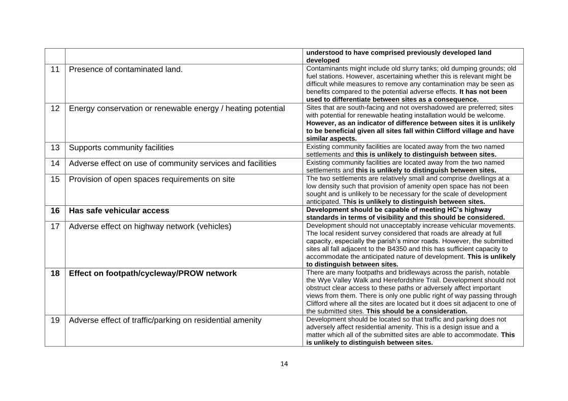
Appendix 4: Assessment Criteria
(Criteria used in the assessment highlighted in bold)
Ref Criteria Notes
1 Effect on environment designations (SSSI, Scheduled Ancient Monuments), Listed Buildings
Any sites which adversely directly affect this criterion will not be considered for development. However, no submitted sites are in such locations. Some do, however fall within the settings of heritage assets and their effects upon these need to be considered.
2 Within or adjacent to built-up areas within the parish, as designated by Herefordshire Council (Clifford Village and Priory Wood).
Development sites should be located in or adjacent to the two defined settlements. The rest of Clifford parish is classed as open countryside. All submitted sites fall within or adjacent to Clifford village and consequently this criterion will not differentiate between them..
3 Fits sensitively into setting and character of settlement. Developments should be no more than two storeys; density of development should reflect that of surrounding area; development should maintain the form and layout of the particular settlement, its setting within the landscape.
4 Effect on natural environment Sites should retain where possible natural features, benefit the ecological network and ensure the protection of important species. Some sites may require the removal of hedgerow and although this may not be a significant factor, especially as compensatory measures can be provided, it may prove useful in determine ng between sites.
5 Effect on landscape character/appearance/features The Parish’s two settlements fall within the Herefordshire Lowlands Natural Character Area2 where the emphasis is upon protecting and enhancing the natural and historic environment integrating new development through the use of green infrastructure principles informed by existing heritage, geodiversity and biodiversity assets. Priory Wood and the south of Clifford fall within the Principal Timbered Farmlands Landscape Type which typically has a dispersed development pattern without clusters of dwellings forming any settlements. The north side of Clifford falls within Principal Settled Farmlands Landscape Type that would normally have a pattern of small villages and hamlets only capable of accommodating limited new
2 file:///C:/Users/User/Downloads/HerefordshireLowlands%20(1).pdf

13
development. Filtered views through densely scattered hedgerow trees would be the norm although extensive views may also be prevalent from higher ground and along the Wye valley, with important receptors both within and outside of the Parish. The maintenance of landscape features is essential to settlement character and settings and this is considered a relevant criterion.
6 Adverse effect on amenity of nearby houses Gaps between houses should reflect that of surrounding houses. Protection of amenity and privacy covers matters such as significant intrusive overlooking of a main room or the most private area of the garden; insufficient space between buildings; unacceptable loss of appropriate levels of daylight to properties. This is most critical for small sites where development potential is normally considered through the defining of a settlement boundary than sites of a size sufficient for a housing allocation. Sites of a size to comprise a housing allocation would enable design and layout to address this issue and hence it is not considered such as to differentiate between site allocations.
7 Adverse effects of noise/air pollution on residential amenity of site from bad neighbour
There is an intensive livestock unit located close to Clifford village and anecdotal evidence that Herefordshire Council would wish to see a ‘cordon solitaire’ within which further housing development should not take place. This is considered a relevant criterion.
8 Sewage/sewerage problems. There is no mains sewerage in Clifford. Development sites should not interfere with or obstruct access to neighbouring soakaways. However, it is not possible to make such a judgement in relation to this while methods of treatment should be able to cope with any anticipated development given the nature of submitted sites. This is not considered a relevant criterion at this stage but would be reviewed in the light of evidence received through representations.
9 Likely risk of land drainage or flood Development should not take place on poorly drained sites. It should not cause run-off or other drainage problems for surrounding properties. No sites fall within flood risk zones 2 or 3. This is not considered a relevant criterion at this stage but would be reviewed in the light of evidence received through representations.
10 On green field site/brownfield. Agricultural land quality Use of brownfield sites is preferred. Where greenfield sites are necessary, those of lower agricultural value should be used first. This is considered relevant in that part of one of the sites is
14
understood to have comprised previously developed land developed
11 Presence of contaminated land. Contaminants might include old slurry tanks; old dumping grounds; old fuel stations. However, ascertaining whether this is relevant might be difficult while measures to remove any contamination may be seen as benefits compared to the potential adverse effects. It has not been used to differentiate between sites as a consequence.
12 Energy conservation or renewable energy / heating potential Sites that are south-facing and not overshadowed are preferred; sites with potential for renewable heating installation would be welcome. However, as an indicator of difference between sites it is unlikely to be beneficial given all sites fall within Clifford village and have similar aspects.
13 Supports community facilities Existing community facilities are located away from the two named settlements and this is unlikely to distinguish between sites.
14 Adverse effect on use of community services and facilities Existing community facilities are located away from the two named settlements and this is unlikely to distinguish between sites.
15 Provision of open spaces requirements on site The two settlements are relatively small and comprise dwellings at a low density such that provision of amenity open space has not been sought and is unlikely to be necessary for the scale of development anticipated. This is unlikely to distinguish between sites.
16 Has safe vehicular access Development should be capable of meeting HC’s highway standards in terms of visibility and this should be considered.
17 Adverse effect on highway network (vehicles) Development should not unacceptably increase vehicular movements. The local resident survey considered that roads are already at full capacity, especially the parish’s minor roads. However, the submitted sites all fall adjacent to the B4350 and this has sufficient capacity to accommodate the anticipated nature of development. This is unlikely to distinguish between sites.
18 Effect on footpath/cycleway/PROW network There are many footpaths and bridleways across the parish, notable the Wye Valley Walk and Herefordshire Trail. Development should not obstruct clear access to these paths or adversely affect important views from them. There is only one public right of way passing through Clifford where all the sites are located but it does sit adjacent to one of the submitted sites. This should be a consideration.
19 Adverse effect of traffic/parking on residential amenity Development should be located so that traffic and parking does not adversely affect residential amenity. This is a design issue and a matter which all of the submitted sites are able to accommodate. This is unlikely to distinguish between sites.

15
20 Provides affordable housing, preferably through community housing approach
The Parish has limited needs for affordable housing and an approach based upon community housing provision is considered one that would best address local needs. One of the sites appears to be of sufficient size to enable the level of development necessary to require an element of affordable housing although this would require the acceptance that a higher density should be accommodated than generally found in the village. In addition, development costs are expected to be high, involving removal of existing buildings and potentially clearing contamination. Nevertheless, this is considered a useful consideration even should it not prove possible to achieve.
21 Consistent with community’s aspirations for development on small sites.
The neighbourhood survey showed a preference for sites of three or fewer homes for any single housing development. This is a relevant consideration reflecting community concerns.
22 Maintains dark skies Sites should be located to minimise the effect of lighting on the environment. There should continue to be no street lighting in the settlements. Given the size and nature of sites submitted this is unlikely to distinguish between sites.

16
Appendix 5 : Housing Site Assessments

17
CLIFFORD NEIGHBOURHOOD PLAN
SITE ASSESSMENT JULY 2019
Site information Site Reference No. 1
Location/Address: At south west corner of junction of B4350 with Clifford Casle Lane (north)
Submitted By: Landowner
Site Area: 0.9 hectares (2.2 acres)
Estimated potential number of dwellings:
At a medium density 20 dwellings. At density reflecting that generally within the village – 8 to 12 dwellings.
Current Use: Mostly small paddock but small portion comprising frontage access to adjacent cottage
1. Protecting and Enhancing the Environment of the Villages 1. Development should minimise/avoid any impact on. National/international environmental designations
No such designations within the vicinity.
NB. Herefordshire Council’s HER (6155) identifies Whitehouse Farm to be an Historic Farmstead covered by its characterisation project. This may include that part of the site sitting along the road frontage. In such an instance, a heritage impact assessment might be required to inform the approach to development.
0
3. Fits sensitively into settlement
Development would not reflect the character of the settlement which on this side is predominantly cottages facing onto the B4350 without development in depth. Development would extend significantly along Clifford Castle Lane, changing its character. The extent of the change would be significant (major adverse).
- -
4. Effect on Natural Environment
Loss of hedgerow (minor adverse). The status of the grassland is unknown but not shown as a local wildlife site. An assessment would be useful to inform whether and what compensatory measures may be necessary.
-
5. Landscape character and appearance
Would not reflect the character indicated in HC’s LCA which indicates development should be limited (minor adverse).
-
18
2. Making the Best Use of Land and Resources, and Avoiding Pollution
7. Adverse pollution effects on residential amenity
Falls within 400m of intensive livestock unit although further away than some properties within the village (minor adverse).
-
10. Greenfield/Brownfield
Most of site is greenfield (minor adverse). -
3. Promoting Sustainable Transport 16. Safe vehicular access
Good visibility to left on exit from Clifford Castle Lane onto B4350 dependant on third party landowner keeping hedgerow well maintained. Alternative access could be provided directly onto B4350 from frontage along that road. Level of traffic exiting onto road may be relevant. Unlikely to result in site being considered unacceptable to some form of development.
0
18. Effect on Public Rights of Way
No adverse effect on any PROW. No direct connection to PROW or footpath.
0
4. Meeting Local Housing Needs 20. Provides for affordable housing
The site is of a size that ought to accommodate 11 or more dwellings and thereby providing an element of affordable housing. A policy requirement that was sustainable in this location would be required to achieve the appropriate level of development.
+
21. Preference for small sites
Development of a site of this size would not meet the community’s expressed preference.
-
Conclusion Of the four sites considered, this is the least satisfactory in terms of retaining Clifford’s character while offering limited benefits. The benefit would be in terms of enabling some affordable housing, but the site is of a size where, given the overall density within the village and the need for appropriate infrastructure, it might be argued that 10 or less dwellings would be appropriate. Consequently, there is insufficient certainty that the benefit might be delivered. In any event, the environmental effects should outweigh the potential benefit. The front of the site may, however, be included within a newly defined settlement boundary, given it is a reasonably small gap that sits between dwellings on the road frontage. This would provide an infill opportunity but would not normally form the basis for a housing allocation.

19
CLIFFORD NEIGHBOURHOOD PLAN
SITE ASSESSMENT JULY 2019
Site information Site Reference No. 2
Location/Address: Land south of White House
Submitted By: Landowner
Site Area: 0.2 hectares (0.5 acres)
Estimated potential number of
dwellings:
4 – 6. However, there is currently an outline
planning application for 2 dwellings upon the
site, although its potential is greater.
Current Use: Part of small paddock
1. Protecting and Enhancing the Environment of the Villages 1. Development should minimise/avoid any impact on. National/international environmental designations
No designated assets directly affected in this location.
NB. Herefordshire Council’s HER (231244) identifies land in this vicinity to be medieval ridge and furrow. This may include that part of the site although some development has already taken place in this vicinity. In such an instance, a heritage impact assessment might be required to inform the approach to development.
0
3. Fits sensitively into settlement
Development would not reflect the character of the settlement which on this side is predominantly cottages facing onto the B4350 without development in depth. The current arrangement, however, does suggest development may be expected in the layout and form of the access road and rear access to properties on the frontage. Good landscaping should minimise the effect of development in this location to
-

20
some extent minimising the effect on village character such that the extent of the change would be minor adverse.
4. Effect on Natural Environment
Development should not result in the loss of any hedgerow. The status of the grassland is unknown but not shown as a local wildlife site. An assessment would be useful to inform whether and what compensatory measures may be necessary.
0
5. Landscape character and appearance
Would not reflect the character indicated in HC’s LCA which indicates development should be limited (minor adverse)
-
2. Making the Best Use of Land and Resources, and Avoiding Pollution
7. Adverse pollution
effects on residential
amenity
Falls within 400m of intensive livestock unit although further away than some properties within the village (minor adverse).
-
10.
Greenfield/Brownfield
Site is greenfield (minor adverse). -
3. Promoting Sustainable Transport 16. Safe vehicular access
Access to a suitable standard already available (minor positive).
+
18. Effect on Public Rights of Way
No adverse effect on any PROW. No direct connection to PROW or footpath.
0
4. Meeting Local Housing Needs
20. Provides for affordable housing
Not of a size as to require an element of affordable housing.
-
21. Preference for small sites
Not a small site within the context set by the community.
-
Conclusion The site has some minor environmental effects although is immediately adjacent to an area that has recently seen some change. There are no major concerns that suggest development should be resisted.

21
CLIFFORD NEIGHBOURHOOD PLAN
SITE ASSESSMENT JULY 2019
Site information Site Reference No. 3
Location/Address: Land and buildings adjacent to Lower Court Farm
Submitted By: Landowner
Site Area: 1.2 hectares (3 acres) Estimated potential number of dwellings:
At a medium density 30 dwellings. At density reflecting that generally within the village and taking into account the adjacent Listed Building –around 10 - 12 dwellings. Landowner suggests 6.
Current Use: Comprises a mixture of agricultural buildings although the rear of the site has most recently been used as a timber yard.
1. Protecting and Enhancing the Environment of the Villages
1. Development should minimise/avoid any impact on. National/international environmental designations
Lower Court is a Grade 2* Listed Building and a barn to its north-east and a barn to its north are both Grade 2 Listed Buildings. These all lie immediately to the south-west of this site and within their settings. The site accommodates large and relatively modern agricultural buildings and a timber yard. These do not compliment the settings of the Listed Buildings. Some form of redevelopment should be possible that would enhance the settings of the important buildings. However, any proposal should be informed by a full and detailed Heritage Impact Assessment. On this basis it is suggested that development should have a positive effect on the heritage assets if undertaken in accordance with the conclusions of such an
+
22
assessment. There are no natural environment designations affecting this site.
3. Fits sensitively into settlement
The form of development in this location does extend back from the road frontage. Currently the site accommodates large agricultural buildings and an appropriately designed scheme with good landscaping, maintaining the current screening around the site, should be capable of fitting more sensitively into the settlement than the current form. It should also improve the views from the south-east as you emerge from Ton Wood and along the public right of way that runs from this wood towards the village.
+
4. Effect on Natural Environment
The site is already developed although its buildings should be inspected and if necessary surveys undertaken to determine whether there are any protected or important species present that would need measures to be utilised to accommodate or otherwise address their protection. There is a suggestion that a pond may be upon or near the site and this might require study. However, it should be possible to mitigate or compensate for any effects if such species are found. The site is of such a size and configuration that existing natural vegetation of any note on site should be capable of retention.
0
5. Landscape character and appearance
The site is currently well screened and this aspect in terms of effect on the wider landscape would be minor if any, notwithstanding its current uses. In terms specifically of landscape character development would not reflect the character indicated in HC’s LCA which indicates development should be limited (minor adverse). A survey of trees upon the site is considered necessary to determine which should be retained.
-
2. Making the Best Use of Land and Resources, and Avoiding Pollution
7. Adverse pollution effects on residential amenity
Falls within 400m of intensive livestock unit although further away than some properties within the village (minor adverse).
-
10. Greenfield/Brownfield
Although farm buildings are not technically ‘brownfield’ sites, the site is not a greenfield one. Part of the site is/has been used as a timber yard. Overall redevelopment is considered a positive in relation to this criterion.
+
3. Promoting Sustainable Transport 16. Safe vehicular access
It is possible to achieve appropriate visibility in both directions.
0
18. Effect on Public Rights of Way
There will be no adverse effects upon any public right of way. The site connects directly onto the village footpath whose southern end starts at the site.
+
4. Meeting Local Housing Needs

23
20. Provides for affordable housing
In theory the site is of a size that should be able to accommodate enough dwellings to require an element of affordable housing. However, this may affect the ability to deliver a scheme in view of higher than usual development costs arising from removing the existing buildings, addressing any contamination from the agricultural uses. In addition, the need to undertake a detailed heritage impact assessment and deliver a scheme that does not adversely affect the setting of adjacent Listed Buildings is likely to constrain the level of development. On balance it is considered that the site’s development is unlikely to deliver any affordable dwellings.
-
21. Preference for small sites
Development of a site of this size would not meet the community’s expressed preference.
-
Conclusion There are potential environmental benefits from developing this site provided its form and design is informed by a heritage impact assessment and high-quality landscaping. It is believed not to be within the scope of the community’s resources to undertake such an assessment in advance while it presents a reasonable opportunity to deliver a scheme that is expected to benefit the environment of the village and the nearby heritage assets.

24
CLIFFORD NEIGHBOURHOOD PLAN SITE ASSESSMENT JULY 2019
Site information Site Reference No. 4
Location/Address: Land north west of Cedar Bungalow
Submitted By: Landowner
Site Area: Appx. 0.25 hectares (0.6 acres)
Estimated potential number of dwellings:
2 - 3 dwellings
Current Use: Small paddock that appears to have been used for access and outside screened storage
1. Protecting and Enhancing the Environment of the Villages 1. Development should minimise/avoid any impact on. National/international environmental designations
No such designations within the vicinity. The site is separated from a group of Listed Buildings to the south by a further group of substantial and modern farm buildings. It is not considered that the settings of those Listed Buildings would be affected by development of this site.
NB. Herefordshire Council’s HER (19728) identifies a historic site of tenement plots SW of street, comprising a house (14th Century); and tenement (14th Century). In such an instance, a heritage impact assessment might be required to inform the approach to development.
0
3. Fits sensitively into settlement
Development would be expected to reflect the character of the settlement along the B4350 in that the site is upon its frontage and does not extend significantly away from the road. In any event, the site sits between the road and a bungalow that already sits
0

25
further away to the south-east. Its current use appears to be in association with the adjacent farm buildings (south) with an access through it to them and indications that it is used for external storage. The site is therefore surrounded by development on all its sides. As a consequence, it sits within the settlement and its development should not affect its setting or character to any significant degree.
4. Effect on Natural Environment
The site is confined within mature tree planting that is heavy along the road frontage. Some of this may need to be lost in order to accommodate development but sufficient exists that might be retained to make the effect minor adverse. Its use appears such as to indicate little of any biodiversity value within the open central area.
-
5. Landscape character and appearance
The site is currently well screened and this aspect in terms of effect on the wider landscape would be minor if any. Albeit that the surrounding development may conflict with the landscape character that would be expected in HC’s LCA, small scale development along the road frontage which this opportunity provides would not. A survey of trees upon the site is considered necessary to determine which should be retained.
-
2. Making the Best Use of Land and Resources, and Avoiding Pollution
7. Adverse pollution effects on residential amenity
Falls within 400m of intensive livestock unit although further away than some properties within the village (minor adverse). Of greater importance, however, is that development upon this site might suffer from the pollution effects of the adjacent agricultural buildings, should they be brought back into that use, and the timber yard. The potential effects would be from noise and air pollution. However, it has been indicated that the adjacent site might also be developed. In order to afford an appropriate standard of residential amenity to this site, it should come forward for development in association with the adjacent land.
-
10. Greenfield/Brownfield
Although not technically a ‘brownfield’ site, the site is not a greenfield one. Part of the site is/has been used for storage. Overall redevelopment is considered a positive in relation to this criterion.
+
3. Promoting Sustainable Transport 16. Safe vehicular access
It is possible to achieve appropriate visibility in both directions from the current point of access (it is assumed that there is a right of access across this frontage at that point as the visual inspection suggests) although this would require hedgerows along the frontage to be cut back and well maintained.
0
18. Effect on Public Rights of Way
A public right of way is indicated along the north side of the site but outside of the joint access and driveway
+
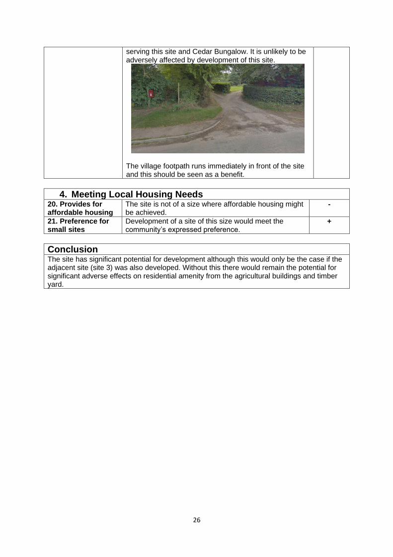
26
serving this site and Cedar Bungalow. It is unlikely to be adversely affected by development of this site.
The village footpath runs immediately in front of the site and this should be seen as a benefit.
4. Meeting Local Housing Needs 20. Provides for affordable housing
The site is not of a size where affordable housing might be achieved.
-
21. Preference for small sites
Development of a site of this size would meet the community’s expressed preference.
+
Conclusion The site has significant potential for development although this would only be the case if the adjacent site (site 3) was also developed. Without this there would remain the potential for significant adverse effects on residential amenity from the agricultural buildings and timber yard.

27
Appendix 5: Summary of Site ’Suitability’ Analysis
Site/ Criterion
1 3 4 5 7 10 16 18 20 21 Ranking
Site 1 0 -- - - - - 0 0 + - 4
Site 2 0 - 0 - - - + 0 - - 3
Site 3 + + 0 - - + 0 + - - 1
Site 4 0 0 - - - + 0 + - + 2

28
APPENDIX 6: PLANNING PERMISSIONS SINCE 2000 – CLIFFORD PARISH
APPLICATION NO LOCATION DWGs APPROVAL DATE
INSIDE (I)
OUTSIDE (O) SB
COMMENTS
P191248/F Land between Robin Cottage and Chestnut Cottage Clifford Hereford
HR3 5HG
1 6 August 2019 I Priory Wood
P190311/F Old Clifford Reservoir C1182 Clifford Clifford Herefordshire HR3 5HL
1 19 June 2019 O RBC (Rural Building Conversion)
P183987/F Old Pontfaen Barns Old Pontfaen Clifford Herefordshire HR3 5EW
1 17 April 2019 O RBC Duplicates P142687/F (October
2014)
180354 Land at Ton Farm Clifford Herefordshire HR3 5HQ
1 16 April 2018 O Considered to form part of Priory Wood although away from the
settlement
P173967/O Land to the North of Wellfield Bungalow Clifford Herefordshire HR3
5ER
5 25 April 2018 I Adj. to Clifford
P172581/F Priory Wood Presbyterian Church Clifford Hereford Herefordshire HR3
5HE
1 6 September 2017
O Conversion to dwelling
P171600/F Land at Priory Wood Clifford Hay on Wye Herefordshire
1 10 July 2017 I Priory Wood
P170847/O
Land adjacent to The Garlands Priory Wood Clifford Herefordshire
1 30 June 2017 I Priory Wood
P163054/F Land adjacent to High House Priory Wood Clifford Herefordshire
3 4 January 2017 I Priory Wood
P161420/PA4 Land at Clifford Place Clifford Herefordshire
1 20 June 2016 O RBC
P160200/F Site adjacent to Oakdene Clifford 1 4 April 2016 I Clifford

29
Whitney on Wye Herefordshire
P153165/F Lower Wyeside Clifford Hereford Herefordshire HR3 5EU
1 11 December 2015
I Clifford
P142860/F Part OS 1330 The Garlands Priory Wood Clifford Herefordshire
1 20 October 2015
I Priory Wood
SW100302/RM Field adjacent to Meadow Croft Church Road Clifford Herefordshire
HR3 5EY
1 8 April 2010 O Agricultural dwelling (Reserved matters)
Outline DSW091641/O
SW092199/F Pen-y-Lan Hardwicke Herefordshire HR3 5TA
1 27 January 2010 O RBC
DS080162/F The Haven Hardwicke Hay-On-Wye, Hereford, Hereford HR3 5TA
1 10 March 2008 O RBC
DS074037/F Sydcombe Farm Dorstone Hereford, Herefordshire HR3 6BA
3 8 February 2008 O RBC
DS072781/F Westbrook Farm Hardwicke Dorstone, Herefordshire HR3 5SY
4 10 October 2007
O RBC
DS052481/RM Site Adjacent To Byefield Clifford Hereford, Herefordshire HR3 5ER
1 14 September 2005
I Outline DS043754/O
DS044091/F Barn Adjacent To The Parks Far Poolpardon Nr Cusop, Herefordshire
HR3 5HH
1 12 January 2006 O RBC
DS030610/F The Haven Hardwicke Hay-On-Wye, Herefordshire HR3 5TA
1 17 July 2003 O Change of Use of Hotel to dwelling hence may not count as
a net gain
DS030319/F Hardwicke Dairy Hardwicke Cottage Clifford, Hay-On-Wye, Hereford HR3
5ES
1 26 March 2003 O RBC
DS022023/F Clifford Church Hall Church Road Clifford, Hereford
1 8 November 2002
O RBC See also DS012197/F
DS000975/F Part Of O S Plot No 8453 Adjoi Middlewood Clifford, Herefordshire
1 27 September 2000
O Agricultural dwelling Outline for this one. DS990376/O

30
HR3 5SX
DS992875/F Timber Framed Barn Adjacent To Clifford Nr Hay On Wye,
Herefordshire
1 16 November 2000
O RBC
16 dwellings in rural area 2000-2011; 5 dwellings 2011-2019; 21 in total
Trend rate 1.05 dwellings per annum (2000 – 2019). However, 0.625 trend rate 2011 – 2019. The majority of dwellings within rural areas
resulted from rural building conversions and this will be a dwindling resource. Hence, the rate 2011-2019 is considered more likely and if it
continues would result in 12 dwellings. With 5 having been granted permission between 2011-2019, a further 7 dwellings might be expected
based on this trend.