Kimberley Technology Solutions Pty Ltd - EPA WA | EPA...
75
Kimberley Technology Solutions Pty Ltd Cockatoo Island Multi-User Supply Base Referral - Supporting Document June 2017
-
Upload
nguyenkhanh -
Category
Documents
-
view
215 -
download
0
Transcript of Kimberley Technology Solutions Pty Ltd - EPA WA | EPA...

Kimberley Technology Solutions Pty LtdCockatoo Island Multi-User Supply Base
Referral - Supporting Document
June 2017

GHD | Report for Kimberley Technology Solutions Pty Ltd - Cockatoo Island Multi-User Supply Base, 6135178 | i
Executive summaryKimberley Technology Solutions Pty Ltd is referring the Cockatoo Island Multi-User Supply Base(the Proposal) to the Environmental Protection Authority (EPA) under Section 38 of theEnvironmental Protection Act 1986. This supporting document has been prepared to provideadditional information to supplement the s38 Referral, and to assist the EPA to decide whetherto assess the Proposal.
The Proposal would establish a hi-tech / subsea focused supply base as part of a multi-usersupply chain cluster. Developments would comprise an upgraded airfield, a wharf and anaftermarket subsea workshop as well as other related support infrastructure.
Six Key Environmental Factors were identified for the Proposal and an assessment ofsignificance was undertaken for each factor:
Benthic communities and habitat
The Project will result in the direct loss of 0.54 ha of hard coral and algae, of which 0.3 hais very sparse hard coral. Species are represented in adjacent bays and in higher densitiesand coverage. Some colonisation by marine species will occur on the new sheet piling. Asthis bay has very little primary producer habitat compared to the adjacent bays, there isunlikely to be a significant impact to local biological diversity and ecological integrity.
Coastal processes
The new wharf will run parallel to the shoreline and will not significantly affect or interruptlongshore current movements or existing coastal processes.
Any residual impacts on sedimentation, geomorphology, current speeds and patterns willbe localised and restricted to the vicinity of the wharf.
Marine environmental quality
The Proposal does not involve dredging or any planned discharge, and is not expected tointerrupt longshore current movements or existing coastal processes.
Impacts will be largely confined to the construction phase and limited to the immediate areaof construction that is largely dominated by unvegetated sandy environs. Further, due tothe large tidal regime and seasonally high rainfall, fluxes in total suspended solids andturbidity are common.
There is not expected to be any significant risk to maintaining environmental values of thewater, sediment and biota through the construction or operational phases.
Marine habitat and fauna
Given the proposed mitigation measures, lack of known critical marine fauna habitat in theimpacted bay and comparably less benthic communities and habitats than adjacent bays,the Proposal activities are not expected to result in any significant losses of marine fauna.There is the potential for some fauna losses to occur during the reclamation process, butprogressive reclamation will allow marine fauna to relocate.
During reclamation and piling, there is likely to be behavioural avoidance of the area butnot direct physical trauma. Any impacts to behaviour will be limited to transient individualsnear to the activity, as the area is not significant for cetaceans or turtles. Migrating speciesthat pass through the area will be able to navigate around any point source disturbance.

GHD | Report for Kimberley Technology Solutions Pty Ltd - Cockatoo Island Multi-User Supply Base, 6135178 | ii
With adherence to the management controls proposed, potential impacts are consideredacceptable.
Terrestrial vegetation
The impacts to terrestrial vegetation are based on the loss of 34.23 ha of native vegetation.No Threatened species or communities have been recorded, or are likely to occur onCockatoo Island and clearing will remove less than 10% of the remaining area ofEucalyptus woodland present across the Island. Some plants of the Priority 1 species,Triodia sp. Hidden Island will potentially be cleared, but a significant number of plants ofthis species occur in areas that are outside the Proposal area.
Drainage will be designed to minimise the risk of impact to downslope vegetation duringconstruction and operations. Revegetation using cleared topsoil and vegetative materialwill replace some of the vegetation initially removed.
Terrestrial fauna
The Proposal will result the loss of 34.23 ha of habitat for fauna, including foraging habitatsuitable for some conservation significant species. Some of the habitat will be re-generatedthrough topsoil and vegetation replacement following construction.
Some direct loss of reptile and SRE fauna will occur because of vegetation clearing andground disturbance but this is unlikely to affect conservation significant species as most arenocturnal and arboreal and can move away from the disturbance area.
The availability of other suitable habitat on Cockatoo Island and on adjacent islands andthe mainland is likely to ensure the survival and continued presence of the conservationsignificant species recorded.
Potential operational impacts are unlikely to significantly affect fauna presence or diversity.
Actual and potential impacts to terrestrial and marine flora and fauna and their habitats are notconsidered to be significant, due to the amount of existing disturbed habitat and to other,existing factors such as the availability of significant areas of adjacent habitat of similar, orbetter, quality.
The development and implementation of Construction and Operations EnvironmentalManagement Plans will assist in minimising impacts.

GHD | Report for Kimberley Technology Solutions Pty Ltd - Cockatoo Island Multi-User Supply Base, 6135178 | iii
Table of contents1. Introduction.....................................................................................................................................1
1.1 Purpose of this Document ...................................................................................................1
1.2 Overview of the Proposal.....................................................................................................1
1.3 The Proponent .....................................................................................................................1
1.4 Location of the Proposal ......................................................................................................1
2. The Proposal ..................................................................................................................................3
2.1 Proposal Justification ...........................................................................................................3
2.2 On-shore Developments......................................................................................................3
2.1 Marine Developments ..........................................................................................................8
2.2 Staging...............................................................................................................................10
3. Stakeholder Consultation .............................................................................................................11
4. Environmental Principles and Factors .........................................................................................13
4.1 Principles ...........................................................................................................................13
4.2 Identification of Key Environmental Factors ......................................................................14
4.3 Key Environmental Factor - Benthic Communities and Habitat ........................................15
4.4 Key Environmental Factor - Coastal Processes ................................................................25
4.5 Key Environmental Factor - Marine Environmental Quality...............................................28
4.6 Key Environmental Factor - Marine Fauna........................................................................30
4.7 Key Environmental Factor - Flora and Vegetation.............................................................41
4.8 Key Environmental Factor - Terrestrial Fauna...................................................................50
5. Conclusions..................................................................................................................................57
5.1 Benthic communities and habitat.......................................................................................57
5.2 Coastal processes .............................................................................................................57
5.3 Marine environmental quality.............................................................................................57
5.4 Marine habitat and fauna ...................................................................................................57
5.5 Terrestrial vegetation .........................................................................................................58
5.6 Terrestrial fauna.................................................................................................................58
6. References...................................................................................................................................59
Table indexTable 4-1 Identification of Key Environmental Factors ......................................................................14
Table 4-2 Baseline studies – benthic communities and habitat.........................................................15
Table 4-3 Substrate percentages within each of the three bays........................................................17
Table 4-4 Marine habitat types within Bay 1 ......................................................................................17
Table 4-5 Marine habitat types within Bay 2 ......................................................................................19
Table 4-6 Marine habitat types within Bay 3 (Copper Bay) ...............................................................22

GHD | Report for Kimberley Technology Solutions Pty Ltd - Cockatoo Island Multi-User Supply Base, 6135178 | iv
Table 4-7 Baseline studies – coastal processes................................................................................25
Table 4-8 Local tidal planes ...............................................................................................................26
Table 4-9 Baseline studies – marine environmental quality ..............................................................28
Table 4-10 Baseline studies – marine fauna........................................................................................30
Table 4-11 Conservation significant marine mammals........................................................................31
Table 4-12 Conservation significant fish ..............................................................................................33
Table 4-13 Conservation significant marine reptiles ............................................................................35
Table 4-14 Baseline studies – flora and vegetation .............................................................................42
Table 4-15 Vegetation associations within the survey area.................................................................44
Table 4-16 Species recorded as range extensions and their current known range ............................46
Table 4-17 Clearing of local vegetation associations...........................................................................47
Table 4-18 Vegetation condition ..........................................................................................................47
Table 4-19 Vegetation association 8001 extent (Beard 1977, GoWA 2015).......................................48
Table 4-20 Baseline studies – terrestrial fauna....................................................................................50
Table 4-21 Conservation significant fauna known to occur on Cockatoo Island .................................53
Table 4-22 Invertebrate species recorded within the survey area .......................................................54
Figure indexFigure 1-1 Location map .......................................................................................................................2
Figure 2-1 Layout of proposal elements................................................................................................4
Figure 2-2 Three bay hangar with bi-fold door ......................................................................................5
Figure 2-3 Above-ground self-bunded Jet A1 tank 22,000 L ................................................................5
Figure 2-4 Disturbance areas................................................................................................................7
Figure 2-5 Schematic of proposed wharf ..............................................................................................8
Figure 2-6 Schematic of proposed subsea workshop...........................................................................9
Figure 4-1 Substrate type....................................................................................................................16
Figure 4-2 Benthic communities and habitats .....................................................................................18
Figure 4-3 Hard coral coverage...........................................................................................................20
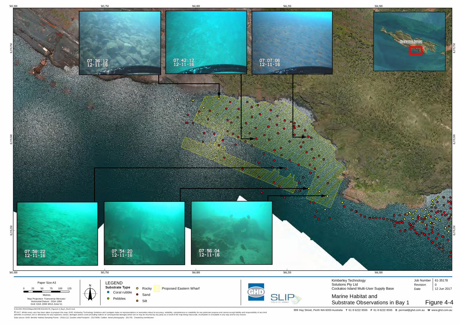
Figure 4-4 Marine habitat and substrate observations in Bay 1..........................................................21
Figure 4-5 Indicative bathymetry based on interpolation of data from C-MAP (JeppesenCharts). Levels referenced to Chart Datum.......................................................................26
Figure 4-6 Bay 1 site photograph........................................................................................................27
Figure 4-7 Vegetation associations and conservation significant flora locations................................43
Figure 4-8 Vegetation condition ..........................................................................................................45
Figure 4-9 Fauna habitats and conservation significant fauna locations ............................................51

GHD | Report for Kimberley Technology Solutions Pty Ltd - Cockatoo Island Multi-User Supply Base, 6135178 | v
AppendicesAppendix A – Technical Study - Marine Flora and Fauna
Appendix B – Technical Study - Terrestrial Flora and Fauna

GHD | Report for Kimberley Technology Solutions Pty Ltd - Cockatoo Island Multi-User Supply Base, 6135178 | vi
Abbreviations and Acronyms
Abbreviation Definition
AHD Australian Height Datum
CD Chart datum (approx. 0 mLAT)
DotEE Department of Environment and Energy
DPaW Department of Parks and Wildlife
DSEWPaC Department of Sustainability, Environment, Water, Population and Communities
EP Act Environment Protection Act 1986
EPA Environmental Protection Authority
EPBC Act Environment Protection and Biodiversity Conservation Act 1999
FAT Facility Acceptance Testing
ha Hectare
HPU Hydraulic Power System
IBRA Interim Biogeographic Region of Western Australia
IWOCS Intervention Workshop Control System
km Kilometre
KTS Kimberley Technology Solutions Pty Ltd
kV Kilovolt
L Litre
LAT Lowest Astronomical Tide
LCT Large Carrier Tank
LCTV Large Crew Transfer Vessel
LGA Local Government Area
m Metre
m3 Cubic metre
m/s Metres per second
MARPOL International Convention for the Prevention of Pollution from Ships
MCP Master Control Panel
mg/L Milligrams per litre
mg/kg Milligrams per kilogram
ML Million litres
PEC Priority Ecological Community
PSV Platform Supply Vessel
t Tonne
TEC Threatened Ecological Community
SMPEP Shipboard Marine Pollution Emergency Plan
SOPEP Shipboard Oil Pollution Emergency Plan

GHD | Report for Kimberley Technology Solutions Pty Ltd - Cockatoo Island Multi-User Supply Base, 6135178 | 1
1. Introduction1.1 Purpose of this Document
Kimberley Technology Solutions Pty Ltd (KTS) is referring the Cockatoo Island Multi-UserSupply Base (the Proposal) to the Environmental Protection Authority (EPA) under Section 38of the Environmental Protection Act 1986 (EP Act). This supporting document has beenprepared to provide additional information to supplement the s38 Referral, and to assist theEPA to decide whether to assess the Proposal.
1.2 Overview of the Proposal
KTS proposes to construct and operate the Proposal from Cockatoo Island.
The Proposal would establish a hi-tech / subsea focused supply base as part of a multi-usersupply chain cluster. Developments would comprise an upgraded airfield, a wharf and anaftermarket subsea workshop as well as other related support infrastructure.
The cluster incorporates the towns of Broome and Derby and is based on the Norwegian model,which focuses specific industries within an area but not necessarily in one location.
The Proposal would support the exploration, development and operation of oil and gas projectsin the Browse Basin. It will also increase opportunities for other strategic industries such asDefence and Tourism in north-western Australia and significantly reduce the operating costs ofthe mine on Cockatoo Island.
The Proposal represents an opportunity to use the Norwegian model as a test case in WesternAustralia which, when established, will draw business from existing locations in Asia andinterstate. It can be used by the State Government as a catalyst for bringing real economicdevelopment to the Kimberley region.
1.3 The Proponent
The Proponent for the Proposal is Kimberley Technology Solutions Pty Ltd, a joint venturebetween NorSea Group, Brunel Australia and Advantec Group and advised by Global Air andEnergy (Singapore). Contact details for the Proponent are:
Mr Jeremy BowerKimberley Technology Solutions Pty LtdLevel 2, 101 St Georges Terrace, Perth WA 6000Ph: 08 9429 5600ACN: 615 631 386
1.4 Location of the Proposal
Cockatoo Island is located approximately 7 km off the Western Australian coast within theBuccaneer Archipelago, approximately 130 km north of Derby (Figure 1-1). The Island islocated within Yampi Sound, between Irvine and Koolan Islands.
The Island has historically been mined for iron ore, with mining operations on the Islandcommencing in 1951. Mining operations on the Island are currently in care and maintenance.Existing infrastructure and disturbances on the Island include an airstrip, processing plant, openpit mine (involving mining of high grade ore from a deposit below sea level), a permanentseawall, wharf with ship loading facilities and historic township.

562,000
562,000
564,000
564,000
566,000
566,000
568,000
568,0008,218,
000
8,218,
000
8,220,
000
8,220,
000
8,222,
000
8,222,
000
G:\61\35178\GIS\Maps\MXD\EIA\6135178_Figure1-1_Location_Rev0.mxd© 2017. Whilst every care has been taken to prepare this map, GHD, Kimberley Technology Solutions Ltd, GA and Landgate make no representations or warranties about i ts accuracy, reliability, completeness or suitability for any particular purpose and cannot accept liability and responsibility of any kind (whether in contract, tort or otherwise) for any expenses, losses, damages and/or costs (including indirect or consequential damage) which are or may be incurred by any party as a result of the map being inaccurate, incomplete or unsuitable in any way and for any reason.
0 200 400 600 800 1,000
MetresMap Projection: Transverse Mercator
Horizontal Datum: GDA 1994Grid: GDA 1994 MGA Zone 51
Kimberley Technology Solutions Pty LtdCockatoo Island Multi-User Supply Base
Figure 1-1
Job NumberRevision 0
61-35178
14 Jun 2017
Location Map
Date
Data source: Calibre: Aerial photography - 201703; GA: Geoscience Australia Topo 250k Series III - 2006. Created by: mmikkonen
Paper Size A3
999 Hay Street, Perth WA 6000 Australia T 61 8 6222 8555 F 61 8 6222 8555 E [email protected] W www.ghd.com.au
Cockatoo IslandIndian Ocean
WA
BROOMEDERBY
KALUMBURU
FITZROYCROSSING
Locality Map

GHD | Report for Kimberley Technology Solutions Pty Ltd - Cockatoo Island Multi-User Supply Base, 6135178 | 3
2. The Proposal2.1 Proposal Justification
The Proposal will:
Increase safety advantage during the petroleum life cycle
Promote economic activity in the locations which make up the cluster with Cockatoo Island
Make best use of existing assets without substantial government funded capital upgrades,allowing for a staged development approach
Transfer technology and knowledge from proven international locations to enhanceAustralian local content
Support mining operations on Cockatoo Island by reducing logistics costs
Assist nearby mining operations through shared services and an expansion of serviceproviders within the key Kimberley towns
Centralise selected hi-tech services for Browse Basin oil and gas operators currentlyhaving to rely on subsea support from further afield (Asian ports and Darwin)
Link into the supply chain corridor between Perth and Singapore.
2.2 On-shore Developments
Onshore developments will primarily consist of an expanded and upgraded airstrip for fixedwing aircraft and helicopters, airfield support facilities, an accommodation village and site roads.
2.2.1 Airfield, laydown and roads
Airfield
The airfield footprint will be approximately 30 ha, comprising a 1,950 m long by 30 m widepaved airstrip, 90 m wide clearway and a taxiway of 400 m by 100 m (Figure 2-1). The airstripwill provide a take -off distance of 1800 m.
The design follows the alignment of the existing airstrip which reduces the disturbance footprint,makes use of existing mined waste material, uses locally mined rock and will make use of alocally based mining fleet and support system to reduce mobilisation/demobilisation.
Drainage from the airfield will be directed to table drains for infiltration.
Terminal and hangars
An aviation terminal will be constructed adjacent to the runway (Figure 2-1). The proposedstructure will be approximately 40 m x 20 m.
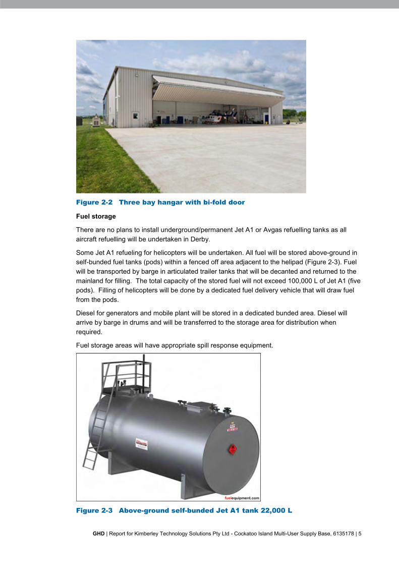
The helipad will be designed to accommodate a 3-bay hangar (Figure 2-2).

564,000
564,000
565,000
565,000
566,000
566,000
567,000
567,000
568,000
568,0008,219,
000
8,219,
000
8,220,
000
8,220,
000
8,221,
000
8,221,
000
G:\61\35178\GIS\Maps\MXD\EIA\6135178_Figure2-1_LayoutOfProposalElements_Rev0.mxd© 2017. Whilst every care has been taken to prepare this map, GHD, Kimberley Technology Solutions, Cardno and Landgate make no representations or warranties about its accuracy, reliabili ty, completeness or suitability for any particular purpose and cannot accept l iability and responsibi lity of any kind (whether in contract, tort or otherwise) for any expenses, losses, damages and/or costs (including indirect or consequential damage) which are or may be incurred by any party as a result of the map being inaccurate, incomplete or unsuitable in any way and for any reason.
0 100 200 300 400 500
MetresMap Projection: Transverse Mercator
Horizontal Datum: GDA 1994Grid: GDA 1994 MGA Zone 51
Kimberley Technology Solutions Pty LtdCockatoo Island Multi-User Supply Base
Figure 2-1
Job NumberRevision 0
61-35178
12 Jun 2017
Layout of Proposal Elements
Date
Data source: Cardno: Clearing elements - 20170606; Calibre: Aerial photography - 201703. Created by: mmikkonen
Paper Size A3
999 Hay Street, Perth WA 6000 Australia T 61 8 6222 8555 F 61 8 6222 8555 E [email protected] W www.ghd.com.au
LEGENDProposed AirstripProposed Laydown AreaProposed Eastern Wharf
Proposed Road
Terminal
Helicopter stand
Laydown 1
Laydown 2
Laydown 3
Hangar
GHD | Report for Kimberley Technology Solutions Pty Ltd - Cockatoo Island Multi-User Supply Base, 6135178 | 5
Figure 2-2 Three bay hangar with bi-fold door
Fuel storage
There are no plans to install underground/permanent Jet A1 or Avgas refuelling tanks as allaircraft refuelling will be undertaken in Derby.
Some Jet A1 refueling for helicopters will be undertaken. All fuel will be stored above-ground inself-bunded fuel tanks (pods) within a fenced off area adjacent to the helipad (Figure 2-3). Fuelwill be transported by barge in articulated trailer tanks that will be decanted and returned to themainland for filling. The total capacity of the stored fuel will not exceed 100,000 L of Jet A1 (fivepods). Filling of helicopters will be done by a dedicated fuel delivery vehicle that will draw fuelfrom the pods.
Diesel for generators and mobile plant will be stored in a dedicated bunded area. Diesel willarrive by barge in drums and will be transferred to the storage area for distribution whenrequired.
Fuel storage areas will have appropriate spill response equipment.
Figure 2-3 Above-ground self-bunded Jet A1 tank 22,000 L

GHD | Report for Kimberley Technology Solutions Pty Ltd - Cockatoo Island Multi-User Supply Base, 6135178 | 6
Utilities
The proposed location of the apron and terminal are close to the existing Island bores. Thissupply will service the ablution facilities and will be filtered to provide potable water.
Sewage will be treated in a contained septic tank system.
Power will be provided to the terminal by a dedicated 150 kV diesel genset with backup. In theevent that the airfield’s clients request the provision of runway lighting, this will be provided by a500 kV genset with backup. These will be switched off when the terminal is not in use.
Laydown and roads
Some land adjacent to the airfield and the wharf (Figure 2-1) will be used for:
Laydown (overflow from the wharf) of pipe, umbilical reels, containers of spares and parts,drilling equipment and bulk materials
Construction support
Offices
Workshop and warehousing.
Construction support will comprise a demountable site office and less than 20 accommodationunits. These will be relocated or dismantled when not required. It is intended to make use of thepermanent accommodation on the existing Crown Lease for staff and occasional visitors.
Additional offices, warehouses and workshops will be developed in the future if demandexceeds available space at the wharf.
A road will link the airfield to the wharf (Figure 2-1). This makes use of an existing haul road tothe mining tenement. A short extension, not shown on the figure, will be required to connect thishaul road to the wharf.
Accommodation may be required should there be space constraints on the existing CrownLease. This will be the subject of a separate application.
2.2.2 Construction
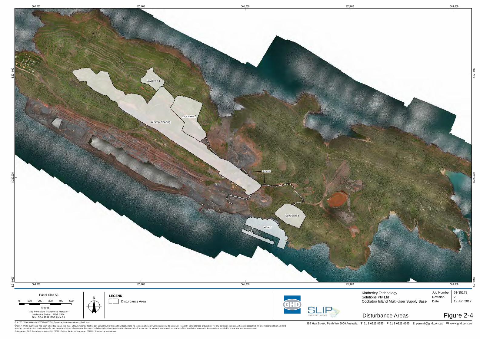
Construction will disturb up to approximately 53 ha of land (Figure 2-4).
Clearing for the airfield and laydown areas will be undertaken by bulldozer. Cleared vegetationwill be respread on areas being rehabilitated including those associated with the mine.
The geology of the area to be levelled indicates that bands of hard rock are present. Provisionhas been made for up to 80% drill and blast. Loose rock will be moved by truck to areasrequiring fill.
The airfield will be bituminised and a temporary bitumen plant will be mobilised. Aggregate willbe sourced from the borrow pits on the mining lease and will be crushed and screened on-site.
Construction materials for buildings will be barged to the Island, offloaded and erected on-site.
Extending the existing haul road to the wharf will require some limited blasting. Material will beused in reclamation for the wharf.
Putrescible wastes will be disposed at the existing licenced landfill on the Island. There is alsoan existing metal dump for disposal of metal waste. Waste hydrocarbons will be removed fromthe Island for reprocessing. Wastes that cannot be disposed onsite will be transferred to themainland by barge for disposal.
564,000
564,000
565,000
565,000
566,000
566,000
567,000
567,000
568,000
568,0008,219,
000
8,219,
000
8,220,
000
8,220,
000
8,221,
000
8,221,
000
G:\61\35178\GIS\Maps\MXD\EIA\6135178_Figure2-4_DisturbanceAreas_Rev2.mxd© 2017. Whilst every care has been taken to prepare this map, GHD, Kimberley Technology Solutions, Cardno and Landgate make no representations or warranties about its accuracy, reliabili ty, completeness or suitability for any particular purpose and cannot accept l iability and responsibi lity of any kind (whether in contract, tort or otherwise) for any expenses, losses, damages and/or costs (including indirect or consequential damage) which are or may be incurred by any party as a result of the map being inaccurate, incomplete or unsuitable in any way and for any reason.
0 100 200 300 400 500
MetresMap Projection: Transverse Mercator
Horizontal Datum: GDA 1994Grid: GDA 1994 MGA Zone 51
Kimberley Technology Solutions Pty LtdCockatoo Island Multi-User Supply Base
Figure 2-4
Job NumberRevision 2
61-35178
12 Jun 2017
Disturbance Areas
Date
Data source: GHD: Disturbance areas - 20170606; Calibre: Aerial photography - 201703. Created by: mmikkonen
Paper Size A3
999 Hay Street, Perth WA 6000 Australia T 61 8 6222 8555 F 61 8 6222 8555 E [email protected] W www.ghd.com.au
LEGENDDisturbance Area
Airstrip clearing
Wharf
Laydown 1
Laydown 2
Laydown 3
Roads

GHD | Report for Kimberley Technology Solutions Pty Ltd - Cockatoo Island Multi-User Supply Base, 6135178 | 8
2.2.3 Operations
With a single client, air traffic will consist of two Regional Jets and eight to ten helicopter cycles(take-off and landing) per week. Fixed wing aircraft will only operate during daylight hours withhelicopters operating both day and night.
Waste materials during operations will be disposed in a similar manner to construction wastes.
2.1 Marine Developments
The bay to the east of the existing ship loader has a suitable profile for development of a wharf.The bay comprises a sandy beach at low tide with a drop off to between -10 mCD and- 20 mCD.
2.1.1 Wharf and subsea workshop
Wharf
The topography of the seabed together with the tides experienced at Cockatoo Island favour thedevelopment of an anchored sheet pile retaining wall inside the drop off and a floating outerquayside caisson attached to the shore by a linkspan (Figure 2-5). This design allows foraccess at all stages of the tide, reduces the footprint on the seabed and reduces cost ofconstruction.
Figure 2-5 Schematic of proposed wharf
The eastern end of the wharf will accommodate a fixed section to access the deeper waterclose to shore and is the preferred location for the subsea workshop.
The access road to the wharf is shown in Figure 2-1.
The proposed facilities on the wharf are:
Tanks – 1 ML of marine gas oil in self-bunded tanks and 0.5 ML of potable and/or drillingwater. Final location will be subject to detailed design
Warehouse – 100 m x 40 m. Steel and colour bond construction. Cyclone rated
Diesel and hydraulic fluids in drums within bunded and covered areas

GHD | Report for Kimberley Technology Solutions Pty Ltd - Cockatoo Island Multi-User Supply Base, 6135178 | 9
Laydown areas – demarcated on the wharf for pipe, umbilical reels, containers of sparesand parts, drilling equipment and bulk materials
Lighting to allow for night works
Mobile Cranes – 250 t
2 x 500 kV generators, 1 operating and one on standby
Contained grey and blackwater treatment plant
Future LNG bunkering
30 m x 20 m Large Crew Transfer Vessel (LCTV) passenger terminal.
Subsea workshop
The workshop will provide subsea aftermarket support such as:
Receiving subsea components (trees)
Systems Integration Testing (SIT)
Factory Acceptance Testing (FAT)
Control System servicing and testing and repair
Storage of control modules such as Intervention Workover Control Systems (IWOCS),Master Control Panels (MCP) and Hydraulic Power Systems (HPU)
Storage of tools and parts.
The workshop will be 96 m x 50 m, of steel and colour bond construction, and cyclone rated(Figure 2-6).
Figure 2-6 Schematic of proposed subsea workshop
The workshop will be integrated with a gantry crane that can access the quayside. Theworkshop portion will contain a test pit that can be flooded and discharged. The test pit willservice equipment designed to operate on the seabed so there is minimal risk of watercontamination within the pit and the discharge water. The test pit is isolated from thesurrounding seawater.
Power will be supplied by 2 x 500 kV gensets, one active and one on standby.

GHD | Report for Kimberley Technology Solutions Pty Ltd - Cockatoo Island Multi-User Supply Base, 6135178 | 10
Sewage will be collected in tanks and transferred to the septic tank system at the airstrip fordisposal.
2.1.2 Construction
Whilst geotechnical drilling has not been undertaken at the proposed site, the geology of theadjacent bay is well described. The geology suggests that the piles will encounter the QuarrySchist and will not penetrate any coralline sediments.
The depth of bedrock below the seabed is estimated at 5 m – 15 m. The sheet piling will beanchored into the bedrock by drilling a toe in the rock to a depth of 1 m to stabilise the foot andthe pilings will be stabilised with tiebacks to anchors.
The quayside caissons will be anchored by a series of concrete and steel pilings that will beanchored into the bedrock.
The caisson and subsea area pilings will require rock drilling and cementing.
The wharf area behind the sheet pile will be around 6.2 ha and will require around 75,600 m3 offill to raise the level of the platform to 2 m above high tide. Fill will be sourced from benign minewaste, compacted and sealed with a concrete, layblock or asphalt hardstand. Waste rock will bedelivered using the mine’s current vehicle fleet and progressively tipped into the reclamationarea, starting from the shoreline.
No dredging will be required.
Putrescible wastes will be disposed at the existing licenced landfill on the Island. There is alsoan existing metal dump for disposal of metal waste. Waste hydrocarbons will be removed fromthe Island for reprocessing. Wastes that cannot be disposed onsite will be transferred to themainland by barge for disposal.
2.1.3 Operations
Activity at the wharf will be dependent on drilling and construction campaigns and traffic willvary as a result. The wharf will typically handle two LCTV port calls per day, two subsea vesselcalls per month averaging five days, four to five Platform Supply Vessel (PSV) calls per week,two Large Carrier Tank (LCT) calls per week and one to two other industry calls per month(defence and tourism).
Operations will occur 24/7 as required.
Waste materials during operations will be disposed in a similar manner to construction wastes.
2.2 Staging
The preceding discussion identifies the ultimate development for the Proposal.
However, to take into account activities associated with Prelude and Ichthys hook-up,commissioning and production stages, as well as construction and production for Browse, thereis flexibility to progressively develop the Proposal.
Staging could include:
Initially bitumising the existing airstrip and upgrading the existing terminal building with theaddition of another transportable unit to allow for new seating
Progressive development of the airstrip to 1600 m, 1800 m and ultimately 1950 m
Construction of the new terminal based on passenger demand
Construction of the helipad based on demand.

GHD | Report for Kimberley Technology Solutions Pty Ltd - Cockatoo Island Multi-User Supply Base, 6135178 | 11
3. Stakeholder ConsultationKTS has completed an extensive stakeholder engagement program outlining the Proposal tothe following government departments and stakeholder groups:
Department of State Development
Department of Mines and Petroleum
Department of Lands
Department of Premier and Cabinet
Department of Transport
Kimberley Ports Authority
Shire of Derby/West Kimberley
Office of the Environmental Protection Authority
Dambimangari Aboriginal Corporation (Dambimangari)
Djarindjin Aboriginal Corporation
Lombadina Aboriginal Corporation
Ardyloon/One Arm Point Aboriginal Corporation
Pelican Resources Limited
Pluton Resources Limited.
There is engagement and ongoing dialogue with Pelican Resources Limited, Pluton ResourcesLimited (mining lease holders on Cockatoo Island) and the Traditional Owners and Native Titleholders of Cockatoo Island, the Dambimangari.
KTS will undertake ethnographic and anthropologic heritage studies with the cooperation of theIslands Traditional Owners. KTS and Dambimangari have agreed to a Heritage Protocol foractivates undertaken on the Island and are negotiating a Land Access Agreement.
Department of Parks and Wildlife
Following the completion of the 2016 baseline biological survey (GHD 2017), GHD arranged ateleconference with staff from Department of Parks and Wildlife (DPaW) West Kimberley Districtto discuss the Proposal and expectations in relation to survey effort and guidance onassessment of impacts to conservation significant flora and fauna species. In particular, GHDsought advice on the implications of the extensive 2016 bushfire on Cockatoo Island on furthertargeted surveys of the Triodia sp. Hidden Island, as well as survey effort to date targeting bats(including the Environment Protection and Biodiversity Conservation Act 1999 (EPBC Act) listedGhost Bat).
Participants in the teleconference included:
Bruce Greatwich (DPaW – West Kimberley District)
Karen Bettick (DPaW – West Kimberley District)
Glen Gaikhorst (Principal Zoologist, GHD)
Jordan Tindiglia (Senior Environmental Scientist, GHD)
Jeremy Bower (on behalf of KTS).

GHD | Report for Kimberley Technology Solutions Pty Ltd - Cockatoo Island Multi-User Supply Base, 6135178 | 12
During the teleconference, the following key points were discussed:
GHD explained that Triodia sp. Hidden Island had previously been collected from onelocation in the central part of the Island during the 2014 wet season survey (GHD 2014).The plant was located adjacent to a track, north of the airpstrip in an area that hadhistorically been used as a material dump (believed to be back in the 1950s). GHDrevisited the location during the 2016 field survey, however, the site had been burnt andthe Triodia could not be re-located. Staff from DPaW advised that further assessmentshould be based on the existing/baseline habitats present, not just the post-fire habitats i.e.although the vegetation has been burnt, the habitat is still present on the Island. DPaWalso advised that the fire should be considered as a limitation to the December 2016survey. There was agreement between GHD and DPaW that further targeted survey workwould be undertaken to determine the extent of the species’ distribution elsewhere on theIsland.
GHD outlined the previous survey effort undertaken for Threatened and Priority batspecies, the species recorded and the habitats available for bats on the Island. Previoussurveys have identified the presence of three species on the Island, including the GhostBat, Northern Leaf-nosed Bat and Little North-western Mastiff Bat. There was a generaldiscussion of the foraging/hunting and breeding habitat for each of these species and Glenexplained there is one cave potentially suitable to support the roosting (of Ghost Bat andNorthern Leaf-nosed Bat) in close proximity to the disturbance footprint. It is unknown howthis cave is affected by the tidal movements (i.e. partially or completely fills with water)and/or is utilised by any bat species. DPaW advised that as the cave is outside theproposed disturbance footprint, the main concern would be noise and vibration impactsassociated with blasting activities during construction. DPaW indicated that no furthersurvey effort would be needed to assess the suitability of the cave as bat roosting habitat.DPaW also raised the issue of increased aircraft flights at night and the associatedincreased risk of striking bats. Jeremy advised that there are no anticipated schedulednight flights, except in the case of an emergency.
The northern sub-species of the Masked Owl was also discussed, including the previousrecord of the species on the Island and the impact of the 2016 fire on the value of thewoodland habitat for breeding. Glen described the lack of trees with hollows that mayprovide breeding and roosting opportunities for the species and how little impact is likely onthe species. DPaW indicated that the habitat should be assessed as if it was pre-fire, andpotential impacts evaluated accordingly.
The outcomes of this discussion indicated that no further survey effort would be required for theGhost Bat and northern sub-species of the Masked Owl, however a targeted flora survey shouldbe undertaken to determine the distribution of Triodia sp. Hidden Island. This has beencompleted and the results are presented in GHD (2017) and discussed in this report.

GHD | Report for Kimberley Technology Solutions Pty Ltd - Cockatoo Island Multi-User Supply Base, 6135178 | 13
4. Environmental Principles and Factors4.1 Principles
Section 4A of the EP Act establishes the object and principles of the Act. In accordance with theEPA’s Statement of Environmental Principles, Factors and Objectives (EPA 2016), this sectiondescribes how each of the five principles of the EP Act has been applied to the Proposal.
Principle Consideration of Principle in the Proposal
The precautionary principleWhere there are threats of serious or irreversibledamage, lack of full scientific certainty should not beused as a reason for postponing measures to preventenvironmental degradation.In the application of the precautionary principle,decision should be guided by:a. careful evaluation to avoid, where practicable,serious or irreversible damage to the environment; andb. an assessment of the risk-weighted consequencesof various options.
Baseline and targeted flora and fauna surveys havebeen undertaken for the entire area potentiallyimpacted by the Proposal. Information collectedbuilds on information from earlier surveys.No significant impacts are likely from constructionand operation of the Proposal.The Proposal will have a relatively smalldisturbance footprint with a significant proportion ofthe development occurring on previously disturbedareas.
The principle of intergenerational equityThe present generation should ensure that the health,diversity and productivity of the environment ismaintained or enhanced for the benefit of futuregenerations.
No significant impact to the existing environment ispredicted to occur.
The principle of the conservation of biologicaldiversity and ecological integrityConservation of biological diversity and ecologicalintegrity should be a fundamental consideration.
The Proposal will not threaten biological diversity orecological integrity.
Principles relating to the improved valuation,pricing and incentive mechanismsa. Environmental factors should be included in thevaluation of assets and services.b. The polluter pays principle – those who generatepollution and waste should bear the cost ofcontainment, avoidance or abatement.c. The users of goods and services should pay pricesbased on the full life cycle costs of providing goods andservices, including the use of natural resources andassets and the ultimate disposal of any wastes.d. Environmental goals, having been established,should be pursued in the most cost effective way, byestablishing incentive structures, including marketmechanisms, which enable those best placed tomaximise benefits and/or minimise costs to developtheir own solutions and responses to environmentalproblems.
The Proposal is not expected to generate anysignificant pollution or waste.Justification for the Proposal includes incentives toreduce environmental footprints and costs including: Promote economic activity in the locations
which make up the cluster with CockatooIsland
Make best use of existing assets withoutsubstantial government funded capitalupgrades
Assist nearby mining operations throughshared services and an expansion of serviceproviders within the key Kimberley towns
Centralise selected hi-tech services forBrowse Basin oil and gas operators currentlyhaving to rely on subsea support from Asianports and Darwin.
The principle of waste minimisationAll reasonable and practicable measures should betaken to minimise the generation of waste and itsdischarge into the environment.
Construction and operation of the facility will notresult in the generation of significant waste streams.Putrescible wastes will be disposed at the existinglicenced landfill on the Island. There is also anexisting metal dump for disposal of metal waste.Waste hydrocarbons will be removed from theIsland for reprocessing. Wastes that cannot bedisposed onsite will be transferred to the mainlandby barge for disposal.Cut and fill volumes for the airstrip essentiallybalance. Any excess material, and some wasterock from existing mine dumps, will be used as fillfor the wharf.

GHD | Report for Kimberley Technology Solutions Pty Ltd - Cockatoo Island Multi-User Supply Base, 6135178 | 14
4.2 Identification of Key Environmental Factors
Environmental factors are those parts of the environment that may be impacted by an aspect ofa proposal. The EPA has 14 environmental factors, organised into five themes: Sea, Land,Water, Air and People.
The environmental factors are provided in Table 4-1 together with the EPA’s objective for eachfactor. The relevance of each factor to the proposed Cockatoo Island Multi-User Supply Base isdiscussed to identify which of the factors are Key Environmental Factors requiring furtherconsideration.
Table 4-1 Identification of Key Environmental Factors
Factor Objective Relevance to Proposal KeyEnvironmentalFactor?
SeaBenthicCommunitiesand Habitat
To protect benthic communities andhabitat so that biological diversity andecological integrity are maintained.
Wharf construction will impactbenthic habitats.
Yes
CoastalProcesses
To maintain the geophysical processesthat shape coastal morphology so thatthe environmental values of the coastare protected.
Wharf construction has potentialto modify coastal processes.
Yes
MarineEnvironmentalQuality
To maintain the quality of water,sediment and biota so thatenvironmental values are protected.
Wharf construction has potentialto cause sedimentation. Wharfoperations will involve handlingand storage of hydrocarbons.
Yes
Marine Fauna To protect marine fauna so thatbiological diversity and ecologicalintegrity are maintained.
Wharf construction andoperations have potential togenerate noise and result invessel strikes.
Yes
LandFlora andVegetation
To protect flora and vegetation so thatbiological diversity and ecologicalintegrity are maintained.
Construction will result invegetation clearing.
Yes
Landforms To maintain the variety and integrity ofdistinctive physical landforms so thatenvironmental values are protected.
Distinctive landforms are notpresent. Construction will result incut and fill to extend the airstrip.
No
SubterraneanFauna
To protect subterranean fauna so thatbiological diversity and ecologicalintegrity are maintained.
Construction and operations willnot result in any direct impact tosubterranean fauna habitat. Nonew groundwater extraction.Indirect impacts (e.g. fuelspillage) managed throughcontainment.
No
TerrestrialEnvironmentalQuality
To maintain the quality of land andsoils so that environmental values areprotected.
No significant impact toenvironmental values expected.
No
TerrestrialFauna
To protect terrestrial fauna so thatbiological diversity and ecologicalintegrity are maintained.
Construction will result in habitatclearing.
Yes

GHD | Report for Kimberley Technology Solutions Pty Ltd - Cockatoo Island Multi-User Supply Base, 6135178 | 15
WaterHydrologicalProcesses
To maintain the hydrological regimesof groundwater and surface water sothat environmental values areprotected.
No impact to any environmentallysignificant water dependentecosystem. No new groundwaterextraction. No permanentwatercourses occur on the Island.
No
Inland WatersEnvironmentalQuality
To maintain the quality of groundwaterand surface water so thatenvironmental values are protected.
No inland waters occur on theIsland.
No
AirAir Quality To maintain air quality and minimise
emissions so that environmentalvalues are protected.
No significant emissions areexpected.
No
PeopleSocialSurroundings
To protect social surroundings fromsignificant harm.
No social surroundings will beimpacted.
No
Human Health To protect human health fromsignificant harm.
No human health impactsexpected.
No
4.3 Key Environmental Factor - Benthic Communities andHabitat
4.3.1 EPA Objective
To protect benthic communities and habitats so that biological diversity and ecological integrityare maintained.
4.3.2 Policy and Guidance
Environmental Factor Guideline – Benthic Communities and Habitats (EPA 2016k)
Technical Guidance – Protection of Benthic Communities and Habitats (EPA 2016l).
4.3.3 Receiving Environment
Baseline studies relevant to the Proposal are provided in Table 4-2.
Table 4-2 Baseline studies – benthic communities and habitat
Consultant Survey Name
GHD (2017a) Cockatoo Island Multi-User Supply Base Technical Study - Marine Flora andFauna
MScience (2011) Cockatoo Island Marine Closure Knowledge Base and Completion Criteria
MScience (2013) Cockatoo Island Barge Wharf Benthic Habitat Survey
The Cockatoo Island climate is a dry sub-tropical environment, in an area of low wave energywith a large tidal range of 10 m (MScience 2013). The large tidal range, steep cliffs and beachprofile, and high ultraviolet radiation are the dominant factors that drive habitat distributions.
GHD (2017a) undertook a marine survey utilising digital drop camera video system to assessbenthic habitats within the bay proposed for the wharf facility (Bay 1) along with the twoadjacent bays to the south-east (Bay 2 and Bay 3, also known as Copper Bay) (Figure 4-1). Thequality of habitat and occurrence of benthic communities to the north-west of Bay 1 has beencompromised through mining-related operations (MScience 2011, 2013) and as such theseareas were not surveyed.

Bay 1
Bay 2
Bay 3
566,000
566,000
566,500
566,500
567,000
567,000
567,500
567,500
568,000
568,000
8,219,
000
8,219,
000
8,219,
500
8,219,
500
8,220,
000
8,220,
000
G:\61\35178\GIS\Maps\MXD\EIA\6135178_Figure4-1_SubstrateType_Rev0.mxd© 2017. Whilst every care has been taken to prepare this map, GHD, Kimberley Technology Solutions and Landgate make no representations or warranties about its accuracy, reliability, completeness or suitability for any particular purpose and cannot accept liability and responsibility of any kind (whether in contract, tort or otherwise) for any expenses, losses, damages and/or costs (including indirect or consequential damage) which are or may be incurred by any party as a result of the map being inaccurate, incomplete or unsuitable in any way and for any reason.
0 50 100 150 200 250
MetresMap Projection: Transverse Mercator
Horizontal Datum: GDA 1994Grid: GDA 1994 MGA Zone 51
Kimberley Technology Solutions Pty LtdCockatoo Island Multi-User Supply Base
Figure 4-1
Job NumberRevision 0
61-35178
12 Jun 2017
Substrate Type
Date
Data source: GHD: Substrate Type Assessment - 20161206, Eastern wharf footprint - 20170606; Calibre: Aerial photography - 201703. Created by: krawlinson, mmikkonen
Paper Size A3
999 Hay Street, Perth WA 6000 Australia T 61 8 6222 8555 F 61 8 6222 8555 E [email protected] W www.ghd.com.au
LEGENDSubstrate Type
Coral rubblePebbles
Rocky
Sand
Silt
Proposed Eastern Wharf
Cockatoo Island

GHD | Report for Kimberley Technology Solutions Pty Ltd - Cockatoo Island Multi-User Supply Base, 6135178 | 17
Marine Substrate
The dominant substrate across the three bays was sand with fewer sites comprised of silt,gravel/pebbles, coral rubble and rocks (Table 4-3). All three bays had similar substrate patternswith rocky habitats around the shoreline and sandy bottoms in the centre, although Bay 2 had aconsiderable greater proportion of rocky substrate (21%) than the other two bays (1-8%). Abreakdown of the seabed substrate and its spatial distribution is shown in Figure 4-1.
Table 4-3 Substrate percentages within each of the three bays
Bay Silt Sand Gravel/Pebbles Coral Rubble Rocky
Bay 1 (proposed wharf site) 0% 91% 1% 0% 8%
Bay 2 0% 71% 5% 3% 21%
Bay 3 (Copper Bay) <1% 98% 0% <1% 1%
Marine Habitats
Overview
All three bays had similar physical attributes with gently sloping sandy beaches from the shoreto approximately 0 mCD (approx. 0 mLAT). Because of the large tidal range, much of this sandyarea is likely to be exposed or very shallow at low spring tides. These areas were very sparselycolonised by hard coral and macroalgae. Rocky environments were common in deeper watersaround the headlands and were colonised only by turfing algae. As the depth increases, sandyhabitats are more densely colonised by macroalgae and hard coral until approximately -5 mCD.Thereafter, the slope profile steeply descends to -20 mCD where generally only rippled sandwas present with sparse hydroids and soft coral.
Bay 1 - Proposal Area
The survey area for Bay 1 was approximately 7.55 ha. Shallow (below 0 mCD) sandy habitatsextended from the shoreline for approximately 120 m and steeply descended thereafter to -20mCD. Of the 110 survey sites in this Bay, 67% were comprised of bare substrate (Table 4-4).
Table 4-4 Marine habitat types within Bay 1
Marine habitat types Observations % Marine habitat Observations %Bare 67
Soft Coral 6Macroalgae 21Dense 0 Dense 0Moderate 4 Moderate 0Sparse 65 Sparse 89Very Sparse 30 Very Sparse 0Hard Coral 15 Hydroids 8Dense 13 Dense 0Moderate 13 Moderate 11Sparse 19 Sparse 89Very Sparse 56 Very Sparse 0
Note: Multiple marine habitat types were observed at some sites and therefore the cumulative percentagesare >100%.
Macroalgae was observed at 21% of all sites with the majority comprised of very sparse tosparse coverage, and limited to shallower than -15 mCD (Figure 4-2). Macroalgae includedCaulerpa spp. and Chlorodesmis spp.

5
-15-20
0
-5
-10
566,000
566,000
566,500
566,500
567,000
567,000
567,500
567,500
8,219,
000
8,219,
000
8,219,
500
8,219,
500
G:\61\35178\GIS\Maps\MXD\EIA\6135178_Figure4-2_BCH_Rev0.mxd© 2017. Whilst every care has been taken to prepare this map, GHD, Kimberley Technology Solutions, Surrich Hydrographics and Landgate make no representations or warranties about its accuracy, reliabili ty, completeness or suitability for any particular purpose and cannot accept l iability and responsibility of any kind (whether in contract, tort or otherwise) for any expenses, losses, damages and/or costs (including indirect or consequential damage) which are or may be incurred by any party as a result of the map being inaccurate, incomplete or unsuitable in any way and for any reason.
0 40 80 120 160 200
MetresMap Projection: Transverse Mercator
Horizontal Datum: GDA 1994Grid: GDA 1994 MGA Zone 51
Kimberley Technology Solutions Pty LtdCockatoo Island Multi-User Supply Base
Figure 4-2
Job NumberRevision 0
61-35178
12 Jun 2017
Benthic Communities and Habitats
Date
Data source: GHD: Benthic Habitat Sampling Points - 20161112, Eastern wharf footprint - 20170606; Surrich Hydrographics: Bathymetry Data - 20161202; Calibre: Aerial photography - 201703. Created by:mmikkonen
Paper Size A3
999 Hay Street, Perth WA 6000 Australia T 61 8 6222 8555 F 61 8 6222 8555 E [email protected] W www.ghd.com.au
LEGENDBCH Sampling PointsBCH Cover (%)
00 - 5
5 - 2525 - 5050 - 100
Bathymetry Contours (m LAT)Proposed Eastern Wharf
BCH Cover Interpolated% High : 100
Low : 0
Cockatoo Island

GHD | Report for Kimberley Technology Solutions Pty Ltd - Cockatoo Island Multi-User Supply Base, 6135178 | 19
Hard coral occurred at 15% of sites primarily at the south-eastern edge of the bay (Figure 4-3).Hard coral coverage was moderate to dense. Several sites outside of this area had very sparsehard coral cover. Most sites with hard corals were shallower than -5 m to -10 mCD. Coralsincluded foliose forms of Turbinaria, massive and sub-massive forms of Porites, branchingAcropora and other corals from the families Acroporidae, Faviidae and Pocilloporidae.
Soft coral and hydroids were observed at less than 10% of sites (Table 4-4).
Video stills of sites at key areas throughout Bay 1 are shown in Figure 4-4.
Adjacent Bays
The survey area for Bay 2 was approximately 3.47 ha. Shallow sandy habitats extended fromthe shoreline to approximately 360 m with a band of hard coral prior to the steep drop-off. Of the235 sites in Bay 2, 47% had bare substrate (Table 4-5).
Hard corals occurred at 43% of Bay 2 sites with the majority restricted to approximately a 50 mband width across the bay (Figure 4-3). Around 80% of coral sites had moderate to densecoverage. Corals included foliose forms of Turbinaria, massive and sub-massive forms ofPorites, Fungia, branching Acropora and other corals from the families Acroporidae, Faviidaeand Pocilloporidae.
Macroalgae were observed at 30% of Bay 2 sites. The majority of these sites had sparsecoverage. Macroalgae included Caulerpa spp and Chlorodesmis spp.
Soft corals were observed at 1% of the Bay 2 sites.
Table 4-5 Marine habitat types within Bay 2
Marine habitat types Observations % Marine habitat Observations %Bare 47
Soft Coral 1Macroalgae 30Dense 3 Dense 0Moderate 11 Moderate 0Sparse 66 Sparse 50Very Sparse 20 Very Sparse 50Hard Coral 43 Hydroids 0Dense 46 Dense 0Moderate 32 Moderate 0Sparse 14 Sparse 0Very Sparse 9 Very Sparse 0
Note: Multiple marine habitat types were observed at some sites and therefore the total cumulativepercentages are >100%.
The survey area for Bay 3 was approximately 19.64 ha. Shallow sandy habitats extend from theshoreline for approximately 400 m, and transition into a deeper band of hard coral beforesteeply descending the drop-off. Of the 378 sites in Bay 3, 38% had bare substrate (Table 4-6).
Hard corals were observed at 49% of Bay 3 sites with the majority of corals restricted toapproximately a 50 m wide band across the bay (Figure 4-3). Approximately 60% of all coralobservations were moderate to dense coverage. Corals included foliose forms of Turbinaria,massive and sub-massive forms of Porites, Fungia, branching Acropora and other corals fromthe families Acroporidae, Faviidae and Pocilloporidae.
Macroalgae were observed at 36% of Bay 3 sites. The majority of these sites had sparsecoverage. Macroalgae included Caulerpa spp and Chlorodesmis spp.
Soft corals and hydroids were observed at less than 2% the bay’s sites.

5
-15-20
0
-5
-10
566,000
566,000
566,500
566,500
567,000
567,000
567,500
567,500
8,219,
000
8,219,
000
8,219,
500
8,219,
500
G:\61\35178\GIS\Maps\MXD\EIA\6135178_Figure4-3_Coral_Rev0.mxd© 2017. Whilst every care has been taken to prepare this map, GHD, Kimberley Technology Solutions, Surrich Hydrographics and Landgate make no representations or warranties about its accuracy, reliabili ty, completeness or suitability for any particular purpose and cannot accept l iability and responsibility of any kind (whether in contract, tort or otherwise) for any expenses, losses, damages and/or costs (including indirect or consequential damage) which are or may be incurred by any party as a result of the map being inaccurate, incomplete or unsuitable in any way and for any reason.
0 40 80 120 160 200
MetresMap Projection: Transverse Mercator
Horizontal Datum: GDA 1994Grid: GDA 1994 MGA Zone 51
Kimberley Technology Solutions Pty LtdCockatoo Island Multi-User Supply Base
Figure 4-3
Job NumberRevision 0
61-35178
12 Jun 2017
Hard Coral Coverage
Date
Data source: GHD: Benthic Habitat Sampling Points - 20161112, Eastern wharf footprint - 20170606; Surrich Hydrographics: Bathymetry Data - 20161202; Calibre: Aerial photography - 201703. Created by:mmikkonen
Paper Size A3
999 Hay Street, Perth WA 6000 Australia T 61 8 6222 8555 F 61 8 6222 8555 E [email protected] W www.ghd.com.au
LEGENDBenthic Habitat Sampling PointsHard Coral Cover (%)
00 - 5
5 - 2525 - 5050 - 100
Bathymetry Contours (m LAT)Proposed Eastern Wharf
Coral Cover Interpolated% High : 100
Low : 0
Cockatoo Island
565,500
565,500
565,750
565,750
566,000
566,000
566,250
566,250
566,500
566,500
8,219,
250
8,219,
250
8,219,
500
8,219,
500
8,219,
750
8,219,
750
G:\61\35178\GIS\Maps\MXD\EIA\6135178_Figure4-4_Bay1_Rev0.mxd© 2017. Whilst every care has been taken to prepare this map, GHD, Kimberley Technology Solutions and Landgate make no representations or warranties about its accuracy, reliability, completeness or suitability for any particular purpose and cannot accept liability and responsibility of any kind (whether in contract, tort or otherwise) for any expenses, losses, damages and/or costs (including indirect or consequential damage) which are or may be incurred by any party as a result of the map being inaccurate, incomplete or unsuitable in any way and for any reason.
0 25 50 75 100 125
MetresMap Projection: Transverse Mercator
Horizontal Datum: GDA 1994Grid: GDA 1994 MGA Zone 51
Kimberley Technology Solutions Pty LtdCockatoo Island Multi-User Supply Base
Figure 4-4
Job NumberRevision 0
61-35178
12 Jun 2017
Marine Habitat andSubstrate Observations in Bay 1
Date
Data source: GHD: Benthic Habitat Sampling Points - 20161112, Eastern wharf footprint - 20170606; Calibre: Aerial photography - 201703. Created by:mmikkonen
Paper Size A3
999 Hay Street, Perth WA 6000 Australia T 61 8 6222 8555 F 61 8 6222 8555 E [email protected] W www.ghd.com.au
LEGENDSubstrate Type
Coral rubblePebbles
RockySandSilt
Proposed Eastern Wharf
Cockatoo Island
GHD | Report for Kimberley Technology Solutions Pty Ltd - Cockatoo Island Multi-User Supply Base, 6135178 | 22
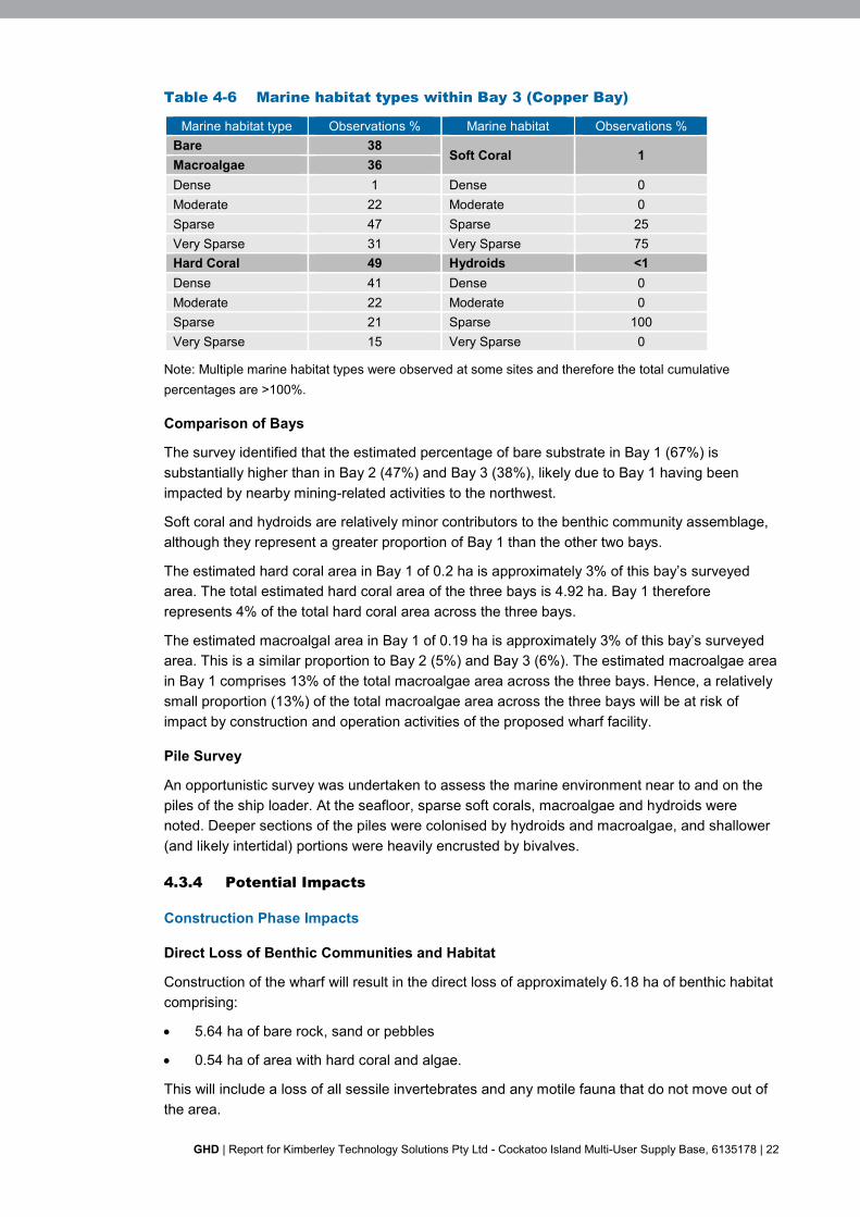
Table 4-6 Marine habitat types within Bay 3 (Copper Bay)
Marine habitat type Observations % Marine habitat Observations %Bare 38
Soft Coral 1Macroalgae 36Dense 1 Dense 0Moderate 22 Moderate 0Sparse 47 Sparse 25Very Sparse 31 Very Sparse 75Hard Coral 49 Hydroids <1Dense 41 Dense 0Moderate 22 Moderate 0Sparse 21 Sparse 100Very Sparse 15 Very Sparse 0
Note: Multiple marine habitat types were observed at some sites and therefore the total cumulativepercentages are >100%.
Comparison of Bays
The survey identified that the estimated percentage of bare substrate in Bay 1 (67%) issubstantially higher than in Bay 2 (47%) and Bay 3 (38%), likely due to Bay 1 having beenimpacted by nearby mining-related activities to the northwest.
Soft coral and hydroids are relatively minor contributors to the benthic community assemblage,although they represent a greater proportion of Bay 1 than the other two bays.
The estimated hard coral area in Bay 1 of 0.2 ha is approximately 3% of this bay’s surveyedarea. The total estimated hard coral area of the three bays is 4.92 ha. Bay 1 thereforerepresents 4% of the total hard coral area across the three bays.
The estimated macroalgal area in Bay 1 of 0.19 ha is approximately 3% of this bay’s surveyedarea. This is a similar proportion to Bay 2 (5%) and Bay 3 (6%). The estimated macroalgae areain Bay 1 comprises 13% of the total macroalgae area across the three bays. Hence, a relativelysmall proportion (13%) of the total macroalgae area across the three bays will be at risk ofimpact by construction and operation activities of the proposed wharf facility.
Pile Survey
An opportunistic survey was undertaken to assess the marine environment near to and on thepiles of the ship loader. At the seafloor, sparse soft corals, macroalgae and hydroids werenoted. Deeper sections of the piles were colonised by hydroids and macroalgae, and shallower(and likely intertidal) portions were heavily encrusted by bivalves.
4.3.4 Potential Impacts
Construction Phase Impacts
Direct Loss of Benthic Communities and Habitat
Construction of the wharf will result in the direct loss of approximately 6.18 ha of benthic habitatcomprising:
5.64 ha of bare rock, sand or pebbles
0.54 ha of area with hard coral and algae.
This will include a loss of all sessile invertebrates and any motile fauna that do not move out ofthe area.

GHD | Report for Kimberley Technology Solutions Pty Ltd - Cockatoo Island Multi-User Supply Base, 6135178 | 23
The reclaimed area of the bay will be largely sealed by sheet piling prior to the area being filledwith waste rock, and it is unlikely that material will disperse and smother any areas outside ofthe bay.
A barge with piling capabilities will be required for the proposed works, which will need to beanchored to complete the works. Repeated anchoring will physically disturb benthiccommunities and habitats.
Reduction in Marine Environmental Quality
A temporary reduction in water quality during construction may occur during drilling of the piles,inserting and anchoring of the sheet piles and placement of fill material. A reduction in waterquality may occur through re-suspension of fine material that could smother benthic habitats,reducing the light climate reaching photosynthetic organisms.
During construction, a number of solid and liquid wastes will be generated on both land and anyvessels, including sewage, bilge waters, cooling waters, deck drainage, food wastes, lubricatingoils, hydraulic oils, and excess concrete and asphalt. If released into the marine environment,hazardous and non-hazardous wastes and discharges could affect benthic communities andhabitats through localised toxic effects and reduction in water quality.
Introduction of Invasive Marine Species
Vessels and marine equipment will be required during construction. Invasive marine speciescan be carried by the vessel in ballast tanks, biofouling on the hull and internal systems, and insediments collected around marine equipment. A successful translocation of an invasive marinespecies could out-compete the existing benthic communities.
Post-Construction and Operational Phase Impacts
Loss of Benthic Communities and Habitat
The floating pontoon and any moored vessels at the pontoon will reduce light reaching theseabed beneath. Any photosynthetic benthic communities such as hard coral or algae may beeffected by the reduced light climate.
No anchoring during operations is anticipated, as vessels will moor alongside the pontoon.
Gain of Benthic Communities and Habitat
Based on observations of flora and fauna living on or around the existing ship loader piles, it isanticipated that a similar community assemblage will colonise the proposed wharf infrastructure.Further, colonisation of the wharf structure by hard corals may occur, particularly along theeastern portion of Bay 1 where some hard corals currently occur. As the majority of the subtidalenvironment is dominated by unconsolidated sediments, it is likely that these hard structures willbe colonised quickly due to its limited availability in the wider area.
Reduction in Marine Environmental Quality
A number of solid and liquid wastes will be generated during operations on the wharf andvisiting vessels, and hazardous materials will be stored on the wharf. These include marine gasoil, sewage, bilge waters, cooling waters, deck drainage, food wastes, lubricating oils, hydraulicoils and cleaning fluids. If released into the marine environment, hazardous and non-hazardouswastes and discharges could affect benthic communities and habitats through localised toxiceffects and reduction in water quality.

GHD | Report for Kimberley Technology Solutions Pty Ltd - Cockatoo Island Multi-User Supply Base, 6135178 | 24
4.3.5 Assessment of Impacts
The planned activities are unlikely to have a significant impact on benthic communities andhabitats due to a number of factors, including:
The expected very small loss of benthic primary producing habitat within the bay of 0.54 haof hard coral and algae
Adjacent bays have considerately benthic habitat of conservation value
No dredging is required
Fill material will be benign mine waste with little fine sediment content and no knowncontaminants
The floating pontoon and any operational vessels will be in deep waters and will not shadeareas with benthic photosynthesisers such as hard coral or algae
Any accidental spillages or releases of wastes or discharges will quickly disperse due tothe large tidal range of the area
Additional habitats will become available for colonisation by marine flora and fauna.
4.3.6 Mitigation
Potential construction impacts will be reduced through the following measures:
Development of a Construction Environmental Management Plan to minimise risks to thesurrounding environment and to provide monitoring during construction
Construction vessels will where possible limit their anchoring to areas that will be directlyimpacted in the reclamation process
Use of local construction vessels to reduce the likelihood of translocating marine pestsfrom high risk geographical areas
Construction vessels will follow relevant Australian and international regulations, includingMARPOL Marine Orders and Sewage Prevention Pollution Certificate, which include allhazardous materials being stored with secondary containment, with continuous bunding ordrip trays around machinery or equipment with the potential to leak hazardous materials
Construction vessels will have current MARPOL-compliant Shipboard Oil PollutionEmergency Plan (SOPEP) and Shipboard Marine Pollution Emergency Plan (SMPEP – fornoxious liquids)
Construction vessel equipment and machinery will be maintained on a PlannedMaintenance System to avoid any unplanned discharges to the marine environment
There will be no discharge of untreated or macerated sewage or food wastes from vessels
Where possible, non-toxic chemicals will be used
All wastes will be stored on-board and transferred to the mainland for disposal at a licensedfacility as per the vessels Waste Management Plan
Waste containers (bins etc.) provided for waste containment will be clearly marked andsuitably covered to prevent material being blown overboard.

GHD | Report for Kimberley Technology Solutions Pty Ltd - Cockatoo Island Multi-User Supply Base, 6135178 | 25
Potential operational impacts will be reduced through the following measures:
Development of an Operations Environmental Management Plan to define techniques tominimise risks to the surrounding environment
Operational vessels will not anchor
Waste containers on the wharf (bins etc.) will be clearly marked and suitably covered toprevent material being blown into the marine environment. Wastes will be appropriatelydisposed of on the Island or transferred to the mainland for disposal at a licenced facility
Hazardous materials stored on the wharf (e.g. marine gas oil, diesel, hydraulic fluids etc.)will be stored in self bunded tanks or in drums within bunded and covered areas
Sewage will be transferred to the airfield septic tank system
Putrescible wastes will be disposed to the current licenced landfill
Waste hydrocarbons will be removed from the Island for reprocessing. Wastes that cannotbe disposed onsite will be transferred to the mainland by barge for disposal.
4.3.7 Predicted Outcomes
The Project will result in the direct loss of 0.54 ha of hard coral and algae, of which 0.3 ha islargely very sparse hard coral. Species are represented in adjacent bays and in higher densitiesand coverage. Some colonisation by marine species will occur on the new sheet piling. As thisbay has very little primary producer habitat compared to the adjacent bays, there is unlikely tobe a significant impact to local biological diversity and ecological integrity.
4.4 Key Environmental Factor - Coastal Processes
4.4.1 EPA Objective
To maintain the geophysical processes that shape coastal morphology so that theenvironmental values of the coast are protected.
4.4.2 Policy and Guidance
Environmental Factor Guideline – Coastal Processes (EPA 2016j).
4.4.3 Receiving Environment
Baseline studies relevant to the Proposal are provided in Table 4-7.
Table 4-7 Baseline studies – coastal processes
Consultant Study Name
M P Rogers andAssociates PL (2011)
Cockatoo Island Seawall Decommissioning and Closure Plan
MScience (2011) Cockatoo Island Marine Closure Knowledge Base and CompletionCriteria
Tidal variations at Cockatoo Island are semi-diurnal and macrotidal, meaning two high and twolow tides are typically experienced within a 24-hour period and that the difference between lowand high tides are in excess of 4 m. Tidal planes are detailed in Table 4-8 for different verticaldatums (MRA 2011).
The large variation in tidal levels, particularly during spring conditions, result in relatively highambient current speeds around Cockatoo Island. Purcell (2002) indicated that tidal currentsaround 5 m/s can occur in the Buccaneer Archipelago.

GHD | Report for Kimberley Technology Solutions Pty Ltd - Cockatoo Island Multi-User Supply Base, 6135178 | 26
Table 4-8 Local tidal planes
Tidal Plane m CID1 m CD2 m AHD
Highest Astronomical Tide +10.1 +10.9 +6.2
Mean High Water Spring +9.1 +9.9 +5.2
Mean High Water Neap +6.0 +6.8 +2.1
Mean Sea Level +4.7 +5.5 +0.8
Mean Low Water Neap +3.3 +4.1 -0.6
Mean Low Water Spring +0.2 +1.0 -3.7
Lowest Astronomical Tide (LAT) -0.8 0.0 -4.7
1. CID (Cockatoo Island Datum) is approximately 0.8m above CD (Chart Datum) and 3.9m below AHD (AustralianHeight Datum)
2. CD is approximately LAT
The ambient wave climate of Yampi Sound and the Buccaneer Archipelago is very mild due tothe protection from southerly and south westerly swells by the Dampier Peninsula (MScience2011). The southern side of Cockatoo Island is further protected from wave energy due to shortwave fetch and protection offered by other offshore Islands. The largest waves are experiencedduring cyclonic events, which are frequent in this region, and are capable of creating damagingwave conditions (MScience 2011).
The wharf will be located in Bay 1 on the southern side of Cockatoo Island (Figure 4-1). Thegeomorphology of the bay is defined by steeply sloped rocky outcrops and characterised byintertidal and subtidal platforms typically between -2.0 mCD and 0 mCD (Figure 4-5). Theseaward slope of the platform is steep and bed levels in the adjacent Yampi Sound reach -30 mCD to -40 mCD.
Figure 4-5 Indicative bathymetry based on interpolation of data from C-MAP(Jeppesen Charts). Levels referenced to Chart Datum
A small sandy beach occurs at the apex of Bay 1 (Figure 4-6). This was further supported bysubstrate assessment that indicates that Bay 1 has mainly a thin sandy substrate overlying arock base (Figure 4-1).
Bay 1

GHD | Report for Kimberley Technology Solutions Pty Ltd - Cockatoo Island Multi-User Supply Base, 6135178 | 27
Figure 4-6 Bay 1 site photograph
Sediment transport processes around Cockatoo Island are expected to be primarily driven bytidal currents due to the high tidal ranges and low ambient wave energy.
Evidence of current patterns in geomorphological features at Cockatoo Island is limited due tothe lack of sediment and sedimentary landforms. The main sedimentary feature is the shallowsubtidal and intertidal beach at the head of the bay as described above, which has formed froma combination of lithogenic and biogenic sediment sources.
4.4.4 Potential Impacts
The wharf has the potential to locally alter current speeds and patterns that may impact:
Patterns of erosion and accretion
Benthic communities and habitats.
4.4.5 Assessment of Impacts
The wharf will be constructed as an earth-filled sheet-pile retained hardstand. The wharf will belocated adjacent to existing areas of steep rock within the bay and will run almost parallel to theshoreline. No dredging will be required.
Location of the wharf adjacent to existing areas of steep rock will result in a minimal impact onlocal current speeds and patterns, as the sheet-pile hardstand will have a similar vertical profileto existing geological formations.
The wharf will not create tidally restricted bodies of water that are separated from Yampi Soundand consequently there will be no impact on coastal hydrodynamics as tidal currentcharacteristics will not significantly change.
The wharf will be sited across the existing beach areas and this may affect sediment supplyfrom the beach to the subtidal platform. Given the small size of the beach, sediment movementis unlikely to be significant.
The installation of sheet-piles is likely to have only localised impacts and may result in someerosion of sand and silts around the pile.
4.4.6 Mitigation
The design and location of the wharf removes the need for any additional mitigation.
4.4.7 Predicted Outcomes
The wharf will run parallel to the shoreline and will not significantly affect or interrupt longshorecurrent movements or existing coastal processes.
Any residual impacts on sedimentation, geomorphology, current speeds and patterns will belocalised and restricted to the vicinity of the wharf.

GHD | Report for Kimberley Technology Solutions Pty Ltd - Cockatoo Island Multi-User Supply Base, 6135178 | 28
4.5 Key Environmental Factor - Marine Environmental Quality
4.5.1 EPA Objective
To maintain the quality of water, sediment and biota so that environmental values are protected.
4.5.2 Policy and Guidance
Environmental Factor Guideline – Marine Environmental Quality (EPA 2016h)
Technical Guidance – Protecting the quality of Western Australia’s marine environment(EPA 2016i).
4.5.3 Receiving Environment
Baseline studies relevant to the Proposal are provided in Table 4-9.
Table 4-9 Baseline studies – marine environmental quality
Consultant Study Name
Ecologia (2003) Cockatoo Island Marine Monitoring Reports
MScience (2010) Cockatoo Island Marine Monitoring - Monitoring Survey Reports
Marine environmental surveys have historically focussed on physical parameters of marinesediments and water in relation to the seawall activities. A summary of the available marineenvironmental quality information taken from ‘baseline’ sites and not related to historical impactsassociated with seawall activities include (MScience 2010):
Seawater
Total suspended solids ranging between 1 and 7 mg/L
Secchi depths ranging between 2.3 and 6.6 m.
Marine Sediments
Total iron content ranging between 1.46 to 7.13 mg/kg.
No known marine water quality investigations have been undertaken in the area of the proposedwharf, and sediment contaminant levels have not been investigated. However, the absence ofhistorical use of this area suggests that marine sediments are likely to be high quality with lowor absent contamination levels. Similarly, due to a lack of anthropogenic inputs and large tidalregime, water quality is expected to be high with low or absent contamination levels. Turbidityand total suspended solids are known to be variable and influenced by large tides andseasonally high rainfall.
The dominant benthic habitat in the area of the wharf is unvegetated sandy substrate (67%).
4.5.4 Potential Impacts
Construction Phase Impacts
Reduction in Marine Environmental Quality
A temporary reduction in water quality during construction may occur during drilling of the piles,inserting and anchoring of the sheet piles and placement of fill material. A reduction in waterquality may occur through re-suspension of fine material that could smother benthic habitats,reducing the light climate reaching photosynthetic organisms.

GHD | Report for Kimberley Technology Solutions Pty Ltd - Cockatoo Island Multi-User Supply Base, 6135178 | 29
During construction, a number of solid and liquid wastes will be generated on both land and anyvessels, including sewage, bilge waters, cooling waters, deck drainage, food wastes, lubricatingoils, hydraulic oils, and excess concrete and asphalt. If released into the marine environment,hazardous and non-hazardous wastes and discharges could affect benthic communities andhabitats through localised toxic effects and reduction in water quality.
Post-Construction and Operational Phase Impacts
Reduction in Marine Environmental Quality
A number of solid and liquid wastes will be generated during operations on the wharf andvisiting vessels, and hazardous materials will be stored on the wharf. These include marine gasoil, sewage, bilge waters, cooling waters, deck drainage, food wastes, lubricating oils, hydraulicoils and cleaning fluids. If released into the marine environment, hazardous and non-hazardouswastes and discharges could affect benthic communities and habitats through localised toxiceffects and reduction in water quality.
4.5.5 Assessment of Impacts
The planned activities are unlikely to have a significant impact on marine environmental qualitydue to a number of factors, including:
No dredging is required
Fill material will be largely benign mine waste with little fine sediment content and noknown contaminants
Fluxes in total suspended solids are common in the wider area and are related to largetidal movements and seasonally high rainfall
Any accidental spillages or releases of wastes or discharges will quickly disperse due tothe large tidal range of the area.
4.5.6 Mitigation
Potential construction impacts will be reduced through the following measures:
Development of a Construction Environmental Management Plan to minimise risks to thesurrounding environment and to provide monitoring during construction
Construction vessels will follow relevant Australian and international regulations, includingMARPOL Marine Orders and Sewage Prevention Pollution Certificate, which include allhazardous materials being stored with secondary containment, with continuous bunding ordrip trays around machinery or equipment with the potential to leak hazardous materials
Construction vessels will have current MARPOL-compliant Shipboard Oil PollutionEmergency Plan (SOPEP) and Shipboard Marine Pollution Emergency Plan (SMPEP – fornoxious liquids)
Construction vessel equipment and machinery will be maintained on a PlannedMaintenance System to avoid any unplanned discharges to the marine environment
There will be no discharge of untreated or macerated sewage or food wastes from vessels
Where possible, non-toxic chemicals will be used
All wastes will be stored on-board and transferred to the mainland for disposal at a licensedfacility as per the vessels Waste Management Plan
Waste containers (bins etc.) provided for waste containment will be clearly marked andsuitably covered to prevent material being blown overboard.

GHD | Report for Kimberley Technology Solutions Pty Ltd - Cockatoo Island Multi-User Supply Base, 6135178 | 30
Potential operational impacts will be reduced through the following measures:
Development of an Operations Environmental Management Plan to define techniques tominimise risks to the surrounding environment
Waste containers on the wharf (bins etc.) will be clearly marked and suitably covered toprevent material being blown into the marine environment. Wastes will be appropriatelydisposed of on the Island or transferred to the mainland for disposal at a licenced facility
Hazardous materials stored on the wharf (e.g. marine gas oil, diesel, hydraulic fluids etc.)will be stored in self bunded tanks or in drums within bunded and covered areas
Sewage will be transferred to the airfield septic tank system
Putrescible wastes will be disposed to the current licenced landfill
Waste hydrocarbons will be removed from the Island for reprocessing. Wastes that cannotbe disposed onsite will be transferred to the mainland by barge for disposal.
4.5.7 Predicted Outcomes
The Proposal does not involve dredging or any planned discharge and is not expected tointerrupt longshore current movements or existing coastal processes.
Impacts will be largely confined to the construction phase and limited to the immediate area ofconstruction that is largely dominated by unvegetated sandy environs. Further, due to the largetidal regime and seasonally high rainfall, fluxes in total suspended solids and turbidity arecommon.
There is not expected to be any significant risk to maintaining environmental values of thewater, sediment and biota through the construction or operational phases.
4.6 Key Environmental Factor - Marine Fauna
4.6.1 EPA Objective
To protect marine fauna so that biological diversity and ecological integrity are maintained.
4.6.2 Policy and Guidance
Environmental Factor Guideline – Marine Fauna (EPA 2016g).
4.6.3 Receiving Environment
Baseline studies relevant to the Proposal are provided in Table 4-10.
Table 4-10 Baseline studies – marine fauna
Consultant Study Name
GHD (2017a) –Appendix A
Cockatoo Island Multi-User Supply Base. Technical Study - Marine Flora and Fauna
Marine Mammals
Nine species of protected or listed marine mammals may potentially occur within the Proposalarea of which one species, the Humpback Whale, is listed as Threatened under the EPBC Act(Table 4-11).

GHD | Report for Kimberley Technology Solutions Pty Ltd - Cockatoo Island Multi-User Supply Base, 6135178 | 31
Table 4-11 Conservation significant marine mammals
Common name Scientific nameEPBC listing DPaW
PresenceListedthreatened
Listedmigratory
Othermatters
Schedule/ Ranking
Whales
Humpback Whale Megapteranovaeangliae
VU CD (D1) B
Bryde’s Whale Balaenoptera edeni M
Dolphins
Common Dolphin,Short-beakedCommon Dolphin
Delphinus delphis M
Irrawaddy Dolphin,Australian SnubfinDolphin
Orcaella brevirostris P4 M
Indo-PacificHumpback Dolphin
Sousa chinensis B
Spotted Dolphin,Pantropical SpottedDolphin
Stenella attenuata M
Indian OceanBottlenose Dolphin,Spotted BottlenoseDolphin
Tursiops aduncus L
Bottlenose Dolphin Tursiops truncatess. str.
M
Sirrenians
Dugong Dugong dugon L
Note: ‘B’: Breeding known to occur within area.‘L’: Species or species habitat likely to occur within area.‘M’: Species or species habitat may occur within area.
‘CD’: Conservation dependant.‘VU’: Vulnerable.‘SP’: Specially protected.P1-P4: Priority 1 – 4.
Humpback Whale
Humpback Whales occur throughout Australian waters with their distribution influenced by theirmigratory pathways and aggregation areas for resting, breeding and calving. Humpbacks arrivein the coastal waters of the Kimberley after summer to breed and calve before returning to theAntarctic after the winter season has passed. Humpback Whales are likely be in deeper watersof the Proposal area.
Bryde’s Whale
Byrde’s Whale is the second smallest of the baleen whales. They inhabit tropical and warmtemperate waters and generally travel alone or in pairs. This species appears to be limited tothe 200 m depth contour, moving along the coast in response to the availability of suitable prey,while the offshore form is found in deeper waters (500 to 1,000 m) (Best 1977). Because of itssmall population, lack of sightings and preference for deeper water, it is unlikely to beencountered in the Proposal area.
Dolphins
Six species of dolphin listed under the EPBC Act were identified as potentially occurring in theProposal area with three listed as Migratory and all as ‘other matters’.

GHD | Report for Kimberley Technology Solutions Pty Ltd - Cockatoo Island Multi-User Supply Base, 6135178 | 32
Common Dolphins are recorded in all Australian waters and are not thought to be migratory.They are associated with high topographical relief of the ocean floor, drop-offs and upwellingareas, however, there are no known key areas for this species in Australia.
Redescription and genetic research has resulted in the Irrawaddy Dolphin being renamed theAustralian Snubfin Dolphin. This dolphin is primarily found in nearshore habitats, but has beenrecorded up to 23 km offshore. Beagle Bay and Pender Bay are important areas for theAustralian Snubfin Dolphin (DotEE 2016).
The Indo-Pacific Humpback Dolphin is primarily found in nearshore habitats, such as thoseassociated with the Buccaneer Archipelago (DotEE 2016). Indo-Pacific Humpback Dolphinstypically occur in open waters around coasts and Islands, generally in less than 20 m waterdepth (Parra et al. 2002).
Little is known about the distribution of the Spotted Dolphin in the Kimberley region, althoughthey have been recorded at the shelf edge and shelf slope area of the Browse Basin in large,high energy, mixed schools in association with tuna, seabirds and other pelagic cetaceans.Small groups of Stenella species have also been observed resting in nearshore areas of coaston the lee side of bays (DSEWPaC 2012a).
The Bottlenose Dolphin is a cosmopolitan species found in all Australian waters in coastal,estuarine and pelagic settings. Bottlenose Dolphins have been observed during surveys byJenner and Jenner (2009) between Cape Leveque (north of Broome) and Scott Reef in June,July, October and November 2008. The Spotted Bottlenose Dolphin is widely distributed in Indo-Pacific coastal waters, however there is limited information on the distribution and population ofthe Arafura/Timor sea population.
Due to shallow water preferences, the Irrawaddy/Australian Snubfin Dolphin, Indo-PacificHumpback Dolphin and the Bottlenose Dolphins are likely to be present all year round near theProposal area. Due to its depth preferences, the Spotted Dolphin is unlikely to occur.
Dugong
North-western Australia is thought to have one of the largest populations of Dugongs in theworld and are largely sighted feeding in wide and shallow seagrass beds but also in estuarinestreams (DSEWPaC 2012b). Regional sightings pooled from 1996 to 2008 show some sightingsaround Cockatoo and Irvine Islands but notably less than that around the Dampier Peninsular,Derby and Walcott Inlet (Holley and Prince 2011). Due to the Dugongs presence being largelycorrelated with seagrass beds, it is unlikely to be found within the Proposal area but is likely tobe found in the wider coastal area.
Fish
Thirty-three species of protected or listed fish may occur near the Proposal area, of which fivespecies are listed as Threatened (Table 4-12).
Whale Shark
Whale Sharks have a broad distribution in tropical and warm temperate seas, and feed onphytoplankton, macroalgae, zooplankton, krill and small nektonic life, such as small squid orvertebrates. Whale Sharks undertake a well-known annual migration between March and Juneto aggregate in Ningaloo Marine Park and believed to be linked to localised seasonal peaks ofcoral spawning that occurs around March/April each year (Woodside 2011). Following thisperiod, observers have recorded Whale Sharks migrating northwest to the Indian Ocean, ordirectly north to Sumatra and Java, or northeast passing within the region of Scott Reef and theBrowse Basin and travelling along the 200 m contour (Woodside 2011). Due to the preferencefor deeper waters, the Whale Shark is unlikely to be found in the Proposal area.

GHD | Report for Kimberley Technology Solutions Pty Ltd - Cockatoo Island Multi-User Supply Base, 6135178 | 33
Table 4-12 Conservation significant fish
Common Name Scientific NameEPBC Listing DPaW
PresenceListedThreatened
Listedmigratory
Othermatters
Schedule/Ranking
Whale Shark Rhincodon typus VU SP M
Great White Shark Carcharodoncarcharias VU
VU M
Green Sawfish Pristis zijsron VU VU K
LargetoothedSawfish Pristis pristis VU
P1 K
Dwarf Sawfish Pristis clavata VU P3 K
Reef Manta Ray Manta alfredi K
Giant Manta Ray Manta birostris M
Killer Whale, Orca Orcinus orca M
Northern RiverShark, New GuineaRiver Shark
Glyphis garricki ENP1
M
25 other species of pipefish and seadragon M
Note: ‘K’: Species or species habitat known to occurwithin area.‘M’: Species or species habitat may occur within area.
CD’: Conservation dependant.‘VU’: Vulnerable.‘SP’: Specially protected.P1-P4: Priority 1 – 4.
Great White Shark
In Australian waters, Great White Sharks are widely but not evenly distributed, and sightings areconsidered uncommon to rare compared to most other large sharks (CITES 2004). Great WhiteSharks can be found in areas close to inshore around rocky reefs, surf beaches and shallowcoastal bays, and in outer continental shelf and slope areas (Pogonoski et al. 2002). It isunlikely that they would be present in the Proposal area.
Largetooth Sawfish
This species has been recorded in riverine and marine environments across northern Australiaand is known to have occurred within most of the subtropical areas between Cape Keraudren inWestern Australia and Princess Charlotte Bay in Queensland. It is known to occur up to 100 kmoffshore. The generally accepted model of movement and migration of Largetooth Sawfish inAustralian waters is that young are born at the mouths of rivers and in estuaries and thenmigrate up river where they spend the first several years of life (Thorburn et al. 2004). As theyreach maturity, they move out of the rivers and into the marine environment. Given this speciesknown distribution, it is possible that they can occur in the Project area.
Green Sawfish
The DotE (2015) reports that Green Sawfish are distributed from the Whitsundays to Shark Bay.Individuals have been recorded from inshore coastal environments and estuaries to offshoredeep waters (Stevens et al. 2005). Given this species known distribution, it is possible that theycould occur in the Proposal area.

GHD | Report for Kimberley Technology Solutions Pty Ltd - Cockatoo Island Multi-User Supply Base, 6135178 | 34
Dwarf Sawfish
The distribution of Dwarf Sawfish is considered to be restricted to northern Australia, rangingfrom northern Queensland to the Pilbara coastline. Sawfish generally inhabit shallow coastalwaters and estuaries, which are utilised as nurseries for juveniles. Surveys have found mostcaptures of Dwarf Sawfish occur over soft sediment environments (DotE 2015). Given theknown distribution of this species, it is possible that they could occur in the Proposal area.
Manta Rays
Manta Rays commonly occur throughout the majority of Australian coastlines. The Reef andGiant Manta Ray may be found in the Proposal area.
Killer Whales
Killer Whales are thought to be the most cosmopolitan of all cetaceans in Australasian watersand have been sighted along the Kimberley coast (Kimberley Society 2010). Although notcommon, the Killer Whale may occur in the Proposal area.
Northern River Shark
The DotE (2015) reports that the Northern River Shark utilise rivers, tidal sections of largetropical estuarine systems and macrotidal embayment’s, as well as inshore and offshore marinehabitats. Given this species known distribution, it is possible that they could occur in theProposal area.
Seahorses, Seadragons and Pipefish
Twenty-five species of Syngnathids have been identified that could potentially occur within theProposal area. Although uncommon, these species are expected to occur in shallow coastalareas. However as preferable habitats (seagrass) are likely to be sparse in the area, theoccurrence of Syngnathids in the Proposal area is unlikely.
Marine Reptiles
Sixteen species of protected or listed marine reptiles potentially occur within the Proposal area,of which five species are listed as Threatened (Table 4-13). Conservation significant marinereptiles are described below.
Loggerhead Turtle
Loggerhead Turtles are globally distributed, occurring within coral, rocky reef, seagrass andmuddy bay habitats throughout eastern, northern and western Australia (DotEE 2016a). Nestingis concentrated in southern Queensland and from Shark Bay to the North West Cape (Ningaloo)in WA, although foraging areas are more widely distributed. There has also been one reportednesting at Ashmore Reef (Guinea 1995). Given the absence of important areas for feeding andnesting, it is unlikely that Loggerhead Turtles will be present in the Proposal area.

GHD | Report for Kimberley Technology Solutions Pty Ltd - Cockatoo Island Multi-User Supply Base, 6135178 | 35
Table 4-13 Conservation significant marine reptiles
CommonName Scientific Name
EPBC Listing DPaWPresenceListed
ThreatenedListed
MigratoryOther
mattersSchedule/Ranking
Turtles
LoggerheadTurtle Caretta caretta
EN (D3) K
Green Turtle Chelonia mydas VU (D3) C
LeatherbackTurtle
Dermochelyscoriacea
VU (D3) L
FlatbackTurtle Natator depressus VU (D3) C
HawksbillTurtle
Eretmochelysimbricata VU (D3) L
Crocodiles
SaltwaterCrocodile Crocodylus porosus SP (D3) L
FreshwaterCrocodile Crocodylus johnstoni
SP (S3) M
Seasnakes
9 species of seasnake M
Note: Presence identified by EPBC Protected MatterSearch Tool (PMST)‘C’: Congregation or aggregation known to occurwithin area.‘K’: Species or species habitat known to occur withinarea.‘L’: Species or species habitat likely to occur withinarea.
‘M’: Species or species habitat may occur withinarea.‘EN’: Endangered.‘VU’: Vulnerable.‘SP’: Specially protected.
Green Turtle
Green Turtles are the most widespread and abundant turtle species in Western Australiawaters, nesting from the Ningaloo coast to the Kimberley Islands (Prince 1994). There are twoknown migration pathways for Green Turtles from Scott Reef and Browse Island to theAustralian mainland coast – either travelling north‐east to the Bonaparte Archipelago and thenfollowing the coast to the Northern Territory; or travelling south to Cape Leveque and along thecoast to the Pilbara (Guinea 2010). Satellite tracking has shown that Green Turtles nesting onBrowse Island and Sandy Island (Scott Reef) feed between 200 km and 1000 km from theirnesting beaches (Pendoley 2005). In surveys by RPS (2010) from 2009-2010 in the DampierPeninsula and Lacepede Islands, the majority of Green Turtles migrated north-east along theKimberley coast in the post-nesting migration period (from approximately April). Given theknown migration route and use of shallow benthic habitats for foraging, it is likely that GreenTurtles could occur in the Proposal area.
Leatherback Turtle
Leatherback Turtles are pelagic feeders, found in tropical, subtropical and temperate watersthroughout the world. This species regularly forages over Australian continental shelf watersand has been reported in south-western WA waters (DotEE 2016a). There are no major nestingareas recorded in Australia, although there are scattered records in the NT, Queensland andNSW (DotEE 2016a). Given the absence of important areas for feeding and nesting, it is highlyunlikely that Leatherback Turtles occur in the Proposal area.
GHD | Report for Kimberley Technology Solutions Pty Ltd - Cockatoo Island Multi-User Supply Base, 6135178 | 36
Flatback Turtle
The Flatback Turtle is one of the two turtle species without a global distribution, found only intropical waters of northern Australia, Papua New Guinea and Irian Jaya, with nesting confinedto Australia (Limpus 2007). The Kimberley region is an important nesting area, with significantnesting occurring on the Lacepede Islands. Studies of Flatback Turtles during the 2009-2010nesting season on the Lacepede Islands tracked several individuals via satellite tags during theinter-nesting and post-nesting periods (RPS 2010). Individuals were found to remain within50 km of the Islands during the inter-nesting period. During post-nesting migration, turtlesstayed in shallow depths, travelling from 17 km to up to 1,005 km, mainly staying within WAwaters, such as Adele Island, Lacepede Island and the Maret Islands (north-east of Derby).Migration pathways of Flatback Turtles nesting in rookeries further south, such as Port Hedland,generally pass the Dampier Peninsula to probable foraging grounds in the Kimberley region(RPS 2010). Given the known migration route and use of shallow benthic habitats for foraging, itis likely that Flatback Turtles could occur in the Proposal area.
Hawksbill Turtle
The species has a global distribution throughout tropical, sub-tropical and temperate waters,with nesting largely concentrated on sub-tropical beaches (Marquex 1990). Adults tend toforage in tropical tidal and sub-tidal coral and rock reef habitats where they primarily feed onsponges and algae (DotEE 2017). Key nesting and inter-nesting areas include the DampierArchipelago, Barrow Island, Lowendal and Thevenard Islands, with areas of Ashmore Reef,Cartier Island and Sandy Island. Given this turtle’s regional presence and use of reefs forforaging, it is likely that the Hawksbill Turtle could occur in the Proposal area.Crocodiles
Saltwater and Freshwater Crocodiles are known to inhabit marine, coastal and riverine habitatsfrom Port Hedland to Townsville (Department of Conservation and Land Management 2004).Anecdotal observations from Cockatoo Island confirm that Saltwater Crocodiles occurinfrequently near the Proposal area. Due to the lack of freshwater habitats, the FreshwaterCrocodile is unlikely to occur in the Proposal area.
4.6.4 Potential Impacts
Construction Phase Impacts
Direct Loss of Benthic Communities, Habitat and Waters
Construction of the wharf will result in the direct loss of approximately 6.18 ha of benthic habitatcomprising:
5.64 ha of bare rock, sand or pebbles
0.54 ha of area with hard coral and algae.
This area also includes the sub-tidal and intertidal waters above the benthic communities.
These habitats may support marine fauna that use the habitats as food sources, refugia,spawning and nursery grounds.
A barge with piling capabilities will be required for the proposed works, which will need to beanchored to complete the works. Repeated anchoring will physically disturb benthiccommunities and habitats.

GHD | Report for Kimberley Technology Solutions Pty Ltd - Cockatoo Island Multi-User Supply Base, 6135178 | 37
Reduction in Marine Environmental Quality
A temporary reduction in water quality during construction may occur during drilling of the piles,inserting and anchoring of the sheet piles and placement of fill material. A reduction in waterquality may occur through re-suspension of fine material that could smother benthic habitats,reducing the light climate reaching photosynthetic organisms.
During construction, a number of solid and liquid wastes will be generated on both land and anyvessels, including sewage, bilge waters, cooling waters, deck drainage, food wastes, lubricatingoils, hydraulic oils, and excess concrete and asphalt. If released into the marine environment,hazardous and non-hazardous wastes and discharges could affect benthic communities andhabitats through localised toxic effects and reduction in water quality.
Introduction of Invasive Marine Species
Vessels and marine equipment will be required during construction. Invasive marine speciescan be carried by the vessel in ballast tanks, biofouling on the hull and internal systems, and insediments collected around marine equipment. A successful translocation of an invasive marinespecies could out-compete the existing benthic communities.
Marine Fauna Interaction
The physical presence and movement of construction vessels and reclamation of the bay hasthe potential to impact marine fauna. Impacts may range from behavioural (e.g. changes insurfacing patterns, swimming speed, duration underwater) to injury (e.g. propeller lacerations)or mortality (e.g. vessel strike, crushed by rocks).
Noise Emissions
During construction, underwater noise will be generated by vessel operations includingpropellers/thrusters and associated machinery/engines, piling, securing the sheet piles and thereclamation process.
Underwater noise has the potential to adversely affect marine fauna and in extreme casescause physiological harm. Underwater noise may impact marine fauna by:
Causing behavioural changes including displacement from biologically important habitatareas (such as feeding, resting, breeding, calving and nursery sites)
Masking or interference with other biologically important sounds such as communication orecholocation systems used by certain cetaceans for navigation and location of prey
Causing physical injury to hearing and other internal organs
Indirectly impacting predator or prey species.
Post-Construction and Operational Phase Impacts
Changes to Benthic Communities, Habitat and Waters
Post-construction, the benthic communities and habitats will be altered locally.
The floating pontoon and moored vessels at the pontoon will reduce light reaching the seabedbeneath. Any photosynthetic benthic communities such as hard coral or algae may be effectedby the reduced light climate, which may affect marine fauna that previously utilised this area.Conversely, shaded structures also attract some marine fauna species as an area of refuge.
Based on observations of flora and fauna living on or around the existing ship loader piles, it isanticipated that a similar community assemblage will colonise the proposed wharf infrastructure.

GHD | Report for Kimberley Technology Solutions Pty Ltd - Cockatoo Island Multi-User Supply Base, 6135178 | 38
This would eventually provide alternative food sources, habitat and refugia for some marinefauna species.
Reduction in Marine Environmental Quality
A number of solid and liquid wastes will be generated during operations on the wharf andvisiting vessels, and hazardous materials will be stored on the wharf. These include marine gasoil, sewage, bilge waters, cooling waters, deck drainage, food wastes, lubricating oils, hydraulicoils and cleaning fluids. If released into the marine environment, hazardous and non-hazardouswastes and discharges could affect marine fauna through direct toxicity, ingestion orentanglement.
Light Emissions
Operations could occur 24 hours a day and navigational and safety lighting will be required thatmay affect marine fauna behaviour.
Continuous lighting in the same location for an extended period may result in alterations tonormal marine fauna behaviour, as summarised below for each fauna group:
Fish and Zooplankton
Attraction of some fish and zooplankton species to light, which may alter local predator-preyinteractions (Milicich et al. 1992).
Marine Turtles
Disorientation of turtle hatchlings (Environment Protection Authority 2010)
Disorientation of nesting turtles (Environment Protection Authority 2010).
Seabirds
Attraction of some seabirds to illuminated structures or the attracted food sources(Marquennie et al. 2008).
Marine Fauna Interaction
During normal operations, there could be up to seven vessel movements to and from the Islandper week. Vessel movements have the potential to cause behavioural effects (e.g. changes insurfacing patterns, swimming speed, duration underwater) to injury (e.g. propeller lacerations)or mortality (e.g. vessel strike) to marine fauna.
Noise Emissions
During operations, underwater noise will be generated by the vessel operations and workshopactivities. Underwater noise may impact marine fauna by:
Causing behavioural changes including displacement from biologically important habitatareas (such as feeding, resting, breeding, calving and nursery sites)
Masking or interference with other biologically important sounds such as communication orecholocation systems used by certain cetaceans for navigation and location of prey
Causing physical injury to hearing and other internal organs
Indirectly impacting predator or prey species.

GHD | Report for Kimberley Technology Solutions Pty Ltd - Cockatoo Island Multi-User Supply Base, 6135178 | 39
4.6.5 Assessment of Impacts
The planned activities are unlikely to have a significant impact on marine fauna due to a numberof factors, including:
Previous activities within Cockatoo Islands marine environment involved wharfconstruction, ship movements and ship loading with no reported marine fauna strikes
The loss of the marine habitats will be partially offset with new colonisable areas andrefugia created by the sheet piling and floating pontoon
Adjacent bays have considerately more benthic habitats available for marine fauna usage
There are no known turtle nesting beaches on the Island
There is no known critical habitat for any conservation significant marine fauna within thebay
Filling of the bay will be staged from the shore and progressively move out to deeperwaters. This approach should provide audible and vibratory disturbance that will forcemotile marine fauna out of the area
No dredging is required
Construction vessels will largely be stationary once in the bay
Fill material will be largely benign mine waste with little fine sediment content and noknown contaminants
Any accidental spillages or releases of wastes or discharges will quickly disperse due tothe large tidal range of the area
Fluxes in total suspended solids are common in the wider area and are related to largetidal movements and seasonal high rainfalls.
4.6.6 Mitigation
Construction impacts will to be reduced through the following measures:
Development of a Construction Environmental Management Plan to minimise risks to thesurrounding environment and to provide monitoring during construction
Use of local construction vessels to reduce the likelihood of translocating marine pestsfrom high risk geographical areas
Construction vessels will follow relevant Australian and international regulations, includingMARPOL Marine Orders and Sewage Prevention Pollution Certificate, which include allhazardous materials being stored with secondary containment, with continuous bunding ordrip trays around machinery or equipment with the potential to leak hazardous materials
Construction vessels will have current MARPOL-compliant Shipboard Oil PollutionEmergency Plan (SOPEP) and Shipboard Marine Pollution Emergency Plan (SMPEP – fornoxious liquids)
Construction vessel equipment and machinery will be maintained on a PlannedMaintenance System to avoid any unplanned discharges to the marine environment
There will be no discharge of untreated or macerated sewage or food wastes from vessels
All wastes will be stored on-board and transferred to the mainland for disposal at a licensedfacility as per the vessels Waste Management Plan

GHD | Report for Kimberley Technology Solutions Pty Ltd - Cockatoo Island Multi-User Supply Base, 6135178 | 40
Waste containers (bins etc.) provided for waste containment will be clearly marked andsuitably covered to prevent material being blown overboard.
Marine fauna identification posters and Marine Fauna Sighting Datasheets will be madeavailable on-board construction vessels
Trained crew will maintain vigilant observation for marine cetaceans or turtles duringconstruction
Works will be timed to limit impacts to whales, dolphins, rays, turtles etc (i.e. outside ofmain migration timing)
In accordance with Part 8 of the EPBC Regulations (Vessels), all vessels must travel atless than 6 knots and minimise noise within the caution zone of a cetacean (150 m radiusfor dolphins, 300 m for whales) known to be in the area
In accordance with EPBC Act Policy Statement 2.1 Part A (DEWHA 2008), during pilingactivities:
o Precaution zones will be implemented (Observation (3+ km), Low Power (1 km) andShut down (500 m))
o Pre-start up visual observation of precaution zones (>30 minutes before soft start)
o Piling will not commence if cetaceans or turtles are within low power or shut-downzone
o Trained crew will maintain vigilant observation for marine cetaceans and turtleswithin precaution zones and vessel planned path throughout piling activities
o Piling will cease if cetacean or turtle enters shut-down zone
o Relevant crewmembers are briefed on EPBC Act Policy Statement requirements,soft start, start-up delay, operations and stop work procedures, nighttime and lowvisibility procedures.
Potential operational impacts will be reduced through the following measures:
Development of an Operations Environmental Management Plan to define techniques tominimise risks to the surrounding environment
Waste containers on the wharf (bins etc.) will be clearly marked and suitably covered toprevent material being blown into the marine environment. Wastes will be appropriatelydisposed of on the Island or transferred to the mainland for disposal at a licenced facility
Hazardous materials stored on the wharf (e.g. marine gas oil, diesel, hydraulic fluids etc.)will be stored in self-bunded tanks or in drums within bunded and covered areas
Vessel or wharf spot lights not required for safety purposes will be turned off or directedinboard or towards land at night
Non-safety lights to be shielded and pointed inboard/at the deck/landward where possible
Construction vessels will follow relevant Australian and international regulations, includingMARPOL Marine Orders and Sewage Prevention Pollution Certificate, which include allhazardous materials being stored with secondary containment, with continuous bunding ordrip trays around machinery or equipment with the potential to leak hazardous materials
In accordance with Part 8 of the EPBC Regulations (Vessels), all vessels must travel atless than 6 knots and minimise noise within the caution zone of a cetacean (150 m radiusfor dolphins, 300 m for whales) known to be in the area

GHD | Report for Kimberley Technology Solutions Pty Ltd - Cockatoo Island Multi-User Supply Base, 6135178 | 41
In accordance with EPBC Act Policy Statement 2.1 Part A (DEWHA 2008), during pilingactivities:
o Precaution zones will be implemented (Observation (3+ km), Low Power (1 km) andShut down (500 m))
o Pre-start up visual observation of precaution zones (>30 minutes before soft start)
o Piling will not commence if cetaceans or turtles are within low power or shut-downzone
o Trained crew will maintain vigilant observation for marine cetaceans and turtleswithin precaution zones and vessel planned path throughout piling activities
o Piling will cease if cetacean or turtle enters shut-down zone
o Relevant crewmembers are briefed on EPBC Act Policy Statement requirements,soft start, start-up delay, operations and stop work procedures, nighttime and lowvisibility procedures.
4.6.7 Predicted Outcomes
Given the proposed mitigation measures, lack of known critical marine fauna habitat in the bayand comparably less benthic communities and habitats than adjacent bays, the activities are notexpected to result in any significant losses of marine fauna. There will be some losses duringthe reclamation process, but progressive reclamation will allow marine fauna to relocate.
During reclamation and piling, there is likely to be behavioural avoidance of the area but notdirect physical trauma. Any impacts to behaviour will be limited to transient individuals near tothe activity, as the area is not significant for cetaceans or turtles. Migrating species that maypass through the area will be able to navigate around any point source disturbance.
With adherence to the management controls proposed during the activities potential impacts areconsidered acceptable.
4.7 Key Environmental Factor - Flora and Vegetation
4.7.1 EPA Objective
To protect flora and vegetation so that biological diversity and ecological integrity aremaintained.
4.7.2 Policy and Guidance
Environmental Factor Guideline – Flora and Vegetation (EPA 2016a)
Technical Guidance – Flora and Vegetation Surveys for Environmental Impact Assessment(EPA 2016b).
4.7.3 Receiving Environment
Baseline studies relevant to the Proposal are provided in Table 4-14.

GHD | Report for Kimberley Technology Solutions Pty Ltd - Cockatoo Island Multi-User Supply Base, 6135178 | 42
Table 4-14 Baseline studies – flora and vegetation
Consultant Survey Name
Astron Environmental Services(2012)
Cockatoo Island Weed Survey
ENV Australia (2008) Cockatoo Island Declare Rare and Priority Flora Species Search
GHD (2014) Cockatoo Island Flora, Fauna and SRE Surveys
GHD (2017) – Appendix B Cockatoo Island Multi-User Supply Base. Technical Study -Terrestrial Flora and Fauna
Outback Ecology Services (2009) Cockatoo Island Rehabilitation Planning
Vegetation Types
A survey area surrounding the Proposal was assessed for vegetation and flora over a numberof visits to the Island.
The survey area supports three vegetation associations (GHD 2017) as well as highlydisturbed/cleared areas (Figure 4-7). Vegetation is dominated by Eucalyptus open woodland,which occurs across 151.46 ha of the survey area, on hillslopes, cliffs, valleys and gullies. Othervegetation associations present include 1.35 ha of Dioscorea Vineland (DtV) and Eucalyptusopen woodland mosaic (EmW), and 2.17 ha of Mixed Acacia shrubland (AS) (Table 4-15).
Vegetation throughout the western part of the survey area was impacted by fire in May 2016,which has altered the vegetation structure. However, this is likely a temporal change withextensive natural regeneration observed in December 2016 and May 2017 (GHD 2017).
Significant Vegetation
None of the vegetation associations on the Island are considered to be Threatened EcologicalCommunities (TECs) or State listed Priority Ecological Communities (PECs).
Two vegetation associations known to occur on Cockatoo Island outside of the survey area,mangroves and vineland (equivalent to rainforest patches), are considered to be ‘othersignificant vegetation’ (EPA 2016b). No mangrove vegetation occurs within the survey area. Avery small area of true vineland (Dioscorea Vineland) occurs outside of the survey area on thenorthern side of the Island at No. 3 North Bay.
The Proposal area supports several small patches that have species distinctive of rainforestpatches, but do not form discrete communities. These areas were mapped as ‘DioscoreaVineland (DtV) and Eucalyptus open woodland (EmW) mosaic’, and are likely to represent othersignificant vegetation as they have a restricted distribution, represent local endemism inrestricted habitats and act as a refuge.

Triodia sp. Hidden Island(T. Handasyde TH 6109)
Flemingiaparviflora
Chlorophytumlaxum
23
4567
8
91011
12
13
1415
1617
181920
212223
24
2526
27
28
2930
31
33343536
38
563,750
563,750
565,000
565,000
566,250
566,250
567,500
567,500
8,218,
750
8,218,
750
8,220,
000
8,220,
000
8,221,
250
8,221,
250
G:\61\35178\GIS\Maps\MXD\EIA\6135178_Figure4-7_VegAssocConsigs_Rev0.mxd© 2017. Whilst every care has been taken to prepare this map, GHD, Kimberley Technology Solutions Ltd and Landgate make no representations or warranties about its accuracy, reliability, completeness or suitability for any particular purpose and cannot accept liability and responsibility of any kind (whether in contract, tort or otherwise) for any expenses, losses, damages and/or costs (including indirect or consequential damage) which are or may be incurred by any party as a result of the map being inaccurate, incomplete or unsuitable in any way and for any reason.
0 125 250 375 500 625
MetresMap Projection: Transverse Mercator
Horizontal Datum: GDA 1994Grid: GDA 1994 MGA Zone 51
Kimberley Technology Solutions Pty LtdCockatoo Island Multi-User Supply Base
Figure 4-7
Job NumberRevision 0
61-35178
14 Jun 2017
Vegetation Associations andConservation Significant Flora Locations
Date
Data source: GHD: Survey Area - 20170214, Conservation Significant Flora, Triodia clusters - 20170609, Vegetation Types - 20170214, Disturbance areas - 20170606; Calibre: Aerial photography - 201703. Created by: mmikkonen
Paper Size A3
999 Hay Street, Perth WA 6000 Australia T 61 8 6222 8555 F 61 8 6222 8555 E [email protected] W www.ghd.com.au
LEGENDConservation Significant Flora
Triodia sp. Hidden Island P1 (GHD2014)Range Extension (GHD 2014)Triodia sp. Hidden Island P1 (GHD2017)
Survey AreaDisturbance AreaTriodia sp. Hidden Island cluster(GHD 2017)
Vegetation TypesMosaic Eucalyptus open woodland(EmW) and Dioscorea Vineland(DtV)Eucalyptus open woodland (EmW)Mixed Acacia shrubland (AS)Highly disturbed/cleared

GHD | Report for Kimberley Technology Solutions Pty Ltd - Cockatoo Island Multi-User Supply Base, 6135178 | 44
Table 4-15 Vegetation associations within the survey area
Vegetationcode
Vegetation association description Landformand extent
Photograph
Eucalyptusopenwoodland(EmW)
Eucalyptus miniata, Corymbia cadophora,Brachychiton diversifolius open lowwoodland over Calytrix exstipulata,Grevillea agrifolia subsp. agrifolia,Buchanania obovata tall sparse shrublandover Calytrix exstipulata, Brideliatomentosa, Acacia stigmatophylla sparseshrubland over Dodonaea hispidula,Hibbertia oblongata, Acacia hippuroideslow shrubland over Triodia bynoei and T.pungens hummock grassland overSorghum plumosum, Heteropogoncontortus, Eriachne avenacea,Cymbopogon sp. sparse tussockgrassland over Trachymene didiscoidesisolated herbs over Cassytha candida,Gossypium costulatum and often*Passiflora foetida open vineland.
Hillslope,cliffs, valleysand gullies151.46 ha
DioscoreaVineland(DtV) andEucalyptusopenwoodland(EmW)mosaic
Canarium australianum subsp.australianum, Sersalisia sericeawoodland with Eucalyptus miniata,Corymbia cadophora isolated trees overPavetta kimberleyana, Grevillea agrifoliasubsp. agrifolia mid- to tall openshrubland with Dioscorea transversa,Ampelocissus acetosa, Tinosporasmilacina, Flagellaria indica vineland overopen herbland of Tacca leontopetaloides.
Limited tovery smallareas invalleys2.17 ha
MixedAcaciashrubland(AS)
Acacia colei var. colei, Acacia tumida var.tumida tall shrubland.
Dam,embankmentand hillslope1.35 ha
Vegetation Condition
Large sections of Cockatoo Island have been subject to major disturbances in the past, whichinclude the development of mining areas, an airstrip, accommodation village and associatedinfrastructure area. Approximately 150 ha (28%) of the Island is mapped as being Disturbed orHighly Disturbed (GHD 2014). Despite these localised areas of major disturbance, theremaining areas of the Island support remnant vegetation, of which the majority is in excellentcondition (GHD 2014).
Areas of Eucalyptus open woodland in the eastern and western parts of the survey area are inVery Good condition (Figure 4-8). Vegetation structure in these areas is intact, and disturbancesinclude repeated fires, the presence of relatively non-aggressive weeds and occasional vehicletracks.
Several areas adjacent to the existing airstrip and/or mine were rated as Good to Good-Poor(Figure 4-8). These areas show more obvious impacts to vegetation structure, and disturbancesincluded partial clearing and the presence of more aggressive weeds. Areas associated with thetailings dam are in Degraded condition and have been previously cleared and comprise naturalregrowth mostly limited to several Acacia species (GHD 2017).

563,750
563,750
565,000
565,000
566,250
566,250
567,500
567,500
8,220,
000
8,220,
000
8,221,
250
8,221,
250
G:\61\35178\GIS\Maps\MXD\EIA\6135178_Figure4-8_VegCondition_Rev0.mxd© 2017. Whilst every care has been taken to prepare this map, GHD, Kimberley Technology Solutions Ltd and Landgate make no representations or warranties about its accuracy, reliability, completeness or suitability for any particular purpose and cannot accept liability and responsibility of any kind (whether in contract, tort or otherwise) for any expenses, losses, damages and/or costs (including indirect or consequential damage) which are or may be incurred by any party as a result of the map being inaccurate, incomplete or unsuitable in any way and for any reason.
0 125 250 375 500 625
MetresMap Projection: Transverse Mercator
Horizontal Datum: GDA 1994Grid: GDA 1994 MGA Zone 51
Kimberley Technology Solutions Pty LtdCockatoo Island Multi-User Supply Base
Figure 4-8
Job NumberRevision 0
61-35178
12 Jun 2017
Vegetation Condition
Date
Data source: GHD: Survey Area - 20170214, Vegetation Condition - 20170214, Disturbance areas - 20170606; Calibre: Aerial photography - 201703. Created by: mmikkonen
Paper Size A3
999 Hay Street, Perth WA 6000 Australia T 61 8 6222 8555 F 61 8 6222 8555 E [email protected] W www.ghd.com.au
LEGENDVegetation Condition
2. Excellent2-33. Very Good
3-44. Good4-55. Poor
5-66. Degraded6-77. Completely Degraded
Survey AreaDisturbance

GHD | Report for Kimberley Technology Solutions Pty Ltd - Cockatoo Island Multi-User Supply Base, 6135178 | 46
Flora Diversity
Flora diversity recorded on Cockatoo Island is comparable to numbers recorded on nearbyIrvine Island and Koolan Island (GHD 2014).
Conservation Significant Flora
No flora taxa currently listed under the EPBC Act or Wildlife Conservation Act 1986 (WC Act)have been recorded from Cockatoo Island.
One species of Priority flora, Triodia sp. Hidden Island (T. Handasyde TH 6109) – Priority 1, haspreviously been recorded from the survey area.
Triodia sp. Hidden Island is known from seven collections on Hidden Island, locatedapproximately 22 km south-west of Cockatoo Island (in 2009 and 2010), where it is found inrocky locations. Collection of this species on Cockatoo Island by GHD (2014) represented thefirst record outside of Hidden Island. The specimen recorded by GHD (2014) was collected fromone location in the central part of the Island, to the north of the existing airstrip. This plant waslocated adjacent to an access track within an area that had historically been used as a materialdump.
Further attempts in 2016 to identify Triodia sp. Hidden Island at the previously known locationwere unsuccessful due to an extensive bushfire that had burnt through the area in May 2016(GHD 2017). A follow up survey in May 2017 identified the occurrence of Triodia sp. HiddenIsland at a number of locations on the Island. Over 1,300 plants were recorded. All occurrenceswere outside of the area that will be impacted by the development, but its presence cannot bediscounted in the Proposal area due to the temporary impacts of the 2016 fire.
Other Significant Flora
Two species recorded from Cockatoo Island represent range extensions and as such are likelyto be considered ‘significant flora’ as defined by the EPA (2016a) (Table 4-16). One of thesespecies, Flemingia parviflora, has been recorded from the survey area but outside of thedisturbance footprint.
Table 4-16 Species recorded as range extensions and their current knownrange
Species Known locations (WA Herbarium 1998– and DPaW 2007–)
Flemingia parviflora 11 locations including the Mitchell Plateau, Beverley Springs Stationand near King Edward River, with the nearest record approximately200 km north-east of Cockatoo Island
Chlorophytum laxum Recorded within the Mitchell IBRA subregion; with the nearest recordapproximately 200 km east of Cockatoo Island
Introduced and Invasive Species
No Declared Pests under the Biosecurity and Agriculture Management Act 2007 (BAM Act) orWeeds of National Significance (WoNS) have been recorded from within areas of nativevegetation on Cockatoo Island. One WoNS, Lantana montevidensis occurs within the townsiteas a cultivated plant however this species does not appear to have established outside ofmaintained areas (GHD 2014).
A total of 33 introduced (weed) species have been recorded from Cockatoo Island, of which 16are naturalised and occur within the vegetated areas of the Island. Most of these taxa arewidespread throughout the Kimberley region (GHD 2014).

GHD | Report for Kimberley Technology Solutions Pty Ltd - Cockatoo Island Multi-User Supply Base, 6135178 | 47
GHD (2017) recorded six introduced species within the Proposal area. Weed species weregenerally recorded in disturbed areas with the exception of Stinking Passion Flower (*Passiflorafoetida) and *Melinis repens which are more widespread.
4.7.4 Potential Impacts
The Proposal will result in the direct loss of native vegetation and flora including:
Up to 34.23 ha of Eucalyptus open woodland, 0 ha of Dioscorea Vineland and Eucalyptusopen woodland mosaic, and 0 ha of Mixed Acacia shrubland (Table 4-17)
Up to 34.18 ha of vegetation in Good to Very Good condition (Table 4-18)
Loss of one known location of the Priority 1 flora species – Triodia sp. Hidden Island
Loss of up to 34.23 ha of other significant vegetation (EPA 2016b): Eucalyptus openwoodland (EmW).
The Proposal could also result in the following indirect impacts to vegetation and flora:
Possible introduction and/or spread of weeds to adjacent vegetation
Changes in local hydrology due to alteration of surface water flows
Increased dust on leaf surfaces during construction activities.
Table 4-17 Clearing of local vegetation associations
Element Maximum area of disturbance (ha)Cleared area /
existingdisturbance
Eucalyptusopen
woodland
MixedAcacia
shrubland
Eucalyptus openwoodland and
Dioscorea Vineland
Total
Airfield, apron andsupport services
15.85 20.61 0 0 36.46
Laydown areas 1.72 13.45 0 0 15.17
Roads 0.86 0.17 0 0 1.03Total 18.43 34.23 0 0 52.66
Table 4-18 Vegetation condition
Element Maximum area of disturbance (ha)Very Good
(3)Good (4) Poor (5) Degraded
(6)Completely
Degraded (7)Total
Airfield, apron andsupport services
13.57 6.99 0.05 0 15.85 36.46
Laydown areas 10.92 2.53 0 0 1.72 15.17
Roads 0.17 0 0 0 0.86 1.03Total 24.66 9.52 0.05 0 18.43 52.66
4.7.5 Assessment of Impacts
Extent of Vegetation Types
One of the vegetation types identified within the Proposal area is broadly consistent with thepre-European vegetation association (Beard 1977):
Grasslands, curly spinifex, low tree savanna; bloodwood (Eucalyptus dichromophloia[Corymbia dichromophloia]) and woolybutt [Eucalyptus miniata] over curly spinifex onIslands (association 8001).

GHD | Report for Kimberley Technology Solutions Pty Ltd - Cockatoo Island Multi-User Supply Base, 6135178 | 48
The extent of the Beard vegetation association 8001 has been determined by the state-widevegetation remaining extent calculations maintained by the DPaW (current as of June 2015 –Government of Western Australia (GoWA) 2015). As shown in Table 4-19, the extent ofvegetation association 8001 is greater than 85% of the pre-European extent remaining at allscales (e.g. State, IBRA bioregion, IBRA subregion and local government authority (LGA)).There is less than 0.015% of the current extent of this vegetation association within theProposal area at the Bioregion level.
Table 4-19 Vegetation association 8001 extent (Beard 1977, GoWA 2015)
Scale Pre-European Extent(ha)
Current Extent(ha)
Remaining(%)
State: WA 237,440.25 203,756.79 85.81Bioregion: Northern Kimberley 219,927.66 200,503.71 91.17Sub-region: Mitchell 219,927.66 200,503.71 91.17LGA: Shire of Derby-West Kimberley 233,722.26 201,062.33 86.03
Regional and Local Significance
The regional and local significance of the vegetation types was assessed by incorporating andadapting relevant characteristics as outlined in EPA (2016b). Characteristics included:
Degree of degradation/clearing within Northern Kimberley IBRA Bioregion, Mitchell IBRASubregion and Shire of Derby-West Kimberley LGA
Size of remnant and condition/intactness of vegetation
Heterogeneity or complexity of vegetation
Rarity of vegetation
Presence of other significant vegetation
Representation of ecological refuge or linkage
Presence of Threatened, Priority or other significant flora taxa.
The vegetation types within the disturbance area are:
Not considered to be regionally or locally significant
Only a small portion is considered to be ‘other significant vegetation’, and the remainder ofthe vegetation is generally not considered to be rare, an ecological refuge or part of a localor regional ecological linkage
The vegetation types are considered to be well represented on and outside of CockatooIsland – with only 0.015% of Beard vegetation association 8001 and 10% of the Eucalyptusopen woodland on the Island (based on mapping in GHD 2014) proposed to be cleared.
Priority Flora Species
The records of Triodia sp. Hidden Island on Cockatoo Island represent the first records outsideof Hidden Island. The GHD 2017 targeted survey for Triodia sp. Hidden Island recorded over1,300 plants of the species, none of which will be directly or indirectly impacted. There ispotential for more plants to be present within the burnt area, and within some un-accessedareas at the eastern end of the Island, but the majority of these areas will remain unaffected bythe Proposal. The locations of the plants recorded are provided in Figure 4-7).

GHD | Report for Kimberley Technology Solutions Pty Ltd - Cockatoo Island Multi-User Supply Base, 6135178 | 49
Summary of Impacts
The direct and indirect impacts to flora and vegetation associated with the Proposal are unlikelyto be significant. This is because:
Less than 0.015% of the Beard vegetation type 8001 and less than 10% of the Eucalyptusopen woodland on Cockatoo Island will be directly impacted
No vegetation types recorded as ‘other significant vegetation’ will be directly impacted
At least 1,300 additional plants of Triodia sp. Hidden Island have been recorded outside theProposal area
Solanum vanstittartense has not been recorded within the disturbance area
Flemingia parviflora has been recorded within 50 m of the disturbance area but unlikely tobe indirectly impacted
No impact to Chlorophytum laxum.
4.7.6 Mitigation
Impacts will be minimised through the following measures:
Development of a Construction Environmental Management Plan to define techniques tominimise risks to the surrounding environment and provide monitoring during construction.Included will be procedures to ensure that earthmoving equipment is free of weeds prior touse
Minimising clearing of terrestrial vegetation by locating a substantial proportion of theProposal in previously disturbed areas (i.e. around the existing airstrip and mine)
Provision of drainage design for the proposal that considers and reduces the potentialimpacts of runoff during operations. This will include installation of table drains adjacent tothe airfield to capture and infiltrate surface water runoff
Drainage treatments provided during construction to minimise and /or direct runoff fromcleared areas in order to minimise downslope erosion and siltation
Topsoil and vegetation to be respread over disturbed areas not required followingconstruction to re-establish original vegetation.
4.7.7 Predicted Outcomes
The outcomes of the Proposal will:
Disturb 34.23 ha (permanent and temporary) of native vegetation
Not detrimentally impact adjacent native vegetation following construction
Not significantly impact any flora of conservation significance
Allow as much impacted area as possible to re-establish natural vegetation throughassisted regeneration
Provide a positive net revegetation by using available topsoil and vegetation on previouslycleared disturbance areas.

GHD | Report for Kimberley Technology Solutions Pty Ltd - Cockatoo Island Multi-User Supply Base, 6135178 | 50
4.8 Key Environmental Factor - Terrestrial Fauna
4.8.1 EPA Objective
To protect terrestrial fauna so that biological diversity and ecological integrity are maintained.
4.8.2 Policy and Guidance
Environmental Factor Guideline – Terrestrial Fauna (EPA 2016f)
Technical Guidance – Terrestrial fauna surveys (EPA 2016e)
Technical Guidance – Sampling methods for terrestrial vertebrate fauna (EPA 2016c)
Technical Guidance – Sampling of short range endemic invertebrate fauna (EPA 2016d).
4.8.3 Receiving Environment
Baseline studies relevant to the Proposal area are provided in Table 4-20.
Table 4-20 Baseline studies – terrestrial fauna
Consultant Survey Name
Aprasia Wildlife (2009) Fauna Assessment of Cockatoo Island (Desktop Review)
GHD (2014) Cockatoo Island Flora, Fauna and SRE Surveys
GHD (2017) Cockatoo Island Multi-User Supply Base. Technical Study - TerrestrialFlora and Fauna
Warham (1957) Cockatoo Island Birds
Vertebrate Fauna Habitats
A survey area surrounding the Proposal was assessed for fauna over a number of visits.
Fauna habitat within the survey area is dominated by woodland (with rocky ridgelines andexposed rocky areas) and regrowth shrubland (Figure 4-9). Much of the woodland habitat wasburnt in May 2016 and provides little cover for fauna species in its current condition. The rockynature of the area does provide some refugia however, this would be limited to use by rockdwelling species. Due to the heat of the fire, many of the large trees on the Island have beenburnt and large hollows have been lost. Small areas of vineland and woodland mosaic habitatwere recorded in valleys, however these patches were considered to be too small to supportany fauna specific to this habitat type.
There are no permanent waterbodies within the survey area, however seasonal pooling occursaround small rocky areas and the historic tailings dam. Minor drainage lines occur within gulliesbisecting the survey area that transport surface water runoff following seasonal rainfall events.
Large portions of Cockatoo Island (approximately 150 ha) have been cleared or highly disturbedthrough mining, the air strip, roads and other infrastructure. Approximately 18.43 ha (35%)within the proposed disturbance area is Degraded to Completely Degraded (Table 4-18).
Vertebrate Fauna Assemblages
Previous fauna surveys on Cockatoo Island have recorded 177 species on and near the Island,including five mammals, 13 reptiles, 157 birds and two amphibian species.

Hipposiderosstenotis
Macrodermagigas
Mormopterus loriaecobourgiana
Hipposiderosstenotis
563,750
563,750
565,000
565,000
566,250
566,250
567,500
567,500
8,220,
000
8,220,
000
8,221,
250
8,221,
250
G:\61\35178\GIS\Maps\MXD\EIA\6135178_Figure4-9_Fauna_Rev0.mxd© 2017. Whilst every care has been taken to prepare this map, GHD, Kimberley Technology Solutions Ltd and Landgate make no representations or warranties about its accuracy, reliability, completeness or suitability for any particular purpose and cannot accept liability and responsibility of any kind (whether in contract, tort or otherwise) for any expenses, losses, damages and/or costs (including indirect or consequential damage) which are or may be incurred by any party as a result of the map being inaccurate, incomplete or unsuitable in any way and for any reason.
0 125 250 375 500 625
MetresMap Projection: Transverse Mercator
Horizontal Datum: GDA 1994Grid: GDA 1994 MGA Zone 51
Kimberley Technology Solutions Pty LtdCockatoo Island Multi-User Supply Base
Figure 4-9
Job NumberRevision 0
61-35178
12 Jun 2017
Fauna Habitats and ConservationSignificant Fauna Locations
Date
Data source: GHD: Survey Area - 20170214, Conservation Significant Fauna, Bat Detector, Large Tree w ith Hallow- 20170214, Fauna Habitats - 20170214, Disturbance Areas - 20170606; Calibre: Aerial photography - 201703. Created by: mmikkonen
Paper Size A3
999 Hay Street, Perth WA 6000 Australia T 61 8 6222 8555 F 61 8 6222 8555 E [email protected] W www.ghd.com.au
LEGENDBat DetectorsLarge Tree with Hollow
Conservation SignificantFauna
P1P2V
SurveyDisturbance
Fauna HabitatsRegrowth ShrublandWoodlandHighly disturbed/cleared

GHD | Report for Kimberley Technology Solutions Pty Ltd - Cockatoo Island Multi-User Supply Base, 6135178 | 52
Conservation Significant Vertebrate Fauna
Five conservation significant terrestrial fauna species have been recorded from CockatooIsland. Details of these species and their State and Commonwealth conservation status areincluded in Table 4-21.
The habitat in its current form would support few conservation significant species however,opportunistic use for foraging may occur.
Migratory Species
Three species listed as Migratory under the EPBC Act and/or under Schedule 5 of the WC Actwere recorded from the survey area during the surveys. These included:
Eastern Osprey (Pandion cristatus)
Lesser Frigatebird (Fregata ariel)
Common Sandpiper (Tinga hypoleucos).
These species were observed flying over the survey area, are considered highly mobile andwould opportunistically utilise the survey area for foraging.
Introduced Fauna
Three introduced species have historically been recorded from Cockatoo Island, including thedomestic cat, goat and Asian House Gecko. Domestic cats and goats were previously known tooccur on the Island however anecdotal evidence suggests that they have not been seen on theIsland since the 1980s. The Asian House Gecko (Hemidactylus frenatus) continues to occur onthe Island and is predominantly found around the townsite.
Short Range Endemic Invertebrates
Baseline surveys on Cockatoo Island identified 22 invertebrate species from 12 families and fiveclasses (Table 4-22).
Taxonomic assessment indicates that none of the recorded species represented confirmed SREspecies, however three likely and 15 potential SRE species have been recorded. The remainingfour species are known to have a widespread distribution and therefore have no SRE status.
The bushfire event that occurred across much of the northern part of Cockatoo Island in early2016 has temporarily reduced the value of the SRE habitat within the Proposal area. However,a site visit in May 2017 showed dense regrowth of understorey species in most of the burntareas.

GHD | Report for Kimberley Technology Solutions Pty Ltd - Cockatoo Island Multi-User Supply Base, 6135178 | 53
Table 4-21 Conservation significant fauna known to occur on Cockatoo Island
Species WC Act Ranking EPBC Ranking Occurrence within the Proposal area
Masked Owl (northern sub-species) (Tytonovaehollandiae kimberli)
Priority 1 Vulnerable Previously recorded in woodland habitat on the eastern side of Cockatoo Island.In its current form the woodland habitat within the survey area may provide someforaging habitat. Nine trees with large hollows that may be used by this specieshave been recorded from the survey area, however there was no evidence ofexisting or historical use (GHD 2017).
Ghost Bat (Macroderma gigas) Vulnerable Vulnerable Ghost bats have previously been recorded on Cockatoo Island on one occasionvia echolocation. This species is known to occur on nearby Koolan Island andother Islands throughout the Buccaneer Archipelago. The occurrence of thespecies on Cockatoo Island indicates that there is likely to be a significant refugefor the species in close proximity to both Koolan and Cockatoo Islands.No Ghost Bat roosts or maternity caves have been recorded from the survey area.One potentially suitable cave is present in the rocky coastal cliffs approximately600 m from the north-west boundary of the survey area.It is unknown if this cave is affected by the tidal movements (i.e. partially orcompletely fills with water) and/or is utilised by any bat species.
Little North-western Mastiff Bat(Mormopterus loriae cobourgiana)
Priority 1 Within its distribution, the Little North-western Mastiff Bat is restricted to localisedhabitats, typically occupying mangrove stands. The extent of mangrove areas onCockatoo Island is minimal and there are no mangroves within the survey area. Itis likely that this species roosts in mangroves on nearby Islands or on themainland, however may utilise the survey area for opportunistic foraging.
Northern Leaf-nosed Bat (Hipposiderosstenotus)
Priority 2 The Northern Leaf-nosed Bat has been recorded on Cockatoo Island along withnearby Koolan Island, Irvine Island and Bathurst Island.This species occurs within a variety of habitats and typically roosts in shallowcracks, caves, boulder piles and disused mines. No small caves and limited rockycrevices suitable for breeding for this species have been recorded from the surveyarea however, it is likely to utilise the survey area for foraging.
Water Rat (Hydromys chrysogaster) Priority 4 The Water Rat has been recorded from Cockatoo Island, Irvine Island, MargaretIsland and other Kimberley Islands to the north. This species typically occurs inpermanent fresh or brackish water but can also be found in marine environments,mangroves and sheltered beaches.It is likely that the population of Water Rats on Cockatoo Island utilise the coastalareas, including the coastal margins of the survey area.

GHD | Report for Kimberley Technology Solutions Pty Ltd - Cockatoo Island Multi-User Supply Base, 6135178 | 54
Table 4-22 Invertebrate species recorded within the survey area
Species SRE Status
Gastropoda: Camaenidae: Kimboraga cf. yampiensis Potential SRE
Gastropoda: Camaenidae: Torresitrachia aff. bathurstensis Potential SRE
Gastropoda: Helicarionidae: Westracystis lissus Widespread
Crustacea: Isopoda: Armadillidae: Buddelundia '82' Likely SRE
Crustacea: Isopoda: Philosciidae: Philosciidae ‘cockatoo Island' Likely SRE
Crustacea: Isopoda: Philosciidae sp. indet. Likely SRE
Chilopoda: Geophilida: Chilenophilidae Potential SRE
Chilopoda: Geophilida: Mecistocephalidae Potential SRE
Chilopoda: Scolopendrida: Cryptopidae: Cryptops sp. Potential SRE
Chilopoda: Scolopendrida: Scolopendridae: Rhysida polyacantha Widespread
Chilopoda: Scolopendrida: Scolopendridae: Scolopendra laeta Widespread
Chilopoda: Scolopendrida: Scolopendridae: Scolopendridae genus indet. sp. Potential SRE
Chilopoda: Scutigerida: Scutigeridae: genus indet. sp. Potential SRE
Chilopoda: Scutigerida: Scutigeridae: Parascutigera? sp. Potential SRE
Chilopoda: Scutigerida: Scutigeridae: Thereuopoda sp. Potential SRE
Diplopoda: Polydesmida: Paradoxosomatidae: genus indet. (juvenile) and sp. indet.(juvenile) Potential SRE
Arachnida: Pseudoscorpiones: Olpiidae: Xenolpium sp. Potential SRE
Arachnida: Scorpiones: Buthidae: Lychas bituberculatus Pocock, 1891 Widespread
Possibly juvenile Arachnida: Araneae: Barychelidae: Synothele sp. juv. Potential SRE
Arachnida: Araneae: Ctenzidiae: Conothele sp. female Potential SRE
Arachnida: Acari: Trombidioidea: Trombidioidea Potential SRE
Arachnida: Opiliones: Assamiidae: Dampetrus? Potential SRE
4.8.4 Potential Impacts
Construction Phase Impacts
Direct Clearing and Loss of Habitat
Construction of the Proposal will result in clearing of 34.23 ha of native vegetation andassociated fauna habitat, including the following habitat for conservation significant fauna:
34.23 ha of the potential foraging and low value breeding habitat for the Masked Owl(northern sub-species)
34.23 ha of potential foraging/hunting habitat for bat species – Ghost Bat, Little North-western Mastiff Bat and Northern Leaf-nosed Bat
Up to 1 ha of potential coastal habitat for the Water Rat.

GHD | Report for Kimberley Technology Solutions Pty Ltd - Cockatoo Island Multi-User Supply Base, 6135178 | 55
GHD (2014) reported that the woodland fauna foraging habitat occurs over 65% of the Island,totalling 340 ha. Over 90% of this vegetation type will remain following clearing.
Potential impacts associated with vegetation clearing include:
Loss of up to 10% of potential foraging habitat on the Island for some conservationsignificant fauna
Loss of up to 10% of habitat for likely or potential SRE species
Death or displacement of fauna species – clearing and construction works may result in theinjury or death of fauna
Fragmentation of habitat – vegetation clearing may reduce the overall connectivity of thehabitat available to fauna on the Island, however this impact will be limited to the local area(north to south in the centre of the Island).
Noise, Vibration, Light and Dust
During the construction phase, there will be a temporary increase in secondary impacts such asnoise, vibration, light and dust. Increased noise, vibration and dust will temporarily result infauna avoiding the area, however is unlikely to have a permanent impact on fauna species onthe Island.
Operational Phase Impacts
Vehicle Strike
Operation of the Supply Base will result in an increase to vehicle movements on the Island.Previous mining activities involved frequent vehicle movements throughout the Island.Operational activities associated with the Supply Base may increase the risk of fauna strike,however it will not introduce any new impacts.
Noise and Vibration
During peak times there will be up to seven flights servicing the Island per week. Noise andvibration associated with helicopter and aircraft movements have the potential to result in short-term disturbance to fauna on a local scale. An airstrip has been operational on the Island forseveral decades servicing the mine. Operational activities associated with aircraft servicing theSupply Base will result in an incremental increase in potential noise impacts to fauna, however itwill not introduce any new impacts.
Routine scheduled flights will operate during daylight hours, although aircraft movements mayoccur at night during emergencies, such as medical evacuations.
4.8.5 Assessment of Impacts
The direct and indirect impacts associated with the Proposal are unlikely to have a significantimpact on terrestrial fauna given:
The relatively limited extent of foraging habitat loss
The presence of extensive habitat for bat and large bird species on adjacent Islands andthe mainland.

GHD | Report for Kimberley Technology Solutions Pty Ltd - Cockatoo Island Multi-User Supply Base, 6135178 | 56
4.8.6 Mitigation
Impacts will be minimised through the following mitigation measures:
Development of a Construction Environmental Management Plan to define techniques tominimise risks to the surrounding environment and provide monitoring during construction
Fauna management measures will be implemented during clearing of native vegetation,including a qualified fauna handler being on site to identify and relocate fauna
Staging the clearing of native vegetation associated with the different aspects of theProposal
Rehabilitation of areas associated with the Proposal that are not required for operationalpurposes.
4.8.7 Predicted Outcomes
The Proposal will result the loss of up to around 34.23 ha of habitat for fauna, including foraginghabitat suitable for some conservation significant species. Some of the habitat will be re-generated through topsoil and vegetation replacement following construction.
Some direct loss of reptile and SRE fauna will occur because of vegetation clearing and grounddisturbance but this is unlikely to affect conservation significant species as most are nocturnaland arboreal and can move away from the disturbance area.
The availability of other suitable habitat on Cockatoo Island and on adjacent islands and themainland is likely to ensure the survival and continued presence of the conservation significantspecies recorded.
Potential operational impacts are unlikely to significantly affect fauna presence or diversity.

GHD | Report for Kimberley Technology Solutions Pty Ltd - Cockatoo Island Multi-User Supply Base, 6135178 | 57
5. ConclusionsActual and potential impacts to terrestrial and marine flora and fauna and their habitats are notconsidered to be significant, due to the amount of existing disturbed habitat and to other,existing factors such as the availability of significant areas of adjacent habitat of similar, orbetter, quality. The development and implementation of Construction and OperationsEnvironmental Management Plans will assist in minimising impacts.
5.1 Benthic communities and habitat
The Project will result in the direct loss of 0.54 ha of hard coral and algae, of which 0.3 ha islargely very sparse hard coral. Species are represented in adjacent bays and in higher densitiesand coverage. Some colonisation by marine species will occur on the new sheet piling. As thisbay has very little primary producer habitat compared to the adjacent bays, there is unlikely tobe a significant impact to local biological diversity and ecological integrity.
5.2 Coastal processes
The new wharf will run parallel to the shoreline and will not significantly affect or interruptlongshore current movements or existing coastal processes.
Any residual impacts on sedimentation, geomorphology, current speeds and patterns will belocalised and restricted to the vicinity of the wharf.
5.3 Marine environmental quality
The Proposal does not involve dredging or any planned discharge, and is not expected tointerrupt longshore current movements or existing coastal processes.
Impacts will be largely confined to the construction phase and limited to the immediate area ofconstruction that is largely dominated by unvegetated sandy environs. Further, due to the largetidal regime and seasonally high rainfall, fluxes in total suspended solids and turbidity arecommon.
There is not expected to be any significant risk to maintaining environmental values of thewater, sediment and biota through the construction or operational phases.
5.4 Marine habitat and fauna
Given the proposed mitigation measures, lack of known critical marine fauna habitat in theimpacted bay and comparably less benthic communities and habitats than adjacent bays, theProposal activities are not expected to result in any significant losses of marine fauna. There isthe potential for some fauna losses to occur during the reclamation process, but progressivereclamation will allow marine fauna to relocate.
During reclamation and piling, there is likely to be behavioural avoidance of the area but notdirect physical trauma. Any impacts to behaviour will be limited to transient individuals near tothe activity, as the area is not significant for cetaceans or turtles. Migrating species that maypass through the area will be able to navigate around any point source disturbance.
With adherence to the management controls proposed during the activities, potential impactsare considered acceptable.

GHD | Report for Kimberley Technology Solutions Pty Ltd - Cockatoo Island Multi-User Supply Base, 6135178 | 58
5.5 Terrestrial vegetation
The impacts to terrestrial vegetation are based on the loss of 34.23 ha of native vegetation. NoThreatened species or communities have been recorded, or are likely to occur on CockatooIsland and clearing will remove less than 10% of the remaining area of Eucalyptus woodlandpresent across the Island. Some plants of the Priority 1 species, Triodia sp. Hidden Island willpotentially be cleared, but a significant number of plants of this species occur in areas that areoutside the Proposal area.
Drainage will be designed to minimise the risk of impact to downslope vegetation duringconstruction and operations. Revegetation using cleared topsoil and vegetative material willreplace some of the vegetation initially removed.
5.6 Terrestrial fauna
The Proposal will result the loss of 34.23 ha of habitat for fauna, including foraging habitatsuitable for some conservation significant species. Some of the habitat will be re-generatedthrough topsoil and vegetation replacement following construction.
Some direct loss of reptile and SRE fauna will occur because of vegetation clearing and grounddisturbance but this is unlikely to affect conservation significant species as most are nocturnaland arboreal and can move away from the disturbance area.
The availability of other suitable habitat on Cockatoo Island and on adjacent islands and themainland is likely to ensure the survival and continued presence of the conservation significantspecies recorded.
Potential operational impacts are unlikely to significantly affect fauna presence or diversity.

GHD | Report for Kimberley Technology Solutions Pty Ltd - Cockatoo Island Multi-User Supply Base, 6135178 | 59
6. ReferencesAprasia Wildlife 2009. Fauna Assessment of Cockatoo Island (Desktop Review) Unpublishedreport prepared for Cockatoo Mining, July 2009.
Astron Environmental Services 2012. Cockatoo Island Weed Survey. Unpublished reportprepared for HWE/Cockatoo Mining, June 2012.
Best, P. B. 1977. Two allopatric forms of Bryde's whale off South Africa. Report of theInternational Whaling Commission (Special Issue 1). Page(s) 10-38.
CITES 2004. Convention of International Trade in Endangered Species of Wild Fauna and Flora- Appendix II Listing of the White Shark (revision 1) (Online). Available:http://www.environment.gov.au/system/files/resources/2a4abfb5-236c-43bf-ad9d-b6d29c507f04/files/great-white-cites-appendix2-english.pdf [Accessed 2 December 2016].
Department of Conservation and Land Management 2004. Crocodiles (online). Available:https://www.dpaw.wa.gov.au/images/documents/plants-animals/animals/crocodiles/crocodiles.pdf [accessed 2 December 2016].
Department of Sustainability, Environment, Water, Population and Communities (DSEWPaC)(2012a). Species group report card – cetaceans. Supporting the marine bioregional plan for theNorth-west Marine Region. Canberra.
Department of Sustainability, Environment, Water, Population and Communities (DSEWPaC)(2012b). Species group report- dugongs. Supporting the marine bioregional plan for the North-West Marine Region.
Department of the Environment (DotE) 2015. Sawfish and River Sharks. Multispecies RecoveryPlan (online). Available: http://www.environment.gov.au/system/files/resources/062794ac-ef99-4fc8-8c18-6c3cd5f6fca2/files/sawfish-river-sharks-multispecies-recovery-plan.pdf [accessed 1December 2016].
Department of the Environment and Energy (DotEE) 2016. Orcaella heinsohni - AustralianSnubfin Dolphin in Species Profile and Threats Database, Department of Sustainability,Environment, Water, Population and Communities, Canberra. (Online). Available:http://www.environment.gov.au/cgi-bin/sprat/public/publicspecies.pl?taxon_id=45 [accessed 10December 2016].
Department of the Environment and Energy (DotEE) 2016a. Caretta caretta - Loggerhead Turtlein Species Profile and Threats Database, Department of Sustainability, Environment, Water,Population and Communities, Canberra. (Online). Available: http://www.environment.gov.au/cgi-bin/sprat/public/publicspecies.pl?taxon_id=1763 [accessed 10 December 2016].
Department of the Environment and Energy (DotEE) 2017 Eretmochelys imbricata- HawksbillTurtle Species profile and threats database. (online). Available:http://www.environment.gov.au/cgi-bin/sprat/public/publicspecies.pl?taxon_id=1766 [Accessed16 March 2017].
Department of the Environment, Water, Heritage and the Arts (DEWHA) 2008. EPBC Act PolicyStatement 2.1 – Interaction between offshore seismic exploration and whales (online).Available: http://www.environment.gov.au/system/files/resources/8d928995-0694-414e-a082-0ea1fff62fc8/files/seismic-whales.pdf.
Ecologia 2003. Cockatoo Island Marine Monitoring Report. Perth, W.A.: Unpublished reportprepared for HWE Cockatoo Pty Ltd.

GHD | Report for Kimberley Technology Solutions Pty Ltd - Cockatoo Island Multi-User Supply Base, 6135178 | 60
ENV Australia 2008. Cockatoo Island Declared Rare and Priority Flora Species Search.Unpublished report prepared for Henry Walker Eltin and Portman Mining, February 2008.
Environmental Protection Authority 2010. Environmental Assessment Guidelines: No. 5Environmental Assessment Guideline for Protecting Marine Turtles from Light Impacts. Perth,WA.
Environmental Protection Authority (EPA) 2016. Statement of Environmental Principles, Factorsand Objectives, December 2016.
Environmental Protection Authority (EPA) 2016a. Environmental Factor Guideline - Flora andVegetation.
Environmental Protection Authority (EPA) 2016b. Technical Guidance – Flora and VegetationSurveys for Environmental Impact Assessment.
Environmental Protection Authority (EPA) 2016c. Technical Guidance – Sampling methods forterrestrial vertebrate fauna.
Environmental Protection Authority (EPA) 2016d. Technical Guidance – Sampling of short rangeendemic invertebrate fauna.
Environmental Protection Authority (EPA) 2016e. Technical Guidance – Terrestrial faunasurveys.
Environmental Protection Authority (EPA) 2016f. Environmental Factor Guideline – TerrestrialFauna.
Environmental Protection Authority (EPA) 2016g. Environmental Factor Guideline – MarineFauna.
Environmental Protection Authority (EPA) 2016h. Environmental Factor Guideline – MarineEnvironmental Quality.
Environmental Protection Authority (EPA) 2016i. Technical Guidance – Protecting the quality ofWestern Australia’s marine environment.
Environmental Protection Authority (EPA) 2016j. Environmental Factor Guideline – CoastalProcesses.
Environmental Protection Authority (EPA) 2016k. Environmental Factor Guideline – BenthicCommunities and Habitats.
Environmental Protection Authority (EPA) 2016l. Technical Guidance – Protection of BenthicCommunities and Habitats.
GHD Pty Ltd (GHD) 2014. Cockatoo Island, Flora, Fauna and SRE Surveys. Unpublishedsurvey data collected for Pluton Resources, 2014.
GHD Pty Ltd (GHD) 2017. Cockatoo Island Multi-User Supply Base. Technical Study -Terrestrial Flora and Fauna. Prepared for Kimberley Technology Solutions Pty Ltd, 2017.
GHD Pty Ltd (GHD) 2017a. Cockatoo Island Multi-User Supply Base Technical Study - MarineFlora and Fauna. Prepared for Kimberley Technology Solutions Pty Ltd, 2017.
Guinea, M. L. 1995. Sea turtles and sea snakes of Ashmore Reef National Nature Reserve.Report of Australian Nature Conservation Agency. Darwin, Northern Territory University:116 pg.
Guinea, M. L. 2010. Technical Appendix 21: Long Term Monitoring of the Marine Turtles ofScott Reef – February 2010 Field Survey Report. Charles Darwin University, Northern Territory.September 2010. Report for Woodside.

GHD | Report for Kimberley Technology Solutions Pty Ltd - Cockatoo Island Multi-User Supply Base, 6135178 | 61
Holley, D.K. and Prince, R.I.T. 2011, Historical datasets of dugong (Dugong Dugon)observations in the Kimberley Region of Western Australia- Data Report- Report No. 2008-03.Edith Cowan University, Research Online.
Jenner, K. C. S. and Jenner, M-N. 2009. A Study of Cetacean Distribution and Oceanography inthe Scott Reef/Browse Basin Development Areas during the Austral Winter of 2008.Unpublished Report to Woodside Energy Ltd: 121 pp.
Kimberley Society 2010. Whales and the Kimberley Coast (online). Available:http://www.kimberleysociety.org/images/kimbsoc---lahcheejah.pdf [accessed 1 December2016].
Limpus, C. J. 2007. A biological review of Australian marine turtle species. 5. Flatback turtle,Natator depressus (Garman). Queensland Environmental Protection Agency.
M P Rogers and Associates PL (MRA) 2011. Cockatoo Island Seawall Decommissioning andClosure Plan. Job J912, Report R305 Rev1.
Marquennie, J., Donners, M., Poot, H., Steckel, W., and de Wit, B. 2008. Adapting the spectralcomposition of artificial lighting to safeguard the environment.
Marquez, R. 1990, FAO Species Catalogue; Sea Turtles of the World. An annotated andillustrated catalogue of the sea turtles species known to date. FAO Fisheries Synopsis, 125(11): pp 81. Rome: Food and Agriculture Organisation of the United Nations.
Milicich, M. J., Meekan, M. G., and Doherty, P. 1992. Larval supply: a good predictor ofrecruitment in three species of reef fish (Pomacentridae). Marine Ecology Progress Series, 86:153-166.
MScience 2010. Cockatoo Island Marine Monitoring. September 2010, Ninth ConstructionSurvey. Report: MSA113R14. Unpublished report prepared for Cockatoo Mining Pty Ltd.
MScience 2011. Cockatoo Island Marine Closure Knowledge Base and Completion Criteria.Unpublished report prepared for Cockatoo Mining Pty Ltd.
MScience 2013. Cockatoo Island Barge Wharf Benthic Habitat Survey. Unpublished memoprepared for Pluton Resources.
Outback Ecology Services 2009. Cockatoo Island Rehabilitation Planning. Unpublished reportprepared for Cockatoo Mining, September 2009.
Parra, G. J., Preen, A. R., Corkeron, P. J., Azuma, C. and Marsh, H. 2002. Distribution ofIrrawaddy dolphins, Orcaella brevirostris, in Australian waters. Raffles Bulletin of Zoology.10:141-154.
Pendoley, K. L. 2005. Sea turtles and the environmental management of industrial activities innorth-west Western Australia. Ph.D. Thesis. PhD Thesis, Murdoch University: Perth.
Pogonoski, J. J., Pollard, D. A. and Paxton, J. R. 2002. Conservation Overview and Action Planfor Australian Threatened and Potentially Threatened Marine and Estuarine Fishes. [Online].Canberra, ACT: Environment Australia. Available from:http://www.environment.gov.au/coasts/publications/marine-fish-action/pubs/marine-fish.pdf.
Prince, R. I. T. 1994. Status of the Western Australian marine turtle populations: The WesternAustralian Marine Turtle Project 1986–1990. pp. 1–14 in Proceedings of the Australian MarineTurtle Conservation Workshop, Gold Coast, 14–17 November 1990.
Purcell, S. W. 2002. Intertidal reefs under extreme tidal flux in Buccaneer Archipelago, WesternAustralia. Coral Reefs, 21, 191-2.

GHD | Report for Kimberley Technology Solutions Pty Ltd - Cockatoo Island Multi-User Supply Base, 6135178 | 62
RPS 2010. Marine Megafauna Survey Report 2009. Report produced for Woodside EnergyLimited.
Stevens, J. D., Pillans, R. D. and Salini, J. P. 2005. Conservation Assessment of Glyphisglyphis (speartooth shark), Glyphis garicki (northern river shark), Pristis microdon (freshwatersawfish) and Pristis zijsron (green sawfish). Report to the Department of Environment andHeritage. Canberra.
Thorburn, D.C., Morgan, D.L., Rowland, A.J. and Gill, H. 2004. Elasmobrancs in the FitzroyRiver, Western Australia. Centre for Fish and Fisheries Research, Murdoch University. Reportto the National Heritage Trust (online). Available:http://155.187.2.69/coasts/publications/pubs/elasmo-wa.pdf.
Warham, J. 1957. Cockatoo Island Birds, The Emu, vol 54(4), pp 225-231.
Woodside 2011. Browse LNG Draft Environmental Impact Statement.

GHD | Report for Kimberley Technology Solutions Pty Ltd - Cockatoo Island Multi-User Supply Base, 6135178
Appendices

GHD | Report for Kimberley Technology Solutions Pty Ltd - Cockatoo Island Multi-User Supply Base, 6135178
Appendix A – Technical Study - Marine Flora andFauna
Appended separately

GHD | Report for Kimberley Technology Solutions Pty Ltd - Cockatoo Island Multi-User Supply Base, 6135178
Appendix B – Technical Study - Terrestrial Flora andFauna
Appended separately

GHD
Level 10999 Hay StreetT: 61 8 6222 8222 F: 61 8 6222 8555 E: [email protected]© GHD 2017
This document is and shall remain the property of GHD. The document may only be used for thepurpose for which it was commissioned and in accordance with the Terms of Engagement for thecommission. Unauthorised use of this document in any form whatsoever is prohibited.6135178-82033/https://projects.ghd.com/oc/WesternAustralia/kimberleysupplychain/Delivery/Documents/6135178-REP-A-EPA Referral Supporting Document.docx
Document Status
Revision Author Reviewer Approved for IssueName Signature Name Signature Date
0 A Napier I McCardle I McCardle 22/06/17

www.ghd.com