Katherine Hydrogeological Investigation - Territory Stories: Home · moiti1[kh ttkitovy of...
59
Katherine Hydrogeological Investigation
Transcript of Katherine Hydrogeological Investigation - Territory Stories: Home · moiti1[kh ttkitovy of...

Katherine Hydrogeological Investigation

MOITI1[kH TtKITOVY Of flUSTNLifl DfPfikT/k[MT Of TPf9HSPO1T 8 WOIK
WflTEP DIVISION
KATHERINE HYDROGEOLOGICAL INVESTIGATION
JULY, 1979.

6
PRO J ECT 24(a). REPORT 7/1981
Prepdred by H. Qureshi, Hydrogeo!ogy Section 1 Water Division s Department of Transport & Works, DARWIN. July, 1979, LTT:
DARVYIN I 7 CLASS NO. ACC,. DATE
. \ (4ffij p

TABLE OF CONTENTS
• 1.
2.
3.
4.
1. INTRODUCTION
2. CONCLUSION
3. PURPOSE
4. DESCRIPTION OF AREA 4.1 ITation and history 4.2 Geomorphology
5. REGIONAL GEOLOGY
6. PRE-STUDY GROUNDWATER DATA 6.1 Existing bores and their aquifers 6.2 Burrell Creek Formation 6.3 Antrim Plateau Volcanics 6.4 Tindal Limestone 6.5 Sprinqvale Beds 6.6 Jiriduckin Formation 6.7 Mullaman Beds and Cainozoic Sediments 6.8 Aquifer characteristics, of geological
formations.
7. GROUNDWATER INVESTIGATIONS 7.1 Areas selected for investigation 7.2 Katherine River Alluvium investigation 7.3 Leight - Two mile creek area 7.4 MeAddens Creek area
8. TINDAL LIMESTONE HYDRODYNAMICS
9. GEOCHEMISTRY 9.1 Geochemistry of water 9.2 Kombolgie Sandstone 9.3 Volcanics 9.4 Jinduckin Formation 9.5 Tindal Limestone 9.6 Springvale Beds
10. INFLUENCE OF GROUNDWATER ON THE GEOCHEMISTRY OFKATHERINE RIVER
11. RADIOACTIVE WATER AT SPRINGVALE AND LILYVALE STATIONS
12. REFERENCES
- 6
5.
6.
10..
14.
15.
17.
- 18.

LIST OF TABLES
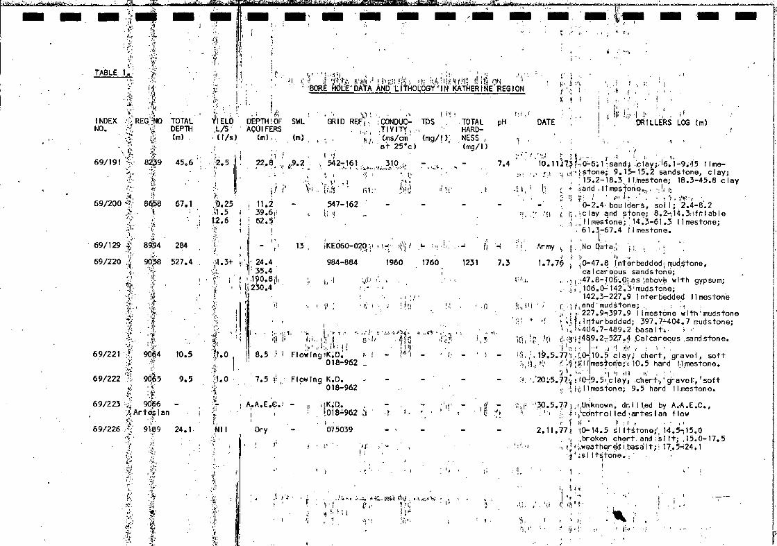
I. TABLE 1. BORE HOLE DATA LITHOLOGY IN KATHERINE REGION.
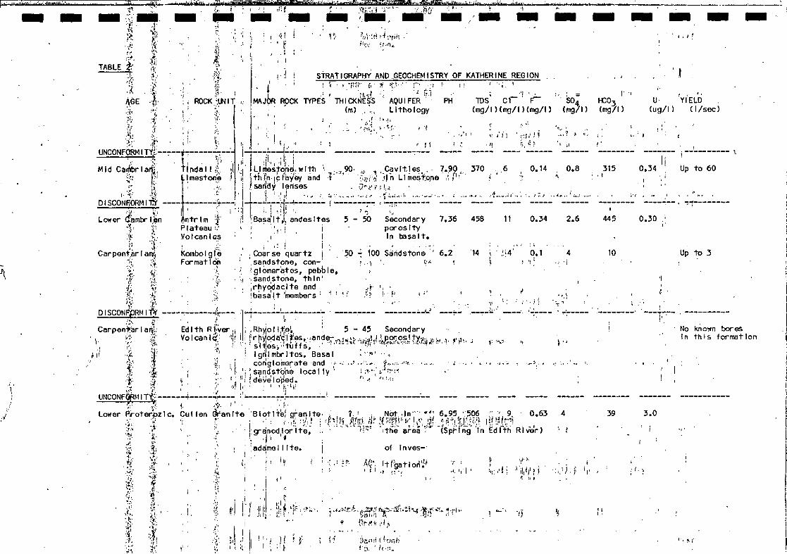
TABLE 2. STRATIGRAPHY AND GEOCHEMISTRY OF KATHERINE
I REGION.
TABLE • I 3. •. KATHERINE GROUNDWATER INVESTIGATION ANALYSES IN mg/l.
I TABLE 4. KATHERINE GROUNDWATER.INVESTIGATION ANALYSES IN nleq/L
i . .-- ..
... •
1
..
1 . .• . . . I
'I ,•. ... .. . 3
.

LiST OF FIGURES
II FIG 1. LOCATION MAP
FIG 2. 1:100 000 KATHERINE REGIONAL GEOLOGY
I FIG 3. 1:100 000 LOCATION OF BORES IN KATHERINE INVESTIGATION AREA
I FIG 4. 1:100 000 SPRINGVALE BEDS ISOPACES
FIG 5 1:100 000 JINDUCKIN FORMATION ISOPACHS
1 1 FIG 6. 1:100 000 GROUNDWATER INVESTIGATION AREAS
FIG 7. 1:100 000 KATHERINE RIVER ALLUVIUM
I INVESTIGATiON
FIG 8. KATHERINE RIVER GEOLOGICAL CROSS SECTION
I FIG 9. 1:100 000 LEIGHT - TWO MILE CREEK GEOLOGY
I . FIG
.
10. .
LEIGHT - TWO MILE CREEK GEOLOGICAL CROSS SECTION
FIG 11. • 1:100 000 McADDENS CREEK GEOLOGY
I FIG 12. TRILINEAR DIAGRAM - CHEMICAL CHARACTERISTICS OF WATERS.
:1
.1 . .
..... .;... ....... .'.
I I -
'1 .. . .

1. INTRODUCTION
• This report studies indtai1t.h.rea defined within a 15km radius of Katherine for,potential water borefields to supply the town.

- - _L.-- ---- .--.----.------.--,---
I 2. CONCLUSIONS
within the defined area there are no aquifer systems I I. tobe found that are capable of producing sufficient quantities of low hardness groundwater to supply
I Katherine township.
2. The Tindal Limestone aquifer system offers the only -
I .
. groundwater source capable of supplying the town.
3. A policy of aquifer protection requires drafting and enforcement to maintain the integrity of the existing -
I aquifers' water quality.
I I - ..
H -f- i
•_i_.
-. .
1: ::.:: :1T:i iT 1 ...• - .
I . ..- . 2 -

I 3. PURPOSE OF INVESTIGATION
This report presents a geologic assessment of potential water borefields to supply, Katherine township.
Requirements for a water supply to the Katherine townsh-i- are: a) Calculations indicate that 10 megalitres per day are
1' required.
• b) The'-water-has to be of low-hardness. -
c) For economic reasons, the water supply should be loca- ted close to the Katherine township and accessible,
I during all seasons,by road.
I •- . . . ..
.,
I. H - -
Ii
i .. -

I 4. DESCRIPTION OF AREA
4.1 Location and history -
:I Katherine is located about 320 km southeast of Darwin (Fig 1). ..:The...town of Katherine is-s-ituated on the Katheriffè --River, at a junction point of the traditional country of
----- -----two- Abor±gFna1 tribes (the Djauan, the Wadamsu -. the Djauans-----are still represented' in the area
The 'firstEürôpeans to region Ludwig Leichhardt in 1844 followed by Augustus Charles Gregory (-1855), John McDougall-Stuart (1862) and Daid Lindsay - (--1883). The river was -mamed on the 4 July 1882by-'--' Stuärt-after a daughter of- South - Australian pastoralist, James Chambers, who sponsored three of Stuart's journeys into the Territory.
ie The area investigated is on the northeast margin of the Daly River Basin.
4.2 Geomorphology and Climate:
The area investigated is comprised of gently undulating
terrainwith occasional minor elevated plateau remnants
• and jagged limestone ridges and sinkholes typical of Karst topography. To the north and east the oldest basement rock, capped by younger, sub-horizontal sandstone, forms rough ridges, steep valleys and plateau country.
The westward flowing Katherine river with well developed alluvium levees, forms the main drainage feature. Mixed open forest, tall annual sorghum grass and pandanus and paperbark trees flanking drainage channels characterise the vegetation of the area.
With a.tropical inland climate showing a narrow diurnal temperature range, distinct summer wet and winter dry seasons divide the year with temperature, humidity and rainfall increasing during the November to April wet season. - Average annual rainfall is 950 mm.
-- ---------------- - --- --------- - -- - ------- -- -- - ---------- --- ----- -- ------ ------ - i.
4- •4 •.4 _-t 1, - -. .1 3 — -. - 44 - -, - -4 - '- .-- 4 '-'4 , 1,• -A - 4 a
I -
I .,.

T M C R S A R AFUR J/ S E
DAR'iN
I ) -
/ (
< ATI-RINE
I I
tA ( I
/
NORTHERN \ TERRITORY
I
SA RKLY
PENNANT ICREEK
C
Iii
ALICE
SOUTH 4USTRLIA - -
LOCAON_PLAN FIG I

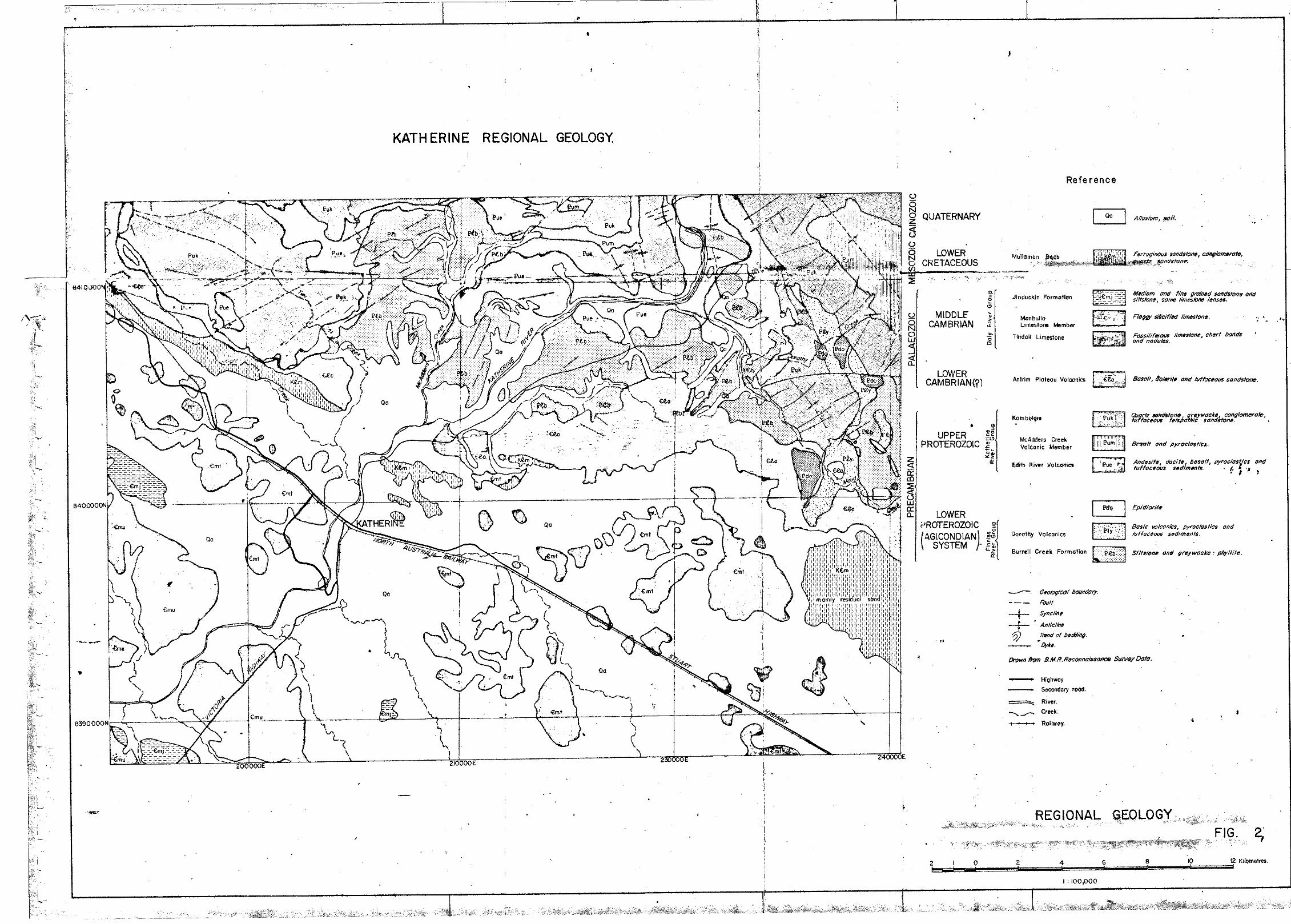
5. REGIONAL GEOLOGY
The .:.first broad reconnaissance of geology of the Daly -R-iver--area was described by Woilnough in 1912.-Noakes, WalpoIe Rárdal and others workëTd in the area betweenl950
- - -
and 1968. The geologyof Katherine 1:250 000 sheet was comp i-led-- -i-n-. 1962 -
. inV.e.§t-.,i7gatioYi has been und.tã W:thth is :.ae , thé-hn some reconnaissance work (1976) by W.R.B. on groundwater oteritfa1s -
- - .- ---
ii
F -I ii
. - Th:in st-igation area Iss -ttuated-onthe nortneasTtmargin - - ofthe-DalyRier Basin -
-
bcks teféã äf Burre1l Creek Formation of Ldwer Proterozoic, metamor-phosed and intruded by a multiple batholith, the Cullen
......... the close of was up.iifLtedand eroded before the extrusion of a thin pile of acid to intermediate Edith River Volcanics of the
-. -. order pf- 50 metres thick. The fluviatile Kombolgie Forma-tion of Carpentarian age was derived from a provenance to th theat- and. deposi-bed d- nforbiab1y.ôn1 a i-r-r-ü4r----
.-MIA1.aidëan -fo-11ow5:by a long petid bffië - e-xtr-usion-of- the.- Ant.r.-im_.P.ia.-tea.u..-VoicaniCs:(.p:1.ateau --ba-s alts) áf Lower Cambrian age. The Daly River Group, con-
• - -- . - of ..Cambro-O.rdoiian-age ---wasder-iVéd ;from nerded- basement hinte-r•-lndo -cend- -depos--itedin
harbasin
El Anotherlbng period of nbn-deoitidh ensued before the Mullaman Beds were deposited in the Lower Cretaceous on a near- -f.-lá-t-- surface. ...- .......... .. - ::; -
Areconnaissance geology-map at- asca-1e of 1:100 000 was - drawn r.based on B.M.R. 1" : 1. itemapping, and surface traverses for this report--(-F-i-g---2.) were run throuq-h areas.--of maximum outcrop, both in high relief and in negative relief areas along Katherine River, McAddens Creek, Two Mile Creek and Leight Creek.
I I •- .-
,' - -. - -. - -
- 1• -
I I
5.

i-I 11 L
N'
.-a .
6. PRE-STIJDY GROUNDWATER DATA
Study of the limited information available clearly mdi-- - ••-ca-tesTi-ndal' 'Limestone as t-he:most productive aquifer;:
Water ; emt' data suggests negl-igible gro.undwater. - - interchange--between the .imestone ana-eltrier tne voicani-cs. --•. -or-the Jinduckin Formation. Piezometric data shows a west- - southwest rnigrationof..Ti.ndal..Lirnestone. groundwater--east of theKa'the-rine River,--while...to the west of the::-rivr migration is east-southeast. -
6.1 Existing Bores and Their Aquifers: --.---........................... . •--'-:
Croundwater is known., to be available throughout the are'a::.-at varying depths from aquifers ranging in age from Pre- c-ambr-i-an.......to.-.:Quaternary,';4'Ta'b'le-----2-).' There is ai"-mark ed--varia-t-i-on- -irrthe : biky:.Qf. groundwa rdpEnd:iJ1gQn rock-- pby. -,.st-rutu're,s. In,f,orniat-j'on:..: on,rna,i:iyof the bpr.sdi'.:e&.4. and around -the.re---s ob.aied mainly from driller.s logs, but -aquiferdep.ths'.
- -a-ndandthg -water level-s ---h-adnot- always 'bee'naccUrateyr - '- - - recorded. Many.Iogs, were with no informio
available for---some-.bores'. Additional informaton - , vas':- - -- ba4npppr of -bore s:F'igure 3 shows the tiaz
of - bores in the investigation area.
the.., area pf.rmd-. - water-..supply--interest. '
Mesozoic and Caiozqic_.- .Mullaman Beds - y; --.A-l-luviurn silts
Ordovician...-.-...... .. ....... .Jinduckin Formation -& -. -, - -• - . . Springvale Beds - -
Lower-Cambrian..............'.'..An:tri.m Plateau Volcanic's - Lower Pxoterozoic .............. Burrell. Creek' Formation
I I
I
- . .--- - 6.2 Bur-r-ell--.c-reek Formation-. -- '-- .
- - The oldest rocks in the Katherine area_outcrop to the
1 - - northwes-t—and- the northeast--of---K-a-t-herine township, these being folded and sheared rocks of the Burrell creek Farina-tion ofLower. Proterozoic age. They are comprise .d,..of..grey.
I .. . ..........................waçlce and sirltstone With sub9rdinat,e sandstone. conglomer-
-..........--- three bores have drawn water from this formation.
Yields are moderate to poor, but the data from so few •
. bores is not sufficient to give a general opinion with -S2.it. il,tty..a5. ..an :.aql ifei, ir gene.raL,,- .th.e
- - Burrell Creek Formation is similar to the Noltenius Forma- ..regarde.d.: .as a. ...
to this formation (Wàlpole et a! 1968). Drilling in Burrell Creek and Noltenius Formations elsewhere in the I . Territory shows the formation to be an aquifer of unpre- dictable potential.
I I
.-. 6

I 6.3 Antrirn Plateau Volcanics
Lower Camb.rian basic lavas and tuffaceous sediments of the unconförmably overlie thProteT-
ozoic rccks: At some places A thin conglomerate horizon - rs- - pfeent attheTnterfce of alluvium and volcanics
- So'iie:drflrthghad already beencarried out in this Volcanic .. 'M emrut:informationfrom bores is sparse. Only a few
- bores had penetratedthevolcanics, giving low yields from
.r •• nil to 2.5 1/sec. The • low yields contrast with better yields obtained elsewhere in the Northern Territory.
t-. .- . - T .- . .: . --- ---------------
------------6.4TindalLimestone -.. . -.-• - .
Bherrajority of bres'have been drilled Tint0
lbwest bed of the Middle Cambrian Daly River Group-1 the - TindILimestone.At 1 4t6re hveEèn driTdió
I th1imestope, with at 1at another six bores intersecttng - Tinda1 Limestone Thtdepth, and possibly others for - which -
-------- thee areno records.Yre1dfrom the Tindal Limestone are I - b'ores, only 131 täid' I les than l 1/sec 1 and only a5% obtained less than 0 9
- l/secOf he remainderyields iary from 1 to 25 l/secr the - iajbiy(58%) haVingyiels ofl to 8 1/sec -
. - rai sof pmpintests, where noted,vary from one hour to hree days: Consequently wftht better construction, weilT
- development and with more detailed pumping tests, better yields.rnay beobtained - -.
I 6.5 SpriiBeds - • . ., ..-. -... :. ThëSpiñg1 Beds, located un{on
.formably aoove the Tindaf
Limestone ofthe Middle Cambrian Epoch, and disconformably
Ti - below Formation of the Ordovician Period,- have lTېd areal distributio. and appear to be confined -- to ttMctroughonthe basi margin, Fig. 4. -
- - ---------TheSp'inaieTBeds are a lensing, deeper water sequence
predomixiatly calcarious shales with a thin limestone 1 horizori, I of the Northrneat Homestead, 10km southwest of Katherine.
-- -. -- Ten investigation holes were-drilled by Water Resources
I -- BâñhhdthesttiarrAton-ic' Energy Commission - AEC ----- - -. Idi 976ard1977; The holesdrilled by AAEC (Ki5 --I
KA7, KA14, KA15 KA17 and KA18) were established as being •- - derived from the same confined aquifer located - at or close
I .
the base of the Springvale Beds. The groundwater in KA18 -.
is artesian. A strong flow of groundwater was encountered in the above mentioned holes at a depth of 7 to 8m; this
4 üd• the I Ve 0,f àTtt ThTurky -Nest Spri Tgto - and reduced the flow from Springvale spring and other holes
-S-pih alHo stad : AAEC reported - I tha't-roundater from these holes was radio-active. The artesian condition
I I •. . -
. 7

I of groundwater is confined to due to local minor faults and
-.. ....-tion,has,.been...done.--
..No.qu.if.er..test wa. • carde yield from the Springvale Beds
only these beds. It may be folds. No detailed investiga-
- ....
o•ut on these holes-a-nd..the-----' is unknown. . -.
-T- - .--•--' 6.6:Jinduck.in..Formation: : ----- - -- - ---------.
:1- - - - The—Jinduckin Formation and its lateral equivalent, the Maribulloo Limestone Member, conformably overlie the Tindal .. T
J .. .- . Limestone and Consist of flaggy, friable ferruginous sand----- - •: Stone and calcareous siltstone with thin limestone and
doiomite interbeds. Units higher in the sequence showa greatersn d content. Chertbarids and nodules are cbnIohiñ t,he .Iime.s.tonand....dolomite:i. ..On-i.y, in, a fe .bors;. i:s : .th:T.-
.QVtJ:YiP : Jipiiick.in'prm:atipn eetra-ted,and yi1.s_,vary....... ............from.l-L/sec-,Xo. 2-i/sec..F-i...5- shows.the
A-sopachs.of. the- Jind-uckin.-Fo-r.mation. - .--. ----- -----..,.--.--- -.- .-t-- ------------------ . •_.•_ .
: 6.7Miamansanc1cauuiozoic' Sediments - 7.
1 The Mullaman Beds, (freshwater and marine -sediments-,sand- - stone and siltstone of Mesozoic-age). unconformably - overlie
I -. ..- ......aLl------the- older -units and are widespread-throughout -----the - region. - They are extensively lateritised and in placés
- . ::reSiStafl.t cappi-nys - of -p1ae-auand mesas -Jnthe Darwin-area bores, drilled-in Mul-laman.Beds.- - .. have created bore development and construction prohie.ms,; -
--------------- particularly development problems because of compacted fth.... material. Small supplies of ground water were encountered during past drilling in Cainozoic sediments. Water supplies-
i - have alsD been obtained from Quaternary alluvial depoS. .4859.,.. d.8.8.)..itua.te.d
between 3to.,8l/sec. in-,-coa,rse •sa.&ndL.-. -- . :qravel,while three other-bores -(RN 5154, 5019 -- ànd5020):;by
- ....- ... .have yields.of_le.ss than..0,.4 1/sec. Lt:±s:; likely -.t•hat.,--for the first thre.e bores, the sand and gravel is greater, and infiltration through the gravel fromthe_n.earby Kathene Rier
......- - yield..------- -The-. --wa-ter. from these-hoies....is -high.- - carbonate .(CaCO3).
-. .6. 8qif.er.Caracteristics
Mest ,pump.ing ••dthe - -wib.. - --- - -. tics and hydraulic parameters--co-uf(f—be-der'ived is Iiitd-
--------•-- -- - --App.roximate-ly---.13% of -bores--dri-l-l-e&-- i-n-the •--i.nves-ti--gation -
I.................- •aay-e -- en test --pumped .Qst tests: were of - short dura- tion (less than eight hours). and poorly documented. In the
• - investigation area, only Tindal Limestone aquifers have bee.ntes•ted---at -T-ind-a1 .-A-irs-t -H4.±--.-4present -. town supply bores) and the alluvials tested at Nott 1 s and
Crossings. Regional transrnissivity has been-eti- - - I
. mated from water level hydrographs of bores at Tindal Air-strip (RN 5329) and Nott's Crossinq (RN 8994). These bores rose in sympathy with flood rise, in the !<atheri-ne River (recorded at High Level Bridge G.S. 814001).
8
I

I 4:1
6.8guifer Characteristics (cont) -
Tindal -Limestone . transmissivity is estimated ti15OI 2/:
- -day arid the Nott's Crossing area aquifer at 27Qmday.
I... . . ..i-i.-1. ...:'.i.::_iI.:.:-. . ....-. ........... ............ ::L:1.. .
.. . .. -. - ... .
.T .
- -.-.,?---%--- -.-- - ----- - -
-...-.--,.,-
.-.:z._.--z--rr-,--,----- -----
..
- - -.. .:. •.. --... ........... . --: .-.--.-
... ... .. ............... .............. .. .-.- .----..:-.
---. -. ........ _r ....... - ....- --- ------------ .. .... ....
- --- -
. ..-... - - .. -
_ I.. C --- r rr r - .
••d - t4 - - - -..--- .- .1 .. - ------- •_--._. _-.-- - ,. . .
- .., --- .
-. - - --- -,---..-• - . ........- . - - - I -. . - t7 -
_.._4.-. .......
- : 4---. . -.-- -.-.
•-- ......- . - . -.
--
:------- - =-:--.:-:-•-:;:::-...... -.---• ... . ----. .... -- - -.--- -_-r_.___...
-: -.: -
. - -:--------"- ...-. --
-
- :-
------- ------- --- - ----------------
- ----. --..- ,- ....."---, ------------, - ------------------.. - ......,-.--.-'-.----'..--.--. ---------
pT
I
I 9

1. 7. GROUNDWATER INVESTIGATION
Given a requirement for low:hardness water, the town - supply borefield cannot be loct :WTijhin the limestone
formations. Field investigation was therefore directed towards the beds north of Katherine. After geologic map studies, three areas were selected for initial considera-tion (Fig 6).
7.1 Areas Selected for Investigation
I .a) The Donkey Camp Area, located upstream of Nott's Cros-sing along the Katherine River. This locality was investigated for possible alluvium filled channels
. associated with earlier courses of the Katherine
I River.
b)Two Mile Creek Area, located 9km northwest of Kather-
I me. It was considered that in this area, fracture zones • within the Kombolgie Sandstone could have yielded an adequate supply of good quality water.
• c) Upper McAddens Creek Area located 15km northwest of Katherine, close to the present stream gauging
I station. The Kombolgie Formation is faulted against the. Edith River Volcanics and Burrell Creek Formation here, and this faulted zone was considered prospec-tive.
I .. S 7.2 Katherine River Alluvium Investigation
Burrell Creek Formation is exposed in the north of this I -
1 area and along the river and creek beds, with Cainozoi sediments superficially covering the remainder. To the
. east and west of the area, Antrim Plateau Volcanics, dipp- ing gently south, overlay the Burrell Creek Formation. The right bank and the left bank of the Katherine River
- I were considered separately.
In order to determine the thickness and composition of the alluvium, auger and rotary percussion drillinqwasc id
— o-ut the Tt Wthe . riTghtan sounding methods were used, and two holes (RN 9192 and RN
- 9212) were drilled. The potential drop ratio method was
I not pursued because during several attempts at various sites there p ét IönTóf. the- underlying material.
ApOssible buried alluvial channel on the right bank selected from aerial photographs was followed up with a
-• ground survey. The seismic and resistivity results and d1cà I f1d Fli il
channel exists in this area. -
•. Geophysical control (RN 9192) - and check (RN 9212) bores were drilled on Traverse A at stations 0200 and 0700 res- pectively. The control bore yielded 3.6 1/s of moderate
- 10

7.2KàtherIriè Rivr1½11uvium InvesEigt1on(cont) -. .......... - . ........
• qualitywater from a vugularzone:..•in the volcanics between • - I.5.4m.and15.8rn.. - ..
_&S4b4-1 a1 C-o the Katherine River producing adequate watr to supply the town was investigated by determining the thickness of
- a111-uvi•um and . the production -rate. and chemistry of water froiaucjef ai drill höIé Rëbññaissance 9e6iogical -mappingwas conducted, and- ._f.ive.-.auger --hole,s.--.and----th.ree rotary:holes were drilled. Water was encountered in only
- three of-the auger holes. Each±0f -the rotary- dri1l.holes L
1 . . inter-sec-ted--a thin veteer--•-of....weat-hered-basalt an.d----under-
lying -urrell Creek Formation -Fig 9 & 10). 1
- •. - -. - •. - 7.3 .Leigh.t. Two MileCr.eek Ar.ea. - ••---• -
I - - .•-. ---olLowg a- brief reconn-i- -
- . -- Qib1 14 areas designated "Area A" and "Area B" were studied in
• -I • --
.---- - d e ta•i-1-.--- - • . . r- - .•,•,_-- - ,. -
- ..ti __:•-•--. --'.•• •- -• -. •.-• • - - fl ._•_- - -•-- - - -- . .• - - •, -
........ ............... - It- was:reasone.d.that...i.n...the woM4-le-Creek. Area-.fau-l-t-s—ad-'-- ..fr:ac.t..u.r.es:, .w.ithin--the•--I<o•mb.o-1gie -- -F•mat-o----ei- d.---bave
yrie.ea.&eqMae. suppi Agep.hy. -xv.ey • - wasplanned to locate these 'fauits and fractures, and-the
I- - geophysical traverse lines were sited on what was thought to be--Kornbo-igie mappi-ng- -and
-
-, s-it-ed --Mu-1larnan-Bed--
-- - was- si ppwan openas.u,rrQd:by
.' - .- - - .• --
t-he•-KornboLg-i-an.stqne --Fo-r-mat-ier-----b.ut - - - subsequent drilling revealedthis-open area as a windo------
structure-. upon the under1ying Edith. River. Volcanics.. -
Unfortunately. the Edith River Volcani.cs proved to be non- prospective for water, and the geophysical survey shed
-
- :- - • -- --
information of little ya rpg e0.og:i c- y u(
I --- Prior - to-driili-ng-±n--*r-ea---A,- magnetic, appaen.t-tesi--stiV-
----
- seisrn.ic.. ctjpn... surveys were carried out. Mag- s were carrie out-.
magntbmete.:—w4--th an aôc-ey of
-.r
.. . Throughout the. area underlain by the Kombolgie Formation .the magnetic fi-eld was-"fiat" - - and - of- the - "order of 47750
- . gammas -which was the latitude value of the earth's total - - field for the region.
For apparent resistivity the Wenner array was used. MJ
I SOm and 90m.
A large variability in the resistivity existed along the - eastern end of Line A. The resistivity low may have been
I . • -
I • - . • -•
- 11

1. • . __.7.:3. Leig.ht Two Mile CreeJcAre.a. (con . . . .
•iis ocfatéd with fau1tinqô 'àY (ch10rite)i1t - ticinwithin the volcanics . - - ----- -:
I The resistivity profile alOng Line C showed a large varia-over . the Ed i-t-h. r.-rp]ap-i.c.s aid- less-ai.ab i,ty- .
1 - Mullaman • Beds. A _prninexteistivity . low
f1-•-- - .- exJted. ••. •.---• . . . -
•On.Line-D res-istivity lows were--al-so -encountered.:
1 .. -. 17 Dif. f .r
icu.itwasencounteredini.ii]ing--t.he.shot-holes.for - - •
the •se.i-smic-refraction survey --h.Jard -subsurface gr-avel to:.si1i-c,iE led -.caused=exc.essiie-. auger -bit wear; resu -iting in shl-low poles. The effects -'Qf.
- the hard pebble bedrock, the undrlying weathered volcan- - . ics and the shallow holes createdexcessive crossfeed and
but -er-tFe1essresu1-s.we
........................ - - ---- -• -
1 - - Based on the geophysical..survey findings, five anomalies -. were selected for further investiqations. Three rotary
• - . ,boreho1-e.s were: drilled on Lin-eDRW.920.1.), . Line . .................902and Line. A (RN 92Q3)...Mlthre.e holes st.ruck...Edi .-
th: -. -
(. . . .
.. River,.Volcanjcs. .... - -
In L • Area .B two inaietic and esjstivjty
- -, _-.... physica'-1 recormendat1ons.Both-rnagnetictraverse r-e4vea1edr
..-.. .. . - weredel-i-nea-ted.The.---- gçpc edure---fo1 loed re,si S t 1 Y Area-A indicatd_zo.i -ls.i.
i
-. .resi stiv ity .-On Line At zonc-ured t tatiQjiS- -- Ul2d_Q24O and- on- .Line.. .beween sta-tions--Oad.--_—
- -0-25Ar:photograph -;
- . -
i-nd-icated. .tat th r is tyw...occurred on ----- -. - --ent-------l-i-near whi-ch- wa -s- posibl-y---a-_a.-t a—'—
I . -selected- -for--follow-up dr-i4-14ng1 7 --F-ol4-owinq. the geoph.ysical:. and geological survey check, a bore (RN 9204) was located
01p - porpticd.i:R4VInics at 5. Sm and was termin- - ated at LftJinetres. K !qrmation was not_encount-
- •I - -----------. e-red •. ........•. --------------
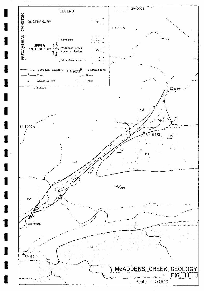
- - -M •_ t -. - . / - .4 NcAddens Creek Area.- • - - - - -
I .- The major faultin theMcAddensCreek_area downthrew, Kom-- bolgie Formation agafnst EdithRier Volcanics and Burrell
Creek Formation to the west. p4:--1.c.-•,c. i'-:.. ' - c_---- ••'.':; .. - . - Superficial sediments are limited to the area close to the
• programmed for this area. Instead, two bores weresiteddn
I 12
I

I - : the east side of the major fault to intersect the
-- KOmboIgeForma t iop t -
- - 1ocatedin.4the - upper.part of__
L : ,R.o.rmatQn, whilst the southern:si-tewas located at the top
. . - ofthelawer part ofthethrmation. The bore (RN 9213)
drilled at the northern side intersected a sequence of
. . pQO.r1y -.
. si1tte iielding only minOr amounts of water. This bore - -• WSCP eted • -a-t-•-- -1Om—w-it--supp.-1y '--of
- . - -.
•:: .-- . •
•.•. 1• •.•• ••-- •••-
. •••• - .•-•• :
U • • ... • 9214) -in.raecte frac.tured .., bas1tof :- .-:. • ,. -• he..
: •- - •••-• •into-
-sandstone .• of. ,. •, e: bQre:was •.• • : .COfl at gqqd from fractures in the basalt. The sandstone exhibited
I little fracturing.
• _•-.
wate:r--intersected . in... the-setwo.bores was-j-- associatecLr. .
• .with. a aj.or.. fauit;zone ,.andyat.r qual ity suggests. . - und.er± low ofjlcAdde:ns. Ct k. he.-e.condb.or.e .
- • tested.,because large storage wa:srivi.saged and the--uppiy: did not, appear suitable for a large groundwater scheme.
im
I -- '- ---:: i- -;- - • •
• • . j '•.- ;r •r.2i
U --
-: ------ •-.: - - s---- g -• - - -
--
-I- - --;-----:;. - -- ---- i-:- -
• -- --- -- --• • -.-.---;. ..,..,, -- •. --•--.•
- .. - -- - - - ------ - • - - . -•-.,. - t -
1-: - I• __________
....................................................................................................................................
-...-
• '- •- .- . .. I ' - - ...-., ..-_-." - - - - - .- - - -.
• - • •--. • • • • - -
I •-.
I -., .. - • .
13 .
I I I I I I I 1 1 I I I I I I 1 1 I I I
Z4OOOE LEGEND - - -
C-)
0 .
QUATERNARY N 2
4'4OOCN N o
z/ 4 1 .
- . UPPER
PROTEOZOIC Add8rt Creek
o mber
rlj vc: -
Boundarj pq,slervfi Bre
Fuu,t
Traci(ooq;o p --- . -
23OOE Creek
84iCOOM 7:
Puk
)
/,/ / F--- -
£'ue \. J/14-
- - - - - -
- ----
( 412 YOt '- -<-' - - -fl.--- •-
pvk
- . . . . . U -' •-•----
/
/ I
• . • .
J cADDENSCREEKGEOLOGY
FIGI: .Ti • • Scale OOCO

8. TINDAL LIMESTONE HYDRODYNAMICS
Recharge of the Tindal Limestone - -aquifers is by direct Othèr Uf ôttfibStiOñ. tecfinsigrd-
•. •. f- i-cantqua1it-y..and geochernica1e.f-fects..•
F -The iT950rnrn averae annual rainfa1l-inthe-..Katherine area an&eL.apQtr..a.Ds.pir.at •iQrL•.i.S:esti.Itsat. . ..
I --.........._ ......... . ............. .
- .P ra -Q-directrunoff.---.- - --
'
I infi1 traton.... -. .. .. -. :if.
I=.5P
I : . . . . ..... ....
-
•..-..-.-- .. -----. ---R -r - - -F
- ..Clt% _C*-..C.fr •j:-__.____. .-iS.4 f ..........-c,gr-*- •M_P.4L•. -?-w_C.
-- .w-he-re. -.------ ...................
I E = evapotranspiratiori .R.groundwate,rrecharg. .
-- for I then R= x 950mm/area/year .15 -
1 . For, recharge area of 100 km2
then = .14m x 106 x 102 m3/year
40,000 rn3 /day
= .45 rn/sec
I- Ti --------" -
.'.
.-
I 14
I

1 :1
[I
9. GEO-CHEMISTRY OF GROUNDWATBR
The dissolved substances contained in groundwãt't - Katherine derive ftothtëcöntact with the atmosphere
Ic ,
vegetation, soil and roc-..-In- the investig.ation.area - air-------- ôITLiflöñ is relativeI'Tthiñt 1 so, water oflôw -contamina-
il--surface. Percolato-n-- through -f i'm-a rt-r-apped in
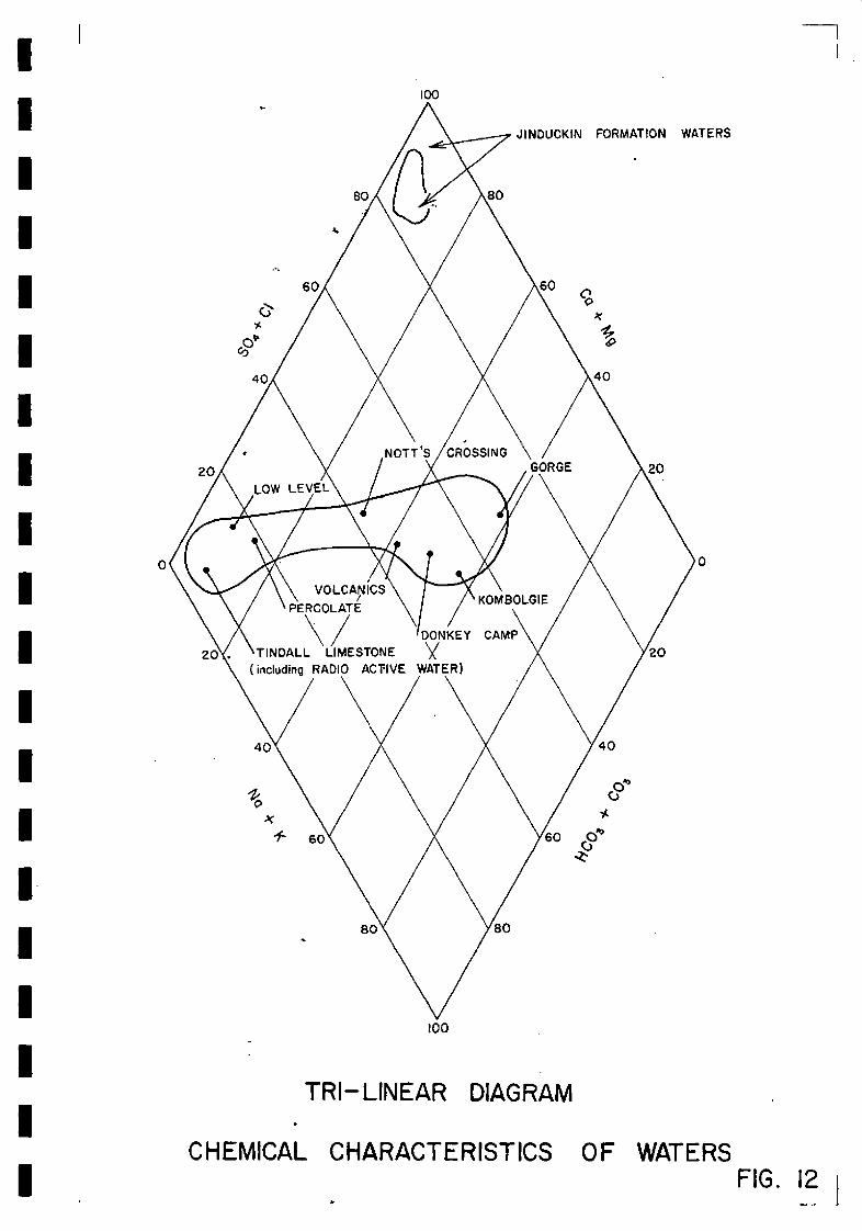
the soil.. Where limestone and calcareous soils occur very close to the surface, carbonation and dissolution begin almost immediately; where no limestone is present, the proce.sses..of weathering proceeds at slower ra-t-e-s-----An-a-lyses of groundwater in the area of investigationwas limited, data being available for -only 56 bores. It is -obvious that more detailed chemical analyses are required for a clear picture of the investigation area (Fig 12)-.
9.1 Geochemistry of Waters
The Katherine investigation area was restricted to the following a!uifers, with -respect to the geochemical chara----cteristics of the water they contained. Analyses of groundwater in the area of investigation was limited. More detailed chemical analyses are required to have a clear
- picture of the investigation area. The chemical analyses .-h-v been. summarised in Table3 and-4. -
I
I I I i..:
I :
i........ ii
1. Aquifers in Kombolgie Sandstone. 2. Aquifers in Volcanics. 3. Aquifers in Jinduckin Formati-on. — 4. Aquifers in Tindal Limestone.
• 5. Aquifers which produce radioactive waters. S .. - (Springvale Beds).
* Table 2 shows the stratigraphy and geochemistry of the area.
Kombolgie (no dominant ions).
Waters -from aquifers in Kombolgie sandstone have low mine-ralisation and in general, no cation or anion is dominant. Frequently, p1-I is low (6.0 — 6.5) and, infrequently, iron concentration exceeds 5 mg/i.
9.3 Volcani.cs
• The few bre in haè water analyses thdi cate a high bicarbonate water similar to. .limestone aquifers. . . .
It is considered, however, that those samples analysed are of the true natur.e.. , of .thewa.ter.
volcanic aquifers. ......................................................
9.4 Jinduàkin Formation (CalciumSu.lphate Bicarbonate).......
f ., 1 rn k I- __ -- —' ,. ,-. 1 -. '.... I I L.L. L L'LI W.L. ItIL C4 I.. -I II %_ i. LILI , QII.A tl I. 11
T.D.S. distinguish Jinduckin formation groundwater from
U 15
I
I I I I I I I I I I I I I I I I I 1
TERS
'liE
TRI-LINEAR DIAGRAM I
CHEMICAL CHARACTERISTICS OF WATERS I
FIG. 12
9.4 Jinduckin Formation (Calcium Sulphate Bicarbonate) (cont)
1 Tinda1.Lirnestone groundwater. Iron concentrations vary tup .... .to 7.7 .rng/.l, (boreRN. 6&80)_ and a.rdness, as .CaCO3 1 is
1.600 mg/i......... .i- -.-
I - - , . .., .- .. .. ..-. -- --- ..t. .rnr ,'fl r. .- . - ••_ _•__ . -. .--. -
T ind a 1- t-e*e.L&-r 3-hrdri-e as as -its ............... .......dominant.. featu.re.-It- is---notedt-hatother--elemen.ts - are-- in - ...........minor .quan.tities, indicating rpia.-:.infi1tra-ion- to the..-..
. - . rsampies. f r..2301fl-..of-confininq matjl -Bore.r RN- 9058).give- - al-most ... idntica1 analysis rasults as Water from the same-aqui.frer
-. a rine-, ..-. .. &-- -C-iu t tat ta-C vesin te4rrns.of--bicarbonate and .-hardness -The degree of m-inera1:i-
- zation increases south-westward, the flow direction.
9 . 6 pYihIBë(CT15ium 61uiiBicarbonaté) - .........-.
L -j-;-
-S..
I Stations nd-west-sout-hwestfKatherine.- The-waters -are
- cna.te t-ype wi1P. an.d..the..posi - :
-- . analyses .plo.ttd.::.ori..: a_ trilinear.-:diaq,ram.
• -- an ... ium 226 contaminati,on..recorded was 216
. pCi/litre in a sample from Turkey's Nest Spring.
• . . . -.._. .. - ;.t :.L
•r . ..4
. + -. . •
- ;• ..•.. ,_;- ...... 1
- - -
-: - .-- . --- = ------
::----
in
I I
4. - •• .4. t •1 4 I -, 'L. - •- - .. - - - •- - .- - - - - .- - - .-•;-
•.. . .-• - . . 16 . .

I I. I I I I..
.z
4
I - 10 I.NFLUECE OF GROUNDWATER RIVER WATER CHEMISTRY.
Immediatelythe e Katherin River passes over the Tindai Formation (between Notts Crossing and McAdden's
Creek) the chemical nature of its water changes from a
-- - - to•a
-
water matching that of the Tindal Limestpne aquifer. An - . non-arb-ontohardress 0cc urs btweerf Kathêr-
• --- heGtgé atidft:he -hi'gh1 ieDbidge;This ......- - -•.• hardness -afte the hih'.......
•: Leve-l-sif hardness between Donkey Camp and the .iow leVel - .......-b.ri.dge.ar deper1dentoftr+erhe-i-ght -.- --At -flood -tim
atthe -.---••--,- . '•:•-"-• .--- -.-.•• .•.- ••-- .- --------. -.4-;. --:
- It follows then that much of the flow in the _river at ............... .f.rdii .liDTcar
chemical analyses indicates that this is from Tindal Lime-3 --tone Also,at times off1ood theriver should ehae
r€s:: and 61of'
-_ - r±verheight. -. -The initia16ffët - flooding wi--ir e a. r.egional rise in potentiometr-ic head -in
- - the'aqu-ifer -.--- - -..
- - - -- • . - • The i-nf].uence. o -f:s.ulphate from. rinduckinformation water
beginsabout 10km downstream from Katherine township.
JA
I "I ......................................................................
I .•- 17

I - .
RADIOACTIVE WATERS AT SPRINGVALE AND LILLYVALIE STATIONS
j The springs at Sprinva1e and Lillyvale Stations.derive - I f tieirater- -brn a stratir1ica11y confined aquifr in
- the Sptigvai Bds (ManbiilloO Limestone £4ember). CheicäY
watê sho them to be dert7ed frpn aui.fers . ssbciated iitf -Tfñdà1 mestone The ràdóãc' iiEj rs attributed to higher uranium itheLo-wersha1es_of_ th pi,ingvale Beds Formion- The source ai oris
- water is consderedt 'balong strke ere spot hei wh ht - detei-m.inations from aerial photographs show higher ground • .:- (outcropping Tindal Limestone to the northwest) consistent.
.with artesian heads in bores near the sprthgs. The water - - - mp1e data indicats ti&t the iter that (t
u'reysN'eqtest and Sbrivalesprigs andwhihwastapped byAPECaiger holes h ndt •travelled through the Jinduckin Formation. Field observation sugests that ............-.-- :;z.. - - --.- t-,-rc..r...
t
---..r -_- t_..J_, - -_--..-- - -'.. V? •-- - -. - . r --- r
Pin5al--trimesoie is an open - aguifer system with a Jowe firufT he tha f]TeWtem Thedingthe spring
- ..-' - _.. - •--:..- - - -5 -.------- - - , ..
-
- •--=.._---...- • -- . ------ .....- • ).,.
-. --- - .•. ........- -- -.-.-. - -- . * -
-:' .-;" -. .•- ... . -• -, -, -- - - -aa* .-*.__ -, . - -.•. ..........................
- . .
I
-
i-
I - - • -•
. -. --. . .. . . •. . -• . .. -....... - -
..-*4z?.t: . •-:: .- •;
I I
.18

I _12REFENCES
I . . Háze1,.CPT 1975: -oundwar-H-ydrau1is -Lectures
- - - -
- Preented-tothe Austral -i-.-rz ik. - -
I -- -
- Gr-ound.3a t - -- - -
- -Ade1i-1957_
-
76k6ky,:J,1950 Exp1rationGeophysics..Los Ange1es.--
- QureshrH., 1975 Pre11mLñary Hydrogeological Report or,
I - ber— .
- - ---- ---.----
- - -- • -
1967 Katherine N.T , 12 250 000 Ceo-logical--- I - - Series Explanatory Notes -'
• •-. S-tdy aP.d
CheTnical-Ctiar-acterlstics of-Natural -
Wate-rs!; W e_:S.up1yPa r1-4-73...
HI
Walpole, et.ai.,1968:Geology of Katherine, Darwin Region, Northern Territory. Bulletin 82, Vol.
-
1, Bureau of r4ineral Resources, Geology and Geophysics, Canberra.
I,
-I
I- I . 1.•
I
I .- - ;. ,- T 4 • •-,.- '-.. • -. -, - _- -, -. .- '- - - i. t
I
I Li
19

- - - -
- - - - -- - -
- - -
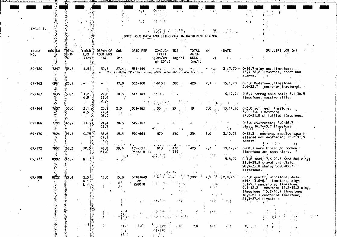
TABLE1 .
INDEX EG NÔ TOTAL-- . Th YIELD DEP OF SWL NO. :.-.: DEPTH 1/S AQUIFERS
• Cm) - (I/s) (r) Cm) ,'
BORE HOLE DATA AND LITHOLOGY IN KATHERINE REGION
(lD REF )NDUC- 105 TOTAL PH,. DATE • DR1LLERSLO' (m). TIVITY HARD-
. • 1 -
(ms/cm (mg/I ) NESS •.-•• at 25'c) (mg/i)
• 1 --I 7 69/3 148) 19.8 1.8 - 13.7 562-157 - -
- - .. TtndaU22 C
69/4 r 150 '
35.0 2.1 16.4 15.5 548-164 - - - - 17.9.43 0-4.2 Sand II
30 5 4.2-15.8 c ay and timestone rubble I 15 8-18.3 Imestone aieI some
1 chert. • c.- 18.3-20.4 mo gavet quartz
20 4-22 8 jebbles and I vnestone 22.8-31.1 Sandstone.
I 31 3-35 2 sandy tlmosto e
69/6 159.' 35.0 . 2.2 7.6 - 544-165 - - -,., - I
: .- 06.1 sandstone 61-19 8 sandstone and rowr' clay 19 8-27 4 lImestone 27.4-30.5 1 imestone
I 30 5-32 3 shale and cia 32.3-35.0 lImestone
69/8 -312 28.3 - 0.5 Flowing 542-159 Limestone Artesian - - •
69/10 325 62.8 O. 54.9 18.3 539-155 - - - - - N6 Data Ir
57.9 594
.
- - 62,8 ' . . .
69/13 '406 20.7 112 15.1 563162 2700 1474 685 7.82 - . No Data
69/14 '409 21.3 1,2 - 13.1 561-159 - - - - - No Data ? :-
69/16 -596i 36.6. 9() . - 21.3 .. 548-166 - 59 6 - 21.11.52 0-7.6 surface soil 7.6-10.6 limestone boulders
• . .- . '• 10.6-18.6 porous limestone
' -- - 18-6.36.6 lImestone' 1 4- ... -
69/21 •
134 Little infmation - except Ma,butioo - 290 286 7.5 -
,.: 1
No Data 11 " Chemical Arelysls Well . L •- -
.': , • Homestead
¶ - Supply. .
Ai
t 4_•.•
: •'; '. . :-
4" -

i'
- - - - - - - - - - - : - -
'. .
:
'1 ORE.H0LE, DATA AND LITHOLOGY INI KATHERINE REGION - ...__. -,:... - I I .... INDEX •EG'N0 •TO'TAL Y1 ELf DEPTh OF SWL GUD REF CONDUC- IDS IOTAL p1-1 DATEJ : OFILLERS 1013 (n) NO. ' DEPTh L/S AQUIFERS TIVITY HARD-
(iii) (I! ) (rn). (m) (rns/ap. (rng/t) NESS at25)
:f.. . ,... . 69/22 ..' 1442 - 305 . -. - .551-169 No Dta
1443 63 7.5 ' : 15.6 - 610 60 340 7.0 -
.
No Data
69/ i 1444 61 0 1.8 No Data -
69/27 t'.
1447 .-.
35.3 2.1 16.4 .
15.5 551-169 - - - . ..
- - , , ........
No Data
:k, •. . .30.5
69/26 1440 25. 0 1,9 - - 51-169 - 667 398 7.7 - No Data
69/5$ 1827 43 7 . 1 1.6 - - 538-175 - - - - 0-274 latertsod sandstone and I salOs
2A1 4 2 30 5 'Sand ston 5J4S.71 Basi+ ,O Jo
69/ 1343 -
NH (
- - 542-158 - - - - - No Data I I'
- ,, 69/5 .. 1439 33.6: - 546-159 740 • N.O. 430 7.7 - No Data
69/57 .•
1441 2765 L
5,0 - rf
- - .
- - -
. - - No Data
69/ 1449. : 1.3' : ,.. 1
, .i547-I63', .... ,... .. - - - - , No Data - ., ........... .. . .
69/5 3908 654 - 312 - - No Data
69/6 3909 33.2 - - 15.2 548-163 643 - 330 7.0 No Data
69/1 t •. 3027 4.2 - - 1p
- 560-159 700 420 416 6.8 18.8.62 . 0-1.2 clay & Ironstone 1.2-4.2 hard limestone
3025 12.2,f 623 ,, - 345 - 17 8 62 072.1 5011 Zk
I I I U. 2 1-6 7 limestone 6.7-7.9 limestone
..-.. 7.9-12.2 1 Itnestone
69/3 1j 3026 11.5 - , i ; - i; .562-l59 363 428. - i1 17.8.62 0-1.2 clay '.
1.2-6.7 lImestone '1 67-10 3 clay and lImestone
10.3-11.5 I Irnestone
69/T4 2946j 24.0 2.0 3.Ovl 16.0 2-164 - - - - 19.5162 No Data -
,I..,
. •;#.. V.-. . . . l.,.JL,.I

- ... -••c ., . .
-
ir
TABLE1 *i
. •: BORE HOLEDATAANDUITHOLOGY IN KATHERINE REGION
•1 -
INDEX REG M3:TOTAL - YIELD DEPTHOF SWL GRID REF CONDIJC- 105 ' TOTAL p)-1 DATE tJRlLLERS NO, .DEPTR L/S AQWFERS TIVITY HARD- I!
ii .m (m) (ms/cm (mg/I) NESS at 25 °0 (mg/I) :
69/75 2902: 59.. 243 -58 52.7 536-176 563 331 333 -
7.4 9/61
i
0-2.1qravet 2.l-4, clay 4.9-7.6 llmesftne, 7.6-7.9 clay
' - 1•. 7.9-20.7 llmeone
i I 20.7-21.4 lirt4i-one 21.4121.5 sand 21.5-429.3 lImestone
- .. bands and ga3l
V 29.3-31.1 sand 1 and -avaI,. 31.1-35.4 cIay
. . 35.4-50.6 llmG5tone, 50.6-51.2 sand clay. -
W 51 2-5.5 11n tone, -. - 55.5-56 clay aid lIrneston.
56.1-59.2 clay, mud.
69/76 2522.: 46. .:
31.5 :19.2 16.4 554-165 •I?
729 450 464 - Surrnary: 0-5.7 clay - 5.7-2 .6 It limestone
69/78 •':
4143;.
.
43.0
I
3.0 36.9 17.0. 562-159 623 -
.
345 7.3 16.11.63 0-1.5 clay: J.-4.2 clay,la erlte 41 4 and tlmeston j4 2-4 5 clay and
I I
1 limestone, 4*7.0 Ilmeston and clay, 7 0-9 I 11rneston4,i 9 -10 6
i. 11 calcareous caV, arid lmest ne, 1 Y 10 6-13 7 11melione, cIcar bus
l 1 II It ll clay,13 7-18 3 1 (at 17 , hard chert band), llmestoe and calcareous clay
V I I 18 3-22 8 calcroous clay 1 limestone, 22.8-32.6 chert, rnalntly In cabcar-
• : . . eous clay and .layey limestone;
I
32 6-43.0 no Stmp lea
• tit : . . .
I
p I
I I
al .1
-
.
Zel
• •. ••. r. . - -.
II Jt

:i ?IELD :DEPN OF SWI. miD REF NDUG- TDS •1 T0Th1 1/S.; AQUIFERS ' TIVITY
.(ms/cm (mg/I) NESS at 25'c) (mg/I)
6.0 19.5 17.0 562-159 700 ' 360 368 ...........
0.03 24.75 12.7 555-165 700 430 436
O.3j. 28.0 14.9 553-164 - C.S.LR.0. 0.4 41.1
• 5.6 15.2 18.2 553-164
• 36.9 •
• O.2T 26.8 18.5 556-164 729 453 453 .0.64 1 31.7
• 3.0 37.8
1.6. 28.6 11.5 549-165 660 568 217
• i.
:
TABLE I .
INDEX Rth NO 1OTAL NO. • DEP'1H
•: (m)
69/79 '4077 32.6
69/80 278 30.5
69/82 '4262 55.5
. J
:. •4
69/83 420 ( 36,9
• •• •
69/84 •, .523-t39,0
A 69/86 ..4525 31.7
& •
3?
3
BORE i40ILE DATA 1AND LITH0L0GYiN 'KATlERlNEREGION
pH DATE • DRI LERS LC3 (m)
7.0 4,, 20.9.63 . No Pate l
7.3 - •' 7 0-313 i< l ca I condules 1.
:4 30-13. massIve limestone C 13.7-7.4 daicaretus shale;
274-65, basalt possFblelinestone interbe4dlrg to 38.1
- 9.4,64 0-2.4 top- sc'l I; 1 2.4-33 sandstone
3.3-6.7 clay and sandstone; 6.7-7.3 dolomite; 7.3-7.9 cIa)'; 7.9-8.5 Ilmostone and clay; 85-10.3 clay and llmestone;10.3-14.3 dolomite and clay; 14.3-15.5 clay and lImestone; 15.5-268 sandstone and clay 26.8-28 6 Umetone; .28.6-42.7 ilmesto e bastt and quartz; 427-51 5 sandtone basalt and quartz; 51.5-5.5 clay, ad shale.
- ' 24.11.60. 0-5.4s 11; 5.4710.9.5011;. 10.9-26.2 • •: - c Vay raldc goll; 26-36.9 clay and
I1rndsto e.. q,l •. f; • I- ...
7.51 0-15 S 11 H 1.5410.clay1carbonate nbdulés llistone 10J6-39.041mes.tone6,
8,14 .16.9.64 0-0.6 clay with travortino, 06-317 lImestone, sbmetlmes mass I ye.-
- • E
-
••(, •F
; • •

--
TABLE .i., -- .. -
INDEX REdr TOTAL .':)'ELD NO. DEPTh : L/S
Cm) (Its)
69/88 4379 122.3 0 03
69/89.", 48 24.4 i;1'2.0
•: . 6.
69/90 4600 46.3 2.2
J.
e.
69/91 4709 31.7 2.2
T . 9/92 r; 9.1 '4.2
J ,4
.-..,
.:• ....
•:
69/93 4881 34.7' ,.1.2
-'1
- - - .- - - ,,- - - ;_! y,'• -' - -
-ti
I
BORE HOLE DATA AND LITHOLOGY IN KATHERINEREGION • I -
I I.
I •
PTh OF SWL GRID REF. .(X)NDUC- 105 TOTAL pH . DATE •' I : 'DRtLLES[CG (m) III FERS TIVITY ' HARD- (m) (m) (ms/cm.,. (mg/I) NESS . 1
at 25 °0 (mg/I) 9 • . I,
ll.7j 50.3 1535-175 - - '.iJ3664C 0-9.T sand, clay; 91r 119 . 8 stone wIth cIay, 19 8-30 5 c1careoUs1 shale; 30.5-39.7
. . Iimstohd,Isa'rtd; 139.7-41.2 ,, I '.I ,. •.'.
aI ltUccareous shaie; 4I.2-12.3 maS5lVe tin I ';1•' I
• -. . .-II'l •.l.
18.3 16.7 562-159 741 408 - .6.86 . 7.1.65 0-0.9 soIl, 0.9-9.7 lImestone; .9.7-16.7 brown limestone;
16.7- 18.9 clay; .18.9-20.7 sand5tone; 2O.:7-24'.4i1Imestóho
20.7 16.7 562-159 779 428 406 6.96 24.11.64. 0-1.5 soIl; 1.5-4.5 sandy loam; 4.5-7.0 llmestone,7.0713.7 limestone and boulders; 13.7-20.4 cloy; 20.4-22.2 Uirnestorte (first supply water); 22.2-46.3 lImestone
20.1 17.0 562-159' - , 518 322 6.91 19.1.65 0-0.9 sol l; 0.9-21.3 I Irnstone; • .. 21.3-21.9 clay, 21.9-28.6 limestone;
28-.6-29.5 clay; 29.5-31.7 lImestone.
•, 3.0 ' 2.1 550-169 470 ' 720 250 7.8 8.5.65' 0-3.0 cIaypebbIe 1 3.'O-6.1 gravel- • . .
. quart pebbles 'frajtient aterite, 1 1 ,!' ••• P iI ? ; 1Jartz5and5tOne, 41mestone, shale,
- si ttstbno,' 6. 1-7.,6 jraveI, sandstone, cloy stc -te, sandstone 7.6-9.1 as above ar g- eywacke.
-i, 4 -.'- •, 18.9 13.4 5438-163 . 660 365 388 7.12 13.5.65 ! 0-2.4 6Il,s.4-3.0 gravel; 3.0-34.7
26.8 'th i •- lImestone with small cavities 30.4 , 21.9 ' • . • ' p I
• :.
1 j . C ,
. . .
it • -
- .-
.1 :. '. t:•:
I . ... •
• - ILII-I. I
- .
• k. . - t ! : • -
HIIi 13 I :
I t i ,- ' . , •.

- - - - U .. ,.;
TABLE 1..
- - - - - - - - .- - -
. :
1EG NO TOTAL
Cm)
1491B
10.9
:.8086
5019 8.8
44
5020 4,5
50421 45
)5155: 7,6
6.1
5h1 28.6
35.6 j.
;. . -
INDEX NO.
59/95
69/98
69/100
59/101
69/103
69/108
69/109
69/110
69/111
BORE H0LE bATA AND LITHOLOGY'IN IAThER INE REGION :
YIE1) DEPTH OF SWL
•
(1D REF CONDUC-
-
TOS TOTAL p4-1 DATE DRILLERS LOG tm), •, LI'S 'AQUIFERS - T1VITY- F!ARD- . .
(in) (m) ' (ms/cm (mg/I) NESS -. . .
at 25°c) (mg/I) - •. .
11'i
- I
10.9..
•
3.0. 550-169.. - - 22.5.65 No Data -• .
• -: 30
126 18.3 18.3 IO20-953 590 350 311 8,2 6.2.72 O-15.34an 15.3-27.4 sends'tone quart4 27.4-35.6 sandstone, 51 It- stone, urt.i,
NI I 3.0 -
Y?.' 553-1'ii - - - - - ' - . 6,965 f, -:0-4,5 sand sam'e]pelbte5;. 4.5-5.1 . . . . sand as above; 5.1.8 .8 sandstone
(greywcke, quart and rithic • - - • . - . ' fragments
.
Ly . 553-171 - - - - 9.9.65 0-2.1 sand, qua'rtz4so, some lithic, - 2.7-4.5 sandstone (groywacke)
2.3 23.2 3.28 439-172 - - - . -. 28.9.65 0-1.2 sand sal i; • 40.9 . . . . . 1.2-16.2 si It5tone, shale claystone;
45.1 . . 16.2-22.6 sand,. quartz 22.6-23.8 cavity. 23.8-32.0cIay; 32.0-39.7
-"r • limestone, cherrt, si litstono to • -',. sandstone; 39.*45.8.11mestOrie,
- cavities from 43.3 1
2,7 2.7 552-171 - . - - - 4.11,65 0-3.0 sand 3.0-7.6 gravel, some slltstono and
• . . - sandstone, very hard.
0.4 2.4 2.4 552-171 - - - - 9.11.65 0-0.6 sand and .aveI; 0.6-5.1 sand • , 1-- 1 and fIne g-avel;5.1-6.1 ay -
chert at total dpth.
- 17.3 10.6 554-170 - - . - 8.11,65 0 - 1,5 alluvIum. 18.3 1.5-28.6m Antrim Plateau VoInlcs.
6. 18.3-24,417.9 562-159 700.' •418 444 1.2 14.2.66 0-21.3 11mestone; 21.3-34.4 lIme- 29.8-34.1 •. ., - stone, crystal 1 lite; 34.4-35.6 lime-
-. . ••,. stone, fragmetsin caicareous clay - . . strati.; LI
• . '
I I I

-
TABLE 1 j i
I 1 j I - BO HOLE DATA AND LITHOLOGY IN KATHERINE REGION
..i. I INDEX I REG NO TOTAL YIELD. DEPTH OF SWL (ID REF (bNDuc- 1DS 1 : TOTAL bAT . bcitt.i S LOG(m). NO. DEPTH 1/S. AQUIFERS 1 TIVITY; I HAD- Ii, '
(m) (/s) (tr) (ms/cm (m/I)!NESS '•') at '25c) (mg/I ) I
69/118 5771 33.5 6.3 '-'32.9 - 562459 750 . 256 'ia - 0-4J5 clay; 4.5-32.6 limestone ': • 32.6-33.5chèrt, sand,, sandstones
I ii mstone. I
• 69/120 5853 30.5 20 . 21,0 16.7 555-163 00 - :90 368 . 7.1 - 0-45 IaterHfIc sol I 31 .' ,' 4.5-30.5 Tindal Limestone
• .69/121 5854 30.5 1t9; 15.2 . 13.1 551-164. 482 282 294 8,05 12.8.67 0-3.0 Top Soil; 2.5 18 1 3 • 3.0-30.5 T!ndal Limestone
69/122 9058 33.5 15.2 0.2 549-155. - - - - 19.9.67 0.6.0 sandstone; '6.0-150 mudstone 15-18.0 limestone; 18.0-30.0 shaly mudstone; 30.0-33.5 lImestone.
69/123 5905 106 0 7 1L5: 97.6 48.6 :535-168 ' 500. . -.' .302 . 7.9,: 23.9.61 0-6.1 sill-stones (calcareous);
•
• 1
• 6.1-106.7 limestone becoming more : 1 •1 interbedded and impure with depth.
69/126 6238 45.7 . 017 . 15.2 14.6 555-161 - - - - - 'broken 0-2.4 clay; 2.4-24.4 lime- T89 ' 41.1 I • .
stone; 24.4-45.7!Ilmestone and 181.9 : 45.7 1 dolomIte.
69/130 6489 6L3 28.7 13.0 543-169 100 - . -. - 13.5.69 0-3.1 clay weathering product • . of lImestone. 3.1-38.1 limestone.
69/130 6670 19.8 265h 19,2 - 568171 800 - 490 6.4 10.8.69 0-1.5 chert; 1.5-19.8 asalt- altered and weathered.
69/134 6662 ' 40. 1 8 • 36.6 24.4 557-167 880 500 494 1.2 6.8 1 69 0-19.8 calcareous shaI,' sandy •
. ( . . :. limestone; 19.8-22.9 sand5tone;
22.9-40.3 basai.tchIor1t:1c.
69/143 6879 45.6 0.4 ' 18.3 18.3 563-169 700 400 342 7.9 4.11.69 0-18.3 basIt; 18.3-21.4 clay 21.4-45,8 IasaIt.
69/144 6884 451 1.8 27 Jl 17.6 552-168 -. - - - 15.12,59 0-4.5 clay; 4.5-12.2llniestone i 7.5 3711 17,3 12.2-18.3 sIlty limestone;
12.6 - . 18.3-22.8 calcereous si il-stone; 22.8-45 1 limestone, crystalline
I I

I...__._ • _ - -,- - -
0REtHOLE DATAAND LITHL0G'YYiNKAT14ER1NE REGION
'f
i 1•
Y1EID DEPTh OF "WL 9ID REF C0ND1JC- - -TDS TOTAL pa-I DATE
L/ AQUIFERS TIVITY HARD- 1i.1 (n, (ms/Cm (ma/I) NESS
DRILLERS LOG Cm)
- (mg/I)
• ,
•
Dry - 552-166 100 380 433 7.3 2511.69 •O-10.O mudstone, limestone; 10.0-10.6 cevity. 10.6-20.7 hard
L ... I li mestone, 20.7-21 .6 cavity, 2i6-25..hard 1 1Lrnestono.
.z3.1269 O4.51sand:stofle and. mudstone; • - !
t -
19.8 15,21 552-18. 5W 1 • 3OL.. 254.:.1.1'
30.5
2.6 33.5
15.2 15.2 538-159 1180 1180 • t I'•• •
-I
12.5 ' 49.4 40.2 51169 490 290
tr
39.6 551-169 - -
I--.
.11
.t4,5-l4.6, 14rnë5tOre andt 14.6-16.1 cavity (dry); 16.1-44.2 I1mostono,4.2 -5OE 9 softer materiel, pos5lbIocvii1e s, nlI'returns
5.12.69 0-1.5 soIl, 1.5-4.5 i1stone, :i i 10ferruginou r iater1te; 4.5-7.6 no
• samples; - 76-13J I limestone; 13.7-19.3 silly limestone, crystalline; 19.3-24.4 no samples; 24.4-42.7 silty limestone.
3.11.69 0-6.1 sand; 6.1-7.6 clay; 7.6-18.3 i rock fragments, -limestone; 18.3-25.9
flaggy rock,: carboriate matrb fine .graIn; 25.9-32.0i limestone, as for
(7 6-18'3), solution cavities
r124.70• 0-1.5 clay; l.5-24. 4 iimostone, .''•' roitenicavt-t,les;.24.4. -32.. no
smp:tes;. 5Z.-4t:.1 s iity 1 imestone, impure 41.1-48.8 no samples;
I '48.89-67. 1 'limestone.
16.1,70 0-7.9 mi.dstone, bands of tIme- stone;. .7.9-19..8 broken Limestone, 19.8-35.0 }Ilmestone;35.0-35.5 nil return (wter); :35.3-49:7 friable -limestone.
Al i
Ii f
1.
760 7.4
H
'276 7.8
0
TABLE 1, .:f.. I NDEX RG N0? TOTAL NO. 4 .DEPN
Cm)
69/145 -'6885 25.0
1•
: 1 4 69/146 6886
•
51.0
C;.
69/147 42.7
;;j :•. 69/148 .6880 32.0
69/150 695%k 67.1
69/151 6964Y 49.7 - i-i
- -

TALE 1 t
BORE HOLE DATA AND LITHOLOGY IN KATHERINE REGION
• INbEX REG NO TOTAL YIELD DEPTH OF SWL GRID REF CONDIJC- TDS TOTAL pH DATE DRILLERS LOG Cm) NO. ;: DEPTh. L/S AQtJ1FERS TIVITY HARD-
4 (rn) (us) (m) Cm) (ms/cm (mg/I) NESS
.. at 25 6 c)
69/152 • 6970 66 4 12.6 25.0 12.8 551-169 555 330 266 76 24.11 69 0-12.2 limestone 12 2 -12 8 • cavity; 12.8-25.0 limestone, cavIty
- from 24.4. to 25.0; 25.0-27.7 harder H limestone; 27.7-28,6 cavity;
28 6-44 2 limestone, 44 2-51 8 :: • limestone, some basalt, si ltstone;
- 51 8-66 1 siI+stono
691153 ' 6971 38.1 - 16.7 - 551-169 - - - - 23 1.70 024.5 mitdstone 4 5-16 7 11me- 25.9 stone; 16.7-25.9 lImestone;
25.9-32.2 sand; 32.2-38.1 lImestone
691154 :4, 6983 78.9: - - - N.E.Katherine780 410 416 . 7.1 .0-6.1 loam boulders; I I
553-168 ii I ' r 1 6 1-41 1 broken Hmestone and . iates; 41.1-42.7c lays and stones;
. . . . . 42.7-61,7 broken formations and cavities; 61.7-62.8 coarse sand;
1 62 8-73 2 broken slate, limestone, 1 73.2-78.9 mudstone and shales.
69-156 7078 45.8 12.6 15.3 15,3 'c
557-167. t:
650 363 7.4 7.5670 0-4.6!clay: 4.6-42.7 limestone 45.8 ' II42.715..8 sandy shale.
69:157 1i. 7079 48.6.. 2.5 22.8 15.2 562-159 790 440 436 7.5 1O.57O '0- 1.5: clay; 1.5-22.9. I imostone 12.6 38.1 with clay, 22 8-48 6 ha -d lirFostono
,• . 37.2 42.5 . 1 Ii-h 'fradtures. j .
69158 7245
:
64.OL 3.0
•
50.3 336i,
•.
551-169
•.•
1010
..,
720 '.
567 ,•';
7:2 1 1987O t 0 u 16 8 clay limestone, chart 16 8-4 0 clay, lImestone and chert
69/159 2246 89.9. 3.7 57.9 57.7 551-169 - - . - - 20.8.70 ' 0-1'6'7 cl 1ay lImes+one, si ltstone; 67.1 16.7-32.0 clay limestone, siltstone,
-
I I 1 chert; 32.0-57.9 sI ltstona and shale, 57.9-89.9 I irnestone, quartz
-.- •..- : .
' I
.- • •,: 4 . '_ • i• • • •.
I If 111(1 Ii I 1'
14 - I II 14 1 1
1 1
1 , P I r
,
" I
• . 4
- - - - - • -
• I
I. •, •1 •
TABLE 1
: BORE HOLE DATA AND LITHOLOGY IN KATHERINE REG1ON .. , .
,
INDEX REG 140 TOTAL YIELOt DEPTIIOF SWL G(ID REF WDUC- lOS TOTAL pH DATE DRILLERS 1i(X (m) NO. DtPfll L/S . AQUIFERS TIV lit' HARD-
(us) (m) (m) (ms/cm (mg/I) NESS at 25°c) (mg/I)
69/160 747 •$.6 4.5; 30.5 27.4 551-159 - - 217.70 0-16.7-clay and. limestone; 16.7-36.6 limestone, chart and quartz. .
69/162 6961 3 7 - - 17.0 553-168 610 380 4 420f 7.1 15 1.70 0-5 &Mudstone limestone 5.6-25.7 limestone-fractured.
69/163 7435 .0.5 U2.. 22.8 18.3' 543-165 --t - - - 9.12.70 0-6.1 ferruglnous soIl; 6.1-30.5 _ . 4.5 : 25.9 , . limestone, massive silty.
14 44 4
69/164 7437 35.O 3.1 5 25.9 2.5 551-1,65 53 29 • 19 7.0 ,., 13.11.70 0-3.0 soil and limestone; : 4,5 2.4 ,' 3.0-27.0 limestone;
33•5 27 0-35 0 silicified limestone.
69/166 7i88 t5.7 11.3:t. 24.4 18,3 549-167 - - - - - 0-3.0 overburden; 3.0-16.7 L;. 42.7 , clay;, 15.7-45.7 lImestone
4.
69/170 7824 '91.5 0.75 36 15 13 570-665 570 330 234 8.0 3,10.71 0-142 limestone, massive basalt • ' 67.1 altered and weathered; 12.2-91.5
r 83.9 basalt
I 69/172 7807 •8,3 .50. 48.8 39.6 169-551 610 430 423 7.3 10.12.70 0-68.3 very roI<en to Iroken
61.0 Th-ome Hill 715 limestono and some slate. I
NIl
59/117 8002 45 7 58.72 0-7 6 sand, 76-22 8 sand and clay 3
• 22.8-28.9 gravel and slate;
- 28.9-35.0 shale; 35.0-45.7 :
. I.
•, , •i si ltstone.
69/188 8222 27 4 2 5 15.0 15 1 0 56701649 - - p390
7.2 2.8.73 0-3 0 quartz, sandstone, dab- • Airi! or
, •, , , mite; 3.0-6.1 lImestone, clay;
LIft:i,. ' 220018 6.1"9.1 sandstone, limeston; 9.1-12.2 limestone; 12.2-15.2 clay,
1. . limestone; 15.2-18.2 limestone;
I 18 2-21.3 weathered limestone
4
'- 21.3-27.4 I Imestone
. '4,. ;i,•
c-
1 I I
4 r I
•'; :," • •
IL tI
-
1 1 ' •' I '-. • ,
44 4
- -
-4---
--I- - TABLE 1.- ;
•: i-
iNDEX •:REG0 TOTAL NO. , DEPTh
69/191 829 45.6
• 1 •. •.
69/200 848 67.1
69/129 4 84 284
69/220 AT
908 527.4
I 69/221 9064 10.5
69/222 905 9.5
69/223 :.: 9066 - Arté1an
69/226 ' 989 24.1
... :j
f
01 1
• 2.5 228 9.2 •. 542-161
I
1).25 r 11.2 547162 - - - 1.5 • 39.6
12.6 62.5'
- 13 .KE660-020
•1.3+ , 24.4 984-864 1960 1760 1231 •, I •
Ij 230.4 -•
' 'ii
r
8.5 - I' ••
Flowing!K.D . - •' - - 018-952
1.0 7.5 i; Flowing K.D. - - - 018-962
A.A.E.C. - • 018962 .
Nil Dry - 075039 - - -
•1 :
I '
4:
- - .- -
T, •.. ,
DRILLERS LOG (m)
1' . :. •
7.4 1O.113,0-6.1:sand clay;-6.1-9.i5 lime- istone; 9.15-15.2 sandstone, clay; 15.2-18.3,IT.mestone; 18.3-45.8 clay
.and •llnsor .,
• I .j 1. .
0-2.4 boulders, soil; 2.4-8.2 lay and stone; 8.214.3:fIable
•: i'...,Jlfl19St0fl8; 14.3-61.3 limestone; 61.3-67.4 limestone.
Army . No [ata
pH DATE
7.3 1.7.76 0-47.8 1 ntQrbeddodn1udtone, calcareous sandstone;
•.....47.8-O0,.as abo with gypsum; 106.0_142.3mudstone; 142.3-227.9 interbedded limestone
I . IL andmudsfone, .227.9-397.9 limestone WIth' mudstone
V iriterbedded; 397.7-404.7 mudstone; -404.7-48942 basalt 4 49.2-527.4 alcareous sandstone.
in. ' - . ! r19.5.77,01O.5 cIay chert, gravel., soft
; , Fmes*one;'t 10.5 hard limestone. It •II
- . ' 20.5.77, iO9.5icIay, •cIiert., gravel:, 4 so f t 'j.Ilmestone; 9.5 hard limestone.
- •. '3O.5.'77 1IJnknown, dril lied by A.•A.E.C., H .. ' ;'ccntroiled!8rtezIan flow
1 • : . 1 - 2.11.77j 10-14.5 slltstone;' 14.5-15.0
,Mroken chort and silt; ,l5.0-17.5 weathrdIbasIt; 17.5-24.1
.slIttone.
I
HO J I i I f
- - BORE LE"DATA AND 'LITHOLOGrIN KATHERINE REGION
-4 - .
1ELp DEPTH:OF SWL (ThD REF' , CONDUC- TOS TOTAL I L/S• AQUIFERS ,,. .TIVIT(., - ' HARD-
Cm) (ma/cm' (mg/I). NESS at 25 4c)
L..i
'.0

ka
-. - -
IF
- -
;,. .
TABLE41. ! •.
BOREHOL.E DATA AND LITHOLOGY IJ. KAThERINE REGION
iNDEX.: R0 ND TOTAL YIELD DEPTH OF SWI GRID. REF CONDUC- I TOS TOTAL p14 NO. . DEPTh - L/S AQUIFERS TIVITY HARD-
• (m) (l/s) (rn) (m) 1 msJcri (mg/I) NESS at 25?c) (mg/I)
4. 69/221 9190 18.1 Nil Dry ,07800 •
69/228 191 300 Nil Ly - ?078030 - - - -
69/229. 91192 18.2 3.6 15.0 9,8 065-036 - - -
I. t
69/230 201 87.0 NI I Dry - KD 007061 - - -
I -
• ••. L Ojt .4
69/23.J .9202 . 44.0 Ni I - r KD 005-067 - - - - -
._i:• . ..
•• ::
I -
69/232: .9203 6.4 i. Nil Dry - ko 010069
JI
•
\JI . .
DATE . DRiLLERS LOG (m)
and si lt;16.O-15. sand, gLaelaridcIoy15 0-17.5 weathered. basalt; 17.51T18•1 slLlsto.,
3.11.77 0-4.0 broJn sltt;L0-10•.0 fine • sand and: si lt; 10'.brlS.2 coarse sand
• and gravel and c1y; 15.2-17.8 weathered basalt; 17.7-30.0 slltstone.
4.11.77 0-7.0 clay, sand 1 gravel, carbonate nodules;. 7.0-12.1. vo!caruc fine
• grained lntrmediate 12.1-16.7 volcanic porphyrltic aridesite; 16.7-18.2 siltstone-quartz lining.
8.11.77 0-2.3 sand; 2.3-4.3 alluvium (sand, gravel); 4.2-5.3 alluvIum 85
above with clays arf weathered 5.36.4 gravels,
Pebbles •consoi idat .6.4-87.0 voftanlc intermediate po - phyrltic -
probably ande5ite, wea7hered at top.
9.11.77 0-3.0sanid; 3.0-3.4 gravels, }. . 1 pebbles, of si.11clfied set; 3.4-5.5
sands, gravels; 5.5-25.8 volcanIc- Intermediate-weathered ande5ito: 25.8-43.3 volcanic basic-dacite; 43.4-44.0 volcanic intermedIate-
Por ph y rltic_andesitr 9.11.77 0-2L0 sand, clay; .0-6.4 volcanics
Intermediate porph'rltic andesite.
I .: •, -

- __•• - - .______
- S
:. .
TABLE 1. (S
• BORE HOLE DATA AND LTHOLOGY IN KATHERINE REGION •
• $•. •- •• 1, •l.;!ç.
II)EX RG $DTOTAL. YIE1D.
DEPTH OF SWI GRID REF NDUC- IDS TOTAL pH DATE DRILLERS LOG Cm) NO. g?-. DEPTH' L/S AQUIFERS TIVITY HARO
lj (I/s) (m) Cm) : (ms/cm (mg/I) NESS • at 25 °c) (mg11)
69/233 18.1 .Ni Dry — KC 026079 — — — — 11,11.77 0-2.0 soIl, sandy cIa'; 2.0-5.5 . - : • ' •. •. Th clays wi very weati r1 vol canlcs;
5.5-17.7 voIcaIc Intermediate • f andesitd(?); !7.7-1.1 volcanic,
S , dark a-ystal line — dacite (?),
4. quartz vo1nliig.
69/234 ;921O/ 33.0 3. 25.3 16.8 050-002 720 430 386 7.7 15.10.77 0-3.0 soI1; 3.0-9.0 siltstone; s ': 9.o-33.qlimes-fone.
69/236 • 9212 24.9
..II
Nl Dry KE01-O35-ft II!lI .1 Th -'-r 21,.11.77
is 0-4.8 slt, some clay horizons;
L: 4.8-5.7 clay; 57-95 alluvium, sand
S to clay, consolidated calcareous -cement matrix; 9.5-14.0 sand, clay
•1 .. . • and g-avol bottom; 14.0-19.5 si ltstone, graywacke, ferruginous
J - '• ,. ,. fracture surface 19.5-24.9 graywacke and irtterbedded slltstorte,
69/237 213100.0 0.5 23.8 • 2.15 KE 141-113,0 • —. — — — 0-1.5,4nd, soil; 1.5-39.0 76.2 sI licifled sandstone, clays, Inter- 89.0 ''" . beds and jractured, 0
•: • siitstone, 1 lntérbeds of sandstone;. . 43.0-100.0 sandstono with some
sl,ltstone Interbods.
69/238 9214 100 0 B,1 15 2 6.07 KE 127-118 1450 385 131 7.1 12.1.78 0-8,5 clay, llt, gravI, 8.5-75 9 • . : 17.4 . votcanid, basic basalt C?);
19.6 75.9-77.5 sandstone, sit icified; 32,0 77.5-75.8 volcanic basalt cavities
• 45.7 .
72.5 , •
5 . .
,• S
S deveropd along shears; 78.5-100.0 sandstone, silicified with one volcanIc lrrterbed.
Ji •-•.'• ,•.,. • .. ,• S
I p 1
;. j , • . • I • • - • •; L.
*• -• . - •• - - -
'Id .
4.
1 •
1 r, r'- •. 5
!. 1, I,
•
.- .
.-, •j;. -,'. ' r

' I I
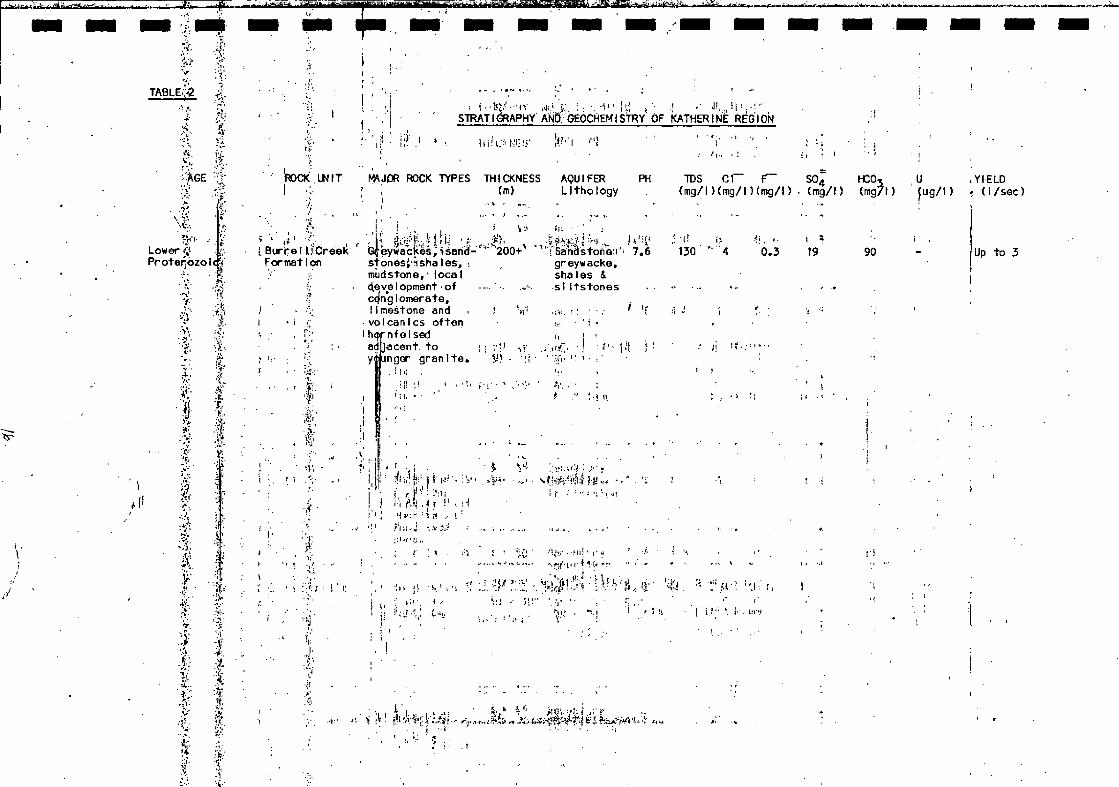
TABLE2 ,
• :.;. , •'
4 .'
1 STATIGRAPYND .
GEOCHEMiSTRY OF KATHERINE REGION ., 4
-:
.,,
: AGE '
F)CK WIT MAJOR RCK TYPES THICKNESS AQUIFER PH TDS 1 SOA u YiELD, . • . Cm) Lithology (mg/I) (mcj/i) (mg/i) (mglI) (mg/i') (ugh) (I/sec)
Calnozolc iç: Quaternary ' 4
AIluvium,.solI 7 Sand & 7.80 415 8 0 5 ;214,' *
Gravel.
Muliaman Bod' Lower Sandstone 9 slIt- 0-15 Sandstone — — — — — —'
'Not Known -. i,Pretaceou,s stone 9 ,pebbI -,, 1 j'IorIzon. -•- r
sandstone 9 clay-
stone,
UNCONFORMITY4--- ----------- --- ------------------ — ---- ----------- ---- — ----- — --- ------ — ----.-- --- ----- — ----- ' ---
Oi- dovicin -, PoIIoo SlilcIfied 25+ Not In 7.96 384 6 O..W 0.3 • 402 0.2., •.Not Know (not -..,. Limastono . limestone, sandy the in the area
•' limestone, lnvest .
igatlon I area.
Lower OrdovtianJinduckln . Sandy limestone 50+ . 7.11 2574 20 3.55 1860 46 0.10 WormatIon c ferruginous sand- - •.
- h stone s shales, . •.
,algai mlcaceous 5lits,.1 .-p .
- limesto-ne..
;...,,.•. -
''
. - . . '
. ••,
:-"
OISOONFORMIT'*, -.-i_----------- !. . L.------------------ 7
--- .-.. ------------ 7 ------------------- 7— -------------- 7------------ 7 -------- ---7
-U- -. ;-.-
Lower Ordovl'cian :ManbuIIo ., Llmostoiio, thin - I .- •.,
,cLimestone clayoy and sandy .. member re- ':'- lenses, algal - 90
• errei to as'. -i limestone, red .!. .SprIngvaIe •'. rnicaceous silt •-
r
- • 4 .
,
bedsin thls 1 stones pink shale,' ' ' ' F report. T. calcareous sand It
• stone, quartz • sandstone, detrltai . ,• -
It . SI itstorIe , L JJ1 r
"-V --- - •':- II
':r 1?
I 1 . I - • -
: -'•• . .
, • •-• '''i'::i' '
- . ' r -
, . •- hA --
-, . .4 ,
• : - 1 -t
- • -M M , i I . M, M - M - - - -:.
- I
p,;. .. TABLE '.
.,j STRATIGRAPHY. AND...GEOCHEMISTRY OF KATHERINE REGION
,GE I
ROCK WIT MkJ)R ROCK 1YPES ThICKNES AQUIFER PH 1DS C F =
$04 (m) Lithology (mg/I )(mg/I )(rng/I) (mg/I)
1. . iJNC0NFO8MiT..----r-------:--- --------- ---- ---- ---
Mid CambrlM• I
Indali •i.
LImestono.with .90 Cavlt!es 7.90, 370 6 0.14 . 0.8 Imestone Thln CIayey and In Limestone
sardy lenses . • . H: •:
4--: i- i H .._
------ - , .._.. ,.." ..- , ,•••
- ------------- 0ISCONORMI ----------
Lower darrthrI,n ntrlm f Ba It,ondesftes
-
-- - ---
5 - 50 Secondary 7.36 458 11 0.34 2.6 Ptateau
. i - porosity
:: • Vôlcanics In tsaIt.
.1. .,, ...... Carpen$arlanA Kombolglé Coarse quartz 50 - 100 Sthdstone 6.2 14 4 0.1 4
i. Formatió ,. sandstone, con— I.- 1' - . lorneratos, pebbIe
sandstone thin!
.J rhycdacite and .,
basalt members
. -- ----I Carpen1ariar
DISC0NRMi* -----------------------L
Edith RI;ver j Rholltp 5 - 45 Secondary VoIcanI r rhodales,ande-
,. poçosit ,
.. . . IgrlmbrItes. Bas8I ... -
• conglomerate and
.. .. p sandstbe Ioca1ty
id.eIoed
UNCONFMII ----------------- - ------_ ---------- --------- -- ---------- Lower Proter,zic Cul len ian Ito Blot itb an Ito 7 Not in 6.95 506 9 0.63 4
nodiorIte - SpIrg In Ed1t RIer) ;theae '?
.; adamel life. of Inves- :• L :- L
iff
i_ •i I. J . - I.
r jH i...
•
.. •l I:, .-. . . . . : ;pi i
- - - - -,.
p.
FCO3 U. YIELD (mg/I) (ugh) (i/sec)
315 0.34 Up to 60
445 0.30 -
10
Up to 3
No ksown bores In this formation
- p
39 30
- -
• II •
.1
0
—__—------ — — '-.-
- - --- - - - - - - - - - - - - -
TABL . ...: H., • STRAT I GAPHY ANb GEOCHEM SIR? OF KAThERINE REG JON ç. L 1 iit1 l I
. 1
.
AGE • CKI.t4IT WIJDR ROCK TYPES THICKNESS A9UIFER PH 1DS Cf f SO ICO- U YIELD (m) Lithology . (mg/I)(nig/I)(mg/I) (mg/i) (mg7I) ug/t) (I/sec)
Lower• .1;.[BureIUCreek
•:.
ywackés,4sanI- 2OO+ 1Sa1hdstohoI' 7.6 130 4 0.3 19 90 — Up to 3 Proterozoi • Formation stones"ishaIes, greywacka,
mtjdstone, local shalos & - - - development of ..............siltstones • •••-
ccngtomorate, •' / llmetoneand •
I i • VOIC8flIC5 often i.
IhqnfoIsed I
. :.i . adUecent, to - . i., • vkincir LrAn1t.. . .... I, 1 . ••
-. • t . . • . IN
- .
4 . I ey.
r I
.: • . , I .... .
I.
1 L' 1 - - •.•
• : ••, . I. _
i •.
i t
I. I
i . -., . • .......... -,.- .• ..I . lo
I t L I i I 1
4 Ic
•1I I LII
F .. ii• - -, . . • I • . . ,.
H.--
4
I . : I

- - - - -
5102 Mg. S.C.
100. 2700
24 28 510
24 40 610
- 2 -
- - 740
- - 646
22 28 490
24 37 700
- - . 735
- - . 735
- - 576
- .31 563
- • 43 129
- - 623
27 37 700
27 41 810
33 43 820
42 729
- -
TABLE 3.
KAThERINE GROUNDWATER tNVESTIGATION - CI4EMICAL ANALYSES (mq/t)
I.N. R,N,' P.14 0 I.D.S. Cl- SO4 HOC3 F IOTAL Na K. Ca. Fe0 HARD
I NESS
13 ... 408. 7.8 574 365 170 368 ... 2.5 685 315.0 68.0 , .119 CIS
16 , 596 - 59 5 is 0.0 6 31 0 23.0 - -
21 1345 7.5 290 6 6 351 0.2 286 1 10 2.0 62 0.1
23 • . 1443
". 7.5 39 18 21
4153 0.3 37O F
5.0 3.O 84 b 1
28 1448 7.7 667 3 2 523 0.2 (1
398 93.0 4.0 40 - • .,
55 1439'- 7.7 - 5 - 525 - 430 - - - -
59 3908 - - - 400 - 316 - - - -
60 .3908 7.0 300 Or 3 366 0.1 284 .4 1 0 3.0 I
.72, 0.1
61 -F
3027 6.8 ., :420 ii
8 2 525 0,2 410 5.0 2,0 108 . 8.8
62 ,3025\ 7.1 331 12 L. 0 266 - 344 - - 64 -
63 I3026, • 1 363 12'! 0 257 - 428 :- . . I , •' ••F ,,
64 ..:3028: 7.6 - II - -
- - - -
75 ,,2902j 7.4 331 7.5 0 200 0.0 338 4.4 2.4 82 0 1 1
76 '2522 7.4 450 11 0 284 0.0 464 5.2 1.2 114 0. 1
78 1
1- 1
4143 7.3 25 - - - 345 - - - -
79 p4077, 7.0 1360 '1 51 527 01 1 368 6.0 2.0 110 0
80 1 4278 7.3 430 8 0 267 0.0 423 4.0 1.0 102 0.0
83 4420, 7.6 745 4 10 543 0.4 436 50 2.0 104 0 1 1 • - ' . . 84 H4523' 7.5 453 11'! 0 290 0.0 453 4.0 0.7 110 0.1
85 I•'.• 'L
4524 ''
8.6 ' . II.
'- 12 . t ' - - 274 •- -
86 ':
1 54525 .. 8,1
-!. T.568
. .( 12 - -
'• . -
. 217 - - - - 4. .'
H'
660

- -
TABLE 3.
LN.
• 89
90
- 91
92
• 94
98
- 103
111
118
120
121
123
• 124
• 130
136
- 137
• 143
145
• 147
- -
- - - - - -
-: -
: ' '' - .•
KATH fINE GROUNDWATER INVESTIGATION rCHEM1CAL ANALYSES (m/1) 4 - •. . .4
In'
R.N.k. ftH. T.01.S..- CI. .)4 CO3 F TOTAL Na K. Ca. Fe. S102 Mg. HARD NESS
I ,.
I !, P •• 4648;' 69 . 6 '- 2-7 - 408 - - 105 - - -
4600' 7O 428 11 0 2O - 06 - - - - -
4709 69 518 6 24 7 0.0 332 06 - 12
4859 78 270 '. 8 119 5 0.2 250 .... 10.0 2.0 57 ._L • 21 19 26
4881 7.1 35 4 0 6 j 0.2 388 4.3 T,7 • 0.0 13 35
4886 79 415 8 J5 215 , 0.0 368 3.6 1.6 83 •,. 0.2 - ,. 38
8088 ': 82 350 ' 6 4 332, 1.7 31 e j
44
5042 .73 . 397i 12 0 '241. 0.0 322 •, 33 2.2 -i
•. 41 •.f--
. 0.1 r?
- •-.
5329. 72 364 :. 8 ;6 5 0.1 328 4.0 2.0 110 0.2 21 34 ,
5771 73 444 4 0 2 4 0.5 356 5.0 1.6 75 0.0 - 40
5853- 7t.1 390 10 -2 2 2 0.6 368 . 5.0 2.0 78 0.2 30 38
5854. 8:1 282 •:-- 14 0 1 3 . , Trace 294 6.0 , 2
10
g 28 Trace . - 54
5905 - 4 0 1 3 7.8
5906.851 -: - 1 - 364 . - - 0.7. - -
6469 12 - 8 - 9 - 390 - - - - - -
6670, 64 - :- 14 - 542 - . 490 i.; - - - , - - - .•,
6662 7 2 500 5 6 62 i 0 '1Iir11.° .O 0.5 16 73
6879. 400 12 . 3 .0.3 • 342 20.0 :l7.0 p.p48 0.6 44 p Pj 60
6885.- 73 380. ;. 5 2 $9 , 0.3 433. '..,j 3.0 1 1 0 103 0.2 26 40
6687 7 7 340 18 4 6 1L 200 2.O 1(45 I. 1 . 26 34
4'
41 •',, A i r: t'
----- -•.---.--••
•- - -
S.C.
741
779
470
660
590
715
700
79
600
482
i,500
520
700
800
880
70O
700
1550
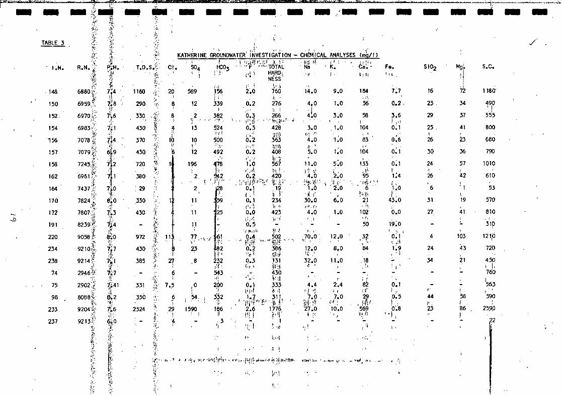
TABLE3
4. KAThERINE GROUNDWATER INVESTIGATION CHEMICAL ANALYSES (m/l)
- I .N. RN. . P.H. T.D.S. Cl. SO4 r M03 F TOTAL Na K. Ca. Fe, 5102 Mg. S.C.
'.' HAD
• .
• 148 6880;.. 74 1160 . 20 .
589 156 2.0 760 14.0 9.0 184 7.7 16 72 1180
150 •~
6959k, ..8 290 8 12 339 .
0.2 276 4.0 1.0 56 0.2. 23. 34 490 F •
152. 6970.. 7,6 330 •i 8 2 382 0.3 266 40 3.0 58 3.6 29 37 555 I 4r. I
• 154 6983•. 7I 430 . 4 13 524 0.3 426 3.0 1.0 104 0.1 25. 41 800
156 7078 4 370 10 10
Fl
500 0.2 363 4.0 10 83 0.6 26 23 680 1 1IF .1•t
104 0.1 30 36 790 157 -. 7079 6•.9 430 . 6 12 492 0.2 408 5.0 1.0
158 .
7245 4. 42 720
:•
1 196 .
478
. .. ..
1.0 567 11.0 5.0 133 01 24 57 1010
162 6961 iLl .
380 .
: 2 42 0.2 420 4.0 2.0 95 14 .
26 42 610
I F tliIi I I I
164 7437 7o 29 . 2 j28 0.1 19 1.0 20 6 1.0 6 1 53
170 7824,. 8.0 330 . U 11 59 0.1 234 30.0 6.0 2,1 43.0 31 19 570 •!. :P . 1••i FIr! -
172 7807.. 7.3 430 ii 25 0.0 423 4.0 1.0 102 0.0 27 41 810
191 8239.., 7,4 . - 11 - 0.5 - . - - 50 19.0 - - 310
7 t • 220 9058- ?0 972 it 17.
• 61. 0.4. ...502 70.0, 12.0 32 0.1 4 103 1210
. 84 19 24 43 720 234 9210i,.. 77 430 23 2 0.2 386 12.0 8 1 0
•j .
238 9214: 71 385 27 8 32 0.3 131 32.0 11.0 .18 34 ?l 450 4I
74 2946 - . 7.7 - 6 - 543 - 430 - - -, - - - 760
•yt- • .; •
• . 75 2902 741 331 •. 7.5 .0 200 0.1 333 4.4 2.4 82 0.1 - - 563 Itpi
98 8088:: 5i.2 350 -' 6 54. 332 1. . 311 7..0 • 7.0 29 0.5 44 58 590 F
233 9204* 7.6 2524 29 1590 186 2.6 1716 27.0 10.0 569 0.8 23 6 • 250 I r 3
237 9213 60 . - • 4 - •
.3 - 1 - - - - - - 2 . •1• : . • I •
- -
SliM. OF CAT IONS
29.16
5.46
7.78
6.27
6.14
8.70
6.89
9.49
8.84
8.91
9.14
33
::
37
35
37
34
I.
oil
C)
- -
_
- -- - -- - - - I- in - tj
TASLE4 .;L! j.J '. • . KAtJ1ERlNEGR0UNDWATERINVESflIGATIoN CHEM1CALANALYSESthecj/I) •
•- Ii LN. R.N. .CIt CliSO4 $04 lO3 ICO3 SUM.OF K H Na+?( Ca, Ca Mg
% % LI ANIDNS
13 408 10.3Q • 52.L 3,54 16 93 30 19.87 13.70 1.74 15.44 53 5.49 65 8.23
16 596 • •'l
0.42 .
- .
-•' - .p
0.O - - 0.13 0.59 0.72 - - - - .. .
21 1345.:: 0.1 3 0.13 • 2 .75 95 6.61, 0.04 0.05 0.09 2 3.09 56 2.30
23 1443 I
0.5.1 .... 0.44
I
i 5 .! •43. I
8,38 O.22..0.O8.. 0.30 . 4.19 I
54 3.29
28 1448 . •. . I!. ,. . i 0.09 7 0.04 0 857 9 8.70 405 0 10 4.15 66 2.00 32 0.12
1. 55 1439 0.1 8660 - - - - - - - -
59 3908 - :'.
•. - . - - 61, 6
60 3909 : ' 0. 24
•• 4 0.06 1
¶ 6.0 95
.
6.29 0.17 . 0.08 0.25 .
4 .,. 3.59 I
56 2.30
61 3027 0.23 3 0.04 0 8.61 97 8 88 0 22 0.05 0.21 3 5.39 62 3.04 ii 1i . -.1I
62 3025 0 3 7 0.00 0 4.36 93 4.70 - - - - 3.19 - -
63 3026 0.3 : 7 0..00 0 4.21 93 4.55 - - - - 1.40 - - r •
75 2902 0.2. . 6 I. 0.00 0. 3.28 .
. 3.4 0.19 0.06 0.25 4 4.09 59 2.55
76 2522 : 0.3 I.
6 1 •
0. .0 4.66 . 1.4
9 .,•
. 4.97 0.23 -.
0.03 . 0.26 3 5,59 60 3.54
78 07
• . ••' _i. Ii 79 . I4077 0.2 3 . Ott 1 8.64 96 6.98 0.26 0.05 0.31 4 5.49; 62 3.04 .......
• 83 4420 0.1. 1 . 0.21 1 8.90 96 9.22 0.13 0.05 0.18 2 5.19 58 3.54 Ii I. Ill
84 4523 :0.3. . 6 0 0 4.75 94 5.06 0.17 0.02 0.19 2 5.49 60 3.40 1 II' T 1
85 4524 0.3 s - -i - - - • - - . . - - - - - .
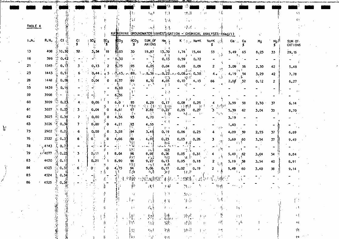
86 4525 0.4 •• - . -; - -: - • - - - - . . - - -
; : •. .
II I p Ii
I II
)
I
II
j.: ••• •. I • •' i? • Il •• . . -,•,. . -
t.... .- . •I tIII . . I
I I
: . . .
-
.; ; .•,. . .
.. ...t- .- -..
TABLE4 ,
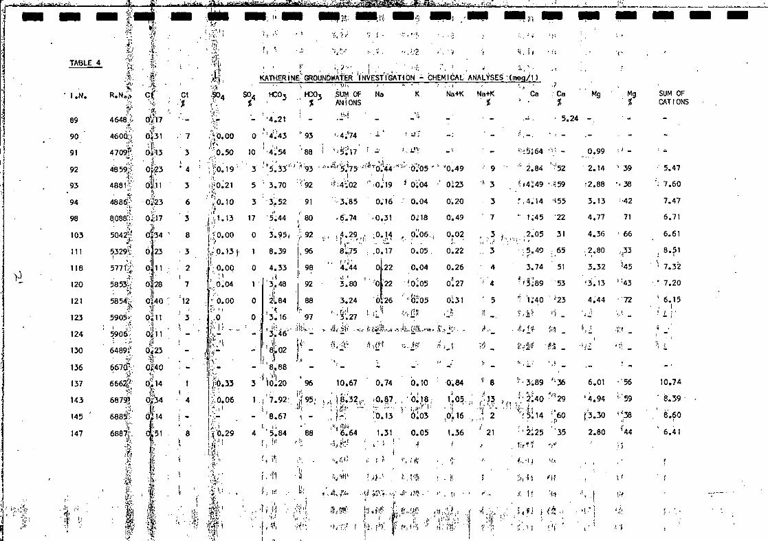
KATHERINE_GROUNDWATER _INVEST1GATON -_CHEMICALANALYSESlmeg/I)
R,Pl. CE CI 1904 $04 ICO3 ICO3 SUM OF Na K Na+I( Na+1 - Ca Ca Mg Mg SUM OF
CAT IONS ANIONS -
89
.1:,.
4648
.
Ol7 - - 4.21 - - - - - - 5 24 - - -
90
•
4600.)
-,
O31 7 0.00 0 443 93 '-4.74
91 4709 013 3 0.50 10 454
88 5 Ii - - - 564 - 099 - -
92 48 59, 0.23 '4 0.19 3 5 331
93 4t175 rQ44 l o 05 0.49 9 2 8' 52 2.14 '39 547
93 4881 ojii 3 0.21 5 3 70 92 ? 4 02 0.19 0.04 0 23 3 4 49 59 2 88 38 7.60
94 •
48W, -
•O23 6 I_
,0.10 3 3.52 91 :3.85 0.16 0.04 0 0 20 3 -
'4.14 Ii55 3.13 :42 7.47
6 74 0.18 0.49 7 1.45 22 4.77 71 6.71 98 8088 Ol7 3 1 13 17 5.44 80 0,31
103 5042' 0f34 8 jO.00 0 3.95 •92 ,., .29.,. 0.14 006.. 0.02 .3 .2.05 31 4.36 66 6.61
111 5329. 0 23 3 1 8.39 96 .8.75 .0. 17 0.05. 0.22 3 .5.49 :65 2.80 .33 8.51
118 -.
571i 1•.
011 2 • 0.00 0 98 4.44 022 0.04 0.26 4 . 3.74 . 51 3.32 45 7.32
120 5853 028 7 0 04 1
.....................................
348
I;
I 92 3.80 O 22 0.05 027 4 89 53 1 3.13 43 7 20
121 5854 040 12 0.00 0 2.84 • 88 3.24 0.26 f05 0.31 5 1.40 23 4.44 72 6.15
123
.c.
5905 O11
-
3
.
.0 0 ,.L 3.16
f 97
...,r.i 3.27
!•- -i -•
1 -. .- -
-.: _' . - -
124 5906 0611
130 6489 0123 - -- - •1T, :. A,R-
8.02 - -
136 6670. O4O . - .1L-
- 8.88 •
- I,
- . - -.
I, - -. - .,. -. - •_
I - -,
137 666* 0.14 1 f0 33 3 0 1 20 96 10.67 074 010 0484 1 8 3 89 0 36 6.01 56 10.74
143 687 0.34 4 0 05 7 92 95 J8 32 0.87 0.18 1.05 13 240 29 4 94 59 8.39
0.13 0O3 0 16 2 5
14 60 3 30 38 8 60 145 6885 Q14 - - - 8.61 - r.
147 6687.. 51 8 0.29 4 5.84 88 6.64 -
1.31 0.05 1.36 21 --
225 35 2.80 ( 44 6.41
'Il
- .. I.
I F I
a l
._. -
IX
:
••
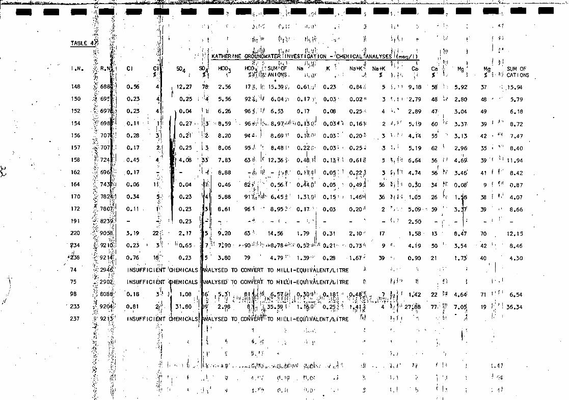
TABLE4 1 I
KATHERiNE GROUNDWATE INVESTIGATION CRE1'1ICALANALVSES (meg/I) I
I.N. §. R.N. 1 CI CI SO4 i4
1.1003 1.0O3 iSUM0F Ma Na+K Na-FK Ca Ca Mg Mg SUM OF .iANi0NS:, I' CATIONS
248 688 056 4 12,27 78, 2.56 173. 1c; 15.3 0.61 0.23 0.84 5 9.18 58 5.92 37 .15.94
150 0.23 4. 0025 5.56 92 6.04;i 0.17) 0.03 0.02 3 2.79 48 2.80 48 5.79
152 .697 0.23 4 0.04 It 6.26 96, 1 i 6.53 0.11 0.08
0.25 4 ' 2.89 47 3.04 49 6.18
154 698 .0.21 1 0.27 8.59 - 96 8.97 0.IQ 0.03 O.l6. 2 5.1.9 60 3.37 39 8.72
156 707 0.28 31 0 21 12 8 20 94 , 8 69" 0. 11 0 03 0 20 3 4 14 55 3.13 42 H
157 707 0.17 21 025 3 8.06 951 I B 48t' 0 2 0.03 1 0.25 3 5.19 62 296 35 8 40 41
4.6"1. 158 724 0.45 08 33 7.83 53 1236 0. 4 I 1 i 0.13i 0.619 5 q 664 56 ii 39 ' 11.94
162 696 0.17 - - 8.88 - i - r 0 2(1I 0 05 1 0.22 ? 3 4.74 561 r 346 41 8.42
164 74 0.06 11 0.04 l 0.46 82 0 564 0 44,C' 0.05 0 49 56 1 030 34 t 0 08 0.87
170 7824 0.34 5 0.23 I I
4 5.88 91 1 6.45,q 0.15 1 1 45 36 1 1 1.05 26 1 5 38 4.07
172 7807 0 11 1 0.23 3 8 61 96 8 95 0 17 003 020 2 5 09 59 3 7 39 8 66
291 8239) - 023 1 - - - - - - - - 2.50 - - - -
220 •Y905 3.19 22, 2.17 5' 9.20 63 k . 14.56 1.79 0.31 2.101 17 1.58 13 8.47 70 22.15
34 921 0 23 3 0 65 7 790 90 -8.78 0 52 0 21 0 73 9 4 19 50 3 54 42 8 46
•9214T 1 0.76 1 0.23 5 3.80 79 4.79 1.39i 0.28 •1.61 39 - 0.90 21 2.73 40 4.30
74 294k INSIJFFICIE,.hO-IEMICALS VkYSED TO CX)NVERT TO MILLI-EQIJIVALENT/LITRE
75 . 2902 INSUFFICIENT ¶HEMICALS I NALYSED TO CONVRT TO MI1LIE9U 1IVALENT/L ITRE I
98 ;8O8 O.18 3 2.08 6 5.31. 8 l..J 1 I 0.48,.. I 7 A 1.42 22 4.64 71 1. 6.54 I
9204 I
I 0.81 2 1 31 80 I...... ..233 9 2 %8 B 35 59 ' I 1&. 0 25 1,4w 27'8 77 7 05 19 36 34
237 9213 INSUFFICIENT EMICALS ALYSED TO VER1i'TO MIftI-EQUIVALENT/LiTRE r
2
1
. .
'Sr ].Crnt
o "
tint
€r
S
eq
?
S
t
I
KATHERINE REGIONAL GEOLOGY
Reference ;:. •
•:................. I . : '.. . 0 .
QUATERNARY I °° I A//uv/vm,sOiL . .. . '\\3•(
:• ! !
LOWER Muflomon co*nIetote CREThCEOUS
)5, ii thnducn Formotion CmIS tdJtt?'°' ,
C>J ,1 I C] acifin fiat. . . CAMBRLAM I ember
t Tindali Limestone äStY7 //mestOfte chert bosa's '
;$
LOWER CAMBRIAFsfl?)
Antrirn Plateot)i VoEconics J
00*0 w / &j/tije ñ hMictas o
:CUPPER
C PROTEROZOIC .° Member F Pum Besaft and pyeot/osh
Pdn '
:11 EdsTh iyer VOtwtrCs [ Poe tj Prtoc1usfc ond
__
LOWER - I Pd Epietlor/fe
a. PROTEROZOIC EQs/c &caakt, pyroC/OS/ICS and
I . I (AGICONDIAN !c? Dorothy Votconics [-.........j tuffacecas sediments.
I •'"•' ' .•..!k I ' SYSTEM t:
BwreII Creek EormatIn L Pb 3I11sk'ns and gisywocke pityiete
II . 1 1 1 1 II • ,! I II 1 1 1 1 1 II ;•:-:::;;
it
II . III II I I IIII !I ! • Ktri i IIIIII!'I I ' :
11.11 1 1 liii... I I r 1 i
II. • II II ! !II,•III ! ' : II !: I ! II • I , III ! I!I I . 1 1 II. i: !\ ':; • !,1: ::: L:!:
, I moiniy residual
I • li ltr • • •I •• •• .•II ---
S_'r?c.t/e • •I•t II II I • 'I••
• I :• '': : : An//c/lye
.• ::;:i!: I
: T,,ndafbecflthg. •1
• : • ::! I •• .Lill
A : • ':
oral ftim 9i.tft.Recoanoissan0eSvrvoyOOtd.
I Highwoy
,• Secondary rood. F
. N River.
Creek. I
I.' . . t I I RoiLway
J
C • •
i.: •1
!•. •: ::. .
ZUUVLYjt
. nt REGIONAL GEOLOGY
: 0 2 4 6 8 o Kilometres.
— — , . . . I
., ,. . 1:100000
..t

-
_v *
'a..:
kl44r
t •5906 \
.-
71
/ I
/ 9t9e_ 9212(D)
(tw Q_ (DO',
596
t
ThERINE 946
NS4aBi ; ;: T04420
523
V L L-
I \, ' 408
r . t :648 i3
460Oj07 . I yçtgw '¼3025
I I I : indol
- . 1.,\ I , , •
k..
II
I 80 8
I" ;: Th;44d SdS
0 02:4709
. 5908
I I
Hta;\ '1 . --- • . .
.&
I n It
/1 LOCATION OF BORES IN KATHERINE INVESTIGATION AREA FIG 3 2
I00I00o!_eID
I I I
. .. .. I
II
.-------- ¼ F
1 I
0&E 0 1 4ts*t,
t
% \ ATHERINE GORGE " NATIONAL. F&RK \
Il) : ! 1 N\ !" \ '\ . )I ! •-\ I -
1 l3 t \ t
N I \
N/\d1 I
\
\ . .
'
92
0 42Th
)H1J• 4119214 -' I'I LEGE$W (3) / /1 • .
02078
—
c_ : -- ___ ------ --N Si5ttered No N — - - - — lie
—
rr
jf tt
°Ji . .
6960 . .
I
f t ê6682 .
¶2 ;ã 1 4'4dt
1-i-"H
ki 4 .
_~v:-• \
:r00a
& \\ •
Creeks. • .
A-. Do,,*
S --t , •1 I ____ . ' \ 0tttO Raulwoy.
-t
t ' FORMATION AQUIFER 0 \ . . ' k ¶
20167 Mks . ' 0 Quaternory. . .+
ManbuflQo \ \
"C .
; G lindal H
I • : '-S. : Aatrini Platsau VoIcanta. S
c222
, 4
- - 0 Kombolgie I 4/
HH © I • I ti( : :H H • / H
20757 " 2
20756 207430
flQQQP4 '
L V .
WI

I 8400000 N
S
0
3 3
-ç
I
L
I I,
)
I
I
1
3
p
3
L9
I
N /
cmssing
E ll
LEGEND
Major Rood /1
Secondary Rood
Creek 4
Jinduchin Formation
Springvale Beds
Tindot Limestone
!sopad in metres
Cloystone
Limestone
Shale
Slistone
Sandstone
11U Conglomerate
Source: A.&Ec.(l976,l977)____
Li
S C3
LI1 &
-4
• H
IN
3
\ H
4 ,aEossQFAcHS FIG.4
Scale 1:100000
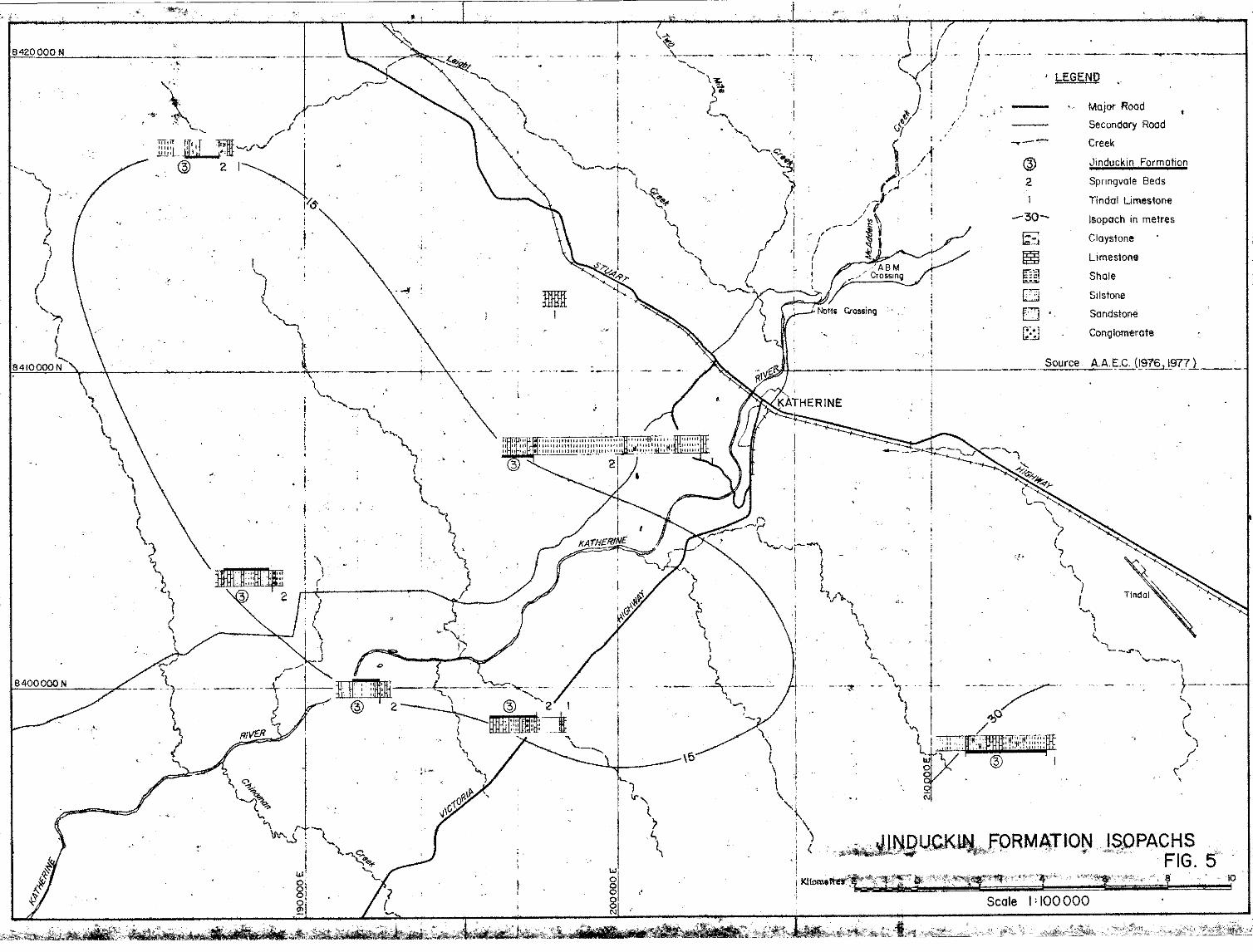
N
I 'LEGEND
MujorRod
ft t I secondoryRood
ILI
Creek
2 t'—_ a \ j I Jinduckin Formation
SprinqvoleBeds
I Tindol Limestone
30
C Isopach in metres
Claystone
Limestone c ABM crossIng Shale
Silstone F4ottsGrasstng. Sandstone
ConIonierote
\
H 4
__\ KATHERINE
-'------__. -
KAMEAME 4
ct
-
I \\ a
" a ,SNDVcKUJPRMAT 1ON 1S,PPACHS
HG.5
-' -I- IIflW - I t/ a I ( caie i'iuuuuu I, NI

a . • .... ••[.?•* • . . .. . :: . :• •
I •• . : I \. •.
I I t •1 t I '
.• ' -;- -R •• .
' 1 I \
• . , : I '
: •
&t i ! ! . . '•
• ••. j...' S-- '
I -' - -------- \ ' I
4420000* : --- — H- ------ . S _ 1k -t( i__i I \ I I •1
• f N ti _J . i I \_ I p—_v•_.-__
---- I . t \— I
••;• - '-• \ •• ••-• • ' ••• t •, - .•
0p61 0
_____
— -- — --- — ---------------------— b
— r ;
__________
— I • — --- - )
' , -"Ia- - I . .-
tj4 * >
\ t
Pk-
cATHERINE GOØGE NATIONAL PARK \
¼,• 1., 4 N k ______j
P
dMGADDENS CREEK AREA
N -
: — p
4I000_••
•• : \' .•- )• . '
L . H : : \
: • • - H
\ LI 1 ' I :• : \ •. . . : • LEIGHT-TWOMILE ? AREAB • 1 f ø' '----- t . ! • ;
I \
EK\ sk
• • . . .
—c _,'__ . \
••: : '\
A—oj1' \ AREA
L U 1-' g k \
- L p , ( -I '-I- '-- • \ •
. ; 1 } , / — •1 . •
¼ , H ' , [
, . 1 _t \ • : .
IL
\ (I No'ts+ t \
- -N.-y Crossinq
. .. ? •.:: 4 __•\
? - KATHERINE RIVER ALLUVIUM
\ INVESTIGATION AREA
-- .- s— . ' 1 \ ; • • I
t • < " ' • . '
8400000
— • i c,J• . • . • f . . : : • " . - 7 •
Sp04 • #. t. • H : - . H •( —
• KATHERINE 4r :. • I I' •
• -- —-- . , I
: . '-I • • I . \
• q ! ' 1
---- I • , .:! : <• #_
I
L •
\ I
S --( •H : - S I ( . • *
'\ 'Th;Th•. H . . \
I : ' "
Tindci ' Lii '1 IA-
c ( \
•
! • : • 1 \
B39QQQQN
t ç \ • a . ! • . ' ' GROUNDWATER INVESTIGATION AREAS
L •• 1' • , :
.) H • c • ( • ••, .. FIG.6
4
I t't*T_
1; •1 I
F
2 4 6 5.
,L'- 2 2 ' c-I' r •' g I . IooQo
la

I A
%em
--- —a- - y__ •_' . *
Notts
I
a I , I
-.- .--- -
'4
S I,
.i ze
Crossing -
*
q_\
11IF-€6 ii
Y
REFERENCE
I QUATERNARY
I • i CRkUS
Mulltungn Beds
TJndal Limestone CtikN { I
LOWER Antrim
I CAMBRIAN(?) •
PlatequVolcqnics .
z U UPPER Edith River s... : PROTEROZOIC Valcenics
Ir - r
•F LOWER
a. PROTEROZOIC Ea Bucrelt Cr*s Pormaflen I AGICONDIAN \ I
' SYSTEM I j( KATHERINE RIVER A.. L4WVIUM iNVEsTIGATION
. ,, FIG. 7 • : .:i 4. 1.: .: .:.::.!:?. : . :ka..*.:.. ::..: ..... •:øie+a:* . . ... :....j
200 100 0 200 400 600 800 Metres i. iioCDO
V I I I
-= f I I RSKJ
°'tUy I 8 B
. . . .
1 • . j •r!4 R-'\ R.N.92;24
BC;
. . ' / . ':!i!i; !!•I!Ji: . • i;:• ii •' i!H: 1' /7
- - - :1 I•IiI.iII;III!I::iI.••II e- '
,
. €
•
. I
!.!!!.! I!IiiIIi:i:i
•!
'•,I•iI• : :I! . • : ..
: • • • : • Y
: -- jil N 1hiihhiii:hh1 '': :I IIi 1hI III IiI I 11111
))
/ I -
;
:
S
0
S
V
S
Y 077/1
• q• ----------
/ •c'7 n RJ'49190
L 4 . kMhl
q •
. cN
I.tk ! II {.'L 1 • ! '1 ' !I !!
£mt. !!
tI;* .
LEGEND
Geologicci Boundary inferred Geological Boundary
-. .- Geological Cross Section A_ I A Seismic Refraction I P.D.R. Traverse B_ B Seismic Refraction Traverse
0 t7/3 Auger Hole
e RIFJ.9212 Control/Investigation Bore
with R.N. number I Sealed Road
_---t---- Track Fence
L
L
p
I . ...c...:'..

: '"
,
N: , , , ,
,
c
' e qCP ? '2<" • :.
V65 6- 1 1 '- :
r
cR
100 , an
•S%%
WRINE
oo
9O
Plb
85 PIb 4
- 80
, F ,
•t 75 ' - . ' .. . 5 *
- : RN9192 - R.Ni932 RN989 R.N9190 . R.N.9191
cc— 00— t
o:T— ocH- - Sciids4ctays grovelS, I '
i,iestone nodu'e F I 40 I - . - .
: Silt, sond,clay. $111 ; ' t t .cga Weathered ;n$ermed,04e voICics .
. - . . Sartd,4rcvet a clay. . . 121 - Porphyritic aridesite(?) c®bining $36 Coarse sQrxJ,qroveI &cIay. .
Pue K-felsper phenocrysts; chlorIte - 4o Grovel g n Broken then I - 67 - present, vuggy horizon elb Silistone S inter Weathered basalt o jweathered bQStU?
152 weoth&s baseD 1'
- . 18-2 Siltstone : bedded gre'iecke 17 . is i 1b Siltstone f.77 .- -
I • C 19-5 - Greywacke cont*n] ?Ib SlitsiDne ! • Rb pyramidal quortz !
crystals,sorne pyrite Pib Sistone- red a qrey
. , a chlorite Minor 24-I .-. I! . coloured.
- . 249 - silistone interbeds.
30•0- - .
Reference"
QUATERNARY arnntsmi Qo Z UPPER o Edith River */coitiCS F PUC 4
SCALE . - - 1 ~ PROTEROZOIC . I i
HORIZONTAL 110,000 H 4 . m
p • VERTICAL 1:500 Q( - > - - - ó
LOWER
l PROTEROZOtC
LX$NER I r SwisH C-en formation ri
CA&ABRIAN(O ,in/nmPJcteoQl-b/cvrncs I a a- IAGICONDIAN\ iz •.-:•:-.-::.•.-::-J •
IkSYSTEMI
A - - KATHERINE RIVER GEOLOGICAL CROSS SECTION - FIG. 8
JY : ,... .• •aj' nit..J.L:4 Zt&1 .IiitLt . .'I'i ..,j...1 1 - c-

F,
U
-- -
. , ••i .:: .:. . . .: .. . ..: . . . .: . : . . :;::. :: : E:.::j.:
. . •...i...•::•:.:.•ii:.•••..c .
.•.
LEIGHT — TWO MILE CREEK ÔEOLOGY.
Reference
•:•.*:E
:!
•: •
ir .. •::.
d
. ..
. .
...
. ..
. .•.:
. ....
. . . I
p
. .
I
0
9QUATERNARY fl.*
0 . o LOWER Mullarnon Beds ';'. : ftrrugrnovs $cndstne. coç/Oflerdte
CRETACEOUS jiI;Iw: qvar sOfldstcn.
2
0i
J LOWER Anirut Plateau Volconics I SQ$c/f, do/e,i/e op.! tufibccouc gadstone
1 CAM BR IAN
1 Kombog'e F sandstone areywockConQ/OmecO/8,
dl UPPER C PROTEROZOIC TI Andesite, docile, basalt, pyroc/astics and s1
Edith River Volconics Eue : 3 tuffaceous sed,ments
m
— - N (eOQ/Ca/ boundary.
-.-' - 7— Creek
— Res'thWty low on traverse I/re
) RA 9202 Regimred bore.
4' 'It a

... . .. . ... .
). .. .. •:: .
•:
. ./
I..
A B f
ArecA • Areab
e e 0.
r I ANDESITE
, t
I . . I . E'ue . C • ,1. - .
DACITE I
S ANDESITE
L
.fr . .-. .. . .... .. .. H . . .. .v S..
4) j
... . . . -
; RN9202 RN9201 RN9203 RN9204 I . 0 0 ---- °r iSand ctdy qtvel _ -1 .
. Sand gravel clay slit cLay gravel 2 15 th 1 cloy
, 5 . 5 - 4.3 - Sand cicy gravel with [JPorhntic Atidesite 40
t. 7.4 - Sand claygravet with 64 some detnlal trachytes
- some detrital trachyfes 64 .' Prphytil;c Andestle
: . r 4
t 154--Trathyte(?)
fr g Dacrte(?) Quartz filled
, . fractures
4::
t Dacite (?) microcrystolline . . . ..
It, trphyrttitndethe --- -
I --n--. ----
I ----.i- = .--
REFERENCE
p 'I' a t :Lg Prphritic andesite 7 . QUATERNARY . Qu AIhiviu/n
0 - .
I . •
01 LOWER
CRETAcEOuS Mullatncje beds N
LO I . $
Mi W 1Ck-&
ER RIAN AntnrnPtsftj
r I
z N Kambo!gie P kj m UPPER Formation
0 <PROTEROZOIC
- Edith River Lu Velcanics I
87-
LEIGHT — TWO MILE CREEK GEOLOGICAL CROSS SECTION
Scale Horizontal I 10000 Vertical 1000 FIG 10 5.,