JSPS (Japan Society for the Promotion of Science) Multilateral Cooperative Research Program Coastal...
29
JSPS (Japan Society for the Promotion of Science) Multilateral Cooperative Research Program Coastal Marine Science 2001-2010 n, Indonesia, Malaysia, Thailand, Vietnam, Philippi
-
Upload
phebe-griffith -
Category
Documents
-
view
220 -
download
2
Transcript of JSPS (Japan Society for the Promotion of Science) Multilateral Cooperative Research Program Coastal...

JSPS (Japan Society for the Promotion of Science)
Multilateral Cooperative Research Program
Coastal Marine Science
2001-2010
Japan, Indonesia, Malaysia, Thailand, Vietnam, Philippines

4 projects
Project 1: Water circulation and the process of material transport in the coastal area and marginal seas of the East and Southeast Asia (P.I., T.Yanagi, Kyushu Univ.)Project 2: Ecology and oceanography of harmful marine microalgae (P.I., Y.Fukuyo, Univ. of Tokyo)Project 3: Biodiversity studies in the coastal waters of the eastern and the southeastern Asia (P.I., K.Matsu-ura, National Museum)Project 4: Pollution of hazardous chemicals in the coastal marine environment and their ecological effect (P.I., N.Miyazaki, Univ. of Tokyo)

Project 1

Regional Studies
Manila Bay
Java Sea
Gulf of Tongking
Malacca Str.
Banpakong Est.

0
100
200
300
400
500
1999 2000 2001 2002 2003
0
200
400
600
800
Cag
es (
un
it)
Pro
du
ct.
(X
100
0 fi
sh)
Production
Cages
Fish cage dev.
-30
-26
-22
-18
-14
-10
-6
-2
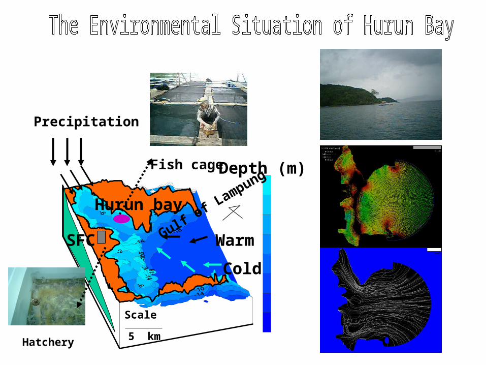
Precipitation
Hurun bay
Scale
5 km
Fish cage
Hatchery
Gulf of L
ampung Depth (m)
Warm
Cold
SFC

- 3 0
- 2 6
- 2 2
- 1 8
- 1 4
- 1 0
- 6
- 2
2
Depth (m)
November 03 (Tr D-W), January 04, March 04 (WET=NW Monsoon), April 04,May 04 (Tr W-D), June 04, July 04, August 04, September 04 (Dry=SE Monsoon)
- Temperature, Salinity, Transparency, DO, DIN, DIP, TOM, Fitoplankton - Precipitation, Solar Radiation and Wind
8 Stations3 Stations

Tran D-WDryWet
Tran W-D
0.080
0.474
0.108
0.409
0.556
0.1870.326
0.103
0.000
0.100
0.200
0.300
0.400
0.500
0.600
Wet Trans-W-D Dry Trans-D-W
DIN
(m
g/l)
DIN(S) DIN(B)

18.6
5.4 3.2
23.3
0
5
10
15
20
25
Wet Trans W-D Dry Trans D-W
Res
iden
ce t
ime
(day
s)
30.0
30.8
30.4
30.1
29.4
29.6
29.8
30.0
30.2
30.4
30.6
30.8
31.0
Wet Trans-W-D Dry Trans-D-W
Te
mp
era
tur
( oC
)Seasonal variations in average residence time and water temperature
Suhendar and Yanagi (2006)

Recommendation
Carrying capacity of fish culture in Hurun Bay variesseasonally.
Cultured fish number and bait must be reduced during transition seasons.

Special field observations in the Upper Gulf of Thailand
9-11 Oct., 4-6 Dec. 200313-15 Jan. 200412-14 May, 7-9 Oct. 200426-29 Jul., 1-4 Nov. 200523-26 Jul. 2006
TransparencyCTD, DO
Water samplingPlankton net
Light characteristics
GPS buoys tracking

Objectives
1. To develop the air-correction algorithm of ocean color images2. To develop the water-correction algorithm of ocean color images
3. To develop the hydrodynamical model4. To develop the ecosystem model
5. To investigate the relation between surface convergence and primary production
What is the generation mechanism of the patchiness structure in the ocean?

Local algorithm for chl.a
Chl.a(μg/l)=181.4exp(-4.74R) R=Rrs(520)/Rrs(565)
Matsumura et al. (2006)

28 Oct 2003Oct 2003
MERIS MODEL
Anukul and Yanagi (2006)
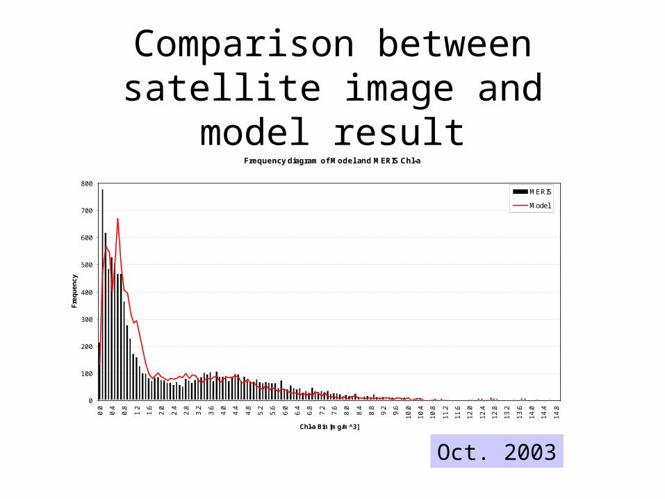
Comparison between satellite image and model result
Frequency diagram of Model and MERIS Chl-a
0
100
200
300
400
500
600
700
800
0.0
0.4
0.8
1.2
1.6
2.0
2.4
2.8
3.2
3.6
4.0
4.4
4.8
5.2
5.6
6.0
6.4
6.8
7.2
7.6
8.0
8.4
8.8
9.2
9.6
10
.0
10
.4
10
.8
11
.2
11
.6
12
.0
12
.4
12
.8
13
.2
13
.6
14
.0
14
.4
14
.8
Chl-a Bin [mg/m^3]
Fre
qu
en
cy
MERIS
Model
Oct. 2003

5 Dec 2003 Dec 2003
MERIS MODEL

3 Jan 2004Jan 2004
MERIS MODEL

16 Jul 2005 Jul 2005
MERIS MODEL

19
Chlorophyll and Vertical DiffusivityCU – 6 (Jul 2005)

20
Sensitivity Analysis CU – 5 (Oct 2004)
Normal
Weak Wind
Strong Wind

Observation data
1996.3 ~ 1998.12
8 stations (-1m, middle, bottom)
T,S,Chl.a
1
2
3
4
5
6
8 7

Pasig川からの負荷500 km2
3 m
10 m
35 km
8 m
Box model analysis
HorizontalAdvection and diffusion
鉛直移流・拡散 溶出
Load from Pasig river
VerticalAdvection and diffusion
Release

DIN budget in Manila Bay
2
5
2
26(=8+18)
1
4
19
3
0
30(=20+10)
22(=21+1)
4
9
Apr. (dry)
19(=3+16)
D > P
D < P
D≒P
D > P
D < P
D > P
( 2.21 )
( 4.44 )
( 2.67 )
( 4.47 )
( 7.04 )
(DIN μmol/l )
( 1.66 )
( 1.96 )
( 7.32 )
( 9.44 )
( 0.10 )
deposition <photosynthesis
Nov. (rainy)Deposition >
photosynthesis
Load 1= 8.05×10⁶μmol/s

Aliasing62.10 days
Aliasing58.75 days
Aliasing45.71 days
Aliasing173.22 days
AVISO
Morimoto(2008)

Tide error ( M2+S2+K1+O1 )
Morimoto(2008)

Ecological roles of seagrass beds
Buffering effects of waves and currents
Protection against erosion
Absorption of nutrients and production of oxygen
Primary production comparable to tropical rain forests
Spawning, nursery and feeding grounds for fishes and molluscs
Habitat for epiphytic animals and plants
Contribution to bio-diversity
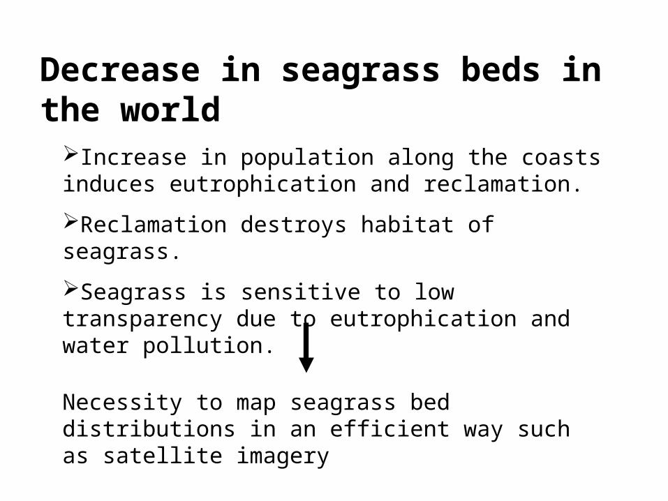
Decrease in seagrass beds in the world
Increase in population along the coasts induces eutrophication and reclamation.
Reclamation destroys habitat of seagrass.
Seagrass is sensitive to low transparency due to eutrophication and water pollution.
Necessity to map seagrass bed distributions in an efficient way such as satellite imagery

Cooperative study on seagrass mapping using ALOS Avnir-2 imagery
Prof. M. Ibrahim Seeni Mohd (Universiti Technologi Malaysia) Sea truthing: Langkawi (March) and Tioman Isles. (This year)
Dr. Mahatma Lanuru (Hasanuddin University) Sea truthing: Barrang Isles. (next July)
Counterpart: Dr. T. Komatsu (ORI, Univ. Tokyo)

Project 1:Water circulation and Material transport
Future from 2008 to 2010Numerical ecosystem model is a very powerful tool for synthesize physical, chemical and biological data in the coastal sea.
We will carry out interdisciplinary study using ecosystem model coupled with hydrodynamical model in Gulf of Thailand Manila Bay Jakarta Bay Gulf of Tonking Eastern coastal sea of Malaysia
Satellite remote sensing on sea-grass beds and coral reefs using ALOS in the coastal sea of Malaysia.


![[Text version] For the Sound Development of Science · This book has been edited by the Japan Society for the Promotion of Science (JSPS), an agency that provides “kakenhi” Grants-in-Aid](https://static.fdocuments.in/doc/165x107/5fb17702047add1999538a39/text-version-for-the-sound-development-of-science-this-book-has-been-edited-by.jpg)