Jet Propulsion Laboratory A Geostationary Microwave ... · ¥Recent mission study ¥Prototype...
29
EUMETSAT/AMS — September 25, 2007 National Aeronautics and Space Administration Jet Propulsion Laboratory California Institute of Technology Pasadena, California Lambrigtsen GEO/MW Sounder EUMETSAT/AMS Conference Amsterdam; September 24-28, 2007 A Geostationary A Geostationary Microwave Sounder Microwave Sounder for the Next Decade for the Next Decade National Aeronautics and Space Administration Jet Propulsion Laboratory California Institute of Technology Pasadena, California Bjorn Lambrigtsen Alan Tanner, Todd Gaier, Pekka Kangaslahti, Shannon Brown Jet Propulsion Laboratory California Institute of Technology Jeff Piepmeier, NASA GSFC Chris Ruf, U. Michigan National Aeronautics and Space Administration Jet Propulsion Laboratory California Institute of Technology Pasadena, California
Transcript of Jet Propulsion Laboratory A Geostationary Microwave ... · ¥Recent mission study ¥Prototype...

EUMETSAT/AMS — September 25, 2007
National Aeronautics and
Space Administration
Jet Propulsion Laboratory
California Institute of Technology
Pasadena, California
Lambrigtsen
GEO/MW Sounder
EUMETSAT/AMS Conference
Amsterdam; September 24-28, 2007
A GeostationaryA Geostationary
Microwave SounderMicrowave Sounder
for the Next Decadefor the Next Decade
National Aeronautics and
Space Administration
Jet Propulsion Laboratory
California Institute of Technology
Pasadena, California
Bjorn Lambrigtsen
Alan Tanner, Todd Gaier, Pekka
Kangaslahti, Shannon Brown
Jet Propulsion LaboratoryCalifornia Institute of Technology
Jeff Piepmeier, NASA GSFC
Chris Ruf, U. Michigan
National Aeronautics and
Space Administration
Jet Propulsion Laboratory
California Institute of Technology
Pasadena, California

EUMETSAT/AMS — September 25, 2007
National Aeronautics and
Space Administration
Jet Propulsion Laboratory
California Institute of Technology
Pasadena, California
Lambrigtsen
GEO/MW Sounder
Mission
Justification

EUMETSAT/AMS — September 25, 2007
National Aeronautics and
Space Administration
Jet Propulsion Laboratory
California Institute of Technology
Pasadena, California
Lambrigtsen
GEO/MW Sounder
Note: The NRC panel put PATH in the 3rd group, reflecting their perception of the maturity of the required technology
Recent developments indicate a higher level of readiness, and it may be feasible to implement PATH earlier than thought
= GeoSTAR!
NRC Decadal Survey

EUMETSAT/AMS — September 25, 2007
National Aeronautics and
Space Administration
Jet Propulsion Laboratory
California Institute of Technology
Pasadena, California
Lambrigtsen
GEO/MW Sounder
Strategic
Plan (2006) Goal 3A Study Earth from space to advance scientific understanding and meet societal needs
Variability: How are global precipitation, evaporation, and the cycling of water changing?
Response: What are the effects of clouds and surface hydrologic processes on Earth!s climate?
Consequences: How are variations in local weather, precipitation, and water resources related to global climate variation ?
Science questions
Prediction: How can weather forecast duration and reliability be improved? (How will water cycle dynamics change in the future? )
Science
Plan (2007)
Missio n s Weather FA: GeoSTAR: Geostationary synthetic aperture microwave radiometer
NA
SA
Roadmaps
(2005-06) Weather F A GEO Microwave sounding: Improved short-term forecasts
Climate Describe and understand the state of the climate system through integrated observations, analysis, and data stewardshi p
Increase lead time and accuracy for weather and water warnings and forecasts
Improve predictability of the onset, duration, and impact of hazardous and severe weather and water events
Strategic
Plan (2005) Weathe r
Increase development, application, and transition of advanced science and technology to operations and services
Observatio n s Capable and reliable observation infrastructure: Platform investments needed to meet high priority program requirements
Prioritie s
Forecasts Forecast accuracy for high impact weather: Accurate short-term hurricane intensity forecasts
Provide timely and effective acquisition and delivery of satellite-derived information that supports requirements from the mission
goals NOAA Mission
Support Provide applied research to ensure the quality, reliability, and accuracy of current and future satellite products and services to support the NOAA mission goals
NESDIS
Strategic
Plan (2005) Geostationary Satellite
Acquisition
By 2010, through its technology infusion planning activity, NESDIS will have determined the best methods for the following technologies: … Microwave imaging and sounding systems from geostationary orb i t
GOES-R
(2004)
GPRD P3I requiremen t s
(A large number of P3I products requires a microwave sounder)
Reduce the error in 48-hour intensity forecasts for hurricane-strength storms by at least 10 kt within the next five years, with an emphasis on improved forecasting of rapid intensification and decay, and decay and reintensification cycles
NO
AA
Hurricane
Intensity
WG (2006)
Science Advisory
Board repor t Improve hurricane observing systems
Needs: Early identification and reliable forecasting of the track and intensity of tropical cyclones Geographic distribution and magnitude of storm surge and rain accumulation totals during and after landfall Observations: 3D atmospheric temperature & water vapor; SST; precipitation; all-weather conditions (clear and cloudy); temporal refresh every 15-30 minutes
Scientific objectives: Improve model representation of cloud formation, evolution and precipitation Use time-continuous all-weather observations to impose new constraints on models Mitigate requirements on models by enabling frequent re-initialization by observations Enable major scientific advances in understanding of El Niño, monsoons, and the flow of tropical moisture to the U.S.
NR
C
Decadal
Survey
(2007)
PATH missi o n
Mission & payload: MEO or GEO; Recommend all-weather sensor suite on future GOES platforms; Require 50 or 118 GHz and 183 GHz; Microwave array spectrometer; Suitable for start in 2010 time frame
A MW Sounder Is Broadly Justified

EUMETSAT/AMS — September 25, 2007
National Aeronautics and
Space Administration
Jet Propulsion Laboratory
California Institute of Technology
Pasadena, California
Lambrigtsen
GEO/MW Sounder
Why GEO Microwave Sounder?
• GEO sounders achieve high temporal resolution– LEO: Global coverage, but poor temporal resolution; high spatial res. is easy
– GEO: High temporal resolution and coverage, but only hemispheric non-polarcoverage; high spatial res. is difficult
– Requires equivalent measurement capabilities as now in LEO: IR & MW
• MW sounders measure quantities IR sounders can!t– Meteorologically “interesting” scenes
• Full cloud cover; Severe storms & hurricanes
– Cloud liquid water distribution
– Precipitation & convection
• MW sounders complement IR sounders– Complement primary IR sounder (HES) with matching MW sounder
• Until now not feasible due to very large aperture required (~ 4-6 m dia. in GEO)
– Microwave provides cloud/”cloud-clearing” information• Requires T-sounding through clouds - to surface under all atmospheric conditions
• A MW sounder is one of the most desired GEO payloads– High on the list of unmet capabilities

EUMETSAT/AMS — September 25, 2007
National Aeronautics and
Space Administration
Jet Propulsion Laboratory
California Institute of Technology
Pasadena, California
Lambrigtsen
GEO/MW Sounder
AIRS Vis/NIR
AIRS MW-only retrievals
AIRS quality flags
• Use with confidence
• Use with caution
• Do not use
Color background:cloud fraction
AIRS IR+MW cloud-cleared retrievals
White: Poor retrievals
IR sounders vs. MW
soundersSpatial resolution
--IR vs. MW: 10-15 km vs. 15-50 kmhor.res.; 1-1.5 km vs. ~2 kmvert.res.
Basic sounding accuracy--IR vs. MW: 1 K vs. 1.5 K for T(z);15% vs. 20% for q(z); none vs. 40%for L(z)
Scene coverage--Cloud free: IR outperforms MW (butIR = MW in coverage)
--Partly cloudy: IR < MW (IRdepends on “cloud clearing”, anoise-amplifying process)
--Fully cloudy, storms: MW faroutperforms IR (“cloud clearing”cannot be done)
Hurricanes & severestorms
--IR can only see cloud tops, oftenobscured by cirrus shields
--MW can see to surface (except inheavy precipitation: switch toconvection observations)
Summary--IR is best suited for globalobservations and storm precursorconditions in clear sky
--MW is best suited for observingin/through storms and precursorconditions in clouds
IR soundings fail with evenmoderate cloud cover
Storm/cloud cases are not wellsampled - i.e. there is significantsampling bias
MW soundings fail only in thepresence of precipitationwith current algorithms
New algorithms will remedythat
Example
Tropical system near Florida observed with the Atmospheric InfraredSounder (AIRS)
(May 16, 2006)
Why Not Just IR Sounders?IR vs. MW: Pros & Cons
EUMETSAT/AMS — September 25, 2007
National Aeronautics and
Space Administration
Jet Propulsion Laboratory
California Institute of Technology
Pasadena, California
Lambrigtsen
GEO/MW Sounder
GeoSTAR

EUMETSAT/AMS — September 25, 2007
National Aeronautics and
Space Administration
Jet Propulsion Laboratory
California Institute of Technology
Pasadena, California
Lambrigtsen
GEO/MW Sounder
GeoSTAR Highlights
• Time-continuous microwave sounding from GEO
– Tropospheric temperature & water vapor sounding @ 50/183 GHz with ! 50/25km resolution
• Functionally equivalent to AMSU
• Stand-alone all-weather temperature & water vapor/liquid soundings
• Rain mapping; convective intensity
• Tropospheric wind profiles (only feasible from GEO)
– Primary focus on hurricanes: Observation and forecasting of intensity• Significant synergy with GPM & scatterometer: PATH adds tropo.winds & fills in spatio-temporal gaps
• PATH addresses significant hurricane issues: now-casting, improved intensity observations/forecasts
• Urgent societal need for PATH mission in view of possible increased tropical cyclone activity
– Greatly-improved boundary layer, cloud and precipitation process modeling• Major science advances in the understanding of El Niño, monsoons and tropical moisture flow
– Ready for implementation phase now• Technology & prototype development has advanced TRL more rapidly than anticipated
• Ground-based prototype: Excellent performance; breakthrough development
• Ground-based proof-of-concept prototype has been developed• Excellent performance => Breakthrough development
• Recent mission study• Prototype design meets measurement requirements & is ready for flight development
• Mission development can begin ahead of the 2010 NRC recommended start date

EUMETSAT/AMS — September 25, 2007
National Aeronautics and
Space Administration
Jet Propulsion Laboratory
California Institute of Technology
Pasadena, California
Lambrigtsen
GEO/MW Sounder
Applications
• Weather forecasting -Improve regional forecasts; severe storms– All-weather soundings - standalone, but also complements IR soundings– Full hemispheric soundings @<50/25 km every ~ 15-30 minutes (continuous)
– “Synoptic” rapid-update soundings => Forecast error detection; 4DVAR applications
• Hurricane diagnostics -Quintessential hurricane sensor– Scattering signal from hurricanes/convection easily measurable
– Measure location, intensity & vertical structure of convective bursts
– Detect intensification/weakening in NRT, frequently sampled (~ 10 minutes)
– Measure all three phases of water: vapor, liquid, ice
• Rain -Complement GPM– Full hemisphere @ ! 25 km every 20 minutes (continuous) - both can be improved
– Directly measure storm and diurnal total rainfall: predict flooding events
– Complements GPM/TRMM: fill space-time gaps through “data fusion” methods– Measure snowfall, light rain, intense convective precipitation (per Weng and per Staelin)
• Tropospheric wind profiling -NWP, transport applications– Surface to 300 mb; very high temp.res.; in & below clouds– Major forecast impact expected
• Climate research -Hydrology cycle, climate variability– Stable & continuous MW observations => Long term trends in T & q and storm stats
– Fully resolved diurnal cycle: water vapor, clouds, convection• Southwest monsoon; tropical moisture flow into the US; genesis of severe storms
– “Science continuity”: GeoSTAR channels = AMSU channels
EUMETSAT/AMS — September 25, 2007
National Aeronautics and
Space Administration
Jet Propulsion Laboratory
California Institute of Technology
Pasadena, California
Lambrigtsen
GEO/MW Sounder
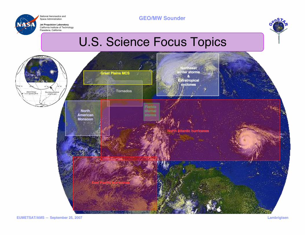
Great Plains MCSGreat Plains MCS
FloridaFlorida
diurnaldiurnalstormsstorms
TornadosTornados
NorthNorth
AmericanAmerican
MonsoonMonsoon
East Pacific hurricanesEast Pacific hurricanes
North Atlantic hurricanesNorth Atlantic hurricanes
NortheastNortheastwinter stormswinter storms
&&
ExtratropicalExtratropical
cyclonescyclones
Boundary of optimal
antenna gain
U.S. Science Focus Topics

EUMETSAT/AMS — September 25, 2007
National Aeronautics and
Space Administration
Jet Propulsion Laboratory
California Institute of Technology
Pasadena, California
Lambrigtsen
GEO/MW Sounder
Example: Hurricanes
Observations with
Microwave Sounders

EUMETSAT/AMS — September 25, 2007
National Aeronautics and
Space Administration
Jet Propulsion Laboratory
California Institute of Technology
Pasadena, California
Lambrigtsen
GEO/MW Sounder
TCSP Example: Hurricane EmilyTCSP: NASA hurricane field campaign, Costa Rica, July 2005
HAMSR (ATMS prototype built at JPL) flying on ER-2
•July 17, 2005
•Overflights at 0730-1200 UT
•Strength @ 0900: 938 mb/130 kt,
declining (strong Cat. 4)

EUMETSAT/AMS — September 25, 2007
National Aeronautics and
Space Administration
Jet Propulsion Laboratory
California Institute of Technology
Pasadena, California
Lambrigtsen
GEO/MW Sounder
Vertical slicing through hurricane Emily - July 17, 2005
EDOP
HAMSR
Nadir along-track view
4 km
5 km
6 km
7 km
8 km
9 km
10 km
Scan swath view
7 water vapor
sounding
channels
gives slices
at 7 heights
MW sounder
Is equivalentto radar!
Hurricane observations with MW sounder (HAMSR) compared with doppler radar (EDOP)Observations from NASA TCSP campaign, Costa Rica, 2005
“Radar reflectivity” - partially height resolved• Convective rain• Ice water path
• Convective intensityMethodology under development
183-GHz scattering index, ~5-10 km
Radar Emulation with MW Sounders
EUMETSAT/AMS — September 25, 2007
National Aeronautics and
Space Administration
Jet Propulsion Laboratory
California Institute of Technology
Pasadena, California
Lambrigtsen
GEO/MW Sounder
GeoSTAR
Instrument
Concept

EUMETSAT/AMS — September 25, 2007
National Aeronautics and
Space Administration
Jet Propulsion Laboratory
California Institute of Technology
Pasadena, California
Lambrigtsen
GEO/MW Sounder
GeoSTAR System Concept
• Concept– Sparse array employed to synthesize large
aperture
– Cross-correlations -> Fourier transform of Tb
field
– Inverse Fourier transform on ground -> Tb field
• Array– Optimal Y-configuration: 3 sticks; N elements
– Each element is one I/Q receiver, 3.5l wide (2.1
cm @ 50 GHz; 6 mm @ 183 GHz!)
– Example: N = 100 " Pixel = 0.09° " 50 km at
nadir (nominal)
– One “Y” per band, interleaved
• Other subsystems– A/D converter; Radiometric power
measurements
– Cross-correlator - massively parallel multipliers
– On-board phase calibration
– Controller: accumulator -> low D/L bandwidth
Receiver array & resulting uv samples
Example: AMSU-A ch. 1
15 12 9 6 3 0 3 6 9 12 15
18
15
12
9
6
3
3
6
9
12WindSTAR Array Configuration
X Offset (cm)
Y
O
f
f
s
e
t
(
c
m
)
60 50 40 30 20 10 0 10 20 30 40 50 6060
50
40
30
20
10
0
10
20
30
40
50
60WindSTAR U,V Coverage
U Offset (wavelengths)
V
O
f
fs
e
t
(
w
a
v
e
le
n
g
t
h
s
)
Arm #3 Arm #2
Arm #1

EUMETSAT/AMS — September 25, 2007
National Aeronautics and
Space Administration
Jet Propulsion Laboratory
California Institute of Technology
Pasadena, California
Lambrigtsen
GEO/MW Sounder
• Fourier imaging features– Basic imaging area is a hexagon
– Periodic nature of Fourier series creates
infinite series of secondary imaging hexagons
– Sources in secondary areas are aliased into
primary area
• Basic PATH configuration– 4-wavelength element spacing for optimal
performance
– Edges of Earth then extend into secondaryhexagons
– Those areas are therefore alias contaminated
– This is not a problem: unimportant areas
– Earth#s limb visible in 6 sectors
• Use this for calibration
• Region Of Interest– Maximum performance near center of
antenna patterns
– Pitch instrument ~3° N for focus in Caribbean
– ROI is largely free of alias
GeoSTAR Spatial Coverage
Region of maximum sensitivity

EUMETSAT/AMS — September 25, 2007
National Aeronautics and
Space Administration
Jet Propulsion Laboratory
California Institute of Technology
Pasadena, California
Lambrigtsen
GEO/MW Sounder
GeoSTAR Prototype Development
• Objectives– Technology risk reduction
– Develop system to maturity and test performance
– Evaluate calibration approach
– Assess measurement accuracy
• Small, ground-based– 24 receiving elements - 8 (9) per Y-arm
– Operating at 50-55 GHz
– 4 tropospheric AMSU-A channels: 50.3 - 52.8 -53.71/53.84 - 54.4 GHz
– Implemented with miniature MMIC receivers
– Element spacing as for GEO application (3.5 !)
– FPGA-based correlator
– All calibration subsystems implemented
Has been thoroughly tested at JPL
Performance is excellent
Breakthrough development!
Ground-based sounding demonstration underway at JPL

EUMETSAT/AMS — September 25, 2007
National Aeronautics and
Space Administration
Jet Propulsion Laboratory
California Institute of Technology
Pasadena, California
Lambrigtsen
GEO/MW Sounder
-Images reconstructed from 5-minute
interferometric measurement sequences
-Hexagonal central imaging area shown
-Aliasing from outside central imaging
area can be seen
These effects are well understood and
can be compensated for, but they will not
appear in GEO (background Is 2.7 K)
This was a first - a major achievement!
First Images of Real ScenesNovember 2005

EUMETSAT/AMS — September 25, 2007
National Aeronautics and
Space Administration
Jet Propulsion Laboratory
California Institute of Technology
Pasadena, California
Lambrigtsen
GEO/MW Sounder
Indoor Target!
-Developed a method to compensate for distortions when target is in near field
-Enables using near-field targets to measure the performance of the system
-Developed a mocked-up “Earth from GEO” calibration facility using this method
November 2005

EUMETSAT/AMS — September 25, 2007
National Aeronautics and
Space Administration
Jet Propulsion Laboratory
California Institute of Technology
Pasadena, California
Lambrigtsen
GEO/MW Sounder
Quantitative-Calibration Facility
Retrieved vs. measured temperatures
Red: Large pad (4#x4# controlled)
Green: Small pad (2#x2# controlled)Black: Main target (ambient)
Solid: GeoSTAR retrieval
Dotted: Thermistor average
Raw synthesized image
Processed image†
† De-aliased, ant.patt. Corr; Not sidelobe-corrected
“Near Field range”, JPL
GeoSTAR
Target
Temperaturecontrolled
padsBeacon
@ center
June 2006

EUMETSAT/AMS — September 25, 2007
National Aeronautics and
Space Administration
Jet Propulsion Laboratory
California Institute of Technology
Pasadena, California
Lambrigtsen
GEO/MW Sounder
NOAA
Study
1999 2000 2001 2002 2003 2004 2005 2006 2007NMP/EO-3
Phase-A
JPL R&TD: GeoSTAR calibration
Raw synthesized image
Processed image
“Near Field range”, JPL
GeoSTAR
Target
Temperaturecontrolled
padsBeacon
@ center
Absolute calibration
ACT: 183-GHz MMIC development
0
2
4
6
8
10
12
14
16
18
150 160 170 180 190
Frequency [GHz]
Gain
[d
B],
No
ise F
igu
re [
dB
]
300
400
500
600
700
800
900
1000
1100
1200
No
ise T
em
pera
ture
[K
]
Gain [dB]
NF [dB]
NT [K]
Breakthrough MMIC
performance
NASA/IIP: GeoSTAR ptototype
DRO
25.15 GHz
4-w
ay P
ow
er D
ivid
er
8-w
ay P
ow
er
Div
ider
Radiometers
1 - 8
8-w
ay P
ow
er
Div
ider
8-w
ay P
ow
er
Div
ider
Radiometers
9 - 16
Radiometers
17 - 24
+10 dBm
-2 dBm+8 dBm
-7
-10
Frequency
from QNX PC
(Optical Isolated)
Serial
RS 232
Phase Control
from CIB
DC Power
+5V, 150 ma
9
Phase
ShifterAmp
-1
Phase
ShifterAmp
-1
Phase: 0, 45, 90, 135 TP
Phase
ShifterAmp
Agilent 8247
Freq Synthesizer
25-27 GHz
DC Power
+15V, 100 ma
2
2
Alternate LO source
Compact receivers
Low-power MMICs
LO phase switching system: Ultrastable operation
Correlator:
• Efficient
• Redundant
• OK for ASICs
Feedhorns:
Low mutual
coupling
Innovative array layout
All required technology elements developed & tested
First images
at 50 GHz
by aperture
synthesis
NOAA & NASA
Mission Studies Design innovations
GeoSTAR Technology Development 2008 1998 2009

EUMETSAT/AMS — September 25, 2007
National Aeronautics and
Space Administration
Jet Propulsion Laboratory
California Institute of Technology
Pasadena, California
Lambrigtsen
GEO/MW Sounder
Test results
recently
published
A. B. Tanner et al., “Initial Results of the
Geostationary Synthetic Thinned ArrayRadiometer (GeoSTAR) Demonstrator
Instrument,” IEEE Trans. Geosci. Remote
Sens., vol. 45, no. 7, pp. 1947-1957, Jul. 2007
GeoSTAR on Cover of IEEE TGRS

EUMETSAT/AMS — September 25, 2007
National Aeronautics and
Space Administration
Jet Propulsion Laboratory
California Institute of Technology
Pasadena, California
Lambrigtsen
GEO/MW Sounder
MissionDevelopment

EUMETSAT/AMS — September 25, 2007
National Aeronautics and
Space Administration
Jet Propulsion Laboratory
California Institute of Technology
Pasadena, California
Lambrigtsen
GEO/MW Sounder
Notional PATH Mission• Objective: Observe US hurricanes & severe storms
– Primary: Atlantic hurricanes
– Secondary: CONUS severe storms; E. Pac. hurricanes
• ROI focused near E. Carribbean– Center @ 75°W, 20°N (permanently pitch GeoSTAR)
• Can be pointed in other directions
– 90+ % of visible disc is in alias-free region• Can be narrowed down (lower cost => risk mitigation)
– Highest sensitivity in “circle” of radius 45°• Exploring antenna designs to maximize high-sensitivity
region
• Adequate sensitivity with GeoSTAR– ~ 20 minutes “integration time” to reach 1 K for
water vapor (183 GHz) in central part of ROI• T-band (50 GHz) is twice as sensitive/responsive
• Exploring designs to improve these numbers
• Exploring methods to increase temporal resolution
• Note: Primary mission objective is NOT precipitation!
– Focus is on high-value soundings in cloudy/unstable conditions
– Bonus: Synergy with GPM, scatterometer, GOES-R (ABI, GLM)
EUMETSAT/AMS — September 25, 2007
National Aeronautics and
Space Administration
Jet Propulsion Laboratory
California Institute of Technology
Pasadena, California
Lambrigtsen
GEO/MW Sounder
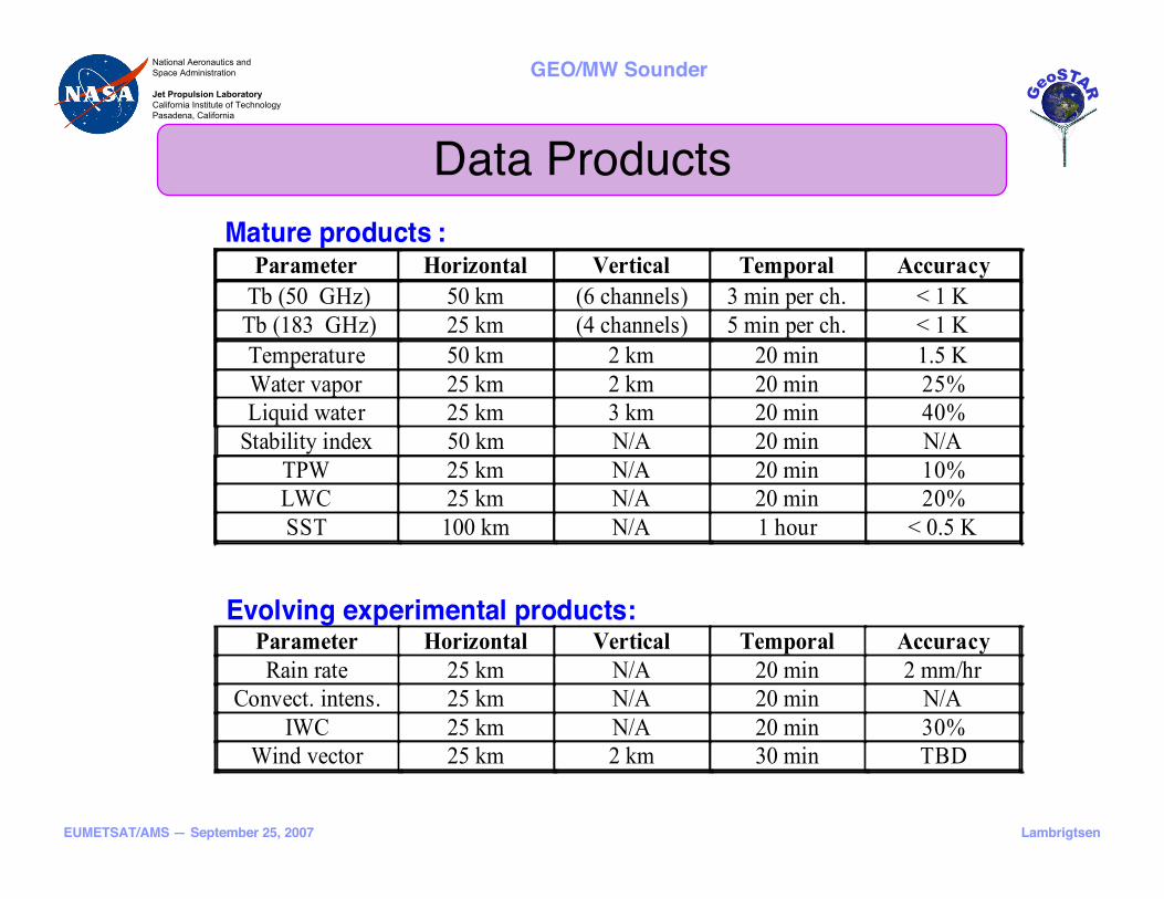
Data Products
Mature products :
Parameter Horizontal Vertical Temporal Accuracy
Tb (50 GHz) 50 km (6 channels) 3 min per ch. < 1 K
Tb (183 GHz) 25 km (4 channels) 5 min per ch. < 1 K
Temperature 50 km 2 km 20 min 1.5 K
Water vapor 25 km 2 km 20 min 25%
Liquid water 25 km 3 km 20 min 40%
Stability index 50 km N/A 20 min N/A
TPW 25 km N/A 20 min 10%
LWC 25 km N/A 20 min 20%
SST 100 km N/A 1 hour < 0.5 K
Evolving experimental products: Parameter Horizontal Vertical Temporal Accuracy
Rain rate 25 km N/A 20 min 2 mm/hr
Convect. intens. 25 km N/A 20 min N/A
IWC 25 km N/A 20 min 30%
Wind vector 25 km 2 km 30 min TBD

EUMETSAT/AMS — September 25, 2007
National Aeronautics and
Space Administration
Jet Propulsion Laboratory
California Institute of Technology
Pasadena, California
Lambrigtsen
GEO/MW Sounder
Platform Accommodation Example
Array arms folded for launch Stowed in Delta fairing Deployed on-orbit
Ball Aerospace

EUMETSAT/AMS — September 25, 2007
National Aeronautics and
Space Administration
Jet Propulsion Laboratory
California Institute of Technology
Pasadena, California
Lambrigtsen
GEO/MW Sounder
Roadmap
• Prototype: 2003-2006– Fully functional system completed - now tested & characterized
• Continuing engineering development: 2005-2008– Develop 183-GHz low-noise compact/lightweight multiple-receiver modules
– Develop efficient radiometer assembly & testing approach• Reduce cost per receiver
– Migrate correlator design & low-power technology to rad-hard ASICs
• Science and user assessment– Forecast impact: OSSEs under development
– Algorithm development; applications
• Development of space version (PFM): ~2008-2014– Start formulation phase in 2008-2009
– Ready for integration/launch in 2014-16
• Demonstration mission: ~2014-2016– Joint NASA/NOAA mission?
• Part of operational GOES or standalone PATH research mission
• Transition to quasi-operational mode after 1 year in research mode
– Joint NASA/ESA/EUMETSAT mission?

EUMETSAT/AMS — September 25, 2007
National Aeronautics and
Space Administration
Jet Propulsion Laboratory
California Institute of Technology
Pasadena, California
Lambrigtsen
GEO/MW Sounder
Conclusions• Prototype development has been a tremendous success
– Inherently very stable design; Excellent performance
– Measurements confirm system models and theory
– Breakthrough development!
• Technology risk mostly retired– Prototype demos all key technologies
– Remaining challenges are “engineering risks”
• Further risk reduction will focus on efficient manufacture of large number of receivers
• Design & fabrication of correlator ASIC is also an engineering issue, not technology
• Science potential is tremendous - no other sensor can match this– GeoSTAR is ideally suited for GEO
• “Synoptic” sensor - continuous 2D imaging/sounding snapshots of Earth disc
– Soundings in hurricanes and severe storms
• Water vapor, liquid water, ice water, precipitation - all vertically resolved
• Can derive stability metrics (LI, CAPE, etc.), convective intensity
• Now-casting: Detect sudden hurricane intensification/weakening
– Major advances in models: Diurnal cycle of all 3 phases of H2O fully resolved
• Urgent need for this mission

EUMETSAT/AMS — September 25, 2007
National Aeronautics and
Space Administration
Jet Propulsion Laboratory
California Institute of Technology
Pasadena, California
Lambrigtsen
GEO/MW SounderNational Aeronautics and
Space Administration
Jet Propulsion Laboratory
California Institute of Technology
Pasadena, California
GEOSTARGEOSTAR
HURRICANEHURRICANE
SENSORSENSOR
FORFOR
GEOGEO
COMING SOON:COMING SOON:
SEE THIS INSEE THIS IN
MICROWAVE!MICROWAVE!
This work was carried out at theJet Propulsion Laboratory,
California Institute of Technologyunder a contract with the
National Aeronautics and Space Administration.