ITEM 2 MINUTES OF LAST MEETING - hbcoast.co.nz Paku - He Toa Takitini Mike Adye – HBRC Monique...
56
Transcript of ITEM 2 MINUTES OF LAST MEETING - hbcoast.co.nz Paku - He Toa Takitini Mike Adye – HBRC Monique...


ITEM 2 MINUTES OF LAST MEETING
Report to: Clifton to Tangoio Coastal Hazard Strategy Joint Committee
Report from: Coastal Hazard Management Strategy TAG
Lead author(s): Monique Hulena, Executive Assistant, HBRC
Meeting date: Friday 6th March 2015
REASON FOR REPORT
1. This item presents the minutes and actions of the last meetings of the Clifton to Tangoio Coastal
Hazard Strategy Joint Committee held on 19 September 2014 and 5 December, 2014, which are
attached to this report.
RECOMMENDATION(S)
A. That the minutes of the meeting of the Clifton to Tangoio Coastal Hazard Strategy Joint Committee
held on 19 September 2014 be adopted.
B. That the minutes of the meeting of the Clifton to Tangoio Coastal Hazard Strategy Joint Committee
held on 5 December 2014 be adopted.

!
UNCONFIRMED
MINUTES OF A MEETING OF CLIFTON TO TANGOIO COASTAL HAZARDS STRATEGY
JOINT COMMITTEE !!!Date: Friday!19!September!2014!
!Time: 11.00!�!2.25pm!
!Venue: Council!Chamber!
Napier!City!Council!231!Hastings!Street!NAPIER!!
!Joint Committee Members: In Attendance:!!Tania!Hopmans!�!Maungaharuru-Tangit !Trust!!Peter!Paku!�!He!Toa!Takitini!!!Peter!Beaven!�!HBRC!Christine!Scott!�!HBRC!Tania!Kerr!�!HDC!George!Lyons!�!HDC!Bill!Dalton!�!NCC!
Mike!Adye!�!HBRC!!Helen!Codlin!�!HBRC!Liz!Lambert!�!HBRC!!Monique!Hulena!�!HBRC!!Dennis!Morgan!�!HDC!Mark!Clews!�!HDC!!Mike!Maguire!�!HDC!!Dean!Moriarity!�!NCC!James!Minehan!-!NCC!!Wayne!Jack!-!NCC!!Richard!Reinen-Hamill!�Tonkin!& Taylor Stephen Daysh � Environmental Management Services
Ex office: Fenton Wilson � HBRC
WELCOME / INTRODUCTIONS / APOLOGIES
Mike Adye welcomed everyone to the meeting and stated as this meeting is the first one we want to gauge from the group specific issues they wished to ensure are dealt with and the direction going forward. Mike introduced Richard Reinen-Hamill from Tonkin & Taylor who has an in-depth understanding of the Hawke�s Bay coast. Richard will provide background information. Mike also introduced Stephen Daysh from Environmental Management Services who will provide a suitable staff member to project manage this work. It was noted that the election of Chairman for the Joint Committee would be discussed after the background information from Richard was presented to give the group enough information before making a decision. Apologies were received from Gavin Ide - HBRC, Gary Clode - HBRC, John O�Shaughnessy - HDC, Bill McWatt - NCC, Rob Bell - NIWA and Graeme Taylor - NCC.

2
BACKGROUND MATERIAL
In 2004 NCC/HBRC/Port of Napier worked together investigate in a proactive way issues and options for Westshore and determine what influence Port of Napier was having on coastal processes. USA professor Paul Komar was appointed. His report was published in 2005. Paul Komar was again commissioned to prepare a report specifically dealing with the long term impacts of climate change and the potential impact on the integrity of the Napier foreshore. This report is the main driver for the development of a Coastal Strategy. Richard spoke to his presentation on Clifton to Tangoio Coastal Hazards Strategy. General discussion took place on each slide.
ELECTION OF CHAIRMAN FOR THE JOINT COMMITTEE
Peter Beaven was nominated by Bill Dalton, seconded by Tania Kerr; and was appointed to Chairman of the Joint Committee. A Deputy Chair position was not appointed and will be discussed at the next meeting.
ADOPTION OF TERMS OF REFERENCE
The group discussed the Terms of Reference (ToR). Committee members identified a number of areas that require sharpening of the terminology.
· Voting (12.1) voting rights, stakeholder voting rights.
· Remuneration (10.1) for being present at the meeting for Tangata Whenua representation.
· Representation (7.1) if a member of the group are unable to attend they are able to have another person attend in their place.
· Clarification of terminology for �members� and �appointees�. The group agreed that as a Joint Committee their meetings will be public. However they also acknowledged the need for the Committee to hold workshops from time to time. The ToR will be signed off at the next meeting.
DISCUSSION INCLUDING EXPECTATIONS FOR THE NEXT MEETING
Items for discussion at the next meeting:
· Stakeholder list and engagement.
· Risks � what are the hazards/consequences.
· Vision � should focus on community.
· Stage one = Framework, process and roadmap at the next meeting.
· Objective of strategy: Describe a broad vision for the coast in 2100 & Determine options for managing or mitigating coastal hazard risks to make a more resilient community along the Hawke�s Bay shoreline from Clifton to Tangoio.
Before the next meeting:
· Prepare a list of stakeholders.
· Circulate the minutes, slides and advise of next meeting.
· Circulate the letter from Tonkin & Taylor that went to the Council meeting.
· Core Technical Advisory Group (staff from the Councils).
· Iwi and NCC representatives on the group to be finalised.

3
DATES FOR FUTURE MEETINGS / POSSIBLE FIELD FAMILIARISATION
The group agreed the meeting will be held bimonthly on either a Monday or Friday. The next meeting will be scheduled in early December 2014. A schedule of dates for the remainder of 2014 and for 2015 will be circulated to the group. An HBRC field trip scheduled to visit Clifton to Tangoio Coast is on 10 November 2014. Members of the Joint Committee and support staff are welcome to participate. An email will be circulated to the group seeking confirmation of numbers.
ACTION ITEMS
· Mana Ahuriri Inc to confirm their ongoing involvement.
· Napier City Council to confirm their representatives on the Joint Committee.
CLOSURE
There being no further business the Chairman closed the meeting at 2.25 pm on Friday 19 September 2014.

UNCONFIRMED
MINUTES OF A MEETING OF CLIFTON TO TANGOIO COASTAL HAZARDS STRATEGY
JOINT COMMITTEE Date: Friday 5 December 2014
Time: 9.00 � 12.30pm
Venue: Council Chamber
Napier City Council 231 Hastings Street NAPIER
Joint Committee Members: In Attendance: Peter Beaven � HBRC Christine Scott � HBRC Tania Kerr � HDC Bill Dalton � NCC Faye White � NCC Peter Paku - He Toa Takitini
Mike Adye � HBRC Monique Hulena � HBRC Gary Clode � HBRC Gavin Ide � HBRC Mark Clews � HDC Dean Moriarity � NCC James Minehan - NCC Richard Munneke - NCC Simon Bendall � Environmental Management Services
WELCOME / INTRODUCTIONS / APOLOGIES
Peter Beaven welcomed everyone to the meeting and stated this was the second Clifton to Tangoio Coastal Hazards Strategy Joint Committee meeting. Christine Scott gave a Karakia. Apologies were received from George Lyons � HDC, John O�Shaughnessy - HDC, Dennis Morgan � HDC, Tony Jeffery � NCC, Joinella Maihi-Carroll � Mana Ahuriri Inc., Piri Prentice � Mana Ahuriri Inc., Tania Hopmans � Maungaharuru-Tangit! Trust, Belinda Riley - HBRC
White/Dalton CARRIED
Simon Bendall introduced himself to the group. Simon is the Project Manager of the Clifton to Tangoio Coastal Hazards Strategy Joint Committee and the chair of the TAG meetings, he is employed by Environmental Management Services and reports to Stephen Daysh.
APPOINTMENT OF DEPUTY CHAIR
Tania Hopmans had been put forward but due to other commitments has declined. General discussion of more than one deputy was discussed by the Committee. It was agreed to adjust the Terms of Reference to allow the appointment of more than one deputy chair. A deputy chair position was not appointed, the turnout of members was noted as disappointing and it was agreed to defer to the first meeting in 2015.

P a g e | 2
2
10 NOVEMBER FIELD TRIP DEBRIEF
Mike thanked Committee members for their attendance at the field trip. General feedback was very positive and educational. The Committee was asked if they require other field trips in the future. It was agreed that site visits to specific parts of the coast when these were under discussion may be valuable in the future.
FINALISE AND ADOPT TERMS OF REFERENCE
The group discussed the Terms of Reference (ToR). Committee members identified a number of areas that require sharpening of the terminology.
· Definition of Coastal Hazards Strategy.
· Partner Council Members (3.1) additional text and to be added to the definitions.
· Meetings (6.2) to be removed as is covered off in 4.4 (Tangata Whenua Members.
· Election of Chairperson and Deputy Chairperson (12.1) change text as agreed to elect up to two deputy chairpersons.
The ToR was adopted subject to the above amendments being made.
Scott/Kerr CARRIED
HAZARDS TO BE INCLUDED IN THE STRATEGY
Gavin gave an overview of the types of hazards within the strategy scope. An amendment to recommendation 3 � sea level rise was tabled. This was due to the Parliamentary Commissioner for the Environment (PCE) releasing her report �Changing Climate and Rising Seas� after the agenda for types of hazards within the strategy scope was circulated. The Committee agreed that the recommended approach should include coastal erosion, coastal inundation from storm surge, tsunami and implications of sea level rise. There was general discussion on timeframes. The Committee agreed to 25, 50 and 100 year timeframe scenarios. Existing and future inundation risk assessments were also discussed. The Committee agreed to consider 1 or 2% AEP. Mike provided an update on the �East Coast LAB� (Life at Boundary) Project which is a new regional branded research initiative involving international science community to study tectonic plate interfaces. The project includes a significant opportunity for public education.
Mike discussed the concept of risk being the product of likelihood and consequence. In considering scenarios for sea level rise it is important that scenarios in addition to the most likely sea level rise are considered. The recommendations were adopted by the Committee including the following amendments: Recommendation 3 to include a new sub clause 3.6, agreed to add two other sub clauses: 3.7: Ensure that tectonic settling is considered in relative analysis. 3.8: TAG should consider a range of other scenarios based on relative risk and consequences. Appendix 1 to be populated and headings carried onto each new page throughout the document.
Kerr/Scott CARRIED

P a g e | 3
3
STRATEGY VISION
Simon discussed the draft vision and objectives for the strategy. The Committee agreed that a simple and straight forward vision was appropriate. However the definition of �resilience� and �adaptation� was needed to ensure the vision had clarity.
Scott/Dalton CARRIED
DRAFT PROJECT PLAN
Simon gave an overview of the draft project plan from stage 1: context setting in 2014 to stage 5: implementation action plans / capital works programme in 2017.
It was agreed that TAG meeting dates should be added onto the plan and an invitation was extended to committee members to attend TAG meetings. Mike described the TAG meetings and advised Committee members that parts of the TAG meetings would be dealing with administrative matters while others would deal with technical details. He suggested that the technical aspects may be of more interest to Committee members.
A website is being created for the public to access Committee meeting agendas and other information. It will also include a secure section for TAG and committee members. The public will not be able to access the working documents, they will be able to view the project key documents and information via the HBRC website.
Kerr/Scott CARRIED
STAKEHOLDER ENGAGEMENT
Simon discussed the draft stakeholder engagement plan. The Committee provided names of organisations to include in the stakeholder table. The Committee agreed with the proposal for varying levels of stakeholder engagement with the stakeholder. The individual stakeholder information will be amended in accordance with comments received and will be adopted in February 2015.
COASTAL HAZARDS STOCKTAKE
Gavin discussed the preliminary stock-take table. The Committee asked to remove Waimarama (Harper Road) from the table as this is outside of the scope of the Committee.
The Committee were keen that the stocktake included comments where there was planned to be ongoing work while the Strategy was being developed. This particularly referred to Westshore where it is intended that the current renourishment project continued � albeit using a different source for renourishment material � while alternative approaches were considered.
The Committee requested that consented, unconsented structures and file photos be added to the stocktake.
OTHER MATTERS FOR DISCUSSION
Hawke's Bay Regional Council, Napier City Council and Hastings District Council to give formal notice of all appointments to the Joint Committee to the Committee secretary. Update meeting to full Councils In mid-2015 the Committee agreed that a presentation be given to the full Councils on where the Committee has got to.

P a g e | 4
4
Gavin, Mike and Belinda have formed a relationship with the PCE office. The PCE has advised that they will be preparing a follow up report during 2015. At this stage there is no information of what this proposed report may cover. Gary Clode agreed to circulate the 45 page summary of Komar report to the Committee.
DISCUSSION INCLUDING EXPECTATIONS FOR THE NEXT MEETING
Items for discussion at the next meeting:
· Stakeholder list and engagement. Before the next meeting:
· Iwi representatives on the group to be finalised. Mike agreed to offer to discuss process with the combined Iwi groups. Mike to work with Peter Paku re timing for this.
ACTION ITEMS
· Confirm minutes from 19 September 2014 and 5 December 2014.
· Appoint the Deputy Chair/s in February 2015.
· ToR to be updated.
· Types of hazards within strategy scope table to be populated.
· Add a definition for �resilience� and �adaptation� to the vision.
· Add TAG meetings to the plan.
· Invite Joint Committee to 11 December TAG.
· Website created, released to public.
· The individual stakeholder information to be tidied up and adopted in February 2015.
· Remove Waimarama (Harper Road) from coastal hazards stocktake.
· Re coastal hazards stocktake � to include details for ongoing work programmes.
· Add consented, unconsented structures and file photos to the stocktake.
· HBRC, NCC and HDC to provide formal decisions on representatives on Joint Committee.
· Gary to circulate the 45 page summary of Komar report to the committee.
· Meetings for 2015 in diaries with venue.
CLOSURE
There being no further business the Chairman closed the meeting at 12.24 pm on Friday 5 December 2014.

ITEM 3 FINAL TERMS OF REFERENCE
Report to: Clifton to Tangoio Coastal Hazard Strategy Joint Committee
Report from: Coastal Hazard Management Strategy TAG
Lead author(s): Mike Adye, Group Manager � Asset Management, Hawke's Bay Regional Council
Meeting date: Friday 6th March 2015
REASON FOR REPORT
1. At the last meeting of the Clifton to Tangoio Coastal Hazard Strategy Joint Committee held on 5
December, 2014 it was agreed that the draft Terms of Reference be adopted, subject to a number
of agreed changes.
2. These changes have been made and this report presents the final version of the Terms of Reference
as adopted.
3. TAG members are required to provide this final Terms of Reference back to their respective
Councils for formal adoption by resolution of Council. This process is underway and the Joint
Committee will be advised once completed.
RECOMMENDATION(S)
A. That the Joint Committee adopt the Terms of Reference.
B. That Joint Committee request each Partner Council to adopt the Terms of Reference.

STR-4-2-09-67
LJB-003502-264-6-V2Page 1 of 8
Terms of Reference for the Clifton to Tangoio Coastal Hazards Strategy Joint Committee
December 2014
1. Definitions
For the purpose of these Terms of Reference:
‚ �Act� means the Local Government Act 2002.
‚ �Administering Authority� means Hawke�s Bay Regional Council.
‚ �Coastal Hazards Strategy� means the Coastal Hazards Strategy for the Hawke Bay coast between Clifton and Tangoio1.
‚ �Council Member� means an elected representative appointed by a Partner Council.
‚ �Hazards� means natural hazards with the potential to affect the coast, coastal communities and infrastructure over the next 100 years, including, but not limited to, coastal erosion, storm surge, flooding or inundation of land from the sea, and tsunami; and includes any change in these hazards as a result of sea level rise.
‚ �Joint Committee� means the group known as the Clifton to TangoioCoastal Hazards Strategy Joint Committee set up to recommend both draft and final strategies to each Partner Council.
‚ �Member� in relation to the Joint Committee means each Council Member and each Tangata Whenua Member.
‚ �Partner Council� means one of the following local authorities:Hastings District Council, Napier City Council and Hawke�s Bay Regional Council.
‚ �Tangata Whenua Appointer� means:o The trustees of the Maugaharuru-Tangitu Trust, on behalf of the
Maugaharuru-Tangitu Hapu;o Mana Ahuriri Incorporated, on behalf of Mana Ahuriri Hapu;o He Toa Takitini, on behalf of the hapu of Heretaunga and
Tamatea.
‚ �Tangata Whenua Member� means a member of the Joint Committee appointed by a Tangata Whenua Appointer
2. Name and status of Joint Committee
2.1 The Joint Committee shall be known as the Clifton to Tangoio Coastal Hazards Strategy Joint Committee.
1The Coastal Hazards Strategy is further defined in Appendix 1 to these Terms of Reference.

STR-4-2-09-67
LJB-003502-264-6-V2Page 2 of 8
2.2 The Joint Committee is a joint committee under clause 30(1)(b) of Schedule 7 of the Act.
3. Partner Council Members
3.1 Each Partner Council shall appoint two Council Members and alternates to the Joint Committee. If not appointed directly as Council Members, the Mayors of Hastings District Council and Napier City Council and the Chairperson of Hawke�s Bay Regional Council are ex officio Council Members.
3.2 Under clause 30(9) Schedule 7 of the Act, the power to discharge any Council Member on the Joint Committee and appoint his or her replacement shall be exercisable only by the Partner Council that appointed the Member.
4. Tangata Whenua Members
4.1 Each Tangata Whenua Appointer may appoint one member to sit on the Joint Committee.
4.2 Each Tangata Whenua Appointer must make any appointment before the first Joint Committee meeting and notify all Tangata Whenua Appointers and Partner Councils in writing of the appointment.
4.3 The Tangata Whenua Members so appointed shall:
‚ Be entitled to vote; and
‚ Give consideration to the interests of Mana Whenua and/or Tangata Whenua throughout the Strategy area when exercising their vote.
4.4 Under clause 30(9) Schedule 7 of the Act, the power to discharge any Tangata Whenua Member on the Joint Committee and appoint his or her replacement shall be exercisable only by the Tangata Whenua Appointer that appointed the Member.
5. Purpose of Terms of Reference
5.1 The purpose of these Terms of Reference is to:6.1.1 Define the responsibilities of the Joint Committee as delegated
by the Partner Councils under the Act.6.1.2 Provide for the administrative arrangements of the Coastal
Hazards Strategy Joint Committee as detailed in Appendix 2.
6. Meetings
6.1 Members, or their confirmed alternates, will attend all Joint Committee meetings.
7. Delegated authority
7.1 The Joint Committee has the responsibility delegated by the Partner Councils for:

STR-4-2-09-67
LJB-003502-264-6-V2Page 3 of 8
‚ Considering and recommending a draft strategy to each of the Partner Councils for public notification;
‚ Considering comments and submissions on scenarios and the draft strategy and making appropriate recommendations to the Partner Councils;
‚ Considering and recommending a final strategy to each of the Partner Councils for approval.
8. Powers not delegated
8.1 The following powers are not delegated to the Joint Committee:
‚ Any power that cannot be delegated in accordance with clause 32 Schedule 7 of the Local Government Act 2002.
‚ The determination of funding for undertaking investigations, studies and/or projects to assess options for implementing the Coastal Hazards Strategy.
9. Remuneration
9.1 Each Partner Council shall be responsible for remunerating its representatives on the Joint Committee and for the cost of those persons'participation in the Joint Committee.
9.2 The Administering Authority shall be responsible for remunerating theTangata Whenua Members.
10.Meetings
10.1 The New Zealand Standard for model standing orders (NZS 9202:2003), or any New Zealand Standard substituted for that standard, will be used to conduct Joint Committee meetings as if the Joint Committee were a local authority and the principal administrative officer of the Hawke�s Bay Regional Council or his or her nominated representative were its principal administrative officer.
10.2 The Joint Committee shall hold all meetings at such frequency, times andplace(s) as agreed for the performance of the functions, duties and powers delegated under this Terms of Reference.
10.3 Notice of meetings will be given well in advance in writing to all Joint Committee Members, and not later than one month prior to the meeting.
10.4 The quorum shall be 5 Members.
11.Voting
11.1 In accordance with clause 32(4) Schedule 7 of Act, at meetings of the Joint Committee each Council Member has full authority to vote and make decisions within the delegations of this Terms of Reference on behalf of the Partner Council without further recourse to the Partner Council.
11.2 Where voting is required, all Members of the Joint Committee have full speaking rights.
11.3 Each Member has one vote.11.4 Best endeavours will be made to achieve decisions on a consensus basis.

STR-4-2-09-67
LJB-003502-264-6-V2Page 4 of 8
11.5 Standing Orders 2.5.1(2) and 3.14.2 which state: The Chairperson at any meeting has a deliberative vote and, in the case of equality of votes, also has a casting vote� do not apply to the Joint Committee.
12.Election of Chairperson and Deputy Chairperson
12.1 On the formation of the Joint Committee the members shall elect a Joint Committee Chairperson and may elect up to two Deputy Chairpersons. TheChairperson is to be selected from the group of Council Members.
12.2 The mandate of the appointed Chairperson or Deputy Chairperson ends if that person through resignation or otherwise ceases to be a member of the Joint Committee.
13.Reporting
13.1 All reports to the Committee shall be presented via the Technical Advisory Group2 or from the Committee Chairperson.
13.2 Following each meeting of the Joint Committee, the Project Manager shall prepare a summary report of the business of the meeting and circulate that report, for information to each Member following each meeting. Such reports will be in addition to any formal minutes prepared by the Administering Authority which will be circulated to Joint Committee representatives.
14.Good faith
14.1 In the event of any circumstances arising that were unforeseen by the Partner Councils, the Tangata Whenua Appointers, or their respectiverepresentatives at the time of adopting this Terms of Reference, the Partner Councils and the Tangata Whenua Appointers and their respectiverepresentatives hereby record their intention that they will negotiate in goodfaith to add to or vary this Terms of Reference so to resolve the impact of those circumstances in the best interests of the Partner Councils and the Tangata Whenua Appointers collectively.
15.Variations to these Terms of Reference
15.1 Any Member may propose a variation, deletion or addition to the Terms of Reference by putting the wording of the proposed variation, deletion or addition to a meeting of the Joint Committee.
15.2 Amendments to the Terms of Reference may only be made with the approval of all Members.
16.Adopted by
2A description of the Technical Advisory Group and its role is included as Appendix 2 to these Terms
of Reference.

STR-4-2-09-67
LJB-003502-264-6-V2Page 5 of 8
16.1 The Coastal Hazards Strategy Joint Committee made up of the following:
Napier City Council represented by Cr T Jeffery Cr F White
Refer to Council paper 21 May 2014Refer to Council paper 17 December 2014
Hastings District Council represented by Cr T KerrCr G Lyons
Refer (HDC 14/510) of Planning & Regulatory Committee paper 19 June 2014
Hawke�s Bay Regional Council represented by Cr P Beaven Cr C Scott
Refer to Council paper 30 April 2014
Maungaharuru-Vcpikv┣"Vtwuv"*OVV+ represented by Mrs T Hopmans
Mana Ahuriri Inc represented by Mr P Prentice
He Toa Takitini represented by Mr P Paku

STR-4-2-09-67
LJB-003502-264-6-V2Page 6 of 8
Appendix 1 � Project Background
Project Goal
A Clifton to Tangoio Coastal Hazards Strategy will be developed in co-operation with the Hastings District Council (HDC), the Hawke�s Bay Regional Council (HBRC), the Napier City Council (NCC), and groups representing Mana Whenua and/or Tangata Whenua. This strategy will be developed to provide a framework for assessing coastal hazards risks and options for the management of those risks for the next 105 years from 2015 to 2120.
The long term vision for the strategy is that coastal communities, businesses and critical infrastructure from Tangoio to Clifton are resilient to the effects of coastal hazards.
Project Assumptions
The Coastal Hazards Strategy will be based on and influenced by:
‚ The long term needs of the Hawke�s Bay community
‚ Existing policies and plans for the management of the coast embedded in regional and district council plans and strategies.
‚ Predictions for the impact of climate change
‚ The National Coastal Policy Statement
Project Scope
The Coastal Hazards Strategy is primarily a framework for determining options for the long term management of the coast between Clifton and Tangoio. This is expected to include:
‚ An assessment of the risk from natural hazards with the potential to impact on the coastal environment. This may include a range of return periods for each hazard and a determination of acceptable risk to the community for various return period events.
‚ Sea level rise and increased storminess predicted to occur as a result of climate change and a determination of acceptable risk to the community for various scenarios.
‚ Identification of areas of community risk and/or specific community risks and opportunities for improving community resilience. This may include a protocol for assessing community consequences and comparing and prioritising mitigation approaches.
‚ Approaches to quantify the potential impacts including computer modelling and specific underlying parameters and assumptions that are used in the development of those models.
‚ Stakeholder involvement and participation.
‚ Protocols for expert advice and peer review.
‚ An action plan of ongoing activity assigned to various Members.

STR-4-2-09-67
LJB-003502-264-6-V2Page 7 of 8
The Strategy will:
‚ Describe a broad vision for the coast in 2120, and how the Hawke�s Bay community could respond to a range of possible scenarios which have the potential to impact the coast by 2120.
‚ Propose policies to guide any intervention to mitigate the impact of coastal processes and hazards through the following regulatory and non-regulatory instruments:
o Regional Policy Statement o District Planso Council long-term planso Infrastructure Development Planning (including both policy and
social infrastructure networks).

STR-4-2-09-67
LJB-003502-264-6-V2Page 8 of 8
Appendix 2 - Administering Authority and Servicing
The administering authority for the Coastal Hazards Strategy Joint Committee is Hawke�s Bay Regional Council.
The administrative and related services referred to in clause 16.1 of the conduct of the joint standing committee under clause 30 Schedule 7 of the Local Government Act 2002 apply.
Until otherwise agreed, Hawke�s Bay Regional Council will cover the full administrative costs of servicing the Coastal Hazards Strategy Joint Committee.
A technical advisory group (TAG) will service the Coastal Hazards Strategy Joint Committee.
The TAG will provide for the management of the project mainly through a Project Manager. TAG will be chaired by the Project Manager, and will comprise senior staff representatives from each of the participating Councils and other parties as TAG deems appropriate from time to time. TAG will rely significantly on input from coastal consultants and experts.
The Project Manager and appropriate members of the TAG shall work with stakeholders. Stakeholders may also present to or discuss issues directly with the Joint Committee.
Functions of the TAG include:
o Providing technical oversight for the study. o Coordinating agency inputs particularly in the context of the forward work
programmes of the respective councils.o Ensuring council inputs are integrated.

ITEM 4 APPOINTMENT OF DEPUTY CHAIRPERSON(S)
Report to: Clifton to Tangoio Coastal Hazard Strategy Joint Committee
Report from: Coastal Hazard Management Strategy TAG
Lead author(s): Simon Bendall, Project Manager, EMS Limited
Meeting date: Friday 6th March 2015
REASON FOR REPORT
1. At the last meeting of the Clifton to Tangoio Coastal Hazard Strategy Joint Committee held on 5
December, 2014 it was agreed that the appointment of a Deputy Chairperson would be deferred to
the first meeting of the Committee in 2015.
2. It was further agreed that the Terms of Reference for the Committee provide for the appointment
of two (2) Deputy Chairpersons.
3. The purpose of this item is to enable the appointment of two (2) Deputy Chairpersons in
accordance with the final Terms of Reference.
RECOMMENDATION(S)
A. That the Clifton to Tangoio Coastal Hazard Strategy Joint Committee appoint two (2) Deputy
Chairpersons.

ITEM 5 COMMITTEE NAME
Report to: Clifton to Tangoio Coastal Hazard Strategy Joint Committee
Report from: Coastal Hazard Management Strategy TAG
Lead author(s): Mark Clews, Principal Advisor District Development, Hastings District Council
Meeting date: Friday 6th March 2015
REASON FOR REPORT
1. The Chairman requested that the TAG consider and prepare options for a simplified name for the
Joint Committee to assist with public engagement.
2. A list of possible names was developed which would communicate the core function and scope of
the Committee whilst avoiding confusion with other entities (particularly advocacy groups). These
options were refined by TAG to 2 names to present for consideration by the Joint Committee at this
meeting.
3. These names are:
a. Tomorrow�s Coast; and
b. Coastal Action Committee
RECOMMENDATION(S)
A. That the Clifton to Tangoio Coastal Hazard Strategy Joint Committee adopt the following name for
public engagement purposes:
‚ ______________________________
ITEM 6 PROPOSAL FROM TONKIN AND TAYLOR
Report to: Clifton to Tangoio Coastal Hazard Strategy Joint Committee
Report from: Coastal Hazard Management Strategy TAG
Lead author(s): Mike Adye, Group Manager � Asset Management, Hawke's Bay Regional Council
Meeting date: Friday 6th March 2015
REASON FOR REPORT
1. TAG has requested a proposal from Tonkin and Taylor (�T&T�) to complete the technical work
required to inform strategy development.
2. A draft proposal was received by TAG with review comments provided back to T&T. The final
proposal provides an outline of work, programme and cost estimate for Tonkin and Taylor�s input
and is attached to this report.
COMMENT
3. Following is a summary of the key aspects of the T&T proposal.
Scope
4. The work will assess coastal hazards and the consequences of those hazards on key elements at risk
in the coastal area between Clifton and Tangoio.
5. Hazards to be assessed are:
a. Coastal erosion
b. Coastal inundation
c. Tsunami
6. All hazards will be assessed to account for the exacerbating effects of sea level rise and tectonic
movement (with the exception of Tsunami)
7. Responses to the identified risks (i.e. protection measures, retreat, etc.) are not part of this phase
of the strategy or technical work stream. This work will progress through 2016 (refer to Project
Timeline provided in Item 7 of this agenda)
Critical Aspects for Committee Consideration
8. There are three critical aspects of the proposal which TAG wished to highlight for consideration by
the Committee. These are:
a. Selection of modelling methodology
b. Understanding and accepting the stated assumptions; and
c. Costs
9. These are discussed below.

6 March 2015 Coastal Hazard Strategy Joint Committee meeting Agenda Item 6
2
Selection of modelling methodology
10. The underlying methodology (stochastic simulation) proposed for describing the extent of coastal
hazards is based on best practice. This method will define the �hazard zone� for each of the hazards
being considered.
11. A primary benefit of this method is that it accounts for the inherent uncertainty associated with
complex natural processes, and in doing so avoids problems with over-conservatism experienced
by other forms of hazards modelling.
12. The method is recommended by Envirolink, and has been used by Northland Regional Council and
Environment Canterbury; however is a relatively new method that has not been �tested� in the
Environment Court in the context of coastal hazards.
13. The robustness of the model is critical. Decisions taken on the setting of hazards zones (as defined
by the model) will affect homes and business and may attract appeals to the Environment Court
when enacting plan change processes under the RMA.
14. The advice from Tonkin & Taylor is that the proposed model is the best method currently available.
Understanding and accepting the stated assumptions
15. T&T (with input from TAG) have developed a set of assumptions which will underpin the modelling.
These are contained in Section 5 of the T&T proposal.
16. It is recommended that the Committee review these assumptions in detail and that these are
discussed individually through the course of the meeting with a view to ensuring full agreement on
the inclusion of each assumption.
Costs
17. T&T have provided an estimate of $209,000 for this workstream. At the TAG level, agreement has
been reached to cost share between the 3 Councils. Staff have agreed that the costs be shared
between the 3 Councils. Each Council will meet their share of the cost from existing budgets, and
budget provisions for costs falling in the 2015/16 financial year.
18. It is the view of TAG that the costs outlined by T&T are higher than expected, but given the scope of
work required, not unreasonable. Decisions made under this strategy will impact on business and
properties, and must be supported by robust science. It is not considered that a lesser work
programme (and lower cost approach) will be able to produce an adequately robust and
defendable technical position.
19. Tonkin and Taylor have advised that there is the possibility of reducing the cost of Risk Assessment
through use of Council resource. This will be discussed with the TAG, and where possible
consultancy costs will be reduced.
20. Subject to agreement to accept the proposal from the Joint Committee, HBRC will seek agreement
from its Tenders Committee to waive the requirements of its procurement policy and accept this
proposal without going through a public procurement process. HBRC policy is that all
commitments over $50,000 should only be awarded after a public procurement process, however
in this case staff believe that:
a. There are no other consultants with the expertise to undertake this work in NZ,
b. Tonkin and Taylor are familiar with the Hawke�s Bay coast line having provided expert
advice to HBRC on coastal issues for approximately 20 years.
c. Tonkin and Taylor understand the NZ legal environment and are experienced in providing
expert evidence on behalf of NZ Councils in the Environment Court.

6 March 2015 Coastal Hazard Strategy Joint Committee meeting Agenda Item 6
3
21. Subject to agreement to accept the proposal from the Joint Committee, and to the outcome of 19
above, HBRC will commission Tonkin and Taylor and arrange for costs sharing in accordance with
agreement reached by staff.
RECOMMENDATION(S)
That the Clifton to Tangoio Coastal Hazard Strategy Joint Committee
A. Accept in principal the proposal from Tonkin and Taylor to complete the technical work stream
required to inform the development of the Clifton to Tangoio Coastal Hazard Strategy.
B. Request HBRC to commission Tonkin and Taylor to undertake the work, subject to agreement from
their Tenders Committee.
C. Note that the costs will be shared between the Partner Councils in accordance with agreements
made by appropriate staff.

PROPOSAL
Report prepared for:
Hawke's Bay Regional Council. Hastings District Council and Napier City Council
Report prepared by:
Tonkin & Taylor Ltd
Distribution:
Hawke's Bay Regional Council. Hastings District Council and Napier City Council 3 copies
Tonkin & Taylor Ltd (FILE) 1 copy
February 2015
Job No: 29362.vR1

Hawke's Bay Coastal Strategy
Hawke's Bay Regional Council. Hastings District Council and Napier City Council
Job No: 29362.vR1
February 2015
Table of contents
1 Purpose 1
2 Background 2
3 Scope 3
3.1 Extents 3
3.2 Hazards 3
3.2.1 Coastal erosion 3
3.2.2 Inundation 8
3.2.3 Tsunami 9
3.3 Elements at risk (to be done by HBRC, NCC, HDC) 10
4 Risk assessment 11
4.1 Defining risk criteria 11
4.2 Vulnerability assessment 11
4.3 Risk analysis 11
4.3.1 Erosion 11
4.3.2 Inundation 11
4.3.3 Tsunami 11
4.4 Output 12
5 Assumptions and limitations 13
6 Programme 14
7 Terms and conditions 15
8 Closure 16
Appendix A : Project Programme

Hawke's Bay Coastal Strategy
Hawke's Bay Regional Council. Hastings District Council and Napier City Council
Job No: 29362.vR1
February 2015
Executive summary
[Text here]


1
Hawke's Bay Coastal Strategy
Hawke's Bay Regional Council. Hastings District Council and Napier City Council
Job No: 29362.vR1
February 2015
1 Purpose
Hawke�s Bay Regional Council (HBRC), Hastings District Council (HDC) and Napier City Council (NCC)
have initiated the development of a strategy for managing or mitigating coastal hazard risks along
the Hawke Bay shoreline from Tangoio to Clifton to make a more resilient community.

2
Hawke's Bay Coastal Strategy
Hawke's Bay Regional Council. Hastings District Council and Napier City Council
Job No: 29362.vR1
February 2015
2 Background
A regional coastal hazard assessment was carried out in 2004 (T&T, 2004) that identified areas of
potential erosion hazard and inundation levels inclusive of sea level rise to 2100. The information
contained within this report and subsequent refinement reports carried out between 2004 and 2011
informed the Hawke�s Bay Regional Coastal Environment Plan first published in August 2006.
There has been additional studies and investigations to increase the level of information and data to
support future revisions of the coastal hazard areas. This has included additional information on
waves and coastal processes as well as updated information of shoreline change through HBRC�s
ongoing monitoring work, tsunami effects (GNS, 2013) and climate change (IPCC, 2013) with
significantly greater levels of sea level rise to consider compared to the 2004 report.

3
Hawke's Bay Coastal Strategy
Hawke's Bay Regional Council. Hastings District Council and Napier City Council
Job No: 29362.vR1
February 2015
3 Scope
The three councils have formed a joint committee to progress the strategy. Key parameters agreed
that form the basis for the development of the hazard and risk assessment:
· Extents
· Hazards
· Elements at risk
These are discussed in the sections below.
3.1 Extents
· The study is to carry out a regional scale risk assessment to provide high level information on
coastal hazards and the consequences of these hazards on key elements at risk to inform
strategy
· The spatial extent of the study area is the open coast areas between Tangoio and Clifton
· This shoreline will be broken into units based on land use/population to provide a series of
units along the coastline to enable comparisons of hazard, consequence and risk
· A time period of 100 years will be considered (say 2120).
3.2 Hazards
Hazards to consider include:
· Coastal erosion (storm cut, trends, effects of sea level rise)
· Coastal inundation (storm surge, set-up, run-up, overtopping and sea level rise)
· Tsunami (using GNS information � may already be mapped by HBRC)
The effect of ongoing tectonic movement needs to be considered. This will be based on GeoNet
information.
3.2.1 Coastal erosion
Show extents of hazards and probability for present day 2065 and 2120 taking into account localised
variations around river mouths and inlets.
3.2.1.1 Methodology
The proposed methodology combines standard and well tested approaches for defining erosion
hazard zones by addition of component parameter (T&T, 2004) but rather than including single
factor for uncertainty, parameter bounds are specified for each parameter and combined by
stochastic simulation. The resulting distribution is a probabilistic forecast of potential hazard zone
width. The method is based on the premise that uncertainty is inherent in individual components
due to an imprecise understanding of the natural processes and due to alongshore variability within
individual study cells. Stochastic simulation allows the effect of these uncertainties to be evaluated
simultaneously providing best estimates of the combined hazard extent (i.e. the central tendency)
and information on potential ranges and upper limit values. This contrasts with deterministic
models where the combination of parameters and additional uncertainty factors could result in
conservative products and limited understanding of potential uncertainty range.
The stochastic method is described in Cowell et al. (2006). The methods used to define probability
distribution functions (pdfs) for each parameter are described within parameter descriptions below.
Where pdfs are not defined empirically (i.e. based on data or model results), simple triangular
Comment [MA1]: Not sure what
scale figure 3 (later in this document)
is, but probably need something at
least to that scale if not a bit larger.
Rather than the word �regional scale�
better to define scale.
Comment [SB2]: Need to make
specific provisions for river mouths
Comment [MA3]: And make sure
we address tectonic movements, even
though these may be relatively small.

4
Hawke's Bay Coastal Strategy
Hawke's Bay Regional Council. Hastings District Council and Napier City Council
Job No: 29362.vR1
February 2015
distributions have been assumed with bounding (minimum and maximum) and modal parameters.
These triangular distributions can be constructed with very little information yet approximate a
normal distribution (Figure 2) and permit flexibility in defining range and skewed asymmetry.
Figure 2 Example triangular and normal pdf (A) and cdf (B)
An example of this method for describing coastal erosion hazards is set out below and similar
approaches would be considered for inundation and tsunami.
3.2.1.2 Coastal erosion hazard parameters
This method will be applied to uniform, non-consolidated coastlines not influenced by streams,
estuaries or distal spit migrations. The CEHZ (Figure 2) will be established from the cumulative effect
of four main parameters:
( ) SLTLTDSSTCEHZBeach
+´++= (Eqn 1)
Where:
ST = Short-term changes in horizontal shoreline position related to storm erosion due to
singular or a cluster of storms events or fluctuations in sediment supply and
demand, beach rotation and cyclical changes in wave climate (m)
DS = Dune stability allowance. This is the horizontal distance from the base of the eroded
dune to the dune crest at a stable angle of repose, (m)
LT = Long term rate of horizontal coastline movement (m/yr)
T = Timeframe (years)
SL = Horizontal coastline retreat due to the effects of increased mean sea level (m).
The CEHZBeach baseline to which values are referenced is the RL 11.0 m contour derived from historic
information the present time. This approach ensures that any fluctuations, either erosion or
accretion, do not unduly influence the baseline position.
For each coastal cell, the relevant parameters influencing the CEHZ and parameter bounds will be
defined. An example of parameters and bounds are shown in Table 1. Probability distributions
constructed for each parameter will randomly sampled and the extracted values used to define a
potential CEHZ distance. This process is repeated 10,000 times using a Monte Carlo technique and
probability distribution of the resultant CEHZ width is forecast. The 50th percentile value (P50) of this
forecast defines the most likely hazard zone distance with one and two standard deviations
providing approximately 84th and 96th percentile values. Selection of the appropriate value(s) for

5
Hawke's Bay Coastal Strategy
Hawke's Bay Regional Council. Hastings District Council and Napier City Council
Job No: 29362.vR1
February 2015
implementation is to be determined in consultation with Council and appropriate stakeholders. This
will be carried out in a workshop when the results of the erosion hazard assessment are presented.
Figure 1 Definition sketch for open coast CEHZ
Table 1 Theoretical parameters for a triangular probability density function for an open-coast erosion
hazard zone
Parameter Lower bound Mode Upper Bound
Short term erosion (m) Erosion resulting from a
10% AEP event from X-
beach model studies or
1 x s.d. based on beach
profile data
Erosion resulting from a
1% AEP event from X-
beach model studies or
2 x s.d based on beach
profile data
Erosion resulting from a
2 x 1% AEP events from
X-beach model studies
or 3 x s.d based on
beach profile data.
Dune Stability (m) Hmax & min Hmean & mean Hmin & max
Long Term Recession
(m/yr)
-95% CI of smallest
trend in cell
Mean regression trend +95% CI of largest trend
in cell
Retreat due to Sea Level
Rise (SLR) (m)1
lower 95% SLR value
extrapolated to 2120
50% SLR value
extrapolated to 2120
upper 95% SLR value
extrapolated to 2120
Closure depth1 Mean low water spring
(lower beach face)
Inner Hallermeier
closure depth
Outer Hallermeier
closure depth
1SL component is a function of SLR and active beach slope parameters
Figure 4 presents an example for an open coast site with histograms and cumulative distribution
functions for parameter samples and the resultant CEHZ distances. Results show a mean hazard zone
distance of 70 m, with 84th and 96th percentile values of 86 and 101 m. By contrast, the maximum
sample value was 143 m, over twice the mean.
Comment [SB4]: Need to
understand when this is required
(critical path)
Comment [SB5]: To clarify � don�t
fully understand this table

6
Hawke's Bay Coastal Strategy
Hawke's Bay Regional Council. Hastings District Council and Napier City Council
Job No: 29362.vR1
February 2015
Figure 2 Histogram (A) and cumulative distribution functions (B) of parameter samples and the resultant
CEHZ distances
3.2.1.3 Uncertainty in CEHZ assessment
Uncertainty may be introduced to the assessment by:
1. an incomplete understanding of the parameters influencing the coastal erosion hazard zone
2. an imprecise description of the natural processes affecting, and the subsequent
quantification of, each individual parameters
3. errors introduced in the collection and processing of data
4. variance in the processes occurring within individual coastal cells.

7
Hawke's Bay Coastal Strategy
Hawke's Bay Regional Council. Hastings District Council and Napier City Council
Job No: 29362.vR1
February 2015
Of these uncertainties, the alongshore variance of individual coastal cells may be reduced by
splitting the coast into continually smaller cells. However, data such as beach profiles are often
available only at discrete intervals, meaning increasing cell resolution may not necessarily increase
data resolution and subsequent accuracy. Computational and resources limitations also restrict the
practical number of cell divisions. Residual uncertainty may be allowed for by selecting a lower
probability CEHZ value.
The first two components are being continually developed within academic studies, however, there
is generally a lag time between academic developments, and their use in practical assessment as
they are refined, tested and made generically applicable. This assessment uses relatively new
techniques by incorporating probabilistic assessment of parameters (i.e. they have not been proven
in Environment Court).
Similarly, numerical models are beginning to better resolve the physical processes responsible for
coastal erosion, however, complex coupled models are computationally expensive and heavily
reliant on quality, long-term data. Without such data, complex model results are largely
meaningless. We would attempt to balance the use numerical modelling where useful (wave and
beach response) with analytical and empirical assessment to ensure results are robust and sensible.
While HBRC has a good beach profile data set that provides good information on long term trends
although the data sets are of various lengths with some profiling extending back to the 1970�s while
others not initiated until the late 1990�s. Uncertainties in individual parameter components will
reduce as better and longer local data is are acquired, particularly around rates of short- and long-
term shoreline movement and shoreline response to SLR. Data collection programmes such as beach
profiling are essential and should be continued. The variability in record length will be considered
when evaluating long term and short term trends.
3.2.1.4 Data
· Use existing datasets for beach profile, waves and water Levels (if NIWA joint probability info
of extreme water level available will use this). Use LiDAR (latest) for shoreline position and
elevations.
· Sea level rise values based on latest recommendations from NIWA and IPCC, with deductions
from 1990-1999 to present (i.e. relative sea level rise).
· Historic and latest aerial photography (georeferenced) for support on shoreline trends and to
review information around river and stream mouths
3.2.1.5 Output
Output will be GIS hazard maps showing extents of hazards and probability for present day 2065 and
2120 (refer figure below for example) and a report summarising the methodology and outcomes.
Comment [SB6]: Keen to
understand what the EC has and has
not considered in this context � what
cases are you aware of? What are the
legal risks associated with this
approach (appeal risk)
Is there a less risky approach?
Probabilistic approach has been
supported in the Environment Court
on other issues eg water quality.
Would this thinking be transferable to
coastal issues?
Comment [SB7]: Comment on
adequacy of current data collection
(forward looking)
Comment [MA8]: Can you
comment on point at which this
output would be available for
stakeholder/public input � How
should that input be managed?

8
Hawke's Bay Coastal Strategy
Hawke's Bay Regional Council. Hastings District Council and Napier City Council
Job No: 29362.vR1
February 2015
Figure 3 Example of output (T&T, 2014)
3.2.2 Inundation
Provide information on permanent and episodic inundation along the open coast for present day,
2065 and 2120. The issues to consider include permanent inundation and storm effects (extreme
events).
3.2.2.1 Methodology
Permanent inundation extents will be assessed based on Highest Astronomic tide (HAT) + sea level
rise and bathtub modelling techniques.
Waves contribute to elevated water level through wave setup and wave run-up. Wave setup occurs
as energy is dissipated during the wave breaking process and results in elevated water level at the
coast which contributes to coastal flooding. This is typically 15-25% of the breaking wave height.
Wave run-up occurs when the waveform is not dissipated completely within the surf zone and
reaches the shoreline with excess momentum. Run-up bores may be hazardous near the coastal
edge but their momentum is quickly exhausted on land and their intermittent nature means they do
not generally contribute significantly to coastal flooding.
Extreme inundation extents will be determined taking into account storm surge, set-up and run-up
using a range of methods, including that of Komar to provide a PDF, similar to that for erosion. The
shoreline will be divided into discrete cells and information calculated for each cell.
Comment [SB9]: What scale is this
(for reference re Comment SB1)
Comment [SB10]: Same cells used
for all hazards? Or different cell
extents for different hazards?

9
Hawke's Bay Coastal Strategy
Hawke's Bay Regional Council. Hastings District Council and Napier City Council
Job No: 29362.vR1
February 2015
If run-up levels exceed the crest (which will be likely for future climate change), a zone of influence
of significant run-up effects will be established using methods set out in EurOtop (2008) Overtopping
Manual. Overtopping flows will be evaluated using X-Beach (gravel) and empirical relationships in
the Overtopping Manual. Overtopping time series in terms of l/s/m will be provided to HBRC for
input into their catchment flood models.
3.2.2.2 Data
As above, plus extreme storm surge and wave information from NIWA (Wasp) which we presume is
available to Council at no charge as well as extreme wave data from MetOcean.
3.2.2.3 Uncertainty
A key uncertainty is the matching of crest height with ongoing sea level rise. Theoretically the crest
of the gravel beach should increase to match the sea level rise and waves push gravel material to the
crest. Observation of beach profiles at the southern end of Hawke Bay suggest this does not happen
in areas of net sediment deficit. There is also a likelihood of the gravel barrier becoming narrower
due to this process, increasing risk of breach failure. Assuming crest levels remain at present day
may provide a conservative approach with sea level rise, but is considered appropriate due to
uncertainty of gravel barrier response and increased risk of episodic breaching.
3.2.2.4 Output
Permanent inundation levels for present day, 2065 and 2120.
Extreme inundation hazard zones for open coast based on run-up and high velocity overtopping area
for 10%AEP, 1%AEP, 0.5% AEP events. Where river mouths and estuary inlets discharge to the coast
and there is direct access to the sea, the inundation level will be mapped as a uniform level.
The water level boundary at the river mouth and estuary inlet will also be provided to Council to be
used as a boundary condition to their catchment models. Similarly, overtopping flow time series
information for present day, 2065 and 2120 (10% AEP, 1%AEP, 0.5% AEP) will be provided along the
shoreline.
3.2.3 Tsunami
GNS (2013) has reviewed tsunami hazard in New Zealand and has provided maximum amplitude and
return period curves for Napier. Maximum amplitude is measured at the shoreline. This review
provided 50 percentile maximum amplitude of 5.2 m (1%AEP), 7.3 m (0.2%AEP) and 10.5 m (0.04%
AEP). RiskScape includes three scenarios; a regional source, a remote source and the Lachlan Fault.
It is not clear what return period this hazard information relate to. In addition, we understand
Council has mapped the extent of tsunami inundation for a 5 m and 10 m wave which is not the
same as maximum amplitude.
Options to provide hazard maps for tsunami are to:
· Use the riskScape maps and infer a return period based on GNS (2013) report
· Use CDEM maps of 5 m and 10 m and equate the wave height to maximum amplitude based
on the GNS (2013) report. In this instance the hazard assessment would provide two
scenarios.
· Map the inundation extents based on GNS (2013) maximum amplitude heights using simple
bathtub modelling approaches with a slope reduction on land to reflect energy reduction.
It is assumed that HBRC will complete this task.
Comment [SB11]: Does this account
for cessation of gravel extraction? If
not, why not?
Comment [RR12]: This is partially
an issue of sediment supply, so
cessation of gravel should assist.
However, preferred approach at this
stage is to assume existing crest levels
remain.
Comment [MA13]: And river
mouths?

10
Hawke's Bay Coastal Strategy
Hawke's Bay Regional Council. Hastings District Council and Napier City Council
Job No: 29362.vR1
February 2015
3.3 Elements at risk (to be done by HBRC, NCC, HDC)
The following elements at risk will be considered. This data and the value of the built elements will
be obtained from Council GIS data sets, Census and QV data some of which have already been
processed in RiskScape for the Hawke�s Bay. Environmental, ecological, social and cultural aspects
will be identified:
· Private property (Residential, Commercial, Industrial)
· Public property/assets
· Essential facilities (schools, hospitals, fire station, police station)
· Infrastructure (roads, rail, port, airport)
· Utilities (Water supply, electricity, waste treatment)
· Population data from Statistics New Zealand
· Environmental/ecological � areas identified in District and Regional Plans
· Social/cultural � areas identified in District and Regional Plans.
Building footprint information is available for both Districts and has been summarised in RiskScape
using QV meshblock-scale aggregated property data and individual property data for all properties
larger than 2000 m2. There are limitations in this data, particularly if seeking to focus on an
individual building scale, but seem to be reasonably accurate on a mesh block or regional level
(https://wiki-riskscape.niwa.co.nz/index.php/Hawke%27s_Bay_Buildings) It is assumed this item will
be done by the 3 councils.
We note electricity network may not be available to Council as this information may be held by a
third party and not be readily available.
Comment [SB14]: Mike working
with GIS teams to deliver this.
Comment [MA15]: I think we will
be able to deal with the GIS side.
Expect to get further clarification
tomorrow.
Comment [SB16]: Council
deliverable � timeframe?

11
Hawke's Bay Coastal Strategy
Hawke's Bay Regional Council. Hastings District Council and Napier City Council
Job No: 29362.vR1
February 2015
4 Risk assessment
A risk assessment is done by combining the hazard extent and likelihood with the consequence. It
can be done using Riskscape (provided a license is provided to the consultant from Council to
operate), or through GIS risk tools such as ILWIS that are open source and publically available.
4.1 Defining risk criteria
Risk scape has been set-up for Hawke Bay and there are existing mesh-blocks and 1 km2 grids
(regional scale resolution). Confirming scale of resolution and meshblock size needs to be done by
Council. Our view is 1 km2 grid too coarse for this assessment and either a smaller grid, or pre-
defined cells need to be agreed.
Due to combination of sea level rise and historic trends (linear trend) and storm events (probability)
a comprehensive probabilistic assessment is not possible for erosion and inundation. Likelihood of
occurrence can be determined using statistical methods at particular points in time (i.e. present day,
2065 and 2120) with the probability of the shoreline reaching a particular position and agreement of
terms �very likely�, �likely�, �as likely as not�, �unlikely� and �highly likely but conceivable� are to be
made by Councils based on this information. Level of likelihood to be considered in planning
documents, etc to be decided after review of hazard results.
For tsunami it is proposed to use GNS calculated return periods for 100 year, 500 year and 2500
(84% exceedance), or from mapping already prepared by Council. As modelling carried out by GNS is
based on tsunami at MHWS and there is 1 m difference between MSL and MHWS we consider it
appropriate to representative of situation at 2120.
4.2 Vulnerability assessment
The vulnerability assessment will provide quantified information on the following:
Physical � value of assets within area
Human � number of people affected (day time/nighttime)
Environmental/ecological � area affected
Social/cultural � inventory of items within area
4.3 Risk analysis
Present information in terms of Quantification of loss x likelihood for each hazard, element at risk
and cell, i.e.:
4.3.1 Erosion
Use 2120 information (reduces number of assessments)
P100%, P65% and P5% (actual likelihoods to be agreed by Council�s on review of results)
4.3.2 Inundation
Permanent inundation: present day and 2120
Extreme event present day (10%, 1% and 0.5% AEP), 2120 (10%, 1%, and 0.5%)
4.3.3 Tsunami
1%, 0.2%, 0.04% AEP events or similar (as determined by existing information)
Comment [MA17]: HBRC will follow
up with Riskscape/NIWA to confirm
that we are able to transfer licence to
T&T.
Comment [SB18]: Can confirm
license is available
Comment [SB19]: Council
deliverable � timeframe?
Comment [SB20]: Council
deliverable � timeframe?
Comment [SB21]: Council
deliverable � timeframe?
Comment [SB22]: Council
deliverable � timeframe?
Comment [SB23]: Incomplete?

12
Hawke's Bay Coastal Strategy
Hawke's Bay Regional Council. Hastings District Council and Napier City Council
Job No: 29362.vR1
February 2015
4.4 Output
Resulting risk information will be provided in a GIS map tool that will allow the client to inspect the
findings with downloadable (free) GIS viewer. The risk maps will be accompanied by a draft
summary report and the information discussed during the workshop.
At the workshop agreement will be made on the information needed to be included in the final
report to provide example information to support the tables and conclusions.

13
Hawke's Bay Coastal Strategy
Hawke's Bay Regional Council. Hastings District Council and Napier City Council
Job No: 29362.vR1
February 2015
5 Assumptions and limitations
Critical limitations and assumptions for this study include:
· Coastal erosion and hazard assessment for present day is based on a compilation of
information sources, empirical and numerical modelling techniques. The most up-to-date
information and data will be used at the time of assessment.
· Sea Level Rise projections are based on consideration of published information from IPCC
(2014) and the MfE (2008) guidance document on coastal hazards and the Komar report.
· The extrapolation of trends and the effect of climate change will be done using equilibrium
beach profile models which are accepted and proven methods. However, there are
limitations of these models that will be set-out in the report (these are the same limitations as
set out in the 2004 coastal hazard assessment).
· Historic sea level rise rates of 1.7 mm/yr will be deducted from future sea level rise
projections on the basis that these are reflected in current trend analysis.
· Inundation assessment will be done assuming crest levels remain at present day levels.
· Consideration will be given to tectonic rates of change from Geonet information.
· The probabilistic approach of assessing erosion hazard is a relatively new technique but is
consistent with the direction in Envirolink (2012) guide to good practice for defining coastal
hazard zones for setback lines. It has currently been applied for the Northland Region (NRC)
and for Canterbury (ECAN).
· Building asset information is compiled from a number of sources and is not accurate for site
specific assessments. They provide information suitable for a meshblock (1 km2), or regional
scale, assessment and evaluation of risk.
· Asset values are based on best available information at the time of development of the data
base but they may not reflect present day costs or actual replacement costs.
· The present study provides the assessment of risk (hazard x consequence) for the situation as
it currently is. No scenarios are included for different management options at this stage.

14
Hawke's Bay Coastal Strategy
Hawke's Bay Regional Council. Hastings District Council and Napier City Council
Job No: 29362.vR1
February 2015
6 Programme
A programme of the tasks is included in Appendix A setting out the various study phases based on
project initiation on 2 March 2015 completion is expected on 17 November 2015. Completion of the
study is conditional on all necessary information being readily available at the required time and
reviews and feedback provided promptly.
15
Hawke's Bay Coastal Strategy
Hawke's Bay Regional Council. Hastings District Council and Napier City Council
Job No: 29362.vR1
February 2015
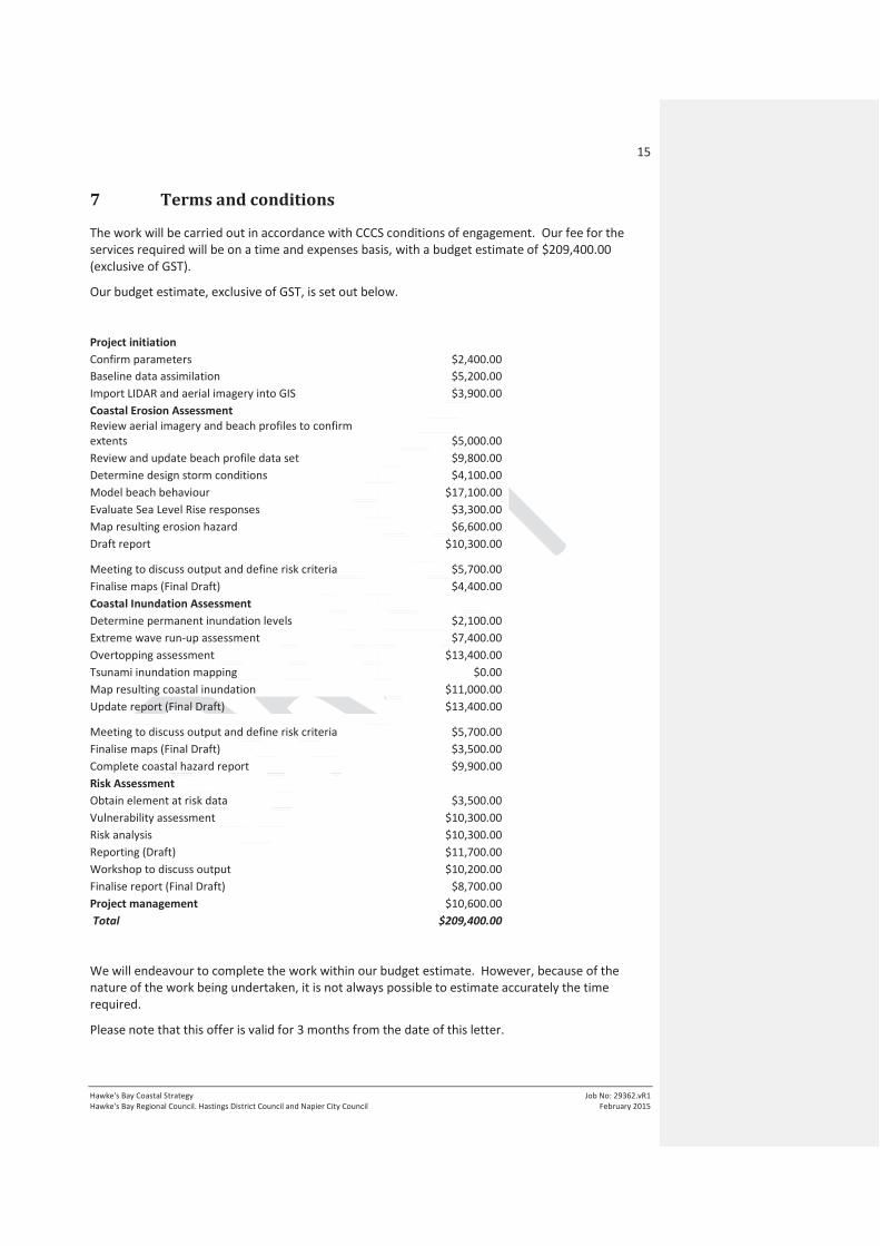
7 Terms and conditions
The work will be carried out in accordance with CCCS conditions of engagement. Our fee for the
services required will be on a time and expenses basis, with a budget estimate of $209,400.00
(exclusive of GST).
Our budget estimate, exclusive of GST, is set out below.
Project initiation
Confirm parameters $2,400.00
Baseline data assimilation $5,200.00
Import LIDAR and aerial imagery into GIS $3,900.00
Coastal Erosion Assessment
Review aerial imagery and beach profiles to confirm
extents $5,000.00
Review and update beach profile data set $9,800.00
Determine design storm conditions $4,100.00
Model beach behaviour $17,100.00
Evaluate Sea Level Rise responses $3,300.00
Map resulting erosion hazard $6,600.00
Draft report $10,300.00
Meeting to discuss output and define risk criteria $5,700.00
Finalise maps (Final Draft) $4,400.00
Coastal Inundation Assessment
Determine permanent inundation levels $2,100.00
Extreme wave run-up assessment $7,400.00
Overtopping assessment $13,400.00
Tsunami inundation mapping $0.00
Map resulting coastal inundation $11,000.00
Update report (Final Draft) $13,400.00
Meeting to discuss output and define risk criteria $5,700.00
Finalise maps (Final Draft) $3,500.00
Complete coastal hazard report $9,900.00
Risk Assessment
Obtain element at risk data $3,500.00
Vulnerability assessment $10,300.00
Risk analysis $10,300.00
Reporting (Draft) $11,700.00
Workshop to discuss output $10,200.00
Finalise report (Final Draft) $8,700.00
Project management $10,600.00
Total $209,400.00
We will endeavour to complete the work within our budget estimate. However, because of the
nature of the work being undertaken, it is not always possible to estimate accurately the time
required.
Please note that this offer is valid for 3 months from the date of this letter.

16
Hawke's Bay Coastal Strategy
Hawke's Bay Regional Council. Hastings District Council and Napier City Council
Job No: 29362.vR1
February 2015
8 Closure
This proposal has been prepared for the benefit of Hawke's Bay Regional Council. Hastings District
Council and Napier City Council . We look forward to working with you on this interesting project.
Tonkin & Taylor Ltd
Environmental and Engineering Consultants
Proposal prepared by: Authorised for Tonkin & Taylor Ltd by:
.......................................................... ...........................�.......�...............
Richard Reinen-Hamill Richard Reinen-Hamill
Tom Shand Project Director

Appendix A : Project Programme

ITEM 7 PROJECT TIMELINE AND SCOPE
Report to: Clifton to Tangoio Coastal Hazard Strategy Joint Committee
Report from: Coastal Hazard Management Strategy TAG
Lead author(s): Simon Bendall, Project Manager, EMS Limited
Meeting date: Friday 6th
March 2015
REASON FOR REPORT
1. Following receipt of the proposal from Tonkin and Taylor (“T&T”) to complete technical work, TAG
have updated the Project Timeline from the version presented at the last meeting of the Joint
Committee on 5 December, 2014.
2. TAG have also become aware of some uncertainty within the community on the deliverables
expected from this first stage of strategy development.
3. This paper provides an updated Project Timeline and provides some discussion to clarify Project
Scope.
DISCUSSION
Project Timeline Updates
4. The updated Clifton to Tangoio Coastal Hazard Strategy Project Timeline is attached to this report.
5. Importantly, the updated timeline does not change the end delivery date; rather, it incorporates
and aligns the proposed technical work stream with other work streams.
6. Additional changes to the timeline include the inclusion of TAG meeting dates as requested at the
last Joint Committee meeting, and some streamlining of project phasing.
Project Scope
7. The following key points are outlined to ensure clarity around project scope and to assist with
consistent community messaging:
a. The Coastal Hazard Strategy is being developed to provide a long term vision for the Clifton
to Tangoio coastline.
b. The strategy will be undertaken as a multistage process.
c. Stage One, due to be completed by the end of 2015, will focus on understanding the
coastal hazards issues facing this part of the coastline, quantifying the likelihood of each
hazard occurring and investigating the potential consequences. This will involve using the
most up to date science (including for example predicted sea level rise) and best practice
approaches for assessing coastal hazards risks.
d. Stage One of the Strategy should be viewed as the overarching ‘umbrella’ framework for
hazard management along the Clifton to Tangoio coastline. It will ensure cross boundary
consistency and cooperation when deciding on the most appropriate option for managing
hazards in the area.

6 March 2015 Coastal Hazard Strategy Joint Committee meeting Agenda Item 7
2
e. The scope of Stage One has been discussed in previous joint committee papers (refer to
Item 7 from 3 December Meeting). For clarity, it is emphasised that Stage One of this
project will not provide outcomes in terms of appropriate management and mitigation
options and costs for specific areas of the coastline.
f. Communities need to be clear that such discussion and decisions will occur in later stages
of the project, where the framework developed in Stage One will be used to identify and
test a range of options for the management or mitigation of risks for discrete areas of the
coast, and ultimately inform decision making on which option to implement.
RECOMMENDATION(S)
A. That the updated Project Plan for the Clifton to Tangoio Coastal Hazard Strategy be adopted.

Up
da
ted
6 M
arc
h,
20
15
Pro
ject
Tim
eli
ne
Ta
ng
oio
to
Cli
fto
n C
oa
sta
l H
aza
rd S
tra
teg
y 2
12
0
2
01
4
20
15
Sta
ge
On
e –
Est
ab
lish
Ris
k F
ram
ew
ork
Oct
No
v
D
ec
Ja
n
F
eb
Ma
r
Ap
r
Ma
y
Ju
n
Ju
l
Au
g
S
ep
Oct
No
v
D
ec
JC
TA
G
20
16
20
17
S
tag
e T
wo
: I
nd
ivid
ua
l C
ell
Pla
ns
S
tag
e T
hre
e :
Im
ple
me
nta
tio
n A
ctio
n P
lan
s /
Ca
pit
al
Wo
rks
Pro
gra
mm
e
15
th
24
th
6th
5
th
18
th
13
th
Pro
ject
In
itia
tio
n
Co
nsu
lta
tio
n S
tra
teg
y a
nd
Bri
efi
ng
of
Te
chn
ica
l E
xp
ert
s M
an
ag
em
en
t o
f T
ech
nic
al
Stu
die
s /
Ex
pe
rts
+ t
ech
nic
al
ass
ista
nce
fo
r Jo
int
Co
mm
itte
e
TAG
Pro
ject
Est
ab
lish
me
nt
an
d C
on
tex
t S
ett
ing
Ha
zard
Ev
alu
ati
on
R
isk
Ass
ess
me
nt
JC
Ide
nti
fica
tio
n o
f k
ey
sta
ke
ho
lde
rs
Co
nta
ct w
ith
sta
ke
ho
lde
rs a
nd
info
rma
tio
n e
xch
an
ge
C
on
sult
ati
on
wit
h s
tak
eh
old
er
gro
up
s
Community
10
th
13
th
9th
2n
d
4th
9th
23
rd
9th
2n
d
6th
1st
11
th
13
th
30
th
Recommendation to Councils / Iwi
Co
ast
al
Ero
sio
n A
sse
ssm
en
t
Co
ast
al
Inu
nd
ati
on
Ass
ess
me
nt
incl
ud
ing
Tsu
na
mi
Ris
k A
sse
ssm
en
t
Technical
Work
Stage One – Work Streams Meetings Future Stages

ITEM 8 STAKEHOLDER ENGAGEMENT
Report to: Clifton to Tangoio Coastal Hazard Strategy Joint Committee
Report from: Coastal Hazard Management Strategy TAG
Lead author(s): Simon Bendall, Project Manager, EMS Limited
Meeting date: Friday 6th
March 2015
REASON FOR REPORT
1. At the last meeting of the Joint Committee on 5 December 2014, some changes were requested to
the draft Stakeholder Engagement Plan as presented. These changes have been made.
2. TAG also wishes to provide an update on stakeholder engagement processes planned for the
coming months.
DISCUSSION
Stakeholder Engagement Plan
3. The updated Stakeholder Engagement Plan is attached to this paper.
4. This version has been updated to reflect changes requested at the last Joint Committee meeting.
5. To ensure consistency with best practice approaches to stakeholder engagement it has also been
reviewed by Regional Council staff who are currently training to receive accreditation from the
International Association for Public Participation.
6. The following key points are noted:
a. This Stakeholder Engagement Plan covers Stage One of Strategy development only. It is
recognised that later stages, involving decisions on specific coastal hazard responses, will
alter the level of engagement required and potentially the range of stakeholders with
interests.
b. This plan is intended to be a living document – the number of stakeholders and their level
of interests and involvement in Strategy development can change over time.
c. A new Section 7 - Review has been added to this version of the document. This is intended
to ensure that the Plan is responsive to changing interests and issues as strategy
development progresses. Future updates of this Plan will be presented to the Joint
Committee.
Stakeholder Engagement Processes
d. TAG are in the process of establishing a website specifically for this Strategy.
e. The website will be simple and inexpensive, similar to the site established for the
Heretaunga Plains Urban Development Strategy (www.hpuds.co.nz)
f. The benefits of a stand-alone website (rather than holding the information within one or
more of the Councils websites) are:

6 March 2015 Coastal Hazard Strategy Joint Committee meeting Agenda Item 8
2
i. Information is readily accessible without navigating through multiple layers of
Council information on existing websites.
ii. Better represents the cross-council approach being taken to Strategy development,
rather than hosting the information on one Council website.
iii. TAG are able to quickly and simply update information directly in one location.
g. TAG also wishes to advise that all stakeholders identified in the Stakeholder Engagement
Plan will receive a letter shortly following this Joint Committee Meeting advising them of
the process and directing them to the website for further information.
h. Follow up contact will be made in accordance with the Stakeholder Engagement Plan.
RECOMMENDATION(S)
A. That the updated Project Plan for the Clifton to Tangoio Coastal Hazard Strategy be adopted.

Tangoio to Clifton
Coastal Hazard Strategy 2120:
Stakeholder Engagement Plan
1. Purpose
This Stakeholder Engagement Plan will:
1. Identify the stakeholders to be involved as part of the first phase of the Tangoio to
Clifton Coastal Hazard Strategy (“Strategy”);
2. Outline the approach to be taken in engaging with each stakeholder / stakeholder
grouping and;
3. Programme consultation and engagement processes.
2. Engagement Objectives
This Stakeholder Engagement Plan seeks to achieve the following objectives:
1. All key stakeholders are identified and appropriately engaged in the first phase of
Strategy development;
2. Information from Stakeholders on coastal use and values is incorporated into the
Strategy;
3. Engagement is effective and efficient and tailored to stakeholders needs as far as
practicable, and;
4. Parties / The Strategy is adopted with maximum community buy-in and support;
3. Stakeholders
The table on the following page identifies key stakeholders / stakeholder groupings that may have
an interest in Strategy development. This is not a final or exhaustive list, and will evolve over time.
Stakeholders have been grouped into the following categories:
1. Individual Stakeholders: individual entities who have a specific or discrete set of interests in
the coastal environment such that engagement is appropriate on an individual basis.
2. Stakeholder Groups (Established): existing representative groups that can be engaged with
directly in strategy development.
3. Stakeholder Groups (To be established): proposed representative groups that would need
to be established part of this Plan.
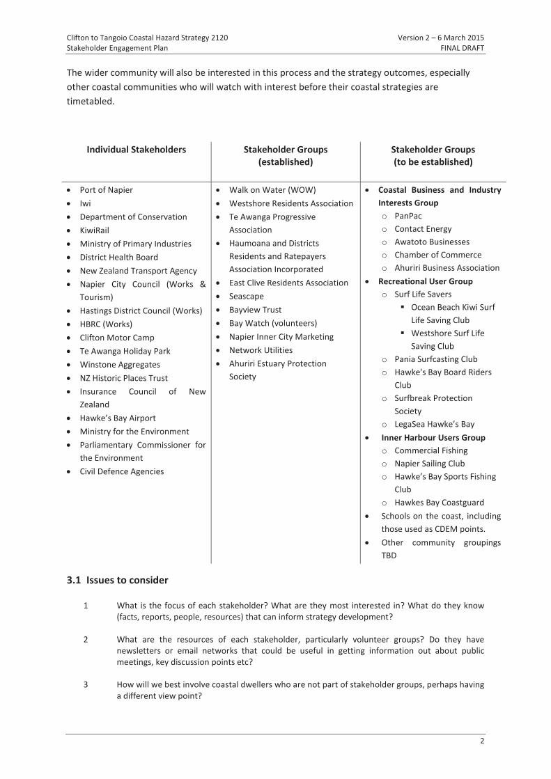
Clifton to Tangoio Coastal Hazard Strategy 2120 Version 2 – 6 March 2015
Stakeholder Engagement Plan FINAL DRAFT
2
The wider community will also be interested in this process and the strategy outcomes, especially
other coastal communities who will watch with interest before their coastal strategies are
timetabled.
Individual Stakeholders Stakeholder Groups
(established)
Stakeholder Groups
(to be established)
Port of Napier
Iwi
Department of Conservation
KiwiRail
Ministry of Primary Industries
District Health Board
New Zealand Transport Agency
Napier City Council (Works &
Tourism)
Hastings District Council (Works)
HBRC (Works)
Clifton Motor Camp
Te Awanga Holiday Park
Winstone Aggregates
NZ Historic Places Trust
Insurance Council of New
Zealand
Hawke’s Bay Airport
Ministry for the Environment
Parliamentary Commissioner for
the Environment
Civil Defence Agencies
Walk on Water (WOW)
Westshore Residents Association
Te Awanga Progressive
Association
Haumoana and Districts
Residents and Ratepayers
Association Incorporated
East Clive Residents Association
Seascape
Bayview Trust
Bay Watch (volunteers)
Napier Inner City Marketing
Network Utilities
Ahuriri Estuary Protection
Society
Coastal Business and Industry
Interests Group
o PanPac
o Contact Energy
o Awatoto Businesses
o Chamber of Commerce
o Ahuriri Business Association
Recreational User Group
o Surf Life Savers
Ocean Beach Kiwi Surf
Life Saving Club
Westshore Surf Life
Saving Club
o Pania Surfcasting Club
o Hawke's Bay Board Riders
Club
o Surfbreak Protection
Society
o LegaSea Hawke’s Bay
Inner Harbour Users Group
o Commercial Fishing
o Napier Sailing Club
o Hawke’s Bay Sports Fishing
Club
o Hawkes Bay Coastguard
Schools on the coast, including
those used as CDEM points.
Other community groupings
TBD
3.1 Issues to consider
1 What is the focus of each stakeholder? What are they most interested in? What do they know
(facts, reports, people, resources) that can inform strategy development?
2 What are the resources of each stakeholder, particularly volunteer groups? Do they have
newsletters or email networks that could be useful in getting information out about public
meetings, key discussion points etc?
3 How will we best involve coastal dwellers who are not part of stakeholder groups, perhaps having
a different view point?

Clifton to Tangoio Coastal Hazard Strategy 2120 Version 2 – 6 March 2015
Stakeholder Engagement Plan FINAL DRAFT
3
4. Stakeholder Mapping
A stakeholder mapping approach assists to tailor engagement processes at an appropriate level for
each stakeholder. The following matrix is used to divide stakeholders into 4 categories:
The approach to engagement for each category of stakeholder is summarised below:
Category Engagement Approach
Inform
Primary method of communications: Website, news media
Engagement Process:
Inform through media releases and coverage in community
newspapers (free)
Use website, and webpages of key organisations to inform
Add to newsletter distribution list if requested
Accept written comments / feedback if provided
Attend face to face meetings if requested by groups of people
Consult
Primary methods of communications: Written
correspondence/email, newsletter, website
Engagement Process:
Initial letter sent advising of process and directing to website
Added to newsletter distribution list
Invited in writing to attend any public meetings
Advised in writing of progress at milestone points in strategy
development and invited to submit written feedback / comments
Attend face to face meetings if requested by stakeholder
Strength of Interest
Infl
ue
nce
on
Su
cce
ss
Collaborate Involve
Consult Inform
Low High
Hig
h
Low

Clifton to Tangoio Coastal Hazard Strategy 2120 Version 2 – 6 March 2015
Stakeholder Engagement Plan FINAL DRAFT
4
Category Engagement Approach
Involve
Primary methods of communications: Written
correspondence/email, newsletter, website
Engagement Process:
Initial letter/email sent:
o advising of process;
odirecting to website, and
o inviting stakeholder to attend a face to face meeting to discuss
process of engagement
Added to newsletter distribution list
Advised in writing of progress at milestone points in strategy
development and invited to face to face meeting to discuss and
input to strategy development.
Collaborate
Primary methods of communications: Face to face meetings, Written
correspondence/email, newsletter, website
Engagement Process:
Initial letter sent:
o advising of process;
odirecting to website,
ohighlighting the stakeholders role in strategy development; and
o inviting stakeholder to attend a face to face meeting to discuss
process of engagement
Added to newsletter distribution list
Key inputs sought from stakeholder (via process to be agreed) at
regular intervals to inform strategy development
Feedback loop established with stakeholder to provide regular
process of feedback and response.
All meetings held with stakeholder are recorded through minutes
and agreed actions
5. Engagement Approach
The following presents an outline consultation strategy in relation to each of the identified
stakeholder groups.
All identified stakeholders will be at least ‘involved’ in the process from the outset. Groups may
move up and down the scale of being engaged as the process progresses and new stakeholders may
be identified as the process develops.
Media and the wider community will continue to be kept informed throughout the process.
It is critical to note that the following engagement approaches are for the first phase of strategy
development only. When later phases are initiated, involving decisions on specific responses to
coastal hazards risks in specific areas of the coast, a much more detailed approach for affected
communicates will be required and the engagement approach will be revised accordingly.

Clifton to Tangoio Coastal Hazard Strategy 2120 Version 2 – 6 March 2015
Stakeholder Engagement Plan FINAL DRAFT
5
5.1 Individual Organisations
Stakeholder Engagement
Approach
Port of Napier Collaborate
Iwi Collaborate
Department of Conservation Consult
KiwiRail Involve
Ministry of Primary Industries Involve
District Health Board Involve
New Zealand Transport Agency Involve
Napier City Council (Works & Tourism) Collaborate
Hastings District Council (Works) Collaborate
HBRC (Works) Collaborate
Clifton Motor Camp Consult
Te Awanga Holiday Park Consult
Winstone Aggregates Collaborate
NZ Historic Places Trust Inform
Insurance Council of New Zealand Collaborate
Hawke’s Bay Airport Consult
Ministry for the Environment Collaborate
Parliamentary Commissioner for the Environment Collaborate
Civil Defence Agencies Collaborate
5.2 Established Interest Groups
Stakeholder Engagement
Approach
Walk on Water (WOW) Consult
Westshore Residents Association Consult
Te Awanga Progressive Association Consult
Haumoana and Districts Residents and Ratepayers Association Incorporated Consult
East Clive Residents Association Consult
Bayview Trust Inform
Ahuriri Estuary Group (volunteers) Inform
Bay Watch (volunteers) Inform
Napier Inner City Marketing Inform
Network Utilities Inform
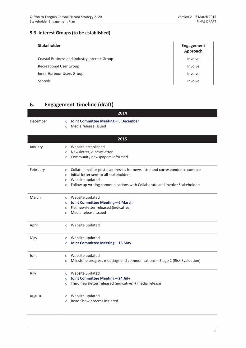
Clifton to Tangoio Coastal Hazard Strategy 2120 Version 2 – 6 March 2015
Stakeholder Engagement Plan FINAL DRAFT
6
5.3 Interest Groups (to be established)
Stakeholder Engagement
Approach
Coastal Business and Industry Interest Group Involve
Recreational User Group Involve
Inner Harbour Users Group Involve
Schools Involve
6. Engagement Timeline (draft)
2014
December o Joint Committee Meeting – 5 December
o Media release issued
2015
January o Website established
o Newsletter, e-newsletter
o Community newspapers informed
February o Collate email or postal addresses for newsletter and correspondence contacts
o Initial letter sent to all stakeholders
o Website updated
o Follow up writing communications with Collaborate and Involve Stakeholders
March o Website updated
o Joint Committee Meeting – 6 March
o Fist newsletter released (indicative)
o Media release issued
April o Website updated
May o Website updated
o Joint Committee Meeting – 15 May
June o Website updated
o Milestone progress meetings and communications – Stage 2 (Risk Evaluation)
July o Website updated
o Joint Committee Meeting – 24 July
o Third newsletter released (indicative) + media release
August o Website updated
o Road Show process initiated

Clifton to Tangoio Coastal Hazard Strategy 2120 Version 2 – 6 March 2015
Stakeholder Engagement Plan FINAL DRAFT
7
September o Website updated
o Joint Committee Meeting – 18 September
October o Website updated
November o Website updated
o Joint Committee Meeting – 13 November
o Milestone progress meetings and communications – Stage 3 (Risk Management
Strategy Framework)
o Fourth newsletter released (indicative) + media release
December o Website updated
o Strategy adopted
7. Review
This Plan shall be review quarterly by the Coastal Technical Advisory Group to confirm:
1. Whether any new stakeholders have been identified that should be added to this Plan
2. Whether the Engagement Approach for each stakeholder should be reviewed based on the outcome
of engagement to date and any requests from the stakeholder for more or less involvement; and
3. Whether the timeline outlined in Section 6 should be revised.
Should this Stakeholder Plan be updated the revised Plan shall be presented to the next Joint
Committee Meeting for endorsement.


![B-YS105 Conover - Lesson X [10], How to Make Dresses · DRESSMAKING BY ISABEL DENYSE CONOVER LESSON X HOW To MAKE DRESSES NEW YORK EDWARD J. CLODE 2010, 08 . Creative FREE TOTSTRTBUTTON](https://static.fdocuments.in/doc/165x107/5e7ed9833ab820348e1b9dda/b-ys105-conover-lesson-x-10-how-to-make-dressmaking-by-isabel-denyse-conover.jpg)