RAAF Base Williams, Pt Cook – Stage 3 / 4 Remediation and ...

Environmental Resources Management Australia
Level 1, 60 Leichhardt St, Spring Hill QLD 4004
Telephone +61 7 3839 8393 Facsimile +61 7 3839 8381
www.erm.com
REPORT Department of Defence
Stage 1 Environmental Investigation RAAF Base Tindal, Northern Territory June 2005
FOI 463/17/18 Item 4 Serial # 1
Page 80 of 4750

REPORT Department of Defence
Stage 1 Environmental Investigation RAAF Base Tindal, Northern Territory June 2005 Reference: 0028812 This report has been prepared in accordance with the scope of services described in the contract or agreement between Environmental Resources Management Australia Pty Ltd ACN 002 773 248 (ERM) and the Client. The report relies upon data, surveys, measurements and results taken at or under the particular times and conditions specified herein. Any findings, conclusions or recommendations only apply to the aforementioned circumstances and no greater reliance should be assumed or drawn by the Client. Furthermore, the report has been prepared solely for use by the Client and ERM accepts no responsibility for its use by other parties
For and on behalf of Environmental Resources Management Australia Approved by: Signed: Position: Dat: 22 June 2005
FOI 463/17/18 Item 4 Serial # 1
s47G
s47G
Page 81 of 4750

TABLE OF CONTENTS
1 INTRODUCTION 1
1.1 TERMS OF REFERENCE 1 1.2 BACKGROUND 1 1.3 OBJECTIVES 3 1.4 SCOPE OF WORK 3 1.4.1 DESKTOP SITE HISTORY REVIEW AND SITE RECONNAISSANCE 4 1.4.2 IDENTIFIED AREAS AND CHEMICALS OF CONCERN 4 1.4.3 CONCEPTUAL SITE MODEL 4 1.4.4 RISK ASSESSMENT 4 1.4.5 SAMPLING AND ANALYTICAL PLAN 5 1.5 LIMITATIONS 5
2 DATA QUALITY OBJECTIVES 7
3 SITE DESCRIPTION 8
3.1 LOCATION AND SITE FEATURES 8 3.2 CURRENT AND PROPOSED USE 9 3.2.1 CURRENT FACILITY ACTIVITIES 9 3.2.2 FUTURE USES 11 3.2.3 SURROUNDING LAND USES 11
4 SITE HISTORY REVIEW 12
4.1 REPORTS AND DATA REVIEWED 12 4.1.1 HLA, 2002/03, 2004 WATER QUALITY MONITORING SUMMARY 13 4.1.2 SKM ENVIRONMENTAL REPORTS (IER, 2000; EMP, 2001; EMS, 2005) 13 4.1.3 URS, 2002 FIRE STATION CONTAMINATION INVESTIGATION 16 4.2 DEVELOPMENT OF RAAF BASE TINDAL - OVERVIEW 17 4.2.1 AFFF MSDS AND TOXICOLOGICAL INFORMATION 17 4.3 AERIAL PHOTOGRAPH REVIEW 18 4.4 SITE HISTORY SUMMARY 19
5 LOCAL GEOLOGY, TOPOGRAPHY AND HYDROGEOLOGY20
5.1.1 GEOLOGY AND SOILS 20 5.1.2 SURFACE WATER AND DRAINAGE 20 5.1.3 HYDROGEOLOGY 21 5.1.4 GROUNDWATER USAGE AND RECORDS 21
6 SITE INSPECTION 24
6.1 SITE VISIT 24 6.2 INTERVIEWS 24 6.3 SITE RECONNAISSANCE 24 6.3.1 NT0064 - THE FIRE TRAINING AREA 25 6.3.2 NT0065 - FIRE STATION 26
FOI 463/17/18 Item 4 Serial # 1
Page 82 of 4750
6.3.3 NT0045 - ALDRIN USE – VARIOUS 27 6.3.4 NT0072 – 322CSS MAINTENANCE AREA 27 6.3.5 ADDITIONAL POTENTIAL CONTAMINATED SITES 29
7 DATA GAPS 31
7.1 DATA GAPS IN THE SITE HISTORY REVIEW 31 7.2 DATA GAPS IN THE SITE INSPECTION REVIEW 31
8 CONCEPTUAL SITE MODEL 32
8.1 INTRODUCTION 32 8.2 SOURCE - POTENTIAL AREAS OF ENVIRONMENTAL CONCERN (AEC) 32 8.3 RECEPTORS 34 8.4 EXPOSURE PATHWAYS 34
9 RISK ASSESSMENT 36
9.1 METHODOLOGY 36 9.1.1 CONSEQUENCE ANALYSIS 36 9.1.2 LIKELIHOOD 37 9.1.3 CALCULATION OF RISK LEVEL 37 9.2 RISK ESTIMATION 39 9.3 DISCUSSION 45 9.3.1 PRIMARY ASSUMPTIONS 45 9.3.2 OUTCOMES 45
10 SAMPLING AND ANALYTICAL PLAN 45
10.1 SOIL SAMPLING STRATEGY 45 10.1.1 SAMPLING PATTERN 45 10.1.2 SEDIMENT SAMPLING AND ASSESSMENT 45 10.1.3 GROUNDWATER SAMPLING 46 10.2 LABORATORY ANALYTICAL PROGRAM 46 10.2.1 SOIL ANALYSIS 46 10.2.2 SEDIMENT ANALYSIS 47 10.2.3 GROUNDWATER AND ANALYSIS QA/QC 47 10.3 QUALITY ASSURANCE AND QUALITY CONTROL 48 10.3.1 FIELD QUALITY ASSURANCE/ QUALITY CONTROL 49 10.4 ASSESSMENT CRITERIA 49 10.4.1 SOIL 49 10.4.2 GROUNDWATER 45 10.4.3 SEDIMENT 45
11 REFERENCES 1
FOI 463/17/18 Item 4 Serial # 1
Page 83 of 4750

LIST OF TABLES
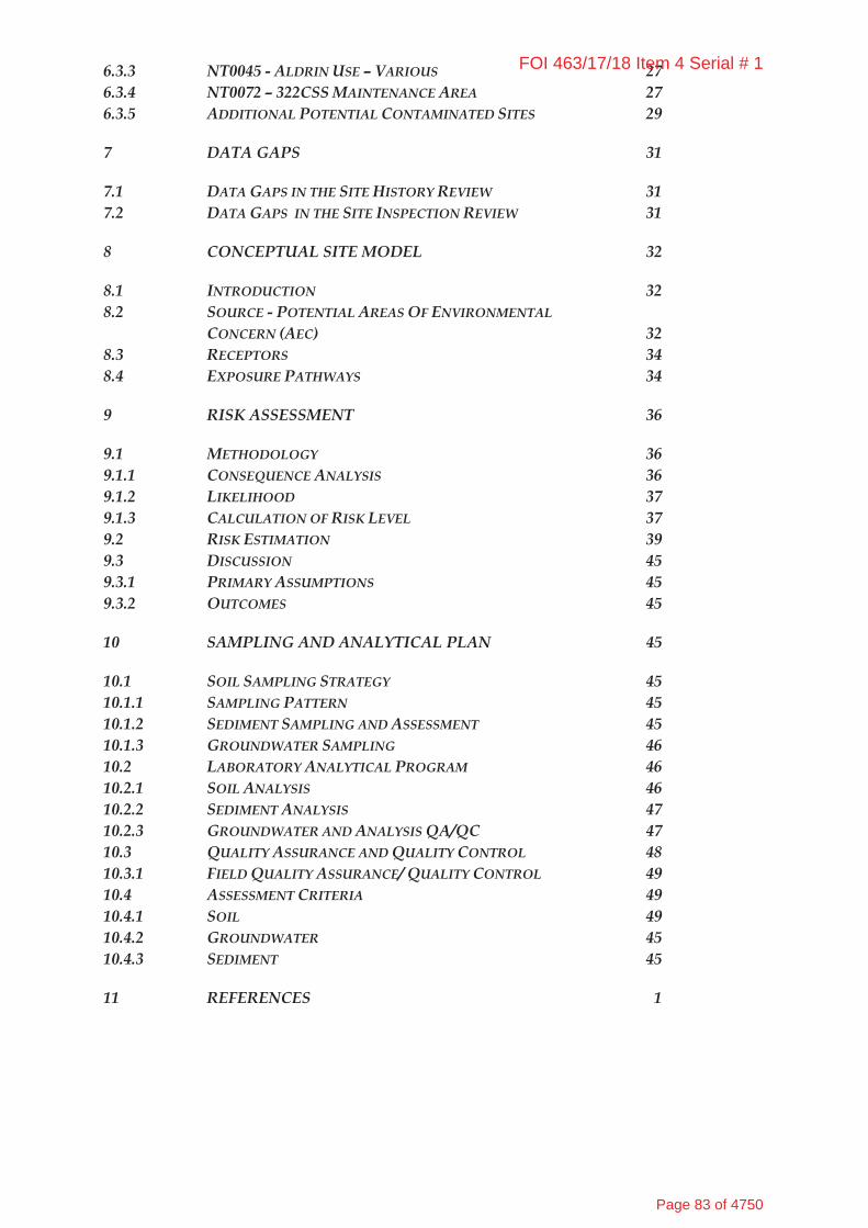
TABLE 1.1 DOD CONTAMINATED SITES REGISTER – RAAF BASE TINDAL SITES 2
TABLE 2.1 DATA QUALITY OBJECTIVES PROCESS AND REQUIREMENTS 7
TABLE 3.1 SITE FEATURES AND ACTIVITIES SUMMARY –SELECTED CSR SITES10
TABLE 4.1 AERIAL PHOTOGRAPHY INVESTIGATION SUMMARY 18
TABLE 5.1 LICENSED MONITORING BORES IN 2KM RADIUS OF SITE 22
TABLE 6.1 PERSONNEL INTERVIEWED DURING THE SITE INVESTIGATION 24
TABLE 6.2 DETAILS OF SITES FROM THE CSR – RAAF BASE TINDAL 25
TABLE 8.1 SUMMARY OF SOURCES - POTENTIAL AREAS AND CHEMICALS OF CONCERN 33
TABLE 8.2 SUMMARY OF POLLUTANT LINKAGES 35
TABLE 9.1 THREAT CRITERIA AND CONSEQUENCE SCALES 38
TABLE 9.2 LIKELIHOOD TABLE 39
TABLE 9.3 RISK LEVELS AND MANAGEMENT ACTIONS 39
TABLE 9.4 RISK ASSESSMENT FOR SOIL AND GROUNDWATER CONTAMINATION 40
TABLE 9.5 SUMMARY OF SITES RECOMMENDED FOR STAGE 2 SITE ASSESSMENT. 45
TABLE 10.1 PROPOSED SAMPLING PLAN FOR CSR SITES – RAAF TINDAL 46
TABLE 10.2 SUMMARY OF QA/QC PROCEDURES TO BE USED FOR SAP 48
LIST OF ANNEXES
ANNEX A FIGURES ANNEX B HISTORICAL AERIAL PHOTOGRAPHS AND RECORDS ANNEX C GROUNDWATER BORE RECORDS AND AQUIFER DETAILS ANNEX D SUMMARY WORKSHEET/ TABLE
FOI 463/17/18 Item 4 Serial # 1
Page 84 of 4750

ENVIRONMENTAL RESOURCES MANAGEMENT AUSTRALIA 0028812/FINAL/22 JUNE 2005
1
1 INTRODUCTION
1.1 TERMS OF REFERENCE
ERM was appointed by Department of Defence (Corporate Services and Infrastructure Group) to undertake a Stage 1 Contamination Investigation at RAAF Base Tindal. The base is located approximately 320km south east of Darwin and around 13km south east of the township of Katherine in the Northern Territory (Figure 1, Annex A).
The appointment is based on ERM proposal dated 4 February 2005; the Terms of Engagement set out in ERM’s Panel Agreement with Defence and the letter of confirmation from Defence dated 18 February 2005. The works were authorised under Defence Purchase Order 4500424265.
The Stage 1 Contamination Investigation has been undertaken in general accordance with the National Environment Protection (Assessment of Site Contamination) Measure 1999” or NEPM Guidelines, and as such comprise a desk top review of relevant information together with site reconnaissance and interviews with key staff and personnel.
A risk assessment of these findings has been conducted in accordance with defence protocols and a proposed Sampling and Analytical Plan (SAP) has been developed to allow future vertical and lateral delineation of identified/potential contamination sources at the site
1.2 BACKGROUND
The potential for significant environmental impact to arise as a result of activities previously or currently undertaken on DoD sites represents a risk to the environment and Defence operations. These risks have typically been identified within Environmental Management Plans developed for DoD sites. In response, programs of assessment and monitoring have been progressively rolled out across selected sites to proactively manage these risks and allow early intervention where significant issues are identified or confirmed.
A strategic, qualitative risk-based approach to the management of contaminated Defence land has been adopted by the Directorate of Environmental Stewardship (DES). This has resulted in the listing of some 1400 sites on the Defence Contaminated Sites Register (CSR), with a proportion identified as presenting a high potential risk to human health and/ or the environment. A number of high-risk sites have been identified at RAAF Base Tindal. The complete list of 35 entries on the CSR for Tindal are presented below, with high-risk sites highlighted.
FOI 463/17/18 Item 4 Serial # 1
Page 85 of 4750
ENVIRONMENTAL RESOURCES MANAGEMENT AUSTRALIA 0028812/FINAL/22 JUNE 2005
2
Table 1.1 DoD Contaminated Sites Register – RAAF Base Tindal Sites
CSR Number
Site Details Risk/ Priority
NT0045 Historical insecticide use* High
NT0064 Fire training Area* High
NT0065 Fire station* High
NT0046 Landfill (no longer used)** Medium
NT0047 Landfill (green & other waste) Medium
NT0048 Waste disposal near old hangar area Medium
NT0049 Disposal near SAR Medium
NT0050 waste disposal near Ordnance preparation area Medium
NT0051 Hornet aircraft & tactical unmanned aerial vehicle burial site Medium
NT0052 Ordnance & explosive detonation are near quarry Medium
NT0053 UST Motor Transport Operation facility Medium
NT0054 UST Canteen Medium
NT0061 Sewage treatment ponds Medium
NT0066 Ground Equipment maintenance workshops Medium
NT0069 Katherine Airport Medium
NT0070 Battery charging building Medium
NT0071 Old Hangar Area Medium
NT0072 322 General Engineering Section workshops* Medium
NT0076 Fuel farm 1** Medium
NT0079 AST Serco depot Medium
NT0055 Septic 1 near RAAF Air movements Low
NT0056 Septic 2 east of old hangar area Low
NT0057 Septic 3 near SAR Low
NT0058 Septic 4 -6 at large Ordnance loading apron Low
NT0059 Septic 7 at ordnance preparation area Low
NT0060 Septic 8 near golf course Low
NT0062 Sewage drying area (adjac to ponds) Low
NT0063 Sewage sludge drying area (horse paddocks) Low
NT0067 Washpoint catering area Low
NT0068 Ordnance Loading areas Low
NT0073 75 Squadron workshops/hangars Low
NT0074 Photographic area Low
NT0075 Machine gun beryllium waste Low
NT0077 Fuel farm 2** Low
NT0078 AST near medical waste incinerator Low
* CSR Sites selected as priority sites for this assessment. Remaining sites were not assessed here.
** Sites not originally selected for assessment, but highlighted as potential issues during site visit.
Source: NT/K CSIG
FOI 463/17/18 Item 4 Serial # 1
Page 86 of 4750

ENVIRONMENTAL RESOURCES MANAGEMENT AUSTRALIA 0028812/FINAL/22 JUNE 2005
3
This Stage 1 Contamination Investigation is component of the Defence risk management process and is required to provide an initial risk assessment of the potential hazards posed to human health and the environment from possible contamination present at the high risk sites identified within the base. An additional medium risk site flagged by request of the Regional Environmental Officer was also included in the assessment.
1.3 OBJECTIVES
This Stage 1 Contamination Investigation project has been designed to fulfil the following major project outcomes:
Initial desk based risk assessment of potential contamination hazards to human health and the environment, based on the Site History Review for the three (3) high risk CSR sites and the medium risk Maintenance Area 322CSS, and where possible identify any additional areas of concern or issues, and
Proposed Stage 2 Sampling and analysis Plan based on the Risk Assessment outcomes, to enable the characterisation of the vertical and horizontal extent of contamination at the site.
Any additional major issues identified during the site visit were also to be considered if necessary, however the CSR sites were the priority areas to be assessed.
1.4 SCOPE OF WORK
The investigations were required to provide more accurate information towards developing a portfolio risk profile associated with current and legacy contaminated land issues across the Defence land holding.
The general scope of work of this assessment included the following:
Desktop Site History Review and Site Reconnaissance;
Identification of Areas and Contaminants of Concern;
Development of Conceptual Site Model;
Risk Assessment for identified areas; and
Sampling and Analysis Plan
FOI 463/17/18 Item 4 Serial # 1
Page 87 of 4750

ENVIRONMENTAL RESOURCES MANAGEMENT AUSTRALIA 0028812/FINAL/22 JUNE 2005
4
1.4.1 Desktop Site History Review and Site Reconnaissance
The objectives of the desktop Site History Review were to provide a site history review that identifies potentially contaminating activities that have been performed on the site in the past or are currently being performed on the site and describe the potential Areas of Environmental Concern (AECs) and associated chemicals of concern (CoCs).
The desktop Site History Review included the following:
Review of previous investigations and reports related to the site;
Review of historical files, records and aerial photographs related to the site;
Interviews with previous owners/ personnel at the site and relevant persons;
Review and summary of relevant State/ Local Government records and available information; and
Data assessment
1.4.2 Identified Areas and Chemicals of Concern
The aim of this stage of assessment was to identify potential chemicals of concern (CoC) at the four (4) CSR sites and identify any additional areas of environmental concern (AEC) based on the previous use of the site and the conditions observed during the site visit.
1.4.3 Conceptual Site Model
The development of a conceptual site model was included in the Stage 1 Contamination Assessment in order to better describe and identify potential sensitive environmental and human receptors and associated potential exposure pathways.
1.4.4 Risk Assessment
The Risk Assessment component was incorporated into the assessment, in accordance with the Department of Defence Risk Management Framework. The Risk Assessment process includes the following components:
Consequence Analysis;
Likelihood ;
Calculation of Risk Level;
FOI 463/17/18 Item 4 Serial # 1
Page 88 of 4750

ENVIRONMENTAL RESOURCES MANAGEMENT AUSTRALIA 0028812/FINAL/22 JUNE 2005
5
Outcomes; and
Discussion.
1.4.5 Sampling and Analytical Plan
The objective of the SAP was to provide a sampling and analysis plan for consideration by the Department of Defence for a future Stage 2 contaminated site assessment.
The scope of work for the SAP includes:
Descriptions of the proposed sampling and analytical scope;
The basis of the proposed sampling strategy; and
Summary of outline specifications and guidance for intrusive works including assessment criteria and other relevant information.
1.5 LIMITATIONS
The findings of this report are based on the Scope of Work outlined in ERM Proposal dated 18 February 2005. ERM performed the services in a manner consistent with the normal level of care and expertise exercised by members of the environmental auditing profession. No warranties, express or implied, are made.
Subject to the Scope of Work, ERM’s assessment is limited strictly to identifying typical environmental conditions associated with the subject property and does not evaluate structural conditions of any buildings on the subject property, nor any other issues. Although normal standards of professional practice have been applied, the absence of any identified hazardous or toxic materials on the subject property should not be interpreted as a guarantee that such materials do not exist on the site.
This assessment is based on data review and site inspection conducted by ERM personnel described in the report. No sampling or analyses of any media were undertaken under this appointment. All conclusions and recommendations made in the report are the professional opinions of the ERM personnel involved with the project and, while normal checking of the accuracy of data has been conducted, ERM assumes no responsibility or liability for errors in data obtained from regulatory agencies or any other external sources, nor from occurrences outside the scope of this project.
ERM is not engaged in environmental auditing and reporting for the purpose of advertising sales promoting, or endorsement of any client interests, including raising investment capital, recommending investment decisions, or other publicity purposes. The client acknowledges that this report is for the exclusive use of the client, its representatives and advisers and any investors,
FOI 463/17/18 Item 4 Serial # 1
Page 89 of 4750

ENVIRONMENTAL RESOURCES MANAGEMENT AUSTRALIA 0028812/FINAL/22 JUNE 2005
6
lenders, underwriters and financiers who agree to execute a reliance letter (a copy of which can be supplied upon request), and the client agrees that ERM’s report or correspondences will not be, except as set forth herein, used or reproduced in full or in parts for such promotional purposes, and may not be used or relied upon in any prospectus or offering circular.
FOI 463/17/18 Item 4 Serial # 1
Page 90 of 4750

ENVIRONMENTAL RESOURCES MANAGEMENT AUSTRALIA 0028812/FINAL/22 JUNE 2005
7
2 DATA QUALITY OBJECTIVES
The amount, nature and quality of the data are determined by the data quality objectives. Consideration of the Data Quality Objectives (DQO) must be given to ensure the data gathered is sufficient to characterise potential contamination at the site and enable [adequate] further assessment of the potential human health and environmental risk posed by contamination at the site. In establishing Data Quality Objectives for this Stage 1 assessment the process shown in Table 3.1 has been applied.
Table 2.1 Data Quality Objectives Process and Requirements
DQO Step
Action Requirements
Step 1. State the Problem
Define the problem; identify the project team; examine budget, schedule (Potential contamination risks to human health and the environment - Stage 1 contamination investigation)
Step 2. Identify the Decision
State decision; identify study question; define alternative actions. (Site history Review to further characterise potential areas and contaminants of concern, develop conceptual site model to assess plausible exposure pathways and receptors)
Step 3. Identify the Inputs to the Decision
Identify information needed for the decision, information sources and basis for Action Level, sampling/analysis method. (Previous assessments, interviews, historical info, government agency records, Defence data)
Step 4. Define the Boundaries of the Study
Specify sample characteristics; define spatial/ temporal limits, units of decision making. (CSR listed sites and associated areas and other potentially contaminated areas, based on site history)
Step 5. Develop a Decision Rule
Define statistical parameter (mean, median); specify Action Level; develop logic for action. (Identification of potential risks to human health and the environment and specific locations requiring sampling and chemicals that need to be analysed, based on site history, previous water quality investigations and reviewed data)
Step 6. Specify Tolerable Limits on Decision Errors
Set acceptable limits for decision errors relative to consequences, including health effects & costs. (Anecdotal evidence supported by site inspections and Defence records, identify gaps in data)
Step 7. Optimise the Design for Obtaining Data
Select resource-effective sampling and analysis plan that meets the performance criteria. (Targeted and grid sampling design for SAP based on site history etc)
Source: US EPA, Quality Assurance – QA/G-4, Guidance for the Data Quality Objectives Process
FOI 463/17/18 Item 4 Serial # 1
Page 91 of 4750

ENVIRONMENTAL RESOURCES MANAGEMENT AUSTRALIA 0028812/FINAL/22 JUNE 2005
8
3 SITE DESCRIPTION
3.1 LOCATION AND SITE FEATURES
The RAAF Base Tindal is located approximately 320km south east of Darwin and around 13km south east of the township of Katherine in the Northern Territory. The base covers an estimated area of 122 square kilometres, however it is understood that much of this area is covered by mixed Eucalypt bushland and open forest and less than one twentieth of this area contains structures and significant paving and development. RAAF Base Tindal contains the following main site features and structures:
Married Quarters (north side, approximately 3km south of the Stuart Highway)
Messes and football oval (south of the married quarters)
Frontline Canteen & Service Station (west of the married quarters)
Golf Course (south-west of the married quarters)
Vehicle Maintenance Area, Hazardous Materials Storage and Dog Complex (east of the golf course, south of married quarters)
Ordnance Storage (West of Golf course)
Ordnance Loading Aprons (either side of former Stuart Highway)
Fuel Farm No. 2
Fuel Farm No. 1
RAAF Air movements
Civilian Airport
Fire Brigade and Search and Rescue Section
Fire Training Area
Sewage Treatment Plant & Horse Paddock (effluent irrigation area, far south west of site)
75 Squadron workshops and Fuel Farm No. 1 and QA/QC labs
Other ordnance preparation and storage areas
There are a total of 35 sites currently listed on the contaminated sites register (CSR) for RAAF Tindal Base. Defence broadly assessed three (3) of these sites
FOI 463/17/18 Item 4 Serial # 1
Page 92 of 4750
ENVIRONMENTAL RESOURCES MANAGEMENT AUSTRALIA 0028812/FINAL/22 JUNE 2005
9
as high risk and having been identified as potentially contaminated sites. The three areas include:
the Fire Training Area (CSR No. NT0064);
Fire Station (CSR No. NT0065); and
the use of Aldrin insecticide prior to 1988 (CSR No. NT0045).
In addition to these the following medium risk areas were highlighted by Defence personnel and/ or identified during the site inspection:
322CSS Maintenance Area (CSR NT0072)
Fuel Farm 1 (CSR NT0076)
Fuel Farm 2 (CSR NT0077)
Former Landfill (CSR NT0046) and various burial sites.
A summary of the Sites assessed here and the activities conducted in these areas is provided in Table 3.1 below.
3.2 CURRENT AND PROPOSED USE
3.2.1 Current Facility Activities
RAAF Base Tindal currently operates as a joint civil-military airfield employing approximately 600 military and civilian personnel. The primary role of RAAF Base Tindal is to provide an operational base for 75 Squadron which forms part of the Air Force’s Tactical Fighter Force.
RAAF Base Tindal as it exists today was first established in 1987 and is currently under the control of 322 Combat Support Wing (322 CSW). The Hill 202 Radar Facility, also established in 1987 is located approximately 4 km east of Tindal. The current layout of Tindal is shown in Figure 2, Annex A.
There are a number of activities undertaken at Tindal which include (but are not limited to) the following:
Ordnance preparation, storage and assembly;
Refuelling of vehicles and aircraft;
Aircraft maintenance, washing and painting;
Fuel testing;
Light engineering works (vehicle maintenance, welding, aircraft engine works and body works, including painting);
FOI 463/17/18 Item 4 Serial # 1
Page 93 of 4750

ENVIRONMENTAL RESOURCES MANAGEMENT AUSTRALIA 0028812/FINAL/22 JUNE 2005
10
Security, including police dog training;
Radar communications;
Medical facilities;
Catering;
Photography of aircraft and personnel (and photo processing);
Fire fighting services;
Accommodation;
Ground defence training;
Search and rescue (SAR) undertaken by contractors Lloyds;
Lease of land to Frontline who run a canteen and service station for private use by Base personnel and the public;
Lease of land to Katherine Town Council who manage the Katherine Airport; and
Air movements of military passengers and cargo.
Table 3.1 Site Features and Activities Summary –Selected CSR Sites
CSR Site Features Current Activities Undertaken Fire Station NT0065
Fire truck and Vehicle Storage Fire station building and office Bitumen covered hardstand area
Fire equipment testing and cleaning Administration, theoretical training exercises and Vehicle wash down
Fire Training Area NT0064
Bunded lined fire pit Evaporation ponds Cleared open exercise ground and practice equipment
Practical fire training exercises (extinguishing various fuel fires)
322CSS Maintenance Area
NT0072
Fuel supply building, Special Purpose Vehicles workshop, truck maintenance workshop, Ground Support Equipment workshop and office buildings
Light engineering, servicing and general maintenance of trucks, special purpose vehicles and ground support equipment.
1. CSR site NT0045 relating to Aldrin use at various locations across the base has not been included here as it does not relate directly to a site/ feature and current activity.
FOI 463/17/18 Item 4 Serial # 1
Page 94 of 4750

ENVIRONMENTAL RESOURCES MANAGEMENT AUSTRALIA 0028812/FINAL/22 JUNE 2005
11
3.2.2 Future Uses
It is understood the Base is likely to undergo redevelopment and expansion as a priority Defence establishment. The site is therefore likely to continue to be used in its current form. It should be noted that although RAAF Tindal is considered an operational Defence facility, and may be categorised as a commercial/ industrial land use, the presence of Defence accommodation and residential housing on the base constitutes a potentially more sensitive land use, and this should therefore be taken into account.
3.2.3 Surrounding Land uses
The surrounding land use can be summarised as follows:
The site is bounded by the Stuart Highway to the north, with grazing and rural/residential land to the north ( including Jarridale Station);
Partially disturbed bushland rural land and mango farms to the east and the Township of Katherine 13km east-north east.
Cutta Cutta Caves National Park to the south
Grazing land and a quarry, from which blue metal road base is mined, to the west.
FOI 463/17/18 Item 4 Serial # 1
Page 95 of 4750

ENVIRONMENTAL RESOURCES MANAGEMENT AUSTRALIA 0028812/FINAL/22 JUNE 2005
12
4 SITE HISTORY REVIEW
The site history review prepared by ERM was based on the following:
1) interviews with current site managers and personnel
2) review of previous and current activities
3) a historical title information (where available);
4) a review of DoD records on the site;
5) a review of historical aerial photography over the past 40-50 years;
6) a review of groundwater records;
7) a review of a preliminary water investigations on the site;
8) A review of Office of Environment and Heritage notices under the Environmental Hazardous Chemicals Act (1985) and the Contaminated Land Management Act (1997).
9) Site visit/ inspection
4.1 REPORTS AND DATA REVIEWED
An electronic copy of documents and previous reports relevant to RAAF Base Tindal were provided by the NT/K CSI group. This data included some 653 files (76 folders) containing correspondence, reports, letters, e-mails/ communications, notes and information relevant to contamination issues and development at RAAF Base Tindal. The information reviewed included the following reports, considered particularly relevant to this assessment:
HLA- Envirosciences Pty Ltd, RAAF Base Tindal, Water Quality Investigation 2002-2003
HLA- Envirosciences Pty Ltd, RAAF Base Tindal, Water Quality Investigation 2003-2004
Sinclair Knight Merz, Environmental Management Plan for RAAF Base Tindal, 19th July 2001, Ref. DNR04674
SKM, Phase 1: Initial Environmental Review (IER) for RAAF Base Tindal, 17 August 2000
SKM, Phase 3 Environmental Management Plan for RAAF Base Tindal, Final, DR04674, 19 July, 2001
SKM, Phase 3 Environment and Heritage Strategy/Implementation Plan for RAAF Base Tindal, Draft 2 DR04674, 16 May, 2001
FOI 463/17/18 Item 4 Serial # 1
Page 96 of 4750

ENVIRONMENTAL RESOURCES MANAGEMENT AUSTRALIA 0028812/FINAL/22 JUNE 2005
13
SKM, EMS Development Phase 1 Environmental Review Report RAAF Base Tindal, Draft, 28 January 2005
URS, Contamination Investigation, Fire Testing Area, RAAF Base Tindal, URS, 14 June 2002
4.1.1 HLA, 2002/03, 2004 Water Quality Monitoring Summary
Water Quality investigations carried out by Tropical Water Solutions (a member of HLA) in 2002, 2003 and 2004 reported the following:
Water quality monitoring was conducted for the pre-wet season (January 2003) and post-wet season (April 2003)
Groundwater interaction with Tindal Creek greatly affected water quality results (indicated by salinity and pH)
Detectable uranium concentrations were present at three sampling sites along Tindal Creek
Slightly elevated levels of Chromium <3.9ug/L, Uranium (<0.84ug/L) and Copper (<2.1ug/L) were reported in samples from all three sites (however significant variations were observed between wet and dry seasons, and considered background/natural levels).
No organochlorine or organophosphate pesticides or petroleum hydrocarbons were observed above detection limits in samples analysed.
Further testing including the analysis of radium 228 and 226, potassium 40 and possibly gross and particles recommended, unless additional background information is obtained to suggest its not required.
4.1.2 SKM Environmental Reports (IER, 2000; EMP, 2001; EMS, 2005)
Sinclair Knight Mertz have prepared a number of reports in relation to environmental management, and environmental management systems at RAAF Base Tindal. The relevant information gained from these reports can be summarised as follows:
The results of an Initial Environmental Review (IER) provided the background for the development of a three phase scope of work to review the existing Environment Management Plan (EMP) for RBT and formulate a more current Plan relevant to the present and foreseeable activities undertaken at Tindal. The SKM IER, 2000 reported the following details relating to ‘Pollution and Contamination’ at Tindal:
“Aldrin was used as an insecticide at RBT until its use was stopped in 1988. Apart from such historical events, other practices which have may have resulted in soil and/or groundwater contamination at RBT include:
FOI 463/17/18 Item 4 Serial # 1
Page 97 of 4750
ENVIRONMENTAL RESOURCES MANAGEMENT AUSTRALIA 0028812/FINAL/22 JUNE 2005
14
uncontrolled dumping of rubbish in various landfill sites;
leaks from underground fuel storage tanks;
fuel and chemical spills from inappropriate handling or storage;
discharge of contaminated wastewater;
burial of crashed aircraft;
operation of Base sewage treatment plant, use of septic tanks, drying of sewage sludge on the ‘horse paddock’ and the presence of the old Base sewerage system;
detonation of ‘weeping’ or expired ordnance; and
fire training.
“No soil testing has been undertaken at RAAF Base Tindal (RBT) since its development, except for a number of environmental assessments carried out between 1996-1999 by Fluor Daniel and Dames and Moore. They assessed soil and groundwater contamination due to fuel leaks from underground storage tanks at the Motor Transport Operations Facility (MTOPS) and the Frontline canteen. In 1997, hydrocarbon product was found to have leaked from one of the tanks in the MTOPS at RBT (also called the General Engineering Section). To minimise the potential for environmental and human health impact, the underground fuel storage tanks (USTs) in the area were removed and replaced with new tanks. As the USTs at the Frontline service station were of the same age, they were also removed. Dames and Moore (1999) undertook the UST replacement works and validation sampling.
Validation samples were collected from the tank excavations and soil/fill material temporarily stockpiled from the excavations prior to disposal to a landfill at the base. Fifteen samples were collected from MTOPs, twenty-two from Frontline and seven from the stockpile. Three groundwater samples were also collected. Marginal exceedance of adopted TPH guidelines was noted for soils surrounding the USTs at both the MTOPs and the Frontline service station. Total petroleum hydrocarbon (C10-C14) was found in a groundwater bore near the MTOPs facility at a concentration of 3.7 mg/L, which exceeds the adopted Dutch Intervention Level of 0.6 mg/L. Benzene was also found in this bore at 2.0 mg/L, which is greater than the Dutch Intervention Level of 0.03 mg/L.
The NEPM Groundwater Investigation Levels referred to in Schedule B(1) do not include investigation levels for total petroleum hydrocarbons, however freshwater and drinking water standards are provided for benzene. The benzene investigation level for Freshwater has been set at 0.3mg/L and the Drinking Water Investigation Level at 0.000001mg/L. The levels found in groundwater at the Frontline service station (of <2.0mg/L) exceed both these criteria. Soil Health Investigation Levels (HIL’s) in the NEPM are set for various fractions of hydrocarbons, including C16-C35 aromatics and C16-C35 aliphatics and are therefore are directly comparable to soil analytical results described above.
FOI 463/17/18 Item 4 Serial # 1
Page 98 of 4750

ENVIRONMENTAL RESOURCES MANAGEMENT AUSTRALIA 0028812/FINAL/22 JUNE 2005
15
The soil contamination was not remediated based on commercial/industrial use of the area and the fact that it is overlain with 150-200mm of concrete paving. This is not considered to be onerous since it is unlikely that any potential receptors (ie. users of the service station or wildlife) would come into contact with the contaminated soils.
Groundwater was not remediated, although a recommendation was made in Dames and Moore’s validation report (October, 1999) to ‘undertake on-going sampling of existing monitoring wells on a six-monthly basis until a reduction in groundwater contamination is noted’. No results were found on file to indicate this is being undertaken, however it could easily be incorporated in the current groundwater-monitoring program at Tindal.
Groundwater is tested at RBT on a monthly basis by Asset Services for its suitability to drink. Microbiological indicators are generally the only parameters tested for in the water. Petroleum hydrocarbons are tested for in groundwater from selected bores on a six monthly basis. All laboratory reports from the testing are forwarded to DEO – Tindal for their records.
Results from the sampling round in January 2000 showed hydrocarbon contamination to be present in bores located at the Flightline Diner, near Air Movements and at the Sewage Treatment Plant (bores 6, 9, and 10 respectively). Asset Services produce a monthly report on water testing results but no interpretation of the data is made. If an abnormal result is obtained (for example, presence of E. coli in groundwater), the bore is re-sampled. At this stage no further action is taken in the event of contamination being found.”
The 2001 EMP provided an Environment and Heritage Strategy including strategic action plans and Implementation plans for the following issues:
Fire Management,
Waste Management,
Weed and Feral Animal Management,
Hazardous Materials Management,
Soil and Water Management,
Cultural Heritage,
Social and Community Issues
Fuel Management,
Mosquito Control and
Habitat Management.
FOI 463/17/18 Item 4 Serial # 1
Page 99 of 4750

ENVIRONMENTAL RESOURCES MANAGEMENT AUSTRALIA 0028812/FINAL/22 JUNE 2005
16
Fuel management action plans included the implementation of emergency response procedures, and fuel reconciliation records.
Waste management procedures to be developed included procedures for the disposal of aircraft wreckage on site; the segregation of waste streams and the broader use of waste interceptors, traps and evaporation ponds across the base.
Hazardous materials management recommendations included the development of emergency response plans, the establishment of an incident register and maintaining hazardous materials registers.
The SKM Phase 1 Environmental Review Report for the EMS Development (January 2005) identified existing and potential environmental issues at RAAF Base Tindal and recommendations based on environmental risks.
The SKM EMS Development report identified the storage and handling of fuels, hazardous chemicals and wastes as the major potential sources of contamination at the base.
4.1.3 URS, 2002 Fire Station Contamination Investigation
URS conducted an investigation in June 2002 to assess whether contamination had occurred at the Fire Station from periodic testing of equipment. The results of the URS investigation can be summarised as follows:
It was estimated that approximately 104,000L per year of waste water containing residual Aqueous Fire Fighting Foam was released into the storm water drain and the evaporation pond.
Four (4) surface water samples and three (3) soil samples were collected and analysed for a range of hydrocarbons, heavy metals and surfactants.
Elevated levels of surfactants (<21mg/L), hydrocarbons (<1.25mg/L C10-C35) and chromium (<0.093kg/L) were detected in the evaporation pond, west of the property.
It was assessed that the contaminants were likely to have resulted from vehicle/ equipment wash down.
Soil/ sediment analysis results were generally below adopted guideline levels or below laboratory detection limits (however soils were not analysed for surfactants or AFFF components).
The potential for off-site contamination exists, which would be in contravention of the Waste Management and Pollution Control Act, 1998.
Recommendations were made to reduce the production of waste-waster and to install an interceptor trap.
FOI 463/17/18 Item 4 Serial # 1
Page 100 of 4750
ENVIRONMENTAL RESOURCES MANAGEMENT AUSTRALIA 0028812/FINAL/22 JUNE 2005
17
4.2 DEVELOPMENT OF RAAF BASE TINDAL - OVERVIEW
The area of land now incorporated into RAAF Base Tindal was known as Carson’s Airfield. It is understood that construction at Tindal began during WWII and it was completed in 1944 by an element of the Victorian Country Roads Board (IER,2000).
The construction at Tindal began during WWII by an American engineer regiment and it was completed in 1944 (IER, 2000). The small airfield was originally constructed for limited exercises and civilian use, and did not contain any aircraft squadrons during WWII. When initially constructed in 1944 it is understood that the small airfield was originally used for limited exercises and civilian use and did not contain any aircraft squadrons during WWII.
Further reconstruction and extension works were carried out in the late 1950s and 1960s by the RAAF’s No 5 Airfield Construction Squadron to provide a backup airfield to Darwin. From 1963 to 1970, Tindal was further upgraded for use as an airfield for excesses and civilian use, and was used as a “bare base”. There was significant upgrading and expansion during the 1980s and in 1987 RAAF Base Tindal was established.
The Hill 202 Radar Facility is located approximately 4 km east of RBT. It was established at the same time as RBT. Its purpose is to provide Air Traffic Control radar and communications.
The primary role of RAAF Base Tindal is currently to provide a home for 75 Squadron, which forms part of the Air Force’s Tactical Fighter Force.
4.2.1 AFFF MSDS and Toxicological Information
The Aqueous Fire Fighting foam (AFFF) used at Tindal up until 2003, was classed as either 3% or 6% 3M. The material safety data sheets (MSDS) describes 3M as containing the following ingredients:
Water (70<80%)
Diethylene Glycol Butyl Ether (10<30%)
Dye (<5%)
Synthetic Detergents (<5%)
Fluruoalkyl surfactants, (<5%) and
Residual organic fluurochemicals (not determined)
Toxicological information indicates that the organic fluorochemicals have the potential to be absorbed and remain in the human body for long periods of time and may accumulate with repeated exposures. Although adverse health
FOI 463/17/18 Item 4 Serial # 1
Page 101 of 4750

ENVIRONMENTAL RESOURCES MANAGEMENT AUSTRALIA 0028812/FINAL/22 JUNE 2005
18
effects were not reported when used ‘in accordance with the specifications’ toxicological studies elsewhere have suggested that a number of potentially adverse health affects may result following prolonged exposure to significant quantities of organic fluorochemicals or in particular perfluorooctane sulphonate (OECD, 2002; US EPA, 2005). Toxicological data suggests that PFOS and its salts has the potential to disrupt reproductive and developmental processes in humans, (OECD, 2002).
4.3 AERIAL PHOTOGRAPH REVIEW
Aerial photographs over RAAF Base Tindal are not held by the Northern Territory mapping group as they are restricted by Defence. A copy of two historical aerial photograph of the site from 1983, (prior to the establishment of the current Base) and 2002 was supplied amongst Defence records.
Aerial photography observations made for the two aerial photographs obtained from current defence documents and records, are provided in Table 4.1 below (copies of aerial photographs are provided in Annex B).
Table 4.1 Aerial Photography Investigation Summary
Year Frame No.
Run No.
Observations
1983 9252 04 The airstrip on the southern side of the current base is evident immediately south of some 40 small ‘transportable type’ buildings and three large shed/ hanger type structures. A small cleared area (possibly a landfill or burial site) is evident immediately south of the airstrip. Largely undisturbed bushland is present south of the airstrip. The Stuart Highway is observed to the north of the buildings. A large circular cleared area can be seen on the western side, north of the airstrip.
2002 055/9266
Tin3
The former Stuart highway is observed through the middle of the Base and the new Stuart Highway is evident in an arc shape north of the base. Significant development across the site has occurred since the 1983 photo, including the removal of the former buildings and construction of defence accommodation approximately 2 km north of airstrip. Wastewater treatment lagoons can be identified to the north of the property adjacent to an apparent wastewater irrigation area. Ordnance loading areas are evident to the northwest of the airstrip and a number of additional buildings have been constructed across the site, north of the airstrip. A quarry area can be seen on the northeastern side of the site.
FOI 463/17/18 Item 4 Serial # 1
Page 102 of 4750

ENVIRONMENTAL RESOURCES MANAGEMENT AUSTRALIA 0028812/FINAL/22 JUNE 2005
19
The results of the aerial photography review can be summarised as follows:
Between 1983 and 2002 the Stuart Highway was re-aligned to accommodate the construction of the RAAF Base Tindal in 1988
A possible burial/ landfill site was located immediately south west of the airstrip.
4.4 SITE HISTORY SUMMARY
The area of land now incorporated into RAAF Base Tindal was originally known as Carson’s Airfield, used primarily for civilian and ‘bare-base’ military requirements. It is understood that construction at Tindal began during WWII and it was completed in 1944 by an element of the Victorian Country Roads Board (IER,2000). Construction of RAAF Base Tindal as it stands today began in 1987.
Based on the site history review there are a number of historical activities that have been identified as potentially contributing to soil and/ or groundwater contamination at Tindal. The following historical and current issues have been highlighted as potentially contaminating activities:
The use of Aldrin up to 1988
Uncontrolled dumping of rubbish in various landfill and burial sites;
Leaks from underground fuel storage tanks;
Fuel and chemical spills from inappropriate handling or storage;
Discharge of contaminated waste-water;
Burial of crashed aircraft;
Operation of Base sewage treatment plant, use of septic tanks, drying of sewage sludge on the ‘horse paddock’ and the presence of the old Base sewerage system;
Detonation of ‘weeping’ or expired ordnance; and
The most significant potential pathway for soil and water contamination at Tindal to reach potentially sensitive receptors is thought to exist via groundwater at the site.
FOI 463/17/18 Item 4 Serial # 1
Page 103 of 4750

ENVIRONMENTAL RESOURCES MANAGEMENT AUSTRALIA 0028812/FINAL/22 JUNE 2005
20
5 LOCAL GEOLOGY, TOPOGRAPHY AND HYDROGEOLOGY
The topography of the Tindal area consists of generally flat lowland bushland and scrub. The site is set amongst open Eucalypt bushland and contains some small hills and limestone outcrops.
5.1.1 Geology and Soils
The 1:250,000 Geological Map Series for Katherine SD 53-9, 1994 describes the Geology of the Tindal region as belonging to the Daly Basin dominated by lowland plains, and consisting of limestone, mudstone, dolostone and minor sandstone deposited in peritidal to open shelf marine environments. Quaternary laterite ferricrete and residual loamy sands overlay the limestone in much of the Tindal area.
Geology and soils information reported in previous assessments (SKM, 2001) describes the Tindal area as belonging to the Cambrian land system, which is an area of extensive stony erosional plains. These erosional plains are characterised by loamy red earths, with the occasional limestone outcrops, scattered sinkholes, shallow depressions and stream channels incised in bedrock. A number of soil groups have been identified in the Tindal area, and include the following broad groups (in order of occurrence:
red earths - sandy and loamy red earths derived from silicified sandstone and limestone;
earthy sands - dark-reddish brown, loose, clayey sand profile and are generally well-drained;
yellow earths - similar to red earths but tend to become water logged during the wet season;
lateritic podzols (used extensively as borrow pits during the construction of RAAF Base Tindal)
lithosols - containing high amounts of rock fragments and confined to areas where rock outcrops are common;
grey-brown clays - clay textured soils that crack widely and are very dry.
5.1.2 Surface Water and Drainage
The dominant surface water near RAAF Base Tindal is Tindal Creek (also referred to as Four Mile Creek) which flows from the south of the base west north-west towards Katherine. The creek passes south of the runway, crosses the Stuart Highway twice between Tindal and Katherine and is understood to enter the Katherine River downstream of the township. The location of the creek is shown in Figure 2.
FOI 463/17/18 Item 4 Serial # 1
Page 104 of 4750
ENVIRONMENTAL RESOURCES MANAGEMENT AUSTRALIA 0028812/FINAL/22 JUNE 2005
21
Tindal Creek is ephemeral and although it has a catchment area of around 175 km2, it is understood to be dry between May and November. Stormwater run-off and drainage (shown in Figure 6, Annex A) across Tindal is generally in the direction of the west and southwest, towards and into Tindal Creek.
The Katherine River is understood to be the primary source of potable drinking water for Katherine and RAAF Base Tindal. Water resources data indicates that the water supply is significantly supplemented by groundwater resources during the dry season.
5.1.3 Hydrogeology
Information provided by the Northern Territory Department of Infrastructure, Planning and Environment (Conservation and Natural Resources Group), for the Daly River Catchment Aquifer Formations is summarised as follows:
The Tindal and Katherine region is underlain by the Daly River formation known throughout the region as ‘Tindal Limestone’.
The limestone aquifer is a generally deep unconfined aquifer ranging in depth from the surface (in the Katherine River area) down to approximately 650m AHD around 50km south west of Katherine.
The Tindal Limestone aquifer is thought to be over 100km wide and over 300km long.
Perched above the Tindal limestone aquifer is the Jinduckin formation, however the Limestone aquifer is observed close to or at the surface in many locations within the Tindal area.
Significant groundwater flow towards the Daly River Catchment Area and the Tindal Limestone Aquifer has been noted at estimated flow rates of 90-180ML/day.
Tindal Creek is understood to flow into the Katherine River, which is an important drinking water source for the local community and surrounding area. The Tindal Limestone Aquifer also provides base flow to the Katherine River.
5.1.4 Groundwater Usage and Records
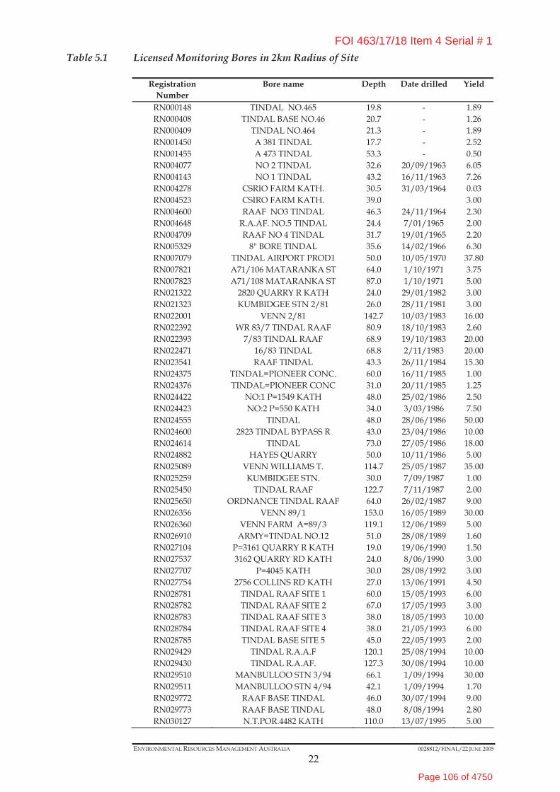
The Northern Territory Department of Infrastructure, Planning and Environment (DIPE) maintains a register of groundwater bores in Northern Territory. A search of NT DIPE records of monitoring bores within a 2km radius of the site revealed the following list of bores (yielding 0.1L or more).
FOI 463/17/18 Item 4 Serial # 1
Page 105 of 4750
ENVIRONMENTAL RESOURCES MANAGEMENT AUSTRALIA 0028812/FINAL/22 JUNE 2005
22
Table 5.1 Licensed Monitoring Bores in 2km Radius of Site
Registration Number
Bore name Depth Date drilled Yield
RN000148 TINDAL NO.465 19.8 - 1.89 RN000408 TINDAL BASE NO.46 20.7 - 1.26 RN000409 TINDAL NO.464 21.3 - 1.89 RN001450 A 381 TINDAL 17.7 - 2.52 RN001455 A 473 TINDAL 53.3 - 0.50 RN004077 NO 2 TINDAL 32.6 20/09/1963 6.05 RN004143 NO 1 TINDAL 43.2 16/11/1963 7.26 RN004278 CSRIO FARM KATH. 30.5 31/03/1964 0.03 RN004523 CSIRO FARM KATH. 39.0 3.00 RN004600 RAAF NO3 TINDAL 46.3 24/11/1964 2.30 RN004648 R.A.AF. NO.5 TINDAL 24.4 7/01/1965 2.00 RN004709 RAAF NO 4 TINDAL 31.7 19/01/1965 2.20 RN005329 8" BORE TINDAL 35.6 14/02/1966 6.30 RN007079 TINDAL AIRPORT PROD1 50.0 10/05/1970 37.80 RN007821 A71/106 MATARANKA ST 64.0 1/10/1971 3.75 RN007823 A71/108 MATARANKA ST 87.0 1/10/1971 5.00 RN021322 2820 QUARRY R KATH 24.0 29/01/1982 3.00 RN021323 KUMBIDGEE STN 2/81 26.0 28/11/1981 3.00 RN022001 VENN 2/81 142.7 10/03/1983 16.00 RN022392 WR 83/7 TINDAL RAAF 80.9 18/10/1983 2.60 RN022393 7/83 TINDAL RAAF 68.9 19/10/1983 20.00 RN022471 16/83 TINDAL 68.8 2/11/1983 20.00 RN023541 RAAF TINDAL 43.3 26/11/1984 15.30 RN024375 TINDAL=PIONEER CONC. 60.0 16/11/1985 1.00 RN024376 TINDAL=PIONEER CONC 31.0 20/11/1985 1.25 RN024422 NO:1 P=1549 KATH 48.0 25/02/1986 2.50 RN024423 NO:2 P=550 KATH 34.0 3/03/1986 7.50 RN024555 TINDAL 48.0 28/06/1986 50.00 RN024600 2823 TINDAL BYPASS R 43.0 23/04/1986 10.00 RN024614 TINDAL 73.0 27/05/1986 18.00 RN024882 HAYES QUARRY 50.0 10/11/1986 5.00 RN025089 VENN WILLIAMS T. 114.7 25/05/1987 35.00 RN025259 KUMBIDGEE STN. 30.0 7/09/1987 1.00 RN025450 TINDAL RAAF 122.7 7/11/1987 2.00 RN025650 ORDNANCE TINDAL RAAF 64.0 26/02/1987 9.00 RN026356 VENN 89/1 153.0 16/05/1989 30.00 RN026360 VENN FARM A=89/3 119.1 12/06/1989 5.00 RN026910 ARMY=TINDAL NO.12 51.0 28/08/1989 1.60 RN027104 P=3161 QUARRY R KATH 19.0 19/06/1990 1.50 RN027537 3162 QUARRY RD KATH 24.0 8/06/1990 3.00 RN027707 P=4045 KATH 30.0 28/08/1992 3.00 RN027754 2756 COLLINS RD KATH 27.0 13/06/1991 4.50 RN028781 TINDAL RAAF SITE 1 60.0 15/05/1993 6.00 RN028782 TINDAL RAAF SITE 2 67.0 17/05/1993 3.00 RN028783 TINDAL RAAF SITE 3 38.0 18/05/1993 10.00 RN028784 TINDAL RAAF SITE 4 38.0 21/05/1993 6.00 RN028785 TINDAL BASE SITE 5 45.0 22/05/1993 2.00 RN029429 TINDAL R.A.A.F 120.1 25/08/1994 10.00 RN029430 TINDAL R.A.AF. 127.3 30/08/1994 10.00 RN029510 MANBULLOO STN 3/94 66.1 1/09/1994 30.00 RN029511 MANBULLOO STN 4/94 42.1 1/09/1994 1.70 RN029772 RAAF BASE TINDAL 46.0 30/07/1994 9.00 RN029773 RAAF BASE TINDAL 48.0 8/08/1994 2.80 RN030127 N.T.POR.4482 KATH 110.0 13/07/1995 5.00
FOI 463/17/18 Item 4 Serial # 1
Page 106 of 4750
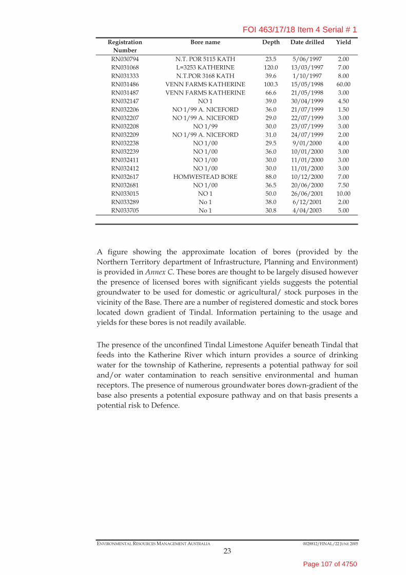
ENVIRONMENTAL RESOURCES MANAGEMENT AUSTRALIA 0028812/FINAL/22 JUNE 2005
23
Registration Number
Bore name Depth Date drilled Yield
RN030794 N.T. POR 5115 KATH 23.5 5/06/1997 2.00 RN031068 L=3253 KATHERINE 120.0 13/03/1997 7.00 RN031333 N.T.POR 3168 KATH 39.6 1/10/1997 8.00 RN031486 VENN FARMS KATHERINE 100.3 15/05/1998 60.00 RN031487 VENN FARMS KATHERINE 66.6 21/05/1998 3.00 RN032147 NO 1 39.0 30/04/1999 4.50 RN032206 NO 1/99 A. NICEFORD 36.0 21/07/1999 1.50 RN032207 NO 1/99 A. NICEFORD 29.0 22/07/1999 3.00 RN032208 NO 1/99 30.0 23/07/1999 3.00 RN032209 NO 1/99 A. NICEFORD 31.0 24/07/1999 2.00 RN032238 NO 1/00 29.5 9/01/2000 4.00 RN032239 NO 1/00 36.0 10/01/2000 3.00 RN032411 NO 1/00 30.0 11/01/2000 3.00 RN032412 NO 1/00 30.0 11/01/2000 3.00 RN032617 HOMWESTEAD BORE 88.0 10/12/2000 7.00 RN032681 NO 1/00 36.5 20/06/2000 7.50 RN033015 NO 1 50.0 26/06/2001 10.00 RN033289 No 1 38.0 6/12/2001 2.00 RN033705 No 1 30.8 4/04/2003 5.00
A figure showing the approximate location of bores (provided by the Northern Territory department of Infrastructure, Planning and Environment) is provided in Annex C. These bores are thought to be largely disused however the presence of licensed bores with significant yields suggests the potential groundwater to be used for domestic or agricultural/ stock purposes in the vicinity of the Base. There are a number of registered domestic and stock bores located down gradient of Tindal. Information pertaining to the usage and yields for these bores is not readily available.
The presence of the unconfined Tindal Limestone Aquifer beneath Tindal that feeds into the Katherine River which inturn provides a source of drinking water for the township of Katherine, represents a potential pathway for soil and/or water contamination to reach sensitive environmental and human receptors. The presence of numerous groundwater bores down-gradient of the base also presents a potential exposure pathway and on that basis presents a potential risk to Defence.
FOI 463/17/18 Item 4 Serial # 1
Page 107 of 4750

ENVIRONMENTAL RESOURCES MANAGEMENT AUSTRALIA 0028812/FINAL/22 JUNE 2005
24
6 SITE INSPECTION
6.1 SITE VISIT
A detailed site inspection was conducted by ERM personnel between the 19th and 20th April 2005. General site observations made during the site visits are provided below for the three CSR sites and the maintenance area. Additional observations are also provided below for areas where potentially contaminating activities were identified.
6.2 INTERVIEWS
During the site inspection a number of interviews were conducted with personnel from RAAF Base Tindal. Details of the personnel interviewed are summarised below.
Table 6.1 Personnel Interviewed During the Site Investigation
Name / Title Position Date Interviewed Ms Robyn Maurer NT Regional Environmental Officer
(General Site info) 19/04/2005
Sgt Mick Henderson Fire Training Area and Fire Station 19/04/2005
Mr David Reem Maintenance Area
19/04/2005
Staff Sargent Leigh Mills Fuel Farms
20/04/2005
Mr Brian Rigglesworth Burial Sites, Aldrin Use 20/04/2005
Due to the nature of the Defence postings at the Base, there are difficulties in locating personnel with more than 2-3 years knowledge of the site. Information provided during these interviews is summarised in the following sections.
6.3 SITE RECONNAISSANCE
To assist with ground truthing of the CSR issues (Table 6.2 below) ERM attended RAAF Base Tindal on 19 and 20 April 2005. For the purpose of the report CSR entries have been consolidated into similar issues and locations at RAAF Base Tindal. A summary of the findings of the field investigation are presented in Section 6.3.1 to Section 6.3.5.
FOI 463/17/18 Item 4 Serial # 1
Page 108 of 4750

ENVIRONMENTAL RESOURCES MANAGEMENT AUSTRALIA 0028812/FINAL/22 JUNE 2005
25
Table 6.2 Details of Sites from the CSR – RAAF Base Tindal
CSR Ref. No Area Comments NT0064 Fire Training
Area Soil around evaporation pits heavily stained with hydrocarbons and pits are not covered and not regularly maintained (weeds & silt) which could promote hydrocarbon contamination of surrounding area. Un-bunded mobile diesel tanker stored in the area noted leaking fuel. Although foam testing is meant to occur at the site, testing is also likely to occur behind fire station as no water supply is available near the fire training pits. Scrap metals and rubbish have been removed from site. Entire facility is now scheduled for upgrade in FY04/05 but redevelopment did not proceed due to lack of funding. No finances have been allocated to this project and the redevelopment of the site is unlikely to occur in the next 2 financial years.
NT0065 Fire Station Testing of fire lines and hoses (with foam) has been undertaken behind fire station with foam and wastewater being directed into a poorly constructed ‘evaporation pond’ (ie hole in the ground with no lining) thus soil and ground water contamination could result. Foam, fuel and oil was also found to be stored near a drain with potential contamination issues.
NT0045 Insecticide 2000 Phase 1 Initial enviro review (SKM) outlined Aldrin use on site until 1988. In particular a file note outlines a quantity of Aldrin was poured into holes dug on-site for trees prior to planting.
- Maintenance Area 322CSS
Identified as a potential area of concern and added prior to the planned site visit, by the Defence Regional Environmental Officer for RAAF Base Tindal.
Source: CSIG and RAAF Tindal REO
6.3.1 NT0064 - The Fire Training Area
The fire training area shown in Figure 3 in Annex A comprised an open cleared area approximately 150m2 with a centrally located bunded fire pit bounded by a paved area and a shallow drain. The fire pit drained (via an underground drain) into three evaporation ponds to the northwest, which were approximately 1.8m in depth. These ponds contained an outlet approximately two thirds of the way from the top of the pond that drained in an open surface drain running southeast to northwest. The ponds were observed to contain approximately 10cm of sludge. Some evidence of vegetation dieback was observed between the three ponds, however no other impacts were evident either down gradient of the ponds or across the site. Some slight hydrocarbon odours were noted in proximity to the burnt shipping containers and the leaking diesel tanker.
It is understood that the fire training area experiences surface flooding at different times of the year and has experienced extensive flooding previously.
Some surface soil staining with hydrocarbons and ash was observed along the southwestern side of the site where various fire-training exercises had taken place. This area also contained a number of burnt car bodies and five small to
FOI 463/17/18 Item 4 Serial # 1
Page 109 of 4750

ENVIRONMENTAL RESOURCES MANAGEMENT AUSTRALIA 0028812/FINAL/22 JUNE 2005
26
medium shipping containers holding various burnt/ partially burnt materials (including wood and furniture). An unbunded 2000L mobile diesel fuel tank was also observed on the eastern side of the fire training area, leaking diesel. Evidence of burnt materials outside of the fire training pit were observed across the site, however the most intensively used area appeared to be generally restricted to the western side of the site, and the pit which is understood to be used for liquid fuel fire exercises.
Following discussions with defence personnel it was identified that Aqueous Film Forming Foam or AFFF in the form of 3M 3% and 6% had not been used in training exercises since 2002/2003, however was used up to twice per week between 1988 and 2002 at the fire training area.
6.3.2 NT0065 - Fire Station
The fire station (identified in Figure 2, Annex A) comprised an office/ admin building attached to an open truck parking area dedicated to the RAAF fire trucks and vehicles. A large sealed bitumen area used for cleaning and testing the fire lines adjoined the fire station building to the south. A bunded Aqueous Film Forming Foam (AFFF) storage area containing 3M AFFF was located on the eastern side of the bitumen area, along with smaller unbunded containers of Ansulite AFFF.
A storm water drain running beneath the hardstand area was observed to drain into an open drain approximately 60m long that finishes in a heavily overgrown evaporation area on the western side of the fire station. The evaporation area was dry at the time of the site visit and appeared to have been unused for some time. A small amount of water was observed in the drain, with a slight sheen on the surface and what appeared to be detergent (most likely used in the washing down of vehicles and equipment).
No strong odours or vegetation dieback was observed at the site (apart from the centre of the evaporation area).
Discussions with Defence personnel revealed that AFFF waste water is released at fire station during cleaning and washing of the lines in the fire trucks which are washed in the order of 2-3 times per week.
The results of a URS investigation of the Fire Station, conducted in June 2002 identified elevated concentrations of Chromium, hydrocarbons and surfactants in evaporation pond water. The investigation however did not identify elevated concentrations of heavy metals or hydrocarbons in soil/ sediment samples analysed. Soil/sediment samples were not analysed for surfactants or components of AFFF. No mention was made in the report of the constituents in AFFF that are of environmental and human health concern. The results of the investigation however did suggest that significant widespread contamination had not resulted from the vehicle and equipment wash down practices conducted at the fire Station, however as the recommendations reflected, the practice of washing waste water containing
FOI 463/17/18 Item 4 Serial # 1
Page 110 of 4750
ENVIRONMENTAL RESOURCES MANAGEMENT AUSTRALIA 0028812/FINAL/22 JUNE 2005
27
residual AFFF into an unlined evaporation pond should be halted. The findings of this assessment included a provision for reducing wastewater (containing AFFF) and constructing an appropriately lined retention pond to protect the receiving environment.
6.3.3 NT0045 - Aldrin Use – Various
It is understood (based on a file note, attached in Annex B) that the use of Aldrin for termite and pest control at RAAF Base Tindal has ceased since at least 1987. The extent of the use of Aldrin prior to this date however is difficult to ascertain due to the small time frames (<3yrs) personnel are posted to the Base. It is expected that Aldrin was used to control termites when planting new seedlings when the base was first constructed in 1987 and potentially where any fibro or timber buildings were constructed in the 1960’s, however it is understood that many buildings were of metal construction. Based on the likely quantities used and timeframe it would be expected that some Aldrin contamination of the soil may have occurred in some localised areas, however it would not be expected to present a risk to human health based on the current use of the site. This is discussed further in Section 8.
6.3.4 NT0072 – 322CSS Maintenance Area
The RAAF Base Tindal Maintenance Area described here comprises three (3) primary maintenance areas, a fuel facility and a former battery store. The maintenance facilities included tanker maintenance area, Special Purpose Vehicles (SPV) and Ground Support Equipment (GSE) maintenance areas.
Tanker Maintenance Area
A tanker maintenance area was located opposite the former battery store. The facility consisted of a contained pit area designed for the conducting of repairs and refuelling activities with servicing pits located inside the workshop with oil disposal going to a 1,500L waste oil sump. Significant oil staining was observed adjacent to the soil sump indicating that the oil tank had over-flowed on a number of occasions. The sunken pit is understood to drain to an underground interceptor pit, which is believed to enter stormwater, however the frequency and adequacy of maintenance of this is not known, and therefore is thought to present a potential risk to surface water (SKM, 2005).
SPV Workshop Area
The SPV workshop were found to contain pits with an oil disposal facility joined to waste oil tanks and a drain linked to a double interceptor trap draining surface water run-off into stormwater. The interceptor trap comprised a water weir system which enables the separation of non-soluble free phase hydrocarbons on the surface of the water to be retained and release
FOI 463/17/18 Item 4 Serial # 1
Page 111 of 4750
ENVIRONMENTAL RESOURCES MANAGEMENT AUSTRALIA 0028812/FINAL/22 JUNE 2005
28
the remaining stormwater beneath. This system is thought to be ineffective if detergents and degreasers containing surfactants are used in the vicinity of the interceptor, as surfactants increase the solubility of the hydrocarbon component and/or create a hydrocarbon-water emulsion which may be more readily mobilised into the stormwater system.
The workshop area was covered in hardstand, with drainage directed to stormwater.
GSE Workshop Area
The Ground Support Equipment workshop was constructed similarly to other workshops with containment and an interceptor trap designed to separate hydrocarbons from water prior to release to stormwater.
As would be expected from a maintenance facility carrying out the volume of work expected of an operational RAAF Base, there were some areas of hydrocarbon staining and odour, however these were restricted to hardstand areas and contained on site. The site appeared to be constructed to generally contain fuel spills and manage waste hydrocarbons in such a way as to minimise the potential impacts on the environment.
Road Movements Refuelling Depot
The Road Movements Refuelling Depot is understood to contain a 41000L ULP underground storage tank and a 44000L diesel underground fuel storage (UST) tank. A further UST was understood to have been located to the east of the present ULP tank, but was removed in 1996 following reported leakage.
It is reported that the underground ULP tank was assessed as having been leaking for years when it was removed in 1996. There are no records of any remediation having been undertaken in this area.
A wash bay was observed adjacent to the fuel facility. It is understood that wastewater generated at the wash bay undergoes primary treatment via a ‘plated separator’ pit prior to release to storm water.
Discussions with defence personnel revealed that detergents and de-greasers have been used in the maintenance areas on occasions however recent management recommendations have included the introduction of a product that is designed to ensure no interference is caused with interceptor traps.
Some of the oil waste disposal tanks associated with workshops have alarms however some depend on personnel to check the tanks regularly to ensure they are pumped out in a timely fashion.
FOI 463/17/18 Item 4 Serial # 1
Page 112 of 4750

ENVIRONMENTAL RESOURCES MANAGEMENT AUSTRALIA 0028812/FINAL/22 JUNE 2005
29
6.3.5 Additional Potential Contaminated Sites
Following the site inspection and interviews with personnel, a number of additional potentially contaminated sites/ issues were identified and were assessed as requiring some degree of further investigation (or as minimum undergo a qualitative risk assessment). The following additional potential contaminated sites issues were identified by ERM during the site reconnaissance:
Fuel Farm No. 1. (NT0076)
Fuel Farm No. 2 (NT0077)
Former Landfill (NT0046) and burial sites (various locations).
During the site visit at Tindal, general site inspections were conducted for these issues. The associated observations are summarised below.
A previous identified fuel leak at the Frontline service station is understood to have been assessed as not presenting a risk to current users of the site. Based on the assessment conducted to date there is no indication that there is a requirement to conduct further investigation apart from ongoing groundwater monitoring (further discussed in Sampling and analysis plan Section).
Fuel farm No.1 (NT0076) and No. 2 (NT0077)
Fuel Farm No. 1 (FF1) and Fuel Farm No 2 (FF2) consisted of bunded trapezoid shaped above ground/ underground facilities comprised of 14 17,200L jet fuel tanks inside a concrete and a gravel covered structure. The structures also include a ventilation system and concrete lined bases with sloping weirs, draining to a mechanised fuel-water separator system and concrete lined evaporation ponds.
At the time of the site visit FF2 was not in operation due to problems with the original construction and design resulting in pressurisation faults and problems with hose/pipe fitting and electrical configuration. A fuel pipeline termed a ‘hydron line’ designed to service the Aircraft Movement Area (AMA), runs from fuel farm 2 to the air movements hardstand. The containment and spill minimisation design elements relating to the Hydron Line are not known, however the potential for significant unidentified leaks to occur from the Hydron line would appear to be a significant potential risk and source of contamination.
Site representatives reported that problems with Fuel Farm No. 2 and associated reticulation have occurred since construction in 1995. Whilst regular reconciliation of fuel volumes have never indicated any significant losses it is considered that some lesser spills / leaks are likely to have occurred.
FOI 463/17/18 Item 4 Serial # 1
Page 113 of 4750

ENVIRONMENTAL RESOURCES MANAGEMENT AUSTRALIA 0028812/FINAL/22 JUNE 2005
30
Former Landfill (NT0046) and Burial Sites (Various Locations)
Interviews with personnel and previous investigations have also identified other potentially contaminated sites comprised of landfill areas and burial sites. Although site inspections were not carried out at these locations the approximate positions are shown in Figure 2 (Annex A). It is understood that the exact locations of these may be difficult to determine from the ground.
Burial sites have been uncovered (By Mr Rigglesworth) during fire management activities at the Base. It is thought that the burial sites were largely associated with ordnance loading areas originally located to the south west of the base in the 1960’s and 1970’s.
Previous reports have identified both former landfill areas and current disposal areas. Some of these areas are understood to contain green waste while in other locations, the disposal of 205 L drums (contents unknown), building materials and scrap metal has been reported.
FOI 463/17/18 Item 4 Serial # 1
Page 114 of 4750

ENVIRONMENTAL RESOURCES MANAGEMENT AUSTRALIA 0028812/FINAL/22 JUNE 2005
31
7 DATA GAPS
A summary of data gaps identified is presented below
7.1 DATA GAPS IN THE SITE HISTORY REVIEW
The following gaps have been identified in the site history review:
There are significant gaps in the history of the site prior to the redevelopment of the base in 1988. The restricted nature of Defence land and operations contributes significantly to this.
The extent and nature of disposal of various materials, Sewage Treatment Plant (STP) waste water and landfill areas needs to be further investigated to ensure these areas do not present a potential occupational hazard as well as a potential environmental or human health hazard.
Information gained from reports by Dames and Moore, 1998 and 1999 has been reported here ‘second hand’ as these reports were not located/ provided in Defence documents.
Groundwater monitoring results conducted by Asset Services was not available at the time of the reporting, and although not entirely relevant to groundwater contamination issues, it is understood that some hydrocarbon analysis is conducted on a six-monthly basis. Access to this data would also enable the most effective groundwater sampling and analysis plan to be implemented and reduce unnecessary costs to Defence.
7.2 DATA GAPS IN THE SITE INSPECTION REVIEW
The following gaps have been identified in the site inspection:
The possible burial site locations were not inspected during the site visit due to the lack of information relating to the specific locations and the questionable value in locating these areas at the time of the inspections.
Additional potential areas of concern such as the sewage treatment plant and numerous small fuel storage facilities were not inspected in detail. Observation of the wastewater irrigation (‘horse paddock’) was carried out during the site visit.
FOI 463/17/18 Item 4 Serial # 1
Page 115 of 4750

ENVIRONMENTAL RESOURCES MANAGEMENT AUSTRALIA 0028812/FINAL/22 JUNE 2005
32
8 CONCEPTUAL SITE MODEL
8.1 INTRODUCTION
A CSM is the qualitative description of all plausible mechanisms by which receptors may be exposed to site contamination. For exposure to be considered possible, some mechanism (‘pathway’) must exist by which contamination from a given source can reach a given receptor. Such complete ‘source-pathway-receptor’ exposure mechanisms are commonly termed ‘pollutant linkages’. Exposure via these pollutant linkages is quantified and evaluated at later stages in the assessment. Pollutant sources, exposure mechanisms and receptors at the site are discussed below.
Potential exposure pathways are evaluated for completeness based on the existence of:
a source of chemical contamination;
a mechanism for release of contaminants from identified sources;
a contaminant retention or transport medium (eg. soil, air, groundwater etc.);
potential receptors of contamination; and
a mechanism for chemical intake by the receptors at the point of exposure (ie. ingestion, dermal contact or inhalation).
Whenever one or more of the above elements is missing, the exposure pathway is incomplete and there is therefore no risk to human health for example. An exposure pathway can be either “direct”, where the receptor comes into direct contact with the affected environmental media (eg. soil ingestion) and “indirect”, where exposure occurs at a different location or in a different medium than the source (eg. soil vapours volatilising to ambient air).
Potential sources, receptors and pollutant linkages (pathways) identified at the RAAF Tindal are described below.
8.2 SOURCE - POTENTIAL AREAS OF ENVIRONMENTAL CONCERN (AEC)
Based on the site history, site inspection and CSR potential areas of environmental concern (AECs) and associated chemicals of concern (CoC) have been identified. These are summarised in Table 8.1.below.
The historical use pesticides (particularly aldrin) in various areas of the base was highlighted as a potential issue and listed on the Defence Contaminated Sites Register. The use of aldrin however has not been included in this risk assessment due largely to the lack of detailed information available and (as discussed in Section 6.3.3) the current low sensitivity land use. Based on the
FOI 463/17/18 Item 4 Serial # 1
Page 116 of 4750

ENVIRONMENTAL RESOURCES MANAGEMENT AUSTRALIA 0028812/FINAL/22 JUNE 2005
33
current and expected future use of the site, the historical use of pesticides at the base is not considered likely to present a major potential risk to human health and a relatively low risk to identified sensitive environmental receptors.
Chronic exposure to pesticides through the food chain is considered the major exposure pathway to humans. The widespread consumption of local produce derived from the land at RAAF Tindal is not expected and therefore impacts to human health from residual soil contamination are considered likely to be extremely low. Surface water sampling has not indicated detectable levels of chlorinated pesticides therefore indications are that the impacts are likely to be localised. Potential impacts to sensitive environmental receptors such as endangered or rare bird species is more difficult to assess here.
Table 8.1 Summary of Sources - Potential Areas and Chemicals of Concern
CSR Number
AEC Potential / Known Source CoC*
NT0064 Fire Training Area
Potential for historical and current release of AFFF (3M – and associated organic compounds)
Heavy Metals, TPH, BTEX, Fuel additives
PAH, PFOS and flurochemicals
NT0065 Fire Station Potential for historical and current release of
AFF (3M – and associated organic compounds) Heavy Metals, TPH,
BTEX, PAH, PFOS and flurochemicals
NT0072 Maintenance
Area Potential for historic leaks and spills of hydrocarbons to have resulted in hydrocarbon sources in soil and groundwater. Including:
1500 L waste oil sum with surface oil staining at Tanker Maintenance Area;
Waste oil tanks at SPV Workshop Area;
General surface oil staining around the GSE Workshop Area; and
>40,000L ULP and Diesel USTs and former Diesel UST.
Heavy Metals, TPH, BTEX, Fuel additives
PAH,
NT0076NT0077
Fuel Farms No. 1 and No. 2
Potential for leaks / spills of hydrocarbon (Jet Fuel) from fuel tanks and associated reticulation (hydro line) to have resulted in soil and groundwater impact by hydrocarbons – particularly Fuel Farm No. 2
TPH, Fuel additives. BTEX.
NT0046 N/A
Dumping/ disposal of waste materials
Potential for leaching of a wide range of CoCs from the various legacy dumping/disposal grounds resulting in impact to soil and groundwater.
Heavy Metals OCP/OPP, Asbestos,
UXO, TPH, PAH, Ammonia Nitrates
FOI 463/17/18 Item 4 Serial # 1
Page 117 of 4750

ENVIRONMENTAL RESOURCES MANAGEMENT AUSTRALIA 0028812/FINAL/22 JUNE 2005
34
CSR Number
AEC Potential / Known Source CoC*
1. *CoC - Chemicals of Concern. 2. Heavy metals include Arsenic, Cadmium, Chromium, Copper, Lead, Zinc, Mercury, Nickel and Tin. 3. BTEX - Benzene, Toluene, Ethylbenzene and Xylene. 4. TPH - Total Petroleum Hydrocarbon. 5. PAH - Polynuclear Aromatic Hydrocarbon. 6. OC/OP – Pesticide suite. 7. UXO – Unexploded Ordnance. 8. PFOS - Perflurooctansulfonate
8.3 RECEPTORS
Based on the site review, the following receptors at RAAF Base Tindal are considered to be sensitive to impact from the identified sources.
Human Health – Site Workers.
Environment – Groundwater.
Environment – Tindal Creek Ecosystem.
Human Health - Recreational Water Use.
Human Health – Drinking Water.
It is noted that groundwater within the limestone aquifer provides a potable groundwater resource in the region. Additionally, groundwater monitoring is undertaken at selected wells around site to test water quality although the location of these wells and the actual use of groundwater at the site has not been established at this time. Accordingly, on the basis of the site setting and the groundwater use the groundwater vulnerability and sensitivity are considered to be high.
The pollutant linkages are considered in detail in Section 8.4. below.
8.4 EXPOSURE PATHWAYS
For exposure to be considered possible, some mechanism (‘pathway’) must exist by which contamination from a given source can reach a given receptor. Pollutant sources, exposure mechanisms and receptors at the site are summarised in the following CSM matrix (Table 8.2).
FOI 463/17/18 Item 4 Serial # 1
Page 118 of 4750
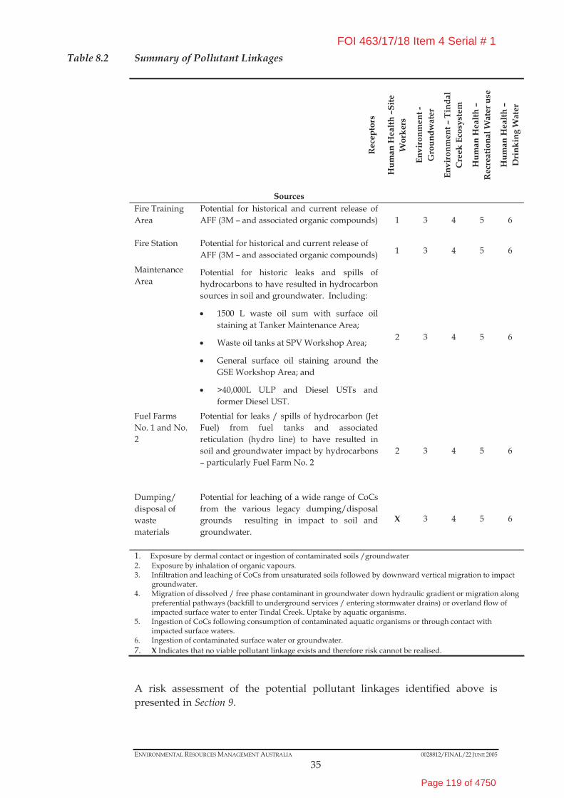
ENVIRONMENTAL RESOURCES MANAGEMENT AUSTRALIA 0028812/FINAL/22 JUNE 2005
35
Table 8.2 Summary of Pollutant Linkages
Rec
epto
rs
Hum
an H
ealth
–Si
te
Wor
kers
Envi
ronm
ent -
G
roun
dwat
er
Envi
ronm
ent –
Tin
dal
Cre
ek E
cosy
stem
Hum
an H
ealth
–
Rec
reat
iona
l Wat
er u
se
Hum
an H
ealth
–
Dri
nkin
g W
ater
Sources Fire Training Area
Potential for historical and current release of AFF (3M – and associated organic compounds) 1 3 4 5 6
Fire Station Potential for historical and current release of AFF (3M – and associated organic compounds) 1 3 4 5 6
Maintenance Area
Potential for historic leaks and spills of hydrocarbons to have resulted in hydrocarbon sources in soil and groundwater. Including:
1500 L waste oil sum with surface oil staining at Tanker Maintenance Area;
Waste oil tanks at SPV Workshop Area;
General surface oil staining around the GSE Workshop Area; and
>40,000L ULP and Diesel USTs and former Diesel UST.
2 3 4 5 6
Fuel Farms No. 1 and No. 2
Potential for leaks / spills of hydrocarbon (Jet Fuel) from fuel tanks and associated reticulation (hydro line) to have resulted in soil and groundwater impact by hydrocarbons – particularly Fuel Farm No. 2
2 3 4 5 6
Dumping/ disposal of waste materials
Potential for leaching of a wide range of CoCs from the various legacy dumping/disposal grounds resulting in impact to soil and groundwater.
X 3 4 5 6
1. Exposure by dermal contact or ingestion of contaminated soils /groundwater 2. Exposure by inhalation of organic vapours. 3. Infiltration and leaching of CoCs from unsaturated soils followed by downward vertical migration to impact
groundwater. 4. Migration of dissolved / free phase contaminant in groundwater down hydraulic gradient or migration along
preferential pathways (backfill to underground services / entering stormwater drains) or overland flow of impacted surface water to enter Tindal Creek. Uptake by aquatic organisms.
5. Ingestion of CoCs following consumption of contaminated aquatic organisms or through contact with impacted surface waters.
6. Ingestion of contaminated surface water or groundwater. 7. X Indicates that no viable pollutant linkage exists and therefore risk cannot be realised.
A risk assessment of the potential pollutant linkages identified above is presented in Section 9.
FOI 463/17/18 Item 4 Serial # 1
Page 119 of 4750
ENVIRONMENTAL RESOURCES MANAGEMENT AUSTRALIA 0028812/FINAL/22 JUNE 2005
36
9 RISK ASSESSMENT
Risk assessment involves the consideration of the sources of the risk, their consequences and the likelihood that those consequences may occur. The purpose of this process is to distinguish the low risks from the high risks, allowing priorities to be set to reduce the more significant risks to acceptable levels. This risk assessment methodology also takes into account the corresponding impacts on Defence capability, safety, cost, social concerns and media exposure.
9.1 METHODOLOGY
This risk assessment methodology is based on the ‘Defence Environmental Risk Management Framework’ (Defence 2003), and the associated working document (CSI NQ, October 2003) which has been developed to be integrated with the Defence Environmental Management System (EMS).
Potential impacts to human health and the environment have been considered. For the risk assessment, a set of common elements to the impacts and threats was derived, which were assessed in a three-stage process, involving consequence analysis, likelihood and calculation of risk level. These three stages are outlined in detail below.
The risks and consequences posed by contamination source(s) present at the site are considered here in the context of the potential beneficial uses of the groundwater/ receiving waters and potential impacts to human health and the environment.
9.1.1 Consequence Analysis
Under the Defence risk framework the consequences of each key element are broken down into six different categories:
capability and mission;
environment;
community and Sustainability;
safety;
compliance and reputation; and
finance.
The potential outcomes are considered in the context of each category. A five level qualitative description of the severity is used to calculate a score (0-5) for each consequence category. Definitions for consequences are shown in Table 9.1.
FOI 463/17/18 Item 4 Serial # 1
Page 120 of 4750

ENVIRONMENTAL RESOURCES MANAGEMENT AUSTRALIA 0028812/FINAL/22 JUNE 2005
37
9.1.2 Likelihood
Once the potential outcomes of the key elements were assessed, the probability that the outcomes would actually occur was determined. A five level qualitative description of the probability was used to calculate a likelihood score (0-5). Definitions for likelihood are shown in Table 4.2. In relation to soil or groundwater contamination the likelihood of the identified outcome occurring is directly related to the ‘potential beneficial use’ of the groundwater and the plausibility of identified exposure pathways and impacts to human health and sensitive environmental receptors.
9.1.3 Calculation of Risk Level
Two levels of risk, the primary risk score (PRS) and the secondary risk score (SRS), were calculated. Both combine the consequence rating and likelihood ratings to provide an overall assessment of the degree of risk of each key element.
Primary Risk Score (PRS)
The PRS is a conservative measure of risk based on the most severe consequences across all the relevant criteria. The PRS was calculated according to the equation:
PRS = Maximum Consequence Rating x Likelihood Rating
Secondary Risk Score (SRS)
The SRS is a less conservative measure of risk which incorporates all relevant criteria, not just the most severe ones. The SRS was calculated according to the following equation:
SRS = Average Consequence Rating x Likelihood Rating
Risk scores were then banded into levels that provide an easily interpreted evaluation of the risk involved with each key element. Within levels, risks can be prioritised using the risk scores. The risk levels, their threshold values and indicative management actions are shown in Table 9.3.
FOI 463/17/18 Item 4 Serial # 1
Page 121 of 4750

ENVIRONMENTAL RESOURCES MANAGEMENT AUSTRALIA 0028812/FINAL/22 JUNE 2005
38
Table 9.1 Threat Criteria and Consequence Scales
Rating Capability & Mission Environment Community/ Sustainability Safety (Staff & Public) Compliance & Reputation Financial
5 C
atas
trop
hic
All activities cease. No resumption for at least 12 months. Major unacceptable delays in delivery of capability occurring at critical times. Unable to conduct missions. Failure to achieve critical performance goals.
A long term environmental harm. Permanent irreparable damage is caused to the environment.
Significant, extensive, detrimental long-term impacts on the community or public health. Irreparable damage to highly valued structures or locations of cultural significance or sacred value. Permanent and significant loss of scarce environmental resources.
Multiple fatalities, large number of major injuries or occupational illness (acute or chronic). Public exposed to a severe, adverse long-term health impact or life-threatening hazard.
Sustained detrimental national or state media reports. Subject of parliamentary committee hearing. Sustained community outrage. Potential large-scale class action, or prosecution with significant fine or imprisonment.
Extreme financial loss (>$10m) to remedy.
4 M
ajor
All normal activities curtailed. No resumption of normal activities for between 6 and 12 months. Major delays of capability delivery but at non-critical times. Unable to conduct missions. Failure to achieve some performance targets.
Significant environmental damage with widespread impacts. Damage may be permanent.
Significant detrimental impacts on the community or public health. Major damage to highly valued structures or locations of cultural significance or sacred value. Significant loss of scarce environmental resources.
Single fatality or serious non-recoverable injury, several major injuries. Permanent disablement. Public exposed to a hazard that could cause injuries or moderate adverse health effects.
Numerous detrimental national or state media reports. Subject of a number of parliamentary questions or ministerials. Organised community concern. High profile legal challenge or prosecution with heavy fine.
Major financial loss ($0.5-10m) to remedy.
3 M
oder
ate
Most activities affected. No resumption of normal activities for up to 6 months. Significant delays resulting in some reduction in performance.
Moderate violation of regulation or guideline with moderate damage to the environment and significant clean-up cost.
Detrimental impacts on the community or public health. Damage to valued structures or locations of cultural significance or sacred value. Loss of scarce environmental resources.
A number of safety incidents requiring treatment by a physician. Exposure of public to a hazard that could cause minor injuries or minor adverse health effects. Illness requiring treatment.
Detrimental national or state media reports. Subject of parliamentary questions or ministerials. Community concerns and complaints. Some legal constraints imposed minimal fine.
Moderate financial loss ($0.05-0 5m) to remedy.
2 M
inor
Modification to planned activities can be expected. Minor delays. Minor performance degradation.
Minor violation of regulation or guideline with minimal damage to the environment and small clean up. Immediately contained on-site.
Minor impact on the community or public health. Minor damage to valued structures or locations of cultural significance or sacred value. Minor loss of environmental resources.
A number of safety incidents requiring treatment by a qualified first aid person. Exposure of public to a hazard that does not cause injury or affect health adversely.
Detrimental local media reports. Subject of local government action. Random substantiated complaints from the community. Minor technical legal challenge or breach.
Minor financial loss ($0.005-0 05m) to remedy.
1 In
sign
ific
ant
Some minor modification to planned activities may be necessary. Insignificant delays. Negligible performance impact.
Negligible release or damage that is contained on-site and is non-reportable. The damage is fully recoverable with no permanent impact on the environment.
Negligible social impact. Negligible damage to valued structures or locations of cultural significance or sacred value. Negligible loss of environmental resources.
Minor of safety incidents only. Negligible impact on staff or the public. No lost work time.
Possibility of detrimental local media reports. Trivial substantiated complaints from the community. Negligible legal impact or breach.
Insignificant financial loss (<$0.005m) to remedy.
0 Nil
No impact on schedules. No environmental impact. No social impact, damage to valued structures or locations of cultural significance or sacred value or loss of environmental resources.
No incidents. No impact. No cost impact.
FOI 463/17/18 Item 4 Serial # 1
Page 122 of 4750
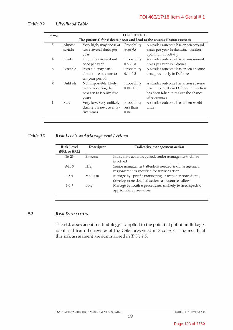
ENVIRONMENTAL RESOURCES MANAGEMENT AUSTRALIA 0028812/FINAL/22 JUNE 2005
39
Table 9.2 Likelihood Table
Rating LIKELIHOOD The potential for risks to occur and lead to the assessed consequences
5 Almost certain
Very high, may occur at least several times per year
Probability over 0.8
A similar outcome has arisen several times per year in the same location, operation or activity
4 Likely High, may arise about once per year
Probability 0.5 - 0.8
A similar outcome has arisen several times per year in Defence
3 Possible Possible, may arise about once in a one to ten year period
Probability 0.1 - 0.5
A similar outcome has arisen at some time previously in Defence
2 Unlikely Not impossible, likely to occur during the next ten to twenty-five years
Probability 0.04 - 0.1
A similar outcome has arisen at some time previously in Defence, but action has been taken to reduce the chance of recurrence
1 Rare Very low, very unlikely during the next twenty-five years
Probability less than 0.04
A similar outcome has arisen world-wide
Table 9.3 Risk Levels and Management Actions
Risk Level (PRL or SRL)
Descriptor Indicative management action
16-25 Extreme Immediate action required, senior management will be involved
9-15.9 High Senior management attention needed and management responsibilities specified for further action
4-8.9 Medium Manage by specific monitoring or response procedures, develop more detailed actions as resources allow
1-3.9 Low Manage by routine procedures, unlikely to need specific application of resources
9.2 RISK ESTIMATION
The risk assessment methodology is applied to the potential pollutant linkages identified from the review of the CSM presented in Section 8. The results of this risk assessment are summarised in Table 9.5.
FOI 463/17/18 Item 4 Serial # 1
Page 123 of 4750
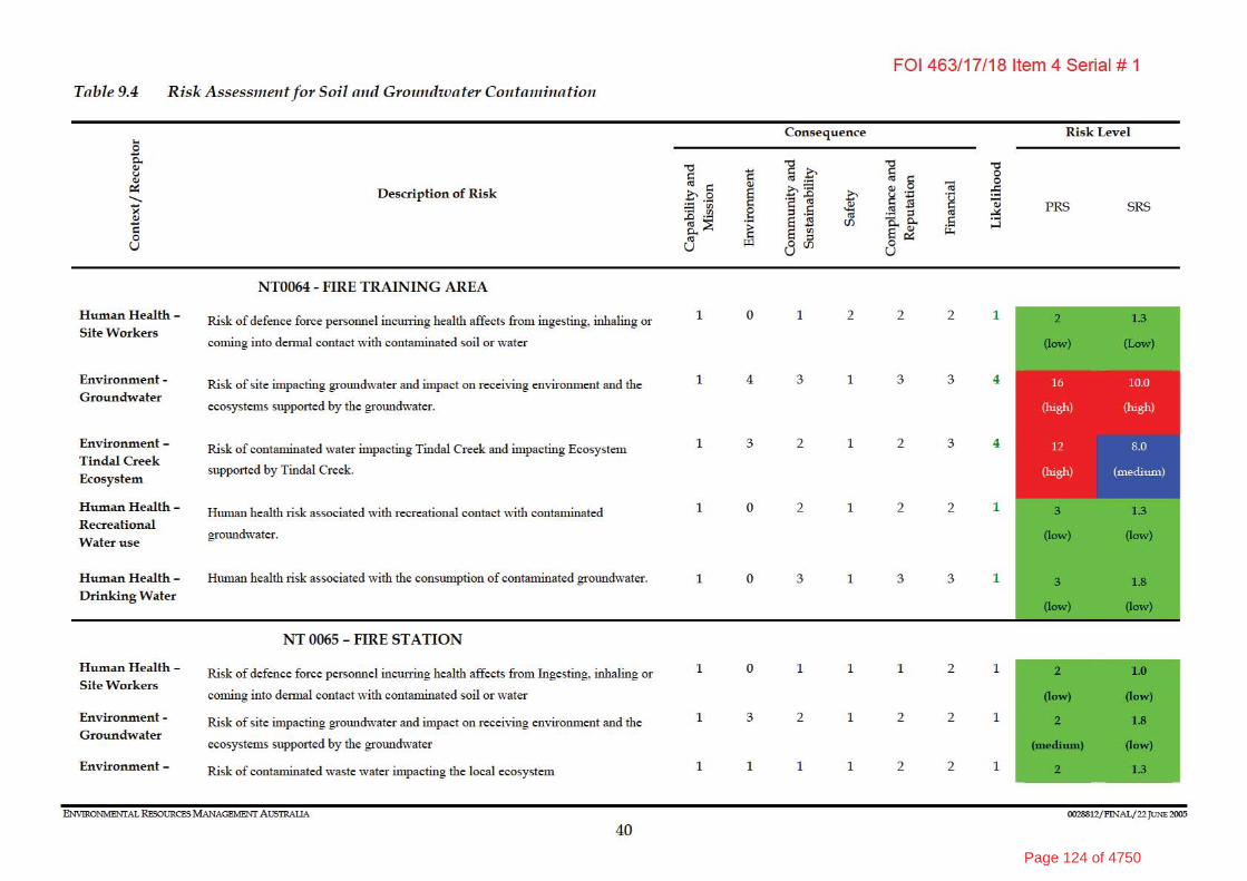
Page 124 of 4750

Page 125 of 4750
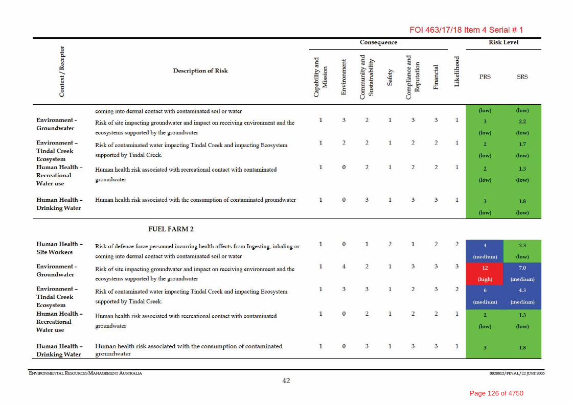
Page 126 of 4750

Page 127 of 4750

ENVIRONMENTAL RESOURCES MANAGEMENT AUSTRALIA 0028812/FINAL/22 JUNE 2005
45
9.3 DISCUSSION
9.3.1 Primary Assumptions
The assessment of risk from soil and groundwater contamination presented in Table 9.4 is generally based on the assumption of the presence of a source (or sources) of associated CoC in the environment. The assessment generally considers issues associated with legacy (historical) issues, which are assumed to be providing an ongoing impact to the environment. In most instances the presence of these sources has not been established by site sampling. The potential sources have been inferred from the site history review and site inspection.
9.3.2 Outcomes
The primary objective of the risk assessment has been to refine the qualitative risk score of each of the identified issues in order to prioritise the sites for Stage 2 Contamination Assessment where this is considered necessary. In this circumstance a Stage 2 Assessment is considered necessary where high-risk scores are obtained.
No extreme risks have been identified associated with any of the legacy issues.
High Primary Risk Scores (PRS) are associated with NT0064 (Fire Training Area), Maintenance Area (particularly the USTs), Fuel Farm 2 and reported Burial / Landfill sites. In general, the primary risk driver is impact to the environment (groundwater) and the associated potential clean-up costs. However, the PRS at the fire training area is also assessed as high with respect to Tindal Creek reflecting the existence of a direct drainage pathway discharging run-off from the training area to the creek.
The PRS and SRS for all other pollutant linkages has been assessed as low to medium.
Collection of soil and groundwater samples would allow further refinement of the risk levels at all the listed sites, however, it is proposed that, at this time, Stage 2 Sampling should be restricted to those pollutant linkages identified as high risk. Accordingly, Stage 2 Site Assessment is proposed at the following sites.
FOI 463/17/18 Item 4 Serial # 1
Page 128 of 4750
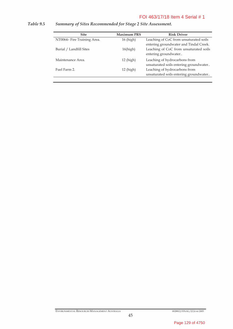
ENVIRONMENTAL RESOURCES MANAGEMENT AUSTRALIA 0028812/FINAL/22 JUNE 2005
45
Table 9.5 Summary of Sites Recommended for Stage 2 Site Assessment.
Site Maximum PRS Risk Driver NT0064– Fire Training Area. 16 (high) Leaching of CoC from unsaturated soils
entering groundwater and Tindal Creek. Burial / Landfill Sites 16(high) Leaching of CoC from unsaturated soils
entering groundwater..
Maintenance Area. 12 (high) Leaching of hydrocarbons from unsaturated soils entering groundwater..
Fuel Farm 2. 12 (high) Leaching of hydrocarbons from unsaturated soils entering groundwater..
FOI 463/17/18 Item 4 Serial # 1
Page 129 of 4750

ENVIRONMENTAL RESOURCES MANAGEMENT AUSTRALIA 0028812/FINAL/22 JUNE 2005
45
10 SAMPLING AND ANALYTICAL PLAN
The historical appraisal findings, the proposed use of the site and site conditions are factors to be considered when designing a sampling program for a given site.
The Sampling and Analysis Plan (SAP) below details the number and location of soil, sediment, and groundwater sampling points and the rationale behind their location. It also describes field sampling methods, the analytical program, the basis for assessment criteria selection, and the data quality objectives selected to assess the adequacy of the analysis procedure.
10.1 SOIL SAMPLING STRATEGY
Based on the continued use of the site as an operational Defence facility and the findings of the site history review, ERM consider that a combined targeted soil sampling, sediment and groundwater plan is appropriate for this site. The combined targeted soil sampling and sediment sampling and groundwater monitoring program has been proposed to assess the impacts of potentially contaminating activities and identified areas of environmental concern on sensitive receptors and provide an ongoing means of assessment. A review of the proposed sampling program following the first round of groundwater monitoring is recommended in order to further tailor the sampling plan to address any additional sources of contamination identified in groundwater analysis results.
10.1.1 Sampling Pattern
A targeted sampling (judgemental sampling) program is recommended for this site, to allow for assessment of specific locations identified where (based on the site history) there is considered a higher probability of contamination occurring that may present a risk to the environment or site users. Those areas identified as the Areas of Environmental Concern in the site history review include the following:
Fire Training Area
Maintenance Area
Fire Station
Burial/ Landfill Sites
Fuel Farm No. 1 and Fuel Farm No. 2
The fire training area and the maintenance area were assessed as having a ‘high’ risk of contamination impacting the environment and are therefore subject to targeted sampling program. Seven sampling locations are proposed for the fire training area and two targeted sampling locations for the
FOI 463/17/18 Item 4 Serial # 1
Page 130 of 4750
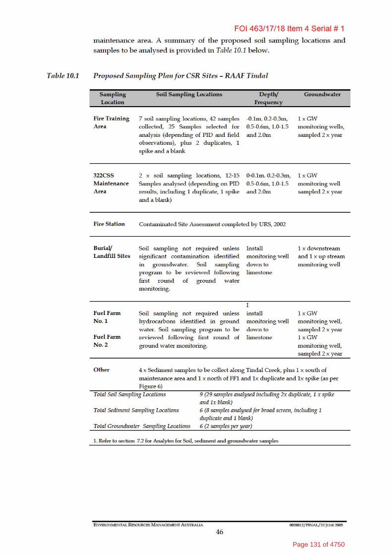
Page 131 of 4750
ENVIRONMENTAL RESOURCES MANAGEMENT AUSTRALIA 0028812/FINAL/22 JUNE 2005
45
Targeted sampling is proposed in the areas of suspected contamination. Environmental soil samples will be collected from each of the test pits/ bores, and groundwater well locations. For test pits, samples will be collected from the centre of the soil in the backhoe bucket. Hand auger samples will be collected directly from the auger. Each sample will be divided into two sub-samples. One of the sub-samples will be placed into a laboratory-supplied, acid-rinsed 250mL-glass jar and placed in an ice-filled cooler box. The other will be bagged for field headspace screening.
At this stage samples are proposed to be collected from depths of approximately 0.1 m, 0.3 m, 0.5 m and at 0.5-m intervals thereafter. Samples would also be collected at material type interfaces. Where fill locations have been identified, samples would be collected at vertical intervals of approximately 0.5 m.
A photoionisation detector (PID) will be used to screen the headspace gases of bagged soil samples in the field. The PID provides a semi-quantitative indication of the presence of ionisable volatile organic compounds in the soil.
10.1.2 Sediment Sampling and Assessment
Sediments often represent the ultimate repository for major bioaccumulative and harmful contaminants in the environment. Sediments constitute a significant component of aquatic ecosystems and as such assessment of the ecological risks posed by contaminated sediments is required.
Both current and historical activities conducted at RAAF Tindal suggest that contamination of sediments in stormwater drains, Tindal Creek and potentially Katherine River may have resulted.
It is appropriate that a Sediment Quality Assessment be undertaken in an environment where sediments may be a source of contaminants to the benthic food chain and where changes in water quality may adversely impact human health and the environment. An effective sediment quality assessment will be conducted in accordance with Handbook for Sediment Quality Assessment, 2005 and may include consideration of sediment chemistry, bioavailability testing, toxicity testing, bioaccumulation/ biomagnification assessment and assessment of the benthic community structure. In this case however it is considered sufficient to conduct sampling and initial screening of the results against the sediment quality guidelines (refer to Table 3.5.1 in Chapter 3 of the ANZECC/ ARMCANZ, 2000 Guidelines).
Sediment Sampling
A sediment sampling program is proposed in association with the preliminary groundwater monitoring program recommended for RAAF Tindal. The sediment sampling program is designed to provide a means of assessing if
FOI 463/17/18 Item 4 Serial # 1
Page 132 of 4750

ENVIRONMENTAL RESOURCES MANAGEMENT AUSTRALIA 0028812/FINAL/22 JUNE 2005
46
contamination present in the sediments on the base, pose a potential risk to human health and/ or sensitive ecological receptors.
Sediment sampling is proposed at four sites along Tindal Creek and two stormwater drain locations on the base (one south of maintenance area and one north of FF1) and potentially Katherine River if results identify significant contamination. Two background sampling locations representing background sediment quality should also be collected from Tindal Creek and or streams to the south of RAAF Base Tindal. Sampling should be conducted in accordance with the approved methods described in Chapter 4 of the ANZECC/ ARMCANZ Guidelines, (Field Sampling Program, Section 4.3.5).
10.1.3 Groundwater Sampling
Groundwater Sampling from New Wells
ERM proposes to install a total of six (6) monitoring wells; one up-gradient, two down gradient wells and three in proximity to sleeted areas of concern. The wells would be installed in bores drilled using a truck mounted drill rig. If located groundwater sampling should be conducted from existing wells if they are determined to be intact and the integrity can be confirmed.
A driller licensed by the Northern Territory Department of Infrastructure, Planning and Environment will be used. The bores are expected to be drilled to a depth of approximately 4 m, or 2 m below the intercepted groundwater. The bores would be installed in accordance with “Minium Construction Requirements for Water Bores in Australia” (ARMCANZ 1997) and specific ERM supplied construction details.
The groundwater wells would be constructed with approximately 3m of machine slotted 50mm diameter PVC screen at the base and will be extended to above the surface with 50mm PVC casing. The boreholes will be backfilled with graded sand to above the top of the screen and sealed with bentonite pellets to isolate surface run-off and perched water. The collar heights of the wells will be surveyed on site using a dumpy level. Following construction, the well would be developed by removing water until the silt content is significantly reduced.
10.2 LABORATORY ANALYTICAL PROGRAM
10.2.1 Soil Analysis
Primary samples would be sent to Labmark Pty Ltd for analysis for a range of potential contaminants. The preliminary analytical programme is as follows:
25 individual samples from the fire training area selected for analysis of a broad range of contaminants (including 17 metals, cyanide, fluoride, total
FOI 463/17/18 Item 4 Serial # 1
Page 133 of 4750

ENVIRONMENTAL RESOURCES MANAGEMENT AUSTRALIA 0028812/FINAL/22 JUNE 2005
47
petroleum hydrocarbons (TPH), benzene, toluene, ethylbenzene, xylene (BTEX), polycylic aromatic hydrocarbons (PAHs), organochlorine pesticides (OCP), organophosphate pesticides (OPP), phenols, volatile halogenated compounds, perfluorooctane sulfonate, surfactants and pH)
15 individual samples analysed for TPH and BTEX and heavy metals and selected fuel additives are proposed for the maintenance area
10.2.2 Sediment Analysis
Sediment samples (including two background samples) should be analysed for a broad range of contaminants, including, 17 metals, cyanide, fluoride, total petroleum hydrocarbons (TPH), benzene, toluene, ethylbenzene, xylene (BTEX), polycylic aromatic hydrocarbons (PAHs), organochlorine pesticides (OCP), organophosphate pesticides (OPP), phenols, volatile halogenated compounds, perfluorooctane sulfonate, surfactants and pH.
An additional sample from each location should also be retained for additional analyses of the sediment physiochemical properties, including pore/ grain size, organic matter content and nutrient levels). These factors may require testing where screening levels show exceedences.
10.2.3 Groundwater and Analysis QA/QC
Collection of groundwater samples would occur approximately 2-3 days after bore installation or when the groundwater reaches a steady natural state. This delay is required to allow equilibration of groundwater chemistry around the groundwater well.
One round of groundwater samples would be collected from the new wells and from any existing monitoring wells (that visually appear to be in a good condition) in accordance with ERM standard sampling protocols including:
Prior to purging, measurement of the groundwater levels each well;
Purging of the wells prior to sampling by removing at least three well volumes (or until the well is dry) and until field parameters (pH and EC) become stable;
Field measurement of pH and EC following purging but prior to sampling;
Use of a low-flow pump with dedicated tubing or disposable bailers for each well;
Samples to be analysed for heavy metals will be filtered in the field using a 0.45 m filter;
Samples will be collected into laboratory-supplied containers and placed in a cooler box filled with ice; and
FOI 463/17/18 Item 4 Serial # 1
Page 134 of 4750

ENVIRONMENTAL RESOURCES MANAGEMENT AUSTRALIA 0028812/FINAL/22 JUNE 2005
48
The samples would be dispatched to the analytical laboratory under chain of custody procedures.
Groundwater samples will be analysed for 8 heavy metals (As, Cu, Cr, Cd, Ni, Pb, Zn and Hg), OC/OP pesticides, TPH, sulfate, phosphate, nitrate, ammonia, total Kjeldahl nitrogen and faecal coliforms. Any other contaminants identified to be elevated during the soil assessment would also be assessed.
10.3 QUALITY ASSURANCE AND QUALITY CONTROL
A number of actions, procedures, checks and decisions are undertaken by ERM to ensure the accuracy and reliability of analytical results and to ensure the representativeness and integrity of samples taken. These actions and procedures form ERM’s Quality Assurance processes and are in accordance with those described in Schedule B (3) of the NEPM and the practices detailed in AS 4482.1-1997 . ERM’s quality control processes are used to monitor and measure the effectiveness of quality assurance procedures and include operational techniques used to meet the guidelines and quality requirements. ERM use only NATA accredited laboratories for contaminated site assessments. Table 10.2 below provides a summary of the Quality Assurance and Quality Control (QA/QC) Procedures to be used in the Sampling and Analytical Plan.
Table 10.2 Summary of QA/QC Procedures to be Used for SAP
QA/QC PROCEDURE
DESCRIPTION
Record Keeping Full records of all field activities including, sample collection and soil description will be maintained on standard field logging sheets.
Sample Labelling Unique sample numbers will be used for each sample to clearly specify the sample origin (source, date and sample type code), preservation techniques used and accepting custody [of samples].
Chain of Custody Chain of custody documentation will be used for all sample transfers. Custody forms include sample numbers, description, sample date, type of analysis required and are to be signed by the persons transferring and accepting custody of the samples.
Sample Storage Soil samples are to be transferred in approved sampling containers with appropriate preservation as required and placed in cool storage prior to transfer to the laboratory.
Decontamination All equipment (including drilling augers) used in the sampling process will be decontaminated using Extran (a phosphate free detergent). Decontamination, followed by rinsing with distilled water will be used
NEPM: National Environmental Protection (Assessment of Site Contamination) Measure, 1999
FOI 463/17/18 Item 4 Serial # 1
Page 135 of 4750

ENVIRONMENTAL RESOURCES MANAGEMENT AUSTRALIA 0028812/FINAL/22 JUNE 2005
49
QA/QC PROCEDURE
DESCRIPTION
prior to mobilisation and between sampling locations to reduce the risk of cross contamination (false positives)
Sample Duplicates,
Blanks, Spikes and field Splits
In addition to the analysis of primary samples, field duplicate samples and inter-laboratory duplicate samples will be collected, trip blanks and spikes will also be analysed to assess aspects of the field protocols and laboratory performance and to classify the validity of the laboratory data. A review of recovery efficiencies (from sample matrix) and the Relative Percentage Differences (RPD) also reviewed to assess if duplicate samples are within the ranges recommended in the Australian Standards (AS4482.1.)
Laboratory Internal QA/QC
Where appropriate, the laboratory uses internal standards to check the consistency of the analytical processes (eg. injection volumes, instrument sensitivity and retention times for chromatographic systems). Sample splits and method validation processes will also be used as part of their internal QA/QC procedures.
* Defined in the ISO 8402-1994 Quality Management and Quality Assurance
10.3.1 Field Quality Assurance/ Quality Control
Quality control duplicate samples would be collected at a rate of 1 in 10 primary samples. Half of the duplicate samples would be labelled blind and sent to the primary laboratory for analysis. The other duplicate samples would be sent to a secondary laboratory for check testing. Rinsate samples would be collected at a rate of one sample per day following decontamination.
10.4 ASSESSMENT CRITERIA
10.4.1 Soil
Soil sample analysis results will be compared to Soil Investigation Levels in Schedule B (1) of the NEPM and based on Schedule B (7A) and Health Investigation Levels for Commercial or Industrial Use sites.
FOI 463/17/18 Item 4 Serial # 1
Page 136 of 4750

ENVIRONMENTAL RESOURCES MANAGEMENT AUSTRALIA 0028812/FINAL/22 JUNE 2005
45
10.4.2 Groundwater
Groundwater sample analysis results will be compared to ANZECC/ ARMCANZ (2000) trigger levels for protection of aquatic ecosystems. Background water quality parameter from off-site groundwater bores can also be collected for comparative assessment, however initially the hydrogeological chemistry and geology should be taken into account when assessing the significance of any exceedences observed in groundwater samples.
10.4.3 Sediment
Sediment sample analysis results should be assessed in accordance with Chapter 8 in the ANZECC Water Quality Guidelines. The sediment assessment process generally involves a series of assessment steps designed to not only compare results against relevant screening levels but to also assess the context (exposure scenario and background data), the bioavailability of various contaminants and the relevant toxicity. All steps in the assessment process may not be required in this instance as the aim is primarily to identify the presence of contamination (and therefore potential risk to water quality and the environment) and aid in the prioritisation of management procedures adopted at the RAAF Base Tindal.
The ANZECC/ ARMCANZ, 2000a Interim Sediment Quality Guidelines should be referred to for specific screening levels. Where exceedences are noted above the screening levels an assessment of the contaminant bioavailability should be made, including consideration of the sediment physical and chemical properties.
FOI 463/17/18 Item 4 Serial # 1
Page 137 of 4750

11 REFERENCES
ANZECC/ ARMCANZ, 2000, Australian and New Zealand Guidelines for Fresh and Marine Water Quality, Australian and New Zealand Environment and Conservation Council (ANZECC) and Agriculture and Resource Management Council of Australia and New Zealand (ARMCANZ), Volume 1&2, October 2000
ANZECC/ ARMCANZ, 2000a Interim Sediment Quality Guidelines
HLA- Envirosciences Pty Ltd, RAAF Base Tindal, Water Quality Investigation 2002-2003
HLA- Envirosciences Pty Ltd, RAAF Base Tindal, Water Quality Investigation 2003-2004
National Environmental Protection (Assessment of Site Contamination) Measure, 1999, Schedule B (2). Sample Design and Reporting, National Environmental Protection Council (NEPC)
OECD, 2002, Organisation for Economic Co-operation and Development, Environment Directorate, Joint Meeting of the Chemicals Committee and the Working Party on Chemicals, Pesticides and Biotechnology ‘Hazard Assessment of Perfluorooctane Sulfonate (PFOS) and its Salts’. 21 November 2002
Sinclair Knight Merz, Environmental Management Plan for RAAF Base Tindal, 19th July 2001, Ref. DNR04674
SKM, Phase 1: Initial Environmental Review (IER) for RAAF Base Tindal, 17 August 2000
SKM, Phase 3 Environmental Management Plan for RAAF Base Tindal, Final, DR04674, 19 July, 2001
SKM, Phase 3 Environment and Heritage Strategy/Implementation Plan for RAAF Base Tindal, Draft 2 DR04674, 16 May, 2001
SKM, EMS Development Phase 1 Environmental Review Report RAAF Base Tindal, Draft, 28 January 2005
US EPA, Quality Assurance – QA/G-4, Guidance for the Data Quality Objectives Process
US EPA, 2005, Reproductive Toxicology Division, Health Risk Potentials of Perfluoroalkyl Acids in Humans and Wildlife, http:www.epa.gov/nheerl/rtd/researchprgrams/rtd_rpcaption10.html
URS, Contamination Investigation, Fire Testing Area, RAAF Base Tindal, URS, 14 June 2002
FOI 463/17/18 Item 4 Serial # 1
Page 138 of 4750

Annex A
Figures
FOI 463/17/18 Item 4 Serial # 1
Page 139 of 4750

Annex B
Historical Aerial Photographs and Records
FOI 463/17/18 Item 4 Serial # 1
Page 140 of 4750

Annex C
Groundwater Bore Records and Aquifer Details
FOI 463/17/18 Item 4 Serial # 1
Page 141 of 4750

Annex D
Summary Worksheet/Table
FOI 463/17/18 Item 4 Serial # 1
Page 142 of 4750