Issue 8: Green Infrastructure, Biodiversity and Landscape ...
13
The Welborne Plan Issue 8: Green Infrastructure, Biodiversity and Landscape (WEL29 – WEL35) Actions arising from hearing session November 2014 CD-41
Transcript of Issue 8: Green Infrastructure, Biodiversity and Landscape ...
The Welborne Plan
Issue 8: Green Infrastructure, Biodiversity and Landscape (WEL29 – WEL35)
Actions arising from hearing session November 2014
CD-41
1
Introduction
Chapter 8 of the Welborne Plan deals with green infrastructure, biodiversity and landscape. At the Welborne Plan Examination, a number of pieces of work were requested by the Inspector, to address points raised at the hearings sessions. These are set out in this note.
1. A query was raised regarding the allotment provision at Welborne.
2. The Inspector requested that the Council consider how the eastern edge of the Welborne site could incorporate a landscape treatment to mitigate impact on views from the east.
3. The Inspector requested the Council provide further detail on how Suitable Alternative Natural Greenspace can be provided as part of a strategy to avoid damage to sensitive sites.
4. The site promoters offered to provide the Examination with information from survey work undertaken by them to inform a Habitats Regulation Assessment, and an indicative layout for Fareham Common.
1 Allotment provision During the hearings session a query was raised regarding the provision of allotments
at Welborne. Upon subsequent checking this highlighted an error in the table of open space requirements set out in policy WEL29 of the Welborne Plan. The table show a minimum standard of 0.34 hectares of allotments per 1,000 population. This is an error – the standard, as set out in the 2010 Fareham Allotment Strategy (FBC05) is 0.34 ha per 1,000 households, not 0.34 ha per 1,000 population. All other figures in the table included in Policy WEL29 are correct.
Based on the standards set out in the Borough Council’s Allotment Strategy, and the
Borough Council’s peak projections for population and dwellings set out in Table 3.2 of the IDP Stage 2 Report (EV29), the correct equivalent minimum standard per 1,000 population is 0.13 ha. Therefore the Council proposes the following modification to Policy WEL29, with new text underlined and deleted text struck through:
Type of open
space of GI Minimum standard (per 1,000 population)
To include
Parks and amenity open space
1.5 hectares Equipped play areas for children and for youth, with 14 pieces of play equipment per 1,000 1-12 years olds
Allotments 0.34 0.13 hectares
Sports pitches 1.2 hectares At least one all-weather pitch;
At least 4 full-sized Tennis courts;
At least one bowling green (of approximately 170 square metres)
Semi natural green space
3 hectares Local nature reserves
Similarly, the supporting text of the Welborne Plan incorrectly references the
2
allotments standard. Therefore the Council proposes the following modification to the third and fourth sentences of paragraph 8.9 of the Welborne Plan, with new text underlined and deleted text struck through:
It will also include giving the residents of Welborne the opportunity to grow their own
food and will provide at least 2.1 2.0 hectares of allotments, with the further opportunity to provide community orchards. This amount is based on the standard of 27 allotment plots per 1,000 population households.
The Council also proposes that footnote 130 at the bottom of page 105 of the
submission Welborne Plan is amended accordingly, with new text underlined and deleted text struck through:
The allotments standard being taken forward within Policy WEL29 derives from the
Fareham Allotment Strategy (FBC, 2010) and is based on 27 plots (of 125 square metres each) per 1,000 population households, which equates to 0.34 0.13 hectares per 1,000 population.
2 Eastern edge of Welborne site The Welborne Plan acknowledges the sensitive landscape to the east of the
Welborne site. This has informed the selection of the boundary of the Welborne site and the Sustainability Appraisal Framework, and in particular the SA Objective 3 (“To conserve and enhance the character of the landscape”) (SA05, Appendix E).
A description of that part of the site is set out in para. 4.11 of the Welborne Plan.
Paragraph 8.43 goes on to describe how “the land to the east of the A32 is clearly visible from Portsdown Hill, and will therefore require a sensitive approach to landscaping along this important edge”.
At the hearings sessions Council officers agreed to consider how this could be better
reflected in the Welborne Plan. While there is a desire to not be too prescriptive, upon reflection is would seem appropriate for policy WEL33 on Structural Landscaping to recognise this important consideration.
Therefore the Council proposes a modification to Policy WEL35 to recognise the
importance of structural landscaping with regards to the impact on views from the east, with new text underlined and deleted text struck through:
WEL33 - Structural Landscaping
Initial planning applications for the development of Welborne will be permitted where they are accompanied by a structural landscaping scheme which identifies how the existing landscape features on and around the site can be strengthened and used to create a unique 21st century model for a new garden community. Structural landscaping schemes will show how they respond positively to areas of high landscape quality to the north and east of the site and take into account any material impact on long distance views of the site from Portsdown Hill.
3
All structural landscaping schemes submitted to the Council for approval should include a detailed phasing and management plan, with the emphasis on bringing forward the structural planting elements in the early phases of the development.
3 How Suitable Alternative Natural Greenspace can be delivered Paragraphs 8.16 to 8.28 of the Welborne Plan set out the rationale for the
contribution Suitable Alternative Natural Greenspace (SANGs) can make to a strategy to help mitigate or avoid potentially adverse impacts on nearby environmentally sensitive sites. Paragraph 8.24 of the Welborne Plan sets out a description of key criteria for what constitutes SANGs.
In order to address this issue the Solent Disturbance Mitigation Partnership has
developed a strategy wherein new development within 5.6 kilometres of the coast will pay a financial contribution towards providing a range of measures aimed at mitigating potential impacts on the Special Protection Area. However it is recognised that for large scale developments such as Welborne a bespoke mitigation strategy would be more appropriate. This is likely to be a combination of on-site measures which will include large areas of Suitable Alternative Natural Greenspace (SANGS), and a prop-rata financial contribution. It is further recognised that such a strategy can only be developed and agreed with the Council and Natural England with the benefit of a detailed Habitats Regulations Assessment, required to accompany the outline planning application.
The site promoters have been working on a SANGs strategy to inform their
forthcoming planning application for Welborne. This is based on a visitor survey from the adjoining area to assess the likely effectiveness of the strategy being prepared by the site promoters (see appendix B). Part of that Strategy has been looking at how areas can fulfil a SANGs role. As an example, Appendix A of this document contains an illustrative sketch prepared on behalf of the site promoters demonstrating how Fareham Common could be laid out as SANG to provide a range of informal recreational facilities in a natural setting.
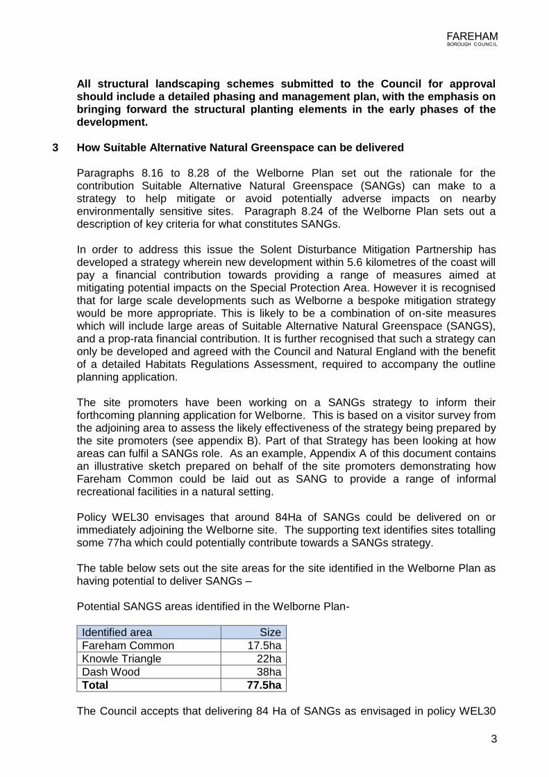
Policy WEL30 envisages that around 84Ha of SANGs could be delivered on or
immediately adjoining the Welborne site. The supporting text identifies sites totalling some 77ha which could potentially contribute towards a SANGs strategy.
The table below sets out the site areas for the site identified in the Welborne Plan as
having potential to deliver SANGs – Potential SANGS areas identified in the Welborne Plan-
Identified area Size
Fareham Common 17.5ha
Knowle Triangle 22ha
Dash Wood 38ha
Total 77.5ha
The Council accepts that delivering 84 Ha of SANGs as envisaged in policy WEL30
4
might require further land to be delivered. This could be a mixture of land on or immediately adjoining the Welborne site, including land at Pook Lane, and along the eastern edge of Welborne.
As part of a package of mitigation measures there would also be a series of
proposals aimed at improving dog walking facilities both on and off the site which will reduce the need for dog walkers to visit the coast of allow their dogs the freedom to exercise off of the lead. This could include the creation of circular walks utilising the existing under used foot path network adjoining the site, (adjacent footpaths are shown on the constraints map), which could be improved to help facilitate all year round use.
For the SANGS to be effective it will require a critical mass of greenspace to ensure a
natural experience. Both Dash Wood and Fareham Common which are currently available can provide that experience. However on their own they are unlikely to be able to provide enough SANGS to meet the needs of the new community, and additional areas of natural greenspace are likely to be required. The locations and final quantum of which will need to be determined through the HRA process, but as mentioned above there are a number of potential opportunities both on-site or immediately adjoining Welborne which will need to be explored by the site promoters.
In any event, the avoidance and mitigation strategy will comprise a series of
measures of which the provision of SANGS is only a part albeit a significant part. The balance between on-site measures and a financial contribution can only be determined through the HRA process, and if it does not prove possible to meet in full the target figure of 70% of the SANGS standard then a higher financial contribution would be required. But whatever the composition of the eventual package it must clearly demonstrate its effectiveness, and the wording or intention of the policy cannot change that fundamental requirement.
Therefore, any strategy for avoiding and mitigating the impact on the Internationally
protected site will need to demonstrate to the Council and Natural England how those impacts will be avoided or fully mitigated if the development is to gain approval. It should be noted that the site promoters have engaged in extensive pre-application discussion with the Council and Natural England on the most effective approach to ensure that all risks to the Solent SPA are either avoided or effectively mitigated, and Natural England has formally confirmed that the approach set out in policy WEL 30, is the most appropriate strategy for Welborne.
4 Evidence of the positive role Suitable Alternative Natural Greenspace can play
in avoiding damage to sensitive sites At the hearing session the site promoters offered to submit to the Examination details
of a visitor survey undertaken as part of a report produced to inform a Habitats Regulations Assessment for the Welborne development. The survey results follow as appendix B to this document. While the Council has not yet received a planning application for the development of Welborne, the survey work indicates the positive role that SANGs can play in helping to mitigate or avoid potentially adverse impacts on nearby environmentally sensitive sites and so is consistent with the advice that the Council has received from Natural England. The findings confirm that attractive well laid out areas of SANGS such as Fareham Common will be used by the local
5
community, and the conclusion can be drawn that it will also be an attractive asset for the new residents of Welborne.
Taking Fareham Common as an example; as can be clearly seen from the illustration
in Appendix A, the area is large enough to create a range of walks, which would be attractive to dog walkers who could allow their pets to exercise off of the lead. This area would link well with North Fareham and provide them with access to a significant area of natural greenspace It would also be possible to create a series of habitats which can greatly enhance biodiversity over the current agricultural use of the land. And by judicious planting the motorway can be effectively screened, and soften the views to Welborne from north Fareham.
The potential use of Dash Wood for SANGS has been the subject of discussions,
between the landowners’ consultants, Natural England, and the Council’s ecological consultant. The woodland is currently poorly managed and extensive areas are currently used for ‘war-games’ and paint-balling. The emerging proposals would see the removal of the current uses, and their accompanying structures within the woodland, and the layout of a series of new footpaths which avoid the most sensitive areas for nature conservation. Overall, all parties are convinced that with effective management, not only can the existing ecological interests be protected, but they can be actually enhanced, whilst fulfilling the woodland’s role as an area of attractive natural greenspace.

6
APPENDIX A
7
APPENDIX B This appendix contains extracts from a report produced by the site promoters to inform a Habitats Regulations Assessment for the Welborne Development. It sets out the resident survey results conducted to determine how effective SANGS may be as part of a strategy in avoiding or mitigating disturbance to sensitive sites in the Solent.
Extensive visitor survey (and some resident/household survey) was undertaken for the Solent Mitigation and Disturbance Project. However, by design this survey covered the entire Solent coastline which is sufficient to formulate conclusions as a Solent-wide level but does not provide high resolution data regarding how residents of particular parts of the Solent frontage utilize the coast. In order to inform a more detailed consideration of the likely appeal of the designated Solent coast to the population of Welborne, and also of the appeal of the proposed SANG, a survey was commissioned for this HRA. The questionnaire used in the survey and a summary of the overall responses to each question is included in Appendix 4. The survey was intended to gauge the likely recreational habitats of people living at Welborne. Clearly, since Welborne is not yet constructed it is not possible to do this directly. However, it is considered that the opinions of people currently living in the vicinity of the Welborne site would provide an appropriate proxy. Since this was a resident survey, rather than a coastal visitor survey, the survey was not undertaken at the coast but on the streets of North Fareham, Knowle and Funtley. The residents of the following postcode areas were specifically targeted: • PO15 6xx • PO16 7xx; and • PO17 5xx These postcode areas cover a zone south of the M27 from Henry Court Drive in the west, to Furzehall Avenue in the east (i.e. to the east of the A32) and south to the Stow Estate and Recreation Ground. They also cover the settlements of Funtley and Knowle. These three postcode areas have a total population of 20,737 people, the majority of whom live in the North Fareham area. The professional survey company/statisticians who undertook the survey confirmed that for a population of this size 400 interviews would provide a statistically representative sample. RESIDENT SURVEY SUMMARY RESULTS The following is a simply accessible overall summary of the questions included within the resident survey and the responses received. Do note that this is intended as a summary of all responses received. For the purposes of the analysis presented in this HRA report the response data was analysed further by various subsets (for example, removing people who only visited the coast during the summer, and then analyzing subsets of people who lived in different areas or said they would visit the coasts with different frequencies). In undertaking this survey respondents were shown plans of the Welborne site and its proposed SANG, outline plans as to how (for example) Fareham Common would look as a SANG and a map of the internationally designated Solent coast.
8
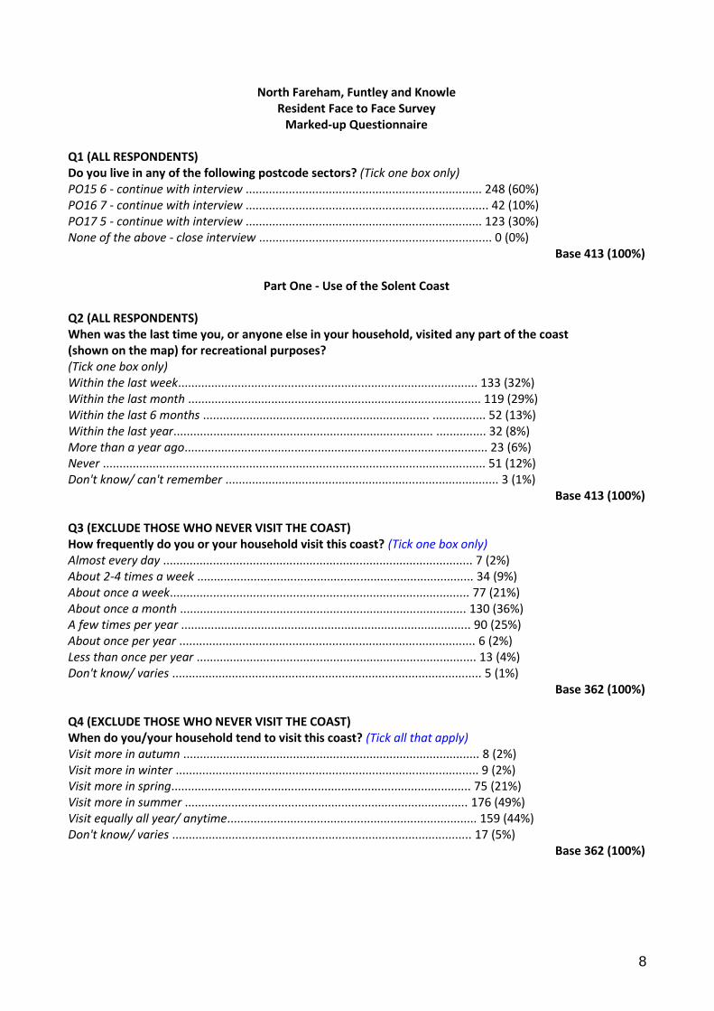
North Fareham, Funtley and Knowle Resident Face to Face Survey
Marked-up Questionnaire Q1 (ALL RESPONDENTS) Do you live in any of the following postcode sectors? (Tick one box only) PO15 6 - continue with interview ....................................................................... 248 (60%) PO16 7 - continue with interview ......................................................................... 42 (10%) PO17 5 - continue with interview ....................................................................... 123 (30%) None of the above - close interview ...................................................................... 0 (0%)
Base 413 (100%)
Part One - Use of the Solent Coast Q2 (ALL RESPONDENTS) When was the last time you, or anyone else in your household, visited any part of the coast (shown on the map) for recreational purposes? (Tick one box only) Within the last week.......................................................................................... 133 (32%) Within the last month ........................................................................................ 119 (29%) Within the last 6 months .................................................................... ................ 52 (13%) Within the last year.............................................................................. ............... 32 (8%) More than a year ago........................................................................................... 23 (6%) Never ................................................................................................................... 51 (12%) Don't know/ can't remember .................................................................................. 3 (1%)
Base 413 (100%) Q3 (EXCLUDE THOSE WHO NEVER VISIT THE COAST) How frequently do you or your household visit this coast? (Tick one box only) Almost every day ............................................................................................. 7 (2%) About 2-4 times a week ................................................................................... 34 (9%) About once a week.......................................................................................... 77 (21%) About once a month ...................................................................................... 130 (36%) A few times per year ....................................................................................... 90 (25%) About once per year ......................................................................................... 6 (2%) Less than once per year .................................................................................... 13 (4%) Don't know/ varies ............................................................................................. 5 (1%)
Base 362 (100%) Q4 (EXCLUDE THOSE WHO NEVER VISIT THE COAST) When do you/your household tend to visit this coast? (Tick all that apply) Visit more in autumn ......................................................................................... 8 (2%) Visit more in winter ........................................................................................... 9 (2%) Visit more in spring.......................................................................................... 75 (21%) Visit more in summer ..................................................................................... 176 (49%) Visit equally all year/ anytime........................................................................... 159 (44%) Don't know/ varies .......................................................................................... 17 (5%)
Base 362 (100%)
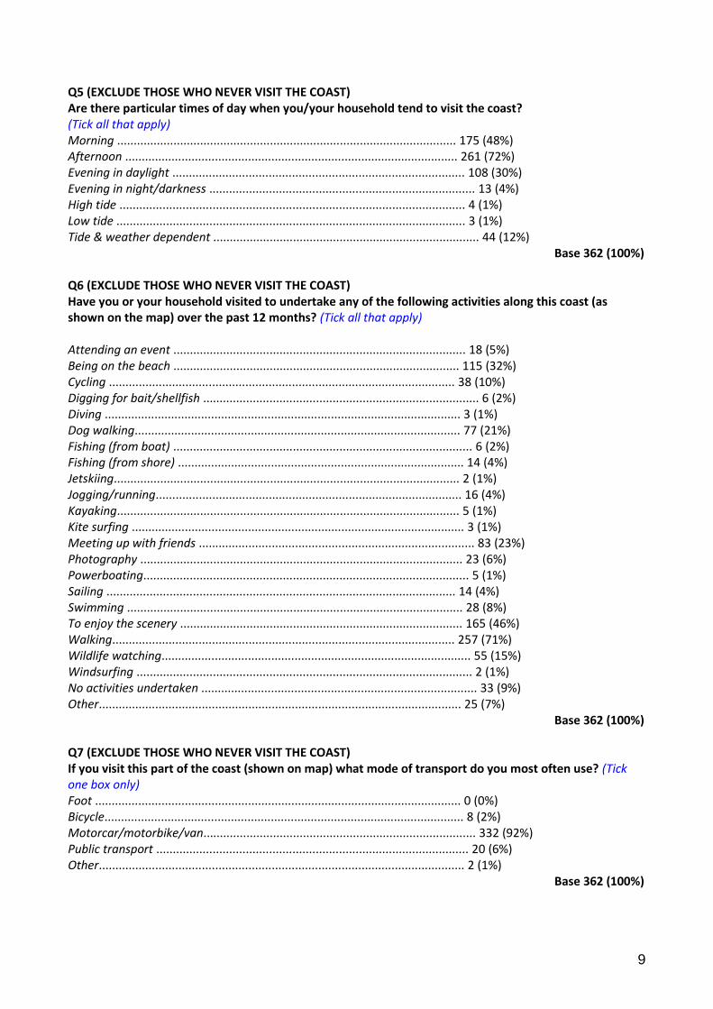
9
Q5 (EXCLUDE THOSE WHO NEVER VISIT THE COAST) Are there particular times of day when you/your household tend to visit the coast? (Tick all that apply) Morning ...................................................................................................... 175 (48%) Afternoon .................................................................................................... 261 (72%) Evening in daylight ........................................................................................ 108 (30%) Evening in night/darkness ................................................................................ 13 (4%) High tide ........................................................................................................ 4 (1%) Low tide ......................................................................................................... 3 (1%) Tide & weather dependent ................................................................................ 44 (12%)
Base 362 (100%) Q6 (EXCLUDE THOSE WHO NEVER VISIT THE COAST) Have you or your household visited to undertake any of the following activities along this coast (as shown on the map) over the past 12 months? (Tick all that apply) Attending an event ........................................................................................ 18 (5%) Being on the beach ...................................................................................... 115 (32%) Cycling ........................................................................................................ 38 (10%) Digging for bait/shellfish ................................................................................... 6 (2%) Diving ........................................................................................................... 3 (1%) Dog walking.................................................................................................. 77 (21%) Fishing (from boat) .......................................................................................... 6 (2%) Fishing (from shore) ...................................................................................... 14 (4%) Jetskiing........................................................................................................ 2 (1%) Jogging/running............................................................................................ 16 (4%) Kayaking....................................................................................................... 5 (1%) Kite surfing .................................................................................................... 3 (1%) Meeting up with friends ................................................................................... 83 (23%) Photography ................................................................................................. 23 (6%) Powerboating.................................................................................................. 5 (1%) Sailing ......................................................................................................... 14 (4%) Swimming ..................................................................................................... 28 (8%) To enjoy the scenery ..................................................................................... 165 (46%) Walking....................................................................................................... 257 (71%) Wildlife watching............................................................................................. 55 (15%) Windsurfing ..................................................................................................... 2 (1%) No activities undertaken ................................................................................... 33 (9%) Other............................................................................................................. 25 (7%)
Base 362 (100%) Q7 (EXCLUDE THOSE WHO NEVER VISIT THE COAST) If you visit this part of the coast (shown on map) what mode of transport do you most often use? (Tick one box only) Foot .............................................................................................................. 0 (0%) Bicycle............................................................................................................ 8 (2%) Motorcar/motorbike/van.................................................................................. 332 (92%) Public transport .............................................................................................. 20 (6%) Other.............................................................................................................. 2 (1%)
Base 362 (100%)
10
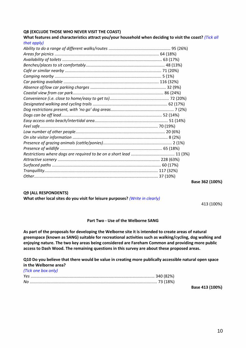
Q8 (EXCLUDE THOSE WHO NEVER VISIT THE COAST) What features and characteristics attract you/your household when deciding to visit the coast? (Tick all that apply) Ability to do a range of different walks/routes ...................................................... 95 (26%) Areas for picnics ........................................................................................... 64 (18%) Availability of toilets ....................................................................................... 63 (17%) Benches/places to sit comfortably..................................................................... 48 (13%) Café or similar nearby .................................................................................... 71 (20%) Camping nearby ............................................................................................. 5 (1%) Car parking available ................................................................................... 116 (32%) Absence of/low car parking charges .................................................................. 32 (9%) Coastal view from car park............................................................................... 86 (24%) Convenience (i.e. close to home/easy to get to).................................................... 72 (20%) Designated walking and cycling trails ................................................................. 62 (17%) Dog restrictions present, with ‘no go’ dog areas....................................................... 7 (2%) Dogs can be off lead........................................................................................ 52 (14%) Easy access onto beach/intertidal area................................................................ 51 (14%) Feel safe....................................................................................................... 70 (19%) Low number of other people.............................................................................. 20 (6%) On site visitor information ................................................................................... 8 (2%) Presence of grazing animals (cattle/ponies)............................................................ 2 (1%) Presence of wildlife ......................................................................................... 65 (18%) Restrictions where dogs are required to be on a short lead ...................................... 11 (3%) Attractive scenery ......................................................................................... 228 (63%) Surfaced paths ............................................................................................... 60 (17%) Tranquillity................................................................................................... 117 (32%) Other............................................................................................................ 37 (10%)
Base 362 (100%) Q9 (ALL RESPONDENTS) What other local sites do you visit for leisure purposes? (Write in clearly)
413 (100%)
Part Two - Use of the Welborne SANG As part of the proposals for developing the Welborne site it is intended to create areas of natural greenspace (known as SANG) suitable for recreational activities such as walking/cycling, dog walking and enjoying nature. The two key areas being considered are Fareham Common and providing more public access to Dash Wood. The remaining questions in this survey are about these proposed areas. Q10 Do you believe that there would be value in creating more publically accessible natural open space in the Welborne area? (Tick one box only) Yes ............................................................................................................ 340 (82%) No ............................................................................................................... 73 (18%)
Base 413 (100%)
11
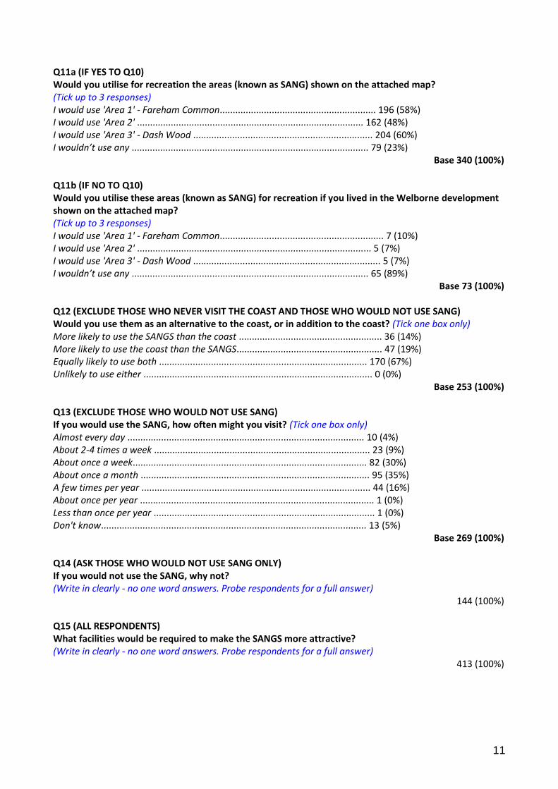
Q11a (IF YES TO Q10) Would you utilise for recreation the areas (known as SANG) shown on the attached map? (Tick up to 3 responses) I would use 'Area 1' - Fareham Common............................................................ 196 (58%) I would use 'Area 2' ....................................................................................... 162 (48%) I would use 'Area 3' - Dash Wood ..................................................................... 204 (60%) I wouldn’t use any ........................................................................................... 79 (23%)
Base 340 (100%) Q11b (IF NO TO Q10) Would you utilise these areas (known as SANG) for recreation if you lived in the Welborne development shown on the attached map? (Tick up to 3 responses) I would use 'Area 1' - Fareham Common............................................................... 7 (10%) I would use 'Area 2' .......................................................................................... 5 (7%) I would use 'Area 3' - Dash Wood ........................................................................ 5 (7%) I wouldn’t use any ........................................................................................... 65 (89%)
Base 73 (100%) Q12 (EXCLUDE THOSE WHO NEVER VISIT THE COAST AND THOSE WHO WOULD NOT USE SANG) Would you use them as an alternative to the coast, or in addition to the coast? (Tick one box only) More likely to use the SANGS than the coast ....................................................... 36 (14%) More likely to use the coast than the SANGS........................................................ 47 (19%) Equally likely to use both ................................................................................ 170 (67%) Unlikely to use either ........................................................................................ 0 (0%)
Base 253 (100%) Q13 (EXCLUDE THOSE WHO WOULD NOT USE SANG) If you would use the SANG, how often might you visit? (Tick one box only) Almost every day ........................................................................................... 10 (4%) About 2-4 times a week ................................................................................... 23 (9%) About once a week.......................................................................................... 82 (30%) About once a month ........................................................................................ 95 (35%) A few times per year ........................................................................................ 44 (16%) About once per year .......................................................................................... 1 (0%) Less than once per year ..................................................................................... 1 (0%) Don't know...................................................................................................... 13 (5%)
Base 269 (100%) Q14 (ASK THOSE WHO WOULD NOT USE SANG ONLY) If you would not use the SANG, why not? (Write in clearly - no one word answers. Probe respondents for a full answer)
144 (100%) Q15 (ALL RESPONDENTS) What facilities would be required to make the SANGS more attractive? (Write in clearly - no one word answers. Probe respondents for a full answer)
413 (100%)
12
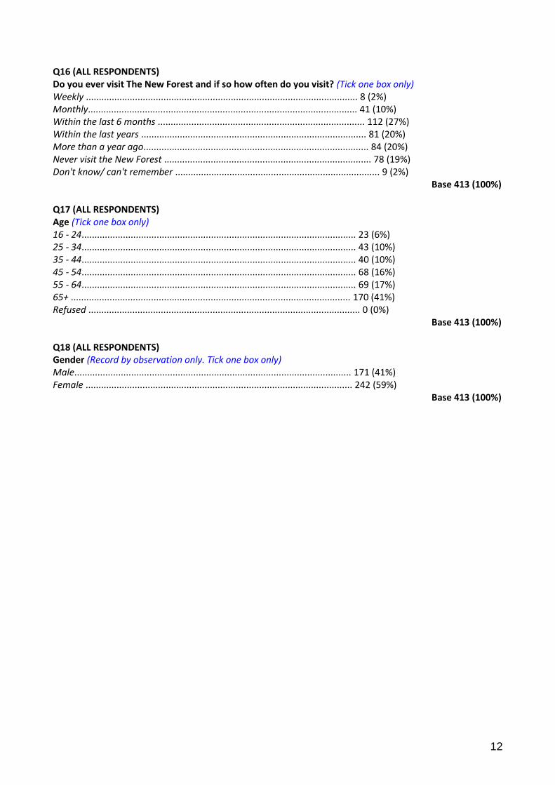
Q16 (ALL RESPONDENTS) Do you ever visit The New Forest and if so how often do you visit? (Tick one box only) Weekly ......................................................................................................... 8 (2%) Monthly........................................................................................................ 41 (10%) Within the last 6 months ................................................................................ 112 (27%) Within the last years ....................................................................................... 81 (20%) More than a year ago....................................................................................... 84 (20%) Never visit the New Forest ................................................................................ 78 (19%) Don't know/ can't remember ............................................................................... 9 (2%)
Base 413 (100%) Q17 (ALL RESPONDENTS) Age (Tick one box only) 16 - 24.......................................................................................................... 23 (6%) 25 - 34.......................................................................................................... 43 (10%) 35 - 44.......................................................................................................... 40 (10%) 45 - 54.......................................................................................................... 68 (16%) 55 - 64.......................................................................................................... 69 (17%) 65+ ............................................................................................................ 170 (41%) Refused ......................................................................................................... 0 (0%)
Base 413 (100%) Q18 (ALL RESPONDENTS) Gender (Record by observation only. Tick one box only) Male........................................................................................................... 171 (41%) Female ....................................................................................................... 242 (59%)
Base 413 (100%)